 |
Caribbean Hurricane Network
- 2 0 1 5 Season - |
|
|
|
2015 Atlantic Hurricane Season |
|
| Ana | Bill | Claudette | Danny | Erika | Fred | Grace | Henri | Ida | Joaquin | Kate | |
The 2015 hurricane season was a slightly below average season. There were eleven named storms, of which 4 became a hurricane and two major hurricanes. Erika, 'just' a tropical storm, caused the most havoc on the Islands, esp. Dominica which had devastating floods and 30 fatalities. Another notable storm was Joaquin, a storm that quickly developed into a Category 4 hurricane off the Bahamas. It was supposed to make a turn northward, but did too late, stalling as a Cat.4 storm over some of the islands... Because of their impact Erika and Joaquin will no longer be used in the 6-year rotating list of names. They will be replaced with Elsa and Julian.
Following is an archive of all weather discussions Dave and I posted. They are in reverse chronological order, with the most recent storm discussion on top. If you want more background in formation on specific storms, I have found the 2015 Atlantic Hurricane Season section in the Wikipedia a great resource. Also, visit the Hurricane Research Division of NOAA's Atlantic Oceanographic and Meteorological Lab for 'best track' data of all 2015 storms. The track map below is from that website as well.
- - 2015 Hurricane Tracks - -
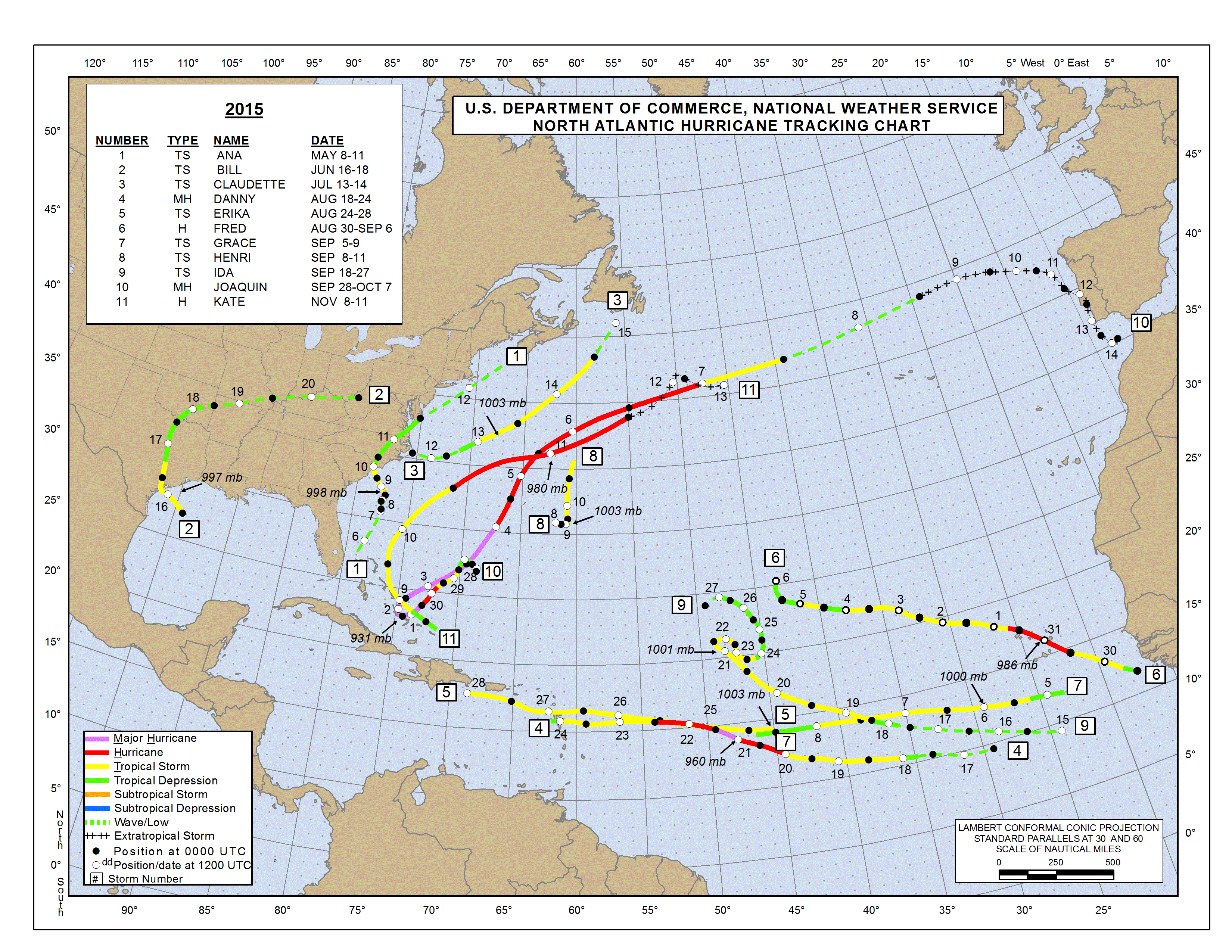
- - Source: NOAA/AOML Hurricane Research Division (click on image for larger size) - -
Weather discussions by Gert & Dave during the 2015 Atlantic Hurricane Season. The homepage with the links to local reports from the islands, latest satellite image, current weather outlook can be found here.
Sunday, December 6, 2015 10:57AM PST - 2015 Season is Over!
- And another hurricane season is behind us! A relatively quiet one, with 11 named storms and 4 hurricanes, of which two were major ones (Danny and Joaquin). For the Caribbean Tropical Storm Erika caused a lot of destruction in Dominica. At least 31 people died, 890 homes destroyed, entire villages flattened, and over 14,000 people were rendered homeless. And then we had Joaquin, who was supposed to turn before it reached the Bahamas, but didn't, and quickly strenthened into a Category 4 storm when it slowly passed over Crooked Island, Acklins Island, Long Island, Rum Cay and San Salvador. Hopefully 2016 will be nicer to us! -Gert
Sunday, November 8, 2015 22:13PM EST
- TD#12, Kate?
-
Good Sunday evening!
Quick note, just when you thought it was really over, an unwanted tropical surprise shows up in the form of TD #12 and is looking to join the season ending dance as our next TS, Kate.
Having drenched and blessed us here in the Virgin Islands and Puerto Rico with needed rains, the system is now around the SE Bahamas. Tropical Storm warnings are up for the SE Bahamas, Central Bahamas and the NW Bahamas as probable TS Kate passes through the next 24-48 hours.
Gusty winds and heavy rains will prevail in the Turks & Caicos and the Bahamas warning areas as it moves to the NW at 14 mph. At this time, almost all computer models show no direct effects on the continental US as this late bloomer is expected to be escorted off the tropical dance floor by a sagging front coming off the US east coast.
More tomorrow. Have a good evening!
Dave
Friday, October 23, 2015 07:52AM PDT - Patricia: 200mph!
- I was reading the advisories for Patricia, just off the west coast of Mexico and had to do a double take: sustained winds at 200mph! Minimum central pressure at 880mbar! In comparison, Katrina had max. sustained winds of 175mph and 902mbar minimum pressure, Luis was 140mph, 935mbar... So this is a huge storm! Worse, it is less than 12 hours from making landfall!
It is expected to move between Puerto Vallarta and Manzanillo. The closest point of approach with Puerto Vallarta is only about 32 miles and for Manzanillo about 60 miles. According to the advisories hurricane force winds extend outward only up to 30 miles (tropical storm winds 175 miles), so that's good for the lovely city of Puerto Vallarta. However, for people directly in Patricia's path it is bad. At least the hurricane is expected to move quite fast and will weaken rapidly while over land. But there will be mud slides and flooding, a dangerous storm surge, etc. Not a good situation at all.
You can calculate the closest point of approach on this page. Latitude/longitude coordinates for Puerto Vallarta 20.67N, 105.27W and Manzanillo 19.05N, 104.32W. Advisories on the National Hurricane Center website. Stay safe out there! -Gert
Update: Jeff Masters from Wunderground just wrote on his excellent blog: "Stunning, historic, mind-blogging, and catastrophic: that sums up Hurricane Patricia, which intensified to an incredible-strength Category 5 storm with 200 mph winds overnight.". Read more on Patricia, including threats to Manzanillo on his blog...
Monday, October 5, 2015 09:40AM PDT - Another Invest
- Wow, pretty busy on the storm front. Joaquin is moving away from Bermuda. I am trying to get some reports from my correspondents on the island. I have just posted on the Bahamas-page a link to our Facebook page where I shared some pictures from other people. And now we have another Invest. It is currently about 1000 miles from the islands. The National Hurricane Center gives it a very low probability that it will become something. However, since the model tracks (spaghetti plots) have it track over the northeastern Leeward Island we have to keep an eye on it. Also, some models do actually forecast it to be a tropical storm or even a hurricane in 48 hours, which seems unlikely to me. Stay tuned... -Gert
Sunday, October 4, 2015 09:55AM PDT - Bermuda
- The center of Joaquin is expected to pass just about 80 miles to the west of Bermuda. The island is officially just outside sustained hurricane storm force winds, but for sure will have gusts of that force and sustained tropical storm force winds. The strongest part of the storm is to the south east, so basically the tail. Apart from the wind the storm surge might pose a problem as well. Luckily Bermuda seems always very well prepared for these kind of storms, so hopefully all goes well. It will be a whole different situation than it was for the Bahamas where Joaquin as a Category 4 storm just sat for a few days.
As for the Bahamas, I wish I was getting more updates. I have found some Facebook pages, Long Island and San Salvador. If you know of other good sources, please let me know. -Gert
Saturday, October 3, 2015 14:43PM EDT
- Borderline 5 Joaquin
-
Good afternoon,
Finally. We received some blessed rainfall here in the VI, mostly this morning in the form of a small train of thunderstorms which continue to rumble at this moment, all courtesy of the tail of Hurricane Joaquin as he lumbers off for a date with Bermuda on Sunday afternoon. As he pulls away from ravaging the Central Bahamas, he is dragging deep tropical moisture northward and that is why we woke up to some tremendous thunder and torrential downpours this morning. Power has dropped sporadically around the northern islands but for the most part, WAPA has stayed on.
Hurricane Joaquin was just upgraded to a high level Cat 4 hurricane as of the 2 pm advisory with a special advisory put out around noon by the NHC after a hurricane hunter aircraft penetrated the eye wall and found flight level winds exceeding 155 mph with higher gusts. After their usual adjustments, verifications and tweaking, they decided to keep the surface wind speeds at 155 mph, one mph less than Category 5 minimum. Based on the intensification factors from earlier today and the jump in wind speed, I'd say it is a Cat 5 but we are splitting hairs here. 1 mph isn't going to a make any difference to those on the ground in the middle of Joaquin.
Will it maintain this intensity for long? Maybe into the evening but he has picked up some speed and will soon start to lose some oomph as he encounters slightly cooler waters and some increased wind shear. However, the waters around Bermuda are still between 83-85 degrees so Joaquin will still be a major hurricane as it passes by to the west. However, weebles wobble and if this weeble wobbles just a bit to the east, Bermuda, one of the best prepared islands in the Atlantic, will take a major hit.
Last note on Joaquin. Until he is past Bermuda and curving east, do not get complacent upper east coast. Wrong turns have happened before.
90L, the former artist known as TS Ida, is still lurking to the east of Joaquin and actually is assisting his escape from the Bahamas to the NE. While a chance for rejuvenation still exists, 90L is probably a goner after Joaquin exits the arena.
While all eyes have been on Joaquin, the low over Florida and 90L, several waves have been creeping up from behind off to the east. One has not exited the African coast yet but will in a day or so while a lower tropical wave is showing very slow signs of waking up SW of the Cape Verde islands. Traditionally, activity slows in this region tropical formation wise but this has not been a normal traditional season so they bear watching regardless.
Prayers and thoughts with all who have endured the seemingly endless wrath of Hurricane Joaquin.
Dave
Friday, October 2, 2015 10:16AM PDT - Move on please!
- Joaquin is still beating up the Bahamas. Now a Category 4 storm with 130 mph sustained winds! The center is currently over Rum Cay and moving at just 3 mph... This is not a good situation. I haven't heard much from my hurricane correspondents on the Bahamas, for obvious reasons. As soon as I get some news it will be posted on the Bahamas reports page. I have also opened up the Pleas for Help forums. There might be other (better) discussion forums elsewhere, but I created them just in case. E-mail me or post on the forum if you know of any other good resources. The Pleas for Help forums can be found at: help.stormcarib.com.
On another note... with model forecasts trending eastward, Bermuda should take note of this storm as well. -Gert
Thursday, October 1, 2015 08:37AM PDT - Waaah, Joaquin
- From the latest advisory: ...EYE OF JOAQUIN PASSING OVER SAMANA CAYS IN THE BAHAMAS... ...CENTRAL BAHAMAS TO EXPERIENCE HURRICANE FORCE WINDS...STORM SURGE...AND HEAVY RAIN THROUGH TONIGHT..., not something I wanted to see! The turn north didn't pan out as quickly as expected, but it will! It got a lot closer to the Bahamas than earlier forecasted, and it will even get a bit closer! In 12 hours Joaquin should turn sharply. So you see again, do not look just at the forecasted track, but at the whole picture. The cone of uncertainty is your friend!
Joaquin now a major hurricane, and it is expected to get even stronger, a Cat.4, getting energy from the warm Gulf Stream. Adding to this is that Joaquin is nearly stationary. So it is not looking good right now for the Bahamas. Esp. Samana Cay (located just north of Crooked Island), Crooked Island, Acklins Island, Long Island, San Salvador, Eleuthera, etc. A nice map has been posted by Esther on the Bahamas updates page. Also, the Turks and Caicos Islands are getting slammed right now as well, but they are a bit further away from the center.
The only positive I see is that the strongest winds are on the Eastern side. But the low lying Bahamas will have to deal with storm surge and rainfall, esp. since Joaquin is moving so slowly. It will not be until about 2 days before Joaquin is out of the area! Use the tools above, like the Closest Point of Apprach calculator with satellite image overlay to see the size of the storm, to assess your situation. But above all, heed local warnings! Updates from the Bahamas and TCI will be posted as soon as I receive them. -Gert
10:08AM PDT Update: I mentioned above that the Cone of Uncertainty is your friend, but maybe not always, like now! See this blog post by Brian McNoldy Why the forecast cone of uncertainty is inadequate for Hurricane Joaquin.
Wednesday, September 30, 2015 08:56AM EDT
- Hurricane Joaquin
-
Good morning,
Guess Hurricane Joaquin did not get the memo that a very strong El Nino was prevalent, supposedly suppressing the formation of intense storms this season and has put himself in a potential position to raise havoc in the Bahamas and potentially the East Coast and New England where the nightmares of Superstorm Sandy continue to ring resoundingly through many residents memories and pocketbooks.
Just upgraded to a minimal Cat 1 hurricane, Joaquin's central pressure has dropped from last nights 990 mb to 971 mb and it's quite possible a rapid intensification phase could occur due to the extreme heat content of the ocean waters surrounding the Bahamas and a lessening of the wind shear which has so far prevented total consolidation of the thunderstorms with other convection around the center of circulation. Moisture and instability from former TS Ida and the low sitting over northern Florida contribute to this equation. Even if rapid intensification does not take place, Joaquin will strengthen and I can see him reaching Category 3 major hurricane status eventually.
This bodes ill for the eastern and central Bahamas where hurricane warnings are up and watches posted for the northern Bahamas. Moving a paltry 6 mph to the SW, Joaquin is only digging further southward before an expected west and then eventually northern turn, like "right turn Clyde". As it turns northward, most of the islands that it hit already coming into the Bahamas would be under the gun on a continuous basis so a long lasting lashing would be devastating.
Once headed northward, spaghetti models earn their name as they are scattered from west to east and the exact track and intensity by Sunday is very far from finite so I will not conclude anything at this point. Will Joaquin be pulled close to the coast and ride the trough all the way to New England? Will it make landfall in the Carolinas? Or will it be kicked out to sea as forecast by one of the more reliable major computer models?
Regardless of a definitive track, flash flooding and rip currents, coastal flooding and erosion, storm surge and yes, wind damage are all a reality here.The dynamics are in place for a hurricane strike from North Carolina to New England and combined with other weather features, a Sandy like "left turn" into the coast is a good possibility.
Since, as the NHC says, confidence is low on the track after 3 days from this point, everyone should be getting prepared. Hopefully, Sandy taught a lesson never to be forgotten and heeded.
Dave
Tuesday, September 29, 2015 15:11PM PDT - Hmmm, Bahamas
- The latest advisory show Joaquin much closer to the Bahamas than yesterday, plus it is now expected to be a hurricane. The Closest Point of Approach with San Salvador, Bahamas is now only 65 miles, and 100 miles with Cat Island, in 2 days. So I do expect the Bahamas to issue watches soon. Stay tuned... -Gert
Tuesday, September 29, 2015 09:18AM PDT - Joaquin and the US
- Just a quick update, Joaquin is drifting west but should be moving north in 2-3 days. As of right now it doesn't like it will make landfall in the US. But things can change. Please, for people on the East Coast check out the tools about, and see if you are in the Cone of Uncertainty, also, you can use the Closest Point of Approach calculator to see how close the storm can get to you. I have listed many cities on the US coast to make it easy for you. Although Joaquin is not expected to be a hurricane, don't underestimate it. Stay alert! -Gert
Monday, September 28, 2015 21:01PM PDT - Joaquin
- Tropical depression 11 was upgraded to the 10th tropical storm of the season, Joaquin. It is located about 450 miles east northeast of Nassau, the Bahamas. It will get a bit closer to the Bahamas, but should curve north well before. Right now the Closest Point of Approach with Abaco is 235 miles. A pretty safe distance. Also, Joaquin is not expected to strengthen into a hurricane. So all good as it looks right now, but let's keep an eye on him, just to be sure. -Gert
Tuesday, September 22, 2015 09:42AM PDT - Ida
- Normally I would be very worried when I look at the satellite image above. The big blob, that is Tropical Storm Ida, looks quite threatening. Luckily models are in very good agreement that it doesn't come towards us, but after drifting to the east, so actually back to Africa, it will go north, a storm for the fishes.
There is also another invest out there, off the coast of North Carolina, US, that is no threat to us either. For the rest, no tropical cyclone development for the next 5 days (and more...). Nice! -Gert
Sunday, September 20, 2015 11:13AM EDT
- POOF!
-
Good morning!
96L has gone the way of TD#9 that is "POOF"!
96L really didn't have much going for it except a very elongated area of low pressure and encircling surface winds plus the very warm waters of the gulfstream and as such, wasn't able to pull itself together so now, it is just a rip current, high waves along the coast generating system.
TD#9 survived longer than expected but eventually dry air entrainment and wind shear blew all the convection off to the NE as it climbed further north leaving an exposed and vulnerable core separated from it's top and has since met it's demise.
TS Ida is now the sole player in the Atlantic basin and really isn't that formidable at all. Running into dry air and moderate wind shear, the possibilities of TS Ida turning into a hurricane are getting remoter by the hour as she treks WNW. For her future, she has two possibilities: get picked up by a trough and carried off to the NE or miss her bus stop and then be forced to wander aimlessly in the Atlantic desert region for a few days. Either way, chances of landfall are vetch and vetch nachi (slim and none) for the US and Caribbean.
Across Africa the wave train seems to have missed picking up some pax as the number of waves is pretty slim. However, it only takes one to start the ball rolling!
Locally, the seas are very flat ironed and the breeze negligible with some rains on the northside and hot everywhere else! I can almost skip a flat stone to Jost Van Dyke from Redhook!
Dave
Friday, September 18, 2015 09:30AM PDT - Two tropical depressions
- Currently we have two tropical depressions in the Atlantic. They should both be going north well before the reach the islands, so no threat to us. Number Nine will not even reach tropical storm strength. Number Ten will probably become Ida in 36 hours. So a nice little break, esp. for Dominica! -Gert
Wednesday, September 16, 2015 07:51AM EDT
- History and now
-
Good morning!
At this almost exact time, 7:12 am twenty years ago (1995), I emerged from my bunkered apartment on Skyline Drive overlooking the Northside of St. Thomas to a landscape forever altered by Cat 3 Hurricane Marilyn's direct hit overnight.
80% of homes and businesses were destroyed, intact roofs were almost non-existent, vegetation was negligible having been literally blown off trees and shrubs, and an eerie calm was evident which added to an almost supernatural moment. Stung by a Jack Spaniard almost immediately as I stepped on my porch, I realized even the animals were pretty much homeless. He was dazed by the sheer enormity of the disaster as I was.
You learn a lot about people after something like that happens. Selfishness, rudeness, an "I am the big I am" mentality and greed were some of the not so pleasant attributes exhibited. But, sheer tenacity, willpower, faith, and determination were powerful attributes that overcame and dominated. You definitely learn a lot about yourself, what you are truly made of and how thankful you are to be alive. When simple things we take for granted every day like an ice cube, a hot shower, electricity, even freedom (mandatory curfew) are non-existent, you realize how lucky you really are, to live where you do despite the obstacles.
That's history. Currently, we have 2 active Invests, 93L and 95L while old 94L lumbered into Mexico and is no longer an NHC project. 93L looks a lot better than yesterdays elongated mess and is very close to depression status but if it wants a name for itself, it better hurry as it's approaching the wind shear death zone and will be relegated rather quickly, much like it's predecessors. Moving to the NW, 93L should be the fish storm it was forecast to be but after 5 days things could get interesting for the east coast or Bermuda if a few models have anything to say.
95L, SW of the Cape Verde Islands is in a much better position to transition to a tropical depression and/or storm as the SSTs are favorable, wind shear is modest, and that pesky Saharan Dust is not much of a factor as far south as 95L is. It also is in a better position to move more westward, dodging the troughs to the north that could for recurvature. As long as it remains weak, the more westward track is the favorite.
Several more strong waves will be rolling off the African continent over the next few weeks and vigilance is always a necessity. Also, the GOM and the Western Caribbean could see some action by the end of the month. Time keeps on ticking, ticking, ticking.....
Dave
Monday, September 14, 2015 10:57AM PDT - Three invests
- There are three invests, 2 Cape Verde's and one in the Gulf of Mexico. Both Atlantic ones have a good chance of becoming the next tropical storms (Ida and Joaquin). However, as it looks now, they should curve north well before they reach the islands.
Meanwhile, another tropical wave is passing over Dominica, bringing some more showers while they really want to dry out. The remnants of Grace are moving over Jamaica and Cuba now. -Gert
Friday, September 11, 2015 14:23PM PDT - It's raining in Dominica...
- Looks like the remnants of Grace spread out even more. It is raining a lot more in Dominica than expected, judging from the local reports and looking at mySatellite and the radar. Esp. on the radar you can see how the bands of rain don't just move over Dominica, but kind of just get stuck in the mountains. Not good when the soil is already saturated with water. Looks like it is on the last rain band so hopefully it is over soon. At least this time a flood warning has been issued by the Dominica Meteorological Service. -Gert
Friday, September 11, 2015 06:44AM EDT
- Sub Henri, Grace bloom and Mid season
-
Good morning!
First a pause for thought for the events and memories of 9/11 and what has transpired since and how the world and our lives changed forever from that traumatic and catastrophic morning.
Fortunately, we have nothing of the sort in the Atlantic basin but we do have some areas of interest as today is also the historical half way point in the Atlantic hurricane season. Almost 11 1/2 weeks left officially or 80 days.
TS Henri is now Subtropical storm Henri as it makes its way north at a good clip of 16 mph. While some strengthening is still possible, Henri is only a threat to shipping interests and maybe the tip of Newfoundland and eventually bound for the British Isles as of the latest forecast track. Once it gets away from those nice, warm gulfstream waters, Henri will run smack into the frigid waters of the North Atlantic and transition into an extra tropical entity. Short lived, no resume, but still, a name to add to the growing list of un-memorables in this El Nino year with the only exception so far, TS Erika.
The remnants of Grace are blooming off to the east of the northern Lesser Antilles and I agree, looking better than she ever did as a named storm with one exception: no closed circulation. Wind shear is strong in the neighborhood and the likelihood of a Lazarus like resurrection is slight. However, as I mentioned a few days ago, it is still possible these remnants could make a weak comeback after passing through the shear of death zone that has mostly protected our islands from what could easily have been 3 hurricanes. Sadly, with the exception of Dominica, it has chased badly needed rain away as well. The next 36 hours should bring some decent downpours to help alleviate the drought especially since her remains have blossomed overnight.
Our next wave to rumble off the coast of Africa had a fighting chance while still on land and with marginally favorable conditions ahead which includes a seasonal downturn in the Saharan Dust factor, it is expected to develop into possibly Ida next week for but right now, Graces remains look healthier than this wave. Long range forecast rate this a potential "fish storm" but nothing has been normal this season.
The GOM, (Gulf of Mexico) has been unusually quiet this season but activity has been noted signaling possible development in the Western Gulf. If something does spin up, likely impacts will be heavy rain in northern Mexico and Texas as its proximity to land will be the main growth inhibiting factor.
TGIF!
Dave
Thursday, September 10, 2015 13:50PM PDT - Here comes what's left of Grace
- There are no advisories issued on Grace anymore, since it is not a tropical cyclone. The Tropical Weather Discussion states that there are 20-25kt (23-29mph) winds associated with the remnants of Grace, mostly to the northeast. So the main wind threat is gone. That doesn't mean that the rain/flooding threat is over. Right now there is still a lot of convection visible on satellite images. The system should move over the Leeward Islands tomorrow, bringing some welcome rain, hopefully not too much. It looks like the main 'blob' will pass north of Dominica, so that's good. Other than that, a new tropical wave came off Africa that has some potential of becoming something. We'll see how this one pans out. Seems like it never stops... -Gert
Wednesday, September 9, 2015 07:58AM PDT - Bye, bye Grace
- Grace couldn't keep it together and is now just a tropical wave. At the moment not too much convection either, good for Dominica, disappointing for others, when it moves over the islands on Friday. There is also a strong tropical wave crossing the islands more south, bringing some welcome rain but interfering with some home improvement jobs on Grenada.
We also have a new depression, number Eight, about 200 miles east of Bermuda. It is expected to become Tropical Storm Henri later today. Fortunately it is moving north, not threatening any land. -Gert
Monday, September 7, 2015 18:33PM EDT
- Graceless
-
Good holiday evening!
TS Grace started off with bang but appears to be losing her grace courtesy of the omnipresent wind shear and a run in with that continuous dry air mass of of Saharan Dust which is slowly diminishing in intensity as it usually does this time of year.
Track wise, Grace will have a limited time to rejuvenate but it will come at the end of her run, after reaching the islands and hopefully dropping some much needed rainfall everywhere but Dominica. Elsewhere from Africa, a few more waves will exit but none ominous at this point so early.
92L east of Bermuda is a surprising entity but looks to be unimpressive and should remain a fish storm headed to the great North Atlantic graveyard. The GOM however, does have some potential in the next two weeks and does bear watching. Florida once again looking at heavy rains soon.
Dave
Monday, September 7, 2015 10:12AM PDT - Grace
- And here we have another tropical storm following in Danny and Erika's footsteps, Grace. The good news is that it is looking a bit weaker than earlier, even better, it is supposed to weaken even more! Since Grace is still over 1700 miles away it will still take a little less than 4 days to reach us. By that time the forecast indicates that Grace should be just a tropical depression. So wind-wise we should be OK. As we saw in Dominica we should still be watchful with the amount of rainfall it can bring. Grace is moving towards the west, and as of now the forecast has Grace cross the island chain around Guadeloupe Friday AM. This is just north of Dominica, so hopefully there won't be too much rainfall associated with this storm. Be aware that since the storm is still 4 days away, the cone of uncertainty includes a much larger area, basically from St.Lucia all the way north. Stay tuned... -Gert
Saturday, September 5, 2015 09:43AM PDT - Luis - Twenty Years Ago
- Today marks the 20th anniversary of Hurricane Luis, a massive category 5 storm with a 45 miles diameter eye. This was my introduction to not only the destructive forces of a hurricane itself, but also how stressful and complicated the aftermath is. My in-laws were living on St.Maarten at that time. When we saw them that Christmas, months after the storm, we were shocked what the stress of the hurricane had done to them.
This storm was also the inspiration for this website. We were travelling through Greece and Israel for my studies when the hurricane hit and could not get in contact with our family. Newspaper reports were minimal and not helpful, like: "St.Maarten was hit by a hurricane. We are unsure of how many people survived.", adding to the stress. The internet was not like it is now, it was very hard to get 'real' non-sensational non-generalized information on what was going on on the islands. It is very stressful for people 'outside' to not know what is going on. This website has hopefully helped many people put their mind a bit at ease, by reading what the local hurricane correspondents report, and by communicating with each other through the Pleas for Help board. Hopefully it will be a long time before we have a bad storm like this! -Gert
Saturday, September 5, 2015 09:19AM EDT
- Resurrection of Fred? 91L
-
Good morning,
The wandering nomad and survivalist we know as still TS Fred is due to be downgraded soon due to very hostile wind shear, recurve to the NE, rejuvenate from depression or even remnant low status, and re emerge as a TS again, all in the span of 5 days after which he could be impacting the Azores. Fred remains only a threat to shipping interests but his longevity is impressive given the Atlantic's hostile environment.
91L. Given a very high chance of development by the NHC, 91L could very soon become a TD or even jump to TS status as TS Grace. This system looks pretty good on recent satellite loop imagery and is moving to the west more rapidly than its predecessors at 13 knots or 14.96 mph. The longer this system stays disorganized or weak, the more westerly trek it will take. TS Fred is still exhibiting some influence and until he fully exits and recurves, he will still exert some detrimental influence on 91L. That should be occurring soon.
So, with moderate wind shear and some favorable SSTs ahead, there is no reason to that 91L will be TS Grace in the very near future. Most models continue her trek to the W and WNW as a TS and of course, being shredded by our protective shield of Caribbean wind shear as she approaches the islands; much like her previous contenders Danny and Erika.
However, the caveat is always there: computer models have a very poor analysis of tropical systems that are weak and or disorganized. Without a defined COC, their analysis is subject to a widespread error margin.
Time will tell. Hopefully, whatever it is as an entity, if and when it reaches the islands, will bring us the rains we were promised from Danny and Erika and left bereft instead.
Dave
Sunday, August 30, 2015 09:56AM EDT
- Ex-Erika, Fred and then some!
-
Good morning!
Prayers and thoughts to those who live in Dominica as the TS Erika pummeled the island with a foot of rain in some areas, including the capital city of Roseau and the city of Portsmouth. I reserve my comments on the government there who did not issue watches or warnings to the populace as they expected the center to be 100 miles to their north but still, it's better to be safe than sorry. In this case, it was deadly.
Meanwhile after the remnants of Erika dropped copious amounts of rain on the Dominican Republic, Haiti, and portions of Cuba, she still retains the possibility of rising like a phoenix and re-emerging from the tropical cyclone dirt pile as a tropical depression in the coming day or two as the system now plows into the Bahamas and South Florida. After traversing the Dominican Republic. whose mountains wreaked havoc on her circulation forcing her capitulation as a weirdly and historically disorganized tropical system who followed no computer model or human forecasts, Ex-Erika is likely to wipe out the drought or at least significantly alleviate it in South Florida; something she forgot to do here in the Virgin Islands. Flooding is likely due to the torrential downpours all at once but the sand and limestone structure of Florida's soil allows for that flooding to quickly diminish but the damage potential is there nevertheless. There is also the small possibility of a trek west of the peninsula into the Gulf of Mexico itself. She hasn't listened to anyone in the first place, why now? We will see. Be prepared regardless.
TS Fred. Possibly Hurricane Fred. Where? SE of the Cape Verde Islands. The potential for hitting the Caribbean is miniscule due to the steering currents in place but after seeing Danny and Erika's polka around this area this week, one begins to wonder. Most likely trek is over the Cape Verde Islands as a strong TS or even a Cat 1 hurricane moving WNW and then flattening out on a more westerly trek. Basically a "fish storm" after leaving the Cape Verdes for at least 3-4 days.
Has a hurricane ever made a direct on the Cape Verde Islands, oh so close to the African Coast? I've seen this question asked on a few other sites. The answer is no since recordkeeping began in 1851. Have they been brushed by any hurricanes? Yes several times. 1947 (Ft. Lauderdale hurricane), 1948, 1957 and most recently a close call with Hurricane Jeanne in 1998 according to historical records. No damage or injuries were ever recorded by these flybys.
A tropical wave is affecting the northern islands at the moment but all the rain seems to be avoiding the land masses this morning while another wave is off to the east of Barbados and has a few concentrated storm close together but nothing significant.
Have a good yet safe Sunday!
Dave
Saturday, August 29, 2015 11:24AM PDT - Bye bye Erika
- Not sad at all to say goodbye to Erika! Although the remnants can still produce inches of rainfall over Cuba, Turks&Caicos, the Bahamas and Florida. Very sad to hear about the devastation on Dominica though. The death toll stands at 20 people now, with many missing as well. I have had contact with one of my hurricane correspondents, and hopefully she can report later. It will be posted on the Dominica web page. You can donate to the Red Cross of Dominica through this website (I do not think this is a scam). I also found a fundraising site on Indiegogo, but I don't know those people so can not vouch for it. The Government of Dominica has also set up a Recovery and Reconstruction Fund. There is also ReliefWeb. Just to make it clear, the call for donations above is for running the website, etc., it does not go to Dominica storm relief (unless I receive a surplus in donations, since I don't want to make money running the Caribbean Hurricane Network).
As you might have noticed above there is another Invest, 99L that just rolled off the African coast. Looking at the model runs it will go nicely north, so should not be a threat to the islands! -Gert
Friday, August 28, 2015 07:32AM EDT
- Very Fickle Erika
-
Good morning,
Before I dozed off last night, I noted a 47 mph wind gust on the east end of St. Thomas where I live with virtually no rain involved. Average sustained winds were around 35 mph but higher up the mountains. The towel brigade is not happy as they and all of us here were looking forward to a good soaking to alleviate the drought. Why no rain?
Northwesterly wind shear is the answer. This shear has and continues to push most of TS Erikas convection to the south-southeast. As we were on the northern side of the system, we received some of the stronger winds but none of the accompanying rain. On a good and surprising note, our WAPA (Water and Power Authority) stayed on all night with some fluctuations and limited outages on St. Thomas/St. John while St. Croix suffered more extensive outages from early evening.
On St. Croix more damage has been reported due to its closer proximity to the center of Erika. I do not have anything concrete at the moment but all ports in the US Virgin Islands remain at condition Zulu meaning they are closed to inbound and outbound traffic until a security assessment has been completed. A curfew has been instituted by Governor Mapp until 5 pm this evening, peace officers have been deputized and prices are frozen. I believe this is mainly meant for St. Croix but he says its for all of the territory. Problem is, many business owners and others are ignoring the curfew here on St. Thomas.
TS Erika is now approx. 60 miles south of Puerto Rico heading in the direction of the Dominican Republic. Discombobulated by the NW shear, the center is elongated and out in front of the convection. Until the center can relocate underneath this convection, strengthening will not occur, at least anything of the rapid kind which bodes ill will for Erikas future due to the mountainous terrain of the DR which could be her demise. Rains, much needed rains, are heading into Puerto Rico still but not on the scale once predicted and much needed. We here in the VI and BVI definitely didn't see much in the way of those needed rains either.
Down the road, warnings are up for the Bahamas, Turks and Caicos and the cone includes all of Florida. Its a wait and see what happens to Erika after her encounter with the DR. She might survive as TS or TD or be torn apart and relegated to an open tropical wave.
While all are looking west, the east is going to get active again shortly. Time to look in both directions.
Now I have to see if I can get to work. More later.
Dave
Thursday, August 27, 2015 09:46AM PDT - Dominica
- Although there were no tropical storm warnings or watches for Dominica because the center of the storm was supposed to pass about 100 miles to the north, the island is being greatly affected by Erika. I guess forecasters forgot that the brunt of the system was to the south of the center... Again, as often with a tropical system, the winds are not the biggest problem, but the rains associated with the system. So even though Dominica might not have had sustained tropical force winds (so a tropical storm warning was not warranted I guess), they did for sure experience tropical storm conditions! Maybe they should change the definition of a tropical storm warning/watch.
There are reports of widespread flooding (incl. the airport), landslides, and widespread power outages. Unfortunately two people are confirmed dead and as many as 5 people are missing. I am trying to get some news from my special hurricane correspondents on the island (posted on the Dominica page), but with no power it will be hard. For other news check out Google News Full Coverage. -Gert
Thursday, August 27, 2015 07:08AM EDT
- Which Erika will show up today?
-
Good morning!
Dawn here in the US Virgin Islands and all is pretty quiet as TS Erika passes between Guadeloupe and Antigua at this time with maximum winds now up to 50 mph with higher gusts based upon a Hurricane Hunter recon flight.
Overnight, Erika put on a new convective display, which is normal for tropical systems to do during the nighttime, diminishing thoughts she was done for as she looked like an ICU patient yesterday. This morning, she is bringing beneficial rains to the region which has been in severe drought although too much in a hurry in some places and flooding will be a problem if she slows down even more.
Forecast is for no real change in intensity the next few days although fluctuations will be apparent up, down or both. The track is still a bit wobbly though as Erika goes a bit north then a bit south but still pressing generally westward. Current track puts Erika going between the US Virgin islands of St. Thomas/St. John/Water Island and St. Croix late tonight still in the 50 mph intensity range. TS force winds extend out still over a hundred miles so things will start to ramp up late afternoon and early evening.
Here in USVI, all ports are subject to Condition Zulu which means all inbound and outbound traffic is prohibited. Shelters have been opened, more sandbags have been handed out, and non-essential government employees were given today off. Airports are open though until further notice as only some steady but gusty winds and scattered showers are occurring now.
Once Erika passes by tonight and Puerto Rico as well, things get interesting. Will stronger wind shear ahead relegate her to open wave status or will she be able to fend the shear off and become a serious threat to Florida, the Carolinas, and the Bahamas, pounding the Turks and Caicos along the way? Time will tell but if I was up there, I'd be preparing. Complacency is a bad thing.
A final thought this morning. That dry air and wind shear we have been complaining about all season that has contributed to the drought situation just might have been our savior from possible back to back hurricanes.
Dave.
Wednesday, August 26, 2015 20:58PM PDT - Erika Closest Point of Approach
- I always tell people not too focus too much on the track, but see below the closest point of approach for the center of the storm for several of the islands (I excluded the Bahamas, TCI and Hispaniola because it is too far out (=too uncertain)). Keep in mind that the brunt of the storm is to the south of the center. Check for yourself with the CPA calculator and overlay the map with the latest satellite image to get a better feeling of this tropical storm. Also, keep in mind that tropical storm force winds extend outward up to 105 miles, at the current speed that means you can feel those about 6 hours earlier...
Tortola: 3.7miles (Thursday, August 27 at 9:00PM AST)
Antigua: 6.9m (Thursday, August 27 at 7:54AM AST)
St.John: 8.1m (Thursday, August 27 at 9:36PM AST)
St.Eustatius: 13.9m (Thursday, August 27 at 1:36PM AST)
St.Barths: 15.9m (Thursday, August 27 at 1:54PM AST)
St.Thomas: 16.3m (Thursday, August 27 at 10:30PM AST)
St.Kitts: 16.8m (Thursday, August 27 at 12:12AM AST)
St.Maarten/St.Martin: 17.8m (Thursday, August 27 at 3:06PM AST)
Anguilla: 28.3m (Thursday, August 27 at 3:18PM AST)
San Juan, Puerto Rico: 38.8m (Friday, August 28 at 2:00AM AST)
St.Croix: 50.6m (Thursday, August 27 at 8:42PM AST)
Guadeloupe: 56.5m (Thursday, August 27 at 4:54AM AST)
Mayaguez, Puerto Rico: 83.9m (Friday, August 28 at 5:30AM AST)
Dominica: 99.9m (Thursday, August 27 at 2:30AM AST)
-Gert
Wednesday, August 26, 2015 07:14AM EDT
- Watches and Warnings
-
Good morning!
All quiet before the storm in most areas as TS Erika is swiftly approaching from the ESE necessitating the following watches and warnings:
Tropical Storm Warning:
Anguilla, Saba and St. Eustatius, St. Maarten, Montserrat, Antigua and Barbuda, St. Kitts and Nevis, Puerto Rico, Vieques, Culebra, U.S. Virgin Islands and British Virgin Islands.
Tropical Storm Watches:
St. Martin
St. Barthelemy (St. Barths)
Guadeloupe
Currently, TS Erika is holding at top winds of 40 mph with higher gusts and is expected to slowly strengthen as her size is her weapon against dry air intrusion. Wind shear is moderate but will increase down the road hence one reason for her slow rather than rapid or steady intensification. Another reason is her size. Much larger than Danny was, Erika will be slower to grow in the near term and also slower to weaken once all is said and done.
TS Erika has been flexing her muscles this morning with some convective bursts of energy and also appears to have slowed her forward progress a bit according to recent animated satellite imagery. Hurricane Hunters and NOAA have been in the system since yesterday and continues to find a disorganized storm trying to get going though.
Prognosis continues to reflect a TS Erika crossing the mid to Northern Leewards as a weak but very slowly intensifying storm. Entering the island chain somewhere between St. Kitts and Antigua, late tonight and visiting the British and US Virgin Islands tomorrow late afternoon into the night, Erika should remain below strong TS status. However, at this time, TS force winds extend outwards of 105 miles so her tentacles will be felt long before the COC gets to you.
As usual, these forecasts are not in stone as tropical systems have a mind of their own which is one reason why weather is an inexact science. If it were exact, there would be no need to project and forecast. We would know definitively. Its best to just be prepared, aware of your surroundings, and use common sense.
Heavy rains and the subsequent flooding is expected to be a biggest issue with TS Erika. Unlike Danny, who never realized his potential as a rainmaker, TS Erika will dump 2-4 inches in many areas with higher amounts up to 6-8 in isolated spots. While we need the rain, we don't need it all at once and runoff will be a big problem due to the hard ground resulting from the droughts inability to soak it up fast enough.
Further up the road the T&C Islands and the Bahamas should be really focused, especially if TS Erika survives her interaction with land and a few days of higher wind shear. Florida, I've shared with you for several days now you need to be wary. Even the GOM is not out of play yet.
More later.
Dave
Tuesday, August 25, 2015 14:55PM EDT
- Erika survival
-
Good afternoon,
Not a whole lot to go one at the moment as TS Erika looks like a rag doll who has been chewed by a Scottish Terrier. Dry air and wind shear, the villains in the Danny saga, are at it again trying to beat Erika down. While that is good news on the intensity side, it is not good news for those who need the rains that Danny didn't drop and also for the forecasters as some models say she will wimp out and the other forecast a strong system in the T& C Islands, Bahamas, maybe Florida and the East coast.
Another factor against Erika is she is doing her best speed polka imitation at 19 mph which is really not allowing her figure to align itself where she can grow up and be a contender. A trough is expected to drop down far enough and pick Erika up for a turn more northerly after it passes the Leewards but she could also plow into Hispaniola as the weak storm she is now and get torn apart by the mountains.
Hurricane Hunters will be the system as Gert noted later today and a NOAA research aircraft is as well checking out upper level winds and steering currents. Between the two, plus our satellites, all the data collected will be fed into the models and we will have a clearer picture of just what Erika wants to do or her intentions anyway.
Florida, I still would not discount this storm. Too early.
More later.
Dave
Tuesday, August 25, 2015 09:23AM PDT - Tropical Storm Watches Issued for Erika
- Yes, Erika is almost here! Tropical storm watches (meaning tropical storm conditions are possible within 48 hours) have been issued for the following islands: Montserrat, Antigua, Barbuda, St. Kitts, Nevis, Anguilla, Saba, St. Eustatius, St. Maarten, Guadeloupe, St. Martin, and St. Barthelemy. So take notice!
Erika doesn't look as impressive on satellite imagery anymore, but it is still a tropical storm. Hurricane hunters will be flying through the storm later today in order to get a better picture. Erika is expected to stay a tropical storm by the time it reaches the islands, but might strengthen into a hurricane after 3 days. However, forecast models don't agree well on intensity nor track. There is still a lot of uncertainty, esp. after 3 days. So, again, the cone of uncertainty (see above) is your friend. Stay tuned! -Gert
Monday, August 24, 2015 19:51PM PDT - Tropical Storm Erika
- Quick update. Danny has just dissipated and now we have the next tropical storm on our doorstep. Right now it looks like it will reach the islands by Thursday AM. The current track takes it just north of Barbuda, St.Maarten/St.Martin and Anguilla. Erika is expected to still be a tropical storm by the time it reaches the islands. Use the Closest Point of Approach tool to see how close it can get to you! Esp. for now, don't focus too much on the exact track, since it might change a lot. Looking at the spaghetti model plots I actually wouldn't be surprised if it passes the islands just to the north, but maybe that is my wishful thinking. In any case, it is better to see if you are in the cone of uncertainty. -Gert
Monday, August 24, 2015 14:37PM PDT - Next storm arriving this Wednesday?
- All eyes are still focused on what is leftover of Danny, but I hope that people realize that Invest 98L is closely behind. It might still look far away (over 900 miles), but it is moving at about twice the speed as Danny. It might arrive Wednesday night already! On the satellite image above it is the impressive blob in the lower right. It is not even a tropical depression yet, but I just want to make people aware that something is coming! -Gert
Monday, August 24, 2015 12:27PM EDT
- Newly Hatched TD?
-
Good afternoon!
A quick update.
While former major (briefly) hurricane Danny has been relegated to remnant status as a trough of low pressure, the NHC will soon designate 98L as a tropical depression and might even skip that and go right to Tropical Storm Erika depending on the timing of the announcement. While moving at a fast clip of 22kts, it still cannot outrun all the dry air plus it is not giving itself any time to build itself up and congeal so it's forward speed is currently a detriment. Still, erring on the side of caution, a later announcement is probable.
The remnants of Danny meanwhile have decided to fire up a ball of convection just to the NE of Guadeloupe in the last few hours revealing the refusal of this system to quit as it has refused all along. More convection means more rains along its path but we will see if this burst remains or it was a last ditch effort.
Dave
Monday, August 24, 2015 08:04AM EDT
- Danny the Dwarf/Erika?
-
Good morning!
I was going to post last night but the internet poofed so that was the end of that.
Speaking of the end, TS Danny is looking down that narrow tunnel heading into the light of death as strong wind shear and that seemingly never ending dry air layer aka Saharan Dust plus lower humidity levels ahead all but ensure his demise. This does not mean he is totally dead down the road as he could resurrect after passing the Dominican Republic but the chances of a Phoenix like appearance are remote. Due to this weakening, Tropical storm watches have been dropped for Puerto Rico and the Virgin Islands as well.
Like Pluto is now called a dwarf planet, Danny was once a dwarf hurricane with an eyewall only 10 nm in diameter. In fact 1 1/2 Danny size hurricanes could have fit into Typhoon Goni in the Pacific which just raised havoc on southern Japan! Now, no longer a dwarf but no longer a hurricane either. As a matter of fact, it might only be a depression at best since part of its center is exposed in the south and south west and this "center" is also displaced to the south of the main convective blob. Size wise, Danny has increased for several reasons: one is the elongation created by the strong wind shear effect and the second is it's own weakening. When a system weakens, they tend to expand.
Now affecting the middle islands like Guadaloupe and Dominica, Danny's more southern track will still shed copious amounts of much needed and gratefully received rainfall over all the Virgin Islands and Puerto Rico starting this afternoon and overnight when it should be the heaviest as a depression at best and an open but vigorous wave at the least. All of the Virgins should feel a few gusts to TS strength but it will be windy and rainy with some intense lightning for the most part.
Behind Danny is 98L, now given an 80% chance of development into at least a depression within the next 48 hours but looking on satellite imagery like a tropical storm already and might be named a TD or Erika at 11 am today. Located approx. 14N42W, 98L is trucking along at a rapid 20kts and should be approaching the Windwards by Wednesday morning. Current tracking forecast puts soon to be Erika on a similar but more northwesterly trail with potential more intense impacts on the islands. Intensity is hard to forecast at this moment until the center is closed off but once again, the weaker storm will trek farther south and a stronger one will trek more northerly. Either way, more steady rains will be beneficial.
Florida and the east coast might want to watch soon to be Erika as a more northerly track could make it interesting south of the Bahamas.
Elsewhere, 97L is soon to be vanquished by the cold North Atlantic and as such, no tropical threat while the train of waves rolling off the coast of Africa continues on cue and needs to be monitored. Stay tuned and stay safe!
Dave
Sunday, August 23, 2015 19:59PM PDT - Barely a tropical storm
- Danny is still hanging in there as a tropical storm, but barely. The track is also a lot more southward than yesterday or even this morning. The center might now pass between Guadeloupe and Dominica. Tropical storm warnings and watches are still in effect for some islands, but have been dropped for the USVI, Puerto Rico and Vieques and Culebra (see advisories. Strangely enough no tropical storm watch or even a warning is in effect for Dominca.
It should be noted that when you look at the satellite images that the center of the storm is not where you think it is. The center is actually below the big 'blob'. So keep that in mind when you look at the forecasted track. Tropical storm force winds still extend outward up to 105 miles (mostly northeastern quadrant). So all in all it is looking good. Hope the islands get a nice drenching, which is much needed, without flooding and mudslides... But don't put away those hurricane shutters yet, there is another candidate coming our way, 98L invest, probably Erika soon (see tools above). -Gert
Sunday, August 23, 2015 05:38AM EDT
- Danny warnings and watches
-
Good Sunday morning,
Just a quick early Sunday morning update as to the warnings and watches posted by the islands and nations in TS Danny's way. They are:
A Tropical Storm Warning is in effect for...
* Antigua, Barbuda, Montserrat, St. Kitts, Nevis, and Anguilla

A Tropical Storm Watch is in effect for...
* Saba and St. Eustatius
* St. Maarten
* Guadeloupe, St. Barthelemy, and St. Martin
These are as of the 5 am advisory today, Sunday August 23rd. Note that individual governments post watches and warnings for tropical systems and not the NHC which does for the US jurisdictions.
Danny is expected to weaken further as it makes its way towards the islands and is expected to cross within 10 miles of Montserrat on Mondayafternoon. Check out the tools above for closet point of approach. This also puts probable TD Danny approx. 8 miles south of St. Croix early Tuesday morning.
Weakening is expected to continue and this is why a slightly more southern track is now expected.
97L really isn't doing much nor is expected to swirling north of Bermuda while some models develop98L into major hurricane Erika in about 10 days making a beeline for the northern Leewards. The African wave machine is in full gear so time to be fully prepared if Danny hasn't prompted you enough already.
More tonight.
Dave
Saturday, August 22, 2015 13:51PM PDT - 5PM Update - A little weaker Danny
- Short 5PM update: Danny is indeed weakening! It is now barely a hurricane. So that's good. The track has shifted a bit more northward, good for Antigua, St.Kitts and Nevis, Saba, Statia, Monserrat, St.Croix and Puerto Rico. Worse for St.Barths, St.Maarten/St.Martin. But again, don't focus too much on the track, a little wobble to the south and you are in it! Instead, look at the cone of uncertainty (see above). Stay safe! -Gert
Saturday, August 22, 2015 09:56AM PDT - Tropical Storm Watches issued
- Little Danny is not looking as perfect anymore compared to yesterday, and the trend of weakening should continue. It is 'only' a Category 1 hurricane, down from a Category 3, and should be 'just' a tropical storm by the time it reaches the islands on Monday. Therefore tropical storm watches have been issued for the following islands: Antigua, Barbuda, Guadeloupe, Montserrat, St. Kitts, Nevis, Anguilla, Saba, Statia, St.Barths and St. Maarten/St.Martin. It is a small storm, with hurricane winds at this time only extending outward from the center up to 15 miles, and tropical storm winds extending outward about 60 miles. Be aware that some schools will be closed, and that flights will be cancelled.
The islands now being targeted are in a drought and can use some rain, but with the ground so dry and hard it might have some problem absorbing large amounts of rain. Since this is a small system, and since it is not expected to hang around too long, rainfall totals are not expected to be massive so it might not be too much of a problem (hopefully).
Its current track is more to the north again, esp. later. The storm might now actually pass Puerto Rico to the north. This scenario is worse for the Turks&Caicos and the Bahamas. So take note! Esp. since by that time some of the models predict that Danny might have become a hurricane again.
Everyone in the cone of uncertainty (see above) please be prepared! Don't think it is 'just' a tropical storm. We have had surprises before. And also, during the storm, stay safe, don't do stupid things! -Gert
Friday, August 21, 2015 08:37AM PDT - Category 2 Hurricane Danny
- 2PM update: Danny is now a Category 3 hurricane (just like Dave predicted below)
As always, Dave gave a really nice overview of what is going on with Danny. Now that the 11AM advisories were published I want to add two points. Danny is now a Category 2 Hurricane, and might still be a hurricane when it reaches the islands, although the official forecast thinks it will weaken to a tropical storm just before. But we should be prepared for a hurricane. Secondly, the forecasts tracks are trending northward with each advisory. So the storm probably will go a bit more north than currently forecasted. It is always better to see if you are in the cone of uncertainty (see links above), rather than focus on the thin line on the map. This is one of those storms when there is ample time to prepare. Better use it! -Gert
Friday, August 21, 2015 09:49AM EDT
- Survivor Danny
-
Good morning!
Hurricane Danny has a small window of opportunity, about 12-18 hours, to reach Cat 2 or possibly even Major Cat 3 status for a brief time before being beaten up by increasingly hostile wind shear and that omnipresent dry, dust filled air from the Sahara. This was not deemed remotely feasible Wednesday as then TS Danny was being eaten alive by the snake like entrainment of dry air into its core, almost relegating Danny to depression or mere open wave status. However, the little system that could, and I do mean little as denoted by it's 10 NM eye at present, is in survival mode and now attack mode, however brief.
Most models are in consensus of a turn to the west and a run through the Northern Windwards with an almost direct hit on the island of St. Kitts Monday afternoon as a strong tropical storm followed by a skirmish with St. Croix as a declining TS and a second hit on the southern coast of Puerto Rico near Ponce as a weak tropical storm due to it's death run in with wind shear and dry air influx.
Eerily similar to the track of Hurricane Frederic of 1979, Danny may, (playing devils advocate here), keep surprising as it goes along, especially if it reaches major status or strong Cat 2 before shear and dry air impact since it will still be in tandem with a moisture field. An impact after Puerto Rico in the Dominican Republic will almost certainly finish Danny off but after the remnants reach the GOM, who knows? Or if the ridge has a small inherent weakness? History does repeat itself!
Best case results will be minor wind damage and a whole heap of rain. Problematic is the rainfall amounts over drought ravaged areas. If the rain falls too fast, flooding will result as the ground will not be able to soak it up fast enough. Hopefully, steadier rains will prevail.
At this time, it looks like we dodged a bullet this time Caribbean but I wouldn't get too comfortable until Danny starts to weaken. Looking around the suddenly active Atlantic we have an Invest 97L north of Bermuda which might develop. Hindering the cold front coming across the NE right now, its only other effects will be felt in the Canadian Maritimes and Nova Scotia.
Eastward, even though it's El Nino time, Danny and the other lesser knows have paved a small road for the next few contenders to possibly rise. One hasn't even left the African coast yet and already had percentage chances of development while another in the water off the coast has possibilities too. Heart of the season folks. It only takes one.
Dave
Thursday, August 20, 2015 08:53AM PDT - Hurricane Danny
- Danny is looking a lot better today, or worse, depending on how you look at it. An eye has been visible on recent satellite images, so not surprisingly it has been upgraded to a hurricane, the first of the season. Danny is moving westward at just 12mph, so it will still take four days to cover the thousand miles to the islands.
With the uncertainty how the dry air ahead will interact with this small hurricane, models don't really agree on Danny's future. Some models call for a weaker storm, tracking more south, while others for a more stronger storm, going more north, maybe even north of the islands. The official forecast from the National Hurricane Center takes it close to Antigua in 4 days still as a Category 1 hurricane, but weakening to a tropical storm by the time it reaches Puerto Rico (see Closest Point of Approach-calculator). So still four days away, a lot can happen. At least I am happy to see that it won't strengthen to a Category 2 storm. But we'll see, we have had surprises before, we really have to take this storm serious. -Gert
Wednesday, August 19, 2015 22:30PM EDT
- Danny Survival Skills
-
Good evening!
While Danny came to fruition as the models and forecast foretold, his life span is in the hands of different factions of weather and conditions. The opponents are: dry Saharan air to the west and the north entraining itself into the circulation of Danny thereby disrupting the convective process, a stubborn refusal to cut the umbilical cord to the ITCZ which is also a hindrance to survival on its own, and cooler SSTs just ahead.
Still, by staying low the proponents are a decent shield of moisture surrounding the system that still exists despite the dry air entrainment, low wind shear, and a rebuilding of its convective core now ongoing. So, Danny is not dead but will probably not reach Cat 2 status either. Still, despite the obstacles, Danny should reach hurricane status by or on Friday as it crosses into more friendly SSTs.
The course and intensity: Once again, a weaker Danny will stay on a more westerly and southerly track while a stronger system will trek more WNW. Either way, Danny will more than likely pass through the middle Windwards as a weak Cat 1 or strong TS OR take the WNW route and strike or just pass to the north of the northern Leewards. Not a ton of difference here. Intensity has been lowered due to the dry air entrainment likely to continue, higher wind shear coming out of the Eastern Caribbean not to mention the lack of Cat 2 status being achieved before reaching the islands in the first place.
Forward speed has been increased over the next few days and the ETA for the islands starting to feel the effects are Monday night into Tues morning depending on track.
This is not to say these insights and forecast are cut in stone. We have been fooled before but learn from each experience. Just because it looks like it will not be as bad as initially forecast does not mean stand down your guard. Changes can occur quickly as we all know. And we have a lot of hurricane season left.
Dave
Wednesday, August 19, 2015 08:41AM PDT - Danny
- Yesterday tropical depression four was upgraded to Tropical Storm Danny. There are two changes from the earlier forecasts. The first one is that it looks like Danny will take a more northerly track, taking it to the Leeward Islands by Monday. Secondly, the intensity forecast shows that Danny would probably not become a Category 2 storm after all. There is a battle ahead with dry air of the Saharan Air Layer, not good for development. So hopefully Danny will lose this battle and won't even be a hurricane by the time it reaches the islands. It is still far out there (1400 miles), so a lot can change. In the meantime, use the tools above to calculate your closest point of approach, view advisories, spaghetti plots and more. Stay tuned! -Gert
Tuesday, August 18, 2015 13:51PM EDT
- TD#4
-
Good afternoon!
Well, well, well, the little system that thought it could pull away from the clutches of the ITCZ (Inter tropical convergence zone) has finally managed to do just that and we now have TD#4, soon to become TS Danny as early as of the 5 pm advisory.
It is also forecast to become the Atlantic Basins first hurricane of 2015 and conditions over the next 5 days favor that forecast with the only wild card being a humongous area of dry Saharan air to it's north. SST (sea surface temperatures) are plenty warm enough, wind shear is negligible compared to the roar it has been all season and it is surrounded by a decent area of moisture laden air which is keeping the Saharan dust from intruding, at least for now.
But what will it be when it reaches the islands? Hmmmm, depends on the track really. The more it stays west and south of the dry air to the north means a stronger system as it plows through the mid to lower Windward Islands as some models have forecast. If it climbs in latitude, it will run into that dry air which is actually moving in tandem with the system. This could hinder development significantly. It depends on just how strong Danny gets before severe interaction with that dust. This scenario also tracks Danny more N and NNW which puts the middle to the top of the chain Windward Islands and the easternmost Leewards in its sights maybe as a Cat 2 or even 3.
There is a lot of ocean between now TD#4 and the Windwards so time to plan and prepare. This far out it is hard to forecast exactly, and as I've said previously, weather is an inexact science.
Behind TD#4 is more contenders as the pretenders have preceded already. A few of the waves in the next few weeks are expected to develop as well as we head into the meat of the tropical season.
Be watchful and ready.
Dave
Tuesday, August 18, 2015 09:37AM PDT - Number Four
- The Invest has been upgraded to Tropical Depression Four. It is still far out there and won't be until next week before it reaches the Islands. A bit too early to tell, but it looks more south than I thought yesterday. This storm is also expected to become the first hurricane of the season. The advisories even make it a Category 2 in five days. There is still a lot of dry air from the Saharan Air Layer to deal with (see image on the satellite page), so we'll see if it is still a hurricane when it reaches the islands, or even becomes one at all. In any case, keep a close eye on this one. We have had surprises before! -Gert
Monday, August 17, 2015 08:44AM PDT - Some development...
- There is a new invest still far out (over 1500 miles) in the Atlantic. Our first 'Cape Verde' storm of the season. The National Hurricane Center gives it a 70% chance to become a tropical depression in 5 days. When you squint your eyes a bit the spaghetti plots of model forecasts (see links above) show a west-northwest track, which might bring it to the Leeward Islands in 5-6 days. It might even become our first hurricane (Danny). However, since the 'storm' is still not a storm you have to take these forecast with a grain of salt. Conditions are not that great for rapid development, there is a lot of vertical wind shear and some dry air ahead. But still, we will be closely following the progress of the tropical wave. -Gert
Friday, August 7, 2015 15:18PM EDT
- Latest CSU Forecast
-
Good afternoon,
While the beautiful blue skies have returned to the NE Caribbean and the Saharan Dust level has abated to a mouse-like roar, the chances of any decent rainfall or a droughtbuster of a system are abysmal at best with the UN-abated wind shear still raising havoc on any tropical wave or potential developer past 55-60 degrees W. So far, the central Atlantic has been a virtual graveyard for the early season contenders and if one survives past that point, the wind shear demonstrates a lethal weather knockout leaving only a wimp of the former self to continue on.
Still, the season is entering it's historically most active period mid month and with that an obvious increase in potential. The latest Colorado State University forecast is for a total of 8 named storms, (we've already had 3), 2 hurricanes (0 yet) and one of those a major. The main overwhelming reason is the strong El Nino.
The waves are lining up across Africa with increasing intensity and impressiveness. Time and El Nino will tell if we have survivors from that direction. Best chances are still the GOM and the East Coast.
Dave
Friday, July 31, 2015 10:13AM EDT
- Waves and rain
-
Good morning!
Droughtdom has spread across the land and it doesn't look like an end is anytime near much less a good soaking. With Saharan dust and wind shear conspiring to be the death knell of any wave even trying to rise through the tropical ranks, prospects look dim for the near future. The outlook near term anyway is spotty showers today, a dry weekend, and another weak and dusty wave to cross the area Monday.
Longer term, 94L still is struggling and will likely fizzle in the Central Atlantic. While most Saharan dust is above 15 N and wind shear moderate, 94L is still dancing with the ITCZ and until it pulls away from that, it will have a hard time getting anything organized going. If it does, then ahead and above lie much drier air and increased wind shear with hostile intentions. The wind shear by itself has ripped the tops of anything getting close to the Eastern Caribbean apart thanks in humongous part to a still strengthening El Nino. We will see. Maybe it will be the little system that thinks it can. if anything, please bring some good rains!
The Gulf of Mexico (GOM) is quiet as is the East Coast but the GOM is getting ripe while the East Coast, if something does form, will be spared major wrath as these fronts keep coming down from Canada and Central US.
The African continent will be spitting out some decent waves in the next few weeks but I do not see anything large coming out of any of these until at least mid-August.
Stay aware and prepared regardless.
Dave
Tuesday, July 21, 2015 08:36AM EDT
- Down the road
-
Good morning!
Three short lived tropical storms are what we have so far this hurricane season with two of them making landfall (TS Ana in South Carolina between Myrtle and North Myrtle Beach and TS Bill on Matagorda Island, Texas) and the third, Claudette, a fleeting runner from the northern east coast to the Canadian Maritimes. Lastly, 93L died a quicker death than anticipated as it was expected to at least put up a fight until it reached about 55W.
It's quiet now but the end of this month and into August we should see some activity flair up; first, more than likely, along the east coast of the US, possibly mid next week. The Atlantic conveyor belt should also show some stirring as the Saharan Dust Layer abates, warmer Sea Surface Temperatures appear, and wind shear weakens somewhat. El Nino will obviously have a say in all this.
The continent of Africa is starting to jack up it's production of tropical waves and each one that rolls off the coast paves the way for the one behind it with better atmospheric moisture. There already are a few pretty impressive ones ready to hit the water but will they survive?
The drought continues meanwhile here in the NE Caribbean and Puerto Rico. A spit of rain here and there from the weak waves already rolling through helps but definitely not enough. Most of it is just nuisance rain so after it passes, the roads are slick, your cistern was the unlucky recipient of dusty water running off your roofs and your car looks like someone threw a bunch of dirty brown drops all over it. Of course, this happens after you wash it yourself.
Yes it's supposed to be quiet but it pays to be watchful regardless.
Dave
Friday, July 17, 2015 14:07PM EDT
- 93L
-
Good afternoon from the drought stricken NE Caribbean!
While no one wishes for a full blown hurricane, other than out of work contractors, many who I have talked to recently have been wishing for a slow moving minimal tropical storm, tropical depression or just a real well defined and active tropical wave to alleviate the drought conditions here in the NE Caribbean including Puerto Rico. 93L just "might" be our first alleviation.
Key word is "might". 93L is currently located approx. 1000 miles SSW of the Caper Verde islands. While the near term bodes moderately well for some development, the long term does anything but. Near term, the sea surface temperatures (SST), are at the minimum for sustainable development and slow at that, while in an atmosphere of decent moisture. An anti-cyclone is directly above the perceived center of the system (I'm not saying circulation because there is not a defined circulation yet) which is assisting in the minimization of wind shear. The one downside for the near term is 93L's forward speed. It needs to slow down so that vertical enhancement can take place. With that said, for a very early CV or Cape Verde spawned system, the chance for development into a named storm, weak as it may become, is a decent possibility. But, that window is short lived.
The long term prospects for an actual named system surviving into the Caribbean are possible but at the remote end of the scale. Models which do not handle non-named systems mostly bring 93L or whatever it is in 5 days, to the NE Caribbean. By that time, the ingestion of dry Saharan Dust ladened air will have stifled development while jet stream-like wind shear (driven by El Nino) will effectively kill what's left over.
It will be very interesting to see how this plays out. One thing it will definitely do is start to moisten the atmosphere for future waves. The draconian grip of the SAL (Saharan Air Level) appears to be loosening which is good news for allergy and drought sufferers alike. Not to mention a pretty blue sky has been hard to come by lately!
Keep an eye to the east. It's early and the forecast for the number of storms in all categories is down mainly due to a strong El Nino. But we have had bad tropical systems in previous strong El Nino years. Andrew? Remember, it only takes one.
Dave
Monday, July 13, 2015 11:51AM PDT - Third Storm of the Season
- A new tropical storm has formed well off the coast of the US, named Claudette. It is moving north-northeast and poses no threat to the Caribbean. Claudette is expected to be a short-lived storm since it will find much cooler waters ahead. Another one down :-) -Gert
Tuesday, June 16, 2015 09:43AM PDT - Tropical Storm Bill
- Short update... as Dave was eluding to yesterday, we have now Tropical Storm Bill, and is about to make landfall on Matagorda Island, Texas. The biggest threat will be the havey rainfall associated with this system. No threat to the Caribbean. You can use the handy tools above to find more info on this storm. -Gert
Monday, June 15, 2015 18:29PM EDT
- Almost TS Bill
-
Good afternoon!
Been traveling to and from my Moms 70th Birthday celebration and finally had a chance to say a small bit of what is happening in the Western Gulf of Mexico. While we tend to focus on the Caribbean, this system actually started to form in the Western Caribbean as moisture from Carlos crossed Central America and the birthing of 91L began.
More than likely, soon to be named TS Bill, will impact the Texas coast sometime tomorrow morning with the main threat of life threatening heavy rains and consequential flooding over an already over-saturated land. The hurricane hunters were investigating today and found no closed low level circulation which means no named status as of yet. However, thunderstorm activity has started to encircle the low levels and wind shear, hostile today, will relax a bit thereby giving 91L a small window of opportunity to attain TS status.
Nevertheless, the main threat is heavy rains and flooding where the rains are definitely not needed. Coastal erosion will be heavy and the winds, at times. will cause some damage but nothing will be worse than the flooding rains.
Those of us in the Caribbean should take heed and stay or get prepared. It is the season.
Dave (From Miami Int Airport)
Tuesday, June 2, 2015 08:50AM PDT - Official start!
- Yesterday was the official start of the 2015 hurricane season. As noted earlier expectations are that it is going to be a slow one! The new forecast by Klotzbach & Gray from Colorado State Univ. updated June 1 shows 8 named storms (+1 because of Ana, 12 is normal), 3 hurricanes (6.5 is normal) and just 1 major hurricane (2 are normal).
The probability of at least one named storm making (is)landfall somewhere in the Caribbean is 75% (96% is normal), chances for a hurricane are 46% (75% is normal) and a major one 22% (42% is normal). This might seem high, but keep in mind that these numbers cover the whole Caribbean (10-20°N, 60-88°W, a large area), not just one island. For just Puerto Rico for example, a relatively large island, the probability of a major hurricane tracking within 50 miles of the island are just 2%.
Reasons for the expected slow season is the high chances of a strong El Niño forming and 'unfavorable conditions' (ie., cool) in the tropical Atlantic. In any case, as we always preach, it takes only one to spoil a season. On Brian McNoldy's blog, guest blogger Michael Laca (TROPMET.com is exploring the validity of the 'it only takes one' mantra. So please, everybody, start preparing now! Check those hurricane shutters, find your flashlights and get some extra batteries, check your first aid kit, etc., etc., and keep an eye on this website! -Gert
Saturday, May 23, 2015 12:23PM PDT - New Season!
- Hallo everybody! Can you believe it is only 9 days until Hurricane Season officially starts? This will be the 20th season that I have been doing this! Can you believe it!? Some of the hurricane correspondents have been doing this for all this time as well! Who knew :-). Remember, this is just a 'hobby' of mine, and I always hope to recoup my expenses through ads and donations. So, please, help out again if you can.
Hopefully this season will be just as quiet as last year, when we only had 8 named storms. And it might very well be, the early forecast by Klotzbach&Gray (see below) shows only 7 named storms. This because it could be an El Nino year again (although last year it fizzled out a bit). Even though we had an early storm (Ana), it doesn't mean that it will be a busy season (see also some statistical analyses I did 10 years back).
I just made the website ready for the 2015 Atlantic Hurricane Season. For this I always have to move a lot of files around, and hopefully I didn't break anything... Hopefully you are getting your early preparations in as well. It is never too late to start thinking about storm shutters, emergency supplies, batteries, etc... In any case, welcome again to the new season, hope it will be a boring one!
-Gert
Wednesday, May 13, 2015 18:39PM EDT
- First wave
-
Good afternoon!
Well, TS Ana sure caused an early stir to the pre-2015 Atlantic Hurricane season along the middle East Coast with drenching rains, beach erosion, dangerous rip currents (all rip currents are dangerous, what a cliché) and an early warning the tropical storm season 2015 is upon us.
Now, the climate is quiet in this hemisphere once again with copious amounts of Saharan Dust choking the moisture out of the atmosphere, strangling many landscapes and drying cisterns (plus wallets because it cost a lot of money to fill them back up with water) all across the Eastern Caribbean. The SAL stretches across to the west coast of Africa in various densities but, a moisture pod is about to exit the African coast. A 1006 mb low is about to enter the far eastern Atlantic.
The Eumetsat satellite featuring the African continent shows this low leaving land just above the ITCZ which means, for the most part, interaction and non tropical formation. Not only because of the timing is so early in the season, but the interaction, coupled with the dry Saharan Dust and cooler sea surface temperatures, will keep its possibilities very limited.
We here in the VI, BVI and down island all the way to Grenada are suffering a dearth of rain. Dry season started late this year and is continuing into a normally wetter period of May. Our islands are browning. Not good!
Be prepared!
Dave
Monday, May 4, 2015 08:10AM EDT
- Ana?
-
Good morning!!
It has been quite a while since my last post, for obvious reasons, and this one is a bit early as far as talking about a possible named storm 27 days before the official start of the 2015 Atlantic Hurricane Season.
A disorganized low over Cuba will meander it's way across the Straits of Florida and into the Bahamas over the next few days and possibly stall out east of the Carolinas due to weak steering currents in the upper atmosphere. These same weak steering currents, in combination with unusually warm Atlantic coast waters for this time of year and its slow movement in the first place could enhance possible tropical development up to weak TS status. It could also develop into a hybrid system with some tropical and non tropical characteristics combined. Then again, if it doesn't close off the circulation, it will remain a potent low.
Will it become the first named storm of the season, TS Ana? Good possibility. They will name it even if it is a hybrid system if the low closes off. Major effects of this system in all scenarios will be high wave action and subsequent beach erosion, street flooding in South Florida and the Bahamas cases, dangerous conditions for shipping and fisherman, and deadly rip currents all along the coast.
Where will it go towards the end of the week? Will it get picked up by the jet stream and a front carries it away across the Atlantic towards Europe? Or not get picked up and wander west into the middle east coast states? Early season storms historically tend to hug closer to the coast so no surprise if it goes west.
Preparation saves lives. Property can be replaced. You can't.
Dave
Thursday, April 9, 2015 14:41PM PDT - Quiet season ahead!?
- It is that time of the year again for the traditional forecast of the upcoming hurricane season by Klotzbach&Gray at Colorado State University. Some good news, it is supposed to be a quiet season. They predict only 7 named storms (normal is 12) of which 3 will become a hurricane (6.5 is normal), one of those will grow into a major hurricane (Category 3 and up). The main reason for it is that it should be an El Niño year again and the relatively cold sea surface temperatures in the tropical Atlantic.
We were supposed to have an El Niño during last hurricane season as well, but it formed later and was weaker than expected, but we had still a relatively quiet season. This year most dynamical models are calling for a moderate to strong El Niño event from August to October, nicely during the traditional peak of hurricane season. Hopefully this all pans out, but as always, remember that even in a slow season, that one big hurricane could make landfall on your beautiful island! -Gert
Maintained & moderated by: Gert van Dijken (gert@gobeach.com).
Weather discussions also by Dave McDermott, St.Thomas, USVI.