|
|
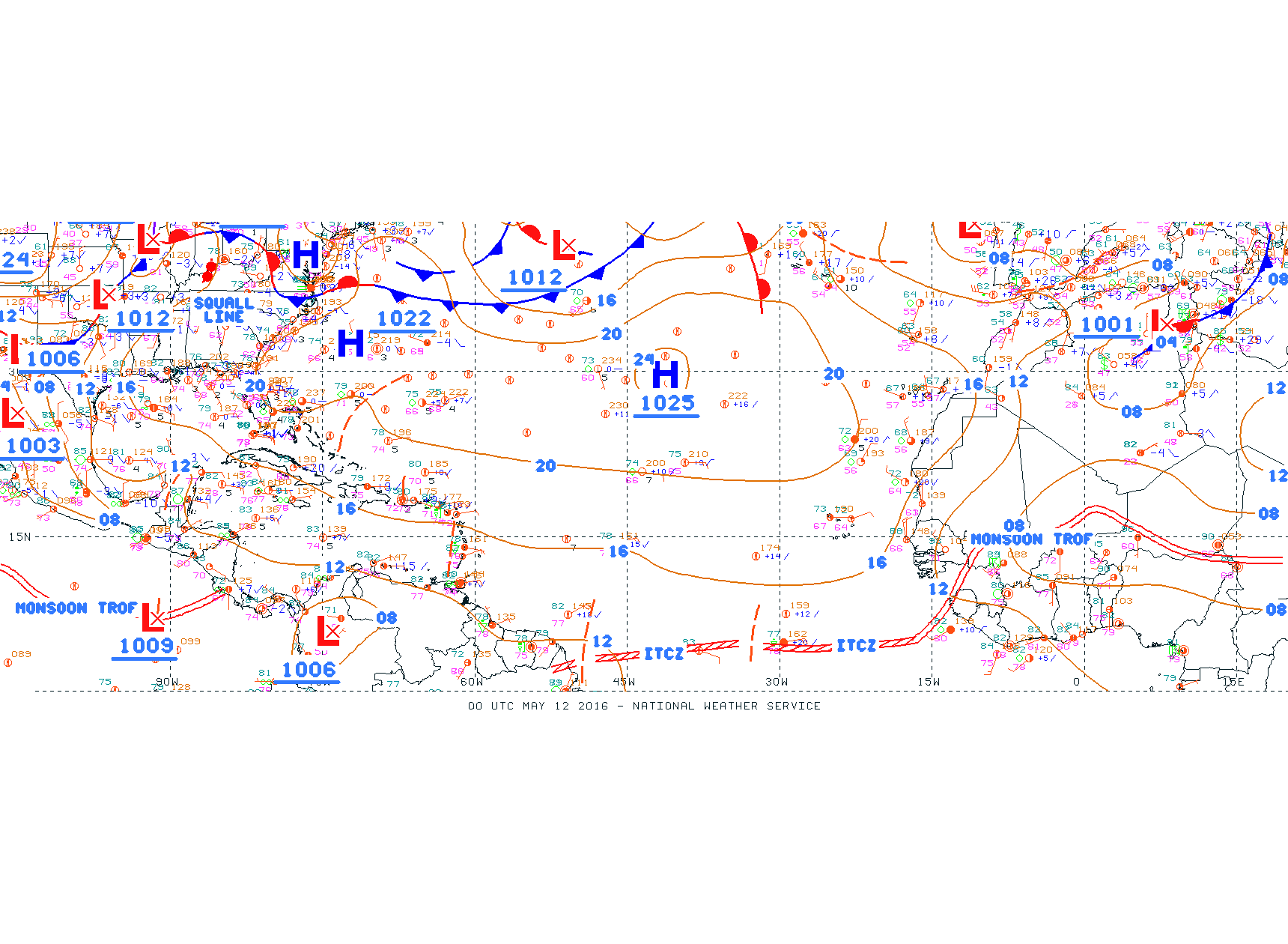
- - - 2015 Hurricane Season - - -
|
- Rally, ... !
|
- By Ian Martin Borde <readkrox51 at gmail.com>
- Date: Thu, 26 May 2016 15:46:36 -0400
|
Let's say a prayer of reprieve, for The Bahamas, recovering from last year.
(North, South Carolina and Georgia).
God Bless ! |
|
- Reprieve - 36 hrs.
|
- By Ian Martin Borde <readkrox51 at gmail.com>
- Date: Mon, 16 May 2016 11:55:37 -0400
|
Good Day, Good Everything, People of Paradise,
The branches of the vine never gets more than it could bear. In like manner, we have a 36 hour reprieve before something similar to the last three days reoccur.
Listen, I really don't want to know if I am right or whatever? Because it's not for money or to help me personally. And I think you should do the same.
We have enough trouble procuring tools and equipment and keeping them working. So let's work on that instead.
God Bless
Attachment:
- Maracas -.jpg
Description: JPEG image
Attachment:
Matelot catch 2016-04-04.jpg
Description: JPEG image
|
|
- Consistent Convection
|
- By Ian Martin Borde <readkrox51 at gmail.com>
- Date: Thu, 12 May 2016 03:20:42 -0400
|
Good Day, Good Everything, People of Paradise
One can safely say,
"Today is a day to take out your boots."
God Bless
Attachment:
12th may 2016 - 0145am.gif
Description: GIF image
Attachment:
12th may 2016 - Atl_Tropics.gif
Description: GIF image
|
|
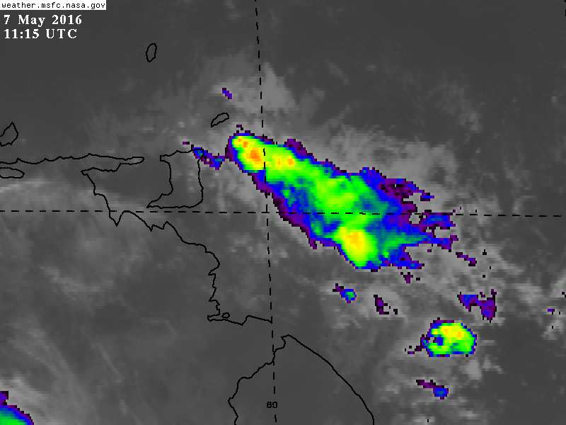
- First True Event
|
- By Ian Martin Borde <readkrox51 at gmail.com>
- Date: Sat, 7 May 2016 08:10:58 -0400
|
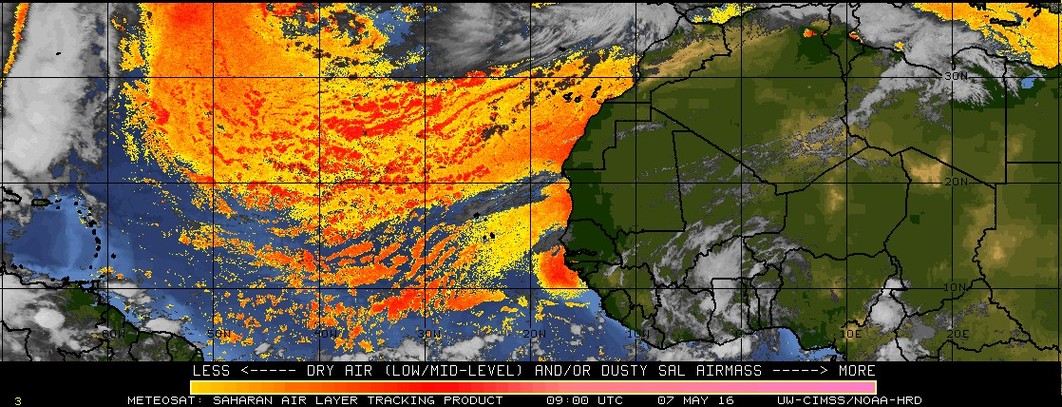
People of Paradise,
Within a few hours, specially for Trinidad and Tobago first of all, We will have a system that resembles the rainy season of June and July and August.
The good part is it will be short - lived. That is the intensity will be short-lived.
Reason: This one will have breeze at times below 32 mph. And seas will be un-friendly.
The above forecast is over 50% probable and endorsed by others. Less forecasted and could prove dangerous, is if after initial impact it spreads and lingers. This is hardly likely !
God bless
Attachment:
7th may 715am.jpg
Description: JPEG image
Attachment:
7th may 2016.jpg
Description: JPEG image
|
|
- For the records, ..., just so you know?
|
- By Ian Martin Borde <readkrox51 at gmail.com>
- Date: Sun, 24 Apr 2016 12:29:11 -0400
|
Just for the records,
"In my opinion, the rainy season has started. My definition is when, the ITCZ instead of dipping south when it reaches 60 - 40 W. Longitude, starts exiting systems north-west."
Apart from all this science, - We had heavy rain fore-day morning Saturday complete with rain flies, (wood ants or termites). -
Without joking now! God Bless! Because it's time to have our boots ready and ourselves informed, ....
Peace, .... |
|
- April Showers
|
- By Ian Martin Borde <readkrox51 at gmail.com>
- Date: Fri, 15 Apr 2016 02:30:43 -0400
|
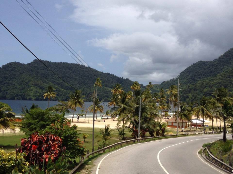
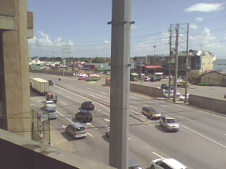
2016-04-15th Fri. 02:10 a.m.
It's a bit early, I know. but even though it's 'early' in a lot of ways, this will be my third post of impending precipitation.
It is really beautiful weather!
Not too dry, not more than a passing shower, Not too hot and humid, not flooding and windy.
Attached is almost 'real-time' what life is like under these beautiful conditions.
God Bless Attachment:
IMG0271A.jpg
Description: JPEG image
Attachment:
IMG0274A.jpg
Description: JPEG image
Attachment:
Port of Port of Spain.jpg
Description: JPEG image
Attachment:
Tobago-Caricom-Fishing Jetty.jpg
Description: JPEG image
Attachment:
North Coast - 'Matelot' - Trinidad & Tobago.jpg
Description: JPEG image
|
|
- Hazardous Variables in Place
|
- By Ian Martin Borde <readkrox51 at gmail.com>
- Date: Sun, 3 Apr 2016 18:22:08 -0400
|
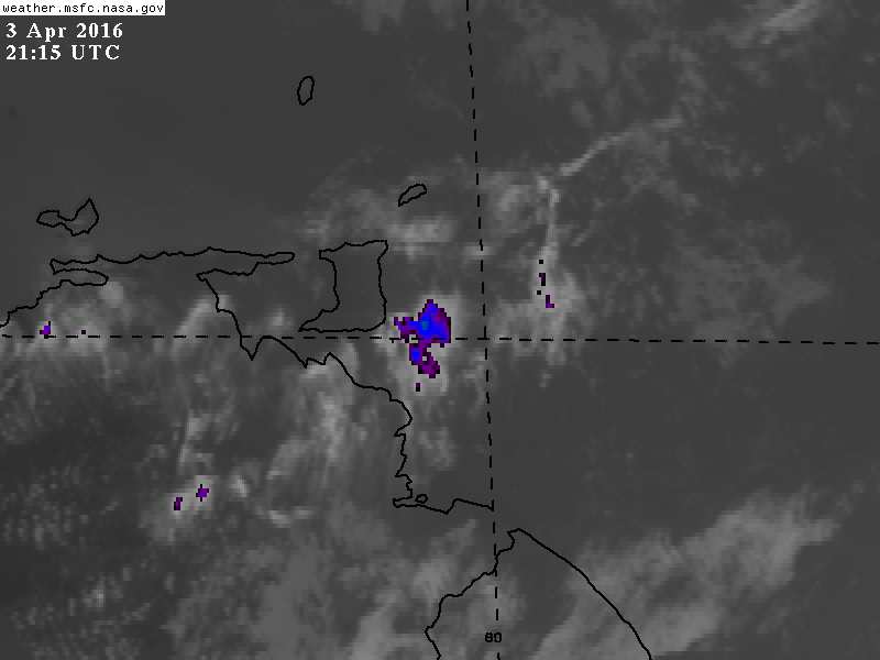
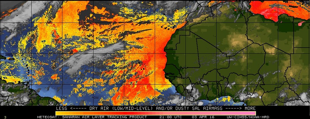
People of Paradise,
There is a more than 30% chance over the next 2 3 days 'hazardous conditions' will arise.
Not just rain, but generally, but it will be on and off, in localized areas.
Once again generally not just the southerly islands.
God Bless Attachment:
3rd April 515pm.jpg
Description: JPEG image
Attachment:
3rd april 2016 2100 UTC.jpg
Description: JPEG image
|
|
- Showers
|
- By Ian Martin Borde <readkrox51 at gmail.com>
- Date: Thu, 31 Mar 2016 05:55:45 -0400
|
2016-03-31st Thu. 05:50 a.m.
There is rain in south and at times and in some places it will be heavy (for a short period).
Time to check our boots and equipment, ...
Attachment:
31st March 515am.jpg
Description: JPEG image
|
|
- Every drop counts, ....
|
- By Ian Martin Borde <readkrox51 at gmail.com>
- Date: Wed, 23 Mar 2016 03:21:57 -0400
|
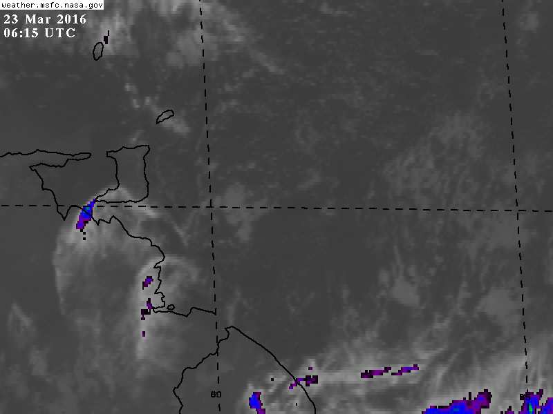
Hi folks,

No good news this time.

We are under water restrictions.
and,
The last 4 - 5 days were
heat-sweltering, drought-invoking days.

The attached image normally means rain.
But, my forecast is,
"The chance of a brief shower in localized areas."

God helps those who help themselves.
Attachment:
23rd march 215am.jpg
Description: JPEG image
|
|
- Phew !
|
- By Ian Martin Borde <readkrox51 at gmail.com>
- Date: Sun, 20 Mar 2016 10:13:43 -0400
|
I apologize for being selfish in my news, But, It is necessary to Thank God and all the fraternity that my sister, Marian Angela Borde and her husband, Peter Jennett, along with their rally team, docked into St. Lucia on Wednesday 16th March 2016 after successfully sailing around the world.
Once again I am extremely relieved (so much I can't describe) and wish her and all her companions the rightful reward due this daunting and praiseworthy accomplishment!
May God bless my sister and all the sailing fraternity of hers.
Thank YOU ! |
|
- Believe it or Not ?
|
- By Ian Martin Borde <readkrox51 at gmail.com>
- Date: Sun, 13 Mar 2016 08:05:01 -0400
|
Petit Valley, Diego Martin, T'dad & T'bgo, W.I. 2016-03-13th. Sun. 07:45 a.m.
Hearty Greetings to all People of Paradise,
Two (02) days ago, before dawn, we had copious rain on and off, from about 2:30 a.m. to 7:00 a.m. I slept through it (quite comfortably) but it's heralding of the 'wet' season was CLEAR from the deposit of fine sand and silt in the driveway and the road out side the property.
Whether you believe the 'wet' season has started or for that matter atmospheric conditions are experiencing a 'climate change', in much less than 36 hours we (in the Eastern Caribbean) will have a recurrence of 'moisture' heavier than two days ago.
It is my firm belief; "There is nothing 'good or bad', simply and naturally what we are in control of and what affects us, IS HOW WE DEAL WITH IT?"
In the height of last year, I read over and over, ... ..., Darwin did not postulate, 'survival of the strongest or brightest' ! But the ability to adapt is not just survival but true development.
God Bless
|
|
- More Moisture - 36 hrs.
|
- By Ian Martin Borde <readkrox51 at gmail.com>
- Date: Sat, 5 Mar 2016 04:25:52 -0400
|
Happy Saturday in Lent, People of Paradise,
There is not much to say in terms of the iguanas, the pets, the garden, the forest and the seas.
But in the skies, at least in the images of the atmosphere, in about 36 hours there is something that is difficult to analyse coming our way.
At least it will be 2 - 4 days of drizzle. If many, many other factors that are natural and some due to climate change persist, it will be 3 days of moisture with a climax somewhere of very heavy rain.
Now, let me go and see if the water tank is full?
God Bless
|
|
- Skewed Seasons
|
- By Ian Martin Borde <readkrox51 at gmail.com>
- Date: Sat, 27 Feb 2016 03:37:09 -0400
|
P/Vly, D'go M'rtn, T'dad & T'bgo, W.I.
2016 - 02 - 27th. Sat. 03:30 a.m.
Good Morning, good day, good night, People of Paradise,
Over the last two days, we have had several drizzles, off and on, short and sweet. Accompanied by a wind factor.
More accentuated than before to forecast, tomorrow and Monday should have actual rain.
Let's not put on boots as yet, as only when it's heavy in the fore-day morning, can we say the wet season is here.
What we can do; is continue to, conserve water and what causes water to fall from the sky.
God Bless
|
|
- Water !
|
- By Ian Martin Borde <readkrox51 at gmail.com>
- Date: Tue, 16 Feb 2016 05:10:35 -0400
|
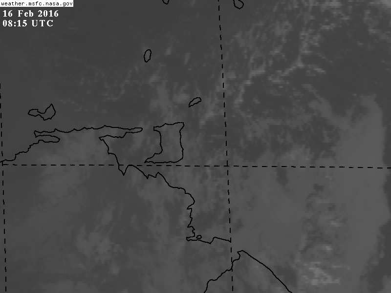
Happy solemn reflection and fasting, People of Paradise,
Only to say,
There is a strong chance of a drizzle or even rain in totality (island wide), within 12 - 24 hours.
( Besides the position of The ITCZ, SAL, there is wind shear. (Quite strong)! )
It only means the sun is trekking it's way back north and we have to look forwards not backwards, ....
God bless
Attachment:
16th feb 415am.jpg
Description: JPEG image
|
|
- Something Small
|
- By Ian Martin Borde <readkrox51 at gmail.com>
- Date: Thu, 4 Feb 2016 02:56:09 -0400
|
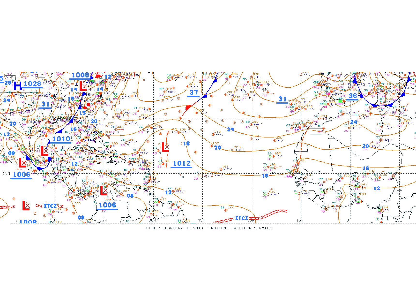
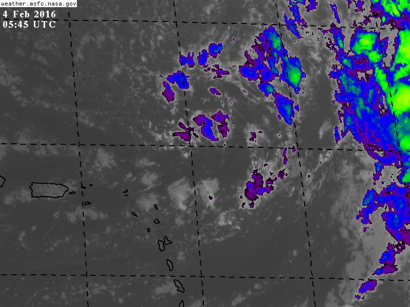
Happy Carnival,
People of Paradise,
NHC Quote: "AN INVERTED TROUGH NE OF THE LEEWARD ISLANDS WILL SHIFT NW THROUGH FRI AS IT WEAKENS THEN IT WILL MERGE WITH THE COLD FRONT SAT. A LOW PRESSURE WILL DEVELOP N OF THE BAHAMAS SAT NIGHT DEVELOPING A NEW COLD FRONT ON SUN."
In my estimation, Waves will be between 8' - 10' ft. for 72 hrs.
Just another small thing to be wary of.
God Bless !
Attachment:
4th feb 00 UTC Atl_Tropics.gif
Description: GIF image
Attachment:
4th feb 145am.jpg
Description: JPEG image
|
|
- Something Small
|
- By Ian Martin Borde <readkrox51 at gmail.com>
- Date: Thu, 4 Feb 2016 02:50:15 -0400
|
|
Happy Carnivnal,
|
|
- Carnival 2016 -
|
- By Ian Martin Borde <readkrox51 at gmail.com>
- Date: Wed, 13 Jan 2016 13:38:31 -0400
|
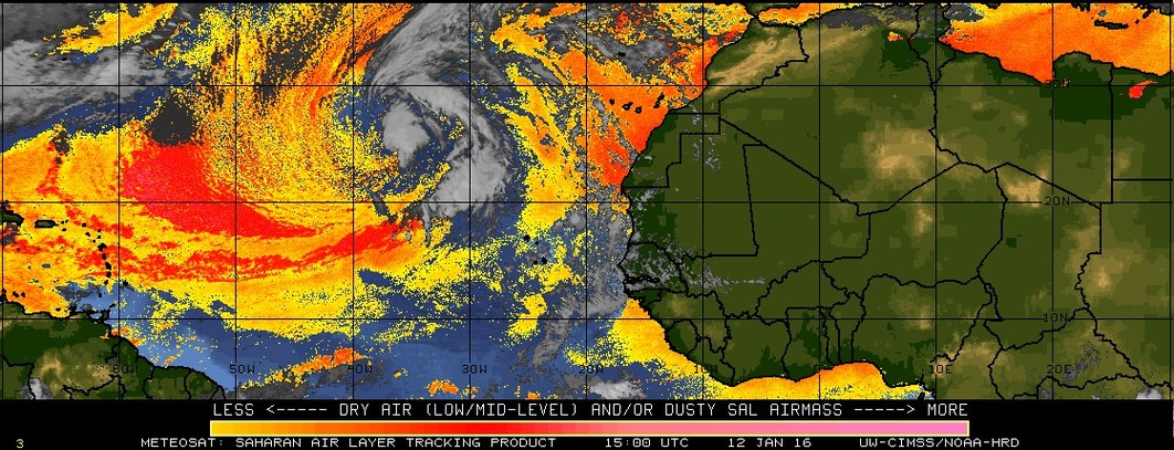
Dear People of Paradise,
Last weekend (check the websites ie. Trinidad Carnival 2016) Carnival 2016 was launched with vintage Carnival.
This weekend the contemporary and qualifying competitors will introduce themselves to be selected as finalists.
Top of this list is what is called,'PANORAMA'. If you have never been to 'Woodstock' this is the next best thing. 'Savannah Party' ! 'One Nation Under A Groove'
You have to be there to understand. With words, it's unbelievable!!!
I also attach better graphics of a phenomenon unfolding, ...
That is the sub-tropical storm.
Until then, Trinidadians are dancing with the devil, ...
Happy Carnival Be safe and sound Attachment:
3rd jan 300 am splitE.jpg
Description: JPEG image
Attachment:
12th Jan 2016 1500UTC reversal in question.jpg
Description: JPEG image
Attachment:
12th jan 2200pm latest72hrs.gif
Description: GIF image
Attachment:
12th jan 2347pm latest72hrs.gif
Description: GIF image
Attachment:
is (1).jpg
Description: JPEG image
Attachment:
is (3).jpg
Description: JPEG image
Attachment:
is (5).jpg
Description: JPEG image
Attachment:
is.jpg
Description: JPEG image
|
|
- 2016 - Plant Trees - 2016
|
- By Ian Martin Borde <readkrox51 at gmail.com>
- Date: Sun, 3 Jan 2016 04:32:48 -0400
|
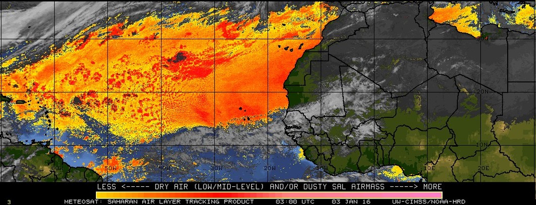
Happy New Year, People of Paradise,
I am sorry. I am very sorry. I apologize.
But if the attached image is not a graphic illustration of Global Warming in action. Then what is ?
It so succinctly illustrates the drought-stricken Caribbean and hurricane - hit Dominica 'climate' we had in 2015.
On a micro-scale, if we started off with one-third of the world's global, mature, discreet, responsible, population to PLANT OR SAVE (10) trees, no matter how small, specially in industrial areas, every week, then my calculated guess is by the end of 2016, the gases below the surface at the bottom of the ocean specially in The Arctic and Antarctica will never be released.
Happy New year, once again Attachment:
3rd jan 300 am splitE.jpg
Description: JPEG image
|
|
- 2016 - Plant Trees - 2016
|
- By Ian Martin Borde <readkrox51 at gmail.com>
- Date: Sun, 3 Jan 2016 04:19:51 -0400
|
Happy New Year, People of Paradise,
I am sorry. |
|
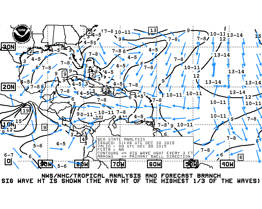
- Seas are Rough
|
- By Ian Martin Borde <readkrox51 at gmail.com>
- Date: Sun, 20 Dec 2015 07:55:25 -0400
|
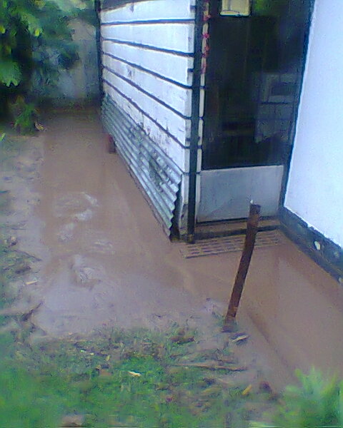
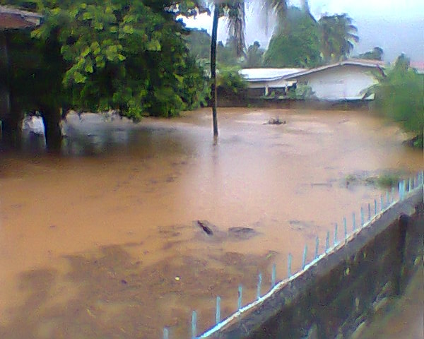
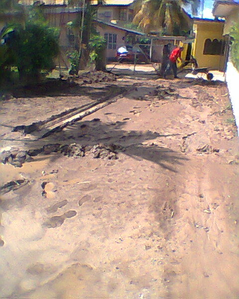
All the best of the season, People of Paradise,
During this Christmas Season, expect -! Seas to be rough !-
There is so much more going on in Paradise, like, what I like best; entertaining good company and having worthwhile conversation, under or without libation, .....
Attached I am going to try and show my house after Isaac. ( as well as Atlantic sea swells )
Merry Christmas
( I am by one of the neighbours in one picture )
Attachment:
atlsea_latestBW.gif
Description: GIF image
Attachment:
Photo0049.jpg
Description: JPEG image
Attachment:
Photo0051.jpg
Description: JPEG image
Attachment:
Photo0052.jpg
Description: JPEG image
Attachment:
Photo0053.jpg
Description: JPEG image
Attachment:
Photo0054.jpg
Description: JPEG image
Attachment:
Photo0055.jpg
Description: JPEG image
Attachment:
Photo0058.jpg
Description: JPEG image
Attachment:
Photo0060.jpg
Description: JPEG image
|
|
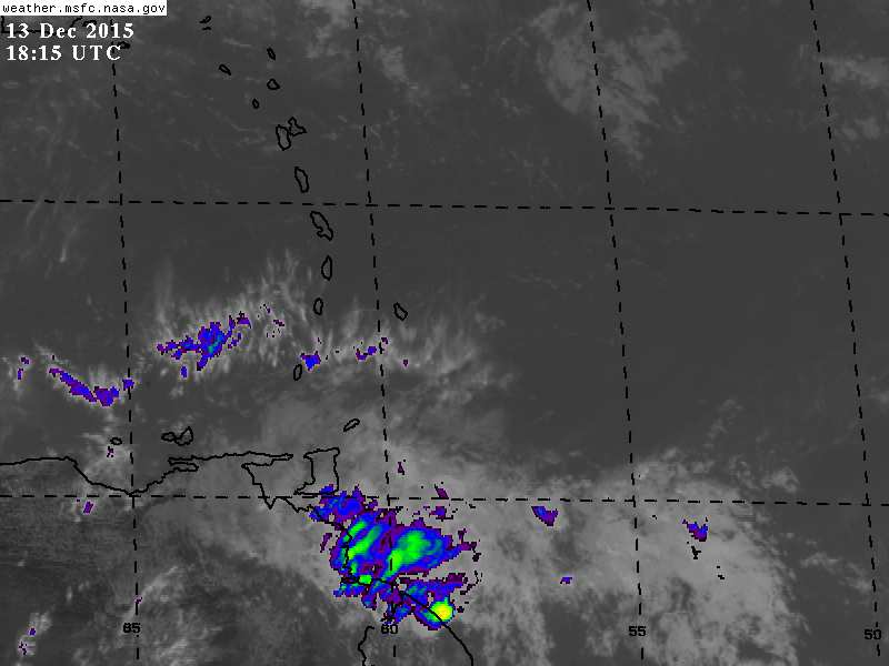
- 20/20 Hind Sight -
|
- By Ian Martin Borde <readkrox51 at gmail.com>
- Date: Sun, 13 Dec 2015 15:19:36 -0400
|
All the best of The Season, All People of Paradise,
It is now ten past three on Sunday 13th December and one hour ago an airmass dropped rain that seemed like drizzle because the rain was falling at a slant on Diego Martin.
I was going to forecast this 2 days ago. BUT IT DEFINITELY HAD AN AIR OF PESSIMISM.
This airmass of moisture has wind and has only now arrived. It will be here for a day and a half, climaxing tomorrow early. It will be a formidable (hazardous) system to South America. I suspect, it's not over for the Lesser Antilles. In other words it has the potential to be hazardous.
Once again it has wind.
God bless
Attachment:
13th Dec (Sun) 215pm.jpg
Description: JPEG image
|
|
- Had to share -
|
- By Ian Martin Borde <readkrox51 at gmail.com>
- Date: Mon, 23 Nov 2015 04:58:32 -0400
|
People of Paradise,
I just saw this and had to share now.
This is as real as it gets.
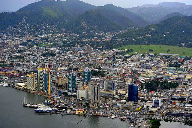
Welcome to Port of Spain 2016, .... Attachment:
Port of Spain 2015.jpg
Description: JPEG image
|
|
- Major Bad Weather approaching, ....
|
- By Ian Martin Borde <readkrox51 at gmail.com>
- Date: Mon, 23 Nov 2015 04:41:05 -0400
|
There is a sizable amount of bad weather approaching after 24 hours before 36 hours.
Once again it is only hazardous if you allow it to be.
Windshear is helping us. But it can work either way. It depends on how we deal with it.
God bless |
|
- Early Year End Celebrations in November
|
- By Ian Martin Borde <readkrox51 at gmail.com>
- Date: Tue, 17 Nov 2015 15:44:20 -0400
|
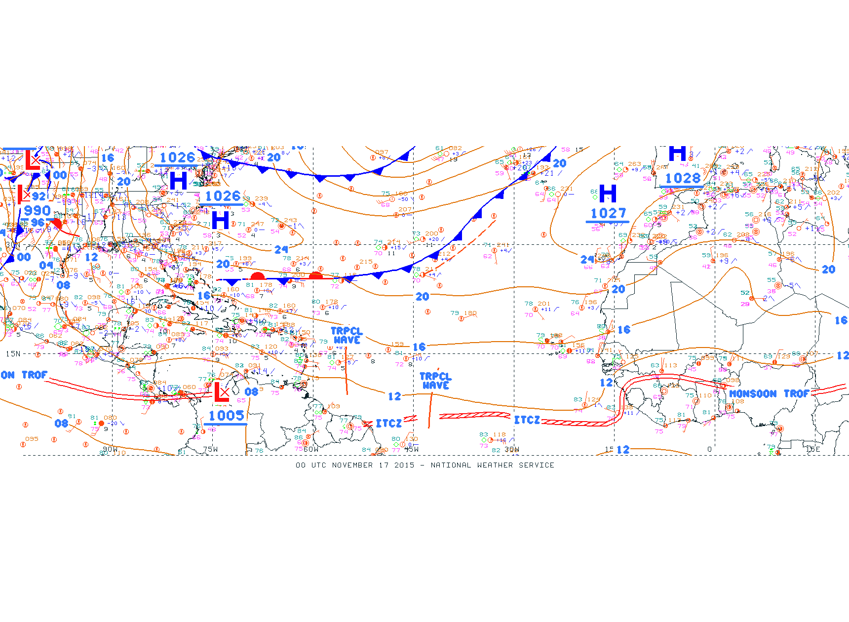
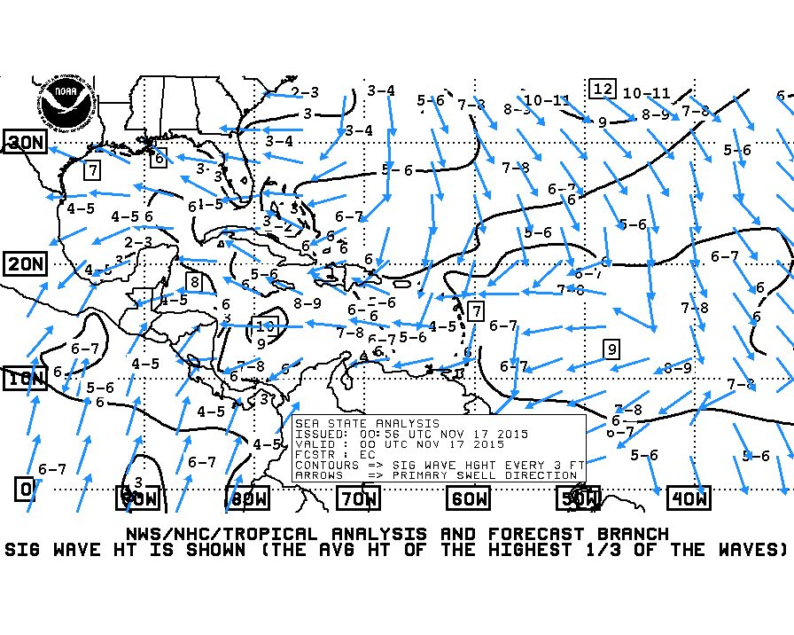
Petit Valley, Diego Martin, Trinidad & Tobago, W.I. 2015-11-17th. Tue. 15:20 (3:20) p.m.
WoW !
People of Paradise,
Are we counting down to the financial year end? Are we counting down to a religious New Year? Or, Are we counting down to the end of the storm season?
I don't talk economics and finance but it was apparent that the Trinidad economy was in a recession or stagnation or depression. As I said I can't talk about those things. But, (for November thus far), First we had commemoration of the dearly departed and Memorial Day. The graveyards were resplendent. Then we had 'Divali' The Festival of Lights. It was the first time for me to witness, but apparently it was celebrated for three days. Now Carnival, I mean Christmas celebrations have started. Give Thanks, ...!
Weather-wise: There is a system to the east in the area of Colombia. To the West, there are two tropical waves. thirdly, based on SAL and wind shear, The ?feeder bands? should pass directly over the Southern Windwards. "It should not be hazardous", but is worth noting.
God Bless
Attachment:
17th nov - Atl_Tropics.gif
Description: GIF image
Attachment:
17th nov - atlsea_latestBW.gif
Description: GIF image
|
|
- Congratulations, you made it !
|
- By Ian Martin Borde <readkrox51 at gmail.com>
- Date: Wed, 4 Nov 2015 04:04:20 -0400
|
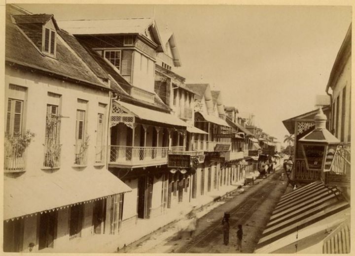
2015 - 11 - 04th. Wed. 03:50 a.m.
Phew !
Definitely a year of extremes, .... Well -- Handled, But, a year of extremes, .... (to be continued, .... )
The ITCZ which conditions may change and probably will, is now a line of wind-shear reaching back to Africa. There will be nothing there for a while.
Congratulations, we pulled thru it ! (Earthquakes and all, .... ) (Kick 'em Jenny), ....
Repeating, ..., conditions are clearing up, not just for today, but for the season.
Next page in the book on atmospheric conditions is wave heights, winter and dew-full roadways and travelling delays and dangers. Very good, ....
(Trying to attach some new pics.) Attachment:
Caribbean by satellite 2015.jpg
Description: JPEG image
Attachment:
fREDERICK sT pORT OF sPAIN BEFORE 1895 FIRE.jpg
Description: JPEG image
Attachment:
North Coast - 'Matelot' - Trinidad & Tobago.jpg
Description: JPEG image
Attachment:
western main road.jpg
Description: JPEG image
|
|
- The Tail End
|
- By Ian Martin Borde <readkrox51 at gmail.com>
- Date: Mon, 2 Nov 2015 02:44:08 -0400
|
People of Paradise,
This is the ignominious tail I spoke of.
To recap: - Storms are not characterized by graphical images or consumer related advertisements and even warnings. - More than one inch ( 1" ) of rain is hazardous. - Consistent (> 90 secs.) breeze more than 27 mph. is hazardous. - The two hazardous items listed above are exacerbated by high tide, waves greater than 2.5 metres, saturated soil and mis-managed drainage.
...TROPICAL WAVES...
TROPICAL WAVE IS ALONG 57W FROM 10N-19N MOVING W NEAR 20 KT OVER
THE PAST 24 HOURS. SSMI TPW INDICATES THE WAVE IS EMBEDDED
WITHIN A SURGE OF MOISTURE. NO ASSOCIATED DEEP CONVECTION.
SCATTERED SHOWERS/ISOLATED THUNDERSTORMS ARE FROM 13N-15N
BETWEEN 51W-54W AND FROM 15N-17N BETWEEN 53W-57W.
Hopefully this should be the last from the Cape Verde area?
Stay safe and sound and It's not a storm, (it's hard to define).
|
|
- Convection will resume within 36 hrs.
|
- By Ian Martin Borde <readkrox51 at gmail.com>
- Date: Thu, 29 Oct 2015 14:32:06 -0400
|
Hi, People of Paradise,
You wouldn't believe how busy I am the last two years since my dearest mom passed away.
Sorry, I always just stick to the point.
The weather is really lovely as Stephen says and Trinidad when bad conditions prevail only damage isolated areas as a rule.
It is sunny and bright! With gentle wafting breezes.
However within 36hrs. we can expect convection to resume and the tail should provide some anonymity and backlash.
Put your boots on tomorrow (early) and don't let it fool you.
God bless
|
|
- Loving the rain in Trinidad
|
- By Stephen Abouhamad <stephen_abouhamad at hotmail.com>
- Date: Thu, 29 Oct 2015 14:01:52 +0000
|
Trinidad and Tobago
Good morning to all the readers of stormcarib. Well these few days I have fallen in love with the weather here in Trinidad. we are seeing frequent afternoon showers with the isolated thunder storm for the past three days in a row. This weather was mainly
caused due to the day time heating and the humid temperatures we have been having at around noon. Even though the ITCZ has made its way south heading into south america and no storms are on the horizon we still need to keep our guard up. You all have a blessed
day in what ever you do.
Regards,
S Abouhamad
|
|
|
- Non-stop S.A. trough - 1st Post
|
- By Ian Martin Borde <readkrox51 at gmail.com>
- Date: Sun, 25 Oct 2015 05:39:23 -0400
|
As a matter of timely information and due process;
A trough emanating from South america has been giving us winds, rain, thunder and lighting since three o'clock, this morning.
There will be some form of damage control, ....
I cannot list the areas I suspect. (Till verification and completion). But from the graphical images, Its the whole island with concentration in the centre of Trinidad.
This definitely warrants a second post, as it is far from finished! |
|
- It's definitely not over, ....
|
- By Ian Martin Borde <readkrox51 at gmail.com>
- Date: Wed, 14 Oct 2015 05:57:07 -0400
|
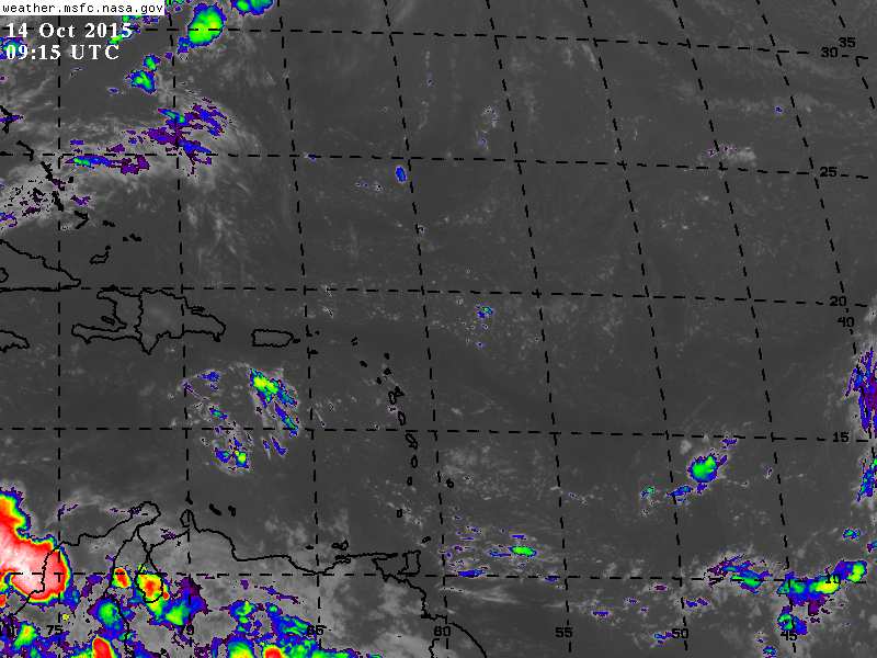
P/Vly, D'go M'rtn, T'dad & T'bgo, W.I. 2015 - 10 - 14th. Wed. 05:40 a.m.
People of Paradise,
We are very vulnerable.
If you have been reading weather discussions, this year is one in three of the new millennium OF EXTREMES, .... (My Interpretation in writing is; "We have become complacent about 'climate change'.") Even if we haven't, "The reversal will be extreme."
There are two systems about 5 days away with spin. At least 'early spin'. (And moving slow.)
Ok, so 'small thing', that happens all the time. No, we have been hit before, and now, We are vulnerable!
TROPICAL WAVE IS IN THE CENTRAL TROPICAL ATLC ALONG 41W/42W FROM
9N-18N MOVING W NEAR 10 KT OVER THE PAST 24 HOURS. THE 700 MB
STREAMLINES SHOWS THE WAVE WITHIN AN INVERTED TROUGH AND SSMI
TPW IMAGERY DEPICTS THE WAVE EMBEDDED WITHIN A MOISTURE SURGE.
CLUSTERS OF SCATTERED MODERATE/ISOLATED STRONG CONVECTION ARE
FROM 11N-18N BETWEEN 36W-42W.
Please, please, please, stay posted and prepared, .....
[Note: In the attachment watch the curve of the moisture in the south - eastern corner.]
Attachment:
14th oct 415am.jpg
Description: JPEG image
|
|
- TW - 24 hrs.
|
- By Ian Martin Borde <readkrox51 at gmail.com>
- Date: Mon, 12 Oct 2015 14:58:58 -0400
|
Good Day, Good Everything, People of Paradise,
It is around 3:00 o'clock this afternoon, and my best bet is we will have rain tonight. To quote, "... with a deep moisture surge, ..."
It does seem to be more hazardous than the last one which affected Tobago for the good and bad.
However by no definition whatsoever, will it be stormy.
A TROPICAL WAVE IS OVER THE CENTRAL TROPICAL ATLC WITH AN AXIS
THAT EXTENDS FROM 16N52W TO 08N56W MOVING W AT 15 TO 20 KT OVER
THE PAST 24 HOURS. THE 700 MB STREAMLINES SHOW THE WAVE IS ALONG
AN INVERTED TROUGH AND SSMI TPW IMAGERY DEPICTS THE WAVE
EMBEDDED WITHIN A DEEP MOISTURE SURGE. SCATTERED MODERATE
CONVECTION IS FROM 07N TO 12N BETWEEN 48W AND 61W.
Stay safe and sound |
|
- Cistern-Filling Rain, today and tomorrow!
|
- By Ian Martin Borde <readkrox51 at gmail.com>
- Date: Thu, 8 Oct 2015 05:23:37 -0400
|
People of Paradise,
I have been very busy in 2015 and my age and health is not helping the situation. Sorry if my posts are not the usual.
The rain we should get today and tomorrow will or should not be 'hazardous'. But please don't do anything stupid and remember those affected.
(One of many reasons, it is moving over 15 knots westwards.)
However it is a combination of three systems and will bring relief to all drought-stricken areas. (Everybody will get copious rain.)
Given a positive outcome and authorization, I will share what 2015 is doing to me.
Believe me, it's all 'good'.
God Bless ! |
|
- Bunker Down !
|
- By Ian Martin Borde <readkrox51 at gmail.com>
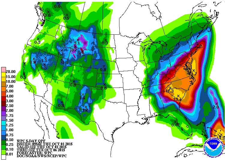
- Date: Fri, 2 Oct 2015 06:29:15 -0400
|
The thoughts and Prayers of The People of Paradise are united to our fellow citizens of The Northern Caribbean (Greater Antilles) and The USA, (East coast).
'Joaquin' and The Northern Caribbean are outside of my ability.
Hence the only forecast I can give or ask you to pay heed to is the graphic attached. (Which is constantly changing and unpredictable).
So, Going back to basics,
Hunker Down and pay MAXIMUM Heed to AUTHORITIES, ... !!!!!
STAY 'SAFE AND SOUND',
Attachment:
3day-wpc-12Z-10.1.15.jpg
Description: JPEG image
|
|
- ITCZ Returning, ....
|
- By Ian Martin Borde <readkrox51 at gmail.com>
- Date: Fri, 25 Sep 2015 07:52:42 -0400
|
Good Day, Good Everything, People of Paradise,
Isn't it lovely !
That is some fine weather !
Okay! Now it appears whether Ida and all fore-runners go south-west or north-east that dance at 40W. is abating to give way to the ITCZ - and a continuation of a train of events. We still have time to enjoy the early weekend as it should not return till 48 - 72 hrs.
Whether the precipitation will be light or heavy, accompanied by refreshing gusts, No one can tell?
I interrupted just to say that it is the unguarded moment that proves to be the faite fatale.
So I for one (and others) will be putting back on our boots.
Keep your guard up, and God bless
|
|
- Interesting Scenario
|
- By Ian Martin Borde <readkrox51 at gmail.com>
- Date: Thu, 17 Sep 2015 05:07:23 -0400
|
D'go M'rtn, T'dad & T'bgo, W.I. 2015 - 09 - 17th. 04:45a.m.
Ah! the pleasure of Paradise,
Good Day, Good Everything,
Tonight and Tomorrow, just like a full moon unveils a scenario for storm trackers and disaster operators! TD 9 and 95L with either meet or but definitely affect each other at 40 W. 40 W. is the place to be tonight.
However the most important thing now to get across is that we all need rest, .... Rest from snacks, backgammon, scrabble, crosswords, texting, and all that we have been doing indoors and get out! Get out and picnic, by the river, (Yes!) by the sea, in the parks, ....
Because for the next 5 - 7 days TD 9 and 95L are going to make things hot, hot, hot ! (And we need it.)
Thought : "While life is journeying between two extremes, human frailty and 'getting caught up' is not only human but necessary."
Enjoy yourselves Attachment:
cARIBBEAN sEA.jpg
Description: JPEG image
|
|
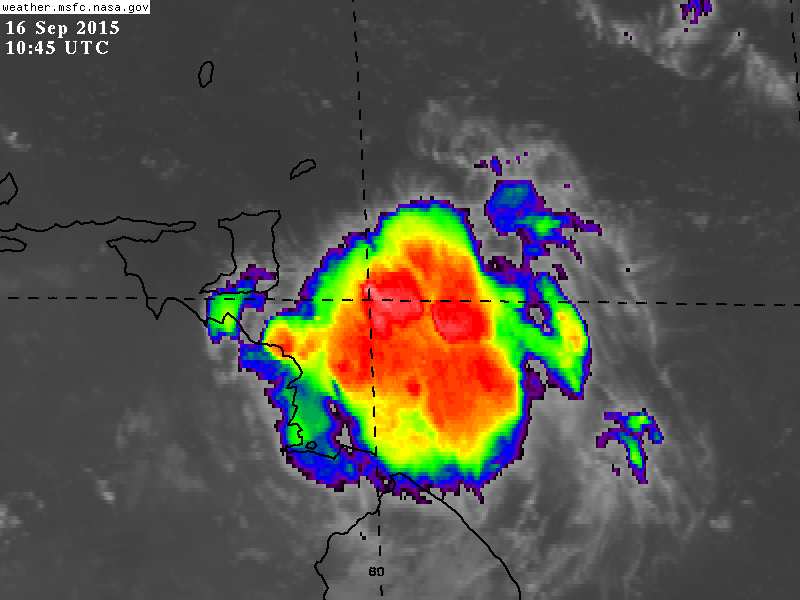
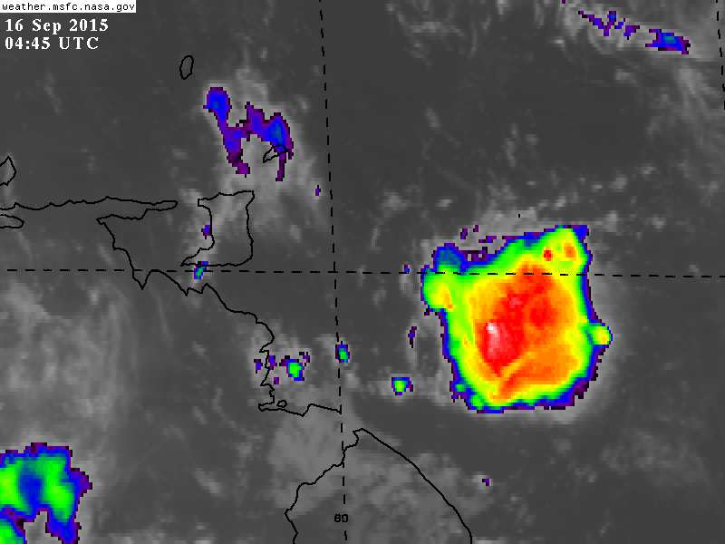
- Brace Trinidad & Tobago
|
- By Ian Martin Borde <readkrox51 at gmail.com>
- Date: Wed, 16 Sep 2015 07:29:42 -0400
|
I am extremely busy, save to give out this small piece of information.
I can't believe none else is telling anybody about it. Attachment:
16th sept 645 am.jpg
Description: JPEG image
Attachment:
16th sept 1245am.jpg
Description: JPEG image
|
|
- Let's get REAL as One !
|
- By Ian Martin Borde <readkrox51 at gmail.com>
- Date: Sat, 12 Sep 2015 07:34:51 -0400
|
People of Paradise,
I am not going to attach pictures. I am not going to be more dramatic than that ! I am not going to say anything political.
Caveat: Without advertisement, my opinion is highly respected.
Imagine: We did not have SAL (dry-air) and wind shear and 'El Nino'. Imagine another low pressure system is 72 hours away. Imagine we had three systems (minimum) affecting us already.
Why do I feel like a contraband vigilante, or undercover writer doing somebody elses job, When the right procedures and systems, input and output, feedback, have not been done and could have been done.
When I end in 'God Bless', the other part is, 'You do The Rest, ...' !
|
|
- Reaction Time -
|
- By Ian Martin Borde <readkrox51 at gmail.com>
- Date: Thu, 10 Sep 2015 05:35:02 -0400
|
T&T,W.I. 10-09-15 05:20a.m.
It is too early to sound any foreboding alarms. Given that 'Grace' is; - less than 100 miles in diameter. - winds are less than 40 mph. - there is no significant convection as yet.
- the greatest threat to 'Grace's' survival lie just ahead.
but I will type a few words.
'Grace' is less than 36 hours away from landfall. If as in weather anything can happen and precaution and prevention is better than cure.
Then three things obtain, ... Those that are trepid should return to emergency shelters and safe havens. Secure all loose material and debris from being blown about. Harbour expensive equipment. and, Lastly stay calm, and do not venture out tonight, tomorrow and tomorrow night.
God bless The commonwealth nation of Dominica.
God bless us all Thank You, Lord!
|
|
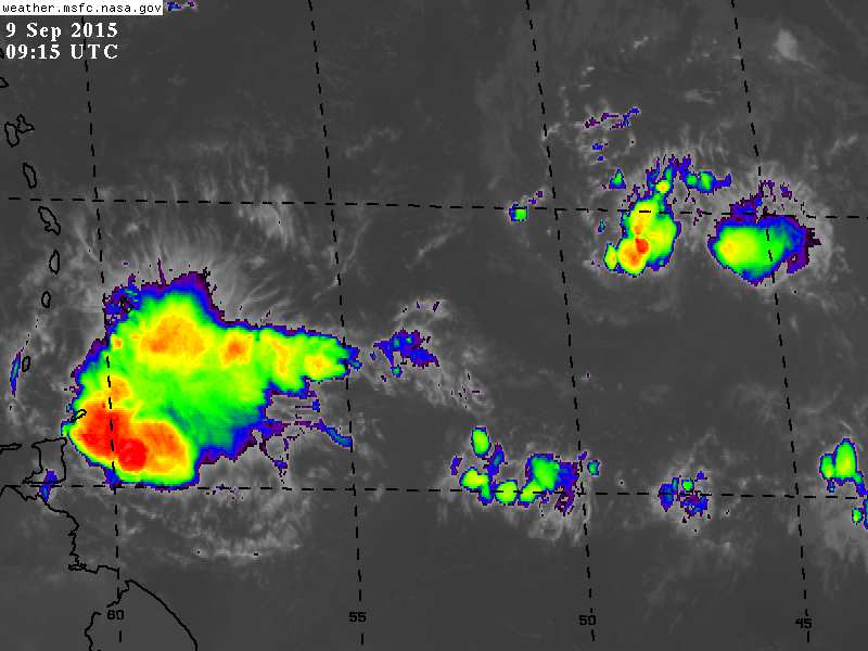
- Phew !
|
- By Ian Martin Borde <readkrox51 at gmail.com>
- Date: Wed, 9 Sep 2015 05:59:39 -0400
|
I was trying to get a rest from alot of things including the misfortune of 'Erika'.
When I saw this!
Help us, Lord ! Attachment:
9th sept 515am.jpg
Description: JPEG image
|
|
- 'Grace' -
|
- By Ian Martin Borde <readkrox51 at gmail.com>
- Date: Sun, 6 Sep 2015 05:32:19 -0400
|
Today, Here and Now, .....
Good Morning, Good Day, Good Night, People of Paradise,
The 'blob' called 'Grace' is expected to make landfall Friday,11th. September 2015.
Today is today. So I have attached two pictures of something I depend on others to explain to me. Because I am not joking. I really am ignorant.
They are photos of SAL and Wind Shear pertinent to today.
God Bless and Forgives
Attachment:
6th Sept 0600 UTC SAL.jpg
Description: JPEG image
Attachment:
6th Sept 2015 wind shear.GIF
Description: GIF image
|
|
- Small Surprise - 72 hrs. -
|
- By Ian Martin Borde <readkrox51 at gmail.com>
- Date: Fri, 4 Sep 2015 01:39:09 -0400
|
2015 - 09 - 04th. Fri.
Condolences
The most sincerest and heartfelt condolences go out to the Families of Victims and All in General, involved or remotely concerned with the passage of 'Erika', Wednesday 26th. and Thursday 27th. August 2015 in Dominica, ....
"We have all been affected."
On the plus side, we pray to Almighty, Everlasting, All Merciful and Beneficent God, to continue giving 'us' a 'Spirit of newness'. This Divine Gift, while with heavy hearts and weary hands but an absolved spirit we bury 'The Dead'. Who are by no means dead because they live on in this Holy Spirit, for all of us. Will take us to a brighter tomorrow.
Weather wise: A TROPICAL WAVE IS MOVING ACROSS THE CENTRAL ATLANTIC WITH AXIS
EXTENDING FROM 16N48W TO 08N45W...MOVING W AT 5-10 KT. THE WAVE
COINCIDES WITH A BROAD 700 MB TROUGHING BETWEEN 47W-51W. SSMI
TPW INDICATES THE WAVE IS EMBEDDED WITHIN A SURGE OF LIGHT TO
MODERATE MOISTURE WHICH IS BEING HINDERED BY SURROUNDING SAHARAN
DRY AIR AND DUST. WITH THIS...NO SIGNIFICANT CONVECTION IS
PRESENT ALONG THIS WAVE. This wave just exited the ITCZ, which is at 0 - 5 N. Latitude and the wave is at 12 N. 45 W.
I know absolutely nothing about wind shear and SAL but a haphazard guess is that there is less resistance to spin formation from today.
May their souls, ~ Rest In Peace ~
|
|
- Sunrise - A New Spirit -
|
- By Ian Martin Borde <readkrox51 at gmail.com>
- Date: Fri, 28 Aug 2015 03:11:02 -0400
|
 |
|
- Sunrise Tomorrow - A New Day / A New Spirit -
|
- By Ian Martin Borde <readkrox51 at gmail.com>
- Date: Fri, 28 Aug 2015 00:10:03 -0400
|
D'go,T&T, W.I. 27th/08/15 11:50 p.m.
Four (04) hours after the complete passage of Erika', should bring us, by my reckoning, to sunrise. And the sun will rise. We are being helped as I type and once again, health permitting, I will be up all night. Tangible relief efforts begin with each and everybody's help at sunrise in the morning!!!
Tonight, we have got to plan. Before we prepared. Tonight we do a stock check and a stop check, because tomorrow, "Once I remembered shoveling for 10 hours straight."
High Energy Work without Planning, is counter-productive and Panic.
Re-establish communications, don't help without verification and compliance. Beef-up tools and equipment. Re-enforce rules and laws.
Whatever is the individual plan, have backup, rest and relief available or don't start without help or on your own. Don't make a bad situation, worse.
Standing by
|
|
- Please, don't venture (out or anything), ... !!!!!
|
- By Ian Martin Borde <readkrox51 at gmail.com>
- Date: Thu, 27 Aug 2015 10:41:27 -0400
|
Listen to The Authorities, .... Don't despair or Panic but PRAY , . . . . Stay indoors at all costs, ..., - BUT ASK FOR HELP - Stay indoors until 4 hours after the complete passage of the storm. If sequestered, move to an emergency shelter without complaining or criticizing.but be proactive and complimentary.
Nothing is important now, ( imagine toxicity around you ), nothing but your breathing, heart beat and blood circulation is important.
Boil water or add chlorine. Ask authorities? Leave fallen fruits and dead animals alone.
Feel free to safeguard children and less fortunate.
God Bless !!!
Not everyone is qualified to deal with this. Understand that ! |
|
- Solidarity
|
- By Ian Martin Borde <readkrox51 at gmail.com>
- Date: Thu, 27 Aug 2015 08:09:31 -0400
|
I am here. and I will be here,
Till everybody is safe and sound.
Attachment:
515am 27th aug.jpg
Description: JPEG image
|
|
- To: Dominica
|
- By Ian Martin Borde <readkrox51 at gmail.com>
- Date: Thu, 27 Aug 2015 04:55:04 -0400
|
Antigua, Barbuda, Montserrat, Guadeloupe, Martinique, St. Lucia and St. Vincent, you are not left out!!!!!
Dominica the centre is passing over you instant.
It appears an eye will form on the western exit area off Dominica.
FOR NOTHING IN THE WORLD
GO OUTSIDE WHEN THE CENTRE PASSES.
That's where the wind is, ...
|
|
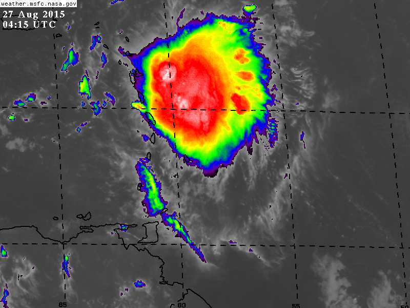
- PRAY - Impact - PRAY
|
- By Ian Martin Borde <readkrox51 at gmail.com>
- Date: Thu, 27 Aug 2015 01:08:51 -0400
|
I will be up all night praying and watching.
I am definitely invited to help afterwards.
It is much more organised, I would say just less than hurricane strength. An allegory to give you advice will be, ... "All who were under stormwatch are now under storm warning with Impact underway."
Pray, pray, Pray, ..... Attachment:
27th aug 0015am.jpg
Description: JPEG image
|
|
- Scattered Notes and Summary -
|
- By Ian Martin Borde <readkrox51 at gmail.com>
- Date: Tue, 25 Aug 2015 20:58:34 -0400
|
2015 - 08 - 25th. Tuesday T'dad & T'bgo, W.I. 20:35 (8:35) p.m.
Good Night, Good Day, Good Everything, to We People of Paradise,
This is two part but all is a scattered summary of effects and affects, .... (Which in no way I deserve the courtesy of Dave and Gert, along with my much admired ladies like Martha and Isabel, ....) Please donate, ....
- Anyhow one takes it the seas will be dangerous. (Yes, I used the word dangerous.) - We can't thank God fully as yet for 'Danny' because he cleared up SAL, WHICH IS BAD - for 'Erika' and the others. - This is not 'Danny'. a) It's survival chances are much greater and deadlier. b) It is bigger and if it slows down. God help down the road. c) The dwarfs and feeder bands are more pronounced.
Talking about feeder bands, I base the rest of my input on an outlandish supposition, ...
It inverted (as hurricanes do when they exit the ITCZ) at 50 W. outside of the ITCZ. This must mean something? The tail or feeder bands turned from SE. to NW. and are now North to South. or trying to be, depending on eventual direction / path.
It could slow down. It is trying to form the eye after inversion. It will not stay the same. Either break up or get more organised.
Then again who knows,
"Don't count your grapes when they are in the wine-press."
Attachment:
Erika effects on Impact.gif
Description: GIF image
|
|
- Stay Indoors and Await Word from The Authorities !!!!!!
|
- By Ian Martin Borde <readkrox51 at gmail.com>
- Date: Sat, 22 Aug 2015 21:54:53 -0400
|
[Eastern Caribbean Interests] : If you follow the very graphical representation of 'Danny' attached, you will see, .....
ALL EASTERN CARIBBEAN INTERESTS SHOULD GO INDOORS
and await word from the authorities, ... !!!!!!!!!! - It is now headed due west.
- It's moisture has reached.
- Breaking up into feeder bands for the next three days
means it has enlarged.
Attachment:
rbtop_lalo-animated.gif
Description: GIF image
|
|
- Update -
|
- From: Ian Martin Borde <readkrox51 at gmail.com>
- Date: Fri, 14 Aug 2015 08:39:23 -0400
|
Please receive the two attachments.
Precipitation for all of The Eastern Caribbean.
Hazards for St. Vincent, Dominica and Tobago.
Impact! Attachment:
14th aug 545am.jpg
Description: JPEG image
Attachment:
14th aug 745am.jpg
Description: JPEG image
|
|
- Hot Hot Hot!!
|
- From: Stephen Abouhamad <stephen_abouhamad at hotmail.com>
- Date: Thu, 13 Aug 2015 04:45:39 +0000
|
San Juan
Trinidad
Good Morning to all,
These days in Trinidad I have to say have been extremely hot and sticky with high humidity levels. Please make sure and drink lots of water throughout the day and keep cool. Looking at the satellite map we can see more dry conditions for the forecast in
Trinidad and Tobago. Lots of dry air as well. This proves that's its been a slow start to the hurricane season. But we got still keep our eyes open.
Regards,
S Abouhamad
|
|
|
- Another one in train, ...
|
- From: Ian Martin Borde <readkrox51 at gmail.com>
- Date: Wed, 12 Aug 2015 17:26:55 -0400
|
Petit Valley, Diego Martin, Trinidad & Tobago, W.I. 2015-08-12th. Wed. 17:20 (5:20) p.m.
Here again, People of Paradise,
We have another blob in train. It's of note because it's exiting the ITCZ at 50 W. 10 N. at 2:00 p.m. today.
It's barely discernible just like the others. It is bombarded with SAL (dry air) just like the others. It is barely visible because of the jet stream.
However as we know I write as best as possible when it's 36 hrs. away.
(Haven't taken of my boots as yet!)
God Bless
|
|
- Just for Southerly Islands
|
- From: Ian Martin Borde <readkrox51 at gmail.com>
- Date: Sun, 9 Aug 2015 16:58:27 -0400
|
Well People of Paradise the last blob sure did fizzle out after reinvigorating a dry scene.
Trinidad and Tobago and maybe a few more can expect similar weather, (more rain), tomorrow. Maybe early tomorrow.
This is due to a combination of factors, including the jet stream. (Ever wondered what happened to all that moisture it dispersed.)
Leaves me to say what goes around, comes around.
God bless |
|
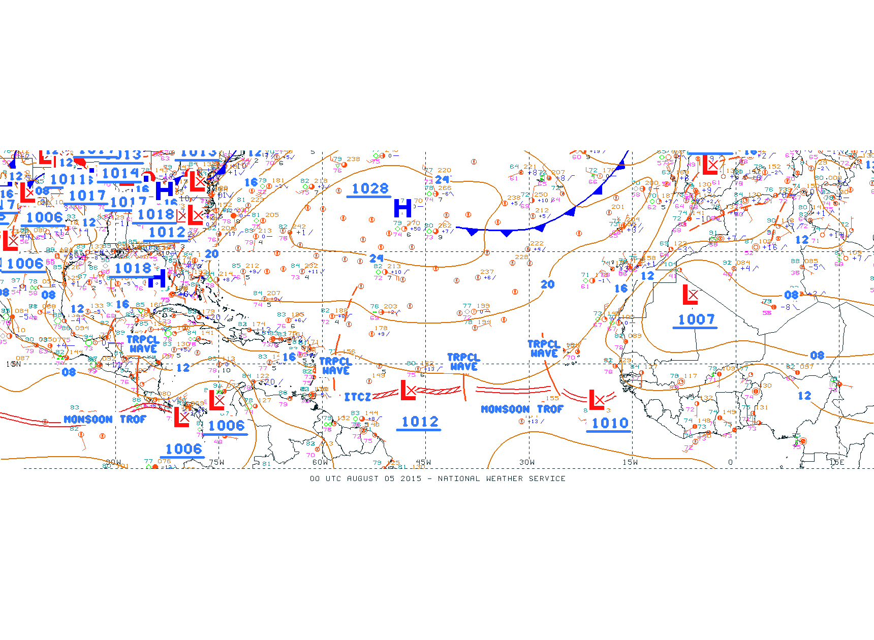
- Impact - 48 hrs. -
|
- From: Ian Martin Borde <readkrox51 at gmail.com>
- Date: Thu, 6 Aug 2015 11:39:09 -0400
|
People of Paradise,
Please don't focus on me or my posts, or satellite images, or fashionable conversation, panic buying, denial or over optimism.
Preparing to protect life and limb is or should be a daily routine to teach, as much as catching a fish. Dangers are part of life.
It is not paranoia.
It is a tradition of our forefathers that has to handed down.
It is the history of survival.
God bless Attachment:
00 UTC August 05 2015.gif
Description: GIF image
Attachment:
4th august 215pm.jpg
Description: JPEG image
Attachment:
06th august 200am.gif
Description: GIF image
Attachment:
6th august 1015 am.jpg
Description: JPEG image
|
|
- Four Pics of Fauna and Additional Confirmation
|
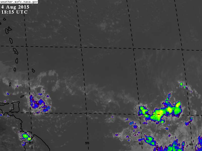
- From: Ian Martin Borde <readkrox51 at gmail.com>
- Date: Tue, 4 Aug 2015 15:12:40 -0400
|
Please receive four photos to add to previous posts.
[Notice the Longitude and Latitude.] [The one previous also dipped south twice.] Attachment:
4th august 215pm.jpg
Description: JPEG image
Attachment:
IMG-20150729-WA0044.jpg
Description: JPEG image
Attachment:
IMG-20150729-WA0045.jpg
Description: JPEG image
Attachment:
IMG-20150729-WA0046.jpg
Description: JPEG image
|
|
- Trying to Understand - SAL (+ High-Level Affects in Global Warming)
|
- From: Ian Martin Borde <readkrox51 at gmail.com>
- Date: Tue, 4 Aug 2015 05:39:09 -0400
|
People of Paradise,
Can you imagine we are in August of the year 2015. It's 5:15 a.m. and everyone expects another normal sunny day in Paradise. My one and only child if she lives to over 100 years old will survive three centuries.
Well folks, sad to say, it is not so. Yesterday besides 'Saragossa' weed making the Tobago beaches unbathable, We had rain, maybe on and off, but disruptive rain out of nowhere whole day. I wonder if mosquitoes are planning a new chemical warfare attack. Animals and birds that were in deep forests before, cross the streets and are in plates, if not pets. We don't only have drought, nobody is able to give a clear forecast. I could go on but will end by saying, "Marine life was the first to go."
There is a blob with already spin and adequate moisture exiting the ITCZ after 40 W. Longitude which is a decisive time. In addition: - The route of this blob in 36 - 72 hrs. is clearing up of SAL. - Normally blobs are surrounded by SAL. The SAL that affected this blob so far is now surrounded by moisture. - After 40 W. if it breaks ITCZ, spin or no spin, it's a refreshing blob.
God Bless |
|
- Weak Tropical Blob - Tonight and Tomorrow
|
- From: Ian Martin Borde <readkrox51 at gmail.com>
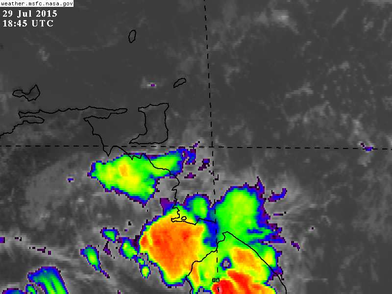
- Date: Wed, 29 Jul 2015 15:23:01 -0400
|
A weak, rapidly moving but hazardous blob is going to affect us. (instant).
It should not be underrated and though not clearly visible will affect the entire eastern Caribbean.
Stay safe and sound Attachment:
29th july 245pm.jpg
Description: JPEG image
|
|
- Kick 'em Jenny alert lowered to Yellow
|
- From: Katy Young <katy at sbms.co.tt>
- Date: Sun, 26 Jul 2015 11:38:20 -0400
|
Kick 'em Jenny alert lowered to Yellow
NADMA Press Release - Kick 'em Jenny Alert Lowered to Yellow
Jul.26.2015
NATIONAL DISASTER MANAGEMENT AGENCY (NaDMA) Grenada - The Seismic
Research Centre (SRC), University of the West Indies has reported that
the activity levels at the Kick-‘em-Jenny under water Volcano has
reduced significantly during the last 48 hours. Since 6:00 p.m., on
Saturday July 25th, no activity was recorded.
On Saturday, July 25th at around 5:50 p.m., a team including a
Volcanologist from the SRC, Grenada’s Acting National Disaster
Coordinator, and a camera person, participated in a fly over of the
Kick-‘em-Jenny area by helicopter. The volcanologist, Dr. Frederic
Dondin, who has conducted extensive research on Kick-‘em-Jenny,
concluded, after his observations, that there was absolutely nothing
unusual in the area. Based on the above findings, and given the
fact that the activity levels at Kick-‘em- Jenny has diminished, the
Government of Grenada, based on the advice of the SRC has lowered the
alert level to YELLOW with immediate effect. The YELLOW alert
level means that vessels should observe a 1.5 km exclusion zone.
However, as a precautionary measure, the marine community is advised to
continue observing the 5 km exclusion zone.
Stay safe all Katy
|
|
- Touch-down, ....
|
- From: Ian Martin Borde <readkrox51 at gmail.com>
- Date: Mon, 20 Jul 2015 08:46:09 -0400
|
Well folks,
The dust-buster blob has touched down, at least the outskirts of it, at 7:12 a.m. in Trinidad and Tobago. Tonight is going to be 'wet'. We are having intermittent showers, non-hazardous in nature presently. God bless Attachment:
20th july 745am.jpg
Description: JPEG image
|
|
- Blob Moving Across The Atlantic
|
- From: Stephen Abouhamad <stephen_abouhamad at hotmail.com>
- Date: Fri, 17 Jul 2015 03:21:04 +0000
|
Trinidad and Tobago
Good Night To All,
Its been a while since I posted but there is something that grabbed our attention. A couple hundred miles away from the Caribbean is the first real sign of Tropical activity as a Tropical Wave has a low pressure system and its slowly gathering strength.
The National Hurricane Center is giving this wave a 10% chance for further development. Its something for all countries to keep an eye at as the wave shows signs of getting stronger. Hope all is well and enjoying the C.P.L throughout the Caribbean.
Shout out to my #Favorite French Girl Petula from Dominica (From Mr Trini)
Regards,
Stephen and Michael Abouhamad
|
|
|
- Semi-Significant Blob - (8 - 48 hrs.) -
|
- From: Ian Martin Borde <readkrox51 at gmail.com>
- Date: Thu, 16 Jul 2015 03:52:33 -0400
|
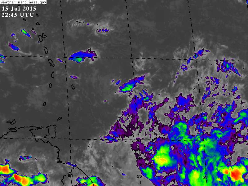
Petit Valley, Diego Martin,
Trinidad & Tobago, W.I. 2015-07-15th. Thu. 03 : 30 a.m. People of Paradise, The much-needed and much-anticipated moisture/precipitation should have reached some localities already. My analyses while only are for Trinidad & Tobago, incorporate, by nature, islands lower than Guadeloupe and up to The ABC islands. We have had quite a crop of mangoes and guavas and paw-paws, and even though more fortunate in the rain department, the month long ripening of the golden apples which never ripened keep us close to our drought-stricken neighbours. One can easily generalize and say, Global-Warming still exists even though, atmospheric patterns are normalizing and are more predictable in the norm. It's much too early, but about 5 days away at 38 W. Longitude There is a blob which will be the strongest yet to battle SAL and wind-shear. I am predicting discernible circular motion at 58 W. in 5 days time. While it is too early to even do what I just did; The fact is, the biggest one is 5 days away. (And it's not going to turn south.) Keep your boots on and umbrellas handy while helping the less fortunate, God Bless Attachment:
15th july 645pm.jpg
Description: JPEG image
|
|
- The subsequent post ( of three threatening blobs) -
|
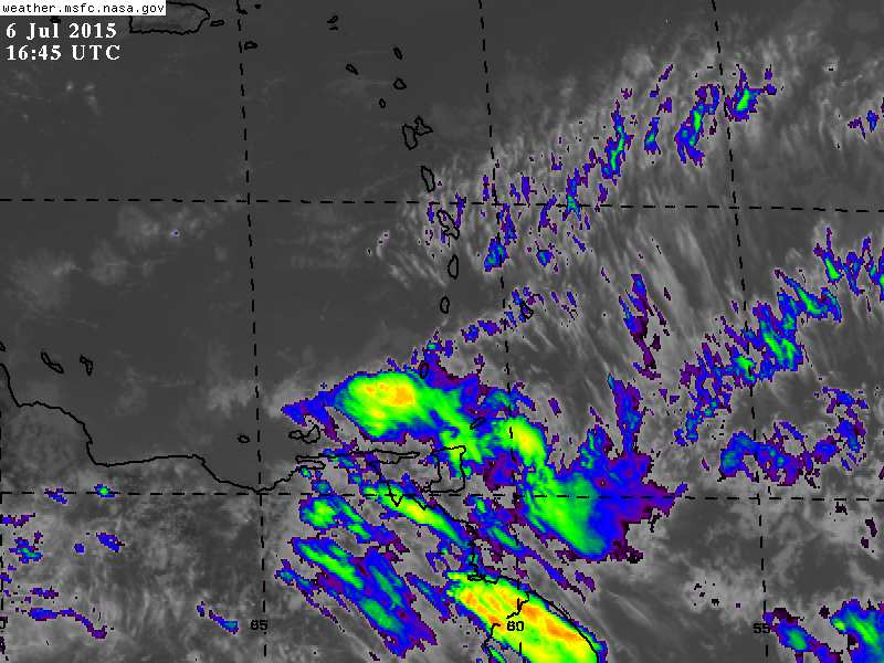
- From: Ian Martin Borde <readkrox51 at gmail.com>
- Date: Mon, 6 Jul 2015 13:25:21 -0400
|
The main part of what I experienced and spoke about before
has reached the eastern Caribbean.
While tempered by SAL (Dry Air) and high level currents, it is my experienced opinion it's still hazardous. We have a mixture of whiteout and blackout for two days now! Maintain vigilance, .... Attachment:
6th july 1245pm.jpg
Description: JPEG image
|
|
- Pre-Cursor to Circular Movement - 12 - 48 hrs. - albeit SAL
|
- From: Ian Martin Borde <readkrox51 at gmail.com>
- Date: Sun, 5 Jul 2015 04:23:02 -0400
|
Petit Valley, Diego Martin,
Trinidad & Tobago, W.I. 2015-07-05th Sun. 04 : 05 a.m. Belated, 4th July, People of Paradise, Independence Day this year is noteworthy for the fact that, females are in the forefront and are becoming more and more independent. And the voice of minority groups are gaining representation more and more. A forward-progression blessing, .... At 1:45am. tonight, I woke to see if outside was flooding. Not being sensational at all, in the true vein of disturbances, it came out of nowhere. Or rather SAL (Dry - Air). The attached picture tells it all and it's getting worse. I'm on standby. Satellite images suggest Impact has not arrived and will happen in 12 - 48 hrs. But at 2:00 am. we Trinidadians had to be first in the party. All this requires a subsequent post. Standing by God bless Attachment:
5th july 315am.jpg
Description: JPEG image
|
|
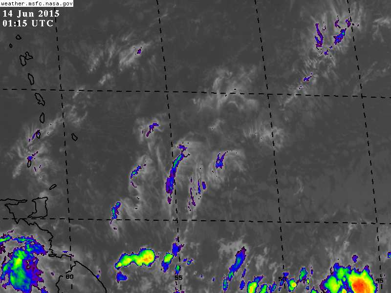
- 2nd. Blob -
|
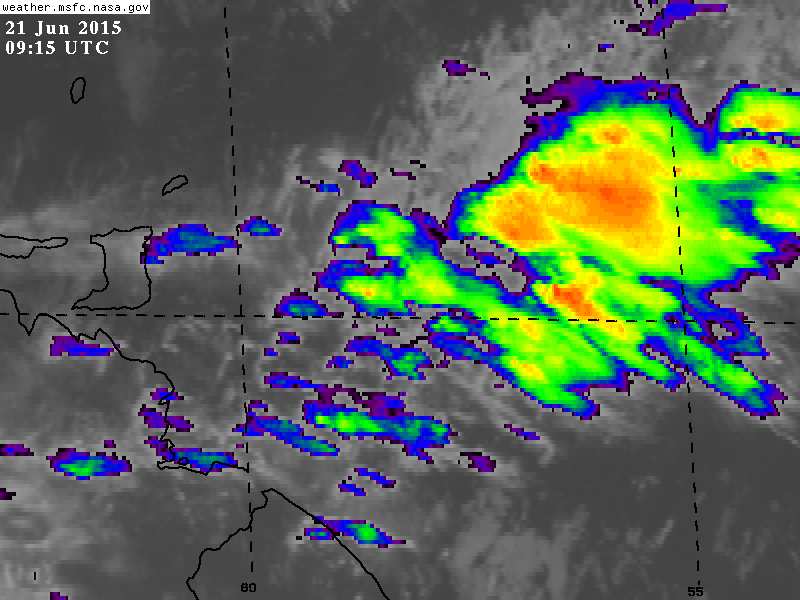
- From: Ian Martin Borde <readkrox51 at gmail.com>
- Date: Sun, 21 Jun 2015 06:21:54 -0400
|
Trinidad & Tobago, W.I.
Sun. 21st. June 2015 06 : 10 a.m. Good Morning everyone, The attached image taken at 05:15 a.m. this morning, along with quite a few others I saw, make this blob, our fifth for the rainy season and second with cyclonic possibility, seem much worse than it really is. In reality, Diego Martin, Trinidad, has 400' -1,000' (Ft.) grey clouds moving at about 35kph. Sparse as rain clouds go. This scientifically means two things. "It's going south america or is too fast to be cyclonic over t'dad." "The lowness of the clouds means showers are here." (In localized areas). Typical for let's say the first 15 blobs. To repeat: the rain has reached but looks worse than it really is. God bless Tomorrow is always a different matter. Attachment:
21st june 515 am.jpg
Description: JPEG image
|
|
- First Flash Flood
|
- From: Stephen Abouhamad <stephen_abouhamad at hotmail.com>
- Date: Tue, 16 Jun 2015 03:50:35 +0000
|
Trinidad and Tobago Good night to all readers of StormCarib. Well today Trinidad had a rude awakening to the rainy season. One of the season's early Tropical Waves made its presence felt as strong showers greeted everyone as they woke up this morning. intense rainfall was felt throughout Trinidad which caused flooding in our Capital. I was also caught by surprise as I was trapped in the middle of one of those rain showers while inside a business place for over a hour waiting for the flood waters to subside. We all should get ready for the season ahead of us. Regards
S Abouhamad
|
|
|
- Fourth Blob maybe nascent Cyclonic - 72 hrs.
|
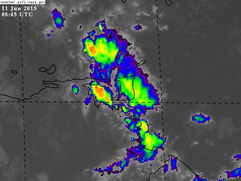
- From: Ian Martin Borde <readkrox51 at gmail.com>
- Date: Sat, 13 Jun 2015 23:20:03 -0400
|
People of Paradise,
One of the attached pics below is testimony of how ' N~o~r~m~a~l ' June 2015 the wettest month in T'dad & T'bgo has been in terms of Atmospheric Conditions. That night it rained. For practically three hours in fore-day morning it rained. Not drizzled, not thunder showers, it rained. (with gentle breezes). The morning sun, dawn, and trek to work was a marvelous, miracle of re-creation, alleviation (from dryness), and an overall Bliss of pressure, temperature and humidity. Please, please, please, let's continue to live of of The Earth. That was the third blob. In 36 hrs. for T'dad and T'bgo, 72 hrs. for The Virgin Islands areas, expect a fourth blob. Except that it's from 39 W. - 47 W. Longitude, (large) and that it is concentrated below 9 N. Latitude in The ITCZ, only early arthritis says it can be nascent cyclonic. There is too much SAL, it's the first one, it is too south, there is too much wind shear. Whatever happens, I am keeping my boots on between June and November and when I lose our umbrella buy a new one. Now, THE MAIN EVENT : T'dad & T'bgo will have National Elections, September 7th. God bless Attachment:
11th june 445am.jpg
Description: JPEG image
Attachment:
13th june 915pm.jpg
Description: JPEG image
|
|
- Rain again, but less, .....
|
- From: Ian Martin Borde <readkrox51 at gmail.com>
- Date: Wed, 3 Jun 2015 19:44:26 -0400
|
In 12 - 36 hrs.
There will be another blob with less intensity and duration than the first for the season. God bless |
|
- Proof - Aloof
|
- From: Ian Martin Borde <readkrox51 at gmail.com>
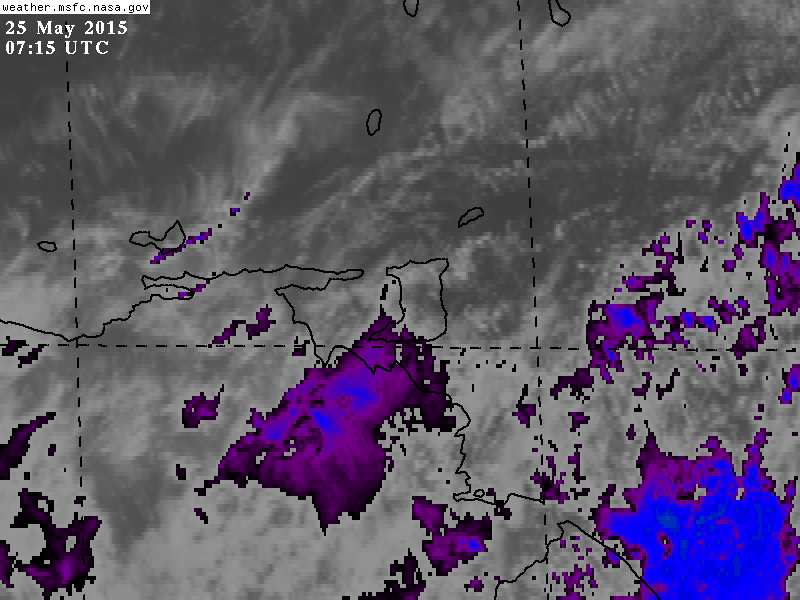
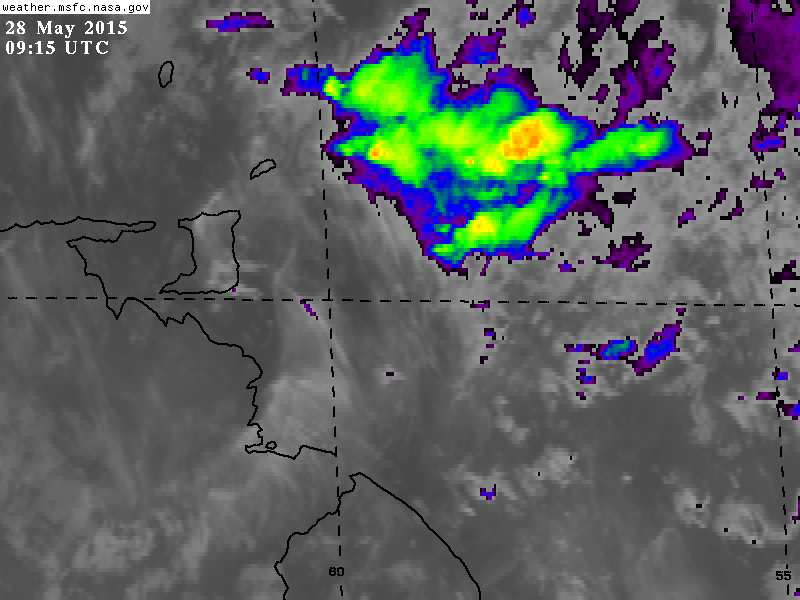
- Date: Thu, 28 May 2015 06:10:56 -0400
|
P/Vly, D'go M'rtn, T&T, W.I.
2015-05-28th. Thu.
6:00 a.m.
Good Morning, People of Paradise, We had a massive shower last night. It was so refreshing to the atmosphere that in fits of waking moments, (audible moments), we slept thru it. The ground is soaked !!! The rheumatoid fever is dissipating. As a pedantic aside; There is more than a hint of moisture in the atmosphere, meaning more is to come, .... ...TROPICAL WAVES...
A TROPICAL WAVE IS W OF THE ITCZ FROM 1N TO 14N WITH AXIS NEAR
54W...MOVING W AT 15-20 KT DURING THE LAST 24 HOURS. SSMI TPW
IMAGERY SHOW THE WAVE CONTINUES EMBEDDED WITHIN ABUNDANT
MOISTURE IN THE MIDDLE TO LOWER LEVELS. SATELLITE DERIVED WINDS
AND MODEL GUIDANCE SHOW A DIFFLUENT ENVIRONMENT ALOFT E OF THE
WAVE AXIS THAT SUPPORT SCATTERED MODERATE CONVECTION FROM 03N TO
07N BETWEEN THE AXIS AND 50W. FURTHER CONVECTION IS BEING
HINDERED MAINLY BY STRONG DEEP LAYER WIND SHEAR IN THIS REGION
OF THE TROPICAL ATLC. Attachment:
25th May 2015 315am.jpg
Description: JPEG image
Attachment:
28th may 515am.jpg
Description: JPEG image
|
|
- skirting danger - 36 hrs. -
|
- From: Ian Martin Borde <readkrox51 at gmail.com>
- Date: Tue, 26 May 2015 05:01:59 -0400
|
Hello,
People of Paradise, There is an imminent blob that will skirt us well within 36hrs. There are two good news and one bad news; - It is moving very fast. - It is very south. The bad news is that, - It will be at its biggest at about 62 W. Longitude. That is also when it will make landfall. (as a tropical wave). Keep your boots on, and God bless |
|
- The season starts today (ample evidence) -
|
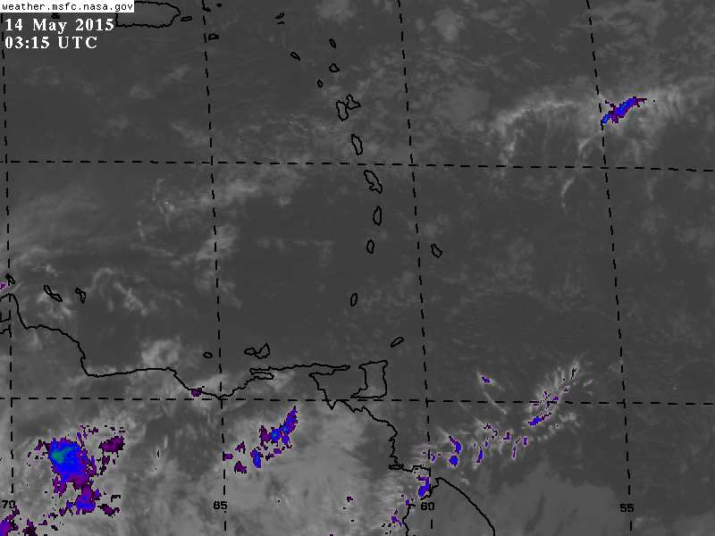
- From: Ian Martin Borde <readkrox51 at gmail.com>
- Date: Thu, 14 May 2015 00:23:57 -0400
|
Good Day, Good Everything People of Paradise,
Today, Thursday 14th. May 2015 has hovering over it ample evidence that the rains are here. For the Caribbean, The Season has Started ! May God Bless Us in Our Endeavors, .... Attachment:
13th may 2015 1115 pm.jpg
Description: JPEG image
Attachment:
India & Nepal's earthquake april 2015.jpg
Description: JPEG image
|
|
- Dual Case Scenario - possible but not probable - 36 hrs.
|
- From: Ian Martin Borde <readkrox51 at gmail.com>
- Date: Sat, 9 May 2015 09:44:05 -0400
|
Good Fellows of Paradise,
I forecast rain, (specially as it just fell). (tee hee) ( like Grenada ) ! AND SOON. TS. Ana is 12 - 36 hrs. from true landfall but my opinion is it will head out to sea. There is a system forming, ( possible after eastern Caribbean ), at 40 W. That 's not where the rain came from. But at 60 W. the bands (I call feeder bands that make it cyclonic) are touching the coast of Trinidad. Definite rainfall, ..., in 12 - 36 hrs., (If like all the previous the whole gamut doesn't go Venezuela or even Brazil.). Thanks and Praise |
|
