![[stormCARIB - Caribbean Hurricane Network]](stormcarib.gif) |
Caribbean Hurricane Network
- Updates from the Islands - |
|
|
| 2024 Atlantic Hurricane Season | | | Alberto | Beryl | Chris | Debby | Ernesto | Francine | Gordon | Helene | Isaac | Joyce | Kirk | Leslie | Milton | Nadine | Oscar | Patty | Rafael | Sara | Tony | Valerie | William | |

|
Active Tropical Systems: None!
Atlantic Hurricane Season is from June 1 - November 30

GOES Satellite - Zoomed in on the Caribbean (07:30 UTC, 19 minutes ago)
Scale bar (lower right) is 250 miles. [more satellite imagery].
See storm-centered satellite image and loop in the tools section below (if available)
Monday, April 8, 2024 10:18AM PDT - Another 'hyper-active' forecast
- Tropical Storm Risk, recently absorbed by EuroTempest, a European storm and weather risk management services to the (re)insurance market, has issued their forecast for the upcoming season. It is exactly the same in number of storms as the one by Klotzbach et al's (see earlier post). They also call for a 'hyper-active' season with 23 tropical storms, 11 hurricanes, and 5 intense hurricanes.
They say: "The reason why the TSR extended forecast for the 2024 Atlantic hurricane activity calls for a hyper-active season is our expectation that the warm sea surface temperature anomalies currently present in the Atlantic Main Development Region (MDR) and Caribbean Sea will persist through August-September 2024, and a moderate strength La Nina event will develop through spring/early summer and persist through summer and autumn.". Indeed, high water temperatures and La Nina conditions means bad news for us. Read the full report here.
Another 'hint' to start preparing now! In reality there is still a relatively small chance that a 'big one' will end up on your doorstep (see the table in my earlier post), so don't get too worked up about these forecasts. But you will feel better if you are well prepared. This might be a good year to invest in those hurricane shutters, if you don't have them already... -Gert
Thursday, April 4, 2024 10:15AM PDT - Extremely Active Hurricane Season forecasted...
- Today Klotzbach and his team at Colorado State University issued there well respected forecast for the upcoming season. And it is not looking good... This may come as no surprise, since last year we had the battle between El Nino, which decreases hurricane activity, and warm sea surface waters, which increases hurricane activity. El Nino lost... This year we won't have an El Nino, but La Nina conditions, which normally enhances hurricane activity, plus the record warm sea surface temperatures are still here!
The forecast calls for 23 (!) named stormes (14.4 is normal), of which 11 are expected to reach hurricane strength (7.2 is normal) and 5 reach major hurricanes status (3.2 is normal). This is the highest number of storms ever forecasted by Colorado State in April...
The major drivers are La Nina and high sea surface temperatures. Although we are still in an El Nino, it is expected to fade in the next few weeks, and transform to La Nina conditions at the peak of hurricane season. During a La Nina vertical wind shear is lower in the Atlantic, making it easier for tropical storms to develop and become stronger. Sea surface temperatures in the tropical Atlantic are currently at record levels, see for example the last plot on the my satellite imagery page (yellow/orange means above normal, it looks like 1-2° Celcius or more above normal!). And it is expected to stay above normal, giving more fuel to hurricanes...
Normally the April forecast doesn't have much skill, but this year they are more confident that there will indeed be an active season. It is hard to argue otherwise, with record sea surface temperatures and an La Nino, two of the main drivers in hurricane activity...
What does it mean for the Caribbean... For the Caribbean region the probability of at least one major hurricane tracking through the region (a big area) is 66% (normal is 47%, last year it was 49%). In the table below I summarized the chance of a major hurricane moving within 50 miles of a specific Caribbean island/country compared to the long term average (1880-2020) (source: https://tropical.colostate.edu/TC_impact.html). Note that some of the numbers are biased by area, for example The Bahamas. In any case, just one big storm in your backyard is more than enough. It seems that this is the season that you invest in some good hurricane protection.... Preparation will be key this season.
A good writeup can also be found on Jeff Masters' Eye on the Storm blog at Yale Climate Connections. It does not really make you happy reading it... -Gert
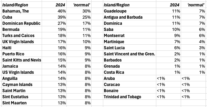 | | Probability of a major hurricane traveling within 50 miles |
... Older discussions >>
|
| Current Tropical Weather Outlook (NHC/TPC): |
|
|
NWS National Hurricane Center Miami FL
410 PM EDT Wed Apr 24 2024

For the North Atlantic...Caribbean Sea and the Gulf of Mexico:

East-Central Subtropical Atlantic:
An area of low pressure located about 900 miles northwest of the
Cabo Verde Islands has been producing a small but persistent area
of showers and thunderstorms to the east of its center since this
morning.  However, the low is forecast to move southwestward at 10
to 15 mph into an area of stronger upper-level winds tonight and
tomorrow, and additional development is not expected.

No additional Special Tropical Weather Outlooks are scheduled for
this system unless conditions warrant.  Regularly scheduled
Tropical Weather Outlooks will resume on May 15, 2024, and Special
Tropical Weather Outlooks will be issued as necessary during the
remainder of the off-season.
* Formation chance through 48 hours...low...10 percent.
* Formation chance through 7 days...low...10 percent.

$$
Forecaster Berg/Brown
|
| More detail in the Tropical Weather Discussion or view the Graphicast Image |
|
|
stormCARIB is brought to you by GoBeach Vacations
- Your Accommodation Specialist for the Caribbean - |
|

stormCARIB is hosted
at and supported by
pairNetworks
|
|
|
Support stormCARIB
-- Donations needed --

Latest local updates from the special
hurricane correspondents on the islands:
- St.Thomas [Apr 23 18:50]
- Barbados [Apr 20 20:11]
- Nevis [Apr 20 18:15]
- Aruba [Apr 19 11:25]
- Trinidad & Tobago [Apr 17 20:48]
- Anguilla [Mar 15 15:38]
- Tortola & Virgin Gorda [Mar 5 9:55]
- Bonaire [Feb 28 13:01]
- St.Maarten/St.Martin [Feb 8 12:29]
- Saba [Feb 6 15:10]
- St.Croix [Nov 30 23:03]
- Dominican Republic [Nov 19 22:59]
- Jamaica [Nov 16 23:29]
- Dominica [Nov 4 5:28]
- Antigua [Nov 2 14:31]
- Curaçao [Oct 31 4:42]
- Guadeloupe [Oct 22 6:24]
- Montserrat [Oct 21 19:51]
- General Update [Oct 21 18:40]
- St.Kitts [Oct 21 16:02]
- [Oct 21 15:03]
- St.Lucia [Oct 20 13:11]
- Puerto Rico [Sep 27 16:44]
- Turks & Caicos [Sep 12 21:28]
- Martinique [Jun 23 8:17]
Only reports received for this season are listed. See the archive for previous years.
Links to excellent websites:
- Navy/NRL Monterey
- NOAA/NESDIS (floater loops)
- RAMSDIS Imagery
- Radar Composite - E-Carib.
- Caribbean/Atl. buoy data
- RT model guidance (RAL/NCAR)
- STORM2K forum
- Tracking Waves (McNoldy)
- Tang/UAlbany (model tracks)
- tropicaltidbits.com
- weathernerds.org (ensembles)
- CIMSS/U.Wisc-Mad
- Brammer/UAlbany
- ECMWF Model Forecast
- Jeff Masters Blog
- Brian McNoldy Blog
- Michael Lowry's Blog
- zoom.earth hurricane tracker
- more...
Storm definitions by wind speed:
- Tropical Depression <39mph
- Tropical Storm 39-73mph
- Cat.1 Hurricane 74-95mph
- Cat.2 Hurricane 96-110mph
- Cat.3 Hurricane 111-129mph
- Cat.4 Hurricane 130-156mph
- Cat.5 Hurricane >=157mph
More info in the Practical Guide
Wind force relative to Category 1:
- Tropical Storm 39mph: 0.28x
- Cat.1 Hurricane 74mph: 1x
- Cat.2 Hurricane 96mph: 1.7x
- Cat.3 Hurricane 111mph: 2.3x
- Cat.4 Hurricane 130mph: 3.1x
- Cat.5 Hurricane 157mph: 4.5x
- Irma 185mph: 6.3x
|
| - - - Local hurricane correspondents wanted! - - - |
The local hurricane correspondents are the heart and soul of stormCARIB. They are the people who live on the island and write to us what is going on around them. First hand very local personal reports instead of very limited or sensationalized coverage by the general media. Do you live on one of the islands? We need your help! We are looking for more people who are interested in sending us a few paragraphs about the situation on your island before, during and after a storm hits. You don't need to be a weatherman or expert on the subject, just share with us what you know, feel and see on your island. Your help will be really appreciated by Caribbean people living abroad with family living on the islands, future visitors who have their Caribbean dream-vacation booked, etc.etc. Reliable, not-sensationalized information is just so hard to get in crisis situations. Help keep the rest of the world up-to-date with what is really happening! We really need you, Georges back in 1998, and many others since then are proof! If interested, contact gert@gobeach.com.
WHAT TO FIND ON StormCARIB.com:
This website is all about the Caribbean. Here you can find information, weather discussions and local reports regarding tropical systems threatening the Caribbean islands. A central part of this website is the volunteer network of special local hurricane correspondents, living on the islands, who will report, when need be, on how it looks and feels like around them. Above also hopefully easy to understand weather discussions by me and Dave. In addition, as an aid in locating family or friends on the islands in an emergency situation you can post your 'plea for help' on the bulletin board. Also featured on this website is the Quick Hurricane Web Resource Navigator, for easy locating to the least overloaded webserver for National Hurricane Center advisories and the latest satellite images. Another part of the Caribbean Hurricane Network is the 'practical guide' to hurricane tracking with unit conversions, definitions, tips, links, etc. You can also find out how close the storm is and how many hours you have left to prepare plus you can map the closest point of approach of a hurricane to your location. New is the climatology of Caribbean hurricanes section. Find out when the real peak of hurricane season is for individual islands, view hurricane tracks passing by the islands over the last 150+ years. An archive with detailed reports of how the Caribbean islands fared during the 2007, 2006, 2005, 2004 (incl. Frances and Ivan), 2003, 2002, 2001, 2000, 1999 (incl. Floyd and Lenny), 1998 (incl. Georges and Mitch), 1997 and 1996 seasons are still available as well. Plus there is more, like storm-centered satellite images, make your own local satellite loop, etc. Hope you find the information on this website (now counting over thousands pages with original content) helpful. Comments always welcome!  RSS web feed available. As a side note I am now accepting donations as well. Thanks for visiting!
Maintained & moderated by: Gert van Dijken (gert@gobeach.com).
Weather discussions also by Dave McDermott, St.Thomas, USVI.
Disclaimer
The information on these pages is derived from weather statements provided by the National Weather Service, the National Hurricane Center, and others, and from hurricane correspondents in the Caribbean. I tried to translate the official weather statements in more layman's terms. Also, I tried to fill the gap in reporting on what is happening in the Caribbean, instead of the US (there are already many other good website which focus on the US). Keep in mind that my statements are my own interpretations from the information available to me. Therefore, use the information at your own risk, and above all, don't use these webpages for making life-or-death decisions, always rely on the official and qualified authorities! Accuracy of eye-witness reports by the special hurricane correspondents have not been checked. They may be highly subjective. The author can not be held responsible for lost property, ruined vacations and the like. Despite all this I hope you found the webpage informative and useful. These pages do not have a commercial intent. GoBeach Vacations provided the means and opportunity to start all this. 'Unfortunately' this website has become too popular, placing too much load on the gobeach.com webservers. Luckily, starting in 2000, my excellent webhost provider, pairNetworks, liked my website so much that they support services whenever they can. Comments are always welcome. Just send a note to gert@gobeach.com. Gert
)