
|
|
Caribbean Hurricane Network- Updates from the Islands - |
|
|
The 2006 season was luckily very quiet for all of us. The only thing to note is that there was one more storm then we thought. There were actually 10 storms, not 9. Not many people have noticed since this storm was so far north and didn't touch land as a storm. Exceptional this year as well is that Portugal was almost hit by a hurricane. Also, the Pacific side of Mexico, esp. the Baja California region had numerous (almost) hits of big ones. Below is a recap of the storms, shown are date (when the storm was strongest), winds (mpg), category (ts=tropical storm, h1=cat-1 hurricane, ...) and name. See also the NOAA 2006 Track Map below.
      date        wind  cat  name
     12 Jun 2006    69   ts  ALBERTO
     17 Jul 2006    52   ts  NOTNAMED
     19 Jul 2006    58   ts  BERYL
      2 Aug 2006    63   ts  CHRIS
     23 Aug 2006    52   ts  DEBBY
     27 Aug 2006    75   h1  ERNESTO
     10 Sep 2006    92   h1  FLORENCE
     14 Sep 2006   121   h3  GORDON
     18 Sep 2006   121   h3  HELENE
      1 Oct 2006    86   h1  ISAAC
The heart of the Caribbean Hurricane Network are the personal reports send in by the special hurricane correspondents on the islands. Find out what happened on your favority island during the 2006 Hurricane Season by following the links below.
|
- Tortola [May 6 10:34] - Culebra (PR) [May 6 7:09] - Dominica [May 5 9:34] - Bonaire [May 4 19:37] - Antigua [May 4 16:27] - Dominican Republic [May 4 11:00] - Grenada [May 3 16:00] - Cayman Islands [May 3 14:23] - Turks & Caicos [May 3 13:42] - Saba [May 1 7:28] - Nevis [Apr 27 7:10] - Jamaica [Apr 26 5:54] - St.Thomas [Apr 23 17:22] - Guadeloupe [Apr 23 14:45] - Puerto Rico [Apr 22 21:45] - Jost van Dyke [Apr 22 21:38] - Vieques (PR) [Apr 22 7:14] - St.Croix [Apr 17 7:47] - St.Maarten/St.Martin [Apr 14 11:44] |
- St.Lucia [Apr 1 22:50] - Barbados [Mar 30 14:09] - Trinidad & Tobago [Mar 25 13:36] - Anguilla [Feb 27 9:50] - Bermuda [Jan 26 14:25] - Montserrat [Jan 8 6:04] - Statia [Dec 22 9:18] - Aruba [Nov 21 8:14] - Honduras [Nov 19 13:59] - Martinique [Oct 24 11:44] - Curaçao [Oct 24 7:04] - St.Kitts [Oct 19 10:32] - St.John [Oct 18 19:52] - Haiti [Sep 3 13:17] - Belize [Sep 2 16:58] - Bahamas [Aug 30 1:00] - Guatemala [Aug 28 16:37] - St.Vincent & Grenadines [Aug 25 8:54] |
Following is an archive of all weather discussions Dave and I posted. They are in reverse chronological order, with the most recent storm discussion on top. Use the index of storm names above to find your 'favorite' storm. If you want more background information on specific storms, I have found the 2006 Atlantic Hurricane Season section in the Wikipedia a great resource. Also, visit the Hurricane Research Division of NOAA's Atlantic Oceanographic and Meteorological Lab for 'best track' data of all 2006 storms (incl. the not named one). The track map below is from that website as well.
- - 2006 Hurricane Tracks - -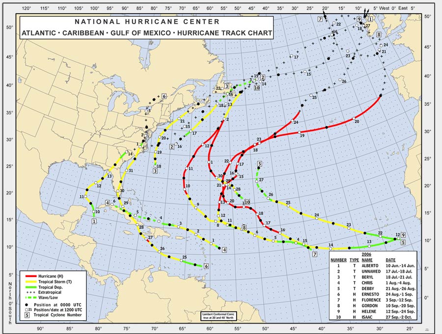
- - Source: NOAA/AOML Hurricane Research Division - -
| - - - 2 0 0 6 Atlantic Hurricane Season - - - |
Note that reports are in reverse chronological order. It's easiest to start at the bottom and scroll upwards.
Thu, 26 Apr 2007 14:10:12 -0400 (AST) - Soggy!
Good afternoon!

The, at times, torrential rain this morning has finally abated but more is
on the way according to long range radar. Jouvert' has finally finished
but the party still continues on the waterfront making cross-island
traffic very rough.

No Culebra, it is not snowing in St. Thomas! It is true the Weather
Channel and the WeatherUnderground have been showing, for the last 2 days,
out low temperatures in the 20's and 30's! The Weather Channel, yesterday
morning at 5:00 am, said we set a new record low of 30 beating the old
record set in 1968 of 68 degrees! This morning at 4:15 am, a new record
low was set as well below freezing! Isn't there any oversight here by
humans? It's funny, in a stupid sort of way, to see a map of the entire
northeast islands with Anguilla at 78, San Juan at 76, St. Croix at 76 and
St. Thomas at 21! But letting it go to long is really unacceptable and you
would think with two highly regarded different organizations, one would
certainly catch it.

The sun is really trying to come out now. Muggy will be the word for the
rest of the day! Have a great one!

Dave
Wed, 25 Apr 2007 06:45:41 -0400 (AST) - Sunshine!
Good morning!

Taking the bad with the good. Along with some very welcomed rain came the
return of a very unwelcome pest: the Mosquito! having not been bitten in
my house since last November, I was feeling pretty bitten-proof for quite
a while but alas, that came to an end last night. 6 bites! Enough to keep
a deep sleep from happening, that's for sure. the great mosquito hunt will
be on tonight!

Since we have had so much rain, plenty of standing water will be around so
please empty it wherever it collects if you can. That water is ripe
breeding grounds for these little buggers who sometimes carry dengue
fever, a form of malaria you do not want to have and some strains can even
be fatal.

And now, for the rest of the story..... My power was finally restored at
12:05 pm from 2:30 am. It came on just as I finished cleaning up the
floors, wet towels, and rugs. Fortunately, it wasn't as bad as I
envisioned and a good training exercise for the upcoming hurricane season.

Dave
Tue, 24 Apr 2007 06:32:20 -0400 (AST) - Still raining!
Good morning again!

It's 2 hours later and it is still raining! We have picked up almost 1 1/2
inches in the last hour alone according to Doppler Radar estimates and
it's raining the proverbial cat's and dog's right now.

Called my house a few minutes ago. Power is still off as my answering
machine isn't picking up. A look at the Doppler also shows more rain on
the way for another hour at least. Flooding will be problem as drainage is
poor. I'm going to go home around 8:30 and see if where I live is floating
down the mountain to the sea. I'm sure I'll have plenty of water on my
floors at the very least. 50%? Augh!

Dave
Tue, 24 Apr 2007 04:32:38 -0400 (AST) - Catch 22
Good morning!

It's usually hard to find any humor when you are at work at 3:45 am! No, I
am not here because I really want to be. The power (Oh how I sympathize
with Miss Mermaid), is out again for the third time in the last 24 hours
in my area on top of Red Hook on the Eastern end of St. Thomas. Ya think
maybe WAPA could fix it right, at least the second time? Oh well, heat,
humidity, and the prospects of no power untill after their warehouse opens
for parts at 7:30 am gave me no alternative but to head for somewhere dry
and lit. Yes, I have a generator but at 3:30 am? I like the few neighbors
I do have and I still wouldn't go back to sleep!

About that lack of humor. Having just read the latest forecast and taken a
look at the local radars, the official forecast of a rain chance at 50%
appears to be off by 50%! The radar, if current patterns stay the course,
put rain, heavy at times, pouring for the next, at least 2-3 hours. A
certain correspondent a few days ago who pined for rain (LOL...)definitely
got more than she bargained for as well as most of the rest of us. It
appears only the water truck haulers will be able to take Carnival Week
off. Virtually all of the northern islands have received over 3-6 inches
with isolated areas picking up over a foot! On a landscape which almost
had a farscape look a few days ago, green and plenty of it, is now busting
out everywhere. Drought? What drought?

The Catch 22 side is flooding, road-ponding, rocks off hillsides onto
roads as well as mudslides, contaminants being washed into the oceans and
onto our delicate reefs contributed by contractors, developers and
homeowners who do not use mitigation factors to stop run-off, a soggy
start to the last and busiest week of Carnival, and the realization that
hurricane season is just around the corner? Ah, now I remember what it's
like to take a bird-bath in the dark!

Be safe!

Dave
Friday April 13, 2007 - Climatology Updated
I have just updated the climatology section to include the 2006 season, covering all the way back to the year 1851. It now consists of over 650 webpages and over 4500 images! The last season was luckily very quiet for all of us. The only thing to note is that there was one more storm then we thought. There were actually 10 storms, not 9. Not many people have noticed since this storm was so far north (37->60N) and went eastward (68W->46W). Below is a recap of the storms, shown are date (when the storm was strongest), winds (mpg), category (ts=tropical storm, h1=cat-1 hurricane, ...) and name. Hopefully the 2007 season will be as uneventful! -Gert
      date        wind  cat  name
     12 Jun 2006    69   ts  ALBERTO
     17 Jul 2006    52   ts  NOTNAMED
     19 Jul 2006    58   ts  BERYL
      2 Aug 2006    63   ts  CHRIS
     23 Aug 2006    52   ts  DEBBY
     27 Aug 2006    75   h1  ERNESTO
     10 Sep 2006    92   h1  FLORENCE
     14 Sep 2006   121   h3  GORDON
     18 Sep 2006   121   h3  HELENE
      1 Oct 2006    86   h1  ISAAC
Wed, 11 Apr 2007 06:24:30 -0400 (AST) - Dry, Dry, Dry
Good morning!

The way the local Doppler radar has looked the last few dyas, one would
think Puerto Rico has been slammed with storms and the Virigin Islands has
been pretty wet as well. The real reason? Ground clutter! Remove that and
a clean, crisp picture shows up with only very widely spread light showers
dotting the seas. Some radar sites allow you to remove the clutter or show
it. Why bother to show it? I honestly don't know why. But, if shown, it
doesn't give a true picture to most viewers.

76 degrees under mostly clear skies with light east winds out of the east
at 8 mph and seas around 3-4 feet. A pretty good morning most of us would
agree although we need some more steady rain badly. I do not know at the
moment what our rainfall deficit is since October but I have seen it
drier. Don't worry, Carnival is starting to 'Jump Up" and that's where
will start to see more shower activity.

Ocean temps are already at 82 degrees here around the Virgin Islands.
While great for visitors and those who work in the water, the early warmth
does not bode well for the future hurricane season.

Dave
Wed, 4 Apr 2007 06:28:42 -0400 (AST) - Rain and WAPA
Good early morning!

As they say, with the good comes the bad. I'm not too keen on that saying
but it appears to ring perfectly true when this one event happens: The
power in my area always (well, 85% of the time) goes out when it rains.
The rain is very good as it is badly needed to end our seasonal dry spell
and fill those cisterns with $$$ saving water. But if the power goes off
almost every time, (last week it was from 2:00am until 10:30 am), the $$$
savings could evaporate very quickly when the power comes back on and your
refrigerator takes an electrical surge and goes poof along with those
expensive groceries. Now, I do have surge and UPS's on almost everything
but they usually don't last 8 hours!

Ok, enough of that. Now to live action! The talk of the Caribbean and
certain areas of the mainland is the early season prediction by Dr. Gray
and his team: 17 named storms and 5 major hurricanes! El Nino is going to
be a non-issue so there is no help there. Saharan dust will be if it keeps
coming around after August like it did last year while the ocean is pretty
warm already and that is not good. Erring on the side of caution as I
usually do (you learn that after taking a direct hit from one of these
monsters!), I agree the season will be active. Remember, it's not the
number of storms that cause the concern. It's that one that we all think
is not going to come close that winds up being the bad one.

Currently, yes, it's still raining lightly, the winds are pretty quiet out
of the northeast and it's cool for the islands at about 72 but it 67 up
the mountain last night. Ahhh, good sleeping weather!

Dave
Tuesday April 3, 2007 - Busy season forecasted
Klotzbach and Gray of Colorado State issued their second forecast of hurricane activity for this season. They do expect a busy season, with 'net tropical cyclone activity' 85% higher then normal. Analog years with similar oceanic and atmospheric conditions around this time are among others 2003 (actually relative quiet for the Caribbean, big ones were Fabian, Isabel) and 1995 (much worse for the Caribbean, big ones: Luis and Marilyn).
Last year's weak El Niño is gone, and we might be in for the opposite phase, La Niña, which enhances Atlantic hurricane activity. This together with the higher then normal sea surface temperatures in the Atlantic is reason for the high estimate. In summary, the forecast is for 17 named storms (9.6 is normal), 9 hurricanes (5.9 is normal) of which 5 will be Category 3 and up (2.3 is normal). The full report can be found on the Colorado State website. -Gert
Wed, 28 Mar 2007 04:15:43 -0400 (AST) - Finally!
Good early morning!

Busy cruise ship season so far (why do you think I am at work at this
abnormal hour of the morning?)with the end just 5 weeks away. A break is
nbeeded to catch up and then, it's that "other season" lurking just ahead.
That's right, June 1st is just around that spring corner and it's never
too early to think and plan!

The weather radar can be misleading sometimes and just plain not work
others. It seems to not work (our San Juan Doppler) usually when a system
is near enough to cause people to check it. "Down for maintenance" is a
regularly seen phrase. Now, not knowing the real reason it is down more
than it should be wouldn't be much of a problem for most but alot of
people depend on that radar for their daily lives.

Misleading I mentioned with special regards to yesterday's working radar.
Plenty of rainshowers of the light to medium variety were shown over the
Virgin Islands but alas, we didn't receive as much as the radar would
indicate. Alot of those light ones never actually made it to the ground
but will still show up on the Doppler. St. Croix seemed to get a good
healthy dose and some areas of the island did, but not all as was
indicated.

Nevertheless, what we did receive was a blessing and should be appreciated
as such. While not enough to break the Lenten dry cycle, it did give hope
to all of us whose cisterns and pipes have been squeaking as our supplies
slowly dwindle waiting for more. The best part was these rains were not of
the heavy, run-off before it sinks in variety, which would cause plenty of
run-off in our ocean surroundings and lots of soil and rocks in the
roadways.

Time to hit the books! Be safe!

Dave
Mon, 19 Mar 2007 07:07:07 -0400 (AST) - Dry continues with haze
Good Monday morning!

Another work week officially begins but as we here in the Caribbean know,
all weeks between Oct. 15th and April 30th tend to run together with no
clear definition of a day off or a weekend for that matter due to high
tourist season. I've had three half days off in the last two months!

Weather-wise, it has been very dry. Not only are the northern islands
brown but the ever icreasing amount of water trucks lumbering up and down
the mountains is straining an already overcrowded road system. The middle
islands like Dominica and St. Kitts have received better amounts of rain
and hence look green like we all see in the postcards. It is still the
Lenten time and we are in a historically seasonal dry time so this really
is nothing new.

What is new is the amount of African dust in the air. This very early
season dry, red-particled airmass arrived a few days ago from it's long
journey across the Atlantic and it has combined with volcanic ash from
Montserrat brought up by southeasterly winds to play havoc with visibility
on land, sea, and even for air travel.

Fortunately, this should start to abate late this afternoon. The large
cold front now off the eastern tip of Hispaniola should elongate or
flatten out just to the north of Puerto Rico and the Virgin Islands but
getting close enough for some scattered badly needed showers tonight and
Tuesday. After that, it's looking dry again until Monday.

Back to work now. Have a fun and safe week!

Dave
Sun, 11 Mar 2007 16:40:02 -0400 (AST) - Thank you and Dry!
Good Sunday afternoon!

Today is the eve of the 1st anniversary(?) of my wife Barbara's untimely
passing. I say untimely because I'm selfish for obvious reasons. But, I
know in my heart she is in a higher and better place. That doesn't make it
any easier then or now but I would like to take this opportunity before I
say something about the weather to say:

THANK YOU!

To all of our family, both US and UK based, our friends both in the Virgin
Islands and elesewhere around the globe, our co-workers, and to you in
StormCarib.com land who sent many, many messages of sympathy and support.
Without all of your support, I'm not sure I would be sending this message
right now. I thank all of you from the bottom of my heart!

Weather-wise, it is DRY! Traditionally, this is a very dry time: from Lent
until about a week before Easter. The Virgin Islands are a dirty color
brown with a few green patches righ now with no real rains in sight for at
least a week but we could get lucky next week.

Saharan dust and Volcanic ash have combined for some very hazy days and
for those who like to dust (who's that?), it's your paradise! For the rest
of us, it's a minor irritant except for the oldest and youngest of our
population with respiratory issues: not a good thing for them.

Water temps are around 80-81 and air is 84 degrees with a sun factor
around 11! Humidity is low due to the dust/ash combo. We need some soaking
slow rain!

Dave
Thursday March 8, 2007, 22:20 PST - La Nina
According to NOAA, we might have a La Nina coming in the next two to three months. Unlike an El Nino, this enhances hurricane activity... Hopefully it peters out just as fast as the last little El Nino... Press release at Reuters.com. -Gert
Mon, 19 Feb 2007 18:10:25 -0400 (AST) - Showers!
Good afternoon!

One of these holiday weekends, I'm not going to have to work all of it and
enjoy some of that beautiful sunshine we've been having. So now, I am
taking tomorrow off from work as family is coming in on the cruise ship.
The weather tomorrow? Showers of course!! Oh well, we really do need the
rain as the island is pretty parched as in brown hillsides, not those lush
green ones you see on your postcards!

When we do get weather from the West, it's usually blustery and stormy but
this system doesn't seem to have much punch except for rising and confused
seas (high surf advisory is up making a few of my younger friends very
happy!)and a high wind advisory is possible late for higher elevations.
There goes my deck furniture down the hill again. Still beats 2 feet of
snow though (or more!).

Looking far ahead, well, not that far, were are all hoping El Nino sticks
around for the summer. This will help immensely to keep a possibly active
season from happening. It's never too early to think about these things!

Time to leave work and enjoy a cold one. Have a pleasant and safe evening!

Dave
Mon, 12 Feb 2007 13:31:42 -0400 (AST) - Sunny and Cold!
Good afternoon!

The sun set last night with a brilliant fiery redness as in the "Red
Rubber Ball" song while this morning's sunrise was just as "Orangely
spectacular" with even the seas in Pillbury Sound rarely seen flat.

So far today, there have been hints of cloud whisps and a plethora of
sunshine with light northeast breezes. Perfect beach and water sports
weather for all right? Yes, I agree except for two things: Today is MONDAY
and I have a COLD! Work told me to stay home today so as not to infect the
rest. So, what do I do? Do I uphold Caribbean tradition and soak myself in
the ocean's salt water known for it's healing properties or just stay in
the house like most people with a cold? You know what ramifications I am
talking about here! The allure is amazing!

The islands are starting to turn brown and water trucks are again seen in
copious numbers; much to the chagrin of anyone stuck behind them going up
a hill. Showers are forecast for Wednesday but nothing of the steady or
organized variety as this is a seasonal dry time of year. However, it
beats by far, upstate NY!

Happy Valentine's Day!
Dave
Wed, 7 Feb 2007 06:57:51 -0400 (AST) - Cold? Not here!
Good o-dark fifty!

As the light begins to awaken the eastern Caribbean and I am wondering why
I am typing this at this time (No, it work-related, not another edition of
Insomniac Theatre!, I am comforted by one thing: It's 5 degrees(F) in my
home town and it's 75 degrees here!

Conditions during a normal person's daylight schedule this week will show
limited shower activity meaning plenty of sunshine. The islands could use
some showers though as they are the brownest I've seen in many months
which is reinforced by the increased number of water trucks lumbering up
and over our hills.

Be warm if you are in the frozen brain zones of the north and stay cool if
you are in the soggy brain zones of the south!

Dave
Fri, 26 Jan 2007 08:52:04 -0400 (AST) - Brrr!
Good morning!

The sun rose into the East Caribbean sky this morning; a bright, red
rubber ball in it's fiery splendor throwing an orange sheen across the
waters. One of nature's most beautiful sights. Then, as I admired the
start of another day, I thought to check on my hometown's weather in way
upstate New York as I had been following the progression of very cold air
into the area meaning winter's dormant status has come to an abrupt end in
the Northeast.

The morning temperature here was 73 degrees in St. Thomas. The temperature
in Elmira is a snuggly 1 degree above 0! Add wind chill and it feels like
18 degrees BELOW 0! Now I know one of the major resons why I live here in
the Caribbean!

Dry conditions exist across much of the northeastern Caribbean and that is
sexpected until mid next week. Humidity is low, sweat levels are low, and
the sunshine levels are high. Ocean temps are around 79-80 degrees which
is cold for some residents: they get spoiled on the 88 degrees water temps
in summer and think now is cold! I find it very refreshing.

To keep your Hurricane/Typhoon/Cyclone interest up in the dead of winter
in the northern hemisphere, we have Tropical Cyclone Arthur in the
southern reaches.

Dave
Sun, 21 Jan 2007 12:30:21 -0400 (AST) - Super Nice!
Good afternoon!

While I'm taking a quick break from the ever present work (it's the cruise
ship season), I thought I would drop a quick note.

The radar out of Puerto Rico is having it's almost weekly, on the weekend,
issues but the larger Caribbean radar shows not much at all in the way of
anything organized precipitation-wise. A few clouds patches pass over from
time to time, courtesy of east-northeast breezy winds with maybe a drop or
two but for the most part, it's brilliant sailing weather toady with
plenty of sunshine. And I do so enjoy the "coolish" nights we have been
having! They are making a good sleep very comfortable. The other comfort
is, since we have only had just less than an inch of rain so far this
month, the mosquito population has appeared to decrease dramatically!

El Nino has definitely left a mark around the world with those vicious
storms in Europe, not to mention our own ice storms across the country. We
here in the Caribbean expect scattered power outages from time to time
(yes, they do happen on drop-dead-gorgeous sunny days also) but at least
it's warm. when itgoes off during or after an ice storm, the consequences
are potentially life-threatening.

OK, time to go back to work. Have a great rest of the weekend and remember
to have fun!

Dave
Mon, 25 Dec 2006 10:52:09 -0400 - Happy Holidays!
Sun, 10 Dec 2006 08:42:56 -0400 (AST) - Cooler and drier!
Good morning!

The crack of dawn hadn't arrived yet so I scanned the southeastern horizon
looking for those 3 elusive planets said to be close together and there
they were! The next time they will be that close will be another 47 years!

Yes, this is the Christmas season and we here in the Caribbean have alot
to be thankful for. It is also the time to reflect on the state of other
areas not so fortunate. We were blessed this year with no storms of worthy
mentioning and that's excellent as always. Our Pacific Island nation
friend has been savaged once again, this time by Typhoon Utor. This is the
6th typhoon to hit the Phillippines this year alone!

Even though most of us here in the Caribbean has experienced at least one
tropical system, none of us has endured 6 direct hits! The chances here
for this to happen are small (no, I do not know the exact percentage) but
still, when it happens somewhere else, it makes you wonder.

Our prayers and thoughts are with all those who have suffered these
terrible storms.

Dave
Saturday, 9 December 2006, 3:20PM EST - 2007 Season...
The hurricane forecasters at Colorado State University have issued there first predictions for the 2007 season. Due to an unexpected El Nino they overestimated the activity of the 2006 season by a lot, which we didn't mind of course. Dr. Gray and his team had forecasted 17 storms, of which 9 hurricanes and 5 big ones. We only had 9 storms, of which 5 hurricanes and 2 big ones. Unfortunately it doesn't look like that El Nino will stay around through the next hurricane season, so we are back to an above normal season...
The tally for the 2007 season: 14 named storms (9.6 is average), of which 7 will reach hurricane strength (5.9 is normal) and 3 big ones (average 2.3). They also predict an above average landfall risk of major hurricanes for the Caribbean... But it's still early, we'll see. We have to be prepared in any case, one bad storms spoils a whole season. Link to Reuters News article and the full forecast. -Gert
Sunday, 3 December 2006, 1:40PM EST - Philippines...
Our hurricane season is over for this year. Nice to have an un-eventful one! In other parts of the world the season was quite the opposite. For example the west coast of Mexico, and esp. the Baja California region seemed to be a magnet for storms. Even worse, the Philippines got hit by four big ones this year! Durian, a category-4 storm just hit the Philippines. Due to massive mudslides over 1000 people could have died... More news on this search Google News. We have been quite fortunate this year... -Gert.
Sun, 19 Nov 2006 10:35:25 -0400 (AST) - Curfew!
Good morning!

Reading St. Croix's account of Lenny reminded me that CURFEW was in effect
here on St. Thomas until noon the 18th which just happens to be my
birthday. Not a good b-day present indeed nor was the fact there was a
late season hurricane, going the "wrong-way" threatening to mash up our
islands right before Thanksgiving.

Currently, it's much better this year. We all have a lot to be thankful
for and El Nino could be a next summer Christmas present as well but
obviously, time will tell that one.

Around us now hazy sunshine, a light breeze, and the potential for some
afternoon light showers but nothing yet. Truly, the islands and their
beauty are something to really appreciate and be blessed with.

Dave
Tuesday, November 14, 2006, 9:22PM EST - Lenny
Around this time, seven years ago we had a big one, Lenny. Kind of hard to imagine that late in the season. Even stranger is that it came from the west, instead of from the tropical Atlantic, hence its nickname 'Lefty Lenny'. Isabel from St.Croix just posted her experiences during Lenny on the St.Croix Reports webpage. More 'live' reports can be found in the archive. Pretty scare... This season was great! A very welcome change! -Gert
Thu, 26 Oct 2006 09:24:10 -0400 (AST) - Halloween
Good morning!

Anyway you look at it, it appears that our local Virgin Islands weather is
doing the "Time Warp" or has been watching coutless re-runs of "Groundhog
Day". Why would I say that you ask? Because, that wimpy wave which had the
audacity to blow-up a few days ago seems to have stalled in the same place
for the last 48 hours off to our east. The axis of the wave actually made
it through the islands but the accompanying convection remains well east.

Helping this wave sit and do nothing is what once was a pretty strong cold
front now almost stalled out to the north. Too bad it probably won't blow
through the Northern Islands as there is crispier, cooler and drier air
behind it. Rats!

Have a safe and Happy Halloween!

Dave
Tue, 24 Oct 2006 09:11:57 -0400 (AST) - Wet Again!
Good morning!

These last few days of drying out from that pesky trough last week are
about to come to an end. Off to our east, a formally weak and virtually
non-existent tropical wave has blossomed into a potential downpour
starting in the lower eastern islands like Barbados, St. Lucia, Dominica
and St. Kitts within the next 48 hours. Not good for St. Croix especially
as they are still cleaning up from the floods of last week.

Rest of tropics except the East Pac are quiet as they should be. With 5
weeks left in the official hurricane season complacency has certainly
set-in. Let's hope we don't need to be re-awakened!

Dave
Sat, 21 Oct 2006 07:50:48 -0400 (AST) - Careful!
Good Saturday morning!

Today dawned sunny with a very weak (SSE 7)wind flow but at least the rain
has stopped temporarily. Doesn't look like it will last for long though as
another moisture surge is traveling from South America northwards on a
beeline for the northern Leeward Islands. Should be here by late
afternoon.

Be careful what we wish for! Before the rains came a few days ago, the
question I was asked on the street was "When are we going to get some
rain? My cistern is low and I don't want to spend $ 300 for a 5,200 gallon
fill-up!" Now, the question is "When is it going to stop?"

St. Thomas and St. John are relatively dry compared to a virtual state of
emergency in St. Croix, only 40 miles to our south and east. It's amazing
what that small amount of distance means when severe weather arrives. Many
roads and low-lying areas are flooded with some roads impassable and even
washed out. Motorists who don't use common sense have had to be rescued
after driving into floodwaters they think aren't that deep. That's how
sometimes people die. Take off that bullet-proof vest and turn around,
don't drown. Wise words.

Again, this appears to be a brief respite but we could get lucky and the
moisture surge from South America could fizzle. I'm going to hang some
clothes on the line to dry in our short-lived sunshine so have a great
weekend!

Dave
Thu, 19 Oct 2006 07:59:01 -0400 (AST) - Soggy!
Good morning!

According to a local Chemung County, New York band of one-hit local wonder
fame back after Hurricane Agnes in 1972 flooded my hometown, last night it
"Sprinkled, it raaained and it Poured"! Yes, the rains came hard and
heavy, especially across the BVI's, St. John and St. Croix and to a lesser
extent, Puerto Rico and St. Thomas. But it is far from over yet.

St. Croix's schools are all closed with maybe a lone private one open and
most low-lying areas under water. St. Thomas and St. John schools are
still open as of now but if the heavens open up as forecast......

The radar is down out of Puerto Rico, supposedly for maintenance. Why does
it seem to be always down when inclement weather is around? Oh well, need
to rely on good old experience instead.

With winds out of the south and southwest, more rains and possible
flooding are in the cards for today. A flash-flood watch has been issued
early this morning but wonder why it wasn't issued last night? Conditions
were certainly right. More later as the day progresses. I think it's time
for another inclement breakfast warm-up here at work with a toasted cheese
sandwhich and a bowl of tomato soup! Hey Miss Mermaid, sounds like your
neighbor downstairs has some explaining to do!

Dave
Wed, 18 Oct 2006 20:22:29 -0400 (AST) - Toasted cheese sandwhich and tomato soup?
Good evening!

And welcome to a soggy edition of Caribbean round-up! Culebra and Vieques
are still experiencing lightning and heavy showers while the BVI's and the
USVI's are happy with a steady light rain although that wasn't the case a
few hours earlier. Power has been lost infrequently for a change (unusual
due to the lightning strikes) with St. John out the longest so far. Will
probably still be a bit soggy tomorrow but not so much and then again,
this slow weather pattern may still linger a bit longer. Oh well, the
cisterns are happy campers!

I don't like to take shots at The Weather Channel as they are a very
professional and well-respected organization but they do treat the
Caribbean like a step-child and I'm sure most islanders throughout the
Eastern Caribbean at least would agree. Tonight, for example, the 7:58 pm
local "on the 8's" weather update said St. Thomas had fair skies! I
believe whoever inputted that had just left Bomba Shack with some left
over "shrooms" from the last full-moon party or aquired a rapid taste of
our own Cruzan Rum! Or, maybe the Soggy Dollar's original invention: The
Pain-Killer! Either way you imagine, fair skies is bogus. Overcast with
light rain showers was correct! Sorry Weather Channel, that answer put
your team in last place!

The only other reaction I usually hear from Virgin Islanders especially
is: why is the rain chance always (almost) 30%? It's hard for me to answer
that one as I don't work there so please direct your e-mails to the
Weather Channel and hopefully an answer with some substance will
materialize.

Off to the East, plenty of showers behind 40W with models still calling
for some action soon in the Caribbean or Central Atlantic.

As I type this, the rain has started to fall harder and lightning has
shown it's brilliant face again so time to sign off! Take care, be safe,
and still remain wary. It's not over yet!

Dave
Tue, 17 Oct 2006 17:35:18 -0400 (AST) - Late October Development?
Good afternoon!

Back in the Virgin Islands after a near collision with that Buffalo
snowstorm which wreaked havoc on an unsuspecting and for some reason,
totally unprepared populace. Granted, these storms don't appear in October
but the city leaders should have been listening to their official weather
forecasts and been ready or at least tried to be ready for the worst
possible scenario. Maybe they are related to some of our elected leaders
here...Hmmm...

The potential for havoc to be wreaked on a lulled-to-sleep Caribbean
populace is still good after looking at satellite imagery the last few
days. With the blow-up of convection in the east-central Caribbean Sea
during the day today, the chances of a storm forming are pretty good.
another area is north of the Virgin Islands and Puerto Rico. Currently,
the heavy rains are off to the north of us but the sky is laden with heavy
dark clouds holding copious amounts of moisture. Hope we get some good
showers but not much else.

People of the Caribbean, especially towards the western side, watch and
pay attention to the east. A not very welcomed surprise may show up on
your doorstep!

Dave
Monday October 16, 2006, 9:10PM EDT - Fixed
All satellite stuff has been fixed. -Gert
Monday October 16, 2006, 11:30AM EDT - Satellite Issues
As many of you noticed, over the weekend both GOES and Meteosat went off-line for me. I am trying to get them back on. Meteosat is already fixed. GOES will take a bit longer, but hopefully I have it reprogrammed today. -Gert
Tue, 3 Oct 2006 13:23:20 -0400 (AST) - Quiet so far!
Good afternoon!

Just because I am thousands of miles away in Upstate NY (way upstate),
doesn't mean I am not monitoring our fabulous tropical weather!

Quiet is the word right now but we could still see an upshift in activity
before the end of the month. Along the eastern coast of Florida and the
Carolina's where fronts typically and historically have stalled out over
those warm Gulf Stream waters allowing development to occur is one area
while the Gulf of Mexico and the Western Caribbean remain potential
hotspots. Let's not forget the eastern Atlantic just yet where a potent
tropical wave sits with a low pressure swirl attached around 10N38W. Still
not time yet to discount anywhere really. Close though.

SST's are still warm and wind shear is expected to be average or below the
next few weeks as El Nino builds in the Pacific and the dust layers from
the Sahara, having done soooo wellll in protecting us so far this season
has actually returned to seasonal normals which is minimal at this time.
Season is rapidly coming to a close so don't lose your vigilance just yet!

Dave
Thursday September 28, 2006, 11:55AM EDT - Isaac
A new tropical storm formed in the Atlantic; Isaac. No threat to land, not even Bermuda :-). -Gert
Thu, 28 Sep 2006 09:18:41 -0400 (AST) - Rain soon come!
Good morning!

Mentioned in my previous post, the blobbage off to our east waned
yesterday and then, through the miracle of time, and manifested via
animated satellite imagery, has grown again into a potent ball of yellows
and a few reds this morning and is traveling on a collision course with
the Northernmost Leeward Islands and Puerto Rico. All islands north of
Guadeloupe should be prepared for very gusty winds, heavy (horizontal at
times) rains, and the potential for flooding; not to mention power
outages. Although not forecast to develop at this time, it's a fair thing
to say it is possible. One only needs to look at the Western Pacific at
the Phillipines to see how fast a system can develop in 24 hours: from a
tropical storm to a Category 4 typhoon! And this system was hugging the
coastline the whole time!! The worst part about this is the residents were
only preparing for a tropical storm and were totally unprepared for a Cat
4 monster, especially in the capital of Manila.

Now that drastic scenario would have a much harder time here in the
Atlantic as the storms typically are larger and more powerful over there
but given the right environmental conditions, it is a possibility.

Having said that, there is no reason for alarm as that scenario will not
happen with our eastern predator. But do expect a blustery, wet, and wild
next few days unless this thing decides to do a Houdini!

Dave
Tue, 26 Sep 2006 20:47:30 -0400 (AST) - More!
Good evening!

The blobbage in the Western Caribbean still is a more than interesting
feature as well as 96L northeast of the Northern Antilles with a Beatles
"Red-Rubber Ball" visual. Then there is a baby blob south of 96L which has
some tropical watchers interested as well but no mention on any major
radar screens. Our other low-level waves are still wandering across the
Atlantic while a cloudy formation is off the Eastern Coast around North
Carolina.

It could be a very interesting next two weeks!
Buenas Nochas!
Dave
Tue, 26 Sep 2006 15:50:08 -0400 (AST) - Persistency!
Good afternoon!

The word for today is 'persistency" as a wave 1/2 way between here and
Africa, while very elongated, still has a possibility for development
although not much is being said about it. The wave right behind it isn't
getting much respect either and I say, continue to pay attention! The
steering currents are quite favorable for a trip west (not northwest).

Another area of extreme persistency is our "will it be or won't it be"
wave northeast of the Northen Leeward Islands which has battled high
amounts of hostile wind shear only to show great resiliency. Potential is
still there to develop with dropping wind shear and still bathwater temps.
Recurvature is still the long range forecast but you know how those are.

Last but not least, a large area of blobbage has arisen in the Western
Caribbean south of Jamaica and the Cayman Islands. Persistency is a key
here as well. This is a favored area for development this time of year and
several evil storms have formed in this area.

More tomorrow!
Dave
Sun, 24 Sep 2006 12:06:36 -0400 (AST) - Gorgeous!
Good morning!

Another beautiful weekend here in the US and British Virgin Islands with
something happening which hasn't happened in eons: A BREEZE! Yesterday, I
could have skipped a flat stone all the way to Jost Van Dyke in the BVI's;
that's how flat the sea and especially Pillsbury Sound (water passage
between St. Thomas's East End and St. John) was. Plus, the color was a
royal blue; the best!

Today, the BREEZE is blowing out of the east at a good clip and there are
whitecaps in the passage along with a few quickly moving showers. Still,
you have to put this in perspective; didn't I see 16" of snow last week
somewhere in Colorado? Hey, snow is great two days of the year and two
days only (in my book); the first day of hunting season and Christmas Day.

It's a rare year when Ireland and the British Isles have more tropical
weather than we here in the Caribbean do but there is still 9 official
weeks in this season. Right now, the wimp factor is in but that could
change next week with our lower than this season's normal latitude waves
coming off the African Coast. With no holes left in the Bermuda High,
chances are better something could move more westerly. Right now, no
worries. It's off to the pool (the one with a TV for Football watching
while in the water!)

Dave
Fri, 22 Sep 2006 21:19:19 -0400 (AST) - Wet!
Good evening!

Finally, a wetter pattern is setting up for the Eastern Caribbean next
week although it would be nice if any storms that did form did their very
best to curve out to open ocean as has been their destiny so far.

Several interesting aspects of our disturbance labeled Invest 96L which
could be Isaac later on this weekend. The southern part has seemed to part
ways with the main frame and appears via satellite imagery to be headed in
a more westerly direction. The actual center of action is making the long
range computer models nervous in relation to it's possible proximity later
down the road to the Northern Antilles. Some say north; some uncomfortably
now west.

The giant squid known as Helene has a few long range strands (a/k/a
tentacles) stretching far south of her center and some of that moisture
will infiltrate the Northern Antilles as well along with a weak tropical
wave ahead of 96L which has no hope of development as long as the Helene's
left-overs hang around.

Our pre or con (tender) off the coast of Africa today appears to want to
stay on his stool in the corner, refusing to get active. That's ok for now
but it's still too early to write it off. Behind it is a few more, lower
level waves which should not be discounted giving the possible new
steering currents.

Enjoy your weekend, wherever you are and Miss Mermaid (Tortola), please
stock up as soon as you are able so the Hurricane Jumbies don't get
frisky! Get well soon!

Dave
Fri, 22 Sep 2006 09:38:18 -0400 (AST) - Behind 96L?
Good morning and TGIF!

While the remnants of Gordon make a powerful smash into the Irish
coastline and Hurricane Helene is living large and in charge in the
Central Atlantic, 96L is somewhat of a wimp but has potential to be a
small star. Should follow Helene's skirt-tail.

Off the African coast and low at that is our next contender. This one
looks to be a possible problem down the road for the Lesser Antilles as
some steering changes are afoot over the Atlantic Basin. Water temps are
still plenty warm enough and wind shear is pretty modest.

Here in the territory, the skies are quite clear with the absence of
Saharan Dust. I could see Culebra and St. Croix this morning easily
outlined against the horizon. Hardly any wind to speak of though.

Dave
Tuesday September 19, 2006, 0:15AM EDT - Helene
As Dave described so well below, although the official forecast has Helene pass a safe distance to the east of Bermuda, there is still some uncertainty. Therefore I have recentered the satellite image above again to show Bermuda relative to the hurricane (the little dot, top-center). Calculate the closest point of approach and/or check the advisories. Hope we don't get any surprises! -Gert
Mon, 18 Sep 2006 20:29:11 -0400 (AST) - Oxymoron!
Busy yet quiet!

The Atlantic as well as the Pacific have several systens to deal with but
none are immediately affecting land at this time. At least not directly.

Hey Antigua, the activity is here the third week of September as
previously mentioned; the best part is, the hurricanes are somewhere else!

Hurricane Gordon, still a rather persistent and potent sytem will
crash-land the Azores, probably as a medium Tropical Storm, and then plow
into Europe as a nasty mess; France?

Hurricane Helene is taking her sweet time crossing miles and miles of
desolate ocean and could even reach Category 4 status, but, believe it or
not, has several scenarios in her crystal ball! They are:

A) Picked up by Trough #1 and carried over the North Atlantic like her
brother Gordon.
B.) Miss the trough and stay on a more westward course affecting Bermuda
more directly.
C.) The next trough comes through and finally carries Helene off to a
chilly North Atlantic grave or
D.) Misses all troughs and ends up making an very, very unlikely and
unusual mainland US landfall from North Carolina upwards.

The next pretender has arrived off the coast of Africa lower than this
years average and, of course, needs to be paid attention to.

October and November storms have become more frequent around the Caribbean
the last few years so don't think, just because everything is "re-curving"
off the African Coast that nothing could develop and hit hard closer to
home. I believe the "backyard effect" has great potential this season!

Dave
Fri, 15 Sep 2006 17:53:20 -0400 (AST) - Helene and Beyond
Good afternoon and TGIF!!!!

TS Helene is quickly strengthening out over increasingly warmer Atlantic
waters but for now she is behaving herself by following official
forecast's and trending WNW like most historical storms as they come off
the African coast over 14N. With the ridge expected to erode, a soft spot
will open allowing Helene to wander even farther north which is great news
for us in the sultry Caribbean. For now, sit back, relax, but still be
wary until she gets over that all important 19N mark, hopefully before
55W. She is going to get big!

Getting ready to be the next pretender to the throne is a wave that I
don't like for one reason. It looks like it is going to be coming off the
coast pretty low which is not good; even with several thousand miles of
ocean between. We'll see if this next prince or princess can take
Ernesto's crown.

It looks bleak for storm season this year as way later hanging around
African Dust is suppressing development with all that real dry air. That's
good news for us humans and animals alike. Just remember the old, time
tested, and experienced saying: It only takes 1!

Dave
Wed, 13 Sep 2006 07:53:55 -0400 (AST) - Activity Everywhere!
Good morning!

Plenty to discuss but this will be short due to work considerations.

Hurricane Gordon is finally chasing Florence's skirt as was forecast and
should miss Bermuda by a decent margin. Florence is going to make an
unwelcome visit to the Irish coast and England as a North Atlantic nasty.
She can't be Irish!

TD#8 should be TS Helene later this morning. Also forecast to recurve
north but it still could straighten out more westward later down the road
so don't put your eggs all in the recurve basket just yet. A formidable
system even now.

The Bay of Campeche disturbance (off the Western Yucatan) and an elongated
wave in the far southeastern Caribbean appear to be vying for the title of
Isaac. Time will definitely tell this story with the SE Caribbean wave I
believe will be the winner.

Not much in the way of foot soldiers beating down the African runway at
the moment as central Africa appears bereft of much convection except for
near the coast. Still, they can pop-up anywhere as we all know.

Dave
Mon, 11 Sep 2006 06:20:44 -0400 (AST) - Florence and Gordon!
Good early morning!

For a well-bunkered down island, Bermuda should not take too much grief
from Florence's passing wind-wise, althought the wave action, surf, and
storm surge will probably wreak havoc. Good luck to all!

Not yet hatched Tropical Storm Gordon is just a depression but has two
chracteristics which make the Northern Islands nervous. It's still moving
a shade south of west (closer to the Northern Leewards) and it's eventual
forecast path takes it by Bermuda again! Maybe Gordon is chasing
Florence's skirt! There is that possibility it might not recurve though
but it's a bit early to tell. If it doesn't, watch out!

The US Virgin Islands and the British enjoyed a quiet, hazy, hot and very
dry weekend. People are already grumbling about when we are going to get
some rain!

Off to the east, lot's of disorganized action but it's peak season climate
and historically speaking meaning another 2 1/2 months left. Now's not the
time to breathe a sigh of relief. Not yet!

Dave
Sat, 9 Sep 2006 12:35:18 -0400 (AST) - Florence and Beyond
Good afternoon!

First, a thank you to John in Antigua for making me laugh this morning!
That long range model is still suggesting strongly the appearance of a big
nasty so will keep advised.

Florence is taking her good ol' time getting organized even with low shear
and copious amounts of atmospheric moisture. Bermuda, judging by news and
other media reports, plus our own hurricane correspondent contributor,
appears to be in full prepartion mode which is great news. I just wish
other countries and islands would react the same way with the same haste
in the face of potential hits. Complacency is a death knell word.

The rest of the tropics are mediocre although a system to the southeast of
Florence has some potential as does another wave around the Cape Verde
Islands. The next few days should resolve developmental issues with these
systems. Several waves are lined up to exit the coast of Africa as they
have been but the abnormally high wind shear and Saharan Dust (which is
usually gone by this time) has persisted leading to slow and
non-development. This is a very good thing! Another development is an El
Nino event unfolding in the Pacific which could extend into next hurricane
season. If true, good news as well!

Yes, my power is back on but not until 9:45 pm Thursday night. Oh well,
another test run successful but not without some gripes. Still, it's
nothing compared to the three months I went without power after Hurricane
Marilyn. A hot shower, a cold beer, and an icecube (not necessarily in
that order) were extremely valued commodities!

Dave
Friday September 8, 2006, 11:55AM EDT - Bermuda
The Closest Point of Approach based on the 11AM advisory has the center of Florence go just to the east of Bermuda in about 70 hours (Monday, 7AM). Although still just a tropical storm, it has been forecasted to strengthen (although NHC has been predicting this for the last couple of days and it still hasn't happened). In 70 hours it is execpted to be a Category-2 hurricane, with sustained winds close to 100mph. Intensity is hard to forecast, so on the same token it can be a Category-3 Hurricane, or a lot less... The track forecasts have consistently more eastward, so I wouldn't be surprised if Florence goes more east. However, tropical storm winds at this time extend already outward to up to 400 miles! So Bermuda will get something for sure. I moved the position of the satellite image above to include Bermuda which is the little dot in the top center (~32N, 64W). -Gert
Thu, 7 Sep 2006 08:57:15 -0400 (AST) - Augh!
Good morning!

Normally I expound on the larger picture with only a few bits on what's
happening here on my home island of St. Thomas unless there's something
BIG around.

Last night and early this morning, something BIG was around! A group of
supernaturals decided the Northern Islands (USVI, PR, CULEBRA, VIEQUES,
and the BVI's) were heaven's bowling alley. The result: A major lightning
show rivaling Sydney, Austrailia's annual New Years Day fireworks display
and thunder which shook the house (concrete mind you) on numerous
occasions. If you slept through the two games that were bowled (one
started around 6:10 pm and the other, 2:15 am), your wine was really,
really good or your on Lunesta!

Unfortunately, I am sending this post via generator as I have been out of
power since 6:22 pm last night and it's now 8:45 am. Now, for those of us
who live on these islands in the Caribbean, we are used to periodic
outages for inexplicable reasons. Just ask MissMermaid over in Tortola.
But I still have a problem after 16 years with poor customer service. I
called WAPA (Water and Power Authority) numerous times over the night and
was told (when she answered) by an obviously tired or uncaring employee
answering the emergency electrical outage "hotline" that they were aware
of it and would attend to it soon. My last call to her was 3:38 am and she
informed me the truck and crew were in Smith Bay and would be in my area
afterwards. I fell into a listless sleep and called again at 6:50 am. I
was informed by a male voice that there was no update and my area would
have to wait their turn. I said we have been out of power for 12 hours
while St. John and other areas surrounding the housing area where I live
had power so what was the deal. His reply: Only 3 trucks were working on
the outages!

So, here I sit in moist, no breeze conditions waiting for the power to
come back on instead of being at work! It must be noted also that one of
our premier resorts, Sapphire Beach, was out of power (no generator!) for
several hours while the condos on both sides had generator power! Felt bad
for the tourists!

My next post will discuss the impending tropical wave action with one long
range computer model depicting major development over the Northern
Caribbean the third weekend in September. At least I know my generator
works!

Dave
Mon, 4 Sep 2006 20:23:00 -0400 (AST) - Active!
Good evening!

Trust everyone had a great weekend and enjoyed the holiday weekend for
those of us in the US and territories.

A moment of silence for those who care for "The Crocodile Hunter", Steve
Irwin, who was stabbed by the tail and venemous barb of a stingray while
filming a documentary about deadly ocean creatures on the Great Barrier
Reef. While entertaining and humourous, his environmentalist attitude and
teachings of wildlife will live on and hopefully transcend.

The Atlantic is active finally as well as the Caribbean with TD#6 which
has become discombobulated by southwesterly wind shear courtesy of a deep
digging trough in the mid-Atlantic, an active upper level low around the
south tip of Florida, an active wave behind TD#6, a wave passing south of
Puerto Rico, and a mini-wave in front of TD#6. I'll reserve comment on all
at this time until proper analysis is done tomorrow morning but the
activeness should serve as a warning to those facing complacency: the
tropics are busy and a system could make an unprepared visit to your
island or country. Now is not the time for preparation. That should have
been done months ago. Now is a good time to review those preparations,
including going over your family preparedness plan and checking your
generator and supplies.

Dave
Fri, 1 Sep 2006 21:59:02 -0400 (AST) - Calm ending?
Good evening!

While the hurricane team at Colorado State University has revised and
lowered the amount of storms expected to form this hurricane season, this
brings only a small measure of comfort with the traditionally most active
month at the plate.

The brief period of calm has come to an end: The NHC has declared a new
area of interest, namely Invest 98L which is located broadly around 11N
and 40W. Better organization was detected via satellite imagery this
afternoon and there are other factors to consider. Moving west around 10
knots, it's expected to be around the northern Leeward Islands by
Wednesday. Water temperatures are very conducive for development at 83-86
degrees and wind shear is low at 5-10 knots and is expected to remain so
for the next few days at least. It's possible it could become a depression
by or on Sunday and one computer model rushes it to Category 1 hurricane
status by Tuesday.
Again possible but not probable due to that very protective area of
Saharan Dust and dry air to it's north.

That weak little low about 600 miles to the east of the Leewards appears
like a sputtering generator. It flares impressively up only to die down to
a wimpy, swirl status. Like the little engine that could though, the spark
could stay connected and we could have another problem on our hands Sunday
night and Monday.

For those of us who celebrate Labor Day, enjoy but pay attention!

Dave
Thu, 31 Aug 2006 09:13:23 -0400 (AST) - Calm
Good morning!

When we speak of hurricanes here in the Caribbean, we usually talk of them
with at least a good measure of respect. While we have a calm moment
(unusual these last few years), I would like to call your attention to a
storm in the Pacific: Super Typhoon Loke! Up to 160 mph sustained, it's
now around 155 mph with wave heights at 53 feet!!!! remember, this storm
has been around for quite some time and has had the opportunity to build a
formidable wall of water all around. Bearing down on Wake Island, it
actually has the potential to push a wave over the entire island! That's
over twice the surge from Katrina! I understand almost everyone has been
evacuated and for those who stayed, good, good luck! Super Typhoon Loke(e)
is no Joke(e)!

Dave
Adding to Dave's message above... there also is Category Three Hurricane John, just off the Pacific coast of Mexico, threatening some of the vacation resorts, like Puerto Vallarta. It is moving parallel to the coast, luckily just enough off shore to only cause tropical storm winds on land. But a little wobble to the right might change all this. Also, it's future track shows that it might be a direct hit for Cabo San Lucas (Baja California). Hopefully John veers just enough to the west to avoid this. -Gert
Tue, 29 Aug 2006 05:01:21 -0400 (AST) - The Two E's!
Good morning and welcome to Insomniac Theatre!

No, I do not stay awake all night normally but this hasn't been a normal
year either! Let's talk about the Two E's....

One "E" is TS Ernesto, emerging from the Cuban coast and into the warm
embraces of the Florida Straits. It's not too often in history the whole
peninsula of Florida from tip to stretched out top in that order, are in
the middle of the forecast track. While the Everglades will receive a much
needed "Mother Nature Cleansing", The folks at Disney and Sea World will
more than likely have to close, giving their over-priced tickets a
breather.
Hopefully, most people are taking this seriously and not being complacent
because it is a small storm.

Also, contrary to popular opinion, the Hurricane Hunters CAN fly over Cuba
as they want to know what is going on just as bad as we do. After all, it
was our governments fault that pre-warning was not transmitted to Texas
for the Galveston tragedy. The flight levels the Hurricane Hunters use to
optimize data from the storm is in direct contradiction to the height of
Cuba's mountains. In plane (lol) words, the mountains are too high for
safe investigations at that time.

Now, the second "E". EAST! Take a minute and look over your shoulder to
about 27-28W. What do you see? Yes, it's something to ponder, like a large
wave with plenty of convection and low-to-mid cyclonic turning. Still too
far out you say? Think this: The closer it gets before developing (If it
does indeed develop), the better chance of a "Katrina" or an "Ivan"
roaring through the Caribbean and thereafter. The farther away it
develops, the better the chance of the earths rotation spinning it out to
open seas, a/k/a the Cariolis effect. (sp?) Time, as always, will tell.

Dave
Mon, 28 Aug 2006 08:35:12 -0400 (AST) - East again
Good morning!

While the mountainous terrain of the Haiti, the Dominican Republic and
Cuba have been creating havoc on Ernesto's intent to survive, much less
strengthen, flooding and mudslides continue to plague these same areas.
Kind of a sick "what comes around, goes around" scene. Our thoughts and
prayers are with those affected or soon to be.

Hurricane-weary Floridians should be among the best prepared for Ernesto's
arrival. I'm very happy my Devil's advocate stance didn't pan out but it
did have to be mentioned as hurricane forecasting, while vastly improved,
is still not as perfect as we would like.

Off to the east, we have several waves in the Atlantic with more on the
porchstep of Africa. As I mentioned previously, the Caribbean needs to
start watching these areas very closely as it's "prime-time". Several of
the computer models (long-range) develop these next two waves with one of
them expected to approach the dreaded "Monster Status". Obviously,
long-range predictions are subject to plenty of speculation and error but
they cannot be discounted totally. So stay warned Caribbean!

Dave
Sun, 27 Aug 2006 07:26:01 -0400 (AST) - Hurricane Ermesto
Good Sunday morning!

There are many problems associated with Ernesto's new track and maybe only
one or two good ones. Having taken a jog north-northwest yesterday due to
wind shear and eye reformation, the good news is Jamaica and the Cayman
Islands appear to have dodged a direct hit. Bad news: Dominican Republic
and Haiti receive much more rainfall than anticipated resulting in
landslides and extreme flooding, especially in deforested Haiti. End
result there: Many lives lost and more displaced.

Good news: Interaction with the mountainous areas of Cuba will slow down
development of Ernesto before emerging in the Gulf of Mexico. Bad news:
Again flooding will be an issue and heavy rains will fall all over the
length of Cuba.

Good news: The official forecast track has now shifted significantly to
the east with the Florida Panhandle, Alabama, and to a lesser extent,
Mississippi now the potential targets. Bad news: These areas are still
recovering themselves from several hurricanes over the last few years with
Ivan a standout.

Devil's advocate stance: Remember when Hurricane Katrina was forecast to
track into the same area as Ernesto once it made the Gulf, only for the
NHC and NWS to realize to everyone's horror that the actual track was well
to the west of the first track and you know the rest.....

Be prepared, smart, informed and safe!
Dave
Sat, 26 Aug 2006 08:37:29 -0400 (AST) - History!
Good Saturday morning to all!

History and in particular, Mother Nature, has a way of repeating
themselves; at hand case in point, TS Ernesto. As I mentioned last night,
the worst case scenario was the very hostile upper level wind shear south
and east of Jamaica moving off to the west, allowing for Ernesto to
survive and eventually strengthen to at least Category 3 status with an
ultimate target along the Gulf Coast. This unfortunately, appears to be
the situation at this time with a possible strike in the same area as
Katrina just one year ago. The good news is that scenario is along way off
but not that far off to be prepared in any event.

Back to the Caribbean, Ernesto has shown unexpected resilience, even
strengthening a bit in the face of that pulling away shear and upper level
trough. The Caymans could be facing Category 1 conditions while Jamaica
and Haiti still face strong Tropical Storm force conditions.  Hopefully
having learned from personal experience and other islands tragedies, you
will or are already prepared.

Here in the Virgin Islands, high overcast is our current status with a few
light sprinkles after a fairly steady rain overnight with a peek of
sunshine trying to show through. Additional rain is in the forecast for
later today and the seas on the Caribbean side are very rough.

Off to the east, another menace is south of the Cape Verde islands. While
not organized in any fashion yet, look over your shoulder once in a while
to keep a eye on this one.

Dave
Fri, 25 Aug 2006 19:49:56 -0400 (AST) - Uncertainty!
Good evening!

And a torrential wet one at that as it rained so hard a half hour ago, I
couldn't see Sapphire Beach Resort which is about 1000 feet down the
mountain! But it has calmed down for the moment with light rain and
copious amounts of lightning all around. Just waiting for WAPA to do it's
thing: turn off!

Ernesto has a cousin whose name is Tropical Storm Uncertainty. Why you
ask? There is a lot of uncertainty in the forecast path and strength of
Ernesto. My hope and prayer is the upper level trough across Cuba will
slow down allowing those fast moving shearing winds to continue to slow
development and maybe even tear apart Ernesto. While entirely possible,
and I know the entire Gulf Coast as well as the Central and Western
Caribbean wish this as well, quite the opposite could happen: a Category 3
or higher in the Gulf loose once again and just a year after Killer
Katrina.

This would occur if the upper level low and accompanying wind shear were
to move faster than Ernesto, now around 16 mph, allowing it to strengthen
in it's absence. The Caribbean waters in this area are quite warm as well.
Even the NHC computer models are in a tizzy at the moment with not much in
the way of agreement. So, prepare for the worst; hope for the best! It's
the only way!

Have a safe night!
Dave
Fri, 25 Aug 2006 14:18:33 -0400 (AST) - Ernesto!
Good afternoon!

Fighting a cold from home, I have summoned "hurricane strength" to write
this this afternoon as outer rainbands from TD#5 swirl just south of St.
Croix, about 40 miles south of St. Thomas. Current conditions here are
very breezy with the Caribbean Sea whipped up in "frosting cream" fashion,
a/k/a
whitetops. Even the harbor, entrance facing the south, is quite choppy and
will remain so for a few days.

TD#5 should be Ernesto by the 5pm advisory although it's western side is
partly exposed.Light windshear is directly ahead of it but the wind shear
map (real-time) shows very, very hostile shear south of Jamaica; around 50
knots. This, if encountered, would destroy this system. It is moving to
the west just like our trucking TD#5 but TD#5 is faster so it might catch
up. That's a best case scenario.

The worst case scenario is that it doesn't, the shear splits, or relaxes.
This is cause for a hurricane to form by Sunday. Jamaica, Cuba and the
Caymans had better be or get prepared if they haven't. Further down the
road, The Yucatan and ultimately. the Gulf of Mexico are in the long-range
sights. As today is the anniversary of Katrina striking Florida and later,
the Gulf Coast, this storm, if it makes it even close to the Gulf, will
cause panick. The levee report for New Orleans came out today and that was
not a good report by any means.

Long range forecasts and the computers which help predicting them are
subject to large errors so it is not feasible to accurately predict or
forecast what will happen 5-6 days down the road. As I've said before,
Mother Nature has a mind of her own and doesn't always go where
forecast.So, it's best to be alert, informed, and prepared. Learning after
a disaster is much more expensive, both on your pocket, and more
importantly, on your mind and psyche.

Dave
Friday August 25, 2006, 11:40AM EDT - TD Five
The newest tropical depression formed just after it passed over the Windward islands as a strong tropical wave. TD Five might become tropical storm Ernesto later today. The forecasted track takes it just south of Jamaica on Sunday, then very close to Grand Cayman on Monday afternoon. However, there is some uncertainty about where the exact center of the tropical depression is, so the current track might be a bit off. By the time it reaches Cayman it is expected to be a Category-1 hurricane. To summarize, below some CPAs (closest point of approach) and time of CPA for some islands based on the 11:00AM advisory:
                      CPA (m or km)  time (h)
   Grand Cayman:      14.4m  23.2km   76.4h (Monday, August 28 at 3:24PM EDT)
   Kingston, Jamaica: 41.2   66.3     53.6  (Sunday, August 27 at 4:36PM EDT)
   Montego Bay:       43.5   70.0     59.8  (Sunday, August 27 at 10:48PM EDT)
   Little Cayman:     54.9   88.4     71.6  (Monday, August 28 at 10:36AM EDT)
   Cayman Brac:       68.8  110.7     70.5  (Monday, August 28 at 9:30AM EDT)
   Cancun, Mexico:   105.5  169.7    107.1  (Tuesday, August 29 at 10:06PM EDT)
As for Debby, the only tropical storm at this moment, it should turn well away from Bermuda before it gets too close. It should stay at least 800 miles from Bermuda. -Gert
Wed, 23 Aug 2006 07:40:02 -0400 (AST) - Dust and more Dust!
Good morning!

The day dawned hazy, sunny, breezy, and warm already with my 5 AM waking
time temperature already at 28 1/2 degrees C or 83 degrees F. Not very
refreshing, that's for sure.

TS Debby is spinning towards the Central Atlantic with minimal impact on
the Cape Verde Islands. Only 500 miles East of the Windwards is our next
potential spinner. While the stubborn Saharan Dust stay's close to it's
north, it will have a rough go trying to significantly develop before
entering the Eastern Caribbean. This weekend though, it could experience
rapid development in the West Central Caribbean which should make Jamiaca,
the Cayman's, and the other's down the road very uneasy. Keep your eye's
peeled and guard up!

The next two waves crossing Africa appear very interesting already,
especially the second one. Hmmmm....

Dave
Tue, 22 Aug 2006 22:45:38 -0400 (AST) - Closer to home!
Good evening!

While welcome showers and a few thunderstorms have crossed the Windward
and lower Leeward Islands, nothing of significance has accompanied this
wave;(Other than another layer of Saharan Dust). Off to the east just
about 775 miles away from the outer islands is "Invest 97L", a monicker
denoting a disturbance of interest; so interesting that the hurricane
hunters out of St. Croix have a potential mission scheduled Thursday
afternoon. As we have seen so far this hurricane season, the waves roll of
Africa with plenty of pomp and circumstance only to fall victim to stable,
dry air all around, Saharan Dust in front and back, hostile wind shear and
cooler than average water surface temperatures.

But as they approach our beautiful islands, they have flared up but none
so far has had the temerity or audacity to develop past heavy rainfall and
squally, windy weather. This one has potential. The latest (most)computer
models show a southerly course entering the island chain with a more
northerly component late (around 72-96 hours). Wind shear is lessening,
water temperatures are warmer, and the dust will move on. While this
system, at this time, shows poor organization, a quick turnaround is a
possibility not to be ignored.

Dave
Tue, 22 Aug 2006 15:33:51 -0400 (AST) - East??
Good afternoon!

Off to the East our large but a bit jaded Tropical Depression is spinning
around the Cape Verde Islands with no prom date in sight. By that, I mean
a large and strong ridge of high pressure to steer it westward. So my
Caribbean friends, be happy she has been stood-up!

Forecast to head west northwest, she should miss the islands by a good
margin while Bermuda migh want to pay attention, especially if that cold
front doesn't pick it up and force a recurve.

Locally, all is quiet here in the Virign Islands. Barbados and the other
Windward Islands should get a good dousing from our next visitor, at least
according to satellite guidance and visual appearance!

Dave
Monday August 21, 2006, 12:20PM EDT - Debby
Before every one gets too worried about the Cape Verde disturbance looming far east, computer models so far show that it will turn north far before it reaches the islands. The general consensus I saw have it follow a track from around 15N, 20W to 25N, 45W. The islands are at around 15N, 60W, so it will be much further north (15N vs. 25N) while still far to the east (20W vs. 45W). But, of course, keep in mind that computer models have failed miserably before, but so far, so good. -Gert
Sun, 20 Aug 2006 20:07:51 -0400 (AST) - On the horizon Debby?
Good evening!

Hope all enjoyed another Caribbean weekend. Here in the Virgin Islands,
these last two days have been awesome with the winds picking up tonight a
bit in advance of a weak wave to the east.

That "blob" in the south-western Caribbean is under some serious wind
shear (around 12-20 knots) and therefore has limited chances of
development. Better chances for some heavy rains do exist for Honduras,
Nicaraugua, and Belize. Also, the Caymans and Jamaica too.

Several of the computer models continue to develop a tropical storm by the
end of this week. Wind shear will drop dramatically but if any of the
waves currently on the map do develop, they will slowly due to Saharan
dust still in between and a decent layer at that. I do belive something
will pop though. It's way, way overdue.

Dave
Sat, 19 Aug 2006 09:55:59 -0400 (AST) - The end of protection?
Good morning and happy weekend!

The skies around the Virgin Islands (all of them) have seen plenty of blue
lately with the running down of the Saharan Dust season, which typically
starts to wane mid-to-late August. There is still a significant cloud of
it in the far Eastern Atlantic which could inhibit rapid growth of the
next two visually interesting waves.

The first, around 21W is quite impressive so far but should calm down for
a while before it enters a more favorable environment in the Central
Atlantic. The next closer one is pretty far south but still needs to be
contended with around 41W. A few computer models bring a hurricane to the
Leeward Islands in about a week and, while it's to early to accurately
forecast this possible event, our friendly upper level windshear is
suppose to take a vacation which would not bode well.

It's a gorgeous morning here with a few late showers expected and then
another great day tomorrow for the Texas Chili Cook-Off at Bolongo Bay.
This event raised around $30,000 for charity last year and I need to make
sure the weather is good to beat that benchmark! All enjoy this weekend
because we may have an unwanted visitor next weekend!

Dave
Mon, 14 Aug 2006 23:27:08 -0400 (AST) - Calm before??????
Good evening to all!

An interesting year so far indeed and one which is a far cry from last
years torrential pace! Not a bad thing by far but inquiring minds want to
know (with the "heat of the season fast approaching")what the future
holds. At the moment, fairly quiet although that very large blob was
impressive early this morning off the coast of Africa. The Cape Verde
Islands are in for a squally and windy next 24-36 hours but we here in the
Caribbean will be ok for this particular wave as it's west-northwest track
already plus high latitude will take it (unless Lenny's sibling
appears)far north and out into the shipping lanes of the Central and
eventually North Atlantic.

Closer to home, a wave with a resurgent attitude, is dumping some decent
showers along with a boom of thunder tonight here around the BVI's and the
US Virgin Islands. Already dripping inside the house I live in, the towel
brigade is healthy and already on the prowl. Not too much expected though
but isolated thunderstorms could dump some heavy rains in a short amount
of time.

Overall, it's been quiet but, with the climatologically and historically
active part of the season just ahead, this is NOT the time to say, "Oh,
it's not going to happen!" It's the quiet one's we usually look out for
although last season was an anomally for the ages. It was the year that
roared. Let's hope this year is not a late season repeat!

Dave
Tue, 8 Aug 2006 22:42:25 -0400 (AST) - Quiet still but.....
Good evening!

Quiet conditions are observed around most of the Windward and Eastern
Leeward Islands tonight with the Central Leewards receiving a few showers
and higher seas due to a moisture "run". The US and British Virgin Islands
saw a brilliant full moon rise despite our Saharan Dust Layer although
that same layer is responsible for keeping our newest threat to the east
from developing very fast along with our longer-standing friend, wind
shear.

Really quick, speaking of the moon, a Perseid Meteor shower is expected
after midnight on Saturday in the Northeastern sky. Check it out if
possible!

NOAA, like everyone else, has downgraded their mid-season forecast for
tropical storm development; and like everyone else, they still believe it
will still be above normal and so do I. Complacency seems to be our
biggest enemy at the moment as those who do not believe in the dangers of
these storms are still not prepared in the least way...i.e.  no disaster
kits, no housing preparedness, no disaster plans, etc....

Please don't be that cheap that you do not prepare (ahead of time, like
now, if you haven't) your property and house. No $$$ value can be placed
on lives and your belongings can be replaced over time.

The African continent has at least 5 waves right now lined up like the
foot soldiers of old ready to march in their due time. They will keep
marching; it's your decision to prepare and fight if necessary.

On a different note, I am no longer the day-to-day Weatherman on TV2 here
in the US Virgin Islands. I am currently training a very capable
replacement and have been assured of being called on to assit in case we
get a "major weather event" as well as other events I have participated
in. No, I am not leaving the islands; I have other opportunities to
explore along with a bit more time for myself. After working 3 jobs the
last 6 years and the passing of my wife in March, I felt it was time.

Good luck to all as we head into the heat and heart of the 2006 Hurricane
season!

Dave
Sun, 6 Aug 2006 13:42:56 -0400 (AST) - What's on deck next?
Good afternoon!

Hope everyone is enjoying their Sunday! A big welcome to our newest
correspondents in Statia is extended as well!

After the horizontal rains of yesterday morning, (I was out in them
working on the tanker Tessa G), the skies dried up in time this morning
for a laundry hanging. They took a little longer to dry in the breezy east
winds though due to plenty of moisture in the atmosphere and we will have
to deal with that all week.

Our next wave with no organization but some evidence of low level turning
via satellite is approaching with very squally rains and thunderstorms. It
will also have a wind surge so don't bring your deck furniture back out
yet. The wave behind that I give a very, very good chance of developing
within the next 36-48 hours as there is low wind shear, SST's are 27C-28C,
the "monsoonal trough" )a/ka/a hurricane conveyor belt, is well
established, and the dry air courtesy of Saharan dust is more towards the
northwest.If you weren't scared of Chris, you might want to think this one
out as far as preparations.

With a strong Atlantic ridge in place, it will not turn or curve to the
northwest like they usually do so this one might just plow through the
Central Windward Islands. Keep your fingers and toes crossed, that ridge
weakens considerably.

Dave
Saturday August 5, 2006, 3:15PM EDT - More islands
I just added the the following islands to the distance and closest point of approach calculators and my satellite: Barbuda, Culebra, Montserrat, Nevis, Saba and Vieques. They don't appear in the prefilled forms yet, but will so when new advisories are issued by the Hurricane Center. If your favorite island is missing, send me an e-mail and I'll add it as well. -Gert
Saturday August 5, 2006, 3:45AM EDT - Where is it?
Looking at the latest satellite pictures and I only see clear skies where Chris is supposed to be... Works for me! -Gert
Friday August 4, 2006, 0:40AM EDT - Still there...
Chris is still hanging in there as a tropical storm, and is actually looking bit more organized again... The Turks&Caicos and southeastern Bahamas are now under a tropical storm warning. There is a tropical storm watch for the northern coast of Haiti and Dominican Republic. The forecasted track hasn't changed much. So people in the watch/warning areas..., keep an eye on this one. It's not over yet, though it doesn't look as dangerous anymore as before, since it is not expected to get any stronger. -Gert
Thursday August 3, 2006, 5:15PM EDT - Hurricane Forecast Lowered
Noted hurricane forecasters Dr. Gray & Klotzbach came out with their updated forecast. Mostly due to cooler seasurface temperatures in the Atlantic, they have lowered the number of storms. They expect to see seven hurricanes (was nine) of which three will be severe (was five). Also the number of named storms has been lowered to 15 from 17. So that's good news in a way, but it is still expected to be an above average season, and you only need one big storm on your doorstep to spoil the whole season... Read more on the Colorado State U. website. -Gert
Thursday August 3, 2006, 11:55AM EDT - New, new, new...
You might have already noticed it, I made a little improvement to the closest point of approach (CPA) calculator. Instead of it saying, in how many hours the CPA is reached, it will actually give the actual date and time. This because the number of hours was always relative to the latest full advisory, which are only issued every 6 hours. So it was a bit misleading, plus, it is easier to grasp that the storm will be closest on say Saturday 2:30PM, instead of in .. hours. When I have some more time I will add it to the distance calculator as well. -Gert
Thursday August 3, 2006, 11:35AM EDT - He be gone...!?
When I woke up this morning to look at the 10AM EDT satellite image (I'm on California time :-)) I thought where is it? Is it an old image or did it decide to go off the picture? Nope, it basically fell apart! Apparently, according to the advisories the combination of dry low- to mid-level air and shear, associated with an upper-level cyclone that dropped southward into Chris was responsible for its demise. There is hardly any deep convection Around Chris's center. However, heavy rains still occur further out from the center, affecting Puerto Rico and the Virgin Islands and the Dominican Republic later.
Currently Chris is barely a tropical storm, and might be downgraded to a tropical depression soon and disappear all together. It's forecasted track is a bit more north again. Chris, or whatever will still be left of it, is passing just south of the Turks&Caicos and just north of Inagua in the next 24-48 hours. -Gert
Wed, 2 Aug 2006 23:50:50 -0400 (AST) - Southbound?
Good evening!

I was tempted to write earlier but waited to see the latest from the NHC.
While waiting, I took in the Weather Channels take as of the last advisory
as well. Not impressed with regards to our area.

While they have mentioned the US and British Virgin Islands plus Puerto
Rico extensively before, all of a sudden, we are back to a "chopped-liver
status". All eyes from their viewpoint are now focused up-island ,
Florida, and ultimately, the Gulf. Can't blame them in a way due to the
large hemishpere they have to cover but after all, we are part of the US
and still should receive some better coverage; even for an extra minute or
so. They are in many other TV households across the wide-ranging Caribbean
and should give us a few minutes of attention. Oh well, if you have been
following this site for at least a few years, you will know I voice this
virtually every year. But it started out so promising......Maybe  e-mails
from all of you interested participants and readers could have some affect
on their coverage....One of the reason's this Caribbean Hurricane Network
is so popular! All of us correspondents take care of the Caribbean!

Chris has decided to weeble southward of west which doesn't bode well for
the US and British Virgin Islands plus Puerto Rico. A very large, red blob
is spinning towards us and while the real heavy stuff has seemingly fell
apart right before reaching the territory, the BVI's can't take a whole
lot more of heavy rain before flooding sets in. Unfortunately, it doesn't
look like it will dissipate this time. This sudden last few hours
west-southwest move is not good at all.

Farther down or up the island chain, flooding will become a real problem
if Chris decides to take on the mountains of Puerto Rico, the Dominican
Republic, and Cuba. While being torn apart by the mountainous terrain,
lives will be endangered and ultimately lost.

Dave
Wednesday August 2, 2006, 11:25PM EDT - More South
Earlier it was forecasted that Chris was going to move north of the Dominican Republic, over the Turks & Caicos and then in between Cuba and Florida into the Gulf. However, Chris has wobbled a bit to the south, and the new forecasted track takes Chris just south of Provo, but over Great Inagua Island (part of the Bahamas, see map) followed by Cuba. This is good news for the northern Bahamas, Florida and the Keys. The other good news is that Chris is not expected to reach hurricane strength in the next five days. However, if it continues to move more south it can come to Puerto Rico and the Dominican Republic a lot closer then currently forecasted.
Based on the 11PM advisories, the closest point of approach (CPA) for Inagua will be reached in about 53 hours, for Provo it is ~47 hours. Please be aware that tropical storm force winds can be felt 10 hours ahead of the storm's center. -Gert
Wednesday August 2, 2006, 11:40AM EDT - Went ok so far
Luckily the worst of Chris stayed away from the north-eastern islands. For example, the center of Chris passed about 65 miles from St.Maarten, but they hardly got any wind nor rain. Today is even a normal working day! Fortunately the strongest winds were on the eastern side of Chris, away from the islands. On weather.noaa.gov I only saw winds of 17MPH for St.Maarten (more current weather conditions links are in the guide). On Anguilla not much went on either (see local update)
Chris is expected to move safely north of the Virgin Islands, but some gusty winds can be expected (see Dave's discussion below). Below some CPAs (closest point of approach) and time of CPA for some islands based on the 11:00AM advisory:
                      CPA (m or km)  time (h)
   Tortola:           77.4m 124.6km    5.5h
   St.John:           89.1  143.3      6.6
   St.Thomas:         97.0  156.1      8.3
   San Juan, PR:     112.7  181.4      17.0
   Puerta Plata, DR: 117.1  188.4      47.6
Be aware the the above time reflects when the center of the storm is closest to you. Strong winds will be felt hours ahead of the CPA. Chris is expected to strengthen into a Category-1 hurricane. And it is on it's way to the Turks&Caicos (2 days), followed by the Bahamas later. Keep an eye on this one! -Gert
Wed, 2 Aug 2006 10:49:00 -0400 (AST) - Weird Chris
Good morning!

This has to be the most defiant and weird storm I've seen other than
"wron-way Lenny"! The little straight jog to the north it took last night
made many northern islands happy last night as that pretty much took it
out of circulation (pun intended)as far as direct hits were concerned. A
good trial run Chris is but we are still not out of it yet as far as the
US, British Virgins, Puerto Rico and Anguilla are concerned due to the
lashing whip rain bands from the western and southern quadrants. These
will pick up in intensity soon with heavy rainfall and very gusty winds
through the rest of the day into tonight.

Residents here appeared to actually take a more serious approach to Chris
as I observed most gas stations very busy as well as the supermarkets last
night. The two cruise ship's cancelled today's visits (and they definitley
don't do that unless they think it's a serious situation) and a few cargo
vessels are at anchor awaiting calmer conditions. Actually, we are quiet
right now but rainbands on the radar are approaching rapidly and the BVI's
look like they are getting smacked good. It was a good feeling to see
people actually taking notice and doing something about it but what
bothers me is, since it didn't do direct damage, will those same people
take the next system seriosly. Hmmmm.....

Hey, even a kudo to the Weather Channel (yes, kudo's must be given when
deserved) as we have been mentioned extensively. Maybe that visit by Jim
Cantore a few weeks ago had something to do with that? Hmmm.....

Dave
Tue, 1 Aug 2006 05:58:33 -0400 (AST) - Chris!
Good early morning!

Gentlemen, start your generators! As I went out on my limb a few postings
ago saying this would become a tropical storm before it entered the
Caribbean, I'm now wishing I hadn't used my "crystal ball" so much.

Tropical storm watches are up for the US and British Virgin Islands along
with Puerto Rico, Vieques and Culebra while tropical storm warnings are in
effect from Anguilla down to St. Martin (both Dutch and French). Moving
west northwest at about 9 mph with estimated winds of 40 mph and gustier
in some quadrants, the current track and speed has the center of
circulation passing approx. 35 miles to the northeast of St. Thomas in
about 33 hours  (2pm Wednesday). This obviously means the BVI's, Anguilla
and Antigua will get up closer and more personal with Chris.

The big question: Where will it ultimately go and will it strengthen? Yes,
it will strengthen but not very quickly due to dry air ahead and still our
friendly windshear. However, it is getting it's act together. Flash
flooding could be a big problem for those areas saturated from this past
weekend's rain's; especially with 3-6 inches forecast. If the system slows
down even more, then flooding will become a major threat plus landslides.

If the storm does strenghten more before first landfall, it probably will
move more westerly which is not a good thing bringing it into more direct
contact with the northern islands and Puerto Rico.

Prepare for widespread power outages, especially in the BVI's and isolated
elsewhere if the track stays the course. More after the next advisory.
Good luck, be smart, and be safe!!

Dave
Monday July 31, 2006, 11:25PM EDT - Tropical Depression Three
The wave about 150 miles east of the Islands has just been classified as Tropical Depression Three. It is not expected to reach tropical storm strength and become Chris. However, you never know, therefore, tropical storm watches have been issued for Saba, Statia and St.Maarten and St.Barts. Tropical storm warnings could be issued for Antigua, Barbuda, Anguilla, St.Kitts, Nevis and the BVI early tomorrow morning.
The forecasted track shows that it will move northeast of Antigua, over Barbuda and then in between St.Maarten and Anguilla. Some CPAs (Closest Point of Approach) and the forecasted time of CPA:
               CPA (m or km)  time (h)
   Antigua:    32.7m  52.7km   14.1h
   St.Barths:  11.1   17.8     20.6
   St.Maarten:  8.6   13.8     22.2
   Anguilla:    2.0    3.2     22.3
   Tortola:    21.0   33.7     29.7
   St.Thomas:  40.6   65.3     31.6
-Gert
Monday July 31, 2006, 9:15PM EDT - Fewer Atlantic hurricanes forecasted
Some good news we all like to hear: "The 2006 Atlantic hurricane season will not be as active as initially projected, due in part to a cooling of ocean temperatures this summer, private forecaster WSI Corp. said in its updated tropical weather outlook on Monday." Read the full story at today.reuters.com. We'll see what Klotzbach & Gray will have to say when they come out with a new forecast this Thursday.
On another note..., looks like the beginning of a new tropical depression 200 miles east of the islands. It won't be strong enough to do any wind-damage before it reaches the islands, but expect strong gusty winds and a lot of rain on Tuesday and Wednesday as it moves over. Also near Jamaica is still that pesky wave. Also, lots of rain, gusty winds. -Gert
Mon, 31 Jul 2006 09:56:26 -0400 (AST) - Friends!
Good morning!

The Caribbean's two best friends are still enjoying a very long reunion in
the tropics and they have so far been the catalyst in suppressing tropical
storm formation this early 2006 hurricane season. Those "friends" are wind
shear and Saharan Dust.

The most recent system we are looking at is about 525 miles southeast of
St. Croix moving WNW at 15-20 mph putting an ETA in the Virgin Islands
late Tuesday night and earlier around possibly Guadeloupe. A satellite
overflight this morning (QuickScat) showed a low pressure center around
10N and 51W but nothing closed observed at the surface. With dry air to
the west and north and a wind shear column at 0-20 knots, quick
development is not forecast. It has peaked the interest of the National
Hurricane Center as Hurrican Hunters from St. Croix are expected to visit
this system in the next day or two. It is also forecast to make Tropical
Storm status (weak) in about 4 days which puts it around the Dominican
Republic.

We have had plenty of rain over the weekend along with the BVI's and
Puerto Rico, Vieques and Culebra. The ground is pretty saturated and if
this system turns into a significant rain event as I believe, flash
flooding is going to be a real possibility.

Dave
Saturday July 29, 2006, 9:15PM EDT - Fizzled
The previously looking quite impressive tropical wave in the central Atlantic has become less organized. It still could become something but not anything big for the Islands.
Elsewhere though there is a strong tropical wave in the north/central Caribbean Sea. Although it is not expected to become a tropical depression it will still produce heavy rainfall possibly causing flash flooding and dangerous mudslides in the mountainous areas of Puerto Rico and Dominican Republic/Haiti and later Jamaica, Cuba.... -Gert
Fri, 28 Jul 2006 09:03:22 -0400 (AST) - OUT THERE EAST!
Good morning!

This will be short for now as I am at work and you all know how that goes!

Out in the center of Hurricane Alley is a very vigorous wave which has the
potential for development over the next 24-48 hours. Long range computer
models have it curving north well before the islands but I do not believe
them very much, especially so early in the season. I'll stick my neck out
and say we will probably have a tropical storm visiting the Eastern
carbbean next week but it's intensity, while looking impressive right now,
remains to be seen as Saharan dust has really crimped available moisture
ahead of it. I live on the East End of St. Thomas and St. John, only 4
miles away, was like looking at a shadow! I couldn't even make the outline
out of Tortola or Jost Van Dyke; that's how thick the ash cloud is!

If you haven't prepared yet because you think this season is wimpy (which
it has been so far thankfully), nows the time to change your tune. After
this goes by, the Atlantic will probably roar to life and then, it's too
late.

Dave
Thu, 27 Jul 2006 08:30:28 -0400 (AST) - LIGHT SHOW
Good morning!

Awakened early, early this morning by a caucauphony of sound otherwise
known as "Return of the Thunder", I realized it had been quite some time
since the Virgin Islands had heard those deep rumbles and sharp cracks.
This music to a weatherman's ears went on for a good two and a half hours
after which I was too wound up to go back to sleep until about 4:30 am.
The lightening show was spectacular although, with some saharan dust
clouding the skies, the clarity of the lightening show was somewhat
obscured; it didn't diminish the sound show though. When I awoke for work
about 6:00 am, it was to the "Sounds of Silence" except for the wihipping
winds outside as WAPA (Water and Power Authority)had decided to take a
break from work at the crucial hour of getting ready for the day.

As I drove to work from the East End of St. Thomas to Subbase, I noticed
pockets of sporadic power outages and small tree limbs down along with
plenty of leaves. The water channels (guts as they are called) were
flowing briskly but not overflowing as the rains past quickly due to the
storms speed. Not much ponding was noted either which is good for our
drivers who think when it rains, it's time to SPEED UP!

More rain is in the forecast (it just started to rain hard now) but should
start to clear late this afternoon. The rains were beneficial and the
thunder refreshing as it does get boring seeing sunshine day after day. A
bit of excitement is good for sanity and the soul.

Dave
Wednesday July 26, 2006 - Cape Verde
Not too much going on yet off Africa, but it will be heating up in a couple of weeks for sure... NASA is sending some scientist to the Cape Verde islands, to study the birthplace of the 'big ones' for the islands. Read more on the NASA website. -Gert
Sun, 23 Jul 2006 17:55:57 -0400 (AST) - Quiet!
Good afternoon and Happy Sunday!

Not a whole lot to comment on at this time with regards to the Caribbean
as today was very sunny and hot here in the US Virgin Islands with a few
early clouds and a sunshower (light sprinkles akin to nuisance rain). A
good breeze was felt and observed by whitecaps offshore so boaters were
recreationally challenged today. Not much else.

Off to the east, it's still quiet with wind shear close by and Saharan
dust in the distance keeping development to almost an afterthought at this
time. Not good if your trying to convince everyone to be prepared; almost
an untimely sense of security!

Dave
Tue, 18 Jul 2006 23:24:14 -0400 (AST) - Wimpy!
Good evening!

While TS Beryl swirls off the North Carolina coast, the rest of the
caribbean is pretty quiet. Beryl may not look impressive but tropical
storms are usually the ones with devastating flooding rains; this is not
one of them. Most of the deep convection is off to the east and north of
the center so do do not expect much in the way of flooding rains,
especially with a front moving down from the north. Still, any TS is a
force to be appreciated and paid attention to.

Off to the east of the islands, the wave I wrote about a few days ago
while it was still land-locked in North Central Africa has emerged.
Ominous right away as a tropical low, convection has died down plenty like
it's predecessors this hurricane season although it still retains rotating
characteristics. While cooler waters and hostile upper level winds
continue to inhibit it's growth, this one, I still believe, has potential.
As I always remind everyone, time will tell.

Closer here to the US Virgin Islands, another tropical wave has earned the
nickname "Wimpy". Looking strong with ominous intentions early on, it has
been relegated (like some of my friends "football teams" to a much lower
division. This one has been a friend to St. Croix only as here on St.
Thomas, we have seen lightning and heard thunder from offshore. The water
trucks are still doing a brisk business!

Dave
Tuesday July 18, 2006, 5:35PM EDT - Beryl
The tropical depression has just been upgraded to tropical storm Beryl. It is currenly about 180 miles southeast of Cape Hattera, North Carolina and moving north away from the Caribbean Islands and Bermuda.
Tuesday July 18, 2006, 12:56PM EDT - Tropical Depression Two
The second tropical depression of the 2006 hurricane season formed off the coast of North Carolina. It might become Tropical Storm Beryl later today. At this time it is not expected to become a hurricane. Since it is moving north it is not a threat to the Caribbean Islands nor Bermuda.
Sat, 15 Jul 2006 00:00:25 -0400 (AST) - 10-12 days
Good evening!

Since I couldn't fall asleep and a few minor squalls have run through, I
thought I would take a longer range peek at what may be down the road and
I see a very large "blob" in the conveyor belt awaiting it's chance to
deploy off the coast of Africa. By the time it does depart the African
continent, our "wind shear trough" may have finally departed for the
colder waters of the North Atlantic and we might not be so protected. No
alarms here at all at this time; just a look ahead which doesn't hurt and
may even enhance interest from our wealth of naysayers who believe we all
will be lucky this year. I myself would like to believe so but that
thought is guarded with optimism.

So far, all the waves have met the wrath of upper level winds and while
some squally weather has occurred here in the US and British Virgin
Islands, nothing really forecast has come to fruition as far as intensity
and precipitation. The only real "problem" has been Saharan dust and the
occasional Montserrat volcanic ash visit. So far, so good.

Have a great weekend everyone!!
Dave
Sat, 8 Jul 2006 08:53:58 -0400 (AST) - Gazing East!
Good Saturday morning!

This would have come to you an hour earlier but our good friends at the
power company, a/k/a WAPA decided to short circuit my neighborhood for
about 48 minutes. Fortunately, almost everything I have of electrical
value is on surge or UPS protection. Yes, not an inexpensive proposition,
but it would cost alot more to replace my TV, computer, A/C, etc....

Showers are lingering around courtesy of an upper level low swirling off
to our north but that is moving west on the satellite imagery. That's
good; the bad part is, as it moves west, it brings in low-level moisture
from the east. Not only are more showers forecast throughout the weekend,
we have a cornacopia of other weather such as Saharan Dust, moderate to
strong Easterly trade winds (average 15-25 mph) with higher gusts, and
choppy seas offshore at 3-7 feet. The dust is the dust; it stretches for
thousands of miles. The winds and waves are the combination of 2 high
pressure systems in the central Atlantic.

Now, a more ominous picture rears up overnight. A tropical wave around 33N
has decided to mount a quick growth spurt and look fairly impressive at
this time. Scheduled (forecast) to move in a more northeasterly direction,
this could affect the islands starting Wednesday night and Thursday. The
trough that has been protecting us using wind shear, should move away by
the time this wave reaches. While there is no surface low developing at
this time, it behooves watching regardless.

Have a great weekend!
Dave
Mon, 3 Jul 2006 18:13:48 -0400 (AST) - Approaching wave!
Good evening!

As I await a chance to have a holiday off here at the studio (We have to
do 2 shows tonight in order to get a Federal Holiday off which didn't used
to be that way and we are starting late again!), frustration has set in so
I find myself closely examining the incoming wave from the east in order
for my professional attitude to stay in focus.

Once again, WIND SHEAR is the code word for thank you! This wave has seen
better days before it reached around 60W and as of this moment, while
still packing a punch, appears to have lost plenty of steam; A/K/A warming
cloud tops and decreasing intense convection. However, while it will not
develop over the territory due to the hostile upper level winds, it is
still organized enough to bring thunderstorms and plenty of shower
activity to most of the islands with the northern islands of the BVI's and
US Virgin Islands receiving the lesser punch than our southerly neighbors.

Offshore will probably be the roughest with 6-9 foot seas and 18-25 knot
winds plus higher guts and it looks like the winds will still be very
breezy at least through the upcoming weekend! Rats!, And I was looking
forward to visiting the Willy T. on Sunday in the BVI's! Being the
die-hard that I am, I'll still go but with a more cast-iron stomach
outlook!

The call ahs finally came over the intercom so must vanish for now! Keep
the umbrella's handy (and I do mean hold on to them tight!) and stay close
to land for the next few days if your boating. A rough ride a-commin'!

Dave
Thu, 29 Jun 2006 18:38:02 -0400 (AST) - Earthquake again!
Good evening!

Here I am, still at the TV station, and just 24 hours after the last 3.5
earthquake when another one jolts us just 2 minutes ago! While last nights
was a quick rumble, like an left jab from nowhere, this one could be heard
coming like a truck who lost it's brakes down a 17% grade! RRRRRRRRRRR!
It's way too early for official determination as far as strength and
distance from the islands but will update tomorrow!

As I mentioned last night, we are in a volatile, yet overdue earthquake
zone with most of the quakes never even felt. 2 in 25 hours is very
interesting indeed, especially when last night's was only 15.7 miles deep.

Overhead, St. Croix has received the brunt of the rain and the winds so
far with an unofficial wind gust at 50.4 mph earlier this afternoon. More
rain and thunderstorms are expected though but wind shear has continued to
be our friend.

Otherwise, the tropics are pretty quiet as they should be at this time of
year!

Dave
Wed, 28 Jun 2006 23:28:58 -0400 (AST) - Early Rumble But Not Thunder!
Good evening!

After arriving home to no power (ala Miss Mermaid!) I decided to go on a
flashlight-driven mosquito hunt inside the house with it's numerous
apertures. Having disposed of what I believe was the majority of them via
the "electric swat", I settled down to contemplate the evening in the dark
with distant lightning in the background. Then, WAPA graced me with
continuous light!

Yes, that early rumble around 6:15 pm was an earthquake but, since I was
on set at the TV station, I was unable to confirm it until after the
newscast. More like a quick jolt than an approaching train, it was over
quickly but still sat in the minds of many. We are in a major earthquake
zone, the same as San Francisco, and are way overdue for "The Big One";
about 39 years to be roughly exact. Most of our current structures are now
built to hurricane code but not to earthquake code as evidenced by the
numerous "concrete block stilt" houses on the hillsides. Always in the
back of the mind....

Our wave(s) seem to be weakening as the upper level wind shear is assuming
control but plenty of moisture is still ahead. Fortunately, no development
should occur around the islands or even in the Caribbean as the upper
level winds are hostile all the way to Central America. The rain is a
welcome sight for those of us who live here though!

Dave
Wed, 28 Jun 2006 08:41:42 -0400 (AST) - Wave Action
Good morning!

Everyone, can you say "WIND SHEAR"?

More on that later but.....
First, I totally sympathize with Miss Mermaid on the continuing BVI
(Tortola)"current mash-ups"! Our WAPA (Water and Power Authority) must be
related somehow!

After several days of dry, hazy skies filled with thick clouds of Saharan
Dust, blue skies appeared yesterday to the amazement of the local
population as the dust seemed to have applied for permanent residency and
Immigration was seriously considering it! Now, after a tranquil start to
Wednesday, and a hot one at that, a sinister event looms on the eastern
horizon.

As a broad tropical wave approaches the Windward and eventually Leeward
Islands, WIND SHEAR has become our true friend once again. Upper level
winds have helped to keep this wave from developing. Another good feature
is the steering winds which are running about 20 knots. This will help in
reducing possible flooding; especially on the more mountainous islands.

Looking forward to some cistern filling waters without the troubles as
always. Mariners need to exercise some real caution with this system as
waterspouts are forecast along with dangerous cloud to water lightning and
very gusty winds, especially in and around thunderstorms.

And remember, the motto for encountering flooded roadways is "turn around,
don't drown"!

Dave
Wed, 21 Jun 2006 17:59:02 -0400 (AST) - Beryl?
Good afternoon!

It's TV time again and they are running late as usual so I have a minute
or so for a post. Our welcomed tropical wave is moving quietly away from
the British and US Virgin Islands having brought some decent rainfall
which is starting to slowly dry up. When the next weak wave passes by in a
few days, a very large area of trailing saharan dust will be right on it's
heels throughout the weekend. Yuk!

Off to the northeast of the Bahama's lurks a disturbing swirl of clouds
and convection. A Beryl in the making?

Dave
Tue, 20 Jun 2006 17:58:19 -0400 (AST) - Wave
Good afternoon and welcome from the OVERCAST and RAINY US Virgin Islands.

Yes, some decent and, at times, heavy rains finally made their way to our
dry, parched lands. Currently, the rains have totally paused on St.
Thomas, St. John and Water Island while St. Croix is taking quite a
lashing from a line of thunderstorms. A special marine warning is out as
well for the waters south of St. Croix and Puerto Rico.

While expected to continue passing through overnight and tomorrow morning,
it's effects so far have been minimal in the way of flooding which is
always good news. Some steady rains have fell in addition to some of the
heavier stuff which is very beneficial to our agriculture as it gets a
chance to soak in and not run-off, further polluting our fragile ecosystem
around the islands.

Two arears of interest right now: our wave passing through and another
cloud area around the Bahama's. Nothing special at this moment but still,
areas historically favorable at this time of year!

Dave
Sun, 11 Jun 2006 08:45:45 -0400 (AST) - The pain in the Gulf!
Good Sunday morning to all!

As we here in the Caribbean watch soon to be named Alberto, watching even
closer is the Central and Eastern Gulf of Mexico coastline. About the only
good which could come out of this storm would be a relief from drought
conditions, although it looks to be too much rain in too short of time,
and a big help in the suppression of wildfires.

The Louisiana and Mississippi coastlines can ill-afford even a tropical
depression with many homes still devastated and no public confidence in
existing flood controls. This doesn't even cover the mental anguish to the
residents of those areas whose memories are still seared with the images,
effects, and aftermath of Katrina.

The farther west this system moves, the more nail-biting will be heard
from the above mentioned areas. Let's hope it turns soon, picks up speed,
and gets out of the Gulf.

Speaking of drought, we here in the US and British Virgin Islands could
use some of that rainfall and we may even get a bit today for the first
time in over a month. Our cisters are squeaking dry!

Dave
Sat, 10 Jun 2006 12:12:49 -0400 (AST) - TD#1
Good afternoon!

Another quick start to hurricane season has scared already traumatized
residents in the Central to Eastern Gulf of Mexico, not to mention
Floridians, Cubans, The Isla of Youth, and the Yucatan peninsula. TD#1
could very well turn into our first named tropical system of the 2006
hurricane season and is forecast to do so. Fortunately, upper level
westerly shearing winds are forecast to keep it from any significant
development. The biggest effect and very problematic event will be heavy
rainfall and subsequent flooding; especially over Western Cuba with it's
mountainous terrain.

Floridians are looking at 5-10 inches of rain and it would be very
beneficial to some of the southeast areas as they have endured significant
drought conditions for quite some time. Unfortunately, these systems dump
too much at one time.

Computer models are pretty discombobulated at this time with some saying
up the East Coast and others turning left to Mexico and Texas. A very high
degree of uncertainty indeed. If it does go up the East Coast, New England
could get another dose of rain and flooding which they definitley do not
need. As always, time will tell.

Dave
Thursday, June 1, 2006 - June 1
Today is the official start of hurricane season. Not that now all of a sudden hurricanes start to appear left and right. It is more that conditions have become more prone for hurricane formation. As I wrote below, there have been hurricanes outside the official hurricane season. On the other hand, the real peak of hurricane season is not until mid-August through mid-September. Much more information on this can be found in the climatology-section where you can find lots of island-specific information.
This season's activity has been forecasted to become above average again. But not as active as the extreme season we had last year (which was actually relatively quiet for the Caribbean Islands).
The very respected forecast team at Colorado State, Klotzbach and Gray et al., do predict 17 named storms (9.6 is normal...), of which 9 will become hurricanes (5.9 is normal). Of these 5 will reach the 'extreme' category (Category 3-5 on the Saffir Simson Scale, 2.3 is normal). Unfortunately they don't speculate on landfall probability for the Caribbean, other then to indicate that it is above average.
They also select analog years, in which oceangraphic and atmospheric condistion were similar to the onset of this year's season. The years they picked were 1961, 1996, 2001 and 2004. This I don't like that much. Especially the year 2004 is still fresh in my mind with Ivan hitting Grenada and Cayman. The year 2001 had Iris and Michelle affecting the western Caribbean and Bahamas. In 1996 we had Bertha early in the season, strong hurricane Edouard luckily missing the northeastern islands, and Hortense moving through. 1961 had Anna, Carla, Hattie again affecting the Western Caribbean (mostly Central America). So it seems that these season have a well above average number of hurricanes traveling south of the 'hurricane belt'. More information on these storms in our archive (1996 onwards). Also, all storm tracks for each year can be found at weather.unisys.com.
Finally the list of names for this season:
     NAME           PRONUNCIATION    NAME            PRONUNCIATION
     -------------------------------------------------------------
     ALBERTO        AL BAIR- TOE     LESLIE
     BERYL          BER- IL          MICHAEL
     CHRIS                           NADINE          NAY DEEN-
     DEBBY                           OSCAR
     ERNESTO        ER NES- TOE      PATTY
     FLORENCE                        RAFAEL          RA FA EL-
     GORDON                          SANDY
     HELENE         HE LEEN-         TONY
     ISAAC          EYE- ZAK         VALERIE
     JOYCE                           WILLIAM
     KIRK
So everyone in the Caribbean and elsewhere, good luck this season. And by all means be prepared! There are many websites which have info on hurricane/emergency kits which you should be compiling now.
Friday, May 26, 2006 - First Storm of the Season
Hurricane Season is just a few days away. However, you can have hurricanes before the season officially starts. In March, 1908 there was actually a category-2 hurricane going right over St.Kitts, going just east of St.Barts and St.Maarten/St.Martin. Pretty amazing. More on the first storm of the season on this page which I just updated yesterday.
Monday, May 22, 2006 - 2006 Forecast
Today NHC/NOAA's forecast came out. There were two very different headlines:
- NOAA Website: NOAA Today Predicts Very Active 2006 Hurricane Season
- Associated Press: Hurricane Center Predicts Calmer Season
I guess that it is all relative... it is not expected to be such an extreme season as last year, but still above normal. The NHC predicts 13-16 named storms, of which 8-10 becoming hurricanes, of which 4-6 could become 'major' hurricanes. Click on the above links for more info.
Thursday, May 18, 2006 - Climatology Updated
 The Climatology of Caribbean Hurricanes Section has been updated to include last year's season. It now covers all tropical storms and hurricanes (1353) between 1851 and 2005. This section has become quite extensive, it now consists of over 600 webpages and over 4500 images! The analyses are besed on the 'best track' data, retrieved from the National Hurricane Center's North Atlantic hurricane database reanalysis project, created by the Hurricane Research Division, AOML, NOAA.
Last year (see the archive) was indeed exceptional for some regions. For example, Cancun and Cozumel saw more big hurricanes in 2005 alone then any other 5-year period combined since the 1850s!
The Climatology Section also shows when the 'real' peak is of hurricane season for your island of interest. Check out which island is the 'hurricane capital' of the Caribbean, or view all storm tracks zooming by your favorite island. There is lots of very specific information for many islands...
Fri, 05 May 2006 17:37:37 -0400 - Merry month of May
Friday, April 28, 2006 - New Layout
As you see the website has a bit of a new look, I am still working on propagating it to the whole website. Not much will change, but I'd wanted to give the more important items, like the list with local reports and these discussions, a higher visibility.
Saturday, April 8 - A new season
Unfortunately I have to start the 2006 Season on a sad note. I recently received the horrible news that Dave has recently lost his wife (see also his last posting below). We had a fantastic time with her when we were last on St.Thomas. It is hard to imagine that she is no longer there. My deepest heartfelt condolences to Dave and family.
The 2006 Atlantic Hurricane Season will officially being on June 1. The high quality statistical forecast by Dr. Gray and his team (now Klotzbach et al) at Colorado State promises another above average season. For this year 17 named storms are expected. Of these 9 might become a hurricane, of which 5 will be Category-3 or above. The normal long-time average is 9.6, 5.9 and 2.3, resp. So it looks like another very active season. As comparison, the record breaking 2005 season had 37 named storms, 9 hurricanes of which 6 were Category-3 or above.
However, if all hurricanes stay out in the Atlantic we are still fine. On the other hand, we only need one big one making landfall to spoil a whole season. According to Klotzbach et al. there is an 'above-average major hurricane landfall risk' for the Caribbean, which is not surprising with the above average number of storms. There is a new website showing probability of hurricane landfall for different regions: e-transit.org/hurricane. Unfortunately it is down when I write this, hopefully it is not solely focused on the US but includes Caribbean regions as well.
Some interesting press releases that came out in the last couple of weeks (all received through the MAWS Mailing List):
- Katrina, Rita, Wilma, Dennis and Stan struck off storm register (AFP, 4/7/06)
- Active Hurricane Season Predicted for 2006 (Reuters, 4/5/06)
- Upcoming Hurricane Season Likely Strong (AP, 3/30/06)
- Forecasts: Northeast Due for Big Hurricane (AP, 3/27/06)
- Weather Experts Predict Busy Storm Season (Reuters, 3/20/06)
In summary..., let's hope for the best this year, but be prepared!
Mon, 20 Mar 2006 17:14:05 -0400 (AST) - quiet
Good afternoon!

I know it has been a while since I posted last; the last time was from
holiday in the UK over Christmas and New Years re: ZETA! I want you to
know I have not been remiss in postings even though it is not hurricane
season. My wife Barbara took sick while on holiday in the UK and last week
passed away at the untimely age of 36 here at home in the US Virgin
Islands. For locals, a celebration of life will be held at Betsy's in
Frenchtown at 7 pm this Wednesday. When her ashes arrive back from Puerto
Rico in a few weeks, a sea ceremony will be held TBA.

While it's hard to concentrate at the moment on the weather, the timing of
the season has made it easier. It's tropically, seasonally and,
climatologicaly speaking, dry as it has been for 15 out of the 16 years I
have been here. Brown is showing up on the foliage and water trucks are
everywhere! the good aspect is the seas and winds have started to quiet
and a boaters paradise is in store this week with light to steady winds
and quiet seas. Visibility has improved for snorkelers and scuba divers as
the winds and swells of early March have started to retreat although this
does not mean for good! With a water temp still around 78, it's way better
than the alternatives up north, especially in the West and Mid-West!

Dave
|
GoBeach Vacations |
| Back to top |