 |
How close is it?
- This distance calculator will tell you how far the center of the storm is from your island. Not only will it tell the distance but also how many hours you have left to be completely ready. It will even indicate when you might start feeling tropical storm or hurricane force winds. It is automatically updated when new advisories come in (every 3 to 6 hours), so you don't have to type in anything yourself. Be sure to read the caveats!
How close can it get?
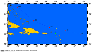
- This tool calculates the so-called 'Closest Point of Approach' (CPA) from the five-day forecast, in other words, it will show you how close the storm will pass by your island (see a small version on the right). Given the windfield of the storm you will be able to determine if you will get strong winds or not. Checking this from time to time when new advisories come in might also give you a feel for the trend in forecasted tracks; is it expected to come closer or further from you...? This tool is also updated automatically when new advisories come in (every six hours). There is also a Pacific version, for islands/towns/cities in Hawaii, Mexico and USA West Coast.
My Satellite
- Viewing close-up satellite images of your island is easier then ever! In a few clicks you will see a high resolution satellite image centered on your island. You can select from a visible (showing clouds), enhanced infra-red (showing clouds/rain) and water vapor ('air currents') images at different zoom factors. You can even create a loop of the last six images.
Miscellaneous
- The practical guide contains a lot of information as well on for example unit coversions, definitions of tropical systems, hurricane names for the next 6 years, etc. etc. The Satellite Imagery page shows a few detailed satellite images of the Caribbean and Central Atlantic. Also, the Quick Hurricane Web Resource Navigator (QHWRN) will give you fast access to the latest advisories, (storm centered) satellite images, model forecasts and more.
|
|
