
|
|
Climatologyof Caribbean Hurricanes |
|
|
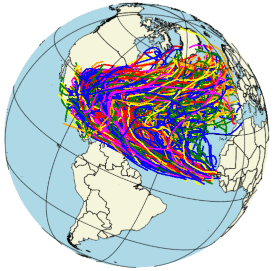 The climatology section consists of historical analyses of the past 150+ years, focusing on the Caribbean Islands. Almost 1900 storm tracks* have been analyzed for 4 specific regions: Atlantic (=all storms), Eastern Caribbean, Western Caribbean and the Bahamas/Turks & Caicos region as well as for over 50 islands/locations:
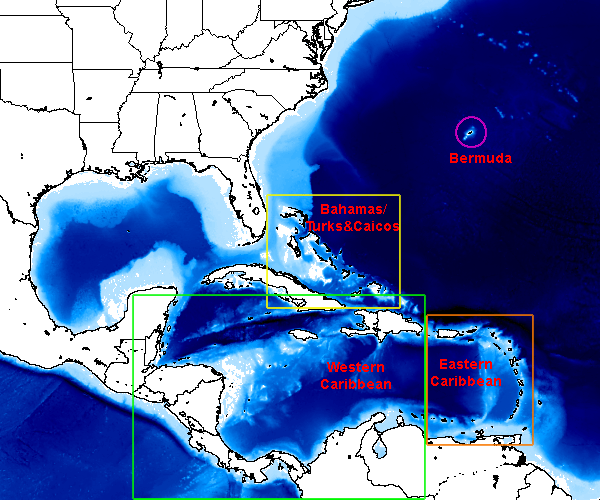
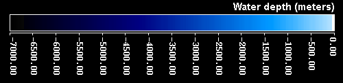
There are several ways to navigate the 600+ pages in this section. Below is a 'clickable' bathymetry map which takes you a more detailed map of the region of interest where you can easily locate your island of interest. The quickest way though is to use list of regions and islands below the maps. From there you can select the first three sections (see above): map (island location map, only for regions), all (tracks of all storms), dec (tracks of all storms plotted per decade), peak (peak of the season) and 5yr (5 year analyses).
| Regions Map | |
| |
| Regions: | |
|
Atlantic (any) all dec peak 5yr Eastern Caribbean map all dec peak 5yr |
Western Caribbean map all dec peak 5yr Bahamas \ Turks & Caicos map all dec peak 5yr |
| Islands: | |
|
Anguilla all dec peak 5yr Antigua all dec peak 5yr Aruba all dec peak 5yr Bahamas: Abaco all dec peak 5yr Bahamas: Bimini all dec peak 5yr Bahamas: Exuma all dec peak 5yr Bahamas: Grand Bahama all dec peak 5yr Bahamas: Inagua all dec peak 5yr Bahamas: Nassau, New Providence all dec peak 5yr Bahamas: San Salvador all dec peak 5yr Barbados all dec peak 5yr Barbuda all dec peak 5yr Belize: Ambergris Caye all dec peak 5yr Bermuda all dec peak 5yr Bonaire all dec peak 5yr BVI: Anegada all dec peak 5yr BVI: Tortola all dec peak 5yr BVI: Virgin Gorda all dec peak 5yr Cayman Islands: Cayman Brac all dec peak 5yr Cayman Islands: Grand Cayman all dec peak 5yr Cayman Islands: Little Cayman all dec peak 5yr Cuba: Guantanamo Bay all dec peak 5yr Cuba: Habana all dec peak 5yr Curacao all dec peak 5yr Dominica all dec peak 5yr Dominican Republic: Puerta Plata I. all dec peak 5yr Dominican Republic: Punta Cana all dec peak 5yr Dominican Republic: Santo Domingo all dec peak 5yr Grenada all dec peak 5yr Guadeloupe all dec peak 5yr |
Haiti: Port au Prince all dec peak 5yr Honduras: Guanaja all dec peak 5yr Honduras: Roatan all dec peak 5yr Jamaica: Kingston all dec peak 5yr Jamaica: Montego Bay all dec peak 5yr Key West, USA all dec peak 5yr Martinique all dec peak 5yr Mexico: Cancun all dec peak 5yr Mexico: Cozumel all dec peak 5yr Montserrat all dec peak 5yr Nevis all dec peak 5yr Puerto Rico: Culebra all dec peak 5yr Puerto Rico: Mayaguez all dec peak 5yr Puerto Rico: San Juan all dec peak 5yr Puerto Rico: Vieques all dec peak 5yr Saba all dec peak 5yr St.Barths all dec peak 5yr St.Eustatius all dec peak 5yr St.Kitts all dec peak 5yr St.Lucia all dec peak 5yr St.Maarten/St.Martin all dec peak 5yr St.Vincent all dec peak 5yr Tobago all dec peak 5yr Trinidad all dec peak 5yr Turks & Caicos: Grand Turk all dec peak 5yr Turks & Caicos: Provo all dec peak 5yr Turks & Caicos: South Caicos all dec peak 5yr USVI: St.Croix all dec peak 5yr USVI: St.John all dec peak 5yr USVI: St.Thomas all dec peak 5yr |
* Analyses are based on 'best track' data taken from the National Hurricane Center's North Atlantic hurricane database reanalysis project (HURDAT2, dated May 25, 2020) created by the Hurricane Research Division, AOML, NOAA. Data analyses and map creation was done with IDL
Copyright © 2020 Caribbean Hurricane Network. All Rights Reserved
Note that copyright applies to the entirety of this site.
| Back to top |