 |
Climatology
of Caribbean Hurricanes |
|
|
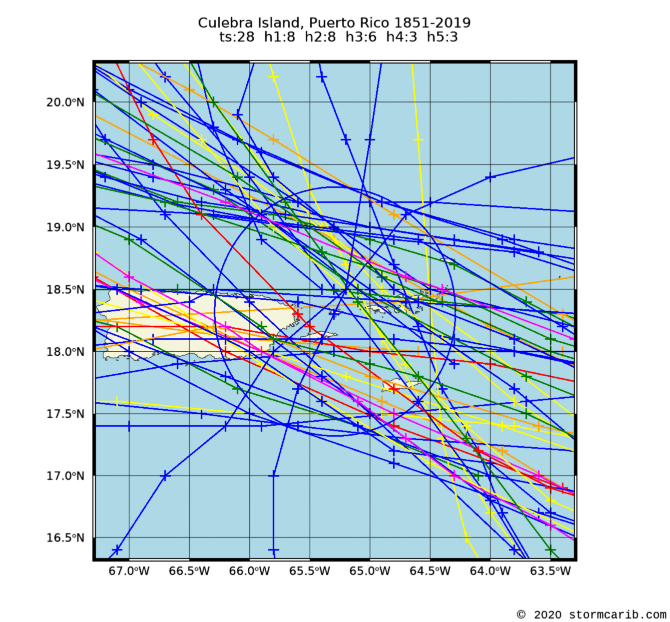
Culebra Island, Puerto Rico (TJCL)
Location: 18.32N 65.29W
Tropical systems passing within 60nm (= 69mi.) of the island. Used latitude/longitude coordinates (18.32N, 65.29W) might not be the center of the island. Often the location of the island weather station was used, which is normally at the airport.
Please note that not only hurricanes (h1-h5) are included but also tropical storms (ts). Wind/category reported is maximum measured while the system moved through region (box). Each category storm has its own color (see color bar below; ts=tropical storm; h1=category 1 hurricane; etc., see the guide for definitions). Different projections can be selected, the island projections are most zoomed in (select if you want to see how close the systems passed by the island [not available for regions]), while the world projection most zoomed out (select when you want to see the complete path of the storm). Winds are in miles per hour. It is also calculated how close the center of the storm came to the island, the so-called closest point of approach (cpoa, in miles).
Below you can see all stormtracks since 1851 for Culebra (for more details about individual storms skip to another page where storms are separated per decade). In the climatology section there is also a weekly analysis of the data which shows when the real peak of hurricane season is for Culebra and a five-year analysis to find out if more storms have passed close by Culebra recently.
Projection: Island | Caribbean | Atlantic | World |
![[ts=tropical storm; h1=category 1 hurricane; etc.]](colorbar.png)
| 1851 - 2019 |
 |
    date     wind  cat. cpoa  name
 5 Sep 1852    81   h1   57   UNNAMED
24 Sep 1852    81   h1   43   UNNAMED
29 Oct 1867   115   h3    4   UNNAMED
22 Aug 1871   115   h3   34   UNNAMED
13 Sep 1876   115   h3   19   UNNAMED
28 Nov 1878    69   ts   22   UNNAMED
14 Aug 1879    46   ts   61   UNNAMED
23 Aug 1881    69   ts   66   UNNAMED
 3 Sep 1889   104   h2   32   UNNAMED
15 Oct 1891    69   ts   39   UNNAMED
16 Aug 1893   115   h3   36   UNNAMED
13 Oct 1894    98   h2   17   UNNAMED
28 Oct 1898    58   ts   59   UNNAMED
 8 Aug 1899   144   h4   45   UNNAMED
31 Aug 1900    52   ts   65   UNNAMED
11 Sep 1901    58   ts    1   UNNAMED
10 Sep 1908    69   ts   50   UNNAMED
 6 Sep 1910    98   h2   56   UNNAMED
13 Jul 1916    52   ts   28   UNNAMED
22 Aug 1916   109   h2   32   UNNAMED
10 Oct 1916   109   h2   52   UNNAMED
 3 Sep 1919    46   ts   69   UNNAMED
19 Aug 1924    46   ts    7   UNNAMED
29 Aug 1924   109   h2   27   UNNAMED
 3 Aug 1928    40   ts   49   UNNAMED
13 Sep 1928   161   h5   37   UNNAMED
17 Aug 1931    40   ts   21   UNNAMED
11 Sep 1931    86   h1   12   UNNAMED
27 Sep 1932   144   h4   18   UNNAMED
26 Jul 1933    86   h1   17   UNNAMED
 8 Aug 1938    63   ts   45   UNNAMED
 5 Aug 1940    46   ts   44   UNNAMED
14 Aug 1943    46   ts   39   UNNAMED
 3 Sep 1949    46   ts   14   UNNAMED
23 Aug 1950    46   ts   55   BAKER
12 Aug 1956    98   h2   45   BETSY
 5 Sep 1960   127   h3   63   DONNA
16 Sep 1975    40   ts   44   ELOISE
 4 Sep 1979    52   ts   15   FREDERIC
 8 Sep 1981    58   ts   33   GERT
 7 Nov 1984    69   ts    5   KLAUS
18 Sep 1989   138   h4   15   HUGO
 7 Oct 1990    46   ts   66   KLAUS
16 Sep 1995   109   h2   12   MARILYN
 8 Jul 1996    86   h1   30   BERTHA
21 Sep 1998   115   h3   26   GEORGES
21 Oct 1999    69   ts   32   JOSE
22 Aug 2000    75   h1   29   DEBBY
22 Aug 2001    58   ts   17   DEAN
15 Sep 2004    69   ts   45   JEANNE
11 Dec 2007    46   ts    8   OLGA
22 Aug 2011    75   h1   23   IRENE
 6 Sep 2017   178   h5   33   IRMA
20 Sep 2017   161   h5   38   MARIA
29 Aug 2019    86   h1   13   DORIAN
24 Sep 2019    46   ts    1   KAREN
|
|
Culebra Island, Puerto Rico: all dec peak 5yr rank
Copyright © 2020 Caribbean Hurricane Network. All Rights Reserved