 |
Climatology
of Caribbean Hurricanes |
|
|
Santo Domingo, Dominican Republic (MDSD)
Location: 18.47N 69.90W
Tropical systems passing within 60nm (= 69mi.) of the island. Used latitude/longitude coordinates (18.47N, 69.90W) might not be the center of the island. Often the location of the island weather station was used, which is normally at the airport.
Please note that not only hurricanes (h1-h5) are included but also tropical storms (ts). Wind/category reported is maximum measured while the system moved through region (box). Each category storm has its own color (see color bar below; ts=tropical storm; h1=category 1 hurricane; etc., see the guide for definitions). Different projections can be selected, the island projections are most zoomed in (select if you want to see how close the systems passed by the island [not available for regions]), while the world projection most zoomed out (select when you want to see the complete path of the storm). Winds are in miles per hour. It is also calculated how close the center of the storm came to the island, the so-called closest point of approach (cpoa, in miles).
Below you can see all stormtracks for each decade since 1851 for Santo Domingo. All storms since 1851 in one image [colored spaghetti] can be found elsewhere. In the climatology section there is also a weekly analysis of the data which shows when the real peak of hurricane season is for Santo Domingo and a five-year analysis to find out if more storms have passed close by Santo Domingo recently.
Projection: Island | Caribbean | Atlantic | World |
![[ts=tropical storm; h1=category 1 hurricane; etc.]](colorbar.png)
| 2010 - 2019 |
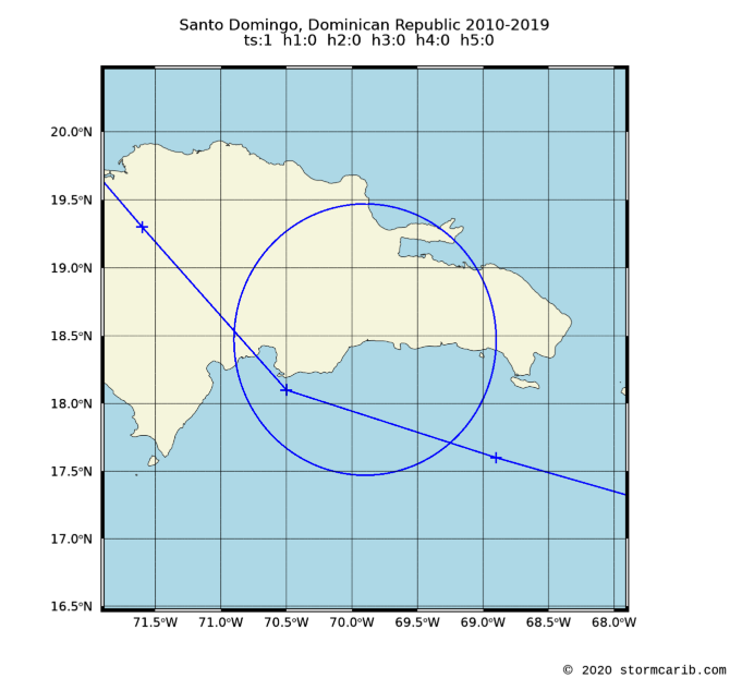 |
    date     wind  cat. cpoa  name
10 Jul 2018    40   ts   36   BERYL
|
|
| 2000 - 2009 |
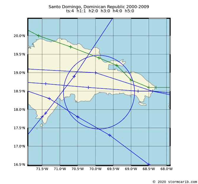 |
    date     wind  cat. cpoa  name
 7 Dec 2003    46   ts   55   ODETTE
16 Sep 2004    75   h1   58   JEANNE
23 Oct 2005    52   ts   60   ALPHA
12 Dec 2007    58   ts   33   OLGA
16 Aug 2008    46   ts    7   FAY
|
|
| 1990 - 1999 |
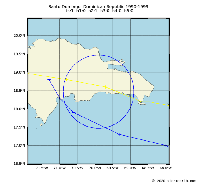 |
    date     wind  cat. cpoa  name
16 Aug 1993    40   ts   55   CINDY
22 Sep 1998   109   h2   11   GEORGES
|
|
| 1980 - 1989 |
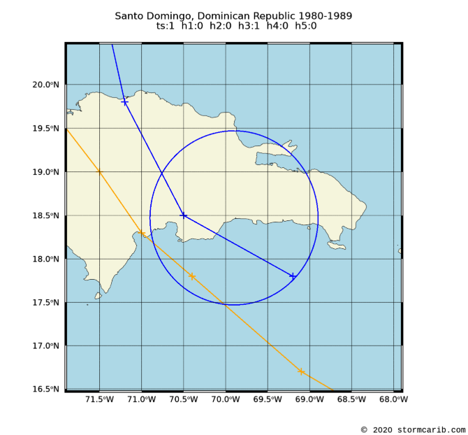 |
    date     wind  cat. cpoa  name
 7 Oct 1985    40   ts   18   ISABEL
23 Sep 1987   121   h3   56   EMILY
|
|
| 1970 - 1979 |
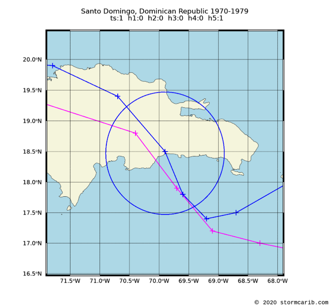 |
    date     wind  cat. cpoa  name
31 Aug 1979   173   h5   13   DAVID
 5 Sep 1979    46   ts    1   FREDERIC
|
|
| 1960 - 1969 |
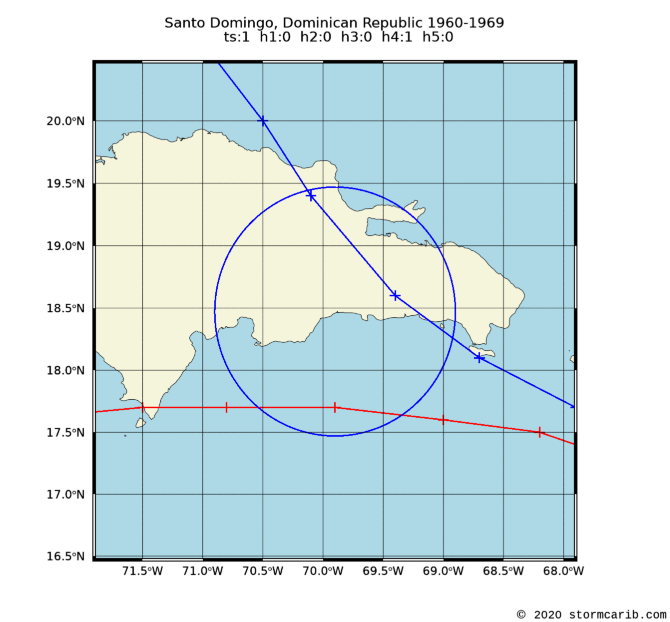 |
    date     wind  cat. cpoa  name
27 Sep 1963    63   ts   31   EDITH
10 Sep 1967   138   h4   53   BEULAH
|
|
| 1950 - 1959 |
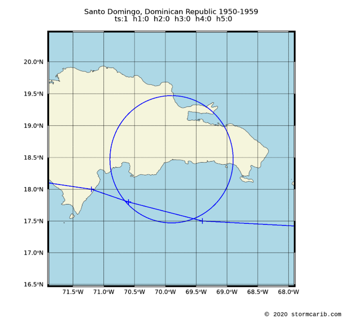 |
    date     wind  cat. cpoa  name
14 Sep 1958    58   ts   56   GERDA
|
|
| 1940 - 1949 |
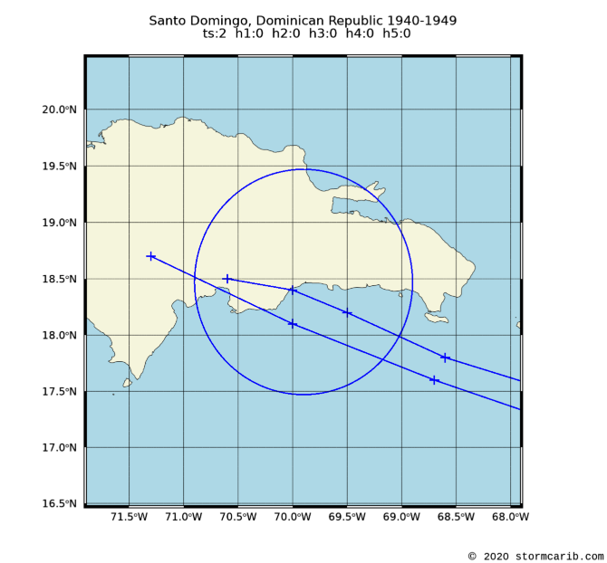 |
    date     wind  cat. cpoa  name
 4 Aug 1945    58   ts   26   UNNAMED
22 Sep 1949    63   ts    7   UNNAMED
|
|
| 1930 - 1939 |
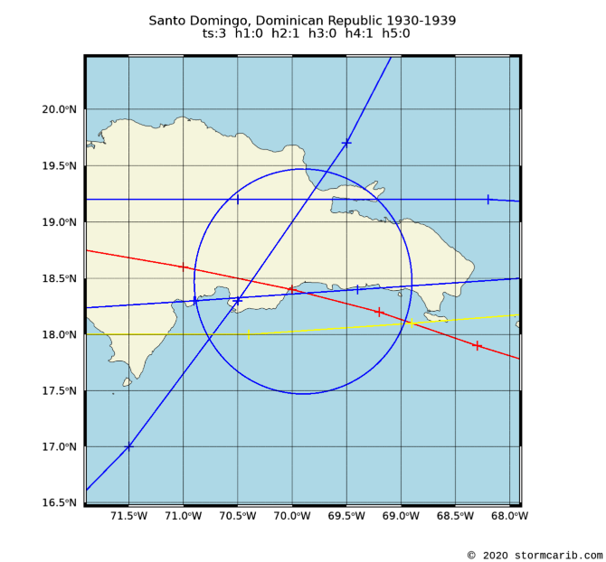 |
    date     wind  cat. cpoa  name
 3 Sep 1930   155   h4    6   UNNAMED
11 Sep 1931    63   ts    7   UNNAMED
 7 May 1932    46   ts   26   UNNAMED
27 Sep 1932   104   h2   30   UNNAMED
 9 Aug 1938    40   ts   50   UNNAMED
|
|
| 1920 - 1929 |
 |
    date     wind  cat. cpoa  name
  NO STORMS PASSED BY THIS PERIOD
|
|
| 1910 - 1919 |
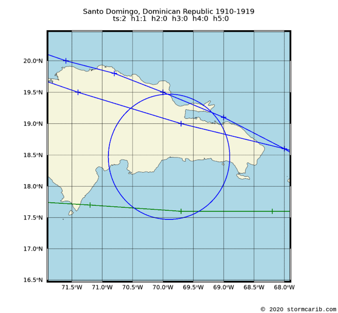 |
    date     wind  cat. cpoa  name
 7 Sep 1910    86   h1   59   UNNAMED
23 Aug 1916    69   ts   39   UNNAMED
 4 Sep 1919    46   ts   63   UNNAMED
|
|
| 1900 - 1909 |
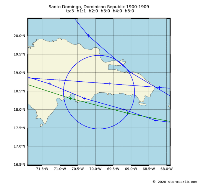 |
    date     wind  cat. cpoa  name
 1 Sep 1900    46   ts   18   UNNAMED
 7 Jul 1901    69   ts   66   UNNAMED
12 Sep 1901    46   ts   17   UNNAMED
23 Aug 1909    92   h1   25   UNNAMED
|
|
| 1890 - 1899 |
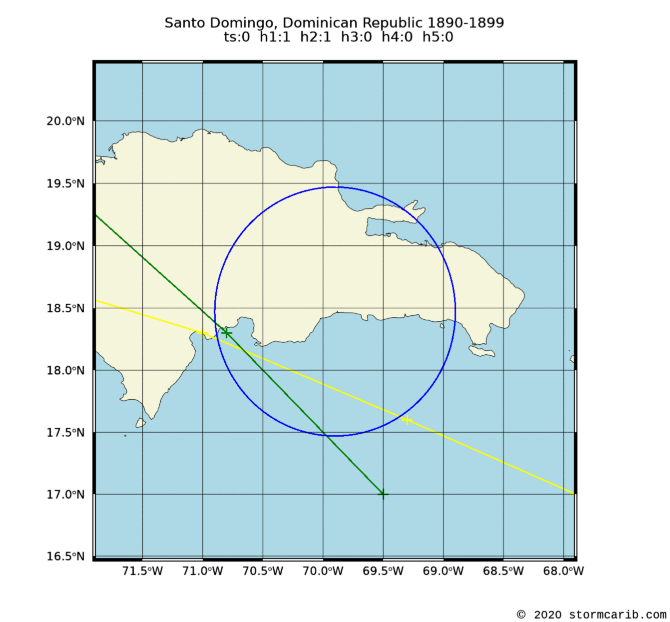 |
    date     wind  cat. cpoa  name
22 Sep 1894   109   h2   39   UNNAMED
28 Jul 1899    81   h1   51   UNNAMED
|
|
| 1880 - 1889 |
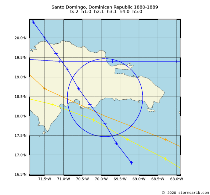 |
    date     wind  cat. cpoa  name
 6 Sep 1883   127   h3   29   UNNAMED
15 Aug 1886    98   h2   44   UNNAMED
11 Oct 1887    69   ts   64   UNNAMED
19 Aug 1889    58   ts   28   UNNAMED
|
|
| 1870 - 1879 |
 |
    date     wind  cat. cpoa  name
14 Sep 1876    81   h1   18   UNNAMED
|
|
| 1860 - 1869 |
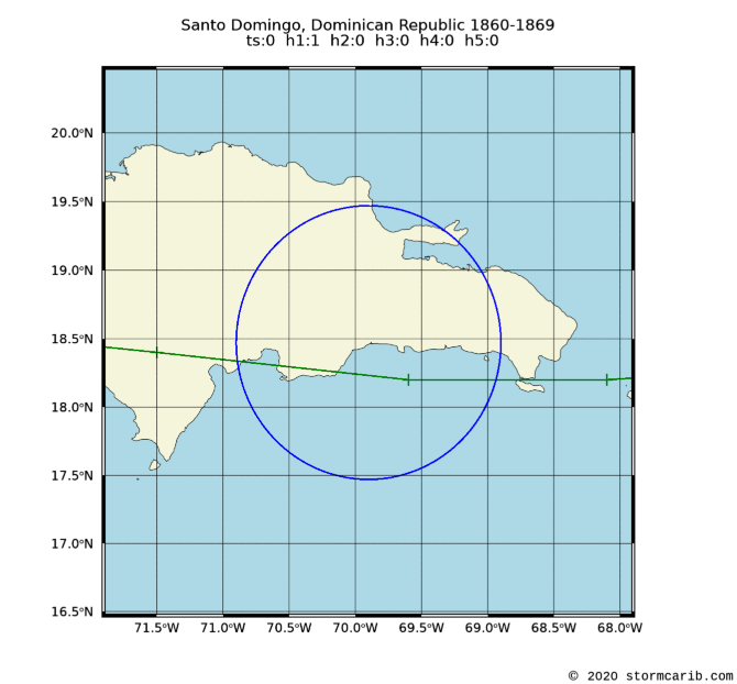 |
    date     wind  cat. cpoa  name
30 Oct 1867    92   h1   16   UNNAMED
|
|
| 1850 - 1859 |
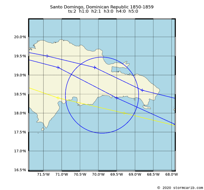 |
    date     wind  cat. cpoa  name
19 Aug 1851   104   h2   23   UNNAMED
 6 Sep 1852    58   ts   39   UNNAMED
27 Aug 1855    58   ts    8   UNNAMED
|
|
Santo Domingo, Dominican Republic: all dec peak 5yr rank
Copyright © 2020 Caribbean Hurricane Network. All Rights Reserved