
|
|
Caribbean Hurricane Network- Updates from the Islands - |
|
|
Archive of weather discussions and eye witness reports from the Caribbean Islands in the 2002 Atlantic Hurricane Season. Postings are in reverse chronological order (so it might be easier to start reading at the bottom of this page and work your way up to follow the timeline). For current events look here.
Index: | Season Preview | Arthur | Bertha | Cristobal | Dolly | Edouard | Fay | Gustav | Hanna | Isidore | Josephine | Kyle | Lili | Fourteen
The heart of the Caribbean Hurricane Network are the personal reports send in by the special hurricane correspondents on the islands. Find out what happened on your favority island during the 2002 Hurricane Season by following the links below. | |
|
- Culebra (PR) (Apr 21) - Vieques (PR) (Apr 19) - Tortola (Apr 12) - Anguilla (Apr 7) - St.Kitts (Mar 31) - Antigua (Mar 16) - Nevis (Feb 12) - St.Thomas (Dec 24) - Cayman Islands (Dec 16) - St.Maarten/St.Martin (Dec 9) - Grenada (Dec 8) - Barbados (Oct 28) - Jamaica (Oct 15) - Florida Keys (Oct 14) - Puerto Rico (Oct 14) - Saba & Statia (Oct 12) |
- Bermuda (Oct 4) - Cuba (Oct 2) - St.Vincent & Grenadines (Sep 30) - Haiti (Sep 29) - Dominican Republic (Sep 27) - Bahamas (Sep 25) - Trinidad & Tobago (Sep 24) - St.Croix (Sep 24) - Mexico (incl. Cozumel & Cancun) (Sep 24) - St.John (Sep 23) - Martinique (Sep 23) - St.Lucia (Sep 23) - Dominica (Sep 23) - Guadeloupe (Sep 22) - Bonaire (Aug 7) |
| - - - Fourteen - - - |
October 14, 2002 12:45PM EDT - Tropical Depression Fourteen
After the last advisory was issued on Kyle I was hoping that that was it for the 2002 season. But no, today another tropical depression formed about 150 miles southwest of Grand Cayman. It is expected to move over western Cuba... What is up with this area this year? Seems that all storms moved through the area of Cayman and Cuba! In any case, conditions are not really favorable for quick strengthening, we'll see when it becomes a named storm or worse. For now, it looks like it will be more like a nuisance for islands on it's path (Cuba, Bahamas) rather then a threat.
| - - - Lili - - - |
October 1, 2002 3:00PM EDT - Cuba
At this moment the center of Lili is passing quickly over the western tip of Cuba (about 115 miles west of Habana). It has recently been upgraded to a category-2 hurricane, packing winds near 100 mph. The good thing is that it's moving so fast, so the amount of rainfall will be relatively limited. That is a good thing, since the soil was already saturated by Isidore last week. I am hoping to get the first reports from Cuba in soon. Reports from Cayman indicate that they (incl. Cayman Brac and Little Cayman, which were in the path of the storm) did quite well. See above for reports from the other islands.
What's next? It is expected to strengthen somewhat, and move a little faster. In about 2 days Lili is expected to make landfall in Texas or Louisiana. The numerical models agree all pretty well, so it is not expected that Lili will make a little detour over the Yucatan like Isidore. It's path will not really discussed here much further, since it left the Caribbean. However, the tools on this website to calculate how far it is or how close it can get can still be used, in addition to the storm-centered .
September 30, 2002 6:05PM EDT - Isidore II?
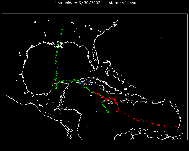 The path of Lili looks very similar to Isidore's, just last week! I quickly made the tracking map on the right (click on it for enlargement) showing both Isidore (green) and Lili (track=red, forecast=blue). Just like Isidore, Lili battered Little Cayman and Cayman Brac, and is on it's way to Isle of Youth, Cuba. Main difference are though that Lili should move a lot quicker, is a lot smaller, though very powerful too, and shouldn't make a little detour over the Yucatan.
Lili passed straight over Little Cayman and Cayman Brac earlier today. I was looking at the storm-centered , while it passed over the islands, and it looked like that Lili got a lot stronger, almost developing an eye just after it passed over. Good timing in this case. The center also stayed far enough (about 75 miles) from Grand Cayman to cause major problems (see the reports from the Cayman Islands. I just got a report in from Cayman Brac that they did encounter hurricane force winds, but apparently istwasn't as bad as Isidore. So good news!
So next is Cuba, where is should cross over the western top tomorrow. Right now Lili is already stronger then Isidore was when it made landfall. However, since this system is smaller and should move faster I don't expect it to be much worse. But small hurricanes have the capability to strengthen quickly, so be on the alert! See above for more updates from the islands by the special hurricane correspondents.
September 30, 2002 11:05AM EDT - Cayman...
And Lili is still battering not gone! Just upgraded to a hurricane, it should have long left the Jamaica/Cayman area, but it has just been meandering around. But now it finally seems to move west/northwest at 10 mph. The center of the storm is now basically sitting over Cayman Brac and Little Cayman. It is expected to stay at least 90 miles from Grand Cayman. Since hurricane winds only extend out to 15 miles from the center they should be ok (they will feel tropical storm winds though). See above for reports from the Cayman's, Jamaica and other islands by the special hurricane correspondents.
September 27, 2002 12:15PM EDT - Jamaica...
The center is still kind of difficult to pin point on satellite imagery. Hurricane Hunters investigated the storm and centered the storm east of what was preiviously thought. The center of the storm is expected to pass over Jamaica in the next day or so ((closest point of approach for Kingston is just 7 miles in 23.5 hours). Be aware that the center of the storm is on the southwestern edge of the big blob on satellite imagery, not in the middle, as can be seen on the storm-centered the first bands of the storm are already touching Jamaica and the western tip of Haiti. Once Lili gets less sheared it might develop into a stronger system. It also looks like Lili is taking a more westernly path, brushing the southern coast of Cuba, and passing just 20 miles east of Cayman Brac in about 60 hours. See above for links to reports from the islands by the special hurricane correspondents.
September 27, 2002 1:15AM EDT - She's back!
This storm should have been long gone, but she is still sitting in the middle of the Caribbean Sea! Now satellite imagery indicate that there is a closed circulation again, so Lili, which was downgraded to a tropical depression or wave, has been upgraded to tropical storm status. I still don't see a real center on the storm-centered though.
The fact that it is now a tropical storm again doesn't really change what I wrote earlier, only that winds will be stronger. Hispaniola and Jamaica should still expect heavy rains and gusty winds. The center is expect to move over the eastern side of Jamaica (closest point of approach for Kingston is just 23 miles in 38 hours). See above for links to reports from the islands by the special hurricane correspondents.
September 26, 2002 12:30PM EDT - Lili dissipating!
And yes, indeed, Lili is now not more then a tropical wave, so the high winds are basically gone, but the rains are not. Right now the 'center' of this thing will move straight over Jamaica, with most of the bad weather to the north-east of the center, people in the Dominican Republic and Haiti shouldn't let their guard down either. Be prepared for a lot of rain, esp. since the system doesn't move that fast. View the reports by the local hurricane correspondents to see what the real conditions are.
September 25, 2002 12:10PM EDT - Where is the eye?
Lili remains poorly organized and has considerably weakened since yesterday. The exact center of low pressure is difficult to locate, and probably repositioning itself from time to time. Maximum sustained winds are now only near 45 mph. By the time it makes (is)land fall it is very unlikely that it will be a hurricane (let a lone a categary 2). So that's the good news.
On the other hand, it is a rather large system, with tropical storm winds extending outward to up to 115 miles from the center. Pretty impressive for such a disorganized tropical storm, or should we say, tropical wave? Also, since it isn't moving that fast anymore it will be a big rainmaker on some of the islands. Puerto Rico might luck out, since Lili is now moving more westward, but the Dominican Republic and Haiti, with it's mountainous terrain will most likely have to endure mudslides and flooding. Not the wind, but the rain will be the major problem.
Right now Lili is taking a little more westernly path then earlier forecasted, with the center passing west of Haiti, closer to Jamaica. This doesn't mean much since the brunt of the storm is to the north-east of the center, so Haiti (nor their neighbor the Dominican Republic) should abandon preparations. In about 20 hours or so I expect the weather to get worse for Hispaniola. Stay tuned, as reports by our special hurricane correspondents are coming in continuously from the islands.
September 24, 2002 5:25PM EDT - Weakening?
On satellite pictures Lili doesn't look as healthy and it hasn't strengthened since the last update (still 70mph winds sustained). It is hard to figure out where the center of circulation is since it is not really symetrical. However, since it has slowed down, it might still get it's act together and become a hurricane soon (which would only mean a little strengthening).
As it looks right now it is still heading for Haiti. Winds are expected near 95 mph (Category 2 hurricane) by the it gets there in about 48 hours. A tropical storm watch has been issued for the southern coasts of the Dominican Republic, and Haiti, from Putan Palenque westward to Tiburon (the western top of the Tiburon Peninsula of Haiti). For Haiti this might be upgraded to a hurricane watch.
Since tropical storm winds extend outward to up to 125 miles from the center, don't just focus on the center of the storm, like I do here :-), other islands should be on alert too. Esp. Jamaica, since it might take a more westernly path as currently forecasted. Stay tuned while the reports from the local hurricane correspondents are coming in.
September 24, 2002 12:30PM EDT - Over open waters
Lili has crossed the island chain (the center of the storm went over Mayreau, just in between Canouan and Union in the Grenadines, see the earlier map I made). The reports from the special hurricane correspondents indicate that most of the damage done by this tropical storm was north of the center. Barbados had considerable damage, as well as the northern and eastern side of St.Vincent. One of my correspondents sadly had to report at least 4 casualties on St.Vincent (though I haven't had any confirmation of that). In any case, cleanup is in full swing, and for the islands things should be back to normal soon.
Now Lili is over open water, with the warm sea surface temperatures there is lots of energy available to strengthen. It is now with 70 mph very close to hurricane strength. Despite the high SSTs, Lili is not expected to become a major category 3 hurricane, mostly because the storm is not that well organized and has a quite a-symmetrical look.
Where will it go...? The official 3 day forecast brings the storm over Haiti in about 2 days, though a more westernly track is very well possible, so people on Jamaica should be on alert as well. Also, this storm covers quite a large area. The outflow of this system is currently causing gusty weather over the northeastern islands like Antigua, St.Maarten/St.Martin, USVI and BVI, and soon Puerto Rico as well.
September 23, 2002 4:55PM EDT - It's Lili
Lili is now a tropical storm with winds near 60 mph (hurricane strength is 74 mph and up, see the practical guide for more info). Although it moved about 50 miles south of Barbados, the reports from Barbados by our special hurricane correspondents report widespread damage with uprooted trees and blown off roof tops. Power is still on on parts of the islands.
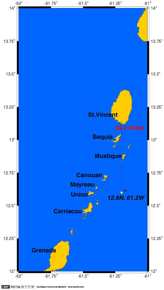
Currently the center of the storm is just 36 miles from St.Vincent, and they are already experiencing tropical storm force winds. The storm should move just south of St.Vincent (closest point of approach: 35 miles in 1 hour!), and about 50 miles north of Grenada (in 2 hours), going straight over the islands of the Grenadines in between (over Canouan, just south of Mustique, see this map, I quickly put together, showing the center of the storm (yellow dot), distance to St.Vincent and the islands of the Grenadines). It is important to note though that we shouldn't focus on the location of the center alone. Strong winds and torrential rainfall can expand a long way from the center (just take a look at the storm-centered ). Since it's forward speed is quite high at 20 mph so it should be over soon for these islands.
Where will it go from here...? Conditions are pretty favorable for Lili to strengthen more when it's in the Caribbean Sea, though it is not expected to become major storm like Isidore. Right now the three day forecast takes the center of the storm very close to Haiti in 3 days, but since these long range forecasts are prone to large errors, anywhere from Jamaica to the USVI should pay close attention to this one.
September 23, 2002 1:15AM EDT - Still just number 13
The depression is still not Lili. However, it might become a named storm in 24 hours, and a hurricane in 3 days. Earlier it looked like the storm will take a little more northernly path, passing just south of the USVI/BVI, now the official forecasts takes the center of the depression 23 miles south of Barbados in 14 hours and passing over St.VIncent in 20 hours. It is moving quite rapidly, so by the time it has crossed the islands, it might still not be a tropical storm. Sofar, this will be more then a nuisance bringing some windy and rainy conditions to some of the islands.
Sat, 21 Sep 2002 18:38:33 -0400 - tropical depression 13
| - - - Kyle - - - |
October 12, 2002 5:55PM EDT - Finally...
After having been upgraded to a tropical storm for the fifth time yesterday, and making circles in the Atlantic for 3 weeks, the National Hurricane Center today issued the 89th and hopefully final advisory on Kyle! It is one of the weirdest tracks I have seen. (see: Unisys.com). Hurricane Question of the Day: Did it ever make landfall?
October 9, 2002 12:25PM EDT - Still Kyle
Yes, he is still here. This thing circled around Bermuda, has been downgraded and upgraded a couple of times, and lo and behold it is threathening some land. Right now it is a tropical depression with winds near 35 mph. On satellite imagery it's hardly noticable due to the minimal convection associated with this system. Right now it is expected to make 'landfall' as a tropical depression in Florida in about 48 hours. Nothing major will happen. Will this then finally be the end of Long Lived Kyle? We'll see.
September 21, 2002 1:25PM EDT - Kyle
The subtropical depression is upgraded to tropical storm Kyle. Still no threat to any land.
September 20, 2002 17:25PM EDT - Tropical Depression Twelve
And another depression formed over 800 miles east-southeast of Bermuda. It is not expected to become a major player or threaten any land.
| - - - Josephine - - - |
September 17, 2002 17:25PM EDT - Tropical Depression Eleven
A new tropical depression formed in the Atlantic. It's center is located about 700 miles east from Bermuda and moving away, bothering no-one, except when you are on a ship in that neighborhood.
| - - - Isidore - - - |
September 24, 2002 5:05PM EDT - Heading for...
Isidore is over sea again heading for the US Gulf coast. The latest advisories still indicate it making landfall in Louisiana, close to New Orleans. Since this website is focussed on the Caribbean only, it will not further discussed here nor will there be any local reports. However, you can still check the distance from your hometown to the eye of the storm, or figure out how close it can get and how long it will takes to get to you! You can also view a high-resolution storm-centered . A good source of information is the Yahoo-website.
September 23, 2002 1:10AM EDT - Isidore inland
This storm keeps surprising us. It should have stayed just offshore the Yucatan peninsula, but it made landfall after all. If you would have told me a couple of days ago while it was passing by Jamaica that it would make landfall in the Yucatan Peninsula I would have not believed it at all! The good thing (as long as you don't live there) is that the longer it stays over land, and the farther it goes inland, the weaker the storm gets. It is expected to return to the Gulf of MExico, where it can restrengthen quite rapidly becasue of the warm sea surface temperatures. Where it will go? Again, still a big question. It looks more likely though that it won't make landfall again in Mexico, but it's more likely to make landfall in the US. But that's still days away...
September 21, 2002 1:30PM EDT - The first big one
Isidore is now a category 3 hurricane on the Saffir Simpson Hurricane Insensity Scale, packing winds near 12o mph. It pummeled the western side of Cuba. Since I have not received many reports from my correspondents on Cuba, more news can be found on the Yahoo-website.
This storm has taken a much more westernly course then earlier thought. Although it is expected that the eye will stay just north of the Yucatan peninsula, it will be very close. Just a very little dip south and the eye, with the strongest wind surrounding it, will make landfall. Right now it is not moving at all, which is not good either because of the high rainfall accumulation. The center of Isidore is just 70 miles from Cancun, and it is forecasted to get as close as 50 miles (see the tools above).
September 19, 2002 12:23PM EDT - Still Cayman
Come on girl, move! It looks like Isidore is a lot closer to Grand Cayman then earlier thought. The storm is wobbling around, and definately taking a more westernly path. Right now it's only 50 miles from Grand Cayman (instead of 110 miles as I wrote yesterday). They are for sure experiencing tropical storm force winds. See eyewitness reports. The tail of the storm is slowly leaving Jamaica. First reports from Jamaica aren't bad at all. The storm is now near hurricane strenght, but esp. with the slow forward speed the rains associated with this system will be the biggest threat, esp. to the mountainous areas in Cuba, where it is expected to cross over the western part (right now it looks like that the center will stay about 100 miles from Habana). Since it looks like it travels more west, the Floriday Keys should be ok. Where it will make landfall in the US (or maybe even Mexico) is still very uncertain. The different computer models don't really agree with each other.
September 19, 2002 0:30AM EDT - Cayman...
THe center of Isidore will be passing by Cayman Brac withing 15 miles in the next hour or so. Grand Cayman lucked out, since the center of the storm won't get closer then 110 miles or so in the next 7 hours. Looking at the satellite loop ( view storm centered ) Cayman Brac and Little Cayman are getting the full force of the storm, which is now near 60 mph (hurricane force is 74mph and up). Although it has passed Jamaica already they are still experience bad weather. The tail of this storm is quite powerful.
What's next... Cuba. It is expected to pass as a hurricane over the western side of Cuba. Cuba is a very large island, it's closest point of approach with Havana, Cuba is forecasted to be about 40 miles (in 30 hours) and Montega Bay 284 miles. In 30 hours it is expected to be close to hurricane strength. So it is not expected to be a 'catastrophical' storm windwise for Cuba, though if Isidore keeps moving this slow, or even slows down more, the torrential downpours could become a big problem.
After Cuba...? Who knows. Rigth now it looks like it will pass well to the wet of the Keys though. See above for reports by the special hurricane corresponendts on the islands.
September 18, 2002 0:52AM EDT - Isidore
I don't know what the people at the Hurricane Center are thinking, but to me Tropical Depression Ten really looks like a tropical storm on satellite pictures. So I am (unofficially) upgrading TD Ten to Tropical Storm Isidore.
The three day forecast show a little more easternly path compared to the last forecast (6 hours ago). Now Isidore will pass to the east from the Cayman Islands. It's closest point of approach for Grand Cayman is now about 50 miles, in 33 hours. Don't let me mislead you since I only look at the center. Bad weather will arrive hours ahead of the storm. It is also passing closer to the west coast of Jamaica. After Jamaica and Cayman, it will be Cuba... Stay tuned for more...
September 17, 2002 17:25PM EDT - Getting organized...
We might have tropical storm Isidore in the next 24 hours... The thing hasn't moved much, and has become better organized. It is bringing bad weather to Jamaica. It is still heading for the Cayman Islands, it's closest point of apprach with Cayman will be just 33 miles, in 38 hours. By that time Isidore is expected to be packing 55 knots winds, still just a tropical storm.
September 17, 2002 12:05PM EDT - It's back!
The hurricane hunters found a closed circulation, so the tropical wave is reclassified as a tropical depression. It is currently about 145 miles south of Jamaica. As it looks right now it will pass south-west of the Cayman Islands (cpoa: 78 miles in 40 hours). It might be a named storm by now. In any case the 'brunt' of this thing is to the north/east of the center, so Jamaica will likely experience some gusty weather.
September 16, 2002 12:15PM EDT - Gone, but not really
Well, it looks like we lucked out. The depression more or less dissapated over Venezuela. It didn't become the 'big one' I feared. Now it is a strong tropical wave, which will still bring some gusty weather to Jamaica, Haiti/Dominican Republic and later the Cayman's.
September 14, 2002 10:25PM EDT - Tropical Depression Ten
Tropical depression number Ten formed in the southern windward islands, very close to Trinidad. Right now it's not much, but it might become the first big one... Jamaica, Hispaniola, pay attention to this storm... More later.
Sat, 14 Sep 2002 01:07:33 -0300 - TD #10?
|
Good morning. While TS Hanna continues her
meanderings in the Gulf of Mexico, the Lesser Antilles is bracing for the
strongest tropical wave of the season approaching at breakneck speed (20-25
mph).
Here in the NE Caribbean, we are expecting gusty
winds, thunderstorms, and heavy rainfall at times. While a surface level
circulation hasn't been identified yet, I believe this one will strengthen to TD
status by Sunday night. Ahead of that is too early to tell as there is still
some upper level shearing winds, which have protected the Eastern Caribbean very
well so far this season, which would inhibit development after 48-72 hours.
While we really do not need the gusty winds, the rain is much needed due to
semi-drought conditions. Oh well, a "little" excitement is always good and helps
to alleviate complacency which is all too prevalent at the moment.
Behind this wave, still 7-9 days away, is another
wave southwest of the Cape Verde Islands with cyclonic turning and a low near
10N. This one could be interesting down the road. After all, we are in the
middle of the Cape Verde season regardless of El Nino.
Hope all is well with everyone and let's keep our
fingers crossed our good luck, with a wary eye, continues!
Dave
St. Thomas
|
| - - - Hanna - - - |
September 12, 2002 12:40PM EDT - Tropical Depression Nine
And another tropical depression formed. This time in the Gulf of Mexico, off the Florida coast (Pensacola). Again, this one is not threathening any of the islands so it will not be discussed here. But you can still use the tools above to see how close it is or to check how close it can get.
| - - - Gustav - - - |
September 8, 2002 2:00PM EDT - Subtropical Depression Eight
Way off the eastern coast of the US a new depression formed. This one is actually a 'subtropical' depression, not a 'tropical' depression, since it has a cold vs. warm core/center. It is moving towards the North Carolina coast. Although it is not expected to become a hurricane, it might become a named storm. Use the tools above to see how close it is or to check how close it can get.
| - - - TD Seven - - - |
September 7, 2002 2:15PM EDT - Tropical Depression Seven
A new tropical depression formed in the Atlantic. It's not threathening any land. This looks more like something for the records. Wonder if it ever will become a tropical storm (Gustav). So far it looks like it will Bermuda as well.
| - - - Fay - - - |
September 4, 2002 5:35PM EDT - Tropical Depression Six
Tropical Depression Number Six formed in the northwestern Gulf of Mexico, off the coast of Texas, about 100 miles southeast of Galveston. Since it is not threatening any of the Caribbean Islands it will not really discussed here. However, the tools above, which are continuously updated, might still be helpful for the people in the warning areas. Find out how close it is from your location or how close it can get.
| - - - Edouard - - - |
September 2, 2002 2:35AM EDT - Edouard
Out of Tropical Depression Number Five Edouard formed off the Florida/Georgia, USA coast. Since it is, and probably will not threaten any of the Caribbean Islands it will not really discussed here. However, the tools above, which are continuously updated, might still be helpful for the people in the warning areas. Find out how close it is from your location or how close it can get. And yes, indeed, welcome back Huck, longtime correspondent from St.Thomas!
| - - - Dolly - - - |
September 3, 2002 1:05PM EDT - Bye, bye, Dolly
Dolly didn't make it by far to the islands. Yeah! Also, it will stay well east of Bermuda (by last accounts about 750 miles). And as a side note, Dr. Gray and his team at Colorado State have further downgraded their forecast of Hurricane Activity for the remainder of the season. They only foresee 4 more tropical storms for this year, 3 might become a hurricane, one of these might reach category 3 or higher status (see full report). So looking good... But, as always, we only need one bad one to spoil a season (year). Unfortunately S. Korea is not as lucky. A powerful typhoon made landfall killing 113 people. See more news.
Sun, 1 Sep 2002 22:16:17 -0300 - Dolly
|
Thankfully, Dolly has decided to make her move to
the Northwest but she is still below 20N so this system still bears watching
just a bit longer. You never know.
Definitely, Dolly woke up the Caribbean as I
believe complacency had reared it's ugly head. So, I believe the good news from
Dolly, other than she will probably have no effect on the caribbean, is she made
people sit up and take notice. After all, we are only entering the beginning of
the traditionally most active month (September).
Does this mean we will have late storms this year,
say mid-October and even into November? Possibly. However, if the, unusual for
so late in the season, WSW wind shear which has persisted and protected
the Caribbean so far this year
lingers on, it's entirely possible there will be no
land-falling tropical systems in the Eastern Caribbean this 2002 hurricane
season.
As far as rain for St. Thomas, once again another
wave, while looking very ominous in the beginning and close by at that, has
failed to give the Virgin Islands much anticipated rainfall in the amounts
expected. Yes, we did receive more over the last few days than we've received in
weeks and we are thankful for that. But, on a personal note, this wave cost me
US$300 because I had to buy a truckload of water (21-tons aka 5,200 gallons
because the anticipated rainfall amount failed to materialize. Oh well, happens
sometimes!
On a happy note, welcome back Huck Jordan,
long-time correspondent from St. Thomas!!!
Dave
|
August 31, 2002 12:02PM EDT - Dolly weakening
Tropical storm Dolly, which is still about 1200 east of the islands, is barely a tropical storm now and it is not really expected that it will ever become a hurricane. Another positive note, it looks like that it will pass way north (east) of the islands. It's closest point of approach with Antigua, for example, if we extrapolate the 3 day forecast is about 600 miles (which will be reached in about 3 days). So it's looking good. And that near the peak of hurricane season!
August 29, 2002 3:00PM EDT - The first Cape Verde...
Unfortunately it seems that 2002 Hurricane Season is finally taking off. We have the first depression forming in the far eastern Atlantic. The 'big ones' usually form there... But it looks like that this one won't be one of those. Slow intensification is expected, but on it's path toward the islands conditions will not be that favorable. Also, although it formed at a relative low latitude it will probably move well north of the island. If we extrapolate the current path then it will pass over 100 miles north of Antigua (one of the more NW islands, check for other islands use the 'how close can it get?' tool above) in about 6 days. So sofar it doens't look too threathening, but as always, these long term forecasts are prone to large errors. We will have to keep a close eye on this one.
August 7, 2002 10:25PM PDT - A Quiet Season
Today an update on the Atlantic hurricane season activity was issued by Dr. Gray and his team at Colorado State University. There is some good news to report, since they significantly downplayed this season:
     "The fact that we have witnessed two weak early season high latitude
     named storms does not mean we will have an active hurricane season,"
     said Gray. "In fact, due to recent changes in climate signals, we now
     believe the 2002 Atlantic basic hurricane season will be considerably
     below the long term average and much below what has been experienced
     in six of the last seven years. The primary decrease is expected to
     occur in the most intense and in the frequency of low latitude
     storms."

     Today's forecast reduces the May 31 prediction of 11 named storms, six
     hurricanes and two major hurricanes to nine named storms, only four
     hurricanes and only one major hurricane. The long-term average is 9.6
     named storms, 5.9 hurricanes and 2.3 major hurricanes per year.
More details available on their website. However, keep in mind, that we only need one bad storm in the wrong place to spoil a whole season!
| - - - Cristobal - - - |
August 5, 2002 6:00PM EDT - Tropical Depression Number Three (Cristobal?)
And as promised, here is number three. It formed off the coast of North Carolina, moving away from land. Right now it looks like it will stay at least 200 miles from Bermuda as well (see: How close can it get?). And even if it would get closer, it is not expected to reach hurricane strength.
| - - - Bertha - - - |
August 6, 2002 - Nice image
Just found this nice MODIS satellite image from August 4 of Bertha at NASA's Earth Observatory.
August 5, 2002 - Tropical Depression Bertha
The second storm of the season formed in the Gulf of Mexico. A short lived storm, since it made landfall in Louisiana shortly after it was named. There is another storm brewing, off North Carolina. Again, no threat to the Caribbean Islands!
Sun, 28 Jul 2002 08:50:55 -0300 - More showers!
|
Good Sunday morning! It's 8:40 am and the first
round of good showers has passed over the Virgin islands from the current
tropical wave, not to be confused with yesterdays. More showers and
thunderstorms are expected through 2 pm while a flash flood watch has been
issued for the Eastern half of Puerto Rico until 4:00 pm. Current satellite
loops show copious amounts of clouds and showers to the east and southeast
moving our way which is great news! Tropical development is not expected as
well; more good news. And the final piece, the much-maligned WAPA (power
company) did not lose power so far, at least on St. Thomas and St. John. We'll
see if that holds up later today.
Those of you in Antigua, is it safe to say the
threat of water rationing is over, at least for now? I hope so.
Enjoy these rains and the light/sound show in the
sky as from Wednesday on into next weekend, the only showers we're likely to see
will be on someone else's satellite pic. Not to mention, Saharan dust will be
around as well.
|
Sat, 27 Jul 2002 09:48:38 -0300 - showers!!!
|
Good morning! A weak tropical wave is moving
through the territory of the US Virgin Islands along with the BVI's and Puerto
Rico bringing some much needed rain along with bouts of lightening and a little
thunder to boot. Starting heavy near 3:30 am, it has since dropped off
dramatically as the sun is shining behind the low overcast while the majority of
showers and t-storms are well to the north and south of Puerto
Rico.
Another wave, very broad in nature with cyclonic
turning, is approaching the region from the west at a pretty good clip (near 27
mph) and will re-up the moisture content for sunday and sunday night for another
round of showers and t-storms. Accompanying this wave will be a slight
wind surge and that pesky Saharan dust!
Otherwise, the Atlantic Basis is very
quiet still but lowering pressures, the movement of the ITCZ farther north,
and warmimg SST's could spell problems later in the season.
Dave
|
Thu, 18 Jul 2002 22:42:04 -0300 - Not much happening!
|
Good evening! All quiet on the Atlantic basin front
as westerly shear, (continuing late for this time of year), combined with
high pressure quite low in the central Atlantic, and a few other minor factors
have contributed to a calm one-third start to the 2002 Hurricane season. A good
thing! Arthur? Arthur who???
Here in the territory of the US Virgin
Islands, significant showers haven't fell for quite some time; the
result???
Browning vegetation and expensive water
purchases: Up to USD$300.00 for 5,200 gallons depending on the
vendor! Needless to say, conservation is at it's best. I even use water
condensed from my air-conditioner into a 5 gallon jug to compliment my
toilet facilities. You may not believe how much moisture an A/C pulls from the
air!
Best wishes to everyone!. Hope for the best but
remember to prepare for the worst as you never know (and well know) the
fickleness of Mother Nature. Good night to all.
Dave
|
| - - - Arthur - - - |
July 14, 2002 - The first one
The first tropical depression formed off the Eastern US Coast. There is no threat for the Caribbean Islands. Next!
| - - - Preview for 2002 - - - |
June 7, 2002 - El Niño is coming early!?
NOAA experts say El Niño may appear as early as July. This is good news for us, since usually hurricane activity is below normal during El Niño years. Read the full story. Also, check out the NOAA El Niño updates for more technical details.
June 1, 2002 - Season Starts Officially
Today, June 1, marks the official start of the hurricane season, which runs until November 30. The names for this season (hopefully we won't get much further then Bertha or something, though 11 named storms are expected, so through Kyle) are listed below. There are some familiar names from 6 years ago, the first year we started the 'Caribbean Hurricane Page', like, Bertha, Edouard, Hortense and Fran in the US:
      # NAME            PRONUNCIATION    # NAME            PRONUNCIATION
     -------------------------------------------------------------------
      1 ARTHUR                          12 LILI
      2 BERTHA          BUR-THA         13 MARCO
      3 CRISTOBAL                       14 NANA
      4 DOLLY                           15 OMAR
      5 EDOUARD         EH-DWARD        16 PALOMA          PA-LOW-MA
      6 FAY                             17 RENE            RE-NAY
      7 GUSTAV                          18 SALLY
      8 HANNA                           19 TEDDY
      9 ISIDORE         IS-I-DOOR       20 VICKY
     10 JOSEPHINE       JO-ZE-FEEN      21 WILFRED
     11 KYLE
Although today is the start of the season, the peak of the hurricane season is not until August/September. As they say in the Caribbean: June-too soon; July-standby; August-come they must; September-remember; October-all over. Detailed analyses of the 'real' peak of hurricane season for some of the Caribbean island can be found in the Weekly Analyses part of the Climatology-section. In any case, needless to say, you always have to prepared for a hurricane. And the best time is now!.
May 31, 2002 - An average season!
And indeed, Dr.Gray downgraded it's hurricane forecast for this season. They expect 11 named tropical storms, of these 6 will become hurricanes of which 2 will be classified as 'major'. Net hurricane activity is expected to by 100% of normal. This is positive news after the many years of (well) above average seasons. Read the full report at on the Colorado State website.
May 30, 2002 - Press Release
Received the following press release through the Mid-Atlantic Weather Station list. Dr. Gray's forecast will probably be downgraded!
- U.S. mainland amid respite from hurricanes, USA Today (May 30, 2002)
Sun, 19 May 2002 16:00PDT - What to expect...
Since the mid-80s Dr. Gray and his research team at Colorado State University have been optimizing their statistical algorithms to predict hurricane activity in the Atlantic. They update there forecast three times per year, in December, April and in August. In the latest April update Dr. Gray forecasts a total of 12 named storms (9.6 is the long-term average), of these 7 are expected to reach hurricane strength (5.9 is normal), 3 of these could become 'intense' hurricanes (2.3 is normal), ie., Category 3 of higher on the Saffir Simpson Scale. These intense hurricanes is what we fear the most. Usually the islands fare quite well when a tropical storm or Cat-1 or Cat-2 hurricane makes landfall. Overall, total hurricane activity is expected to be 25% above normal. This is mainly due to higher seawater temperatures in the Atlantic Ocean and stratospheric winds are expected to be favorable. Usually hurricane activity is reduced in El Ni&241;o years. Presently a weak to moderate El Niño is forecasted for this summer (NOAA Climate Prediction Center). If it turns out to be stronger, there may be less hurricanes forming this season.
Since last year Dr. Gray include landfall probabilities in their forecasts as well. They are expected to be significantly higher for the US. Unfortunately there was no landfall probability included specifically for the Caribbean, other then the rather vague statement: "Expected above-average major hurricane landfall risk in the Caribbean". They do state 'analog years', years in which climatological signals, on which they base their forecast, were similar to this years. These were 1951, 1953, 1957 and 1969. Hurricane tracks for these years can be found on the Unisys-website. Focusing on the Caribbean, if an average of those seasons would be a good indication of this year's season it is looking quite good. There can only a few 'intense' hurricanes be seen on the maps for the whole Caribbean. Regardless, we have to hope for the best and be prepared for the worst.
| - - - Local hurricane correspondents wanted! - - - |
Do you live on one of the islands? We need your help! We are looking for more people who are interested in sending us a few paragraphs about the situation on your island before, during and after a storm hits. You don't need to be a weatherman or expert on the subject, just share with us what you know, feel and see on your island. Your help will be really appreciated by Caribbean people living abroad with family living on the islands, future visitors who have their Caribbean dream-vacation booked, etc.etc. Reliable, not-sensationalized information is just so hard to get in crisis situations. Help keep the rest of the world up-to-date with what is really happening! We really need you, Georges is proof! If interested, contact gert@gobeach.com.
|
GoBeach Vacations |
| Back to top |