|
|
|
- We need rain!
|
- By Barbara Cannegieter <barcann at hotmail.com>
- Date: Thu, 20 Mar 2025 02:40:53 +0000
|
|
It's so dry on the island. The hills are turning brown.
I just want one solid rain shower to water my garden.
It doesn't look promising though.
|
|
- It’s windy out there.
|
- By Barbara Cannegieter <barcann at hotmail.com>
- Date: Wed, 12 Feb 2025 21:28:38 +0000
|
St Martin and St Barths are under yellow alert for high winds. Possible gusts to 80 km per hour can be expected.
|
|
- Flooding
|
- By Barbara Cannegieter <barcann at hotmail.com>
- Date: Sun, 17 Nov 2024 21:03:41 +0000
|
|
Good afternoon
This afternoon on St Martin around midday we had a very heavy thunderstorm. Within a little over an hour, we had a massive amount of rain. Everything was flooded. There was not a road on this island that was passable. There was water everywhere.
I am attaching a picture of the water coming down my road.
My little unofficial rain gauge in the yard measured about 4 inches.
It was just too much water in a short period of time.
Attachment:
1000093875.mp4
Description: 1000093875.mp4
|
|
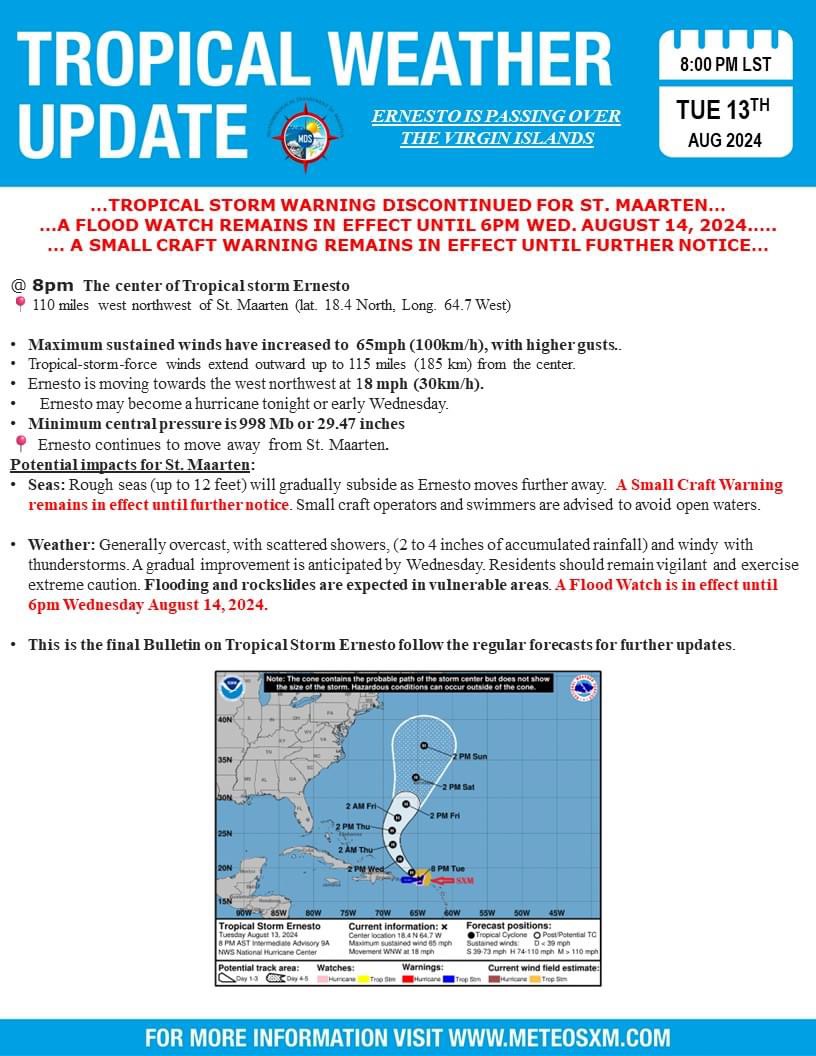
- Update
|
- By Barbara Cannegieter <barcann at hotmail.com>
- Date: Wed, 14 Aug 2024 00:23:24 +0000
|
|
|
|
- TS Ernesto - video link of ship in Great Bay
|
- By Jesús L.A. Richardson <jesusinsxm at hotmail.com>
- Date: Tue, 13 Aug 2024 19:22:25 +0000
|
|
See below link to video of a ship (that seems to be in distress) in Great Bay. I hope that they will be alright.
Winds are now coming out of the south.
Cheers
|
|
- Ready for Ernesto - 10:30am clip of Great Bay
|
- By Jesús L.A. Richardson <jesusinsxm at hotmail.com>
- Date: Tue, 13 Aug 2024 15:29:12 +0000
|
|
Other than the few essential businesses, the island is effectively closed. Philipsburg is ready. Saw a few persons on the
Great Bay beachside. Passed a handful of cars on the road.
Spent two hours at Divi Little Bay resort earlier. The sea conditions have worsened, as is to be expected.
Time to prepare lunch before the power is shut off again. #loadsheddingchronicles
|
|
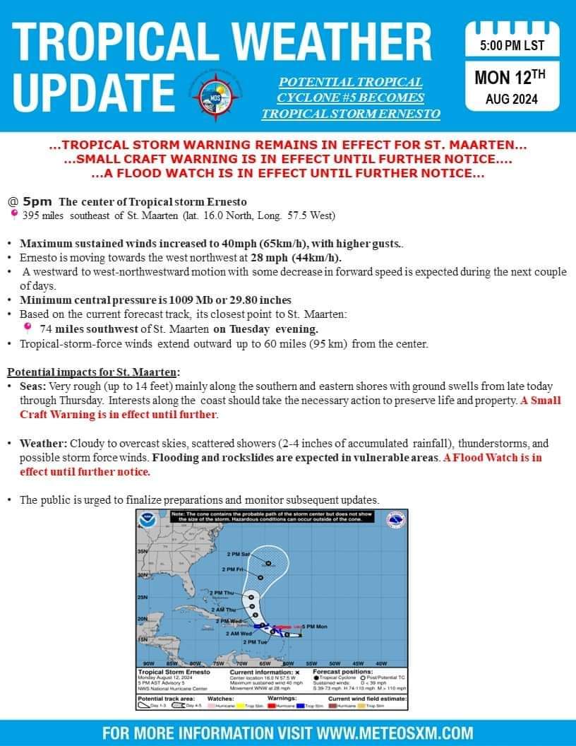
- St Maarten Met Office update on Ernesto
|
- By Barbara Cannegieter <barcann at hotmail.com>
- Date: Mon, 12 Aug 2024 22:20:54 +0000
|
|
|
|
- Another update
|
- By Barbara Cannegieter <barcann at hotmail.com>
- Date: Sun, 11 Aug 2024 22:32:15 +0000
|
|
|
|
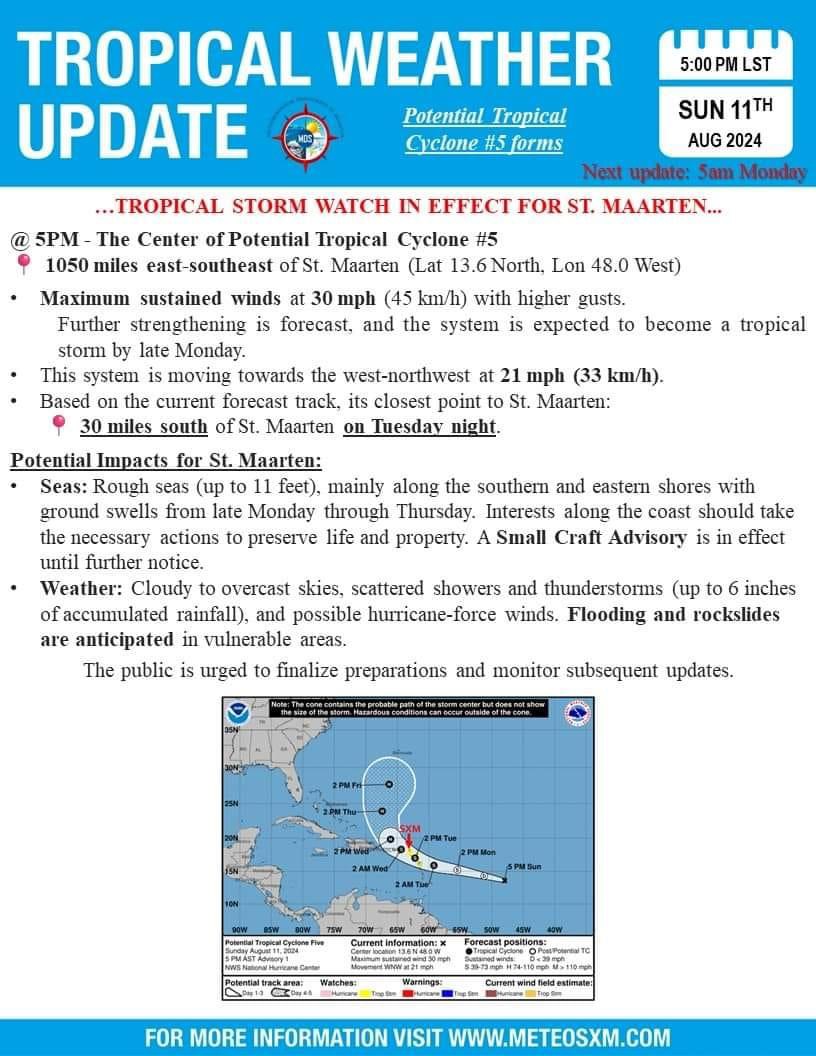
- Tropical storm watch issued
|
- By Barbara Cannegieter <barcann at hotmail.com>
- Date: Sun, 11 Aug 2024 21:27:16 +0000
|
|
|
|
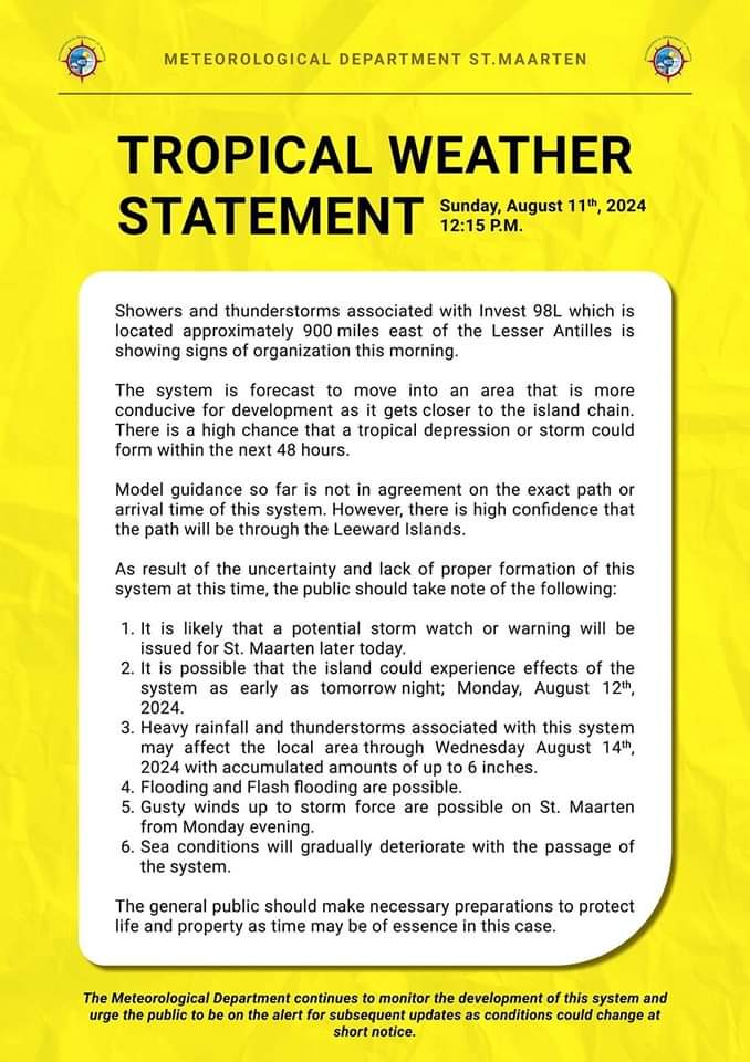
- Tropical weather statement
|
- By Barbara Cannegieter <barcann at hotmail.com>
- Date: Sun, 11 Aug 2024 19:57:24 +0000
|
|
|
|
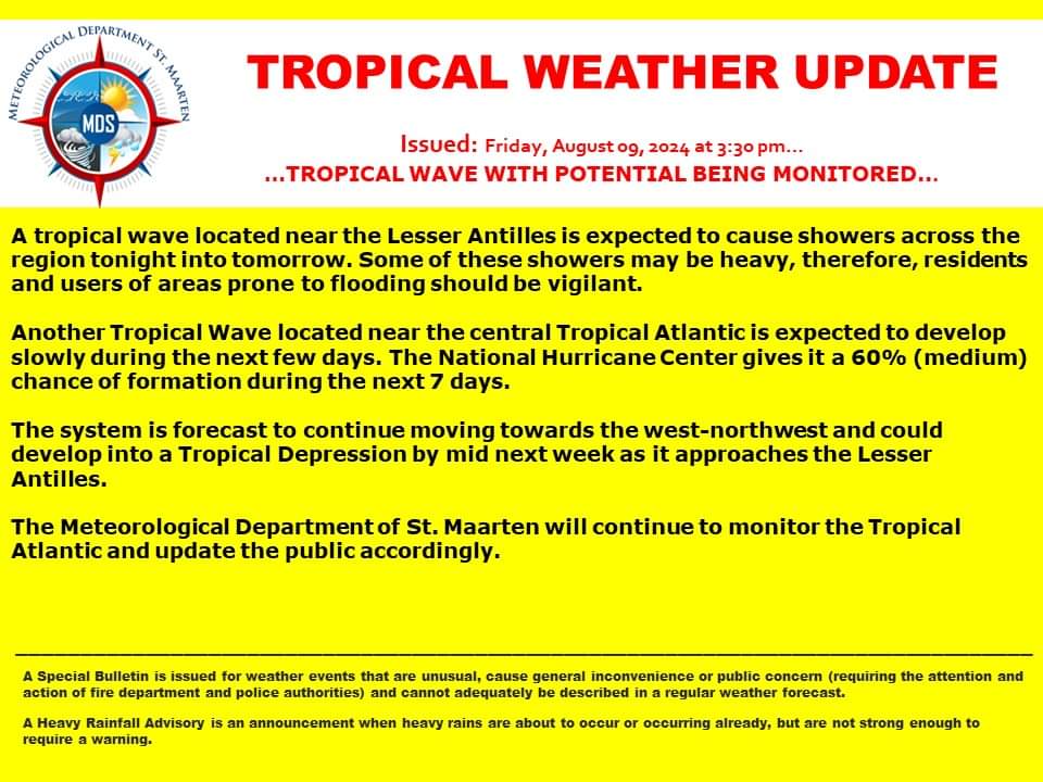
- Watching tropical waves.
|
- By Barbara Cannegieter <barcann at hotmail.com>
- Date: Fri, 9 Aug 2024 19:57:31 +0000
|
|
|
|
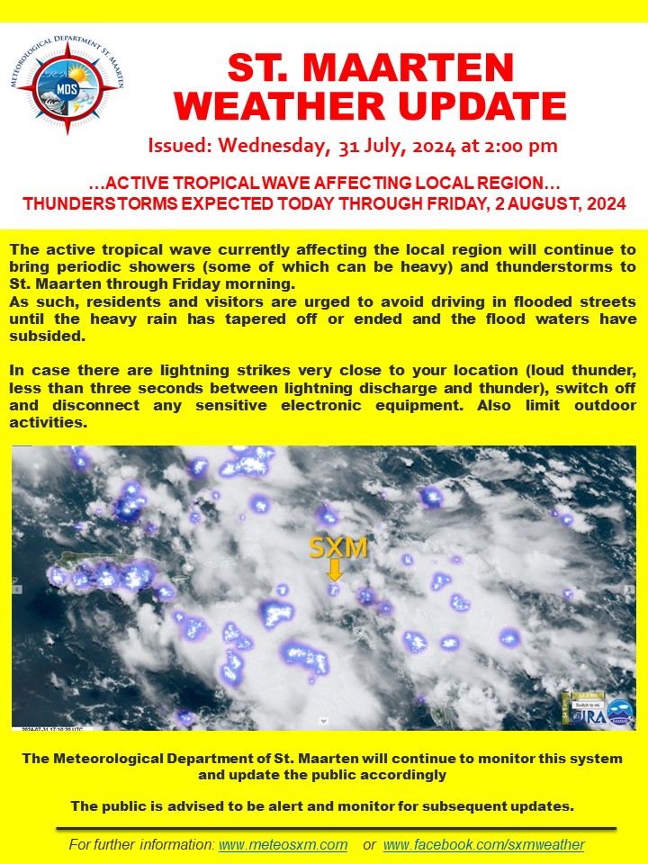
- Update . 5 struck by lightning
|
- By Barbara Cannegieter <barcann at hotmail.com>
- Date: Wed, 31 Jul 2024 20:10:58 +0000
|
|
St Maarten continues to receive rain and thunder and lightning from the tropical wave.
Sadly, the latest update is that five people were struck by lightning.
|
|
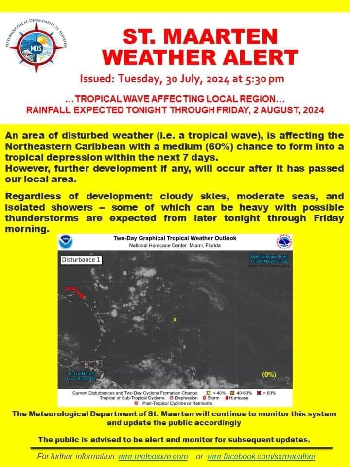
- Be careful of thunder and lightning
|
- By Barbara Cannegieter <barcann at hotmail.com>
- Date: Wed, 31 Jul 2024 18:22:35 +0000
|
This is the latest update from our Met Office regarding the tropical wave passing through.
We have not had much rain yet, but we have had heavy thunder and lightning. There was a very loud thunder clap right over us a little while ago. It scared everyone. It rocked the house.
My dogs went crazy.
It came on very suddenly. Thunder is followed by lightning. Unfortunately, two people in town on the boardwalk were hit by lightning. One lady was in a wheelchair.
I think they all are ok.
|
|
- Update
|
- By Barbara Cannegieter <barcann at hotmail.com>
- Date: Tue, 30 Jul 2024 21:59:20 +0000
|
|
|
|
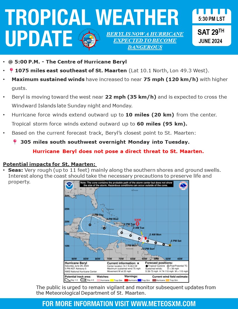
- Beryl
|
- By Barbara Cannegieter <barcann at hotmail.com>
- Date: Sat, 29 Jun 2024 23:12:09 +0000
|
Hoping the Southern islands get through Hurricane Beryl safely.
|
|
- Atmospheric river
|
- By Barbara Cannegieter <barcann at hotmail.com>
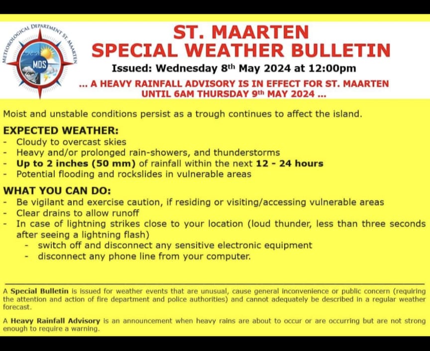
- Date: Wed, 8 May 2024 17:41:52 +0000
|
|
Good afternoon
We are experiencing the effects if what Mr. Weatherman calls an atmospheric river of moisture.
St Maarten seems to be on the edge of it. Some islands probably will have more significant flooding.
We had 3 inches of rain overnight and we are still under a heavy rainfall advisory. Currently there is light rain and thunder.
Be safe and dry, everyone.
|
|
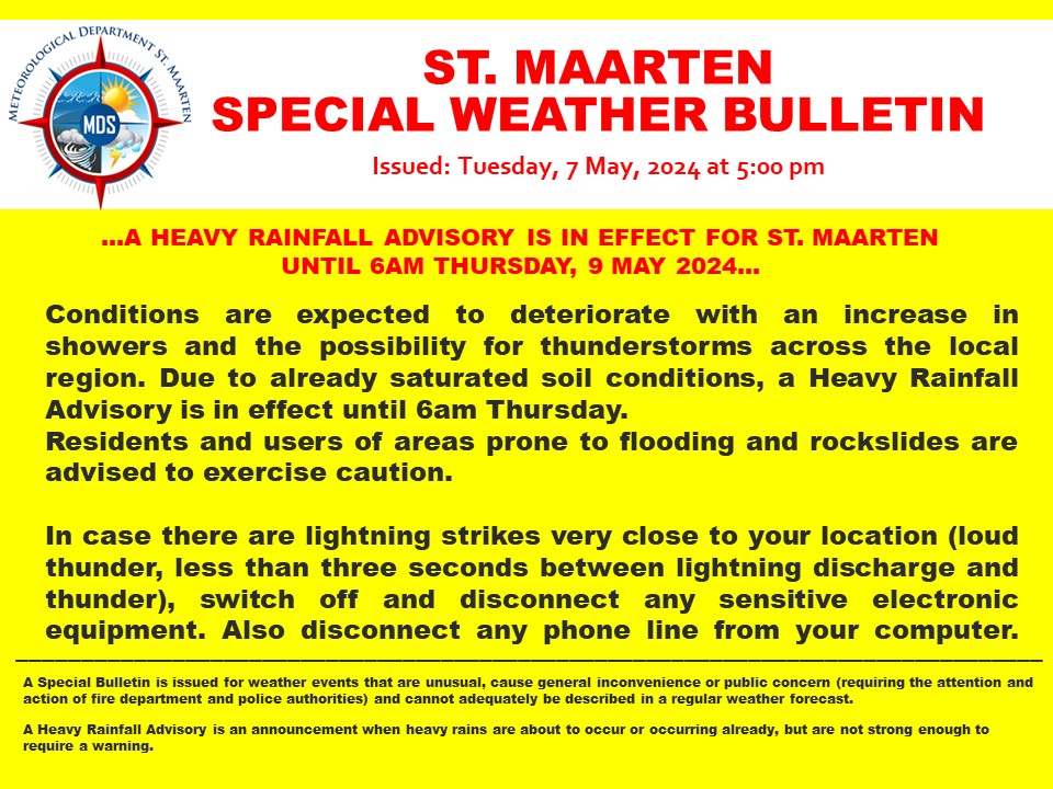
- Heavy rain expected
|
- By Barbara Cannegieter <barcann at hotmail.com>
- Date: Tue, 7 May 2024 21:24:40 +0000
|
|
|
|
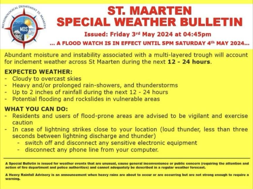
- Update
|
- By Barbara Cannegieter <barcann at hotmail.com>
- Date: Fri, 3 May 2024 21:12:50 +0000
|
|
|
|

![[click to visit gobeach.com]](/gobeachvac_skyscraper_sxm.jpg "[click to visit gobeach.com]")