|
Caribbean Hurricane Network
- 2 0 2 1 Season - |
|
|
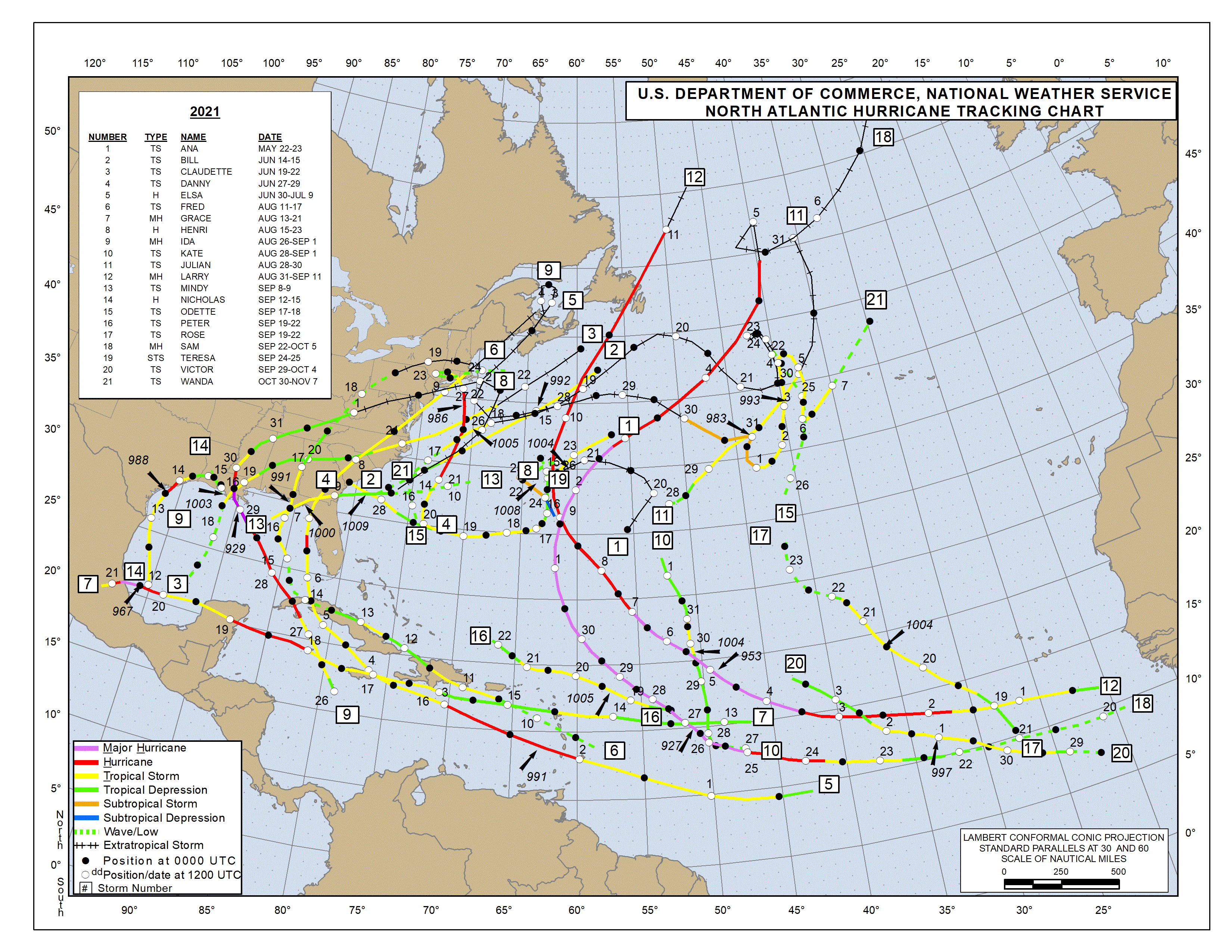
| 2021 Atlantic Hurricane Season |
| | Ana | Bill | Claudette | Danny | Elsa | Fred | Grace | Henri | Ida | Julian | Kate | Larry | Mindy | Nicholas | Odette | Peter | Rose | Sam | Teresa | Victor | Wanda | Adria | Braylen | Caridad | |
Below links to local reports from the special hurricane correspondents on the islands:
Following is an archive of all weather discussions Dave and I posted. They are in reverse chronological order, with the most recent storm discussion on top. If you want more background in formation on specific storms, I have found the 2021 Atlantic Hurricane Season section in the Wikipedia a great resource. Also, visit the National Hurricane Center's website for 'best track' data of all 2021 storms. The track map below is from that website as well.
Weather discussions by Gert & Dave during the 2021 Atlantic Hurricane Season. The homepage with the links to local reports from the islands, latest satellite image, current weather outlook can be found here.
Sunday, December 19, 2021 19:27PM EST
- End of 2021
-
Good evening all,
I hope all of you are well and safe.
The end of the 2021 year of many calamities, a few triumphs and close calls, plus crossroads is close at hand. Fortunately for most of us in and around the Caribbean, we were the lucky ones this 2021 hurricane season with relatively few impacts and contacts from the numerous systems that formed. Many were "fish" storms and the few that affected the Caribbean were a TS and three Cat 1's. Sadly a few affected the US mainland and left catastrophic damage. We did exhaust the official name list but since October and November went into early hibernation mode, we did not have to go to list #2, no longer Greek. But it was a 2 month baited breath moment waiting for the season to reinvigorate for one last lashing. A volcano in the Canary Islands that erupted towards the end of September was the wild card this year pumping more dry air and ash into the MDR that wasn't expected by any means. This just dried out the atmosphere, inhospitable to storm formation when usually, it's quite humid.
So, with that said, Merry Christmas and Happy Holidays to all. May you all be safe, joyful, helpful and thoughtful, not just this holiday season but going forward. Peace and love to all!
Dave
Wednesday, December 1, 2021 10:23AM PST - End of 2021 Season!
- Yesterday was the last day of the 2021 Atlantic Hurricane Season! Although we exhausted the 21 names on the list again this year (only third time this happened), it was relatively quiet for us in the Caribbean. We only had four storms. One tropical storm (Fred) and three Category 1 hurricanes (Elsa, Grace and Ida). Ida became a Category 4 hurricane later, close to New Orleans, and was responsible for 115 deaths and causing over 65 billion dollars in damage, all the way from Venezuela to New York! So we were lucky there!
Thanks to Dave and all my hurricane correspondents for the many updates. It is great to have such a large team of volunteers on the islands who are posting what they see around them year after year! See you all next year! -Gert
Sunday, October 31, 2021 09:02AM PDT - Wanda
- I thought the season was over... But here we have Wanda, the last name on the list. After this we will switch over to a new list of names, starting with A again for the first time. Unlike the Greek alphabeth we used earlier, these names can be retired if necessary.
Back to Wanda, this storm in the middle of the Atlantic, was a Nor'easter on the east coast of the US a few days ago. It should not be any threat to land.
Will this be the last one...? Maybe not, there is a new invest far in the Atlantic that has a 30 percent chance of becoming something. Even if, it will have turned north well before it reaches us. Happy Halloween! -Gert
Tuesday, October 12, 2021 20:38PM EDT
- October Poof (But we are lucky)
-
Good evening,
The October swoon continues as unpredicted as the activity for the month is lagging far behind what was previously forecast. This is due to a lack of instability in the Atlantic, a Saharan Dust season lasting longer than expected, volcanic ash from the La Palma volcanic eruption contributing to the excess of dry air expected, and wind shear which is stronger than projected by a long shot.
The wide mess north of the DR stretching from Puerto Rico to eastern Cuba is courtesy of an upper level low centered over Cuba and is not expected to develop due mainly to high wind shear. It did however create some moderate turbulence on my flight this morning from Miami to St. Thomas. The tail end of this trough stretches to Panama and Columbia where down the road a few models show possible development.
93L has gone Poof. At least for now. Dry air had a modest role in 93L's lack of development and timely demise but again, high wind shear basically tore it apart as it made its way towards the northern Antilles and Puerto Rico. We are lucky with this one as on it's projected path and potential development without wind shear, we probably would be staring a Cat 2 or 3 hurricane in the eye from Dominica northward to Puerto Rico. As it remains, it is still a strong system with plenty of rain, Tstorms, gusty winds and rough seas to offer the islands. I watched tstorms over the BVI's earlier with a decent amount of lightning but the bulk will come this way overnight and into tomorrow.
Off to the east a few later in the season waves are crossing the MDR with the one near 48W showing some promise but the north end of the wave is eating dust which is killing the rest of it from showing promise and the one around 27W has not caught any attention from the models or the NHC.
On a Pacific note, tropical storm Pamela definitely has not lived up to her potential which is good news for Mexico but expected to create flooding problems in Texas after landfall, maybe as a hurricane tomorrow morning. Once again, dry air ingestion was her main demise as she had everything else going for her.
Stay safe, vigilant and prepared. We still have a ways to go.
Dave
Monday, October 11, 2021 16:27PM PDT - Two waves
- Currently we have two invests, both having a slim chance to develop into something. However, both can still produce bad weather for us. The closest one is currently over the Dominican Republic and Haiti and will cause some locally heavy rainfall in the area. It is moving to the north, toward the Turks & Caicos. The second one is about 200 miles to the east of us and also cause some gusty weather over the Lesser Antilles over the next day or so. The wave is spreading over a pretty large area, so gusty conditions and rainfall will be widespread. There are two more waves further out in the Atlantic. The one closest to us (half way) is not expected to become anything, and the other one just rolled off Africa. We'll see what happens with that one... -Gert
Tuesday, October 5, 2021 18:04PM EDT
- Calm before......?
-
Good afternoon,
After an interesting September watching long lived, slo-mo major hurricane Sam who gave the Caribbean a scare, the US East coast a blink of the eye, and Bermuda the brush off, the tropics have "chilled out" for the moment. Hey, for 7 and 3/4 days Sam loitered over the Atlantic Basin just biding his time as a major hurricane, but all dressed up and nowhere to deviate and destroy, he will be remembered only in the annals of meteorological data, video and pictures as that small, fierce hurricane that captured the attention of most who he should have while not doing the damage and destruction he could have if trolling 9 mph over land.
The remnants of 91L still slowly move west through the central Atlantic and should bring some needed rains to the Windward Islands having avoided short lived TS Victor's tentacles, whose demise was accurately forecast even if his eventual strength was not. Saharan Dust is usually not this prevalent this late in the hurricane season but a look at the dust map says otherwise. Down the road, these remnants might get their mojo going in the central Caribbean where conditions will be like ripe mangoes. Time as usual will tell. Wind shear will have a say though.
The disturbance around the eastern Bahamas doesn't have much time nor favorable conditions but will bring squally weather to the Carolinas, the rest of the Bahamas, T&C plus rip currents and surf. King Tides are ready for Oct 6th and this disturbance will surely enhance their effects along the low lying areas of the coast including flood prone areas along the Carolina coast like Charleston.
The calm before the storm maybe. We still have 2 months of official hurricane season left. October has been a notorious month previously and could be this year as well. Most indicators favor an active mid October.
Stay safe, vigilant and prepared!
Dave.
Wednesday, September 29, 2021 13:50PM PDT - Victor
- Just back from a family trip/vacation in Europe and back to business! Invest 90L in the far eastern Atlantic has been upgraded to Tropical Storm Victor. It is already moving to the west-northwest so it is unlikely that it will ever reach the islands.
Meanwhile Category 4 Hurricane Sam is still plodding along just to the northeast of us. As of now Sam is expected to curve about 220 miles to the east of Bermuda on Saturday. We still have to keep a close eye on it because you don't want to take chances with a Category 4 storm. Regardless, Bermuda (and the Bahamas and East Coast of the US) will get some nice (= dangerous) swell from this system.
Invest 91L, closer to us, might still pose a potential threat. . But at the moment it is still just an Invest and nothing more. The National Hurricane Center gives it a low (30%) chance of developing into something over the next 5 days.
So still busy busy while we are almost in October... -Gert
Tuesday, September 28, 2021 07:43AM EDT
- Fortunate
-
Good morning,
Over the weekend, up again, down again Sam underwent several EWRC (eye wall replacement cycles) which temporarily dropped his strength like a gut punch but he has recovered each time and while not at 145 mph anymore, he is still a small but formidable Category 4 low end hurricane.
Prowling the Atlantic a mere approx. 600 miles to the east of the northern Leeward Islands of the NE Caribbean, Sam is crawling along a mere 9 mph while heading to the NW which is a fortunate direction for the Caribbean. It's still too early to tell with great confidence if the east coast and Bermuda will be as fortunate but from the forecast models perspective, it looks like Sam will pass them by as well although Bermuda will get a closer encounter with Sam than they want in about 4 days. Alot can happen in those 4 days though.
SW and SE of the Cabo Verde Island we have 2 systems, 91L and 90L respectively. Both low riding Invests are forecast to develop with 90L, for now, expected to trek NW while 91L to trek WNW but get closer to the islands. The same ripe conditions lie ahead of 91L although due to upwelling fro Sam, the SST's will be a bit cooler thereby putting a damper on rapid strengthening for the time being. If it does make it to the Caribbean as some models show, 91L could pose a problem in the Central Caribbean to Jamaica, the Caymans and maybe the Gulf.
The remnants of Peter off to the east of Bermuda is still trying to pull his Phoenix card but his time to get it out of his pocket and flash it is running out. It's time for Peter to be relegated. With that said, Victor and Wanda are the only 2 names left on the official list before we go to the second string. I expect these names to be used in short fashion.
Stay safe, vigilant and prepared. We have a few months to go!
Dave.
Saturday, September 25, 2021 08:42AM EDT
- Sam is an I Am
-
Good morning,
Talk of the Atlantic and Eastern Caribbean this morning is focused on what is almost and soon to be major Hurricane Sam, currently churning approx. 12.9N, 47.0 W on a still slightly WNW course at 13 mph, all satellite derived. Location puts Sam about 840 miles virtually due east of Barbados. A compact hurricane with a small "kraken" like eye, hurricane force winds extending out about 15 miles diameter wise, and tropical storm force winds out to 60 miles, Sam is expected to slow down even more and make that NW turn before it reaches our Caribbean hurricane threshold of 50W. Our threshold here in the USVI is 15.5N, 55W before turning NW to N.
In the near term, all Windward and Leeward eastern islands should be vigilant as Sam has not made that turn yet. Still too early with any certainty to tell what Sam is going to do and how that will affect the islands. The current models, the reliable ones anyway, say from the dynamics right now, Sam will pass comfortably north of the northernmost islands about 300 miles. There are many outliers though and even one of those is sometimes right. So, preparation and vigilance is necessary in case Sam decides to buck the forecast trend. We will know more precise and needed details once reconnaissance of the aircraft type reconnoiter Sam and that will happen soon. Upper level flights should take place later today and the hurricane hunters are expected to fly out tomorrow when Sam crosses 55W, the limit of their range to get to, sample Sam and get back to St. Croix safely.
With limited wind shear values, toasty SST's, and dry saharan dust/air far away to the east and north, Sam is expected to continue to be a major hurricane for the next week although towards the end of the week, he is expected to lose a bit of steam to higher wind shear and drier air intrusion. However, longer term forecasts show a couple interesting scenarios once north of the islands. One has Sam menacing Bermuda on a recurve. Another has Sam exploiting a weakness and a cut off low in the jet stream and head into the Mid Atlantic. The other shows Sam visiting Boston and points north in about 8-10 days. Ridges, jet streams, cut off lows, heck even a typhoon in the Pacific named Mindulle will have a say in where Sam eventually goes.
I doubt Sam will remain the little compact hurricane he is now as small storms tend to fluctuate dramatically in size and strength. I expect his windfield to increase, especially with the eyewall replacement cycles that are almost certain to occur. Sam is dangerous and potentially destructive and deadly. The Caribbean is not out of the woods by no means here so always prepare for the worst and hope for the best. Hopefully his breakfast of Green Eggs and Ham is in the Central Atlantic.
Meanwhile, in other places, the next wave coming off the coast of Africa might be a player downstream as the son of Sam since Theresa has already been designated as a subtropical storm of short livings. Theresa is not a big threat and will die north of Bermuda but could send some weather to Newfoundland. Without satellites, Theresa might not have even been given a name. The remnants of TS Peter are trying to play the phoenix card as well but have limited opportunity to do so and should be no threat to land masses if it does indeed pull it off.
Looking way ahead, models still persist in a homegrown threat in the Gulf affecting Florida. This is where we look for development at this time of year so it's not unusual and something to be mindful of.
Have a good, safe weekend. Stay safe, vigilant and prepared!
Thursday, September 23, 2021 07:50AM EDT
- Sam I am soon
-
Good morning,
While former storms Peter and Rose ride off into the sunset and Odette tries to make a late but sure to be short lived comeback, the invest formerly known as 98L is now TD#18 who is about to make a grand entrance as Hurricane Sam shortly.
TD#18 is projected to reach tropical storm status today and by the time this last weekend of September is over become a hurricane with a big M for major in it's sights. And not just as a Cat 3. Slow, steady strengthening is forecast with all the odds stacked in favor of this system; low wind shear, minimal dry air and dust, and very warm SST's lie in it's path. Rapid intensification is also a possibility after it strides past 50W. In other words, no good reason exists for this to not become a major, powerful, and potentially destructive hurricane.
Where it is forecast to go is not so much cut in stone which is the worrisome aspect of soon to be Sam. A major hurricane running amok in the open Atlantic is a meteorological beauty while a major hurricane impacting inhabited land masses like our islands is a meteorological nightmare. One we have all been through before and wish never to happen again.
At this moment, future Sam is expected to pass to the north of the most NE Caribbean Islands by an uncomfortable margin, sparing them of the most destructive elements while throwing some tropical storm force effects their way. This is due to the strong ridge to the north moving east and creating a weakness which the system should exploit and move more WNW than it's current path of almost due west. That's if the ridge does as forecast when it is forecast to. If it does, and future Sam lives up to his billing in strength, then he will recurve far enough to the north to spare the islands his destructive wrath. If he does not live up to his billing in strength, stays relatively weak and the ridge does not move as anticipated, Sam will be sadly enjoying a Caribbean vacation somewhere around Monday into Tuesday next week. Stronger the system, better chances for the Caribbean to be spared. I did say chances, not a certainty.
This post is not the usual, more definitive one as there is still much to learn about the intended path, power and possibilities af soon to be Sam I am. This is what we know now and we all know Mother Nature can flex her muscles at any time not to mention change her mind. Let's hope Sam I am finds his Green Eggs and Ham as a fish storm.
Stay safe, prepared and vigilant!
Dave.
Monday, September 20, 2021 18:29PM EDT
- 4 names left in the draft
-
Good afternoon,
Still 10 days left in the month of September, notorious for peak hurricane season but this peak has passed with the latter half of the month showing copious activity, names and potential; fortunately none of it realized as of yet. Four years ago however, evil twin hurricanes Irma and Maria left a destructive, devastating and deadly legacy in this same month throughout the NE Caribbean. I was on St. Thomas for them both. Maria came more of the tradtional way while Irma pulled a WSW trick, dipping due to a stronger than forecast ridge to the north. Irma tried to destroy everyone and everything. Maria tried to destroy and drown. See the pictures from our correspondent in Puerto Rico of some of Maria's impacts posted to the right of this screen. Power out for a few days and some squawk? Try 95 days for me. 4 more than Hurricane Marilyn back in 1995. That still pales in comparison to many in Puerto Rico who went 6-9 months without it. Preparation is the key but the affects and aftermath can be extremely daunting, no matter how much you prepare. Still, the ramifications of unpreparedness can be much worse including your eternal rest.
TS Peter is the closest to the Caribbean but the previously forecast hostile wind shear is continuing to inflict severe damage on his lifetime. But he's resilient in his efforts to continue his longevity. No watches or warnings have or will be issued for the NE Islands however Bermuda might be in the path of this refusing to go away storm. We shall soon see if Peter "peters out" or pulls his man card. Still squally weather will hang around as long as he's close by and he is a fighter.
TS Rose will soon lose her flowery characteristics and be relegated to degeneration in a few days as a true fish storm heading WNW then NW then North and curving east as a remnant low over the far eastern Atlantic. Her demise will be dry air intrusion and wind shear interaction. This is the first time Rose has been used in the name system but will surely be rotated in again as she did nothing legendarily catastrophic which is a very good thing.
98L could have implications down the road but where, it's too early to tell. Again, forecast to recurve towards the NW in about 3-4 days, this should be Sam soon and quite probably a hurricane towards the end of the next 5 days. Right now, pretty impressive on satellite imagery, the quicker he forms, the quicker the recurve could occur. Recurvature is not written in stone though so until it gets above 19N, then we in the Caribbean will be vigilant. Longer term, Sam might have something to say to the east coast though. Time will tell as always!
Meanwhile, the former storm artist known as TS Odette has a small chance at doing her best Phoenix interpretation southeast of Newfoundland but will have no effects on the Caribbean or the US. Her resurrection, if it occurs, will be short lived. Again, resilient.
Long term models have activity stirring up the Gulf which would be normal for the slow wind down of hurricane season but we have all seen some pretty devastating home brewed October storms and hope they are incorrect. The Gulf coast has seen more than their fair share this season.
Stay safe, vigiland and prepared!
Dave.
Friday, September 17, 2021 14:38PM EDT
- Double trouble?
-
Good afternoon,
96L and 95L both are lingering around just waiting for their chance to get named and it still looks like they will be in the coming days after playing with everyones mind on when and how strong when the potential has been there all along making for some nervousness along the east coast and the NE Caribbean.
96L will affect the Caribbean the least while running out of time along the east coast NE of the Outer Banks. Potential still to be named but short lived with that moniker as cooler waters and increased wind shear will end that run. Still, it will menace Newfoundland like it's predecessor except not as harshly, and then possibly pull a Nicholas and lose his friendship with the steering currents thus left languishing south of Newfoundland with no particular place to go.
95L, on the other hand, does have the attention of the Caribbean, the east coast, and if it remains weak enough, the Gulf of Mexico. Trying to get it's act together even though it's had a pretty favorable environment to do so already and hasn't, 95L looks a bit better today via satellite and could still reach TD status shortly. It seems to be trying to close off a low level circulation near 14N 44W as of this looking at the satellite images. If it expects to get a name and strengthen, it better soon as an ambush of an upper level area or trough of low pressure aka TUTT is waiting for it and is expected by many to destroy it's hopes with dry air intrusion and shear. This means squally weather instead of TS force weather Monday-Tuesday for the NE Caribbean. Weaker though could spell interesting and disturbing prospects down the road for Florida and quite possible the GOMEX. Stronger, if it pushes through the TUTT would have alternative but huge implications. The first hurricane hunter mission is scheduled tentatively, if necessary, for Sunday when it gets within range.
The wave that just popped off the African coast is pegged at 20% for now with a move expected towards the NW but we've seen that before. Hopefully, this one goes where it's supposed too.
Happy Friday and stay safe, prepared and ever vigilant!
Dave.
Wednesday, September 15, 2021 05:44AM EDT
- Quick update
-
Good morning all,
While TD Nicholas is expected to die out, in name only, between tonight and tomorrow, while continuing to deluge the south Gulf coast, the Caribbean has its eyes and an eerie feeling focused on 96L to the north of the DR and 95L, a lowrider southwest of the Cabo Verde Islands.
96L is still a discombobulated mess currently trying it's best to organize into something so it can menace the east coast but is having a rough go of it as it moves slowly towards the NW from the northern central Bahamas. Forecast at this moment to reach TS status and not much else, 96L will still require the east coast to pay attention, especially if the majority of the models are wrong and it doesn't get swept up out to sea.
95L, on the other hand, has already started to draw comparisons to some retired names in past devastating periods in hurricane history such as Hugo and one that hasn't been retired, Isaac. This lowrider is far enough south to avoid ingesting dry Saharan dust while taking advantage of moderate wind shear and good moisture levels in the atmosphere. On it's trek towards the Caribbean and ultimately the east coast, it will have to deal with increased wind shear from an upper level low around the northern islands which would have a detrimental effect on it's development or at least stall that development. 96L will also have a lot to say about what 95L becomes and where it will go. Originally, 95L was supposed to be a fish storm heading WNW out to sea but that's probably not happening now.
95L is either going to be hampered and taken down as that upper level low and associated wind shear protects us or, if it misses this feature, will be a major problem down the road for someone. Who that someone is is too early to accurately forecast right now but all the eastern and northern islands need to be very vigilant for a possible unwelcome visitor next week.
The wave behind it on the African coast is also forecast to develop but as a fish storm too. Thats the now forecast.
Stay safe, prepared and vigilant. Odette, Peter and Rose are soon to enter the hurricane dance.
Dave.
Sunday, September 12, 2021 10:17AM EDT
- Nicholas, Odette, next weekend Peter?
-
Good Sunday morning,
As if on cue, the tropics are flamboyantly busy with circles, X's and a former powerful hurricane turned pre winter blizzard maker. Stretching from possibly Portugal west to Greenland and south all the way to the Bay of Campeche, we have tropical possibilities and/or endings. Let's get started.
First and last on the list is Larry, once a flirting with Cat 5 status hurricane, now a prolific snow monster projected to stall and dump up to 4 feet of snow on Greenland. Officially not relegated to a fish storm due to it's Cat 1 strike on Newfoundland, Larry will no doubt be considered a lucky miss by every landmass from the Caribbean, the east coast of the US and Bermuda who endured a close encounter.
94L, currently percolating in the SW corner of the Gulf of Mexico is being investigated by the first of three hurricane hunter flights scheduled in the next 24 hours. So far, it looks to be upgraded to TD, possibly TS status shortly and when named, will be Nicholas. Most models project a skirting of the Mexican coast then landfalling on Texas at some point from Brownsville north to Houston. Since no definitive COC has been identified as of yet, as the circulation has not been closed, the landfall point is TBD. Nevertheless, heavy, flooding and unwanted rainfall will be Nicholas's future legacy over land already saturated and easily flooded including into Louisiana again. I still think future Nicholas will reach hurricane status before landfall, especially if it stays over water a bit longer where a Houston to Lake Charles landfall is unfortunately possible.
A quick peak at the NE Atlantic shows another X, possibly stewing into a named status ENE of the Azores Islands in a few days which is forecast to dip south to southeast into more conducive waters and head towards Portugal which has issued an orange warning for strong winds and potential flash flooding just a short time ago. Good to be proactive not reactive.
Back to our arena of the tropics, we have a large upper level low (ULL) north of Puerto Rico which has been spinning around the last few days but today being recognized by the NHC. Sure it was noticed earlier on satellite but now being taken seriously as an area of interest. Forecast at the moment to move towards the east coast after skirting the Bahamas, possible future 95L is not expected to become a hurricane. We have a few days to watch this slow mover but as we all know, you never know exactly how it will turn out or where it will finally land if at all.
Way east close to and south of the Cabo Verde Islands we are looking at another trio, 2 over water a few hundred miles from each other north to south and another still on land with evil intentions. Once considered to be another fish storm, 93L is now looking to move more west while it's southerly neighbor is also expected to move more west. Upper level wind shear will keep these at bay for now plus their close proximity to each other. By the end of the week though, we might have a significant system too close for comfort to the northern islands and it doesn't matter which one as it only takes one which I've shared for years. Time as always will tell all.
Stay safe, prepared and vigilant!
Dave.
Thursday, September 9, 2021 21:09PM EDT
- Quiet though circles abound
-
Good night,
I hope all is well and safe at this time. It's now entering the climatological and historical peak week of the Atlantic hurricane season with "only" 82 days left until the official end. The way things are going so far, it's gonna be a long 82 days and probably then some. Let tonight's circles on the map begin.
Hurricane live a long time Larry is still churning 190 miles northeast of Bermuda where tropical storm warnings were up but have been dropped just recently as he starts moving more northerly while planning on a date with eastern and southern Newfoundland; St. Johns in particular. Larry could easily still be a Cat 1 post tropical storm at that time but forecasts show a bit weaker system however, first impacts should be of hurricane strength. Nevertheless, they are in for a rough time as Larry will show no mercy on his way to his demise, in an area not known for numerous tropical activity. Hopefully, he swings south on his pass by. Not likely.
TS Mindy is now TD Mindy with her short life as a name about to be ended either overnight tonight or tomorrow due to her forward speed and increased wind shear, already taking their toll. Landfalling SW of Apalachicola around 8 pm last night, she quickly dropped heavy rains on the Florida panhandle, Georgia and SC before exiting into the Atlantic and ending her short lived hit and run. It's possible many didn't even know of her existence. She was that quick.
Back to the SW Caribbean and the Bay of Campeche where Mindy was hatched, another system is projected to blossom into a short lived, heavy rainmaker depending highly on track and upper level shear and steering currents. If it stays off land then the potential is high and if it plows into Mexico then potential vanishes. Right now though the forecast is to stay off land and bring heavy rains to parts of Mexico, the gulf coast of Texas and into Louisiana, Not a good setup for that area at all.
Off to the east, it's pretty quiet for this time of year with the wave train continuing but fortunately not reaching its potential. The next wave though to splashdown is expected to reach some of its potential and then the race is on to see who reaches Nicholas first; this one or the SW Caribbean system, neither dubbed an Invest yet. Forecast for this one is a direct WNW to NW flyover of the Cabo Verde Islands developing quickly on it's way.
So, 61% of the hurricane season remains. That's a lot with only 82 official days left. Nuff said.
Stay safe, prepared and vigilant!
Dave
Sunday, September 5, 2021 09:11AM EDT
- Larry the Scary
-
Good morning,
In Trinidad and Tobago, the damage created by the wave that was out in front of Larry, while undeveloped, is substantial as Gert and Jane Higgins have shared and a warning to all who underestimate the weather as Michael shared from Dominica as well. It also underscores the need for proper preparation and vigilance.
Major hurricane Larry is scary and beautiful at the same time on satellite this morning as he prowls the open Atlantic. Presenting an almost perfect round donut or truck tire appearance with a large eye at over 40nm wide, Larry should be considered an annular hurricane which is more prolific in the Pacific and rare in the Atlantic. These types of storms weaken slower than classic hurricanes and maintain peak intensities for much longer usually. In Larry's case, he is expected to maintain Cat 3 major status until his close-by date with Bermuda in 4 days while flirting with Cat 4 periodically throughout. His threat to land appears to be aimed only at Bermuda for now while large swells and rip currents will affect the Caribbean and the east coast, dangerously so.
91L is quite the mess over the Yucatan with heavy rains continuing to fall as the models still disagree on development in the Bay of Campeche and/or the Gulf which no one wants to see. If it does try to develop, strong wind shear will be it's greatest wished for detriment while paralleling the gulf coast to Florida. Other paths considered would be the Mexican coast but also north to Texas and La. Regardless of what 91L turns into, if anything, heavy rains will be it's primary threat wherever it goes.
Off the coast of Africa, the wave train continues while a large and dense plume of Saharan Dust plunges southward temporarily inhibiting any development right off splashdown. Operative word being temporary. With the ridge to the north weak in some spots, what does form probably would go out to sea as another fish storm but too early to tell obviously. They will go where they want to and that's what we do know for certain. Also, home grown storms like 91L has potential to be, are always a threat anytime.
Stay safe, prepared and vigilant.
Saturday, September 4, 2021 20:54PM PDT - Larry
- Hurricane Larry is now a Category 3 hurricane. I would love to say that it is just a fish storm but it is getting a bit too close to Bermuda for comfort. On the other hand, the different models are in pretty close agreement that it will pass Bermuda well on the east. The official forecast has the closest point of approach with Bermuda about 215 miles (Thursday afternoon). Earlier forecasts called for a Category 4 hurricane, but now it looks like Larry will 'just' stay a Category 3. And that is kind of the main reason why we should keep a close eye on Larry, it is hard to relax when a major hurricane seems to come for you... The Caribbean islands will be ok, apart from some possible swell.
On another note, a tropical wave that went over Trinidad and Tobago actually resulted in quite a lot of damage; hundreds of roofs damaged, plenty of fallen trees, etc. See for example this Trinidad Sunday Express article (forwarded to me by Jane Higgins from St.Thomas). Micheal reporting from Dominica put it well: "This undoubtedly underscores the need to remain prepared through the entirety of the hurricane season & why there is truly No such thing as 'Just' a Tropical wave or Tropical depression, or 'Just' a Tropical storm or a Category one or two hurricane...". Times are a-changin... We have known that we were messing with climate for a long time. With Ida in the US, causing major flooding in New Jersey and New York, a long way away from Louisiana where it made landfall. '500 year floods' or whatever. We all know what is going on, I wish we ('governments') would actually do something for real about it, it is time for some big action, not just small 'initiatives'... -Gert
Thursday, September 2, 2021 09:29AM EDT
- No September slumber
-
Good day all,
First a hearty congratulations to Isabel, our long time contributor and her husband from St. Croix USVI on their 58th wedding anniversary yesterday! Hope you have 58 more!
From Jamaica, Cuba and the Caymans, through Louisiana, Mississippi, and up through the northeast, the beastess known as Ida has formally ushered in September on the way to her final demise in the north Atlantic but not without leaving death and billions of dollars of destruction in her wake. With the female named storms doing the most damage this hurricane season so far, it will be no surprise that the name Ida will almost assuredly be retired from ever terrorizing again. The NHC and the NWS did an excellent job forecasting not only her track from beginning to end but also her unfortunate and deadly consequences. Those who didn't heed the warnings have no one to blame but themselves for lack of preparation and in some cases, evacuation. These storms and situations are not a game of Chicken Little. They are real.
While Ida was finishing her domination last night and today, the rest of the tropics have been largely ignored. Well, they now want recognition and it's not the kind anyone wants to see anytime, especially in September; a major hurricane soon running amok in the Atlantic.
Meet Hurricane Larry. Rapidly transitioning off the African coast, Larry has rapidly intensified into a hurricane as of early this morning and is poised to make another run at rapid intensification to major status by Saturday as conditions are quite conducive. At approx. 13N, 33W and currently trucking along at 20 mph to the west, Larry is forecast, at this time I stress, to become a fish storm with potential to affect Bermuda directly down the road in a week's time. Lots can happen in the meantime as we all can attest to though. Larry's projected path keeps inching to the west and in some models to the WSW, as the steering ridge to the north strengthens and what was once TS Kate's inducing weakness in the ridge closes up. Again, at this moment, forecast to miss the Caribbean and the east coast only throwing large sea swells our way but if that steering ridge shows no weakness and is stronger than the models project, there could be trouble in paradise. Just covering the possibilities. I remember Irma's path all too well.
Out in front of Larry, an interesting tropical wave is along 52 W but has no interest at this time from the NHC. Moving to the west at a rather quick 23 mph, it is not forecast to develop anytime soon but as with all waves, it needs to be monitored. Upper level winds are not too friendly which is why not much attention is being paid to it but that should change over the next few days.
91L is trying to get it's act together off the coast of Honduras and will bring heavy rains to the Yucatan and central America. It's window of opportunity is short but if it does take advantage after moving over the Yucatan into the SW Gulf, things could get interesting along the gulf coast again. Potential yes. Probability not much but something to monitor regardless.
Other areas of interest include off the coast of Florida and the Bahamas. Waiting in the wings are several impressive waves getting ready to make their splashdown off the coast of Africa. The CV season is in full swing as promised. Sadly, these next four waves look too promising which includes the wave right behind Larry. Time as always will tell and we all have time right now to finish any preparations you haven't already. The MDR bowling alley is open for business.
Stay safe, prepared and vigilant!
Monday, August 30, 2021 18:26PM EDT
- Cat 4 smackdown plus
-
Good afternoon,
There is not much for me to comment on with regards to Category 4 Hurricane Ida that hasn't already been covered or stated. I will say the NHC did a heckuva job as did many of the computer models they rely on with the forecast of track and intensity level. They take a lot of heat most of the time and deserve kudos. There are some people who refused to mandatorily evacuate though now asking for help when they should have left. I understand a few cannot leave for fear of losing their jobs by not reporting right after the storm likes nurses. Some couldn't leave because of the short notice Ida gave to evacuate. Some just cannot afford it or have nowhere to go although there are shelters. But some just stayed. That's their prerogative. Maybe the lessons from Katrina 16 years ago to the day weren't learned. Hey, we are still a free country. I just hope their unnecessary (if they had evacuated in the first place) rescue doesn't cost any additional lives. Property can be replaced. In Ida's case, that will take quite a while along with the power grid restoration. She should be included in the "I" name list of infamy, retired forever more. The death toll will surely rise from 1 as many areas have not even been reached yet due to high waters, impassable roads, and major debris. This will sadly add to her infamy. Prayers and condolences.
While Ida was on her rant, very few noticed short lived TS Julian. Born and dead within 24 hours, the former known as TD#11 put on a quick show of strength before collapsing just as quickly, relegated to a small footnote in history by happening at the same time as Ida.
TS Kate, the former TD#10, was declared today looking to have a much longer shelf life than Julian. Kate is fighting vicious wind shear and a dearth of humidity at the middle levels. However, if she is able to maintain her tropical dignity, Kate has an outside chance at attaining hurricane status. Whatever she morphs into, Kate will likely move NW and eventually N, no threat to the Caribbean or the US.
Off the African coast we have newly designated 90L which already is expected to attain possible hurricane status by the end of this weekend. At this time, it is expected to become a fish storm and curve out to sea; no threat to the Caribbean and the US. It might even become a major so it definitely can stay fishy.
In the SW Caribbean, another possible system is expected to form, if it manages to stay over water. Expected to stay close to the Central American coastline though, it might not. Close attention needs to be paid with this one as if it doesn't plow into that coastline and stays over water, we might have another intensifier in the gulf.
Stay safe, prepared and vigilant.
Dave.
Friday, August 27, 2021 18:48PM EDT
- "I" for Incredibly Dangerous Ida
-
Good afternoon,
If there ever was more chances for non conformity, I'm sure 100%, we all wish that Hurricane Ida would take it, succumbing to miraculous wind shear from soon to be Hurricane Nora, who is likely to become only the 4th tropical storm to reach Arizona in recorded weather history through the Gulf of California aka the Sea of Cortes. Nora's rains will be ever so welcome for the parched west, however, we are not talking about Nora here, Ida will not succumb, and her projected rains will have a devastating impact far inland from landfall.
Earlier, Ida menaced Jamaica and the Caymans with heavy rains and gusty winds while getting herself together under the guise of discombobulation. Taking advantage of very warm waters, moist humidity levels, and moderate wind shear, she went from 20 mph to 75 mph in a New York minute. That equals RI or rapid intensification which wasn't expected until after she left Cuba and landed in the Gulf of Mexico's welcoming arms. This has made for major, dangerous implications. With RI expected again after leaving Cuba, a major hurricane will be loose in the GOM with no escape to sea and an eye on Boubon Street.
Currently, the center of Ida is to the NW of the Isle of Youth which just sustained Ida's fury as a burgeoning Cat 1. She will be over the western skinny edge of Cuba shortly which might slow her explosive growth down slightly due to land interaction, dry air off the land, and a disrupted air flow. Do not let this fool you. If anything, it won't last long. As I said, slightly. Ida's cloudtops towered 60,000 feet in the air and were seen by Key West radar, about 250 miles to the north on approach to the Isla of Youth.
The potential for Ida is a Category 5; more probable is a Cat 4. The only 2 real issue's that could stand in her way of becoming only the 5th lower 48 landfalling Category 5 hurricane who was only a seedling tropical storm 3 days previously are an unforseen increase in wind shear, or an EWRC (eye wall replacement cycle). The other 4 Cat 5's were the Labor Day hurricane, Camille, Andrew and Michael. If the EWRC does occur though, the new eye will normally be larger and the windfield will expand father out.
Ida appears well on her way to becoming a major monster eyeing Louisiana somewhere. It could still jog west or more east. The damage will be immense and sadly, the death toll will be a sombering statement of Ida's fury. While the wind will have it's day or two, water in this case will surely be the main killer from flash floods, storm surge, and a refusal to evacuate. Due to the high moisture content of the soil, the brown ocean effect might come into play and Ida will not wind down as fast as projected. Farther inland, that spells more troubles for Mississippi and Tennessee.
Off to our east, 97l and 98L are still lurking but are still forecast to become fish storms and not a threat to any landmasses except maybe the Azores. The next few waves are already primed and on their way across Africa. We all watch with almost wide eyed terror at what is going to unfold to the west while a wary eye still needs to be pointed east. Prayers to all those in the path of Ida, soon to be the next retired "I" of storms.
Stay safe and prepared!
Dave.
Thursday, August 26, 2021 09:00AM PDT - Cayman get ready for Ida
- Invest 99L was upgraded to Tropical Depression 9. It is expected to pass over Grand Cayman tomorrow AM. Tropical storm warnings have been issued for the Cayman Islands and western Cuba. It is expected to become Tropical Storm Ida when it passes Cayman. Just as Dave discussed yesterday on then 99L this could become a major threat for the Gulf Coast. Waters are plenty warm in the Gulf of Mexico and wind shear is low, so conditions are good for the storm to become a major hurricane by landfall late Sunday... For the Caymans I don't expect too much problems but people on the Gulf Coast should pay close attention. -Gert
Wednesday, August 25, 2021 16:31PM EDT
- 3 more racing to a name
-
Good afternoon,
After enduring Fred, Grace's and finally Henri's shenanigans of not following tropical system normalcy, we now have 3 Invests and a probable 4th very soon taking their place but with way different potential paths, impacts and strengths.
97L: Conditions are ripe for this system to develop over the weekend into next week after overcoming early wind shear resistance the next day or two. Forecast to turn eastward while developing into a Cat 1 or 2 hurricane, 97L, about 800 miles SE of Bermuda, is set to become a fish storm with no impacts landwise until it reaches the Azores. It's status then is uncertain as will be the effects if any.
98L: The low rider of the bunch with the least % chance of development currently posted by the NHC. Located several hundred miles to the SW of the Cabo Verde Islands, 98L is also eventually forecast to become a fish storm as it moves a modest 10-15 mph towards the west/west northwest. It is also forecast to be the weakest of the current triplets, reaching TS status with an outside chance at Cat 1 as it runs into non friendly Saharan Dust and upper level winds.
99L: This one is the big mystery which should soon manifest itself where it's going and at what strength will it arrive. Short term it takes up all of the central Caribbean with blustery conditions for Jamaica, The Caymans, parts of Cuba and the Yucatan, just visited by Grace. Long term will be less determinate and potentially frightful.
Currently there are two distinct vortices competing with each other to win the coveted title of the COC, one to the north and one to the south. Whichever one wins will go a long way towards determining what 99L morphs into, what strength it will eventually reach, and where it is headed. Usually, the north one wins. If it does, chances are Louisiana to the Panhandle of Florida will be the leaders in the sweepstakes. If the south wins, then it's more likely Texas will take over with a touch of Louisiana hanging in there. Strength wise, a hurricane is very probable from Cat 1 to, in my opinion, a Cat 3. While time in the gulf is limited either way, the waters are exceptionally warm overall with various hotter pockets and a very hot loop eddy south of La and Mississippi. This could lead to RI close to the coastline. So, for now anywhere between Galveston and Perdido Key, Florida should be keeping close tabs and preparing for a hurricane impact next Tuesday/Wednesday based on current conditions. Lake Charles cannot seem to catch a break. But it all depends where the COC forms and what Recon aka the Hurricane Hunters find. Either way, this will be a large storm taking up a large portion of the gulf affecting numerous millions.
Another impact of this system, especially for the SE, is the potential for a stalling/slow moving storm dumping more rain on an otherwise already soggy SE US and moving up through Mississippi, into Tennessee, the mid Atlantic and eventually the NE where deadly flooding has already occurred.
The race to earn the next name, Ida, then Julian, and then Kate is on. Mainly between 97L and 99L. The next several weeks we will experience every wave coming off Africa as a potential disaster in the making. I think the next one off Africa and definitely the one behind will be problematic. They might start early and they might act up closer to your doorstep. It's all about us being prepared as best as we can and being knowledgeable of your environmental surroundings near and afar.
Stay safe and prepared!
Dave
Saturday, August 21, 2021 15:01PM EDT
- The 3 nonconformists
-
Good afternoon,
Fred finally ended his nonconformist ways earlier this week in NE while hurricane Henri, the third nonconformist, is poised to make a followup visit in a much stronger capacity, forecast to make landfall tomorrow as a Cat 1 or, unsurprisingly a possible Cat 2, in the middle of Long Island. Henri will usher into NE heavy rainfall with dangerous flooding, power outages, downed trees, powerful storm surge and of course, wind damage. Lots of trees and power poles have been weakened by plenty of rain already from the summer and Freds visit. The soil is already saturated which does not bode well. Henri, will slow down on approach, wander for a short bit, then get picked up by an approaching front, rapidly ending his unwanted visit. Some are already comparing his visit to hurricane Bob's, some 30 years ago, one of the most costliest in NE history.
TS Grace, the second nonconformist, is dying out slowly over the mountainous terrain of central Mexico but not without further copious amounts of flooding rainfall still to come. There is a good chance parts of Grace will reform over the Pacific after leaving Mexico. New storm and a different name if so.
Off to the east, a significant slug of dry Saharan Dust is just to the north of the MDR and this is where a tropical wave being given only a 10% chance of developing is forecast to travel. Thus, we are not looking for this wave to develop into anything threatening down the road. Behind this one there are several more per usual and long term models are bullish on a couple already. Definitely, the wary eye needs to be warier!
Stay safe and prepared!
Dave
Tuesday, August 17, 2021 09:06AM EDT
- Go their own way
-
Good morning,
It seems like both Fred and Grace are storms that do not listen to and do what they have been forecast to do; they essentially went "their own way" from the beginning. The song by Fleetwood Mac comes to mind. This just proves that with all the power and technological advances we have at our disposal, weather is an inexact science and we have much to learn about and from it. Mother Nature is happy to teach lessons not in the lesson plan.
First, prayers for the populace of Haiti suffering immensely from the deadly earthquake, Graces not so graceful hampering of rescue and recovery efforts with her piling on copious amounts of rain, and other scary aftereffects as noted by one of our volunteer hurricane correspondents in Haiti, posted to the right of this screen.
Speaking of Grace, now back up to a TS, albeit a disjoined one as the hurricane hunter mission revealed, she is currently headed for an intimate heavy rain flooding encounter with Jamaica while still dragging her feet across Haiti, then flirting with the Cayman Islands on her way to a date with the Yucatan Peninsula of Mexico all the while scraping the southern Cuban coast. Now there's a mouthful of Caribbean geography. A very strong ridge will keep Grace on this mostly westward track while "forecasted" to stay just below hurricane strength upon her collision with the Yucatan and then again, the Mexican mainland. With the water's much warmer than necessary and wind shear in moderate doses, I think she will make it to Cat 1 at some point.
Fred, while not dead, soon will be after coming close to the minimal hurricane threshold before landfall just north of Apalachicola Florida. Heavy rains, flooding and isolated tornadoes will be his legacy as his remnants travel up the Appalachians where his rainfall is needed in some drought areas though not so much at one time. Fred's leftovers, along with the front that picks him up, will also help newcomer TS Henri, doing a ring around the rosey of Bermuda, to end his soon starting western trek and head out to those colder north Atlantic waters. Henri also has a shot to make it to short lived hurricane status but a heavy dose of wind shear will probably keep him from that goal in the end.
Off to our east, a middle MDR tropical wave shows little promise while another just off the African coast has some prominent size to it, at least initially. In order for it to have any chance of success, it needs to stay south of a deep concentration of Saharan Dust to it's north. With the strong ridging courtesy of our Bermuda high to the north, a westward trek that stays south of the dust is manageable.
Stay safe and prepared!
Dave
Sunday, August 15, 2021 08:41AM EDT
- Not so "Graceful"
-
Good morning,
First, prayers go out to those in Haiti from a non weather event, the earthquake of yesterday morning. Gert is right; Haiti never seems to catch a break and now TS Grace could hamper rescue efforts. Slight good news though. TS Grace actually did fall off one side of her chariot in the last 24 hours as, between my last post yesterday morning, she sped up to 26 mph which really hampered her strengthening capability and has kept her a minimal tropical storm as opposed to a mid grade stronger one. She has also wobbled a bit south as all storms wobble at some point, thereby sparing all the Virgin Islands the heaviest of the rainfall and sustained TS force winds. By the time I finish writing this, she will be almost due south 45 miles away from St. Croix, just outside the sustained TS force wind field. Gusts to that and over are still probable though. Luckily, most of Grace's disorganized affects and appearance is stretched out to her south over open eastern Caribbean waters.
Grace's increase in forward speed which has dampened her enthusiasm for strengthening was also a blessing for our other islands of Antigua down to Montserrat as there are minimal damage reports, especially in the flooding category which is great news. Some islands were happy to receive some more rain due to lingering drought conditions this year to date but not much else affects wise. All watches and warnings have been discontinued from the British Virgin Islands south while warnings continue for the USVI, PR, and for all the DR except the most northern coastline. So far, for the Windward and eastern Leeward Islands are concerned, Fred and Grace have been good lessons and practice for potential stronger systems later this season. Let's keep our fingers crossed these were the strongest tests we will experience this year.
Still following Fred's lead, Puerto Rico is next for Grace and some strengthening is expected now that she has slowed down and is back to moving more WNW. Rains for the southern and western coast of PR will be more prodigious while the wringer ahead that is the mountains of the Dominican Republic and Haiti await. Those same interactions with these mountains, or lack of, will dictate what kind of system survives, in what form, and where she will go. Right now, the models are all over the place in that respect but that's to be expected due to the unknown collision ramifications ahead.
Speaking of Fred, he's still a hollow shell of his former self, a remnant, after a bad date with Cuba, but is expected to restrengthen into a modest TS by the time he impacts the Florida Panhandle or Alabama's small coastline on Monday morning. With a slight wobble himself, he could even make landfall in Mississippi. Hopefully, a positive impact of Fred will be a dispersal of the red tide invasion.
Up by Bermuda is newly designated 96L which could become our next named storm, Henri, in the next 48 hours. This system could bring squally weather to Bermuda as it is forecast for now to head south then loop under Bermuda and head NW into the North Atlantic and oblivion; a menace only to shipping and the fishes.
Off to our east where Fred and Grace were spawned, the newest contender this year has fallen off the coast of Africa. As with all waves at this time of year, a wary eye needs to keep watch.
Stay safe and prepared!
Dave.
Saturday, August 14, 2021 10:23AM PDT - Earthquake in Haiti
- A quick non-hurricane update: Haiti never seems to get a break. This morning a magnitude 7.2 earthquake hit Haiti. The epicenter is located in the southwest part of the island, close to Saint-Louis du Sud, less than 100 miles from Port au Prince. The catastrophic earthquake that struck close to Port au Prince in 2010 which killed over 220,000 people was a 7.0. This area is less dense populated but houses are not really 7.2 magnitude earthquake proof. It is also hard to get aid to that region because of unsafe conditions along the major highway leading to that area... And to further complicate things Grace has the potential to dump quite some rain in that region starting late Monday, hopefully Grace stays more north and small enough to avoid the heaviest downpours... Please, consider donating to your favorite charity to help them out... -Gert
Saturday, August 14, 2021 09:17AM EDT
- Fred & Grace
-
Good morning,
Sounds like a wanna be spin off of the old series Friends with Fred and Grace however, Fred and Grace are anything but friendly in this episode with future episodes about to get worse.
TD Fred has left his extended date with Cuba which has left him a mere shell of what he used to be. Cuba's mountainous terrain has shredded this short lived (only 6 hours) tropical storm while also blocking life giving moisture from entering the circulation, thereby further inhibiting any strengthening or even maintaining. Hurricane hunters are investigating the leftovers right now and it's very possible the dismembered remains of Fred will be relegated to an open wave since it's mid level circulation appears to be south of Cuba and not over the lower level remnant circulation. Regardless, Fred is forecast to regain some semblance of a tropical storm, strengthen slowly and lumber into the Florida Panhandle or Alabama coastline on Monday after a blustery, squally weekend in the Keys. Florida itself has dodged a potential major flooding bullet. For now.
Next up in this mid August conga line is Fred's beau Grace, now a tropical storm herself with much more evil on her mind than the gentlemanly Fred. Grace started out the way Fred did and is following essentially the same path. Fred has "graced" Grace's path with way less dust to contend with while leaving a lot more moisture for her to work with in his wake. She is rapidly gobbling up this gift, moving to the west around 22 mph which is hurting but not entirely killing her chances of strengthening into a hurricane before reaching the islands which is a very good thing. There is still a bit of dust and dry air to the north for her to contend with as well, just not as much.
Grace will impact the northern Leeward Islands this weekend as a forecasted mid level tropical storm with winds 50 mph sustained gusting to 65. As she will be going over about 85 degree SST's with lower wind shear and higher humidity, I expect Grace to be a bit stronger as she goes through the islands. RI is not expected but she seems to be getting her act together quickly despite her fast forward speed. The usual suspects surrounding the impacts of a strong TS will be present with damaging gusty winds, rough seas and surf, heavy rains with flooding and landslide potential, coastal erosion especially on the beautiful southern beaches, and our usual, at any time not just during a storm, power outages.
TS warnings stretch from Montserrat northward with watches expected to be posted for the DR and Haiti westward today. Using the tools that are available above you can extrapolate out potential time of impact and distance from you as Grace or any other system approaches. Use these as guidelines only as tracks will shift, storms wobble, slow down, speed up, fall apart or strengthen. Grace is a small storm even though it doesn't look so on satellite with TS force winds extending only about 30 miles from the center. However, that is sure to increase.
Right now, Graces current track shows a very close encounter with Montserrat on Sunday morning about 6:18 am, slightly 17.5 miles to it's north as a 50mph TS. That same track shows a direct hit on St. Croix at 5 pm Sunday afternoon possibly as a stronger TS. Again, these are the now tracks, times and distances which are subject to change but they will not change much unless Grace falls off her chariot. Bottom line is Grace will not be as nice as Fred was. Fred's visit gave us a good practice run but Grace will not be there for practice or a friendly visit.
Down the road for Grace, the DR, Turks and Caicos, Bahamas and Florida again will be in the crosshairs. If she avoids the terrain of the DR and the effects of a dropping down trough, there will most likely be a hurricane on the doorstep of South Florida next week.
Stay safe islanders and finish preparations quickly if you haven't already!
Dave
Friday, August 13, 2021 15:58PM PDT - Deja Vu all over again
- When 95L passed over a Woods Hole buoy a closed circulation was found. Therefore it was upgraded to Tropical Depression 7. It is expected to become Tropical Storm Grace later today or tomorrow. The depression will follow almost the same track as Fred did a few days ago. Therefore tropical storm watches are up again for most of the northeastern islands (see the latest advisories). Tomorrow the effects will start to be felt. So far the forecast shows that it will just stay a tropical storm and that it won't strengthen into a hurricane. However, you can still expect a lot of rain and some gusty winds. Stay safe! -Gert
Thursday, August 12, 2021 15:07PM EDT
- Persistent Fred w/Grace in the wings
-
Good afternoon,
I was traveling yesterday hence no post from myself and todays is later than I wanted but work comes first.
Fred sure took his good old time becoming a named storm finally closing off that western quadrant, completing the circle and reaching named status ending several days of conjecture which left forecasters and the public hanging. Something to be said for persistency though as he has fought through dry air intrusion, wind shear, medium humidity levels, a somewhat fast forward speed, and now the mountains of Hispaniola. Behind him he leaves a legacy of not really living up to the hype of a storm after lumbering through the mid Windward Islands and waving at the Virgin Islands and PR as he passed by. Now, according to local reports, some seen here by our all volunteer contributors, Fred has made only a slight impact in the DR with the mountainous terrain having a major impact on Fred. Knocked down to a depression, Fred now has to regain his Caribbean footing or possibly fade away into an open wave. While this is possible though, it looks like Fred will not die yet.
According to the tightly clustered track guidance for the next few days, Fred will menace the Turks and Caicos, southern Bahamas, Haiti and finally South Florida in the realm of anywhere btw Miami and the western Florida Keys. That part is still not certain as Fred will make a turn to the NW around the southern edge of that sprawling Bermuda high but just exactly where is yet unknown. A quick turn means a serious drenching and flooding with limited wind impacts while a more western turn will see it possibly in the GOM. That will be interesting if that happens as if it does, I believe it will get stronger than they say it will be.
95L, out to our east, is chasing Fred's coattails, almost taking the same path as he did on his trek across the MDR. Like Fred's track, possible Grace down the road is expected to probably form into a depression or storm on approach or just after passing through the island chain. More to come on this one and the season long wave train behind it.
Stay safe and prepared!!!
Dave
Tuesday, August 10, 2021 09:40AM PDT - UN IPCC Report
- Still no Tropical Storm Fred, but it might get upgraded later today, while it is moving south of the northeastern islands, bringing squally weather, with tropical storm watches and warnings posted.
On another topic, yesterday a new climate change assessment report was released by the United Nations Intergovernmental Panel on Climate Change (IPCC). The last report was issued 2013. As if we had not known for years, "the role of human influence on the climate system is undisputed". In other words, as one climate scientist said: "You don’t have to have a PhD. You don’t need to be a climate scientist. You just need to be a person who looks out the window.”
Especially of consequence to us is what effects a warming climate has on hurricane activity. I browsed a bit through the full report and found that, not too surprising, with a warming climate storms will become stronger (high confidence of 13% increase with 2°C warming) and wetter (high confidence of 14% increase with 2°C warming). We will also likely see more rapid intensification of storms, and because of sea level rise, stronger and wetter storms, higher storm surge. The only 'highlight' was that we probably won't see more storms... We need to change our ways. One thing that will help is moving more rapidly to sustainable energy sources, like solar and wind, both of which we have plenty of in the Caribbean... -Gert
Monday, August 9, 2021 22:38PM EDT
- Fred in the making
-
Good night all,
With the demise of 92L previously and 93L a remnant swirl of its former self after today being engulfed by dry air, the last of the surviving triplets has stepped up from 94L to PTC6, better known as Potential Tropical Cyclone 6. This is partially due to it's slow strengthening but mainly due to that strengthening happening so close to land. This gives advance warning before TS watches and warnings are issued that the upgrade to those watches and warnings is imminent, allowing for more time to react meaning preparations need to be geared up for potential effects and landfall. Percolating PTC6, soon to become TS Fred, will be making landfall and those accompanying effects shortly.
Tropical storm watches have been issued for Martinique, Dominica and Guadeloupe northward through the VI's, PR and much of the DR. Squally weather will be the highlight for the next few days with heavy rains, flash flooding and mudslides, gusty winds and rough seas. The jump from PTC6, skipping TD status and going right to TS Fred will probably occur overnight into Tuesday morning as long as the west side can close off. Right now dry air is leaching it's way in, inhibiting this closure. The system so far has done a very good job walling off the dry air in all other quadrants. Hurricane Hunters will be wheels up early Tuesday morning to investigate and we will get a very good up close and personal look at Fred. Right now, Dominica, Guadeloupe and Martinique will feel the initial brunt followed by the other northern islands as Tuesday progresses. As elongated as the system is, these effects could last longer than usual.
For where I am at in the USVI, St. Croix will be in the forefront of Fred's territorial assault with his closest approach using the How close can it get tool here at stormcarib at approx 50 miles around 7:30 pm Tuesday night. TS force winds will be felt way before that though. This is just the "center" being extrapolated if it stays on present course and speed. The northern islands of STT and STJ along with the BVI's will experience lesser effects being 40-50 miles farther north. After the hurricane hunters fly in, collect data and relay it to the NHC, we will have a much better idea of soon to be Freds intentions. For now, it looks like he will be no more than a mid level TS through the northern Caribbean if he survives land impacts. If he avoids these, then down the road could be a whole different story for Florida, the Gulf or the east coast.
Off to the far east, the waves keep dropping off the African coast like lemmings in Norway off a cliff blindly following the leader. The latest one, around 20W has pretty good potential from afar with that lack of dry dust around as does a robust one behind it.
Stay safe, prepared and accurately informed.
Dave.
Sunday, August 8, 2021 07:41AM EDT
- Active but uncertain triplets
-
Good Sunday morning,
Looks like some much needed rain over the next day or two here in the US and British VI's, PR, Anguilla, Antigua and down island to Guadeloupe, courtesy of the advance squally showers and tsorms from our nearest tropical wave, which bears no invest designation at this time. The main thrust of this seemingly mundane wave is farther south, a few hundred miles to the SSE of Barbados. Forecast to move WNW, it currently has a 30% chance of slow development over the next 5 days. While not much is expected of this system in the eastern Caribbean and the Leeward/Windward Islands other than the aforementioned squally weather for which some of the islands would be grateful for the rain, down the road potential is expected to rise with a potential storm in the Bahamas and off the east coast with the GOM an outlying possibility. The sleeper of the current triplet series will be designated 94L if current trends continue.
Working east, 93L has had quite the blowup of convection overnight and definitely looks the most impressive on satellite imagery this morning. With our non-designated wave leading the way taking the dust with it and allowing the atmosphere to moisturize, 93L has a good chance of development. Current steering shows a westward movement but an unusual WSW motion is expected due to the strong high pressure in the central Atlantic. This increases the likelihood of a lower Windward Island entry into the Eastern Caribbean, south of the energy, moisture sucking dust and lower windshear. Once in the graveyard of storms, the trek and potential going forward is definitely uncertain but a turn towards the WNW is probable. If this dip WSW does not manifest itself, then the turn WNW will be quicker, development more likely and all the islands will come into play.
The farthest west invest is 92L. Potential for this invest was high as it fell off the African coast but has since diminished with it's venture slightly north to cooler waters and into the dust fray. Slowly pulling away from the westernmost Cabo Verde islands, it still has a 20% chance of development in the next 5 days per the NHC but the hype, for now, is at a weekly low. Still, it needs to be monitored just like all the waves from now until at least the end of October.
Stay safe and prepared!
Dave
Friday, August 6, 2021 11:35AM PDT - New forecasts
- NOAA and Colorado State came out with their updated forecast for the remainder of Atlantic Hurricane Season. Both still call for an above average season, while NOAA upped the forecast a bit, CSU decreased it. They are both quite similar now, calling for 18 named storms, 8 hurricanes of which 4 will become major ones (normal is 14.4, 7.2 and 3.2 resp.). For the Caribbean there is a 54% chance of at least one major hurricane passing through somewhere (normal is 42%). Main reasons behind this is the unlikelihood of an El Nino which depresses hurricane activity. We'll see..., it only takes one as we know! Links: NOAA press release, Colorado State Forecast and a nice write up by Jeff Masters and Bob Henson at Yale Climate Connections. - Gert
Wednesday, August 4, 2021 22:14PM EDT
- Heating up MDR
-
Good night everyone,
The lull is over and I hope everyone used that time to finish preparations for the upcoming slingshots that will be firing off the African coast for the next 8-10 weeks or so. Each one from now on has potential, whether right off the bat upon splashdown like the one falling off land tomorrow or the one that puts you to sleep, lazily wandering across the MDR until it's almost upon you which is what a lot of the lowriders do. Let the 93% of this season commence.
91L, which menaced the Cabo Verde Islands as it moved northward, has now poofed and no threat to develop. However, it's remnants are expected to take a left turn Clyde and head west while under that steering high pressure ridge with regeneration a possibility and a sneaky one at that as all eyes will be farther south if it does.
So, farther south is a very vigorous wave that the NHC has been monitoring the last few days and has given it a 40% chance of development within the next 5 days while still over land. Forecast to move generally west under that same steering high pressure, it will be a thankful beneficiary of the wave in front of it's generosity, by soaking up that dry Saharan Dust and moistening the atmosphere ahead. With that moist atmosphere and low to moderate wind shear, this wave should develop as long as it stays generally west. This could setup up a collision with the Northern Antilles mid to late next week. Could. Not in stone. If the ridge breaks down before the islands in time, we would have an early season "fish storm", a welcome sight.
Closer to the islands around 45W, that benefactor wave in front has a chance as well but it will be a rougher go as it has to master the dust surrounding it as it is forecast to move more to the WNW. This also puts it on a possible collision with the northern islands and where it goes after passing them is anyone's guess.
These last two waves have also been mentioned as possibly threatening the east coast which will depend on the strength of that strong high pressure at that time if they are developed in the first place. But that's another story or hopefully a non story down the road.
Stay safe and prepared!
Dave
Monday, August 2, 2021 11:05AM PDT - All still quiet
- Just got back from St.Maarten/St.Martin. Had a fantastic time on the Friendly Island, beautiful beaches, gourmet food. Although on vacation I was still keeping an eye on the tropics, see below (But what is up with the cans of Presidente? Why can't I buy bottles in the stores anymore?). No storms in sight! There is only one wave close to the Cape Verde's that has a low chance of development. Quiet for August, hope it stays that way! -Gert
Tuesday, July 20, 2021 06:13AM EDT
- Quiet on all fronts. For now...
-
Good morning all from Germany,
First, prayers and condolences to all affected by the catastrophic flooding in Western Germany, Belgium and Holland. The worst flooding is roughly 2.5 hours west and southwest of where my wife and I are staying. While this is the Caribbean Hurricane Network, I cannot ignore the human devastation and physical destruction so close to me which happened so quickly and somewhat unexpectedly. Flooding to some level was forecast possible but 2 months of rain in one day plus residual rains before and after was not even fathomed. The surreal pictures tell many stories which leaves one speechless in it's ferocity and terror.
The Atlantic and the Caribbean, on the other hand, is devoid of calamity for the present time as, after a very fast and frantic start, a lull and a sense of calm has enveloped the region. Saharan Dust, dry and hazy, continues to play tag with the continuous African wave train with the dust winning at almost every turn, reducing active splashdown off the African coast waves to mere shells of their former formidable selves. However, the lull, while welcomed, will be short lived and a few of those waves will unfortunately be the tag-ers and somewhere in the Caribbean, GOM, and east coast will be the tag-ees.
Looking ahead in the short term, nothing stands out except for the omnipresent dust. As shared earlier, waves exit the African coast but are reduced quickly by a steady diet of dryness to the north, wringing out the wave like you would a squeegee. There are a couple waves approaching the islands currently with the first very weak and the second with much more moisture content with not much else. In about a week, models suggest tropical cyclone formation is probable off the South Carolina coast and/or south of Newfoundland. Obviously not in our arena but still, if this manifests, will be a probable sign our lull might be over.
Complacency sucks. Be prepared.
Dave
Tuesday, July 6, 2021 21:44PM EDT
- Caribbean says bye Elsa
-
Good night,
Now, for the second time a minimal hurricane, Elsa is finally out of the Caribbean arena and jumped headfirst into the GOM. Lashing the lower west coast of Florida with a trailing scorpions tail still stinging the Keys, Elsa, at the moment about 45 miles off to the west of Sarasota, could intensify just a bit more before finally taking a header north of Tampa if the track holds as forecast. Hurricane hunters are currently in the storm and have found a wobbly system still trying to get more organized. The upgrade to hurricane status was based on land based radar readings with the HH in there now trying to confirm. A 5 mph uptick will not make much difference in Elsa's effects though. The longer she is over water, the potential for strengthening does remain though. However, it won't be the wind that does the most damage right away. It will be the storm surge. The wind and flooding rains will pick up the damage slack. After Florida, Elsa looks to take a tour of the whole east coast. She sure will have come a long roundabout way from the coast of Africa to visit the Statue of Liberty.
Back to the Caribbean and the MDR, the most prominent features are 3 tropical waves and an expansive, copious amount of Saharan Dust stretching from the Cabo Verde Islands east to the Lesser Antilles west while dipping below 10N and above 30N. This over 2500 mile stretch of moderate to heavy dust concentrations will severely inhibit any system traveling close to or through from trying to become the next name in an already record setting tropical season just 1 month and 6 days old. if this layer was dipping below 10N just a week ago, we probably would not have had an Elsa before reaching the Caribbean, if at all.
The wave closest and furthest south is below 10N around 66W with blustery, rainy conditions affecting the lower Windward islands and Trinidad/Tobago. Too close to South America now, it might be interesting in the Western Caribbean. The middle wave is wimpy around 44W with not much of a future for the time being as it's too close to the dipping SAL around 10N, while the third wave, also a 10N lurker at 29W, has more convection than the middle one but also is being suppressed by the omnipresent SAL.
There is a 4th just launching off the African coast with impressive size and not enveloped in dust. Time will tell if it keeps it's composure or poofs under the dust onslaught. Even if it does, the wave train will send more so don't let the lull in action, lull you.
Be prepared and stay safe!
Dave.
Sunday, July 4, 2021 12:18PM EDT
- Confusing Elsa
-
Good morning and Happy Independence Day America!
Once rushing to her appointment with history and now, having made that history as the earliest recorded E named storm, Elsa has decided to slow things down a bit and try to straighten up her disheveled, non-stacked levels so she can strengthen in time for her encounter with Cuba.
Once an astonishing 31 mph road runner (beep beep) of a tropical system, unheard of in this basin for speed and the ability to strengthen into a hurricane no less, now TS Elsa is a rather pedestrian 13 mph, moving to the WNW. Menacing Jamaica with heavy rains and the SW parts of Haiti with winds and rain, Elsa is also learning to sew; threading the proverbial needle of Caribbean Sea between Jamaica and southeast Cuba carefully avoiding direct land interaction. This avoidance, along with those very warm waters, moist atmosphere and her slowing down, will allow for some internal strengthening to occur in the form of finally stacking herself vertically instead of being tilted NW to SE which appears to be already occurring at the lower and mid levels. While looking more vigorous and TS like on satellite, this internal strengthening takes time to translate into higher wind speeds. Hence, she is still a 60 mph TS. Currently TS warnings are up for Cuba, Jamaica, and the lower half of Florida Keys. A hurricane watch is still in effect for some eastern provinces of Cuba while TS watches are up for several of the Caymans, parts of SW Florida, the upper half of the Keys, and one Cuban province. Obviously these will change as Elsa does.
Behind her, she has left damage, destruction and sadly a few fatalities so far. Please see the correspondents' posts on the various islands impacted already to the right of this writing for first hand accounts and pictures which you will not normally see or hear otherwise. Barbados appears to have taken not only the first lick but the worst as Elsa turned into a hurricane as she roared overhead.
So, where to from here? Where will she cross Cuba? Where will she go then?Florida is still the consensus choice among most of the models with an approach from the west side becoming more clearer yet not definite. All depends on what condition Elsa is in after crossing Cuba into the Florida Straits. If she does approach from the GOM side of Florida, she will have a chance to once again re-strengthen before coastal impact as she will be over uber warm waters in the gulf for a day or two. Still, forecast to stay a TS.
With that said, almost all of her energy, winds, heavy rain, Tstorms, lightning, flooding, trees falling from already soggy ground, sporadic power outages and probable tornadic activity will be directed to the east and NE. This means from curvature into the west coast all the way to Jacksonville, Georgia and South Carolina, Elsa will wreak some sort of havoc. She came in with a rush and will probably go out with a bang.
If you haven't already prepared ahead of Elsa, your time is very short. I know, I know most in Florida are not taking Elsa seriously. Do I stock up anything? Fill the car with gas? Have an evac plan just in case? Check on elderly and less able neighbors? Take my boat out of the water? Batteries? Water? and the list goes on. Having been a veteran going through Marilyn, Irma, Maria and all those in between on St. Thomas, preparation is my number 1 priority. Most importantly, it saves lives. It also allows you to handle the aftermath which most times is a lot worse than the hours of the storm itself.
Dave.
Saturday, July 3, 2021 08:08AM EDT
- Record pace Elsa
-
Good morning,
Hurricane Elsa continues to rumble WNW at a record pace through the Eastern Caribbean at 31 mph, the fastest tropical system ever recorded in this part of the Caribbean basin rushing towards a date with the DR, Haiti, Jamaica and Cuba. A minimal but still formidable hurricane at 75 mph, weakening is apparent on satellite imagery as her COC (center of circulation) is outrunning the rest of the system creating her own shear which is not allowing her to stack up and strengthen. Hurricane hunters are currently entering the system now and we should have a better picture of Elsa's structure and short term possibilities soon.
The future is still quite uncertain as to Elsa's potential longevity, track and intensity. Even though Elsa will be encountering much warmer waters ahead ripe for strengthening, wind shear at mid levels, upper level wind shear created by her own fast pace shenanigans, and interaction with land could easily take her down a peg or two before her expected Caribbean exit into the Florida Straits. The mountains of Jamaica and southern Cuba especially will have a large say, yay or nay, whether Elsa survives.
Heavy rains, flooding, rough seas, coastal erosion, and damaging winds are still on tap. When interacting with the mountans she should weaken due to loss of fuel (warm waters) and the friction of land which is good. There is always a ying and a yang though. While that is good, very heavy rains being wrung out by those same mountains can cause dangerous mud and landslides. This was just evidenced in Japan where a city 60 miles from Tokyo received over a months rain in 48 hours.
After the Caribbean it still looks like she will menace Florida but as a strong TS. As she weakens her wind field will expand so right now, it looks like most of the Peninsula will receive TS force winds, obviously stronger closer to the center.
More later as RECON gets up close and personal with Elsa today. As a side note, Elsa did meet the minimum criteria for rapid intensification just as she barged into Barbados, rising 35 mph in strength in the immediate 24 hour period preceding. Can she do it again? Possible with those juicy waters ahead but odds say no with too many negative factors surrounding those waters and in the air.
Looking in the rear view mirrow a vigorous tropical wave is about to splash down off the African coast with more lined up waiting to. While we keep our eye on the prize, here's a reminder to look behind you as well.
Dave
Thursday, July 1, 2021 22:00PM EDT
- Extra add
-
Hello again,
I did share that there was a lot going on.I neglected to add that with the advent of the hurricane hunters' first flights in, above and around Elsa tomorrow, a very muddled picture should become much clearer. That said, I just looked at the latest satellite pictures which show, on the outside at least, Elsa is hard at work warding off the dry air to the north and consolidating herself which was not the case just a few satellite hours ago. If this is verified, she will be stronger when she encounters the islands tomorrow. Barbados, you are on deck.
Stay safe and vigilant.
Dave
Thursday, July 1, 2021 21:24PM EDT
- Expeditious Elsa
-
Good night all,
Just a quick update on speedy TS Elsa, barrelling down the Atlantic highway on a collision course at the intersection marked by the Windward Islands of Martinique, St. Lucia, St. Vincent and the Grenadines, Grenada, and Dominica after running the red light that is Barbados. Currently all have TS warnings up except for a TS watch up for Grenada and Dominica is watching anxiously. No one wants a TS to visit but the silver lining for Elsa's unwanted passage is her forward speed of 28 mph to the WNW. She will not linger one bit which is the good news. Be prepared though for power outages, flooding and landslides, torrential rains and buffeting winds. Islands farther to the north like the USVI, BVI, Antigua and down the line will feel peripheral effects but these should be short lived. PR and St. Croix of the USVI could feel those effects a bit longer due to their forecast proximity as Elsa motors by to the south.
Once past the front line to the eastern Caribbean, Elsa is setting her sights on the DR. Haiti, Jamaica and Cuba. All of these have TS watches up for most or all of their countries. Why already even before she reaches Barbados? Her continuing forward speed. Elsa is forecast to continue speeding along with a large helping push from a strong Bermuda high pressure system which is also the steering wheel for Elsa. However, as she nears the DR and Haiti, the high's influence could wane while Elsa slows down to a TS pedestrian 10-15 mph. When that transpires, several things can happen and only one is good. Which means it probably will not happen. She goes poof. Degenerates into an open wave as a victim of her own speed, land interaction, and increased (possibly) upper level winds. Now let's look at the bad things. Slowing down will allow Elsa to straighten her decoupled, disheveled self and stack up all levels which is indicative of strengthening. Much warmer waters between Cuba and Jamaica will contribute to this process as well. Hopefully, rapid intensification will not occur here but it is a possibility. Wind shear should be medium and the atmosphere humid. Forecast for now is a strong TS. A hurricane is a real possibility. That depends a lot on how much land interaction Elsa encounters.
Past that too early to tell accurately. Will the weakness in the ridge allow it to turn North and be steered by a trough dropping down from the midwest thus avoiding the GOM and Florida for the most part but putting the T&C and the Bahamas in her crosshairs? Or will it turn north later and go up the west coast of Florida, cross over the peninsula and ride the east coast? Maybe turn way later and run amok all the way to the magnet of the gulf, Louisiana? All scenarios are possible so prepare wherever you are. You might want to do it quickly too, as Elsa is not dallying.
Behind Elsa are several, early season vigorous waves, headed ever eastward. Historically, we see this happening in August and September, not June and fairly quiet July. This does not bode well.
I know I said this was going to be a quick update but it wasn't. There are a lot of scenarios and possibilities with Elsa with the inevitable changes in the days ahead. All we can do is be and stay informed and prepared.
Dave
Wednesday, June 30, 2021 20:53PM EDT
- Elsa
-
Good night all,
95L took one for the tropical team the last few days as it battled dry air ingestion plus an assault by upper level wind shear. Farther north than our lowrider 97L, 95L essentially moistened up the atmosphere in advance of the onrushing system behind it, paving the way. Taking one last shot tonight, it appears 95L is done. Taking advantage of that sacrifice, enter the lowrider.
It appears that 97L, now unofficially TS Elsa, just missed the 8 pm advisory and therefore most likely will be declared born on July 1st as opposed to June 30th due to the NHC's use of UTC time as opposed to local time. However, the official classification of Elsa should be as of the 11 pm advisory local time unless other factors play in between now and then which means TD#5. Either way, Elsa will be on her way.
On her way where though? Models are in tight agreement as to where for the next 3 days which is WNW at a fast trot of 21 mph. Friday, she should be giving the islands of Barbados, Martinique, Dominica, St. Lucia and St. Vincent and the Grenadines a short lived lashing. Tropical Storm watches are up for all except Dominica at this time. Already clipped by poofing 95L, Elsa fortunately will glide by quickly, hopefully minimizing her effects. However, one area to watch for potential catastrophe is St. Vincent where the La Soufriere volcano erupted on April 9th. Heavy rains could trigger mudflows of ash, boulders and debris. Hopefully this does not transpire.
Even after escaping the ITCZ and able to take advantage of the earth's rotation to spin up faster, other hampering issues lie ahead. Once through the islands, Elsa enters the graveyard of the Caribbean where the trade winds contribute to sinking air which is detrimental to strengthening. Higher north means closer encounters with dry Saharan Dust. Her forward speed might even increase for a time while interaction with the landmasses of the DR, Haiti, Jamaica and Cuba is also an inhibiting factor. Several things are going for her though on the other side of the scale. Upper level winds will now be favorable and the SST's start to become more fuel efficient. In fact, if Elsa reaches the very warm waters off Cuba's southern coast without too much trouble we might have a problematic hurricane running amok heading into the GOM or Florida. Right now, although really too far out to be very accurate, Florida is the odds on favorite. Is the Tampa shield still in force? Time will tell.
Dave
Wednesday, June 30, 2021 16:59PM PDT - Almost Tropical Storm 5
- Invest 97L has been upgraded to 'potential tropical cyclone' 5. It is classified like that because it is not a tropical storm yet, nor a tropical depression, but it is expected to become a tropical storm in the next 48 hours. It is located about 1000 miles east of Barbados. At the moment it is expected to reach Barbados and the islands behind it on Friday as tropical storm Elsa, a new name on the list. Tropical storm watches have already been issued for St.Vincent & Grenadines, St. Lucia, Barbados, Martinique and Barbados (see the advisories for the latest).
Once it crosses the island chain it will end up in the central Caribbean, often a 'graveyard' for tropical cyclones. Indeed, models are not quite sure what it will do after and how strong it will be/get. But right now it is expected to maybe cross the southeastern tip of Haiti and Cuba.
Two things are unusual with this storm, first normally we don't have storms forming this far east. We expect Cape Verde storms in August, not June. Also, this season is on track to beat last year's record already! We had never more storms before than last year, but the 5th named storm was declared on July 6 last year, this year it is probably going to be tomorrow, July 1... Oh, 95L, the closer invest we have been talking about passed the islands and is kind of falling apart. Stay safe everybody! -Gert
Monday, June 28, 2021 15:40PM PDT - Danny and 95L and ...
- Tropical Depression 4 just off the South Carolina coast was upgraded to Tropical Storm Danny and will make landfall soon. Heavy rainfall is expected with some big swells, but it should not be a major event.
Meanwhile Invest 95L is getting closer and closer to the islands. The hurricane center is giving it a medium (40%) of becoming 'something' within the next 5 days. As it looks right now it is not expected to reach hurricane strength since conditions are not optimal. It is expected to track pretty far south though (see picture below). We will keep an eye on it!
Another wave, that Dave mentioned as well, moved off the African coast. It is still too early to tell if it will become something. Due to its large size and being close to the equator it might take a while to develop. We'll see in the next couple of days. Next name on the list is a brand new one: Elsa. Stay safe! -Gert
Sunday, June 27, 2021 09:36AM EDT
- 95L and more
-
Good morning all,
The big picture shows a few areas of interest in the Atlantic as we wind down the first month of the Atlantic Hurricane season of 2021. One, not designated an invest just yet nor might it be, is located approx 650 miles ESE of the Ga. coastline while the other, designated 95L, is located about the same distance SW of the Cabo Verde (officially the Republic of Cabo Verde) islands far off in the eastern Atlantic at 10N 32W with a 1009 mb low attached. Plus more waves, anomalies, and uncertainty.
95L has waxed on and waxed off the last few days showing immense promise so early in the season before and upon splashdown off the African coast. However, due to seasonably cooler waters and an intrusion of saharan dust from the north, 95L diminished almost to a non invest but has since regained some organization and traction with the long range computer models. The 5 day outlook is at 30% and that 5 days covers approx. 2,000 miles over which alot can happen in that time and space. Moving at a slightly faster 15-20 mph clip, 95L is expected to reach the Lesser Antilles Wednesday night through Thursday with squally weather at the least and maybe a TD or TS at worst. The models are in good agreement on its track while the intensity forecast is a medium TS in 5 days. Upper level winds are still forecast to be hostile upon approach with copious amounts of dry air lurking which should tamp down any significant development. But as Isabel said this is not a normal year and it's never too early to be prepared or aware. Down the road this could pose issues for the mainland.
The system ESE of the Georgia coast is not expected to develop significantly due to it's proximity to the east coast where time will run out Monday night. Dry air and wind shear will also help hinder development but there is one factor which could enhance it temporarily and allow it to give battle to the wind shear and dry air: the very warm, fuel rich gulf stream which it will cross on it's trek to the coast. A TD possible? Maybe. If it does get stronger, it will probably dip further south. Either way, heavy rain, coastal flooding, rip currents, gusty winds and isolated tornadoes will be the consequences.
Moving forward, the next wave marching towards splashdown already has the NHC's attention. While 95L looks to go high eventually, this wave looks to take a more southerly route through the Caribbean which will pose all sorts of issues then. So, it appears we will have 96L and 97L sooner than later. In addition, the Sahel area between the Saharan desert to the north and savannas to the south already is experiencing a very rainy season and that bodes ill for the next 3-4 months. More immediately, the GOES-16 satellite is in for a 48 hour blackout with this activity ramping up which adds to the uncertainty.
Have a good Sunday. Stay safe and prepared!
Dave
Tuesday, June 22, 2021 16:51PM EDT
- Harbingers
-
Good afternoon,
Looks like the tropical wave along 14N 54W has fizzled a bit from it's early season impressiveness, probably due to dry air ingestion as while the circulation has improved, the convection has waned. With that said, it only has about 30 hours or so to organize and get it's convective act together before it runs into wind shear which should put an end to any near term shenanigans. Still, squally weather will affect the majority of the Windward Island chain, especially the southern and middle islands. The eastern Leewards could still receive some drought relieving rains from this system as well. Down the road, it could be a seedling in the GOM.
The tropical wave behind this one, located approx. 11N 39W, also has garnered some interest but is of no consequence at this time. Again, further down the road this might be a seedling for the GOM with some long term models taking notice.
These waves are the harbingers of things to come in the MDR as early season waves are every year. On the African continent the wave train continues and will do so for months to come, each one a potential poof or a potential disaster. That's why it's so important to prepare and monitor all activity.
Speaking of activity, TS Claudette will lose much of her activity within the next 24 hours or so and degrade quickly over the colder waters of the northern Atlantic. Weakening Claudette might have a claim to fame though as a record setter which is subject to review and verification post storm analysis by the NHC. At the moment, Claudette not only was upgraded to a TS inland over Louisiana but was re-upgraded to a TS inland over eastern North Carolina before her emergence into the Atlantic! Formed over land then reformed over land. An amazing feat for sure if it holds up after scrutiny post op. I do suspect though that Claudette was a TS before landfall in Louisiana.
Stay prepared and stay safe!
Dave
Tuesday, June 15, 2021 16:48PM PDT - Bill and more
- Invest 93L off the eastern US Coast was upgraded to Tropical Depression Two yesterday, and this morning to Tropical Storm Bill. This will be a short lived storm and expected to dissipate by tomorrow. No worries for us.
Invest 92L in the Gulf (Bay of Campeche) has a reasonable chance to become something since waters are plenty warm already. Even if it doesn't, it is expected to bring lots of rain in Central America and Mexico since it is not moving much... If it becomes a tropical storm, the next name on the list is Claudette.
Finally, yes, indeed, three systems this early in the season, there is Invest 94L in the far eastern Atlantic. On Saturday Dave alluded to the 'lowrider' already. It has a low chance of becoming something. It is still way too early for 'Cape Verde' storms, however, water is already 28C, warm enough for development. It is fighting with dry air which should prevent development (hopefully). It should be ok, but we'll keep an eye on it! -Gert
Saturday, June 12, 2021 22:00PM EDT
- 92L and a lowrider
-
Good night all,
The tropics are showing signs of reviving after an early season Ana, a mere 3 weeks ago, jump started the 2021 Atlantic hurricane season. Now, could there be a tropical system named Bill running amok in the Gulf of Mexico next week? Well, yes and no.
Currently 92L is slowly percolating in the Bay of Campeche/SW Gulf of Mexico with seemingly time on its hands as it strives to get organized and reach named status. SST's are plenty warm enough to enhance and nurture organization but that's only one feather in it's cap. The thorns number several. As it mosey's along towards the north, 92L will encounter increased wind shear which will inhibit thunderstorm growth. Saharan Dust particles, having traveled all the way from the African continent, will help to dry out the atmosphere while interaction with land will inhibit growth as well. However, systems have survived these same conditions previously so Bill is possible. I doubt running though.
Not expected to become a hurricane or even a strong TS, it's forecast track at this moment is towards the E Texas, Louisiana coast; just where it's potential heavy rains will be an unwanted guest due to saturated soil already from the spring storms. Lake Charles, for example, cannot catch a break. Time will tell but do not look for any name, if at all, before say Tuesday or Wednesday.
Off to our east where we really don't start paying attention or even looking in June is a lowrider tropical wave with activity unusual for this time of year. Around 5N, 37W, it would have to escape the ITCZ in order to have any chance of development but it's impressive stance makes it one to keep an eye on nonetheless. After all, the way this year has been going so far.....
On the African continent itself are several impressive waves getting in line to fall off the coast and make their trek westward. The migration is evident which means it's preparation time if you haven't started already. Remember, knowledge and preparation are the keys.
Dave
Friday, June 4, 2021 16:26PM PDT - New forecast calls for above average season
- Today Klotzbach et al. at Colorado State University came out with their updated forecast for the 2021 season. They still expect an above average season with 17 named storms (=18 total, Ana included). Normal (last 30 year average) is 14.4 storms. They expect 8 hurricanes (7.2 is normal), of which 4 might become major ones (3.2 is normal).
The "net tropical cyclone activity", a measure of the average seasonal mean of number of storms and number of storm days, is 158%. Normal (1950-2000) is 100%, though 'new' normal (1991-2020) is 135%. So this season is about 17% more active than the 'new' normal. The chance of one or more major hurricane passing anywhere through the whole Caribbean (a large area) is 58% (average for last century (another 'normal') is 42%). As I wrote earlier, main factors of the above average season are the neutral ENSO (El Nino Southern Oscillation) conditions.
New this year are the 'tropical cyclone impact probabilities', basically the chance of one or more storms passing by you within 50 miles. They report location not only in the US but also in the Caribbean. Below a list of islands/regions showing the probability of >10% of a major hurricane passing within 50 miles and the long term mean (1851-2019). Note that it is a bit biased for the larger islands, since the bigger you are the higher the chance.
  Island/Region           2021 'normal'
  The Bahamas              40%  27%
  Cuba                     33%  22%
  Mexico                   24%  16%
  Dominican Republic       23%  15%
  Bermuda                  16%  10%
  Turks and Caicos         16%  10%
  UK Virgin Islands        16%  11%
  Puerto Rico              15%  10%
  Anguilla                 14%   9%
  Antigua and Barbuda      14%   9%
  Haiti                    13%   8%
  Saint Kitts and Nevis    13%   8%
  US Virgin Islands        13%   8%
  Honduras                 12%   8%
  Montserrat               12%   7%
  Saint Martin             12%   8%
  Sint Eustatius           12%   7%
  Sint Maarten             12%   7%
  Jamaica                  11%   7%
  Cayman Islands           10%   6%
  Dominica                 10%   6%
  Guadeloupe               10%   6%
  Saba                     10%   6%
A full list (and more statistics) can be found here (scroll down to the end of the table for Caribbean locations). The complete hurricane forecast can be found at tropical.colostate.edu. The next one will come out July 8. -Gert
Wednesday, June 2, 2021 07:26AM EDT
- It's here!
-
Good morning everyone,
The 2021 Atlantic hurricane season is upon us as if we need more trials and tribulations this year but at least we were aware this was coming. Awareness that should lead to preparedness and knowledge which are the keys to minimizing the potential impact(s) of a storm hit and quite possibly survival.
As Gert explained, we are in for another above average season with most all indicators and forecast models in agreement, continuing the past 20 years trend of activity. As he also noted, despite that anticipated amount of activity, it only takes one to land in your backyard with potentially disastrous results.
Nothing is expected in the near 5 day term tropical formation wise which is "normal" for this time of the season. The fuel for these tropical engines is warm to bathwater SST's and they are on the rise. The Western Atlantic and Gulf of Mexico, two early and late season traditional breeding grounds, are already more than warm enough for activity to brew, as are a few areas off the east coast of Florida and the Bahamas.
So, with a known entity and the know-how/tools to mitigate it's attack and effects we can effectively "ride out the storm" in our best way possible. That doesn't mean nothing will happen to you personally and you will not suffer losses as even the best of preparedness can be overcome. However, being prepared and knowledgeable will go a long way to safeguard you and your family. Property can be replaced. You and your family cannot.
Take care, stay safe, be aware and informed! Prepare for the worst and hope for the best. Yes, a cliche but still the best recommendation.
Dave
Tuesday, June 1, 2021 10:00AM PDT - 2021 Atlantic Hurricane Season
- Today marks the traditional start of the hurricane season. Although lately we often seem to have a storm before the start of the season. Like this year with Ana. However, that didn't reach hurricane status, so maybe June 1 for an official start does still seem valid. The last time a hurricane formed before June 1 was in 2016 (see this list of off-season storms on Wikipedia).
A few forecasts predict an above average season. The well renowned forecasters at Colorado State University will issue theirs June 4. If there are going to be El Nino or La Nina conditions during the season is one of the most important predictors. El Nino will suppress hurricane activity and La Nina the opposite. The current ENSO forecast (El Nino/La Nina) shows that La Nina has ended, and that more neutral conditions (in between an El Nino or La Nina) will occur through August. For the period August-October (more the peak of hurricane season) they predict 50% change of neutral conditions, 42% La Nina and only 8% El Nino (see here). So more La Nina-ish than El Nino-ish, whicht means that it is highly probably that CSU will come up with an above normal forecast as well...
Regardless the forecasts, as we all know, it only takes one hurricane in your backyard to spoil your season. It is best to prepare now by getting your hurricane shutters checked out, supplies stocked, etc., instead of waiting for the last minute when there will be long lines everywhere... And being well prepared will make you feel better as well this season!
Lastly a little plug for COVID-19 vaccinations! We all want things to get back to normal, esp. welcoming back tourist, a major part of many of the islands' economy. The quickest way to get there is to get vaccinated! It is safe, 100s of millions people have already done it. It is more risky for your health to NOT get vaccinated! These mRNA vaccines are not 'new' with 'unknown' long-term effects. The same method has already been used for SARS and Zika for example. So, if you want 'everything to open back up', you can actually do something about it by getting the shot! Some more info on the CDC website and a 'fact check' on USA Today. Stay safe everybody! -Gert
Saturday, May 22, 2021 13:32PM PDT - Ana
- The Invest Dave was describing a couple of days ago has been upgraded to sup-tropical storm Ana. It has become pretty normal in recent years that we have the first named storm before the official start of Hurricane Season (June 1). Last year (when we had a record number of storms) we actually had 3 named storms before June 1st. Hope this year will be a bit more mellow...
But back to Ana..., it is located to the northeast of Bermuda and moving away. It is not expected to be a long lived storms due to high wind shear, dry air and lower sea surface temperatures ahead. The tropical storm watch for Bermuda has already been lifted. A good first storm to make everyone aware that hurricane season is just around the corner and that this would be a good time to start preparing for a possible threat... -Gert
Thursday, May 20, 2021 11:28AM EDT
- First Invest 90L 2021
-
Good morning and hello all,
It's been a long time since I've posted, mainly due to a busy last few months but the 2021 hurricane season is upon us and it's already starting to make pre-official, start of the Atlantic Hurricane season waves.
90L has been designated for a closer look by the NHC as has been forecast in the last week or so by the long term genesis models. Located several hundred miles to the NE of Bermuda, it's forecast movement will be towards Bermuda with minimal impacts expected such as high waves, gusty winds and lashing rains but then is expected to pull back towards the NE with no threat to land masses while the shipping lanes will have a rough go.
This is not a tropical system but a potential sub tropical one with a large wind field, most thunderstorms and heavy convection displaced from the mainly cloud free "center" while being either warm or cold core. In essence, a hybrid of characteristics.
Tidbit: There is no such thing as a sub tropical hurricane for if their winds reach hurricane force, then that system would have evolved to become fully tropical.
That's it for now as breaktime is over. The first name on the board for this season is Ana. While it's a bit before the official start of the season, it's not too early to start preparations.
Be safe and prepared!
Dave
Maintained & moderated by: Gert van Dijken (gert@gobeach.com).
Weather discussions also by Dave McDermott, St.Thomas, USVI.