|
|
- - - 2021 Hurricane Season - - -
|
- New Weather Radar
|
- By Jurgen Starck <weather at turtle48.de>
- Date: Sat, 30 Apr 2022 09:51:30 -0400
|
|
Good morning to all,
just in time for the upcoming hurricane season, the Barbados
Weather Service (BWS) has got its new weather Radar going.
This screen has a much better resolution than the previous one
and one can zoom in and out.
https://barbadosweather.org/Radars/LeafScripts/BMSRadarProducts.php
--
Best regards and stay safe and COVID-19 free! Keep your distance!
Jurgen
Barbados South, near airport (BGI)
|
|
- A Happy New Year to All!
|
- By Jurgen Starck <weather at turtle48.de>
- Date: Fri, 31 Dec 2021 09:15:08 -0400
|
|
Good morning to the entire stormcarib community,
I want to wish everyone a Happy New Year! First and foremost stay
free from COVID-19! Having said that, we had to learn yesterday
that the Omicron variant has reached Barbados (1 case for now)!
I also want to thank Gert and Dave for their tremendous work this
season, as they always do. Many thanks to the two of you!
This year we were kind of lucky with the outcome of the season,
even though Barbados was hit by Hurricane ELSA, which caused a lot
damage, there were no fatalities recorded here. And compared to
earlier seasons and storms, particularly last year, it was
relatively calm this year, at least down here.
So again, a Happy New Year to all and let's get prepared for the
next season!
--
Best regards and stay safe and COVID-19 free! Keep your distance
and wear your masks!
Jurgen
Barbados South, near airport (BGI)
|
|
- The end of the 2021 Hurricane Season and more...
|
- By Jurgen Starck <weather at turtle48.de>
- Date: Tue, 30 Nov 2021 22:29:26 -0400
|
|
Good evening, to everyone!
Today was not only the official end of the 2021 Atlantic
Hurricane Season which happened to be much less coming out in
intensity and amount of storms as the long term forecasts (by
Klotzbach et all) have said before it even started, and all of us
Caribbeans can just be happy about that! I am thankful that nature
has had a mercy even though Barbados got hit by a cat 1 hurricane
ELSA which caused some material damage. This is rare, but
thankfully no fatalities!
On a national note, Barbados told the Queen of England a "Good by
your Majesty" today. From today on Barbados is a republic! I guess
you know that already through the news.
It has nothing to with weather, I know. But it is an important
and very courageous step for a small country like ours to take and
go on!!!
I love Barbados and I love this stormcarib community!
See you all again, whenever something is worth posting.
Good night, may you all stay save and alert. I also heard this
Hurricane Season might physically not be over yet! So, look out!
If there is nothing else worth to be posted weather wise I want
to wish the entire strormcarib community my best seasons
greetings! This is just a precaution in case I might be too busy
with whatever other stuff may come up around Xmas. ;-)
I love this website! The makers (Gert and Dave), the contributors
(the "special correspondents") and I am proud to be one of the
latter, and I am reading almost every report of the other islands,
everyone should do that.
--
Best regards and stay safe and COVID-19 free! Keep your distance!
Jurgen
Barbados South, near airport (BGI)
|
|
- Again, the dust layer
|
- By Jurgen Starck <weather at turtle48.de>
- Date: Wed, 27 Oct 2021 19:13:34 -0400
|
|
Just 5 minutes ago Virgin Atlantic came in from Kingstown, St.
Vincent. One could even see the dust in the cone of its head
lights, unbelievable. Never seen this before unless it was raining
heavily. As you know the "birds" are almost flying almost over my
house.
--
Best regards and stay safe and COVID-19 free! Keep your distance!
Jurgen
Barbados South, near airport (BGI)
|
|
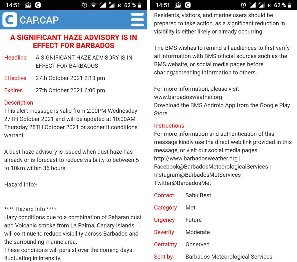
- Dust Layer
|
- By Jurgen Starck <weather at turtle48.de>
- Date: Wed, 27 Oct 2021 15:23:16 -0400
|
|
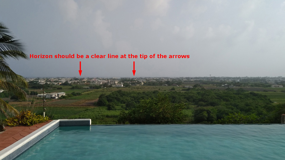
This must be the thickest dust layer I have ever seen. A mix of
Saharan dust and La Palma volcano smoke. Smoke, NOT Ash.
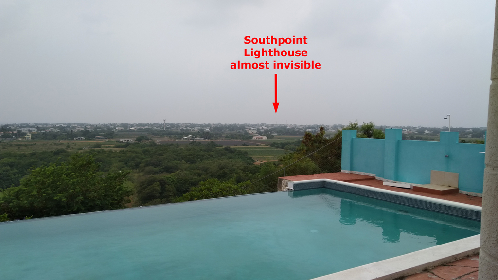
The Barbados Weather Service has published a Dust Haze Advisory.
--
Best regards and stay safe and COVID-19 free! Keep your distance!
Jurgen
Barbados South, near airport (BGI)
|
|
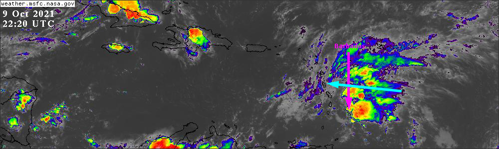
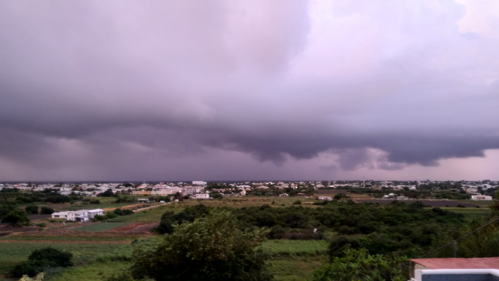
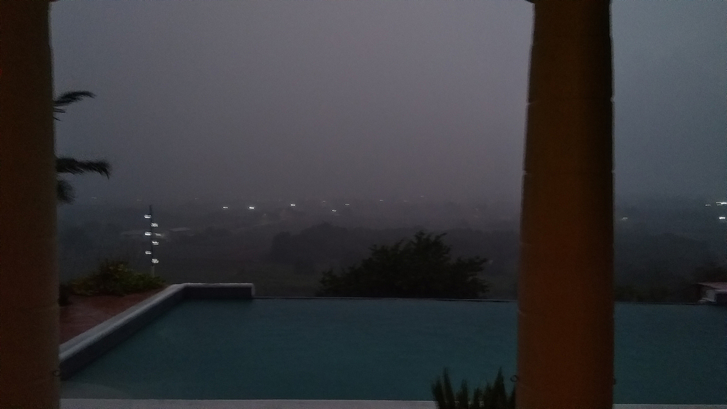
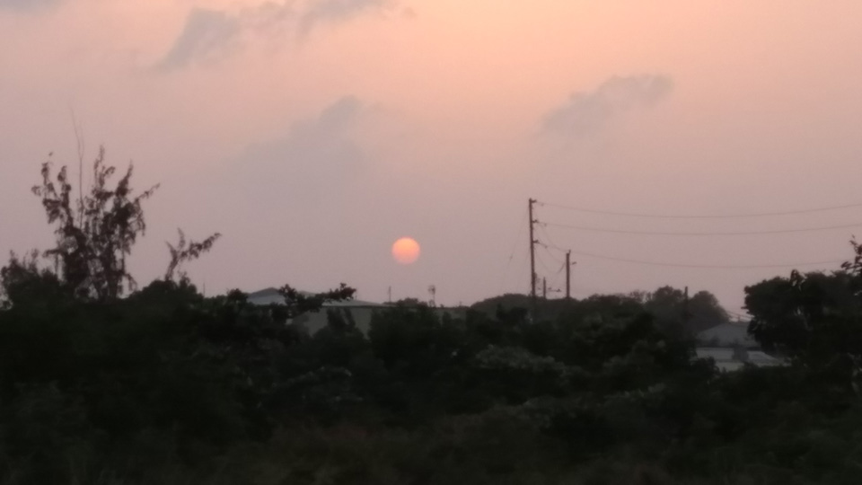
- Trough system over Barbados
|
- By Jurgen Starck <weather at turtle48.de>
- Date: Sat, 9 Oct 2021 21:36:24 -0400
|
|
Good evening to all,
Since yesterday the Barbados Weather Service (BWS) has released a
Flash-Flood-Watch. Today it was upgraded to a Flash-Flood-Warning.
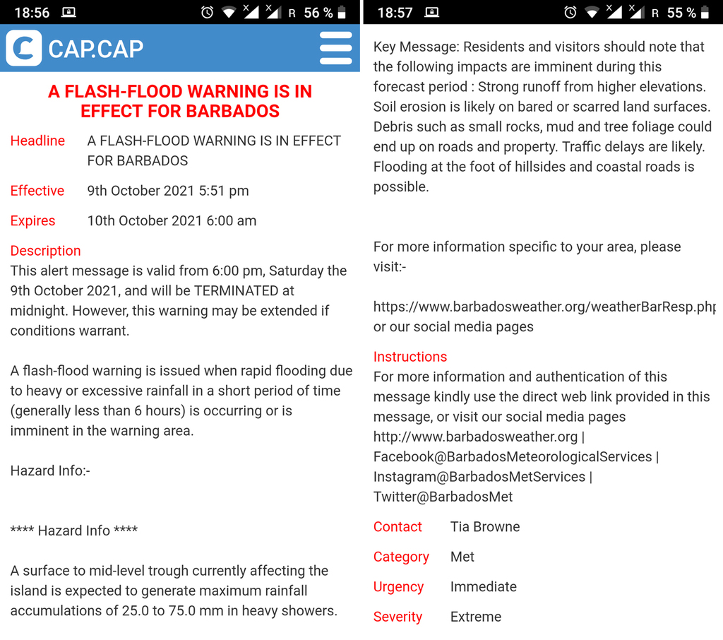
The cause for this warning is a trough system coming our way,
currently visible in the top image of the stormcarib.com front
page. And it may hit some of our neighbouring islands as well.
Here some photos from the ground:
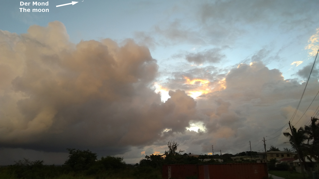
Sunset, photo taken at 17:43:38 local time today.
Looking South, taken 17:44:18.
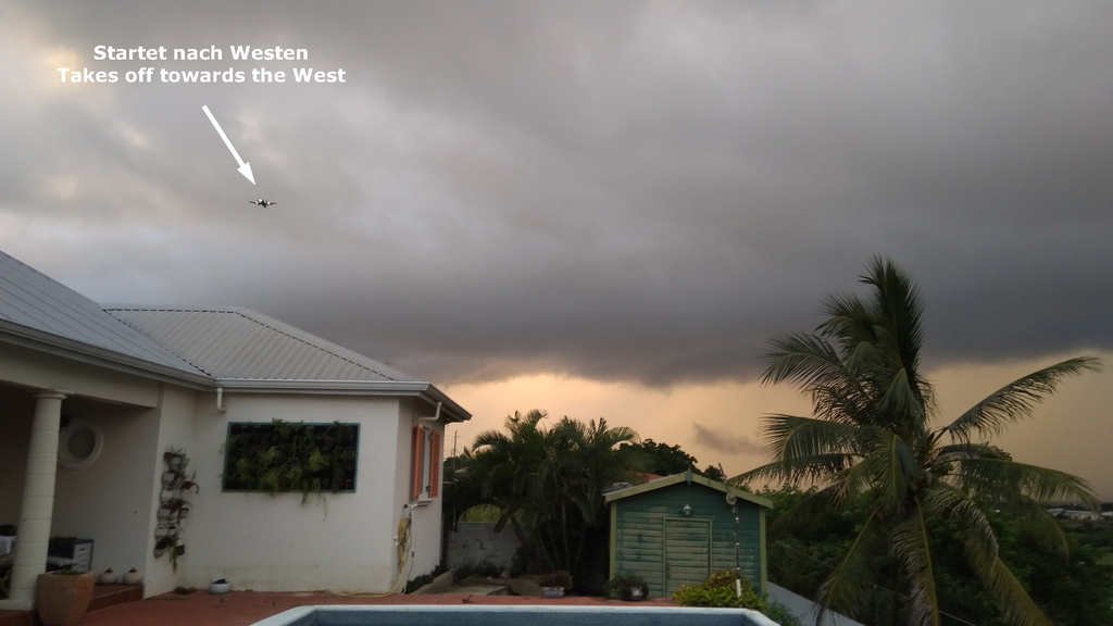
Flights taking off to the West while we had winds coming in from
almost straight South! Taken 17:44:45.
Looking South again, about 11 min. later than the one above.
Taken 17:56:42. (Sorry for the shaken photo, I turned off the
flash light)
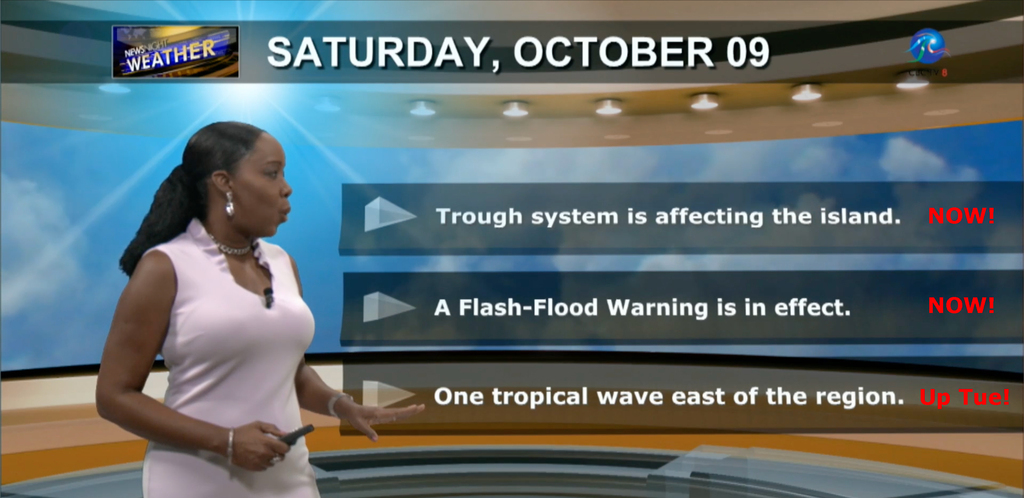
The Weather forecast in the evening news. There is more to come
later next week, about Tuesday (Red remarks by me).
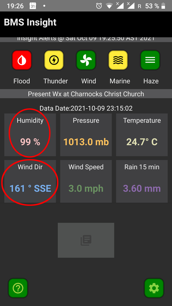
Weather conditions at about 19:30 today.
So much for today. May you all have a good night.
--
Best regards and stay safe and COVID-19 free! Keep your distance!
Jurgen
Barbados South, near airport (BGI)
|
|
- A Goodie
|
- By Jurgen Starck <weather at turtle48.de>
- Date: Sat, 2 Oct 2021 17:46:34 -0400
|
|
I just shot this after I posted my previous post.
Isabel from St.Croix would call this "End of day photo".
Dusted Sunset
--
Best regards and stay safe and COVID-19 free! Keep your distance!
Jurgen
Barbados South, near airport (BGI)
|
|
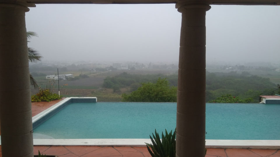
- Dust Haze Warning
|
- By Jurgen Starck <weather at turtle48.de>
- Date: Sat, 2 Oct 2021 17:19:31 -0400
|
|
Good evening all,
Barbados is under Dust Haze Warning issued by the Barbados
Weather Service. In this case visibility is down to 5-10 km. This
is important for small vessels going out to sea with no
sophisticated navigation tools like GPS or radar equipment on
board. It is also important for people with respiratory problems.
On the ground it looks like that:
In reality the haze look worse than in the photo. The camera
tried remove some of the haze.
--
Best regards and stay safe and COVID-19 free! Keep your distance!
Jurgen
Barbados South, near airport (BGI)
|
|
- Sam he's a funny fellow
|
- By Peter Allen <stilettocruises at yahoo.com>
- Date: Fri, 1 Oct 2021 08:29:02 +0000 (UTC)
|
Thank god Sam has turned North and left the Lesser Antilles in one piece.Of
note when this hurricane was East of Barbados packing 150 mph winds we never
got any surf on the east coast,the surfers were in dismay,one of them told me
it got up half decent Wed afternoon but nothing huge as one would expect as it
was  moving at 7mph.Now it's back to 150 mph and there are high surf warnings.
|
|
- TS PETER what Barbados got of it
|
- By Jurgen Starck <weather at turtle48.de>
- Date: Sun, 19 Sep 2021 19:28:39 -0400
|
|
Good evening all,
TS PETER is past his closet point (CPA) to Barbados. We did not
get any rain or wind so far and probably won't get any from it.
Quite the opposite was the case. The feeder bands of PETER have
taken away our normally refreshing breeze for a while, which we
were enjoying during the past weeks.
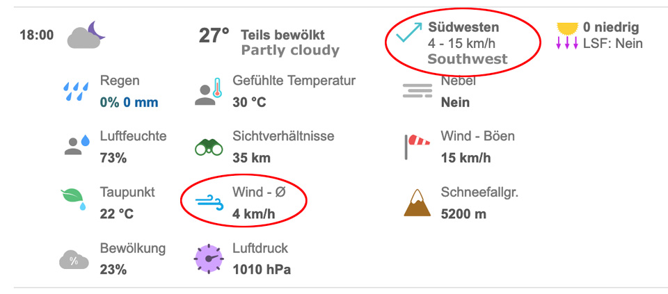
Current weather data at the airport BGI:
Even the Barbados Weather Service was warning about it
beforehand, that it would become a hot day today. And so it was.
That was a new one to me, that the vicinity of a Tropical Storm
can put the sun in charge to cause problems! The winds are still
very low with a westerly component (see graphic above). The latter
had consequences on air traffic with aircraft taking off to the
West and landing from the East.
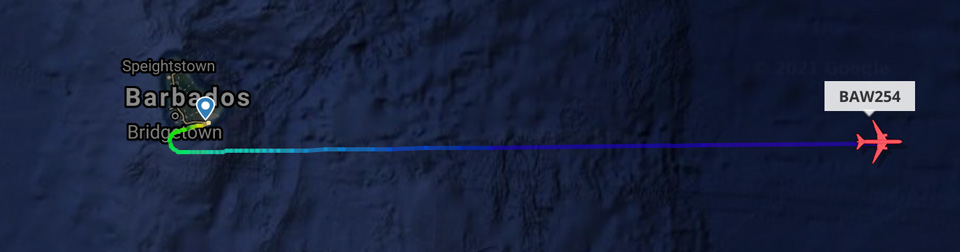
See British Airways regular daily flight # 254 on its flight to
London. Usually they turn to the Northeast as soon as they have
reached a certain altitude, no matter which way they are taking
off. This one today went straight East for quite a while until
flightradar24.com could no longer receive any further position
information. Comparing this with visible satellite photos showed,
that the flight was avoiding one of PETER's large feeder bands,
which it would have crossed if took the normal route. Obviously,
the pilot didn't want to give his passengers the experience of a
Hurricane Hunter mission. LOL!
--
Best regards and stay safe and COVID-19 free! Keep your distance!
Jurgen
Barbados South, near airport (BGI)
|
|
- INVEST 95L
|
- By Jurgen Starck <weather at turtle48.de>
- Date: Fri, 17 Sep 2021 11:15:11 -0400
|
|
Good morning all,
The Barbados Weather Service has sent out
notices that Invest 95L will pass well north of Barbados.
--
Best regards and stay safe and COVID-19 free! Keep your distance!
Jurgen
Barbados South, near airport (BGI)
|
|
- Weather and how we feel it
|
- By Jurgen Starck <weather at turtle48.de>
- Date: Tue, 7 Sep 2021 21:46:34 -0400
|
|
Good evening to all,
in support of Barbara Cannegieter's report from St. Maarten, I
can confirm that we have had a hot day here as well, and not only
today. Also the past days. Many friends here, locals of dark
complexion, are complaining a lot, believe or not! The term "they
are used to it" is no longer valid, and it never has been, because
EVERY human being has the same nominal, healthy body temperature.
Skin colour doesn't make any difference.
Even the weather presenter in tonight's local evening TV news
said that the max. temperature today felt higher than those
numbers shown (contrary to the numbers presented in the graphics
behind her). I have never heard anything like that before!
Also, Barbados has been supplied with 2 advisories of high surf!
Mostly a warning to our West Coast. See attachment.
That's it for tonight.
--
Best regards and stay safe, prepared and COVID-19 free! Keep your
distance and your masks on, get vaccinated, as well!
Jurgen
Barbados South, near airport (BGI)
|
|
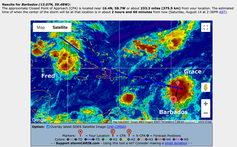
- TS Grace
|
- By Jurgen Starck <weather at turtle48.de>
- Date: Sat, 14 Aug 2021 11:47:27 -0400
|
|
Good morning all,
Nothing much to write. We are having on and off light to moderate
to heavy showers from the outskirts of Grace and thunder in the
distance, probably in the North. The Barbados Weather Service has
issued a flash-flood warning for Barbados as of 10:15am this
morning.
Grace's CPA to Barbados is to come in 3 hours from now.
--
Best regards and stay safe and COVID-19 free! Keep your distance!
Jurgen
Barbados South, near airport (BGI)
|
|
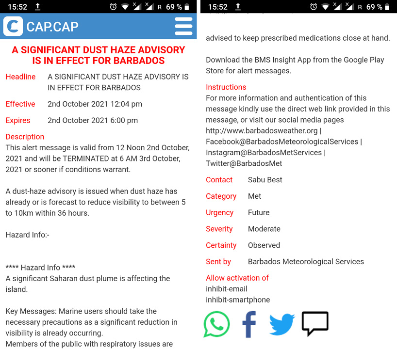
- In relation to INVEST 94L
|
- By Jurgen Starck <weather at turtle48.de>
- Date: Sun, 8 Aug 2021 17:05:23 -0400
|
|
Good evening to all,
I am hoping this works, because it is a forwarding of a CAP.CAP
email, issued by the Barbados Weather Service in HTML-Format,
which is an internet language.
Best regards and stay safe and COVID-19
free! Keep your distance!
Jurgen
Barbados South, near airport (BGI)
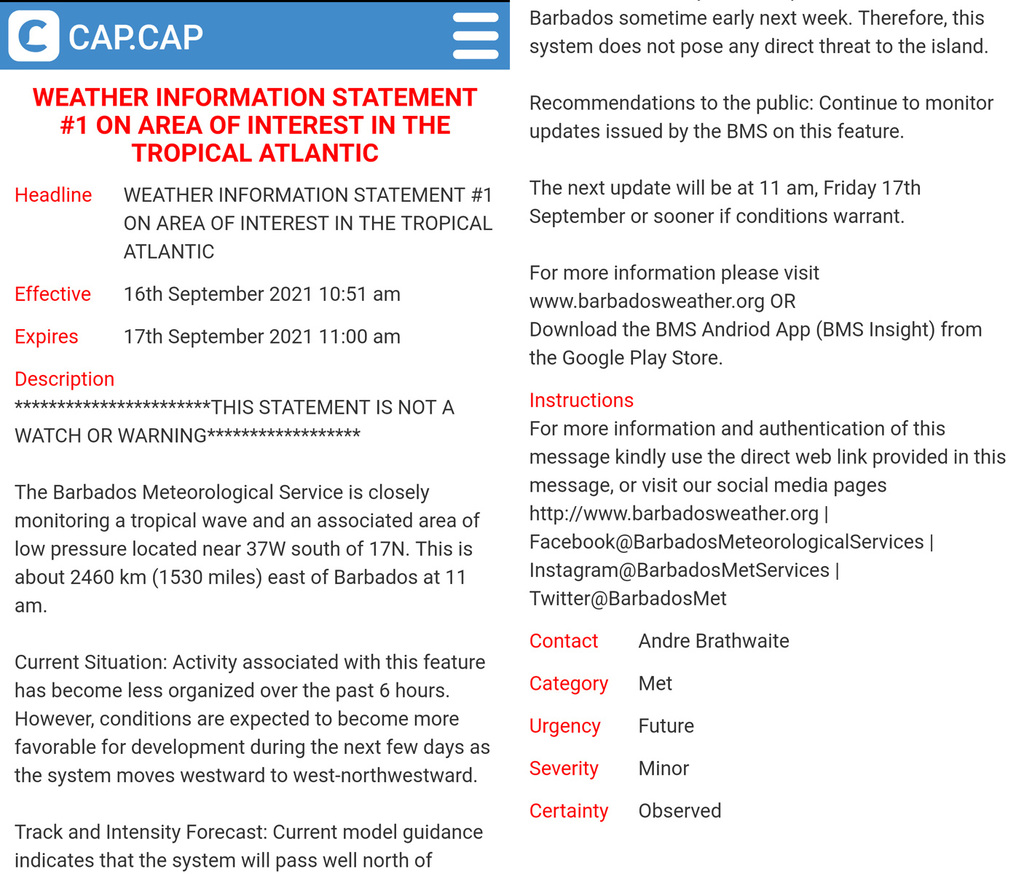
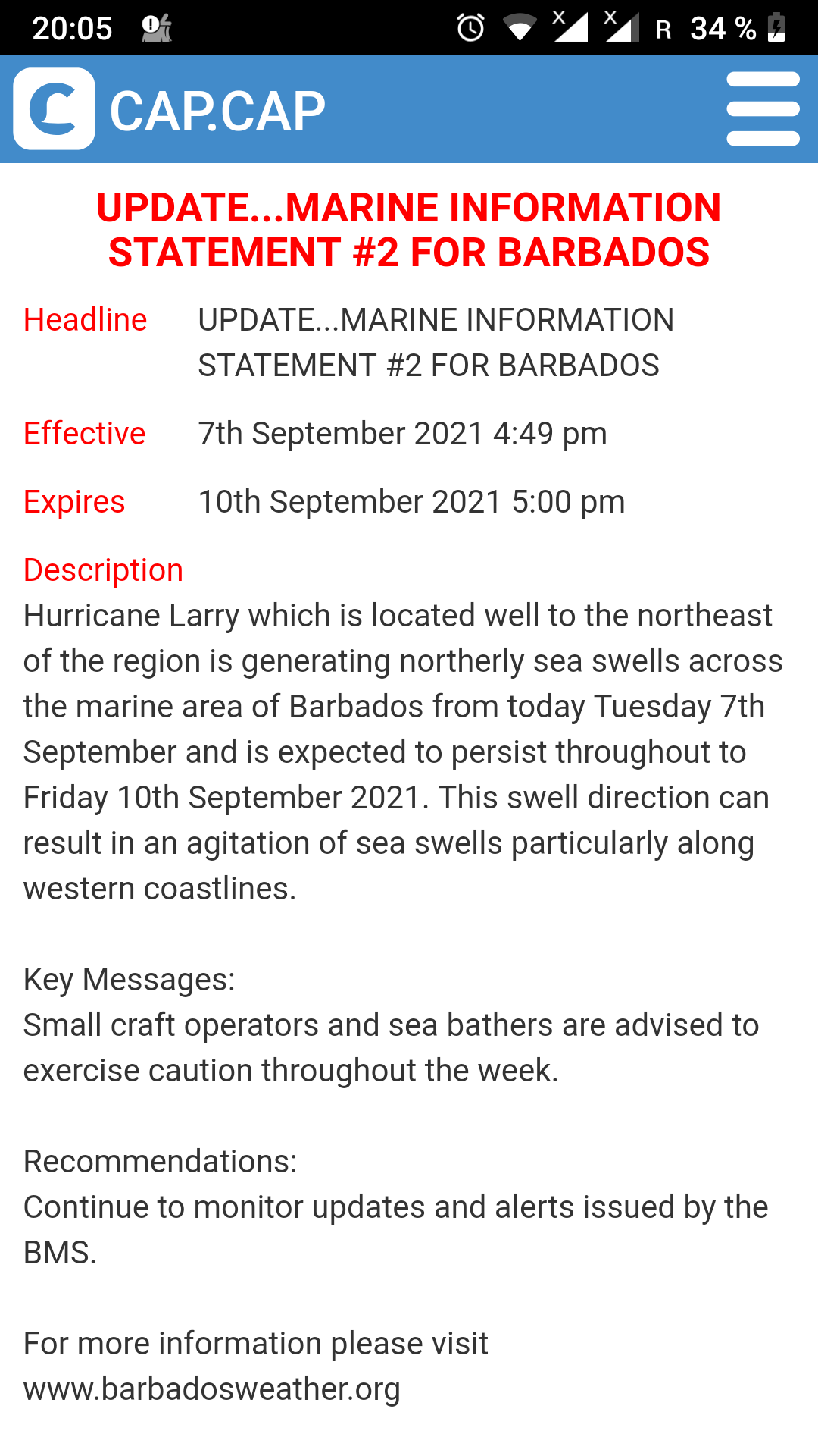
| WEATHER
INFORMATION
STATEMENT FOR
BARBADOS #3 |
| Urgency
/ Severity / Certainty
|
| Future
/ Minor / Observed
|
| The
Barbados
Meteorological
Services continues
to monitor an area
of disturbed weather
associated with an
elongated area of
low pressure located
some 335 miles or
540 kilometers to
the east of Barbados
at 5:00 p.m, 8th
August 2021.
KEY MESSAGES:
****** THERE ARE NO
WATCHES OR WARNINGS
IN EFFECT FOR
BARBADOS AT THIS
TIME.
****** THIS SYSTEM
IS NOT A DEPRESSION
OR TROPICAL STORM.
During the
afternoon, there has
been no significant
change to the
overall structure of
the system.
Convection continued
to fluctuate and the
system remained
elongated and poorly
organized.
Some slow
development of this
system is possible
as it moves towards
the west-northwest
near 10 to 15 mph.
Current forecast
tracks indicate that
the center of the
area of low pressure
should pass north of
Barbados late Monday
evening.
Recommendations to
the public: Monitor
the progress of this
system over the next
12 to 24 hours.
The next update will
be at 6:00 a.m
Monday 9th August
2021. |
| For
more information and
authentication of
this message kindly
use the direct web
link provided in
this message, or
visit our social
media pages
http://www.barbadosweather.org
|
Facebook at BarbadosMeteorologicalServices
|
Instagram at BarbadosMetServices
|
Twitter at BarbadosMet
|
| Barbados
Meteorological
Services |
|
|
|
|
|
|
|
- UPDATE on ELSA damages
|
- By Jurgen Starck <weather at turtle48.de>
- Date: Sun, 4 Jul 2021 08:57:59 -0400
|
|
Good morning to all!
Yesterday was a busy day for all of us down here in "Beautiful
Barbados" (the motto of Barbados). Damage assessment in Barbados
by officials was going on intensively throughout the day. For me,
researching many of the official and news reports.
I am not on any social media, just some messengers, however, I
received some photos and videos from my wife, who is currently
overseas. But putting all of that together, and having in mind not
to bore anyone of you with all of that, took some time of
selecting the right media attachments. After I had posted
yesterday, there was a live press conference at 16:30 o'clock,
hosted by our Prime Minister The Hon. Mia Mottley, on local TV and
internet stream. I have saved a link to the recording and I just
checked back, it still works and I want to share this with you,
see below.
https://www.nationnews.com/2021/07/03/update-hurricane-elsa-press-conference/
For those of you, who don't want to watch the about 2 hours long
recording, there is also a summary of what the various ministries
and utility providers have assessed so far! I have not heard of
any fatalities.
Yesterday and today one can hear hammering and some pumps running
in the neighbourhood and probably all over the island.
May you all have a great Sunday.
--
Best regards and stay safe and COVID-19
free! Keep your distance!
Jurgen
Barbados South, near airport (BGI)
|
|
- Demolisher ELSA, Addendum
|
- By Jurgen Starck <weather at turtle48.de>
- Date: Sat, 3 Jul 2021 16:21:16 -0400
|
|
Good afternoon everyone,
In my last post I forgot to mention, that the water supply
started to come back ad around 23:00 o'clock and the power kicked
back in this morning at 01:00 o'clock.
That's it.
--
Best regards and stay safe and COVID-19 free! Keep your distance!
Jurgen
Barbados South, near airport (BGI)
|
|
- Demolisher ELSA
|
- By Jurgen Starck <weather at turtle48.de>
- Date: Sat, 3 Jul 2021 16:01:00 -0400
|
|
A little earlier as expected, the rain began falling, about two
hours later the winds started to pick up. We had breezy days
before already.
Here is the timeline (using 24hr format):
07:15 Power went off, tap water as well!!! The
water outage was a planned exercise by the Barbados Water
Authority. The outage of power was not planned. It just happened.
Throughout the day a peak of 75% customers of the customers of
Barbados Light & Power were out of power and hence also out of
internet access. I was one of them as you already know. In a later
Media Briefing the spokesperson of BL&P had the guts to brag
about the 25% who were left with power.
10:45 Rain and wind subsided for about 1/2 hour
before resuming again. I am assuming that either the eye of ELSA
was passing South of us or if we have been in the gap between two
feeder bands. I am not sure which it was. However, this time I
have not had the pleasure to be in the eye of the hurricane. But I
had that experience back in 2010 when Hurricane TOMAS visited us
with a full hit! TOMAS was forecast to pass about 25 miles South
of us, but it made a last minute wobble to the North and came head
on to where I live. That was my very first hurricane to be in.
Being in the eye of a Hurricane and outside(!) is a very weird
experience. It is ABSOLUTE silence, no bird chirping, no leaf
rattling, no wind noise, because there is NO wind, no car noise. I
actually lost my balance, due to that silence, and almost fell.
Sorry, for the diversion, back to ELSA.
10:50 Before the wind and rain resumed, I made a
check walk around the house to look for damage. I had to do that,
because just this year we have installed Hurricane shutters, with
them shut being unable to look outside. No damage to talk about,
just leaves in the pool and the one and the other broken garden
plant. Nothing unexpected. I guess, the difference in distance of
the two centres of TOMAS (2010) and ELSA (2021), and then fact
that ELSA wasn't even a Hurricane when it hit us, made the
difference in wind force. We had much more damage with TOMAS.
11:45 ELSA becomes a Hurricane!
11:50-11:57 DEM Media briefing
This briefing via radio didn't say much, just the fact that ELSA
was now a Hurricane, which I had missed. Also, people were urged
not to venture out just to take photos and videos in order to post
them on social media.
12:45 Winds and rain were subsiding. The show was
over for Barbados. A very short impact, because ELSA was in a
hurry, 44km/h forward speed when it arrived here.
16:45 Barbados calls out the "all clear".
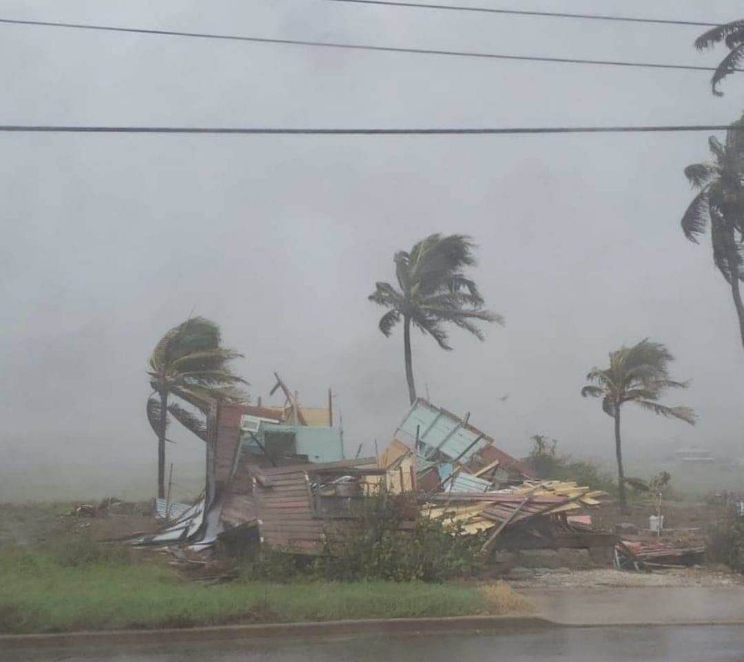
Damages island-wide as known so far:
100% of consumers out of tap water!
75% of consumers out of power!
No mobile service until about 10:45!
177 Homes lost their roofs!
The number of destroyed homes is unknown to me.
Many (not quantified) broken trees and utility poles!
Flash Flooding in some places.
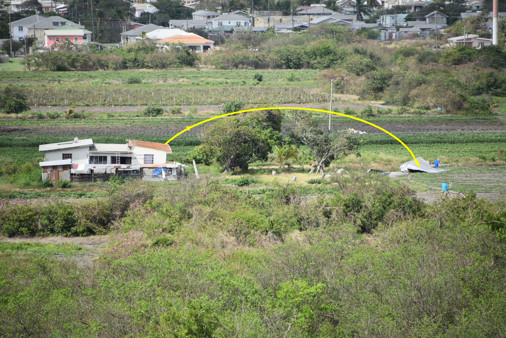
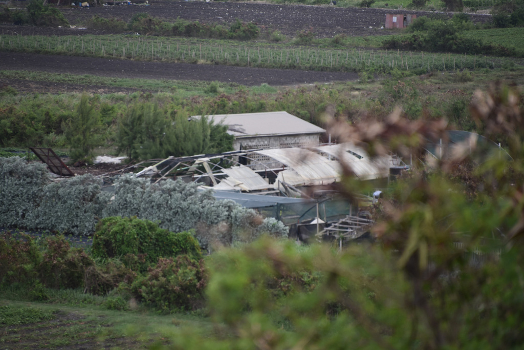
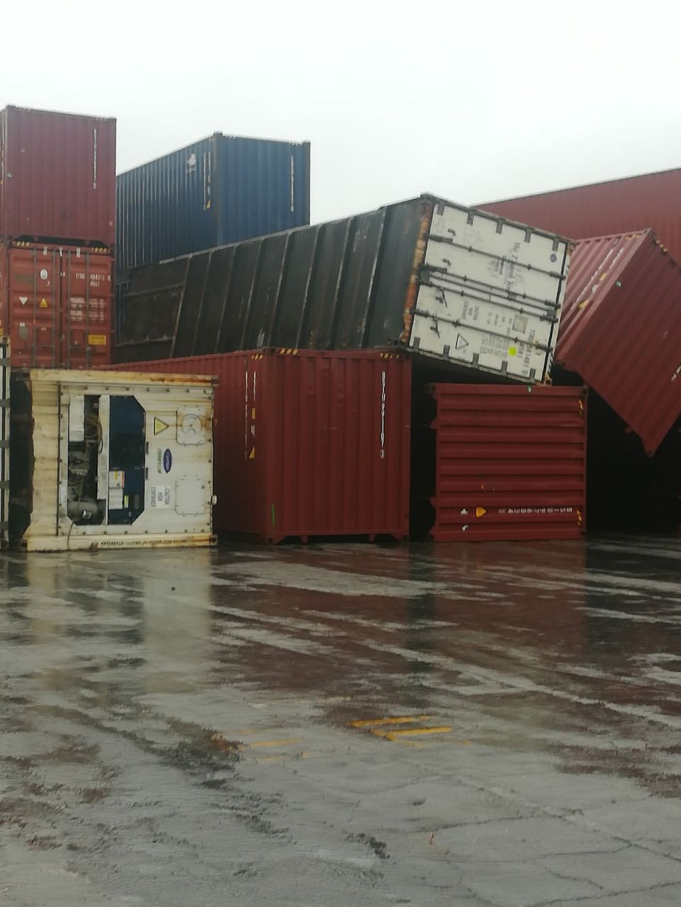
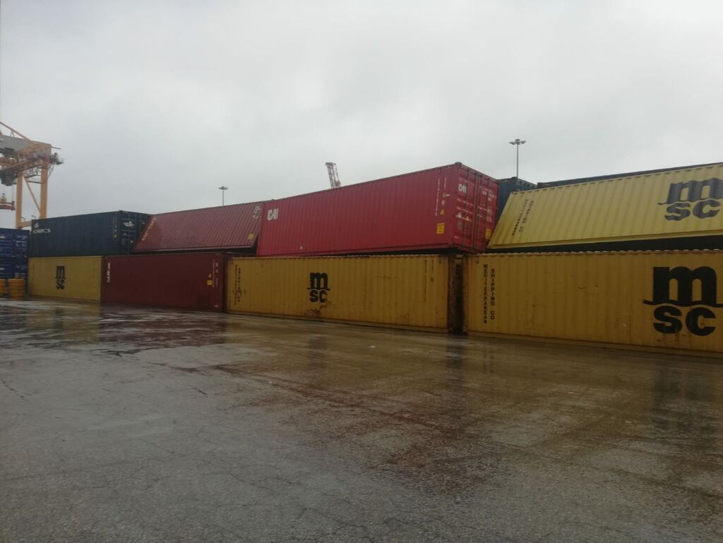
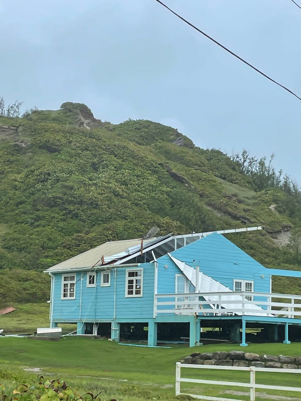
Pictures:
1. A blown roof, 500m South of my home. I only noticed that this
morning,
2. Damaged roofing of a plant nursery to the west-south-west of my
home,
3. Toppled containers,
4. Toppled containers,
5. Destroyed house,
6. Blown roof (video),
7. Blown roof,
8. Social media video.
9. Social media video (watch the pillar falling and crumbling,
shoddy work).
Why did I title this report "Demolisher ELSA", because before I
began writing, here is why (click the link).
https://edition.cnn.com/2021/07/03/us/miami-dade-building-collapse-saturday/index.html
May everyone be prepared!
--
Best regards and stay safe and COVID-19 free! Keep your distance!
Jurgen
Barbados South, near airport (BGI)
Attachment:
20210702_173337_212.mp4
Description: video/mp4
Attachment:
telegram-cloud-document-1-5114011185615733016.mp4
Description: video/mp4
Attachment:
telegram-cloud-document-1-5114011185615733017.mp4
Description: video/mp4
|
|
- H1 ELSA in Barbados
|
- By Jurgen Starck <weather at turtle48.de>
- Date: Sat, 3 Jul 2021 02:45:15 -0400
|
|
Good night everyone,
I will write a report about yesterday later
today. I was out of power, internet and water for the most part
of yesterday. The utilities just came back on around past
midnight. I am getting tired now. And no worries, "I good" as we
say in Barbados. And thanks to all well wishers, it helped
indeed.
Write later.
--
Best regards and stay safe and COVID-19 free! Keep your distance!
Jurgen
Barbados South, near airport (BGI)
|
|
- TS ELSA closing in
|
- By Jurgen Starck <weather at turtle48.de>
- Date: Thu, 1 Jul 2021 21:03:16 -0400
|
|
Good night everyone,
As to the latest information from NHC at 8pm
tonight and the BWS (Barbados Weather Service) at 7:45pm
tonight, TS ELSA has changed gears in terms of forward speed to
currently 28 MPH (44 KM/H).
As to the BWS TV8 evening news weather
forecast rainfall from ELSA is expected to start at 2-3am
tomorrow morning and storm force winds are to be expected to
begin around 6:00am tomorrow.
The closest point of approach is expected to
be around 10:00am tomorrow morning, passing to the South of
Barbados, which will give me a first row seat.
The storm force wind field of ELSA is large
enough to cover entire Barbados even with the distance of CPA.
Rainfall is expected to accumulate to 8-10
inches in total.
The advice to get prepared now would obviously come too late. It
should be common sense anyway.
--
Best regards and stay safe and COVID-19 free! Keep your distance!
Jurgen
Barbados South, near airport (BGI)
|
|
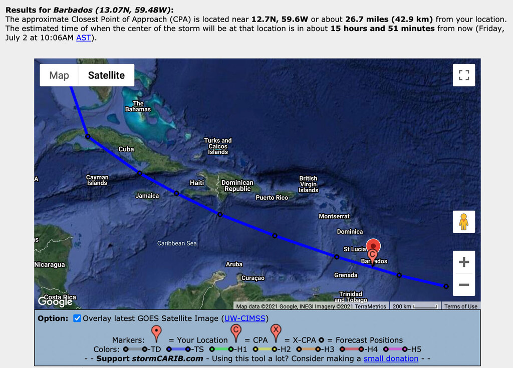
- Potential Tropical Cyclone Five
|
- By Jurgen Starck <weather at turtle48.de>
- Date: Wed, 30 Jun 2021 19:06:39 -0400
|
|
Good evening everyone,
This might be important not only to Barbados, but also to other
near by islands! As to the latest NHC advisory "Potential Tropical
Cyclone Five" has officially been put to "Advisory status" by the
NHS (https://www.nhc.noaa.gov/). Every island North and South of
Barbados this system's path predictions should watch this system
very closely!
--
Best regards and stay safe and COVID-19 free! Keep your distance!
Jurgen
Barbados South, near airport (BGI)
|
|
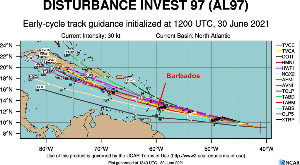
- INVEST 95L
|
- By Jurgen Starck <weather at turtle48.de>
- Date: Wed, 30 Jun 2021 12:18:27 -0400
|
|
Good morning everyone,
A hefty thunderstorm chased me out of bed this morning. INVEST
95L is here. Barbados is again under Flash Flood Warning. More
thunderstorms to be expected throughout the day. According to the
Barbados Weather Service (BWS), the accumulated rainfall can reach
up to 100mm (4").
Of more concern to me is INVEST 97L ! According to the current
spaghetti models and intensity graphs it could become a full hit
of a cat 1 or 2 hurricane! Not good!
This thing should be followed closely!
--
Best regards and stay safe and COVID-19 free! Keep your distance!
Jurgen
Barbados South, near airport (BGI)
|
|
- Two Waves at our doorstep
|
- By Jurgen Starck <weather at turtle48.de>
- Date: Tue, 22 Jun 2021 13:32:45 -0400
|
|
Good afternoon to All,
the Barbados Met Office is observing apparently observing two
Tropical Waves coming our way.
https://www.nationnews.com/2021/06/22/tropical-wave-bring-rain-thunderstorms/
At 8:00am this morning the first one was located at about 300
miles east-south-east of Barbados and the second one 500 miles
away in the same direction. They are moving at 15-20 mph towards
us.
--
Best regards and stay safe and COVID-19 free! Keep your distance!
Jurgen
Barbados South, near airport (BGI)
|
|
- Just for the record....
|
- By Jurgen Starck <weather at turtle48.de>
- Date: Fri, 18 Jun 2021 21:07:07 -0400
|
|
Good evening to All!
I have read a report from Lisette on the Dominica page. First of
all I want to express my deepest thanks to Lisette for her post
and her concerns and well wishes for our people who have lost
their homes or other damage that happened to them! Thank you very
much Lisette for that on behalf of all those affected Bajans! Good
news are, there were no injuries or fatalities reported.
However, it was not a Tropical Storm! Otherwise it would be have
been on the NHC and stormcarib.com records as well. Our Met Office
called it a "Freak Event" because it came out of nowhere and was
very short lived as well. Talking about an hour+ or so, I don't
know for sure.
I am assuming this one was a "Mini-Tornado", as of which we had
one before in 2017. That one occurred just a few hundred yards
north from where I live, two villages above my location. I only
learned about it in the news as well. A very small event in terms
of it's size but it took roofs off of several buildings, even half
of the roof of a large church. Storms are much bigger in diameter.
Hence, I am thinking that the event from 17 June this year was a
"Mini-Tornado" as well. There is no other reasonable explanation
to me.
On my private website I have a report and photos of this 2017
event. What went through here in 2017 were the beginnings of the
much later infamous Hurricane Harvey.
http://www.turtle48.de/en/country/bb/20170818_TS_Harvey/index.html.
Look for the section "Providence, Christ Church" on that page. The
damage of a "Mini-Tornado".
May you all have a good night and be prepared, because "anything
can happen". Citing the PM of Barbados, the Hon. Mia Amor Mottley.
--
Best regards and stay safe and COVID-19 free! Keep your distance!
Jurgen
Barbados South, near airport (BGI)
|
|
- Unbelievable !
|
- By Jurgen Starck <weather at turtle48.de>
- Date: Fri, 18 Jun 2021 07:36:14 -0400
|
|
Good morning to All!
I just read the following two articles in today's online
Newspaper edition. Yesterday night June 17, 12:20 am, all hell was
loose in the North and East of Barbados. For those of us who
always prepare last minute this should have been a wake-up call!
Down South where I live none of that at all, just some rain.
https://www.nationnews.com/2021/06/18/best-freak-event/
https://www.nationnews.com/2021/06/18/mottley-get-ready-anything/
All of this without a warning!
--
Best regards and stay safe and COVID-19 free! Keep your distance!
Jurgen
Barbados South, near airport (BGI)
|
|
- Warnings from Met Office
|
- By Jurgen Starck <weather at turtle48.de>
- Date: Thu, 17 Jun 2021 08:34:38 -0400
|
|
Good morning All,
The Barbados Met Office has published the following warnings:
The tail-end of the tropical wave will be affecting the island.
General Forecast: Mostly cloudy to overcast with the occasional
scattered light to moderate showers.
Winds Across Barbados: Strong easterly to south easterly breeze
from 45 to 55 km/h (28 to 34 mph) and increasing.
General swell information: Moderate in open water with swells
ranging from 1.5 to 2.5 meters ( 5 to 8 ft ) and increasing.
Dust-Haze Forecast Across Barbados: A layer of slight dust haze
will be visible across the island.
--
Best regards and stay safe and COVID-19 free! Keep your distance!
Jurgen
Barbados South, near airport (BGI)
|
|
- EVERYTHING BACK TO FRONT
|
- By Peter Allen <stilettocruises at yahoo.com>
- Date: Thu, 17 Jun 2021 08:07:31 +0000 (UTC)
|
It's 3.50am here and quite windy out of the SE 20+k i'd say with some thunder
showers.At long last some rain and,every door and window is now sprawling open
to let some fresh air in the house because the volcanic ash is now wet.One
thing is normal my weather man the dog is hiding in the bathroom so some more
rain and thunder still to come.I'm actually starting to believe this dog feels
the pressure drop or i need an examination myself lol.
|
|
