
|
|
Caribbean Hurricane Network- 2 0 1 8 Season - |
|
|
| 2018 Atlantic Hurricane Season |
| | Alberto | Beryl | Chris | Debby | Ernesto | Florence | Gordon | Helene | Isaac | Joyce | Kirk | Leslie | Michael | Nadine | Oscar | |
I will write a little recap soon...
Below links to local reports from the special hurricane correspondents on the islands:
|
- Nevis [May 15 14:08] - Trinidad & Tobago [May 9 5:43] - St.Maarten/St.Martin [May 3 18:46] - Anguilla [May 3 18:03] - Antigua [May 2 9:38] - Dominican Republic [Apr 28 18:09] - St.Thomas [Apr 16 14:47] - Grenada [Apr 13 6:38] - Tortola & Virgin Gorda [Apr 3 9:00] - Barbados [Jan 21 8:44] - Dominica [Dec 30 8:20] - St.Lucia [Dec 4 20:45] - St.Croix [Nov 30 17:52] |
- St.John [Nov 9 1:30] - Curaçao [Oct 18 19:03] - Belize [Oct 7 10:21] - St.Vincent & Grenadines [Sep 28 10:39] - Martinique [Sep 28 8:38] - Vieques (PR) [Sep 19 20:53] - Montserrat [Sep 12 21:52] - Haiti [Sep 7 7:44] - Bermuda [Sep 6 9:42] - Cayman Islands [Aug 28 12:19] - Bonaire [Aug 17 5:51] - Puerto Rico [Jul 9 15:00] - Guadeloupe [Jul 9 7:08] |
Following is an archive of all weather discussions Dave and I posted. They are in reverse chronological order, with the most recent storm discussion on top. If you want more background in formation on specific storms, I have found the 2018 Atlantic Hurricane Season section in the Wikipedia a great resource. Also, visit the National Hurricane Center's website for 'best track' data of all 2018 storms. The track map below is from that website as well.
- - 2018 Hurricane Tracks - -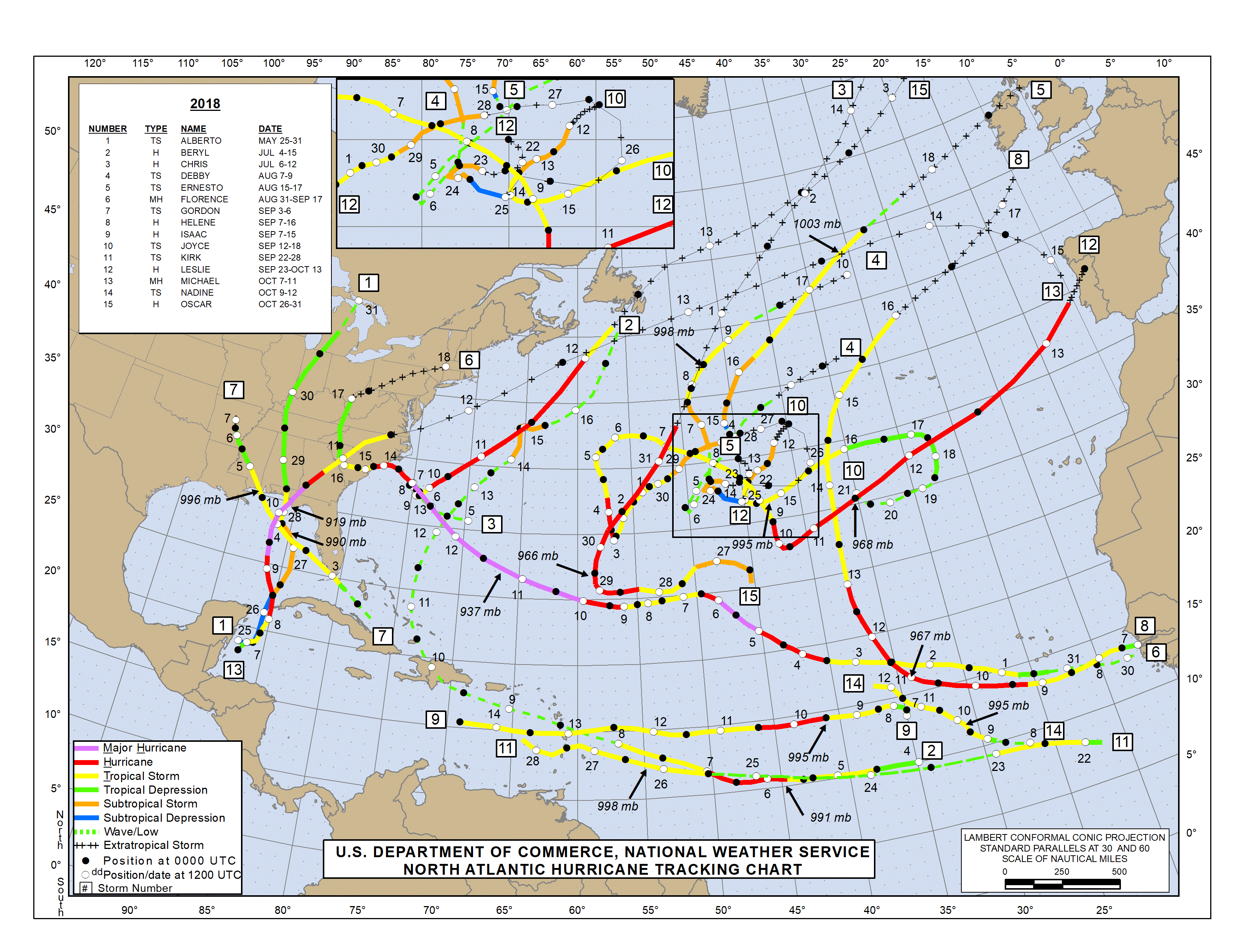
- - Source: National Hurricane Center (click on image for larger size) - -
| - - - 2018 Season - - - |
Weather discussions by Gert & Dave during the 2018 Atlantic Hurricane Season. The homepage with the links to local reports from the islands, latest satellite image, current weather outlook can be found here.
 |
- - - Click on picture for enlargement - - - |
Monday, November 12, 2018 20:45PM EST
- 96L
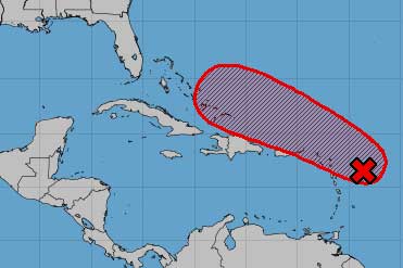 |
- - - Invest 96L and its projected path - - - |
In the Pacific on the other hand, the Northern Mariana Islands got slammed by an Irma-like storm named Yutu yesterday and Mexico earlier by Category 3 storm Willa (which was a Cat.5 just a day earlier). Remarkable about both storms is the rapid intensification. Wunderground reports that Willa went from a tropical depression on Saturday to a Category 5 storm on Monday, a record setting 54 hours, and similar to Maria in the Atlantic last year. Yutu as well went from 75 mph (Cat.1) to 180 mph (Cat.5) in just 30 hours. As you can imagine the situation is not good. The islands, close to Guam, are part of the US Commonwealth. But not sure if that really helps with the recovery seeing what the US Government did for Puerto Rico and the US Virgin Islands.
Finally, check out the pictures from the not-storm related flooding in Trinidad last weekend send in by our special hurricane correspondents. Many aid organizations have offered to help, including Nicki Minaj, who is born there. -Gert
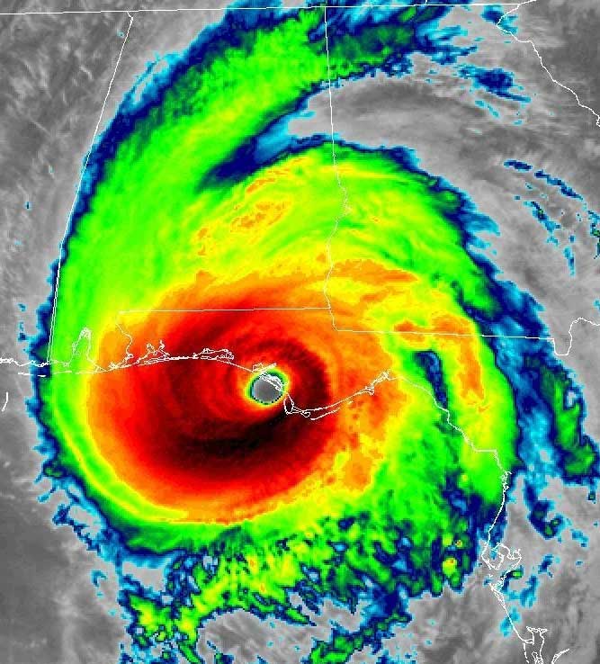 |
- - - Michael making landfall - - - |
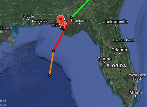 |
- - - Michael relative to Panama City, FL - - - |
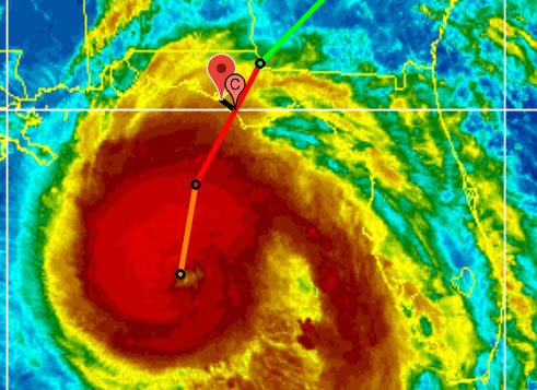 |
- - - Michael relative to Panama City, FL - - - |
Meanwhile, Leslie is still churning around in the Atlantic, it formed September 28 not far from where it is now. But it looks like it is finally on the move, heading towards Madeira and Portugal/Morocco, the wrong way indeed.
Last but not least Michael, which is heading toward Florida, where it will make landfall tomorrow. The storm surge will be the most dangerous aspect of this storm because of the geography of the area. This storm, and esp. when it was just a blob, has already caused a lot of flooding in Central America, esp. Honduras, Nicaragua and El Salvador. Thirteen fatalities have been reported so far... You can use the above tools to see how close the storm can get to you. I have listed several cities along the Gulf Coast to the Closest Point of Approach-tool. But as always, don't focus too much on the exact track. Esp. if you live near the coast be aware of the potential catastrophic storm surge. Listen to the local authorities. If they tell you to get out, do it! Don't be stubborn (=stupid). -Gert
Sunday, October 7, 2018 11:20AM EDT
- Soon to be Michael
Wednesday, September 26, 2018 20:41PM EDT
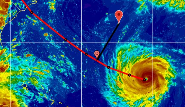
- Captain Kirk
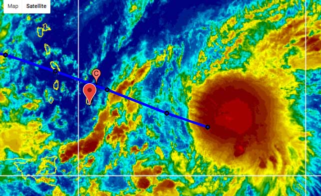 |
- - - Kirk vs. Barbados - - - |
 |
- - - Kirk and wind shear - - - |
Saturday, September 22, 2018 14:55PM EDT
- Brief respite but now...
Tropical depression 11, much closer by us, is not expected to be much of a threat. It is kind of stationary, and about to fall apart and become a tropical wave.
Meanwhile, this morning I saw on TV an interesting report about Vieques, the "Forgotten Island". It showed that the electrical grid has not been restored at all, and that they are totally dependent on generators. The hospital is not operational either, patients fly to Saba for dialysis apparently. See it on the CBS This Morning website. On Sunday there will also be a one-hour special on CBSN about Puerto Rico: Puerto Rico: The exodus after Maria. -Gert
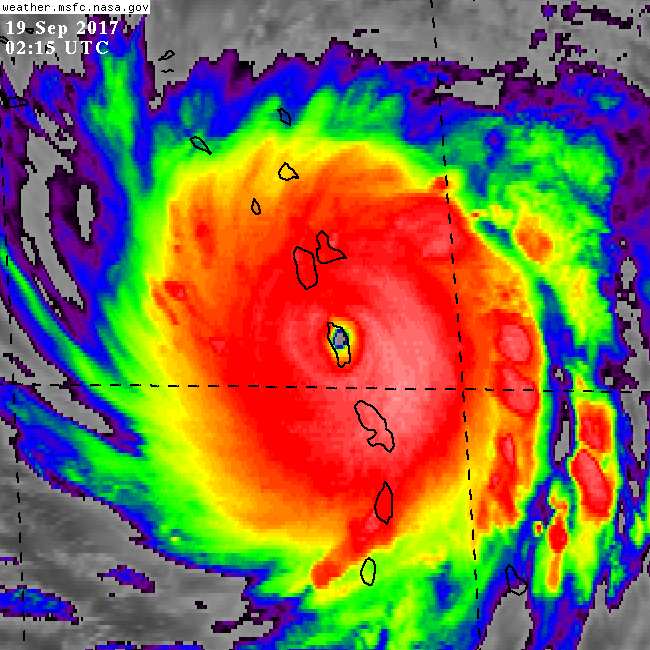 |
- - - Maria over Dominica 2017 - - - |
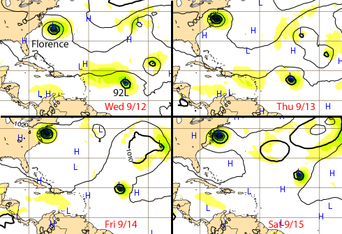
Meanwhile, Florence is taking aim for the US East Coast. Just a heads up if anyone is listening on the East Coast, the European ECMWF model forecast is still (see my earlier posts) predicting a different path than the official NHC forecast. It keeps Florence off-shore for a little while, dipping south, before making landfall close to the Georgia/South Carolina border (around Beaufort, SC, hard to see) and then move inland. Just to keep in mind if you live in Charleston, Savannah, or thereabouts... See Tropical Tidbits (click through the images). Stay safe everybody! -Gert
Wednesday, September 12, 2018 23:07PM EDT
- Florence and the afterthoughts
And anyone on the US East Coast, esp. the Carolina's, Georgia and yes, Florida... don't underestimate Florence! If local authorities are telling you to evacuate than do it! Like I wrote before: don't be stubborn (ie. stupid)! The wind probably won't kill you, but the water (storm surge/flooding) definitely can! -Gert
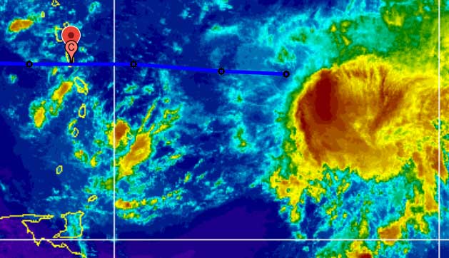 |
- - - CPA for Dominica + storm relative to center - - - |
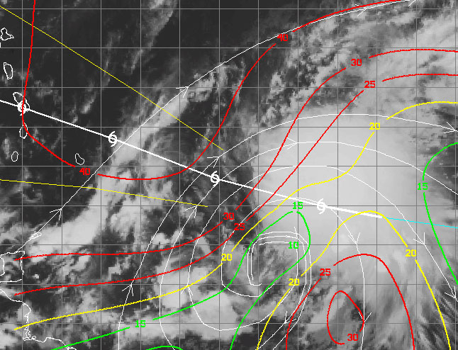
Meanwhile Florence is still a Category 4 storm, it might become even a Category 5 storm before it makes landfall in the US. People in the US can also use the closest point of approach tool to see how close it can get to you. Biggest threat will be storm surge and if it stalls widespread flooding like Harvey. Please heed warnings by local authorities! See also this helpful blog post by Brian McNoldy, a researcher at Univ. of Miami, and who is also part of the Capital Weather Gang of the Washington Post. -Gert
As for Florence, it is now a Category 4 storm, packing 140 mph winds! It should stay safely (350+ miles) south of Bermuda. See screenshot below from the Closest Point of Approach-tool, showing distance vs. size of Florence relative to Bermuda. It is expected to make landfall as a Category 4 storm in the US... If you live on the US East coast, I added a list of US cities to the Closest Point of Approach-tool, so you can see how close it can get to you, and how forecasts are 'trending' over time... See also the Florence tools above for more info. Remember, most storm deaths are due to water (storm surge or flooding), not wind force... In the Carolinas the storm surge could be as high as 15-10 feet, see Jeff Masters' blog at WeatherUnderground. His bottom line: "if you are told to evacuate for Florence's storm surge, get out! And don't wait until the last minute, or it may be too late to save your life.". Don't be stubborn (ie. stupid)!
Finally, two cool animations I received in my email: Close-up movie of the eye of Florence (GOES-16 30s scans) and a GOES-16 loop showing the three hurricanes in the Atlantic. -Gert
 |
- - - Florence relative to Bermuda - - - |
Monday, September 10, 2018 08:54AM EDT
- Historic Sept. 10th
Saturday, September 8, 2018 06:13AM EDT
- Zero to 60
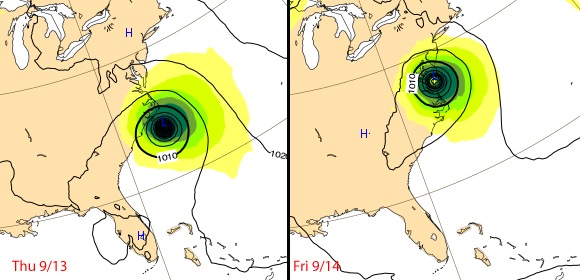
Hmmm, there I thought that Invest 92L would veer nicely to the north. Now the latest model runs show 92L actually heading for the islands! The timing is around Thursday/Friday next week. Still far out, so a lot can still change. The strong high pressure system to the north is pushing this Invest more south. The same for Florence, now expected to pass at a more safe distance of 300+ miles south of Bermuda. The European model (ECMWF) and now the spaghetti plots more so as well (see above) show a landfall on the US coast somewhere. We also have a new 'potential tropical cyclone' close to the African coast. That one looks like it is going north... Lots of storms this year forming so far east. So a lot going on! Stay tuned! Use the tools above to see how close the storms can get to you and more. -Gert
Back to today..., Invest 92L is still just an invest, but that might change in a few days. It looks like it will still move north of the islands. Florence on the other hand is aiming for Bermuda and the US East Coast. Right now (according to my closest point of approach calculator) it looks like that the center of Florence will pass about 200 miles south of Bermuda in 5 days. At that time Florence is forecasted to be a Category 3 hurricane. Hope it will stay that way.
As for the US East Coast, we usually don't cover it (there are many other sources), but I want to stress that although many spaghetti plots show that Florence is staying off shore, the well respected ECMWF (European) model, does not show it (and is often not included unfortunately in the spaghetti plots). It now shows a landfall around Cape Hatteras, Thursday next week, and near Virginia Beach/Norfolk Friday next week (see image I made below). Model forecasts are not reliable this far out, but it is for sure a possibility, so when you live in the US East Coast don't think that this storm won't affect you... -Gert
 |  |
- - - Left: Irma over the Virgin Islands, right: over St.Maarten/St.Martin. Original source: Navy/NRL Monterey - - - | |
 |
- - - ECMWF Model Output for Next Week - - - |
As for Bermuda, the ECMWF model shows that it will go just south of the island (not shown below). On the image you can also see Invest 92L. That one looks like it will not target the islands. Hope that will come true. Use the tools above to asses your risk. Esp. the Closest Point of Approach for Florence will be helpful. I included some locations on the East Coast to make it easy for you guys over there. Stay safe! -Gert
 |
- - - ECMWF Model Output for Next Week - - - |
Wednesday, September 5, 2018 10:24AM EDT
- Heads up!!
Saturday, September 1, 2018 10:58AM EDT
- Climatologically speaking
On another note... we should be happy our islands are not in the Pacific. Four storms are lined up in the image below. Better enjoy the remarkable quietness of the Atlantic! -Gert
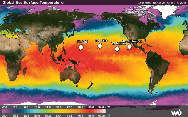 |
- - - Active Tropical Storms (wunderground.com) - - - |
Thursday, August 16, 2018 11:01AM EDT
- 99L
Sunday, July 8, 2018 08:49AM EDT
- 1 Up and 1 down
Friday, July 6, 2018 18:35PM EDT
- July Storm Trio?
Wednesday, July 4, 2018 08:35AM EDT
- 95L
Researchers from U. South Florida publish monthly outlooks based on satellite data. The latest outlook unfortunately shows that this year might be a bad one, with a high chance that the Sargassum will be polluting some beaches through August. It might actually be a worse year than 2015, the worst so far. Unfortunately there is not that much that can be done about it. It is very labor intensive to clean it up, and then what to do with it? There is some good news, a company in Guadeloupe has developed a system that can remove large quantities of Sargassum out of the water using a conveyor belt that dips below the surface. Apparently the 'Sargator' can collect up to 10 tons of Sargassum before it reaches the beaches (see this article). -Gert
But as always, it only takes one big one to spoil your season! Be prepared as best as you can. Check your hurricane shutters and see what you can improve about your house's structure to better withstand high winds and torrential rains... -Gert
June 1 update: Maybe some clarification needed... The researchers did not estimate the number of deaths at about 4600. The 95% confidence interval is 793-8498 casualties. 4,645 (a much reported number) is the average of those two extremes. Other studies have estimated the death toll at about 1,000. Read more in this Washington Post article.
This one sneaked in just before the official start of the hurricane season. This doesn't mean a more active season. But there seems to be a trend of an earlier start of the season over the years...
Incidentally NOAA's Climate Prediction Center came out with their hurricane forecast. They predict a 35 percent chance of an above-normal season, a 40 percent chance of a near-normal season, and a 25 percent chance of a below-normal season. Not really sure how they came to this conclusion because they also write that sea surface temperatures are expected to be near-normal and that a weak El Nino might be forming. This would result in a near-normal or below-normal season. But they also note that "atmospheric and oceanic conditions" in general are more conducive to more and stronger hurricanes forming. I guess they mean climate change, but are not allowed to call it that... See the NOAA website for more.
-Gert
Tuesday, May 22, 2018 21:10PM EDT
- It's time for Invest 90L (Again)
     Comparison TSR and CSU (Colorado State)
                          TSR     CSU
     tropical storm        12      14
     hurricanes             6       7
     major hurricanes       2       3
     ACE index             84     130
The probability of at least one major hurricane tracking somewhere through the Caribbean is 52% (42% is normal). They also publish a spreadsheet with landfall probabilities for the Caribbean and Central America. For example, for the USVI the probability that at least one major hurricane will pass within 100 miles is 16%, for Anguilla (which I guess includes St.Maarten/St.Martin, St.Barths) it is 11%.
The slightly above forecast is based on two major factors, the state of El Nino/La Nina (ENSO) and sea surface temperatures (SST) in the Atlantic. Right now it looks like that the ENSO conditions during the peak of the season will be neutral or maybe slightly positive. An El Nino (positive ENSO) will normally reduce activity, a La Nina the opposite. There is also some uncertainty regarding SST in the Atlantic. Right now the far North Atlantic is cooler than normal, which is a good thing, but the western tropical Atlantic is warmer than normal. The balance of forecasted neutral or slightly positive ENSO conditions and above normal SST results in the slightly above normal forecast of hurricane activity. More technical details on the Colorado State website, or read the blog post by Brian McNoldy in the Washington Post. Regardless what the forecast is, be prepared! Now would be a good time. We for sure don't want another Irma or Maria! -Gert
 |
- - - New GOES-East imagery, focused on N.E. Caribbean (large island is Puerto Rico) - - - |
My website will be moved to 2 new servers. They will be faster and have more memory. Hopefully we will never need this extra power though, because that means another Irma/Maria! Since the operating system will change, as well as newer versions of PHP, MySQL, etc., there might be some glitches. I will try to fix them asap, but I would not be surprised if there will be some downtime. Thanks again to my excellent web host pair Networks! They have been very supportive of stormCARIB. -Gert
Monday, January 1, 2018 19:37PM EST
- 2018
Good evening and Happy New Year!

While 2017 was devastating to many Caribbean islands who still
struggle to recover from the 2017 hurricane seasons events, 2018 will
start off on the same note but positiveness resounds, albeit
tentatively.

Lets pray and hope 2018 starts another period of many years of
relative peace, both worldwide and weather wise!

Dave

Sent from my iPhone
Maintained & moderated by: Gert van Dijken (gert@gobeach.com).
Weather discussions also by Dave McDermott, St.Thomas, USVI.
|
GoBeach Vacations |
| Back to top |