|
|
- - - 2018 Hurricane Season - - -
|
- 1st Tropical Wave -
|
- By Ian Martin Borde <readkrox51 at gmail.com>
- Date: Tue, 12 Mar 2019 19:33:04 -0400
|
Good Night, Stormcarib People of Paradise,
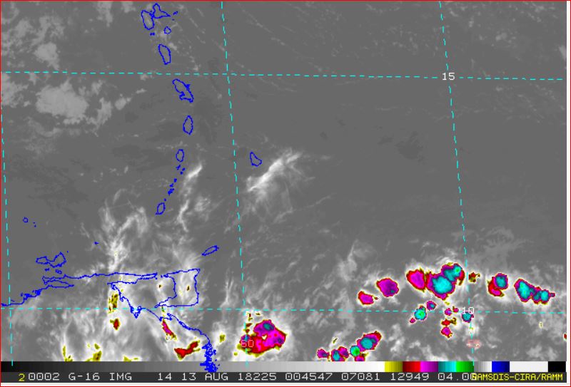
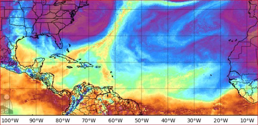
The first (1st.) Tropical Wave of 2019 originating, not from Africa but South America, at 6:30 pm Tuesday 12th March 2019 to affect the Eastern Caribbean. Is more or less centered at 50 W. 15 N. bringing only patches of showers because of the pressure gradient or wind shear. May I say there is copious Sahara Air.
This is March.
These indicators of the wet season started in the third week of February. I don't like how the wet season is shaping up and the low Latitude of High Pressure Systems. It can be said nicely but, Low Pressure is going to burst into all this low latitude high pressure at some point. 'Climate Change' is remedial but traumatic ! (This can be seen in LP's that form west of and south of Texas then push tropical atmosphere all the way to Maine. At that latitude they appear stormy and traumatic but it's just the difference (Pressure gradient) battling it out.)
Closer to home. Carnival, really Trinidad, is a safer place than before and the economy is still growing, (with refugees).
Hope that brings out a smile?
God Bless

|
|
- Surprising Night Time Showers.
|
- By Stephen Abouhamad <stephen_abouhamad at hotmail.com>
- Date: Fri, 1 Mar 2019 02:07:20 +0000
|
28/02/19
San Juan Trinidad
Good Night to all the StormCarib readers. Well it seems like we are in our dry season. These days have been extremely hot with very high humidity levels. Looking at the satellite images it shows that the I.T.C.Z is way down in South America with a high pressure
system sitting to the east of the Caribbean islands. So clear skies for the next few days.
But it was very refreshing yesterday to be greeted with evening showers at 10pm local time. Isolated showers from the day time to afternoon humidity which was a welcomed cooling to the earth.
You guys continue to drink lots of water and maximize these sunny days.
Regards,
S Abouhamad
|
|
- Deaf Ears - Opportunities to Catch Water -
|
- By Ian Martin Borde <readkrox51 at gmail.com>
- Date: Sun, 10 Feb 2019 03:22:54 -0400
|
I am throwing out again an idea from a post I made the year before Hurricane Irma and Maria.
Long ago my forefathers put stones in the river for us to bathe and learn to swim and more importantly for a large container like a bucket to be able to catch water.
Adding to this weatherwise: The sun is on his journey north. And, The ITCZ is growing in Latitude. Thereby mixing the Eastern Caribbean weather with The South American systems, ... ! There will be times of heavy (moderately heavy) and controllable precipitation before the rainy season.
THIS IS GOOD FOR STORING WATER.
IN THE DRY SEASON AND DURING FLOODING PRECIPITATION IN THE RAINY SEASON.
Preventing people form storing water (and thereby distributing it). Because you have a monopoly or for monetary reasons will be legitimate if the islands had a close to 100% water supply.
One has to be guided constantly by the 'Intention' of The CONSTITUTION.
God Bless 
|
|
- Bump in The Road -
|
- By Ian Martin Borde <readkrox51 at gmail.com>
- Date: Sat, 19 Jan 2019 23:02:16 -0400
|
Hi Folks,
Don't forget to book (everything) for Carnival 2019 in T&T early.
1st. System: There is an unusually greater chance of more than moderate showers tomorrow Sunday. However no way near Hazardous.
2nd. System: The good-weather breaker about to slam the east Coast (southern east coast) of USA. Is going to give the entire eastern Caribbean Really, Really rough seas. Night time temperatures will most likely fall lower than 70 C. This is a period of Global Warming. Things are different.
In other words these night time temperatures may, just may, be hazardous !!
I don't know nothing except that God is alive and well ! The same yesterday, today and tomorrow, . . . 


|
|
- Saharan Dust
|
- By Buffalo Soldier <kellykerr68 at gmail.com>
- Date: Mon, 7 Jan 2019 20:27:33 -0400
|
Hi all
Just a quick check in. Well today was the first day of school and I survived. It's not easy returning to work after three weeks of vacation but eventually I will get back into the school routine my son seems to have already adjusted.
The weather today was sunny but breezy. The met office issued a warning that Saharan dust will be in our area come tomorrow and it will linger for a few days. They are warning persons with respiratory illnesses and allergies to be vigilant.
Last year the Saharan dust gave me a terrible eye infection. My eyes were bloodshot, painful and very sensitive to any form of light. Whenever light entered my eyes I would receive a stabbing pain in my eyes. I thought I had pink eye but that was quickly ruled out after an eye exam.
Since then when the dust is around I have to always use eyewash to irrigate my eyes every few days to prevent the pile up of dust in my eyes and another infection.
I have included a pic from my garden. Bye for now.
Kelly 
|
|
- New Year's Greetings
|
- By Buffalo Soldier <kellykerr68 at gmail.com>
- Date: Mon, 31 Dec 2018 20:31:10 -0400
|
Hi to the stormcarib family.
The weather here in Tobago is very cool and very very windy , the seas are really rough and there is a rough seas bulletin in effect. For the month of December there has not been much rainfall and as a result the trees that lose their leaves during the dry season are turning yellow and are losing their leaves.
It is predicted that the dry season here in our neck of the woods will be harsh. So I will see how that goes. Well I have one more week of vacation remaining so I am just trying to enjoy it. School reopens on the 7th of January so it's back to work soon.
I want to wish everyone a bright and prosperous New year 2019. I wish everyone happiness, success and good health and also may the weather be kind to us all in the upcoming year.
I have included a few pics of the weather today and our cat Puss Puss enjoying the sun.
Bye for now. Kelly

|
|
- Merry Christmas -
|
- By Ian Martin Borde <readkrox51 at gmail.com>
- Date: Tue, 25 Dec 2018 05:15:06 -0400
|
Merry Christmas !
Quote:
"Be not afraid of the darkness, for that is where you'll see the light."
The painting is that of my daughter's aunt,
'Kathy MaKay'
Season's Blessings, . . . .
|
|
- Phew ! Can Disaster Officially End! (Please?)
|
- By Ian Martin Borde <readkrox51 at gmail.com>
- Date: Sat, 1 Dec 2018 01:32:14 -0400
|
My Dear and Lovely People of Paradise,
Today begins a season outside of the norm for tropical storms! We should have less;
Flooding, Landslides, Traffic, Battered Buildings and People, Less Beach Erosion and Tidal Flooding, Sweaty Pre-Storm Conditions, Clean-Up Operations, Risking lives helping souls, Damage Control, Expensive (Emotional and Financial) Loss, Embarrassing Lifestyles.
Instead: Lovely Beaches, Sea, Sand and Surf, Sun, Moon and Romantic Rendezvous, Exotic Food and Shopping, Renewed Health, Leisure and Pleasure 24/7, Drinking, Dancing, Entertaining, Discussing, Bathing in Public, Sailing, Surfing, Swimming, Fishing, Hiking, Picnicking, Reading, Media Surfing, (There are a lot more, ... )
Thank God ! Period ! Thank God, for Wind-Shear and Dry Air! Thank God for Intelligence and Selflessness and Community Service.
Thank God, in His Mercy and Peace ! 


|
|
- Sunshine on My Mind -
|
- By Ian Martin Borde <readkrox51 at gmail.com>
- Date: Wed, 21 Nov 2018 03:16:09 -0400
|
Lovely dear People of Paradise,
This is a different kind of post. But,
Weatherwise: We should have 2 - 3 (maybe more) days of, Sunshine, Low Humidity, Cool Nights, Normal Pressure, Wafting Christmas Trade Winds, (any early morning rain will be a drizzle, most likely thereafter, ... ), Seas however are not to be trusted.
Mitigating circumstances, That kept back the growth of the Trin'dadian economy have been addressed and WE HAVE GROWTH !
Quote: "The absence of pressure, does wonders, ..." [ref: Ian M. Borde] Or, Do so, don't like so. [Caribbean Proverb]
God is Blessing us Now


|
|
- Hello
|
- By Ian Martin Borde <readkrox51 at gmail.com>
- Date: Fri, 16 Nov 2018 06:14:33 -0400
|
Hi Isabel,
I love your photo of Benji.
Ian
|
|
- Do you remember ? Omar ? (Nicaragua) ?
|
- By Ian Martin Borde <readkrox51 at gmail.com>
- Date: Mon, 12 Nov 2018 20:35:22 -0400
|
I am really, really tired.
Is there any Hope and Peace in all this 'Global Warming & Politics' ?
We All ! We all just had rain that defies Physics. Do you remember the 'O' storm that curved to south Central America. Now we gonna have a 'P' Depression before 15th November.
Is there any way to control and enjoy this train ride !
Be Prepared with Love & Forgiveness In Your Hearts 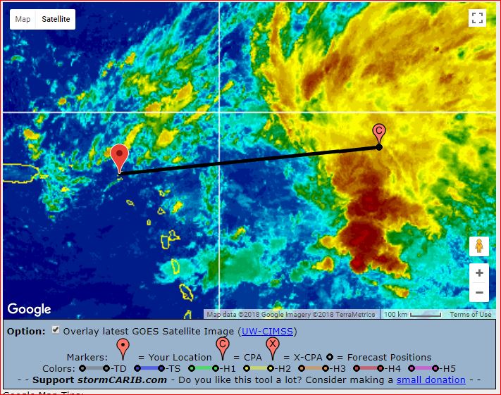
|
|
- Expect more rain -
|
- By Ian Martin Borde <readkrox51 at gmail.com>
- Date: Sun, 11 Nov 2018 04:47:27 -0400
|
Solemn Memorial Day Wishes to all Worldwide, . . . .
Because of their yesterday. We can look forwards to tomorrow.
Weather-wise: Expect more rain.
Salute to the soldiers, past and present ! 


|
|
- Here we go again, (but with notable exceptions) !
|
- By Ian Martin Borde <readkrox51 at gmail.com>
- Date: Wed, 31 Oct 2018 14:36:40 -0400
|
Dear People of Paradise,
First the bad news: The attached release by the authorities is depressing even for me. I had enough ! The good news: The focus is well adjusted and in keeping with lifesaving procedures. It is publicly timely. The public are no longer tongue in cheek to say, Global Warming!
Let's leave politics out of this and strive for the unity that makes Trinidad and Tobago what it is.
God Bless 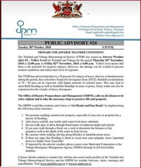
|
|
- Report From Trinidad
|
- By Stephen Abouhamad <stephen_abouhamad at hotmail.com>
- Date: Wed, 24 Oct 2018 13:25:26 +0000
|
24/10/18
Trinidad and Tobago
Good Morning to all.
Well what a few days we had in Trinidad and Tobago. Only now it seems we all are getting back to normal. Everyone is putting their furniture and what ever they could salvage outside to dry. Clean up is still in progress.
Lots of brooms and mops as we all try to get back to normal. First time we have experienced something like this in Trinidad and Tobago but we all know it would not be the last in our history. No we are just on the look out for diseases as our clean up efforts
need to be detailed. Hope everyone remains dry and gets back on their feet.
Regards,
S Abouhamad
M Abouhamad
|
|
|
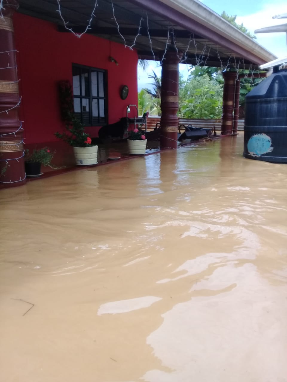
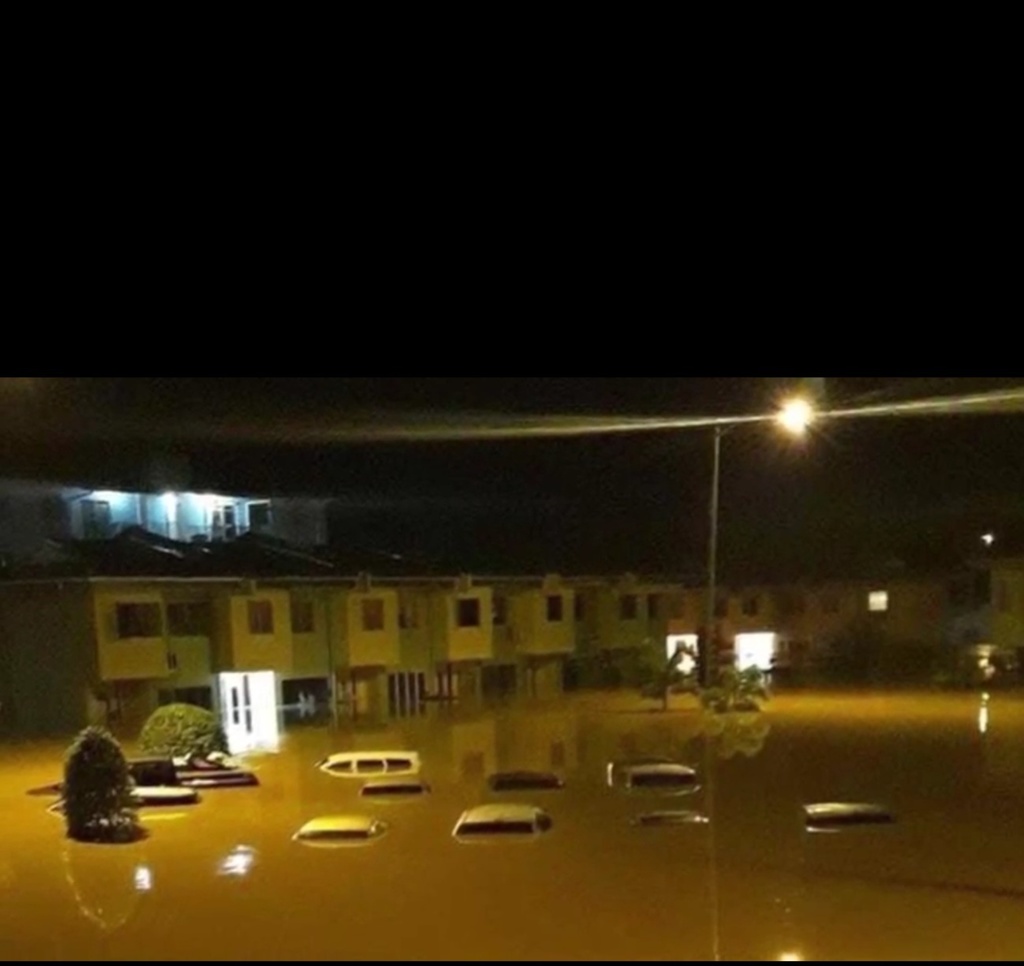
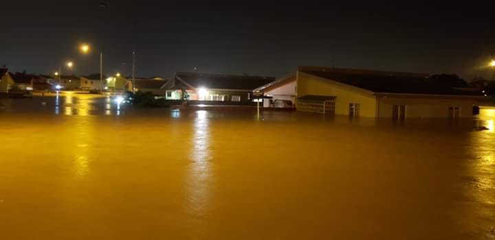
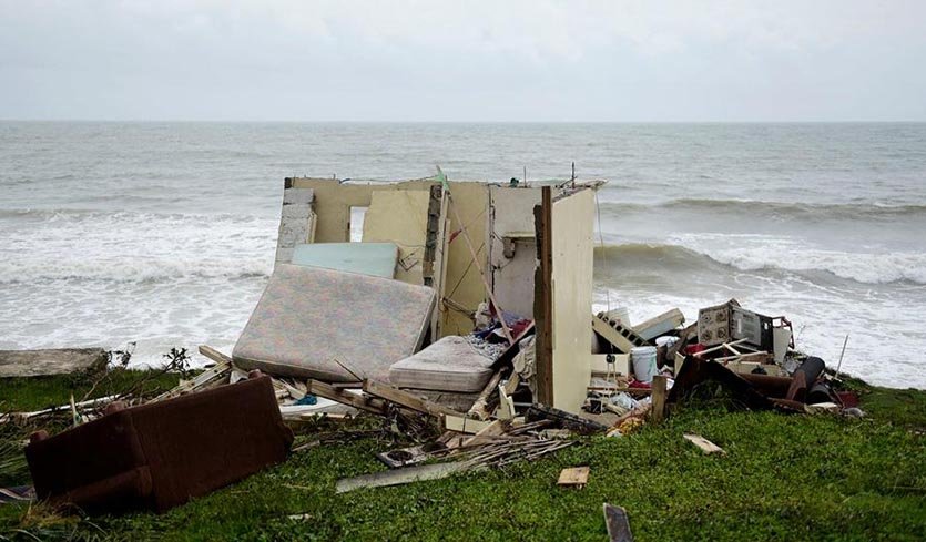
- Hello - Pictures of Flood in Trinidad
|
- By Janice Camps <jgcamps52 at msn.com>
- Date: Wed, 24 Oct 2018 05:54:31 +0000
|
|

|
|
- Flooding in Trinidad
|
- By Janice Camps <jgcamps52 at msn.com>
- Date: Wed, 24 Oct 2018 03:55:29 +0000
|
|
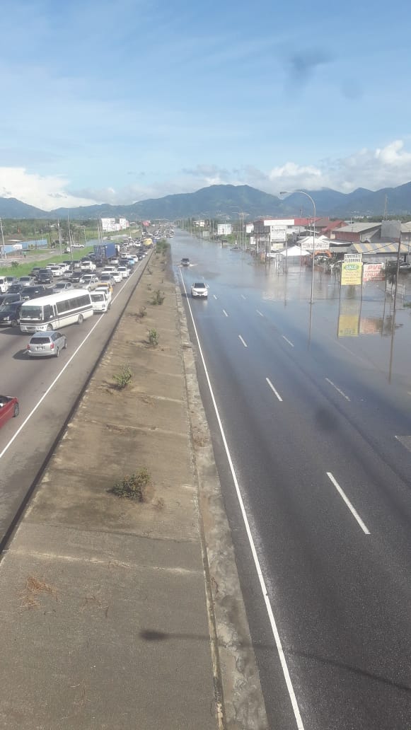
Hello.\,
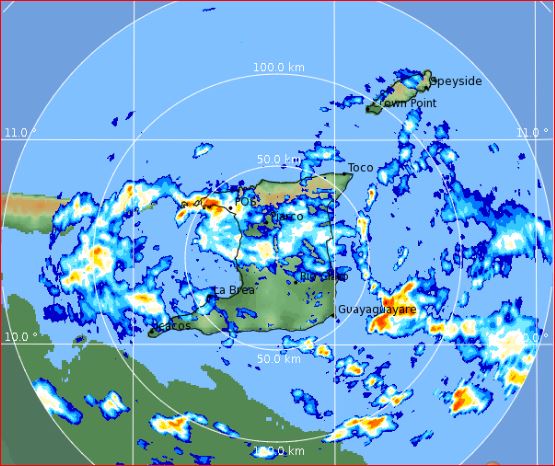
On Wednesday, Thursday and Friday 17,18, 19 October, we had exessive heavy rainfall, especially on Friday, It rained from 8 am to about 7 pm at night throughout our island. Tobago, our sister reported small flood in one area, but our larger island, Trinidad
got the worst of the floods.
Several of our very large rivers, especially the Caroni river which flows through Central and part of the east of the island and goes towards the sea, overflowed its banks and shut down our north to south highway..which is one of our main highways.
Several communities and their homes, and business places, in Central and East are still underwater. a small area in the north, had flood waters flowing through its streets, that water has subsided. Many people had to be rescued. Hundreads of people's houses
were flooded and the roads impassable and under several inches of water.
Today the water has flowed away from parts of the highway and the road is now passable, but all other local roads in those listed areas are still underwater.
Lots of people had to be sent to Centres in their respective areas. the Government,The Police, Fire Service, Disaster of Preparedness and other organizations and citizens of our country have come together to help rescue, counsel and feed the people who are
displaced and cannot return to their homes. It is a very sad situation. We have never had a flood of this type before with so many rivers bursting their banks
The North West, parts of the East and the South of the island had no floods. I live in the South and some of my family live in the North West, so we have been fortunate not to.have floods in our area.
Finishing this message on 23/10/2018
Water in some areas have gone down but other areas are still under water. Most people have got help or are in centers hettingbcsted for. Dome people are cleaning up..
Today we have had a short shower an then a sunny day.
Will send you some pictures in another email.
Of course I will give you further reports.
Regards
Janice Camps
|
|
- Michelle from Trinidad - Pics
|
- By Michelle Ramsahai <mich.sahai at gmail.com>
- Date: Tue, 23 Oct 2018 10:39:32 -0400
|
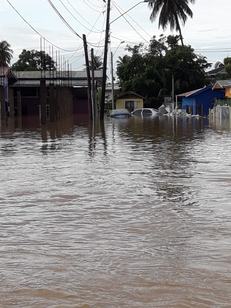

Attachment:
28692257-5cea-464c-a689-43751dd0143f.MP4
Description: video/mp4
Sent from my iPhone
|
|
- Michelle from Trinidad
|
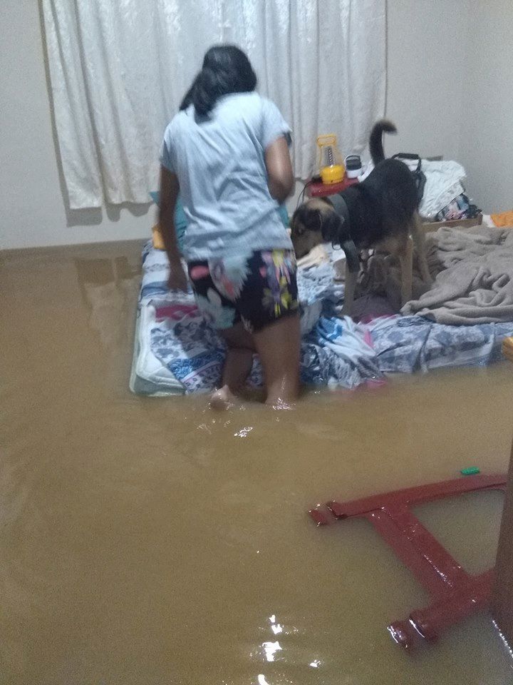
- By Michelle Ramsahai <mich.sahai at gmail.com>
- Date: Tue, 23 Oct 2018 10:37:12 -0400
|
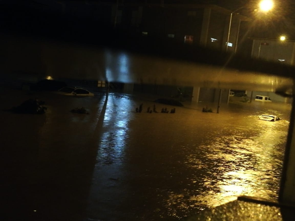
Morning Gert,
Since last Thursday we have been drenched here in Trinidad. Many parts of our
Island like Mayaro, Toco, Caroni and even Tobago have been negatively affected
by flooding. Waters rose as much as 8ft in some of the communities. The island
was cut off being the north and south because the flood waters spilled over
onto the Uriah Butler Highway. The Highway was partly reopened on Sunday and
was opened yesterday after repair works was completed.
The waters have started receding since yesterday, but there are communities
still under water.
Many private citizens and corporate entities, religious groups have been
working together and providing meals round the clock as well as hampers , since
Saturday and this still continues.
Many citizens in these communities complain about the lack of help and support
which are very slow in coming from our Government Agencies. Approximately
120,000 persons are said to be affected by these floods.
I know you may have already been updated about our current situation but I’m
going to send you a couple pics that was sent to me by one of my employees.
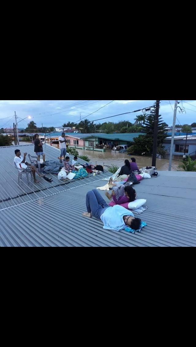
This family lost everything. When the waters started rising they escaped to a
Neighbours House with just the clothes they were wearing.
Michelle
Sent from my iPhone
|
|
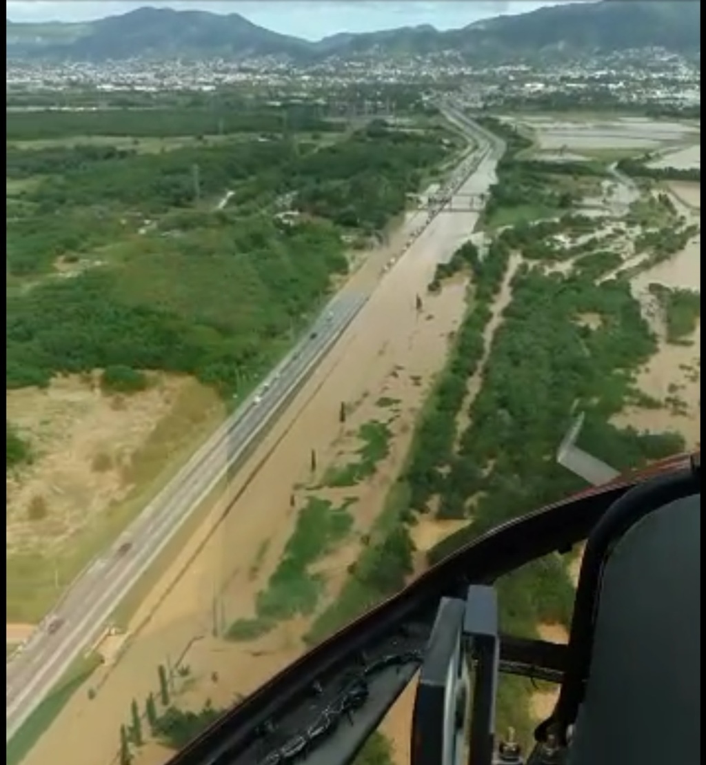
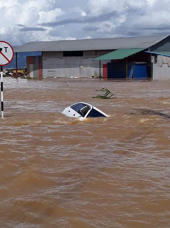
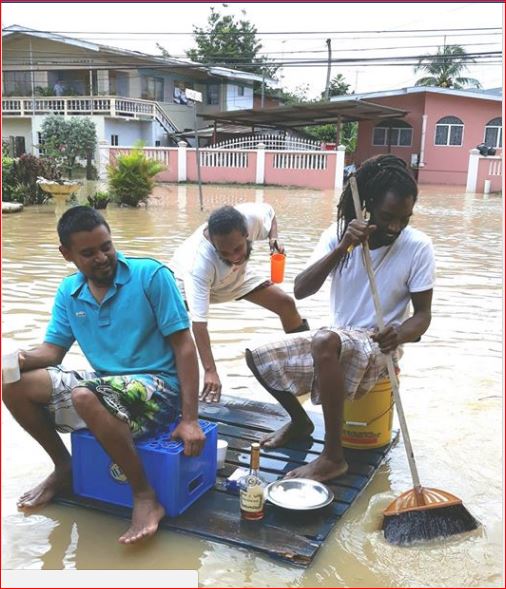
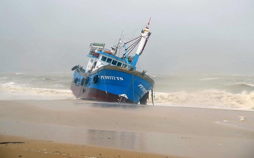
- Update on catastrophic flooding in Trinidad
|
- By Adesh Nanan <adeshcnanan at gmail.com>
- Date: Mon, 22 Oct 2018 16:07:53 -0400
|
|
Dear Gert The island was hit with three days of persistent rainfall beginning on Thursday last. It was the I.T.C.Z. that influenced the weather pattern and flooding was severe in the North East and Central parts of the island. Over one hundred and fifty thousand people were affected with the volume of water that entered their homes . In one particular housing development in La Horquetta , the water was up to the windows .The residents lost everything since the water rose very quickly and they had to fight for survival. Today there is clean up occurring in certain areas where the flood waters have receded, but in other areas there is persistent rainfall and there are reports of flooding in new areas.It is difficult to comprehend that there is still water left in the clouds. The worst is over and now the clean up begins. There has been an overwhelming humanitarian effort from people all over the island to assist with food stuff and other necessities. There is so much loss of livestock and crops but thankfully there was no loss of life. I have attached footage from a flyover of the main highway and the flooded parts of central and north east of the island as well as pictures from flooded communities.
Dr Adesh Nanan


|
|
- Update -
|
- By Ian Martin Borde <readkrox51 at gmail.com>
- Date: Mon, 22 Oct 2018 16:03:49 -0400
|
Good Day, Good Everything, People of Paradise,
Attached to this post are two videos of what it is like to witness everyday for 5 - 6 days in what can be considered a safe area in a country devastated by a Deluge.
Imagine this river as a tributary. Which it is. Then imagine the main rivers;
On the flat On the banks At high tide Roadways and Bridges Without trees Without adequate sanitation and drainage In populated areas.
Besides river flooding in the East and Central. Where they have been rendered homeless. There are landslides reported everywhere. West and South too.
Most roads have been impassable at some point.
The video of the river in front my gallery/home has been doing this everyday for 5 - 6 days. (and nights).
DON'T TRY TO IMAGINE THE NIGHTS, ... !!!!!!!!
God Bless
Attachment:
VID_20181021_151733.3gp
Description: video/3gpp
Attachment:
VID_20181021_151903.3gp
Description: video/3gpp
|
|
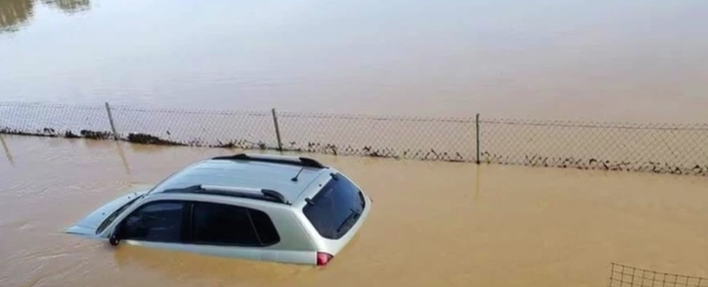
- Flooding in east & central Trinidad
|
- By Jorge Abreu <jorgeabreu27 at hotmail.com>
- Date: Mon, 22 Oct 2018 19:11:36 +0000
|
|
Pics from Trinidad after the very active ITCZ and tropical waves dumped record rainfall on the islands during the last few days. There has been no official confirmation on any fatalities, but some 120,000 people are said to be affected
|


|
|
- P E A C E & U N I T Y -
|
- By Ian Martin Borde <readkrox51 at gmail.com>
- Date: Sun, 21 Oct 2018 09:37:42 -0400
|
Hearty Good Day to All The Good People of Paradise,
There are three attachments, ...
In the weather forecast image one can see three things.
a) The ITCZ Trough is still over us and continuing, ... b) Wind-Shear is to the East, off Mayaro. (Very Strong and position for now) ! c) The wind-shear is giving us a sunny day.
Quote: Three things can't be hidden. The Sun, The Moon and The Truth !
Almighty God have Mercy Attachment:
2018-10-21ST
Description: Binary data

|
|
- Catastrophic flooding in Trinidad
|
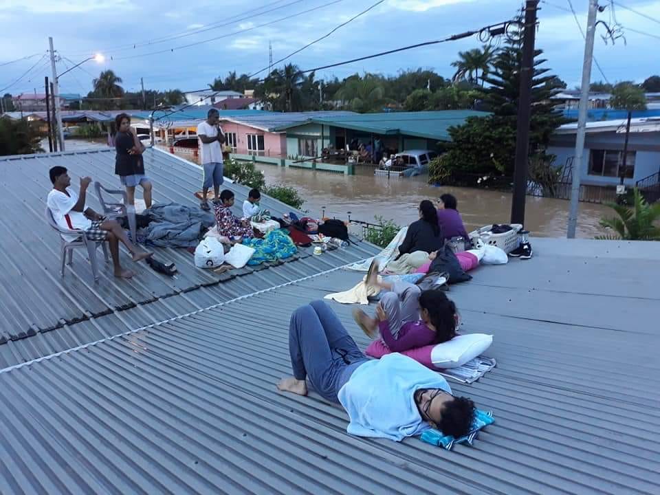
- By Christine Westmaas <chrisalis1003 at yahoo.co.uk>
- Date: Sat, 20 Oct 2018 14:36:51 +0000 (UTC)
|
|
Trinidad is experiencing catastrophic flooding and many people have been rendered virtually homeless at least until their homes can be emptied of flood waters and cleaned. Flood water covered vehicles and were up to roof level in some places. Some marooned families spent last night on their roofs. The country has to mobilise to bring food and other vital supplies to the thousands who have been affected. The highway between San Fernando and the north is completely blocked and the highway running east-west was impassable yesterday evening and last night. The Met. Office says that more rain is coming and that the active ITCZ will remain over the country for the next few days. Riverine flooding is at Red Level. The flooding is terrible. Many rivers have overspilled their banks.
|
|
- S t a n d b y -
|
- By Ian Martin Borde <readkrox51 at gmail.com>
- Date: Fri, 19 Oct 2018 18:57:38 -0400
|
"The picture is not going to be nice tomorrow morning !!!!!!!"
THE CLIMAX OF MISFORTUNE IS TONIGHT !
"Emergency personnel will have to come out Not just standby, specially for evacuees". This is an eventuality not a possibility !!!!!!!!
I am not including graphics or scientific evidence.
This is not preparation! This is Implementation !
Pray Mercy, God Almighty ! |
|
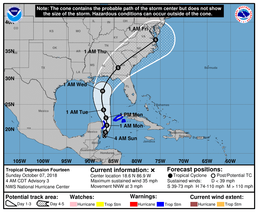
- (Marginally) below Dangerous TW within 36 hours
|
- By Ian Martin Borde <readkrox51 at gmail.com>
- Date: Mon, 15 Oct 2018 07:36:43 -0400
|
I am 45 minutes late for an important start to the week. But, I am not going to do 'apologetics' to all the bandwagonists. And, Just leave you with what NHC says;
A tropical wave extends its axis along 51/52W from 08N-21N,
moving west at 10-15 kt. A 700 mb trough is depicted by model
analyses with the wave, and there is a local maximum in TPW. A
recent ASCAT pass shows that the tropical wave is well-defined at
the surface with 25-30 kt winds from 16N-18N within 60 nm of the
wave axis. Scattered moderate to strong convection is noted from
15N-18N between 48W-52W. Scattered showers are noted from 19N-
22N between 46W-50W and along the wave's axis south of 13N. It is
likely that the tropical wave along 44W will be merging with this
wave over the next 24 hours. Expect plenty of convective activity
near and in between both waves. Moisture associated with these
waves is likely to enhance showers and thunderstorms over the
Lesser Antilles Tuesday into Wednesday, and this activity will
spread to the eastern Caribbean Sea during the middle of the
week.
Please, Besides being EXPENSIVE ! DISASTERS ARE EMOTIONAL !
Please, downplay the trauma, please.
JUST ADEQUATELY PREPARE, . . . , and HELP WHERE YOU COULD, . . . .
God Bless ! |
|
- 'H a i t i', Mon Plus Cher, ... ! -
|
- By Ian Martin Borde <readkrox51 at gmail.com>
- Date: Sun, 7 Oct 2018 06:14:47 -0400
|
Haiti,
Please keep us informed of this significant tremor and the events of any aftershocks, ... I am monitoring in Trinidad. And I am quite, quite Sure, Jamaica is monitoring as well !!
Weatherwise for The Eastern Caribbean:
There is a 55% chance in way less than 36 hours there will be three low pressure systems. Nothing to be over-anxious about. But, it will be sadly hysterical, If you throw 'caution' to the wind.
Standing By 
|
|
- Winter Seas (this weekend) -
|
- By Ian Martin Borde <readkrox51 at gmail.com>
- Date: Fri, 5 Oct 2018 13:26:27 -0400
|
A very dear, "Hello!" to All the People of Paradise,
Very Encouraging, ... ! Keep the posts coming, ... !
I noticed the sea conditions for this weekend are very similar for the seas during December and January when it is Dangerous. Please don't take risks this weekend.
Having said that ! It is not Winter and You should hold on to the last of summer. When the met office and you are given a chance to enjoy Mother Nature, ... !
Unwind and Enjoy 

|
|
- The Bright Side -
|
- By Ian Martin Borde <readkrox51 at gmail.com>
- Date: Fri, 28 Sep 2018 18:45:47 -0400
|
Tomorrow Midday and Sunday should be Sunny.
I will however be actively doing my part.
God Bless 

|
|
- Rain and thunder in Trinidad this morning
|
- By Christine Westmaas <chrisalis1003 at yahoo.co.uk>
- Date: Fri, 28 Sep 2018 13:29:58 +0000 (UTC)
|
After a quiet night, south Trinidad has been experiencing heavy rain since about 8.30 this morning. We have had a lot of thunder too. Flooding may be on the cards. |
|
- KEEP REPORTING OVERNIGHT !!!!!!!! -
|
- By Ian Martin Borde <readkrox51 at gmail.com>
- Date: Fri, 28 Sep 2018 03:20:11 -0400
|
Sorry,
I was overworked and unwell night before and had to get some sleep tonight.
For those who don't have direct access to Gov't to Gov't specially overnight will make quite a few NGO's (Non-Gov't Organisations) aware and RESPOND immediately ! It will be REAL and ACTUAL response.
CALL for H E L P
Ian 
|
|
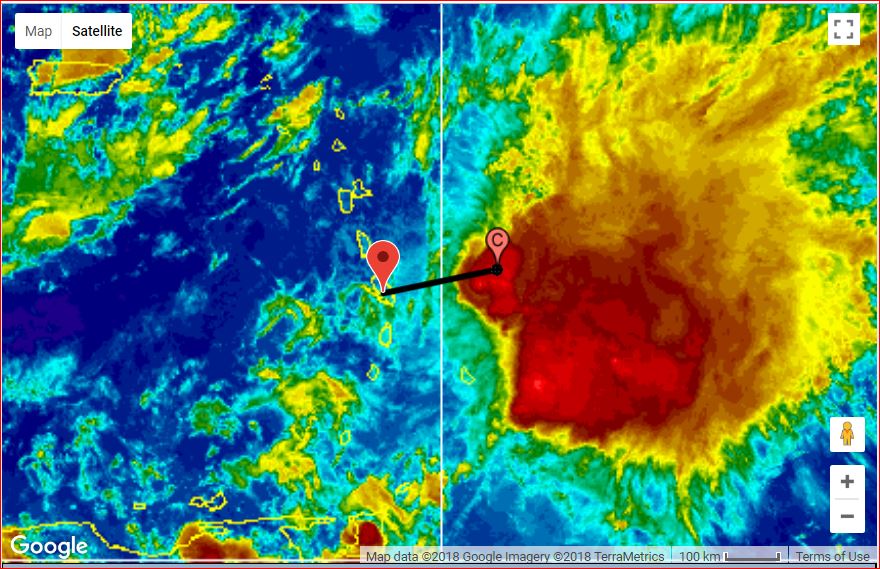
- 'Kirk' - Wind Contact with Martinique -
|
- By Ian Martin Borde <readkrox51 at gmail.com>
- Date: Thu, 27 Sep 2018 16:35:13 -0400
|
My Dear People of Paradise,
It appears that Chris from Grenada is very correct. 'Kirk' is Not stationery. The Centre not eye, is moving ahead. And has made contact with Martinique. It's trek is northern Martinique not south of Martinique as well. If you looking for the blob to hit you. It appears, The winds are already HERE !! Seek shelter !!!!!
Trinidad is being aware of a disturbance nearby in its weather conditions ! and I see the St. Kitts, Montserrat area in the picture.
My take, seeing contact, is: It will NOT reach Cat 1 at landfall. Neither Wind nor Rain.
COASTAL AREAS AND WATERWAYS TILL SATURDAY MORNING WILL BE DOWNRIGHT DANGEROUS!
Standing By 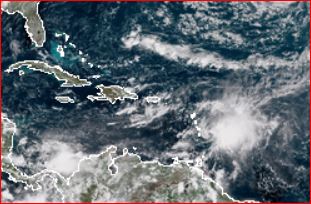
|
|
- Hot, still night
|
- By Christine Westmaas <chrisalis1003 at yahoo.co.uk>
- Date: Thu, 27 Sep 2018 02:08:38 +0000 (UTC)
|
In south Trinidad (San Fernando), it is uncomfortably hot and still and the mosquitoes are brutal. We wait to see whether we will have as much rain as we anticipate tomorrow. It does not take too much rain for us to experience flooding in some areas, including some parts of our capital, Port-of-Spain. there has been some lightning here too but there has been no thunder. Keep safe, all! |
|
- Dear Chris,
|
- By lisa poliah <natalie45.lp at gmail.com>
- Date: Wed, 26 Sep 2018 22:26:38 -0300
|
I have just seen your post regarding those who are critical of your information on Stormcarib. Do not be deterred. I have not posted in quite awhile and I have been following your contribution on TS Kirk. Each person within the Stormcarib family if I may, offers information and perspectives that are valuable to the Caribbean community as a whole. Local weather agencies have their share of missteps and misinformation at times, I have seen evidence of this and they are often corrected by members of the public. As citizens we are much more aware and enlightened and we no longer solely rely on one channel for information. Your reports have been timely and knowledge based. Keep doing your thing!
Best Regards,
|
|
- Fw: StormCarib posts
|
- By Christine Westmaas <chrisalis1003 at yahoo.co.uk>
- Date: Thu, 27 Sep 2018 01:00:04 +0000 (UTC)
|
Chris Bolt,
Please do NOT stop posting from Grenada! Your posts are factual and not at all sensational. I enjoy what you write and I am sure that I speak for loads of others too. As I said to you, this is OUR community and we are united by our common interest and linked through our posts. I look forward to reading more from you. Christine. Trinidad.
|
|
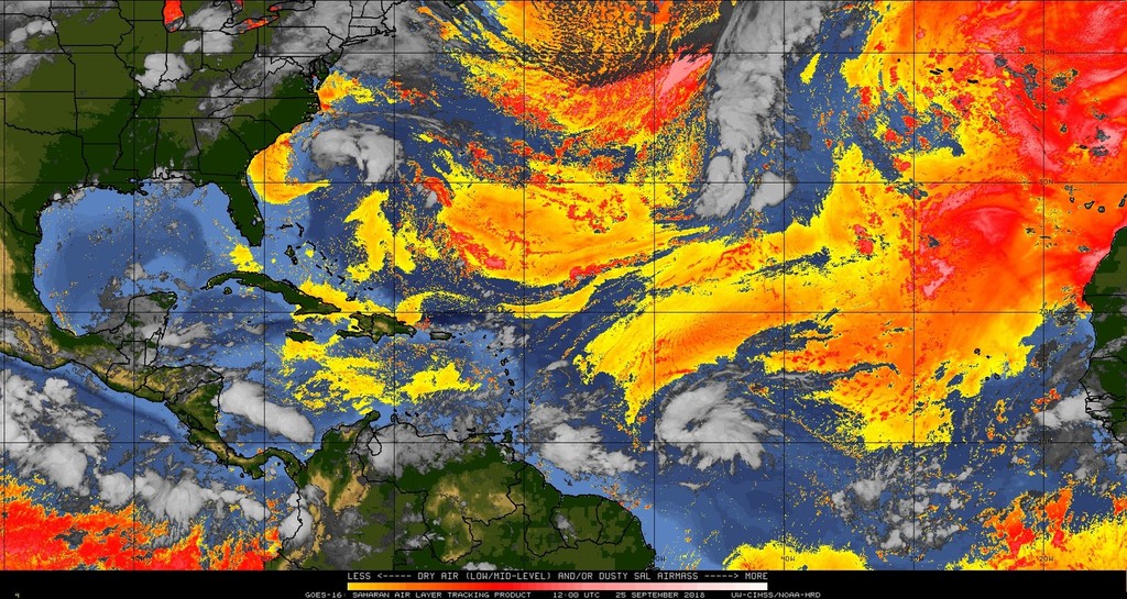
- Fwd: Wave before a Wave (for T&T) -
|
- By Ian Martin Borde <readkrox51 at gmail.com>
- Date: Tue, 25 Sep 2018 09:30:56 -0400
|
Good People of Paradise,
There is a TW blob with maximum moisture potential going to affect Trinidad & Tobago lunch time specially in the south.
Winds - Negligible, 15 mph. Precipitation - two (02") inches. (some areas more, ... ) Seas - Normal, (until Thursday morning, Wednesday night).
There will be a slight, very slight burst of clear conditions before the actual Kirk comes with the same things, but, Longer precipitation, winds and seas. also because of the moisture content of the wave preceding 'Kirk' strong case for landslides with 'Kirk'.
Check the attached and NHC.
Yours, God bless 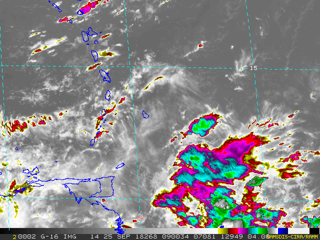
|
|
- Hark! An Invest on the Horizon -
|
- By Ian Martin Borde <readkrox51 at gmail.com>
- Date: Thu, 20 Sep 2018 06:15:12 -0400
|
The nights are getting darker and the sun is setting later as the dawn sleeps longer.
Let this not be a time to grow lazier Is not folly to be wiser, ... !
See attached to form your own opinion of the Invest.
Thank God in His Mercy ! 

|
|
- Caribbean Unity + Solidarity (One History - One Destiny) -
|
- By Ian Martin Borde <readkrox51 at gmail.com>
- Date: Sun, 16 Sep 2018 22:38:49 -0400
|
People of Paradise,
Attached is a graphic of 'ex-Isaac' skirting the south coast of Jamaica. We all pray there are no casualties.
I will be up, if not all, most of the night. Monitoring Jamaica and the Caymans.
God Bless

|
|
- Touchdown Imminent -
|
- By Ian Martin Borde <readkrox51 at gmail.com>
- Date: Thu, 13 Sep 2018 04:41:36 -0400
|
Congratulations, NHC !
You get very, very, very close to 100% in Analysis. Please be advised as per NHC, ie. National Hurricane Centre, Florida, USA.
My thoughts and prayers go out as well to Hawaii where two Capital cities got hit (a double whammy) by storm conditions.
If you use weather conditions in Trinidad as an example of what is coming, ...
"The river is roaring! The atmosphere and air is misty, bleak and damp! There is no wind, no rain, EVERYTHING is still !!! The only signs of life is the river running to the sea."
My Blessing, " In the midst of this calamity, There is Hope ! A saturated overflow of Peace and Goodwill in Hope ! " Attachment:
2018-09-13th Thu 0345am - center 120 miles west of Dominica.JPG
Description: JPEG image
|
|
- A quiet night
|
- By Christine Westmaas <chrisalis1003 at yahoo.co.uk>
- Date: Thu, 13 Sep 2018 02:08:18 +0000 (UTC)
|
It's a very still, quiet night in Trinidad. We had a very heavy shower this afternoon and after that, absolutely no rain. There is some cloud cover but not enough to hide the stars. Wishing us all a safe and uneventful night. Isaac is still forecast to hit Dominica tomorrow morning. Hopefully the impact will be less than feared. |
|
- Heavy rain!
|
- By Christine Westmaas <chrisalis1003 at yahoo.co.uk>
- Date: Wed, 12 Sep 2018 20:18:16 +0000 (UTC)
|
In south Trinidad, the rain has begun in earnest. Leaden skies make the afternoon rather dark. Hopefully we will escape flooding, especially in north and central Trinidad. Dominica, Martinique and Martinique , be safe!
|
|
- Some Threatening Weather Sounds
|
- By Christine Westmaas <chrisalis1003 at yahoo.co.uk>
- Date: Wed, 12 Sep 2018 19:40:28 +0000 (UTC)
|
Dominica, we are following all your reports. We pray that you will all be safe and that you will escape the worst. We are with you in Caribbean fellowship. Here in San Fernando, south Trinidad, it is overcast and we are hearing peals of thunder. It was windy a bit earlier this afternoon but we are alternating between cloying heat and the occasional breeze now. The lightning has just begun. Perhaps Tropical Storm Isaac does not want us to take our 'safe' geographical location for granted. We have had some low-magnitude tremors from time to time but nothing like our frightening 6.0 tremor on August 21. Some buildings were damaged, including one or two schools but we were very fortunate not to have had to deal with any serious damage. We did, tragically, have one earthquake-related death from a heart attack. All our Caribbean neighbours and our American brethren, here's hoping that you remain safe despite the threats that are staring you in the face. May Almighty God spread His loving and protective hands over you. |
|
- P H E W -
|
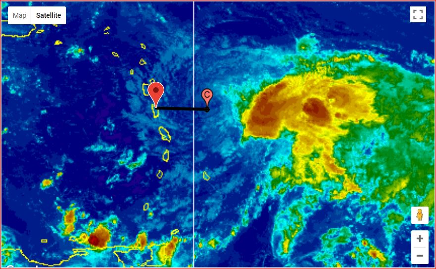
- By Ian Martin Borde <readkrox51 at gmail.com>
- Date: Tue, 11 Sep 2018 03:45:37 -0400
|
My Dear Storm-Watchers and People of Paradise,
YOU NEED TO EVACUATE (Some Permanently), . . .
DON'T PANIC, It's still early. But if, 1) You reside now near the coasts or any type of waterway. 2) a. For Isaac: North of 15 Degrees North Latitude. 2) b. For Florence: North of 30 degrees North Latitude. YOU NEED TO EVACUATE TODAY !!!!!
I admire how NHC has grown!!!!! I am in TOTAL SYNC with its Warnings and Projections, ... ! Not Please do as advised, You have been Warned by NHC. What more do you need?
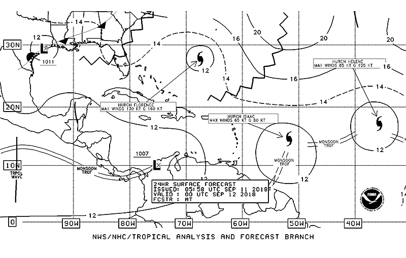
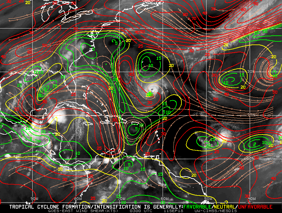
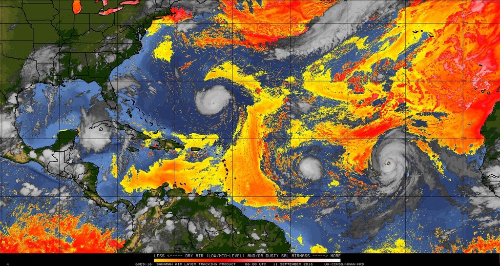
(Just to add a less than 30% chance in my take.) The things that steer a low pressure system once formed is, Winds and Pressure. (There are other factors, like other hurricanes). I am looking at (Isaac & Florence + 95L) between 55 - 75 W. Longitude tonight? The Pressure Gradient and Wind Shear Currents may, cause Florence to dip and Isaac to continue dipping and suddenly rise at 55 W. (Isaac). To be clearer, (less than 35% chance, it's volatile) I see The channel between Dominica and Guadeloupe and southern Puerto Rico getting a direct hit. BUT IT'S NORTH AND EAST OF THE STORM THAT WILL GET OVER 4" INCHES OF RAIN. Winds should average 75 mph. only in the vicinity. Waves will peak at 12' feet.
It's the water away from the eye/center that is PERILOUS !
That's why I am watching 95L. It will steer Florence. Florence will steer Isaac.
I hope the graphics show this.
God Bless and Call for Help
Attachment:
- - hurricane evacuation sign - -.JPG
Description: JPEG image
Attachment:
- - Briggs & Stratton 3000 Watts Inverter Generator (httpamzn.to2vaN02h) - -.jpg
Description: JPEG image
Attachment:
atlsfc24_latestBW_sm3.gif
Description: GIF image
Attachment:
wg8shr.GIF
Description: GIF image
Attachment:
2018-09-11th Tue 0200am - SAL.jpg
Description: JPEG image
|
|
- Last 72 Hours of Normal Atmospheric Conditions -
|
- By Ian Martin Borde <readkrox51 at gmail.com>
- Date: Thu, 6 Sep 2018 04:30:43 -0400
|
People of Paradise,
Setting aside Differences & Pleasantries, Whether it's 'this one' or 'the next one' after the next 72 hours, ...
..., We will have four (04) active low-pressure systems, .... !!!!
Precipitation, Wind Speeds, & Wave Heights
are gonna change !!!!!
Because a low-pressure system is not a satellite graphic with an eye. IT IS AN ATMOSPHERIC CONDITION !!!!!
Pray, Plan, Prepare, Procure, - Person & Property
Call for Help !!!! Attachment:
pr-damage-el-negro.jpeg
Description: JPEG image
Attachment:
damrey-damage.jpg
Description: JPEG image
|
|
- Get Ready
|
- By Ian Martin Borde <readkrox51 at gmail.com>
- Date: Fri, 24 Aug 2018 18:34:11 -0400
|
Glencoe, Pt. Cumana Diego Martin, T&T, W.I. 2018-08-24th Fri. 6:15pm.
My Dear People of Paradise,
Thanks for all the concern as regards the recent 6.8 - 7.3 Earthquake lasting 90 secs. approx. 100 miles away and 100 miles deep off Trinidad's west coast.
Before they removed the graphic of it in current maps. It was recorded as causing 'Moderate' damage. (Scale: VII) Definitely not just for argument sake, the images and stories (even home by me) show 'Heavy' if not very heavy damage. Once again, thank God these were only scarce incidents. A good witness at what I'm purporting was the scene at the hospital. Even though there are no deaths. Thank God! And the population handled it well. It was Traumatic !!
Weatherwise:
There is a Low Pressure TW at 42 W. that's already rotating. Its time of Arrival is sometime Sunday. That does not give the public much time to prepare. Because of this, I am saying, "Get ready!"
There are other factors and reasons, I am saying, "Get ready!!"
God Bless Attachment:
2018-08-24th Fri 500pm - SAL.jpg
Description: JPEG image
|
|
- No further reports, ...
|
- By Ian Martin Borde <readkrox51 at gmail.com>
- Date: Wed, 22 Aug 2018 05:07:29 -0400
|
My Dear People Of Paradise,
Praise God !
There are no further reports as of 5:00 a.m. of tremors or alerts!
It is, 'Business as Usual'.
I will be on standby, during the anticlimax, for the next 72 hours.
Praise God
|
|
- I am Safe
|
- By Ian Martin Borde <readkrox51 at gmail.com>
- Date: Tue, 21 Aug 2018 23:35:23 -0400
|
Letting you know,
I am safe. (So far), ... In Jesus Name ! Amen !
Sleeping downstairs in the living room in (partial) uniform.
Tides may fluctuate in Venezuela,
T'dad & Tobago and Grenada by
less than 30 centimeters. Finishing before daybreak.
Aftershocks are a possibility.
(I live in the North-Westeren Peninsula
where all reports included 'Moderate' damage).
Peace
|
|
- Earthquake
|
- By Buffalo Soldier <kellykerr68 at gmail.com>
- Date: Tue, 21 Aug 2018 20:36:52 -0400
|
Hi everybody,
It has been quite a while but I just had to talk about that earthquake this evening. I had just arrived home from running some errands in the capital. As I was undressing I heard my husband shouting at me, when I heard him I came and he kept asking me if I was feeling an earthquake.
I felt nothing, then I stopped for a while and I heard the entire house rattling and it went on for a while. I actually did not feel it but he did. So far in Tobago no reports of damage just power outage in a few areas but in Trinidad they were not that lucky.
Well there has been no report of lives lost so despite it all everybody is okay. Weatherwise, we have been having our typical wet season weather but it has been raining a lot more in Trinidad than here in Tobago.
No storms so far and I hope it continues that way.
Have a goodnight .
|
|
- Weather & Millennials (Twitter & Subterfuge Organization)
|
- By Ian Martin Borde <readkrox51 at gmail.com>
- Date: Wed, 15 Aug 2018 07:40:44 -0400
|
Boy Oh Boy, Phew, I have to post.
I have to post,
THERE WILL BE SUNSHINE TODAY. (for Trinidad & Tobago)
Rather than Emergency Work, and Damage Control. For there were 70 - 80 reports in 8 municipalities.
Let's digress to something I read about alot in German Dailies? Paper and Parliament don't work any more and help create chaos. By the time Hansard Records are presented, written and filed. The 'Informal Organization' of Social Media has already profited from and mysticised it in depths unheard of before.
[Joke]: People should be paid to keep it real.
Weatherwise: Other islands will get rain today.
God Bless Attachment:
406041_10200565425881011_626479527_n.jpg
Description: JPEG image
Attachment:
541864_10200565426241020_1127195348_n.jpg
Description: JPEG image
Attachment:
603250_10200565426321022_458045113_n.jpg
Description: JPEG image
Attachment:
PoS from a different angle.jpg
Description: JPEG image
|
|
- For southern islands, ...
|
- By Ian Martin Borde <readkrox51 at gmail.com>
- Date: Sun, 12 Aug 2018 22:29:57 -0400
|
Hi People of Paradise,
Most likely, There will be heavy rain tonight and whole day tomorrow. At least for Trinidad and Tobago.
Not that that is anything different.
The point is, The clearing of drains. Mudslides. Traffic problems.
God Bless Attachment:
2018-08-12th Sun 845pm.JPG
Description: JPEG image
|
|
- Monitoring a TW 45-85 miles from Guadeloupe at 0100am. (Local)
|
- By Ian Martin Borde <readkrox51 at gmail.com>
- Date: Sun, 5 Aug 2018 01:53:49 -0400
|
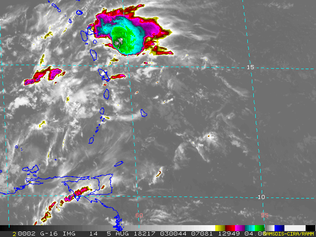
I am monitoring a cluster that formed from west of Guadeloupe and St. Lucia then passed over north Martinique and had a center for 20 minutes 75 miles east of Marie Galante.
The last SAL imagery is at 2:00 pm. yesterday and it is headed north, north-west. (No more centre). So Dominica doesn't seem to be in the picture. Too early for winds in excess of 35 mph. Waves are a normal six (06') feet.
My take: I see formation, short-lived, but formation. I think another correspondent mentioned this long-lasting TW southern islands experienced would maybe form into something.
Even more circumspect, definitely with tongue in cheek, I see between 6:00 - 8:00 o'clock am. Barbuda and to a lesser extent Antigua being on the southern side.
It sure postponed a second doze off for the night.
God Bless Attachment:
rmtcbarir42_20180805030044.gif
Description: GIF image
|
|
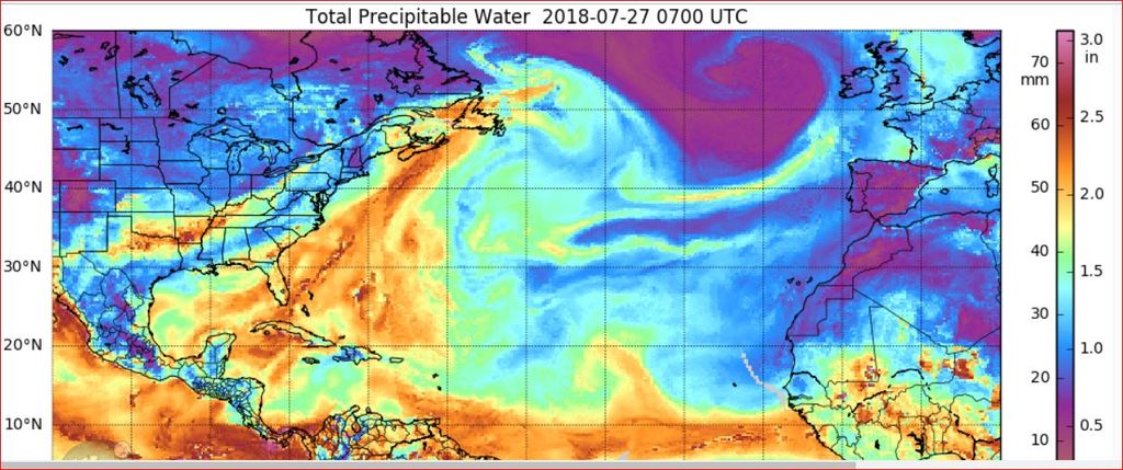
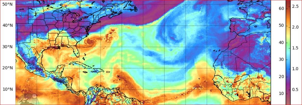
- Complacency and Throwing Caution to the Wind -
|
- By Ian Martin Borde <readkrox51 at gmail.com>
- Date: Fri, 27 Jul 2018 05:46:08 -0400
|
My Dear People of Paradise,
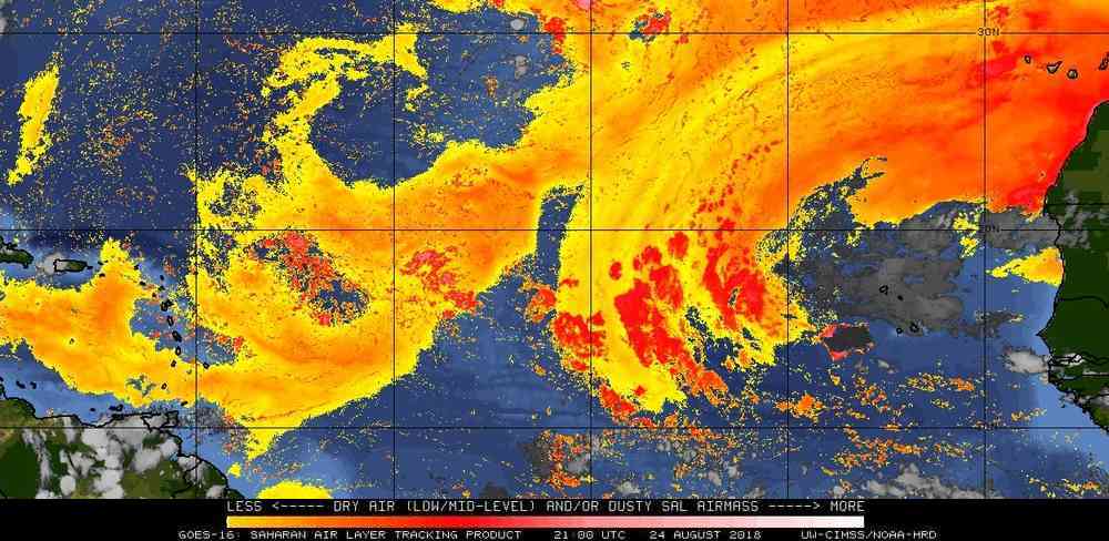
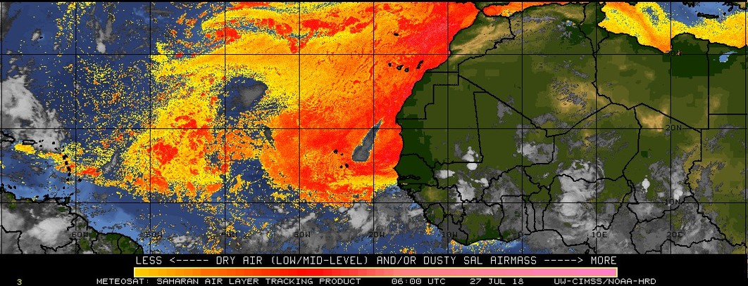
In this foreday morning, Something told me don't be complacent and check NHC's SAL image for midnight.
True-to-Form, the SAL has cleared up enough to warrant a post. For seasoned trackers when SAL is clearing up we check the generators and gas and water. Okay, Mr. Alarmist, but there is no possibility of cyclonic activity for the next three days. Ans. "Yes! But we are in the middle of a huge bunch of tropical waves!" Work on Sahara Dust - SAL - is un-understandable for the present but a 'truism' is; When it's not there, anything can happen at anytime.
To quote the correspondent from St. Croix, who I respect very much and I am glad the road is going to be finished. It was the most affected thing where she lived during last year. [" We cannot become complacent. We have to stay in a preparedness mode. May God bless us all."] Attachment:
2018-07-27th Fri 0200am.jpg
Description: JPEG image
Attachment:
2018-07-27th Fri 0300am.JPG
Description: JPEG image
|
|
- Nothing Cyclonic Threatening -
|
- By Ian Martin Borde <readkrox51 at gmail.com>
- Date: Mon, 23 Jul 2018 08:15:34 -0400
|
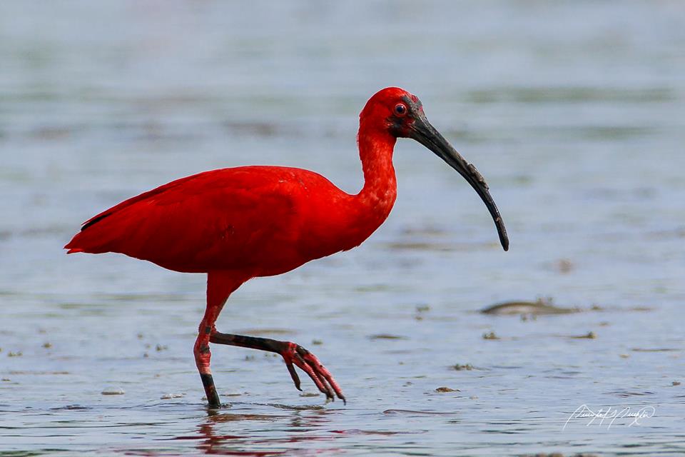
People of Paradise,
I wish that all the rain Trinidad is getting we could share with near drought stricken islands, ....
In tandem, this is probably the longest mango season I ever witnessed! I picked and gave away 'cherries' twice and the tree is giving off another crop as we write. If I sell the amount of limes on the tree, I would have $100.
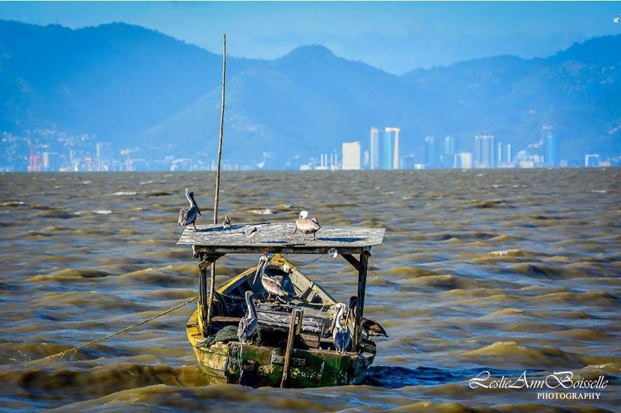
Weatherwise: From today, Trinidad and southerly islands can expect rain for the next three days. It will get heavier as the midweek arrives. (Saying that; I am hearing some strange weather forecasts for the weekend gone.)
There is something, probably cyclonic just left Africa. This however is likely to be a fish storm.
[(My) Quote:] "Survival is not paranoia, but the essence for culture."
God Bless Attachment:
1Pawi - Trinidad.jpg
Description: JPEG image
Attachment:
13626954 _ Humming Bird Nest.jpg
Description: JPEG image
Attachment:
13645127 _ Parrot Strolling.jpg
Description: JPEG image
Attachment:
13680691 _ Egret.jpg
Description: JPEG image
Attachment:
14364828 _ Scarlet Ibis.jpg
Description: JPEG image
Attachment:
20799125 _ Hummingbird.jpg
Description: JPEG image
Attachment:
Billy - Bird Watching (pcs).jpg
Description: JPEG image
Attachment:
Republic Pelican 2017 with catch.jpg
Description: JPEG image
|
|
- Lovely Day for Football -
|
- By Ian Martin Borde <readkrox51 at gmail.com>
- Date: Wed, 11 Jul 2018 06:44:56 -0400
|
Beautiful People of Paradise,
What a Lovely Day for Football !!!
[Attached:] Trinidadians could do well to keep this 'handy'.
God Bless
Peace Attachment:
IMG-20180702-WA0000.jpg
Description: JPEG image
|
|
- 'Beryl' is a Sprinter, Thank God -
|
- By Ian Martin Borde <readkrox51 at gmail.com>
- Date: Mon, 9 Jul 2018 02:22:26 -0400
|
Beryl is the second (2nd) smallest Atlantic storm. I think it is the 'quickest' one.
For what weight my opinion is worth. 1) First - Responders can operate from now in Barbados, Martinique, Dominica and Marie - Galante, with a 'Normal' Degree of Safety. Waves can reach 11' feet and the runoff from mountains will continue till just before midday. So civilians should stay put for the night.
2) Montserrat and Guadeloupe are experiencing emergency conditions still, but: a) 'Beryl' is not even a depression now. b) 'Beryl' is northwest of Guadeloupe and south of Montserrat. First-Respondents can perform well in these conditions specially if the injured and ill are cooperative.
If sleep comes now. I will embrace her.
Thank, The Almighty One
|
|
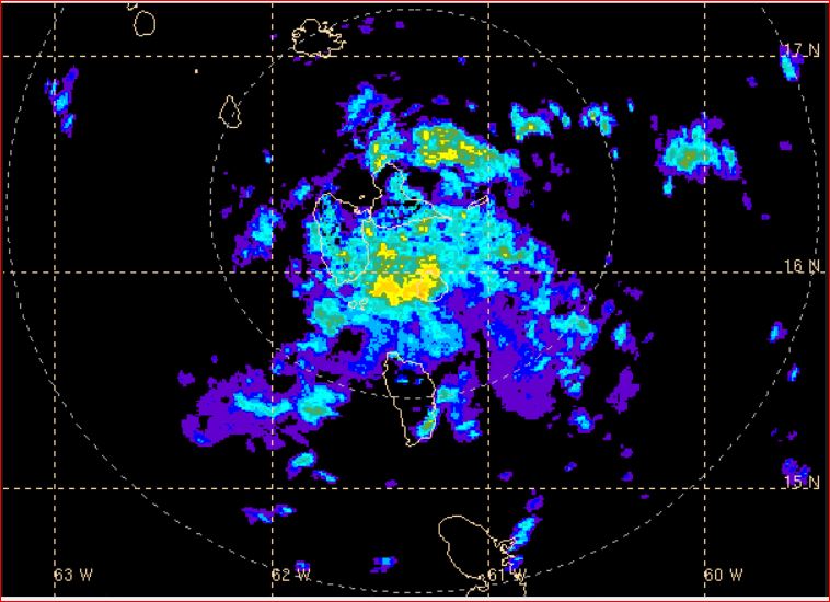
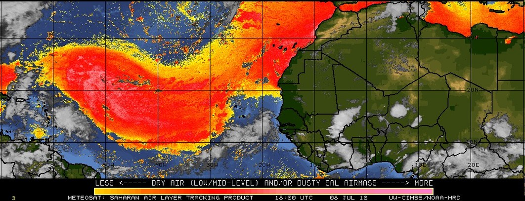
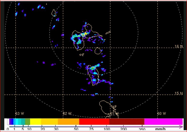
- Stay Safe -
|
- By Ian Martin Borde <readkrox51 at gmail.com>
- Date: Sun, 8 Jul 2018 21:49:00 -0400
|
S t a y S a f e
until further Notice !
At about 9:00 o'clock the defined centre seemed to be over Grande Anse and Vieux Fort heading west of Guadeloupe in 4 - 6 hours time.
Sorry to say, but Marie-Galante took the biggest beating. THE POINT IS: AND IS STILL TAKING A BEATING, ... !
The attached images of predicted and actual precipitation is 'PERILOUS' even for Emergency workers! I repeat: The tail is nothing to play with!!!!!
Stay Safe and Secure by listening to The Authorities.
Standing By Attachment:
- - Precipitation in 'Beryl's Tail - -.JPG
Description: JPEG image
Attachment:
'Beryl' Centre at 830pm Sunday 08th July 2018.JPG
Description: JPEG image
Attachment:
'Beryl' Centre at 845pm Sunday 08th July 2018.JPG
Description: JPEG image
|
|
- It's far from Over -
|
- By Ian Martin Borde <readkrox51 at gmail.com>
- Date: Sun, 8 Jul 2018 19:30:46 -0400
|
Beware of The Rain & Tail
|
|
- You are NOT Alone !
|
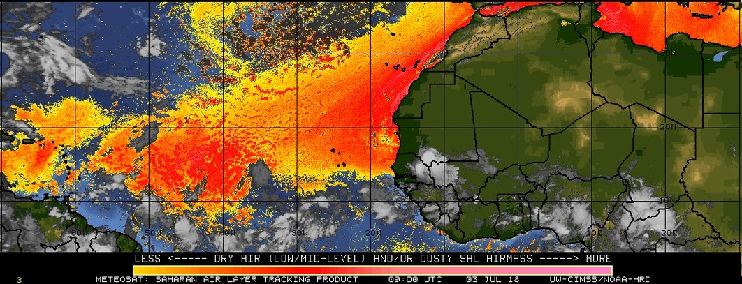
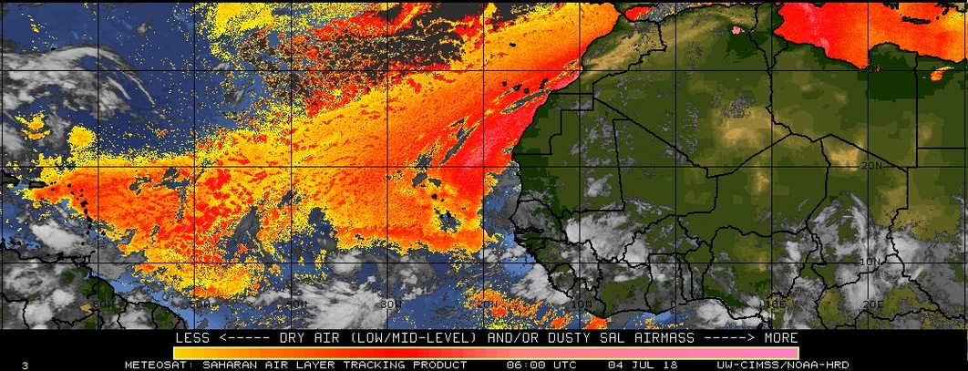
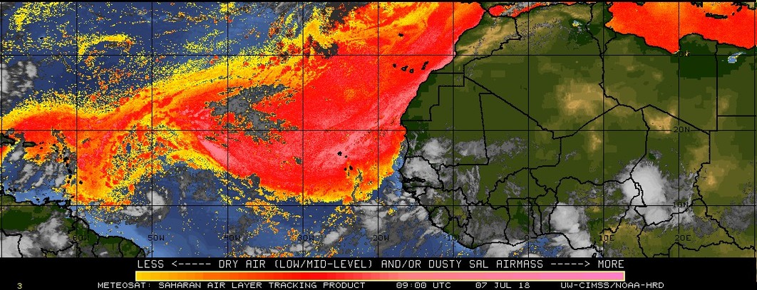
- By Ian Martin Borde <readkrox51 at gmail.com>
- Date: Sun, 8 Jul 2018 16:03:28 -0400
|
Dominica, & The People of Paradise,
You are not alone, ... !!!!!!!!
Moving on (along with Congratulatory Work already Done), ...
Expect Landfall anytime now. My take is slightly above Dominica. The heavier winds will definitely be north of Dominica.
Waves: 7' - 11' feet. Winds: 20 - 50 mph. (no uprooting but broken branches). Rain: more (may be much more) than four (04") inches over a 24 hour period.
STAY WELL AWAY FROM WATERWAYS EVEN AFTER THE STORM PASSES, ... !
The work this year is Exemplary.
God is Blessing us Now ! Attachment:
2018-07-03rd Tue 0500am.jpg
Description: JPEG image
Attachment:
2018-07-04th Wed 0200am.jpg
Description: JPEG image
Attachment:
2018-07-05th Thu 0800am.jpg
Description: JPEG image
Attachment:
2018-07-07th Sat 0500am.jpg
Description: JPEG image
Attachment:
2018-07-08 Sun 200pm.jpg
Description: JPEG image
|
|
- Pro-Active Watching, (but not waiting), .... !
|
- By Ian Martin Borde <readkrox51 at gmail.com>
- Date: Sat, 30 Jun 2018 06:49:10 -0400
|
Dear People of Paradise,
Just a heads-up to tell you the dry spell is over. We can expect rain, moderate rain, for the on-going 3-5 days.
After this there may be something to talk about. Hint: It is not a 'Reprieve'.
Reminder: Sometimes, Staying Silent is a Simple Solution, and What More, a Worthy Example, ... !
God Bless Attachment:
- Peace - Perfect Peace -.jpg
Description: JPEG image
|
|
- Timeout - Reprieve -
|
- By Ian Martin Borde <readkrox51 at gmail.com>
- Date: Sat, 23 Jun 2018 08:35:42 -0400
|
Hearty Blessings, People of Paradise,
It is joyous to say when the TW mentioned by almost all of us, passes its final stage in the Eastern Caribbean ie. Puerto Rico and The Virgin Islands. Good or Bad after - effects of this current one. There will be the semblance of a reprieve.
This post is about neither the TW or the Reprieve.
Let's give "Thanks!'
Whatever higher authority helped you this far.
Let's give, "Thanks!" Attachment:
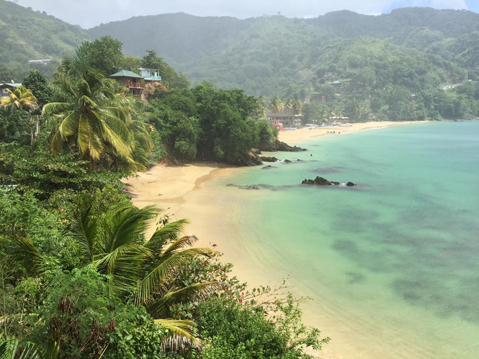
- - Manzanilla & Galeota Point - Trinidad's East Coast - -.JPG
Description: JPEG image
Attachment:
- - - - Psalm 91-4 - - - -.jpg
Description: JPEG image
|
|
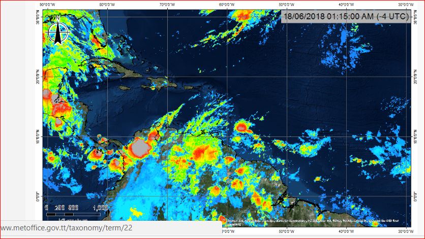
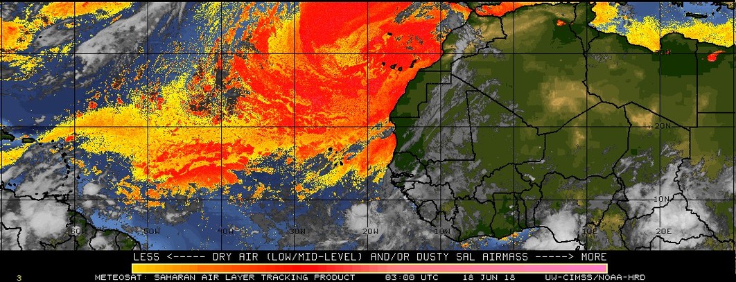
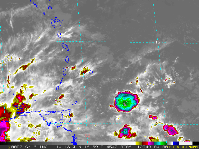
- Stand Up & Be Brave - Don't Panic -
|
- By Ian Martin Borde <readkrox51 at gmail.com>
- Date: Mon, 18 Jun 2018 03:17:07 -0400
|
People of Paradise,
Anyone 'sneezing' in our company. Is 'wind' we can do without. Sad to say. But basically and have-to-be-said is, We are still traumatized.
Please forgive me, "it is very hard to remain 'real' and true".
As per NHC:
A tropical wave will reach the waters E of the Lesser Antilles
towards the morning, then enter the eastern Caribbean through Wed
night. This system is expected to be accompanied by scattered
showers and thunderstorms. As the wave passes across the Lesser
Antilles into the eastern Caribbean, it will bring gusty winds and
a modest increase in showers and thunderstorms to the Leeward
Islands, the UK/US Virgin Islands and Puerto Rico by mid week.
Winds: 15 - 18 mph. (gusting above 20 mph.) Seas: 6' - 7' feet. (Mild, compared to the graphics) Precipitation: (Slightly) Over one (01") inch.
Nothing to worry about, Just 'bad news' at this time.
God Bless
Attachment:
- Guadeloupe Radar - Mon 18th June 2018 approx 0200 am -.JPG
Description: JPEG image
Attachment:
- T'dad Radar - Mon 18th June 2018 at 0115 am -.JPG
Description: JPEG image
Attachment:
2018-06-17th Sun 1100 pm.jpg
Description: JPEG image
Attachment:
2018-06-18 Mon 0200am.gif
Description: GIF image
Attachment:
2018-06-18th Mon 0200am.jpg
Description: JPEG image
|
|
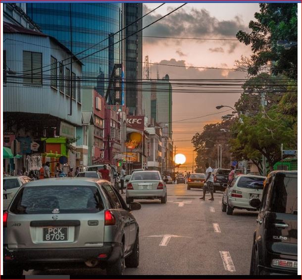
- Another Long Weekend in T&T -
|
- By Ian Martin Borde <readkrox51 at gmail.com>
- Date: Fri, 15 Jun 2018 10:29:16 -0400
|
Hi to all People of Paradise,
Just to let you know from today and the next two days.
It will be great to go to 'The Beach' or River, ... !
(People like me, who are irrational and paranoid, would find the weather 'Great' to get Survival Aides and Techniques in place with the three days weather.)
Sunny and Dry !
[There is a section of the current TW. at 45 W. trying to break away and trying to circulate in the wind-shear and SAL.] He said, sounding irrational. But definitely not in 'denial', ... !
Albert Einstein said: "You can't fix new problems with old ideas".
He said, sounding irrational.
God Bless
Attachment:
- - Maracas - -.jpg
Description: JPEG image
Attachment:
- Dusk in the city of Port of Spain -.JPG
Description: JPEG image
Attachment:
May 2018 - Shark Caught off Toco.JPG
Description: JPEG image
|
|
- 2nd June - Second TW -
|
- By Ian Martin Borde <readkrox51 at gmail.com>
- Date: Sun, 3 Jun 2018 08:25:29 -0400
|
People of Paradise,
In The Cumana/Chaguaramas Peninsula area of Trinidad the Black and Yellow ?Toucan? is in almost abundant proliferation now. He feeds and nests every afternoon at sunset just outside the gallery. The ravens haven't left. But are dwindling. (I see hawks every so often).
Our (wet season) second Blob is more distinct ( heavier & high-altitude clouds) but more southerly than the first.
Forget the Blob !!!!!!! Forget the Graphics !!!!!!! Specially as it's moving at 25 - 30 kts. due west. Address all HUMAN CONCERNS, WITH TOP, TOP, TOP, priority ! ie. Water, Medicines, Non-Perishables, Emergency shelters (Information and logistics), Communication Devices and Essential Documents (Valid!), Government and Volunteer Liaison and Input, etc, etc, etc, ... !!!
As usual I include NHC information:
A tropical wave is over the central Atlantic with axis extending
from 13N46W to 00N47W, moving westward at 25-30 kt. The wave is
depicted as a broad trough of moisture on TPW imagery. The wave is
void of convection at this time.
God Bless You
Attachment:
- 2nd June - Second TW -.JPG
Description: JPEG image
|
|
- Watchful Weekend !
|
- By Ian Martin Borde <readkrox51 at gmail.com>
- Date: Fri, 25 May 2018 04:20:21 -0400
|
Good People of Paradise,
It has been miraculously sunny in this early wet season. That is after a prolonged wet season last year. There is plenty of what I like most going on. Enlightening and mind-opening sharing of ideas and conversation. All this while steady progress is going on with the retaining wall. A charitable organization I belong to, seems to be back on its feet.
Weatherwise: Pre-'Alberto' is exiting Central America to take formation in The Gulf. My sentiments to Belize, Cayman Islands and Central America. Trinidadian Vessels using the Panama are nearby.
Same time, the first 'Distinct' eastern Caribbean (minimal) Tropical Wave will affect us. (Instead of 36 hours, let's say this weekend.) This will be Trinidad's Third Blob for the season.
All in a day's work.
Now off to Morning Meditation and Prayer! Attachment:
- - Capital City looking West - T&T - West Indies - -.JPG
Description: JPEG image
|
|
- 1st of June approaches !!!!!!!
|
- By Ian Martin Borde <readkrox51 at gmail.com>
- Date: Mon, 21 May 2018 07:00:49 -0400
|
Glencoe, Carenage, Diego Martin, T&T, W.I. 2018-05-21st Monday 06:50 am.
Friday 1st June is approaching. The beginning of 'The Wet Season'.
We have war wounds and to heal, we need to defend ourselves, ... ! Not relive the past. We need HELP, however we get it.
I will not even bother to detail the 'drill' !
Just keep on, Go on, and Do it !
(Staying humble and caring), ... Attachment:
Protective Male Bird - North Coast (pcs).jpg
Description: JPEG image
|
|
- 2nd Blob -
|
- By Ian Martin Borde <readkrox51 at gmail.com>
- Date: Tue, 8 May 2018 16:50:59 -0400
|
Hardly any birds lit up the sky today.
The reason, Picture attached, ...
Thank God for Wind Shear besides the SAL.
Almighty God Protect Us Attachment:
2018-05-08th PM - 2nd tropical wave.JPG
Description: JPEG image
|
|
- 2nd Blob of 2018 -
|
- By Ian Martin Borde <readkrox51 at gmail.com>
- Date: Tue, 8 May 2018 16:47:44 -0400
|
Hardly any birds and butterflies lit up the sky today.
The reason, |
|
- Happy 1st May / Month of May -
|
- By Ian Martin Borde <readkrox51 at gmail.com>
- Date: Tue, 1 May 2018 04:34:35 -0400
|
2018-05-01st Tuesday 04:25 a.m.
I am "Sorry!" but "Yes!" the evidence is clear. (And to a certain extent it's collaborated). When it survives SAL and 'terrible' (in this case 'good') wind-shear. A tropical wave, the first from Africa (exited Sunday) will affect the Eastern Caribbean.
It's way much too early. That anyone can predict arrival time or intensity. However waves are 8' - 9' feet in the vicinity of its influence.
I wish I could curl up with my head under a pillow next to my wife under the covers. But none of that is possible.
Enjoy the Month of May, ...
Your bro Attachment:
2018-05-01st tue - direct obstruction.jpg
Description: JPEG image
Attachment:
2018-05-01st Tue 0300am - 1st African Wave for 2018.JPG
Description: JPEG image
|
|
- The 'Wet' Season is Here -
|
- By Ian Martin Borde <readkrox51 at gmail.com>
- Date: Sun, 15 Apr 2018 03:41:30 -0400
|
Glencoe, Carenage,
Diego Martin, T&T, W.I. 2018-04-15th. Sunday 03:20 a.m. [Thought:] "Find the courage and strength within yourself. That we work selflessly as a 'Team' without early judging anyone or anything". [ref: Ian M. Borde] There we have it. The 'Reprieve' of Dry Season, barely lasted three weeks. As I am writing ITCZ rain clouds are forming over Trinidad just short of Barbados. Included in this post is a 36 hour scientific image
forecast. At the present circumstance, it is nothing to worry about. Winds; Gusting over 15 mph. Seas; over 6' feet. Precipitation; less than an inch. Wake up, because this is 'Modern Weather'. Included in the images is a forecast for Gale conditions in 36 hours for parts of the Bahamas. I really don't know how else to put this across. God Bless Attachment:
2018-04-15th Sun - 36 hr forecst.gif
Description: GIF image
Attachment:
2018-04-15th 0230am - developing LPS's.jpg
Description: JPEG image
|
|

