|
|
- - - 2018 Hurricane Season - - -
|
- February statistics and March forecast for St Maarten
|
- By Barbara Cannegieter <barcann at hotmail.com>
- Date: Thu, 7 Mar 2019 13:24:52 +0000
|
|
Good morning
Attached please find the statistics for February weather in St Maarten.
Rainfall for the month was below normal, which I guess is true for most of the Northern Caribbean.
You can also go to this link for a more detailed forecast from March to May in the March newsletter.
|
Attachment:
weather feb.pdf
Description: weather feb.pdf
|
|
- Busy St Maarten
|
- By Barbara Cannegieter <barcann at hotmail.com>
- Date: Thu, 28 Feb 2019 19:14:23 +0000
|
|
It's nice to see how our little island has bounced back since Hurricane Irma. Although there is still lots to
fix, many of the tourist attractions are open.
There are 6 cruise ships in port today and that will help the businesses in Philipsburg.
and this weekend is the annual Heineken Regatta which brings a lot of business to the island. The main days of sailing are the next three days.
Oh, did I mention that the weather is great? Sunny skies, a beautiful breeze, and comfortable temperatures. I love this time of year. The only drawback to the weather is that there is not enough rain which we do need. The hills are starting to look a little
brown.
|
|
|
- SXM MET Office February newsletter
|
- By Barbara Cannegieter <barcann at hotmail.com>
- Date: Sun, 10 Feb 2019 15:17:17 +0000
|
|
Good morning everyone
Summary of Forecast for February to April 2019
Feb-Mar-Apr, rainfall totals are expected to be the usual or drier.
Temperatures will be seasonably comfortable throughout February and begin to rise thereafter.
Drought is not expected to become a major concern in St. Maarten until the end of May 2019.
|
|
|
- St Maarten weather
|
- By Barbara Cannegieter <barcann at hotmail.com>
- Date: Tue, 22 Jan 2019 22:06:42 +0000
|
DATE ISSUED: Tuesday, January 22, 2019 at 18:00 LST (22:00 UTC)
VALID UNTIL: Wednesday evening (18:00 LST) January 23, 2019
…A SMALL CRAFT ADVISORY IS NOW EFFECT FOR ST. MAARTEN UNTIL FURTHER NOTICE…
WEATHER:
Tonight through Wednesday evening: Partly cloudy and breezy with brief local showers possible.
Forecast High: 28°C / 82°F
Forecast Low: 24°C / 75°F
Sunset Today: 6:01 P.M.
Sunrise Tomorrow: 6:47 A.M.
SURFACE WINDS:
Tonight through Wednesday evening: Easterly with a gentle to moderate breeze of 10 to 18 mph.
SYNOPSIS:
A strengthening Atlantic high-pressure ridge will gradually increase the wind field over the next few days. Meanwhile, pockets of low-level moisture drifting in the wind flow may result in cloudy periods and brief local showers.
Seas are expected to deteriorate overnight, due to a combination of Northwesterly swells and strong winds. A small craft advisory is now in effect and a high surf advisory will likely be issued Wednesday morning.
STATE OF THE SEA: Moderate to Rough
WAVES/SWELLS: 6 to 8 feet
SPECIAL FEATURE: None.
OUTLOOK through Thursday evening: Partly cloudy to cloudy and breezy with isolated showers.
FORECASTER: Connor
The next weather forecast will be issued Wednesday at 06:00 LST (10:00 UTC).
|
|
|
- January to March forecast
|
- By Barbara Cannegieter <barcann at hotmail.com>
- Date: Tue, 15 Jan 2019 19:35:36 +0000
|
|
Our Met Office has issued it's forecast for January to March 2019.
Jan-Feb-Mar, rainfall totals are expected to be lower than usual. Daytime temperatures are expected to be warmer than usual while night-time temperatures are expected to be as usual and become warmer by March. Drought is not expected
to become a major concern until the end of May 2019.
|
|
|
- still windy with rain squalls in St Maarten today
|
- By Barbara Cannegieter <barcann at hotmail.com>
- Date: Sat, 29 Dec 2018 14:19:10 +0000
|
|
Good morning
Sorry for that double posting yesterday.
Today's weather seems to be a repeat of yesterday so far. Just as the sun seems to be coming out, the wind picks up and a rain squall comes through.
Here is the forecast from our Met Office this morning:
DATE ISSUED: Saturday, December 29, 2018 at 06:00 LST (10:00 UTC)
VALID UNTIL: Sunday morning (06:00 LST) December 30, 2018
…A SMALL CRAFT WARNING REMAINS IN EFFECT FOR ST. MAARTEN UNTIL MONDAY, DECEMBER 31, 2018…
WEATHER:
Today through Sunday morning: Partly cloudy to cloudy at times and windy with isolated showers.
Forecast High: 29°C / 84°F
Forecast Low: 23°C / 73°F
Sunset Today: 5:46 P.M. Sunrise
Tomorrow: 6:43 A.M.
SURFACE WINDS:
Today through Sunday morning: East-northeast to east with a moderate to strong breeze of 14 to 30 mph, and higher gusts.
SYNOPSIS:
A strong Atlantic high-pressure ridge will continue to generate windy conditions and above normal seas across the region today. Additionally, bands of moisture from north drifting with these winds many produce occasional showers over the local area.
Seas are expected to peak near 12 feet today, particularly on the eastern shore. Sea bathers and occupants of small crafts should stay on shore to prevent personal injury, death, or material damage over the weekend.
STATE OF THE SEA: Rough
WAVES/SWELLS: 8 to 12 feet
|
|
|
- Fwd:
|
- By Barbara Cannegieter <barcann at hotmail.com>
- Date: Fri, 28 Dec 2018 14:59:56 +0000
|
|
Good morning and Happy New Year. Best wishes to you all for 2019.
As we close out 2018, we are experiencing some windy weather with occasional rain squalls blowing in.
Quite a few pots in our yard have blown over and we just had a gust of wind at the house that i am sure was at least 40 MPH.
I have the house closed up tight and I am still cold. But at least it is not snow.
Our weather service states in part the following:
SURFACE WINDS: Today through Saturday morning: East-northeast with a moderate to strong breeze of 13 to 23 mph, and higher gusts.
SYNOPSIS: A surge of low-level moisture passing the region will cause periodic cloudiness and isolated showers across the local area. Additionally, a tight pressure gradient associated with the strengthening Atlantic high pressure will cause brisk
winds and deteriorating seas, with above normal northeast to easterly swells. Rough waves are expected to peak near 11 feet on Saturday, particularly on the eastern shore. Sea bathers and occupants of small crafts are urged to stay on shore to prevent personal
injury, death, or material damage over the weekend.
|
|
- Update
|
- By Barbara Cannegieter <barcann at hotmail.com>
- Date: Fri, 28 Dec 2018 14:49:27 +0000
|
|
Good morning and Happy New Year. Best wishes to you all for 2019.
As we close out 2018, we are experiencing some windy weather with occasional rain squalls blowing in.
Quite a few pots in our yard have blown over and we just had a gust of wind at the house that i am sure was at least 40 MPH.
I have the house closed up tight and I am still cold. But at least it is not snow.
Our weather service states in part the following:
SURFACE WINDS: Today
through Saturday morning: East-northeast with a moderate to strong breeze of 13 to 23 mph, and higher gusts.
SYNOPSIS: A
surge of low-level moisture passing the region will cause periodic cloudiness and isolated showers across the local area. Additionally, a tight pressure gradient associated with the strengthening Atlantic high pressure will cause brisk winds and deteriorating
seas, with above normal northeast to easterly swells. Rough waves are expected to peak near 11 feet on Saturday, particularly on the eastern shore. Sea bathers and occupants of small crafts are urged to stay
on shore to prevent personal injury, death, or material damage over the weekend.
|
|
|
- Special Weather Bulletin Met Office St Maarten
|
- By Barbara Cannegieter <barcann at hotmail.com>
- Date: Mon, 12 Nov 2018 20:45:19 +0000
|
SPECIAL WEATHER BULLETIN #1
DATE ISSUED: Monday, November 12, 2018
TIME ISSUED: 04:00PM
VALID UNTIL: Thursday, November 14, 2018
_____________________________________
…A HEAVY RAINFALL ADVISORY IS IN EFFECT FOR ST. MAARTEN…
Abundant moisture and instability associated with an approaching active tropical wave (invest 96L) will produce unstable weather conditions across the region from Early Tuesday November 13th through Thursday November 15th 2018.
As the system approaches the area, there is an increased possibility for showers and thunderstorms accompanied by gusty winds over the local area. Some of these showers may be heavy and will lead to localized flooding over sections of the island.
Residents in low-lying areas should be vigilant and take the necessary precautions as soils are already saturated. Motorists should avoid driving on flooded streets until the heavy rainfall has tapered off or ended and the floodwaters have receded.
In case there are lightning strikes very close to your location (loud thunder, less than three seconds between lightning discharge and thunder), switch off and disconnect any sensitive electronic equipment. Also, disconnect any phone line from your computer.
Meteorological Department St. Maarten will continue to monitor the situation and keep the public informed through special bulletins.
The next update will be issued at 6:00 am Tuesday November 13th 2018.
|
|
|
- Update
|
- By Barbara Cannegieter <barcann at hotmail.com>
- Date: Mon, 12 Nov 2018 21:58:29 +0000
|
For Immediate Release: Monday, November 12, 2018/N194
Motorists advised in the event of heavy rainfall drive with extreme caution or stay-off road network
GREAT BAY, Sint Maarten (DCOMM) – The Fire Department is requesting motorists to drive with extreme caution during heavy rainfall or if possible, to stay-off the road network as such events cause severe street flooding.
On Monday afternoon the Meteorological Department of Sint Maarten (MDS) issued a heavy rainfall advisory. The advisory was issued due to an abundant moisture and instability associated with an approaching active tropical wave. This wave according to MDS will:
produce unstable weather conditions across the region from early Tuesday November 13th through Thursday November 15th, 2018.
The MDS says, as the system approaches the area, there is an increased possibility for showers and thunderstorms accompanied by gusty winds over the local area. Some of these showers may be heavy and will lead to localized flooding over sections of the island.
MDS advises residents in low-lying areas should be vigilant and take the necessary precautions as soils are already saturated. Motorists should avoid driving on flooded streets until the heavy rainfall has tapered off or ended and the floodwaters have receded.
MDS adds, in case there are lightning strikes very close to your location (loud thunder, less than three seconds between lightning discharge and thunder), switch off and disconnect any sensitive electronic equipment. Also, disconnect any phone line from your
computer.
MDS will continue to monitor the situation and keep the public informed through special bulletins. MDS weather reports and bulletins are available by visiting its website: www.meteosxm.com
The Fire Department advises for those already out and a heavy rainfall event takes place, motorists should avoid driving in low lying areas which have become inundated.
Those driving along hill-side roads should drive with caution and be on alert for possible rock slides.
The Fire Department reiterates for those considering going out, it is advised to stay off the road network until weather conditions improve.
Please take note that it will take a couple of hours before street flooding subsides as inundated waterways and drains slowly clear during a heavy rainfall event.
|
|
|
- Re: Special Weather Bulletin Met Office St Maarten
|
- By Barbara Cannegieter <barcann at hotmail.com>
- Date: Mon, 12 Nov 2018 21:56:28 +0000
|
|
From: Barbara Cannegieter <barcann at hotmail.com>
Sent: Monday, November 12, 2018 4:45 PM
To: storm reports
Subject: Special Weather Bulletin Met Office St Maarten
SPECIAL WEATHER BULLETIN #1
DATE ISSUED: Monday, November 12, 2018
TIME ISSUED: 04:00PM
VALID UNTIL: Thursday, November 14, 2018
_____________________________________
…A HEAVY RAINFALL ADVISORY IS IN EFFECT FOR ST. MAARTEN…
Abundant moisture and instability associated with an approaching active tropical wave (invest 96L) will produce unstable weather conditions across the region from Early Tuesday November 13th through Thursday November 15th 2018.
As the system approaches the area, there is an increased possibility for showers and thunderstorms accompanied by gusty winds over the local area. Some of these showers may be heavy and will lead to localized flooding over sections of the island.
Residents in low-lying areas should be vigilant and take the necessary precautions as soils are already saturated. Motorists should avoid driving on flooded streets until the heavy rainfall has tapered off or ended and the floodwaters have receded.
In case there are lightning strikes very close to your location (loud thunder, less than three seconds between lightning discharge and thunder), switch off and disconnect any sensitive electronic equipment. Also, disconnect any phone line from your computer.
Meteorological Department St. Maarten will continue to monitor the situation and keep the public informed through special bulletins.
The next update will be issued at 6:00 am Tuesday November 13th 2018.
|
|
|
- Invest 96L
|
- By Barbara Cannegieter <barcann at hotmail.com>
- Date: Sun, 11 Nov 2018 19:37:26 +0000
|
|
More rain may be headed our way.
96L will soon be in our neighborhood
Crown Weather says:
..the big question
is will Invest 96-L move right across the northern Caribbean islands or will it move just north of the islands. Analysis of upper level winds show that it is going to be a really close call between a track just north of the islands and a track right across
the northern Caribbean islands.
Either way, this tropical disturbance will likely bring heavy rainfall with gusty winds and rough seas beginning
across the Leeward Islands on Monday that continues into Tuesday. This squally weather is expected to spread across the Virgin Islands and Puerto Rico by Tuesday and then across Hispaniola on Tuesday night and Wednesday.
|

|
|
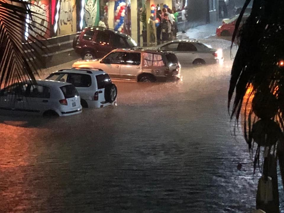
- Last night's rains in St Maarten
|
- By Barbara Cannegieter <barcann at hotmail.com>
- Date: Sun, 11 Nov 2018 13:50:01 +0000
|
|
Wow, St Maarten got bombarded last night with heavy rains. There was really no warning issued either.
I think the rains caught everyone by surprised. Even MeteoFrance which had us on yellow alert for days had put the Northern island back on regular status.
So we thought all the rain was going more south of us.
Boom! about 6:30 PM the rain started to fall heavy and it didn't let up for more than 3 hours.
Roads were quickly flooded out.
This warning was then issued via Facebook:
"The Fire Department advises motorists to remain off the road due to severe street flooding. Motorists
already on the road should avoid driving in low lying areas. Those
driving on hillside roads
should drive with caution and be on alert for possible rock slides. For
those considering going out, it is advised to stay off the road until weather
conditions improve. It will take a couple of hours before street flooding subsides as the water flows from streets
into drains and other waterways."
That was too little too late as many were on the road
already. and
nothing from our Met Office.
We were out for dinner but not far from our home
thankfully.
A friend posted this picture of early flooding. (see attachment)
My garden
rain gauge which was empty when I left home measured 5 inches of water when I
came back
home 4 hours later.
I know there are several other island which have had flooding recently.
Be careful out there! You never know what will happen with these weather patterns we have been having lately.
|
|
|
- St Maarten Met Office newletter
|
- By Barbara Cannegieter <barcann at hotmail.com>
- Date: Mon, 5 Nov 2018 20:48:39 +0000
|
|
If you click on the link, you can find the October newsletter from our Met Office here in St Maarten.
Thankfully no hurricanes to report.
|
|
|
- too much rain
|
- By Barbara Cannegieter <barcann at hotmail.com>
- Date: Sat, 13 Oct 2018 21:06:39 +0000
|
Since I posted earlier today, we have had nothing but rain, rain, rain.
A very heavy thunderstorm caused flooding on the roads and a small landslide.


An announcement from government advises to stay off the roads.
PHILIPSBURG – Minister of Public Housing, Spatial Planning, Environment and Infrastructure (VROMI), Miklos Giterson, has taken note of the heavy rainfall being experienced today, Saturday, and would like to assure residents that the Department of Infrastructure
Management is at the moment busy assessing and resolving issues caused by the heavy rainfall.
Residents are urged to stay off the roadways for the rest of the day unless travel is necessary as all roads have the possibility of experiencing temporary flooding.
|
|
|
- Update
|
- By Barbara Cannegieter <barcann at hotmail.com>
- Date: Sat, 13 Oct 2018 13:36:46 +0000
|
|
Good Morning
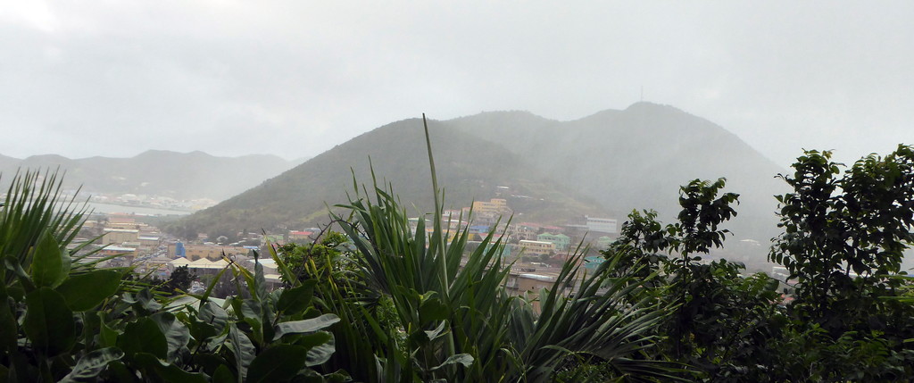
It's been a rainy night on St Maarten. This morning is cloudy and I know rain is still in the area.
Meteo France, the weather service from Martinique and Guadeloupe still has us in Yellow, a slightly elevated risk for heavy storms.
We are the bgiger island in yellow in the top left picture. The other one is St Barth's.
I am grateful for the rain. The island looks so green and beautiful. I know though there are people still living under tarps and that this rainy weather is not a comfortable situation for them.
and then there are the mosquitoes, who love this rain.
Have a a nice day, everyone!
|
|
|
- St Maarten Met Office newsletter
|
- By Barbara Cannegieter <barcann at hotmail.com>
- Date: Thu, 4 Oct 2018 21:20:20 +0000
|
|
The St Maarten Met Office has released an October newsletter with a seasonal outlook from October to December 2018.
Summary of Forecast for the season
October to December 2018.
1. Rainfall totals are expected to be lower than usual.
2. Both daytime and night-time temperatures are expected to be warmer than usual however, temperatures will get more comfortable from November.
3. Thermal stress expected to accumulate on corals by the end of October but not expected to reach bleaching levels.
The entire newsletter with forecasts can be found here:
|
|
|
- Update
|
- By Barbara Cannegieter <barcann at hotmail.com>
- Date: Sat, 29 Sep 2018 20:23:33 +0000
|
Good Afternoon from St Maarten, where all is well weather wise, but our dump is burning again.
I have no words left. The smoke is affecting the entire island. It’s difficult to breathe.
People are so frustrated and angry.
I and some others took the government to court. The case was heard Thursday. The Judge wants government to submit a road map plan of how they are going to fix this. He said he will be supervising their plans of action and if they are fulfilling
it.
We shall see.

|
|
|
- Isaac
|
- By Barbara Cannegieter <barcann at hotmail.com>
- Date: Fri, 14 Sep 2018 16:43:42 +0000
|
|
Good afternoon
Yesterday on St Maarten schools were closed and businesses closed early, just in case Isaac caused us any problems. All we had was a windy day. Skies for the most part were blue all day.
Today, after Isaac has passed us, the wind has died down, but we are having a rainy day.
We are grateful Isaac spared all of the Caribbean islands.
I am watching what is happening in the USA with Hurricane Florence, and I am reminded of last year at this time when we were experiencing the immediate aftermath of Irma.
|
|
- Update
|
- By Barbara Cannegieter <barcann at hotmail.com>
- Date: Tue, 11 Sep 2018 02:04:56 +0000
|
|
St Maarten is taking no chances with Isaac.
Three shelters to open Wednesday. Other emergency procedures are being put in place also.
|
|
- Update
|
- By Barbara Cannegieter <barcann at hotmail.com>
- Date: Mon, 10 Sep 2018 12:53:01 +0000
|
|
Good morning Caribbean friends.
I know we are all following the progress of Isaac this morning. So many of us are still recovering from last year's storms.
Currently it looks like Isaac will pass south of St Maarten, but what does that mean for the islands to the south of us?
I hope everyone will be safe. Please take proper precautions no matter where you are.
In the meantime on St Maarten, since there is NO wind. The sea is like glass. I guess Isaac is sucking up all the energy for miles around.
So, with no wind, the smoke from our Mount Dump and Mount irma, is just hanging over Philipsburg. It's ridiculous!
|
|
|
- TD 9
|
- By Barbara Cannegieter <barcann at hotmail.com>
- Date: Sat, 8 Sep 2018 15:51:05 +0000
|
Tropical
Depression #9:
5 am EDT/4 am CDT Statistics:
Location: 14.3 North Latitude, 35.4 West Longitude or about 1720 miles to the east of the Windward Islands.
Maximum Winds: 35 mph.
Minimum Central Pressure: 1007 Millibars or 29.74 Inches.
Forward Movement: West-Northwest at a forward speed of 5 mph.
The forecast for Tropical Depression #9 is a very uncertain one and all interests in the Lesser Antilles should closely monitor the progress of this
system.
Satellite imagery and weather analysis indicates that TD 9 is being impacted by fairly robust wind shear and these unfavorable environmental conditions
may continue for at least a few days. Should this occur, then the depression will struggle to strengthen and we may have a much weaker system moving into the Caribbean. This is what the latest European model and GFS model seems to suggest.
On the other hand, analysis reveals that there is an area of lower wind shear situated between 50 and 60 West Longitude and this system is likely
to move through this region by about Wednesday. What may happen is that we could see a quick burst of intensification just before TD 9 moves across the Lesser Antilles late next week and this is something that will need to be monitored.
The intensity guidance is of no help with some members peaking this at a tropical storm while a equal number of members forecast a peak intensity
of a Category 1 hurricane. The HWRF model's forecast of a Category 4 hurricane looks like a outlier and will be disregarded.
Tropical Depression 9 should move on a general west to west-northwest path for the next several days as a upper level ridge of high pressure pushes
the system westward.
My Thinking Is That this
system will end up tracking right across the southern Leeward Islands and northern Windward Islands on Thursday as a tropical storm.
The islands that really need to keep an eye on this storm include Antigua, Guadeloupe, Dominica and Martinique. It should be noted that even though I'm currently forecasting this system to move across the
central Lesser Antilles as a tropical storm, there is the very real possibility that it could be a Category 1 or 2 hurricane at that time.
Bottom line is that I strongly
advise everyone in the southern Leeward Islands and the northern Windward Islands to closely monitor the progress of Tropical Depression #9.
|
|
|
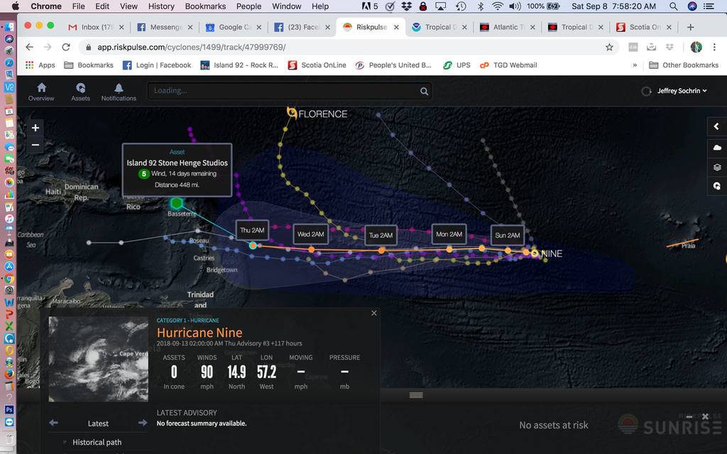
- from our local radio Island 92 Facebook post
|
- By Barbara Cannegieter <barcann at hotmail.com>
- Date: Sat, 8 Sep 2018 13:10:25 +0000
|
ROM THE ISLAND 92 WEATHER CENTER
THE GREEN DOT REPRESENTS THE ISLAND92/Z105.1 FM STONE HENGE STUDIOS IN COLE BAY, ST. MAARTEN.
NOW IS THE TIME TO BE ALERT AND MONITOR THE PROGRESS OF BOTH TROPICAL DEPRESSION NINE (POSSIBLY ISSAC IN THE FUTURE) AND TROPICAL STORM HELENE. NEITHER STORM REPRESENT AN
IMMEDIATE THREAT TO ST MAARTEN, BUT NOW IS THE TIME TO BE ALERT.
===
DEPRESSION EXPECTED TO BECOME A TROPICAL STORM LATER TODAY OVER THE EASTERN TROPICAL ATLANTIC...
SEE FIRST PICTURE. ON THURSDAY, SEPTEMBER 13 AT 2AM TROPICAL DEPRESSION NINE IS FORECASTED TO BE 448 MILES SOUTH EAST OF ST. MAARTEN.
SUMMARY OF 500 AM AST...0900 UTC...INFORMATION
----------------------------------------------
LOCATION...14.3N 35.4W
ABOUT 1720 MI...2765 KM E OF THE WINDWARD ISLANDS
MAXIMUM SUSTAINED WINDS...35 MPH...55 KM/H
PRESENT MOVEMENT...WNW OR 300 DEGREES AT 5 MPH...7 KM/H
MINIMUM CENTRAL PRESSURE...1007 MB...29.74 INCHES
WATCHES AND WARNINGS
--------------------
There are no coastal watches or warnings in effect.
DISCUSSION AND OUTLOOK
----------------------
At 500 AM AST (0900 UTC), the center of Tropical Depression Nine was located near latitude 14.3 North, longitude 35.4 West. The depression is moving toward the west-northwest near 5 mph (7 km/h). A turn toward the west is expected later today, and that general
motion at a slightly faster forward speed is forecast to continue through the weekend and into early next week.
Maximum sustained winds are near 35 mph (55 km/h) with higher gusts. Gradual strengthening is forecast during the next few days, and the depression is expected to become a tropical storm later today and a hurricane by early next week.
The estimated minimum central pressure is 1007 mb (29.74 inches).
HAZARDS AFFECTING LAND
----------------------
None.
NEXT ADVISORY
-------------
Next complete advisory at 1100 AM AST.
====
TROPICAL STORM HELENE - SEE SECOND PICTURE
SUMMARY OF 800 AM AST...1200 UTC...INFORMATION
----------------------------------------------
LOCATION...13.6N 20.2W
ABOUT 290 MI...465 KM ESE OF THE SOUTHERNMOST CABO VERDE ISLANDS
MAXIMUM SUSTAINED WINDS...45 MPH...75 KM/H
PRESENT MOVEMENT...W OR 275 DEGREES AT 13 MPH...20 KM/H
MINIMUM CENTRAL PRESSURE...1001 MB...29.56 INCHES
===
|
Attachment:
island92.jpg
Description: island92.jpg
|
|
- Invest 92-L
|
- By Barbara Cannegieter <barcann at hotmail.com>
- Date: Tue, 4 Sep 2018 16:43:37 +0000
|
From Crown Weather:
Invest 92-L Located Over The Eastern Atlantic: Invest 92-L, which is a tropical wave located to the south-southeast of the Cape Verde Islands, is likely to become our next named tropical storm by this weekend as the environmental conditions
look at least somewhat favorable for development. Invest 92-L is expected to move on a west to west-northwest path in the coming days as a ridge of high pressure will be positioned to its north.
Beyond this weekend, the question becomes how big of a threat does this system pose to the Lesser Antilles. The overall model guidance is not of much help as the GFS model has been inconsistent wavering from a definite threat to the eastern
Caribbean to a track that takes this system well north and east of the Caribbean. The European and UKMET model guidance, on the other hand, signal a threat to the Lesser Antilles in about 10 days from now.
At this point, Invest 92-L is just a system to keep an eye on for now as we are more than a week out from it even threatening the Lesser Antilles. It is quite possible that Invest 92-L may be yanked northward into the open Atlantic by a
upper level trough of low pressure left behind by Florence. It is also just as possible that the upper level trough may not be strong enough and thus Invest 92-L is guided westward towards the Caribbean during next week. Either way, it is a system to keep
an eye on for now.
|
|
|
- Update
|
- By Barbara Cannegieter <barcann at hotmail.com>
- Date: Fri, 31 Aug 2018 00:56:01 +0000
|
Good evening
It’s been a rainy day in St Maarten. I am loving the weather. The rain is most welcome as everything was pretty dry here, but the thunder and lightning last night made everyone nervous.
We all have a touch of PTSD after Irma, and now we see the tropics are seriously heating up.
Tis the season!
We must all be vigilant right now.
|
|
|
- Update
|
- By Barbara Cannegieter <barcann at hotmail.com>
- Date: Mon, 9 Jul 2018 13:11:49 +0000
|
good morning
reporting in from St Maarten. The remnants of Beryl are passing well south of us but we do have a rainy windy day. Actually we are grateful for the rain. We need it badly. and so far the rain is coming in short bursts, so there is no flooding
thankfully.
I do hope people still living under tarps are OK. They probably at the very least are damp and uncomfortable.
|
|
|
- Hurricane Beryl
|
- By Barbara Cannegieter <barcann at hotmail.com>
- Date: Fri, 6 Jul 2018 15:05:12 +0000
|
Beryl is now a hurricane, forecast to pass well south of St Maarten.
Meteo des Cyclones page on Facebook says this:
"Planned trajectory of hurricane Beryl at 05 local hours
The first hurricane of season 2018 should continue to strengthen for the next 36-48 hours before weakening at Tropical Storm Stadium Sunday morning. Beryl would be less
than 500 kilometres from martinique and a passage between Dominica and the archipelago of guadeloupe at the low tropical storm stage should occur Sunday night at Monday morning. Once in the Caribbean Sea, where the atmosphere would be more hostile, the cyclone
should become a tropical wave during the day."
I am hoping that Dominica stays safe. They certainly don't need another storm this yer.
|
|
|
- Tropical Storm Beryl 5:00 PM update
|
- By Barbara Cannegieter <barcann at hotmail.com>
- Date: Thu, 5 Jul 2018 21:36:29 +0000
|
Tropical Storm Beryl Discussion Number 2
NWS National Hurricane Center Miami FL AL022018
500 PM AST Thu Jul 05 2018
Beryl has been a bit of a surprise today, which is not uncommon for
tiny tropical cyclones such as itself. A 1724 UTC SSMI microwave
pass and a 1853 UTC SSMI/S pass both revealed that the cyclone had
developed a well-defined 5 nmi-wide mid-level eye, and a dimple has
been apparent in visible satellite imagery. It's usually difficult
to get a good handle on the intensity of these types of cyclones
given their small size, but data-T numbers from TAFB and SAB are a
consensus T3.0. The initial intensity is therefore raised to 45 kt,
but there is a lot of uncertainty in this estimate.
If the initial intensity is uncertain, the future intensity is even
more of a quandary. Despite being surrounded by abundant dry air,
Beryl has apparently been able to isolate itself and possibly
moisten the near-storm environment while located in an area of low
shear. Since the shear is expected to remain quite low for the next
36 hours or so, and small cyclones like Beryl often have a tendency
to strengthen quickly over a short period of time, continued
intensification appears likely for the next day or so. The updated
NHC intensity forecast most closely follows the statistical-
dynamical guidance, which lies at the upper end of the guidance
envelope, and brings Beryl to hurricane strength within 36 hours.
After that time, increasing westerly shear, partially due to Beryl
accelerating toward the west, is expected to cause weakening. In
addition, every global model shows the cyclone opening up into a
tropical wave in 72-96 hours, which is what the NHC forecast
continues to depict. It cannot be stressed enough, however, that
this is a low confidence forecast.
The one stable part of the forecast is Beryl's future track. The
new guidance has not changed much from the previous forecast cycle,
and it continues to show Beryl slowing down a bit during the next 24
hours, followed by a west-northwestward acceleration in 48-72 hours
due to a strengthening ridge to the north. The updated NHC track
forecast is just a bit south of the previous one and is closest to
the HCCA and Florida State Superensemble guidance.
Even though Beryl is expected to dissipate just east of the Lesser
Antilles early next week, the remnant tropical wave will continue
moving quickly westward and will likely bring locally heavy
rains and gusty winds to portions of the Leeward Islands on Sunday
and Monday.
Key Messages:
1. Due to its very small size, there is greater-than-usual
uncertainty in the analysis of Beryl's current intensity.
Confidence in the official intensity forecast is also much lower
than normal. Rapid changes in intensity, both up and down, that are
difficult to predict are possible during the next couple of days.
2. While Beryl is still expected to dissipate as a tropical cyclone
by Monday before reaching the Lesser Antilles, there will likely
be some rain and wind impacts on those islands early next week.
Residents there should monitor products from their local weather
office for more information.
FORECAST POSITIONS AND MAX WINDS
INIT 05/2100Z 10.3N 42.8W 45 KT 50 MPH
12H 06/0600Z 10.8N 44.5W 55 KT 65 MPH
24H 06/1800Z 11.4N 46.3W 60 KT 70 MPH
36H 07/0600Z 12.1N 48.3W 65 KT 75 MPH
48H 07/1800Z 13.0N 51.0W 60 KT 70 MPH
72H 08/1800Z 14.5N 58.4W 50 KT 60 MPH
96H 09/1800Z...DISSIPATED
|
|
|
- Watching 95L
|
- By Barbara Cannegieter <barcann at hotmail.com>
- Date: Wed, 4 Jul 2018 21:23:40 +0000
|
Hoping we get some rain but not anything more serious.
5:00 PM NHC update says this:
Satellite imagery indicates that shower activity associated with a
small area of low pressure and a tropical wave located several
hundred miles west-southwest of the Cabo Verde Islands has become
better organized during the past few hours. Some additional
development of this system is possible, and a tropical depression
could form during the next day or two while it moves westward to
west-northwestward at 15 to 20 mph over the tropical Atlantic
Ocean. By the weekend, upper-level winds are expected to become less
conducive for development when the system approaches the Lesser
Antilles.
* Formation chance through 48 hours...medium...50 percent.
* Formation chance through 5 days...medium...50 percent.
|
|
|
- Update
|
- By Barbara Cannegieter <barcann at hotmail.com>
- Date: Sat, 23 Jun 2018 16:59:51 +0000
|
Hello everyone
St Maarten had cloudy skies but not much rain from that tropical wave. We still need rain badly. The hills are brown and the cisterns are empty.
But our African Tulip tree, which is barely standing after Hurricane Irma, just produced its first bloom in a long time.

|
|
|
- Update
|
- By Barbara Cannegieter <barcann at hotmail.com>
- Date: Tue, 12 Jun 2018 12:15:11 +0000
|
Good morning
St Maarten continues to be dry and hot! Thankfully there is a light breeze. We need rain though.
Usually when I look out to the east and see "smoky" skies, I think it is our dump on fire again. But this morning it is Saharan dust.
Either way, my allergies are acting up.
Our weather report says in part:
Special Weather
* Dust/Allergy >> A plume of Saharan Dust is still invading the local region. Thus, allergy
sufferers are advised to take the necessary precautions until further notice.

|
|
|
- Update
|
- By Barbara Cannegieter <barcann at hotmail.com>
- Date: Sat, 2 Jun 2018 13:10:37 +0000
|
Good morning
I woke up to hazy skies on St Maarten this morning. I thought our dump was on fire again, but, no, I don't think that's it, for a change.
I think we are getting some Saharan dust today, and it looks like more coming across the Atlantic.

|
|
|
- Update
|
- By Barbara Cannegieter <barcann at hotmail.com>
- Date: Sun, 27 May 2018 12:51:11 +0000
|
Good morning
Skies are partially cloudy over St Maarten this morning. Our Met Office says
"Moisture and instability associated with a tropical wave will account for cloudiness and isolated showers, some of which may be heavy across the local area."
We need some
rain so I do hope we get some showers.
Sub Tropical
storm Alberto is producing lots of rain over Florida this
morning.
Reminder to everyone that
even a weak
tropical wave can
produce flooding, especially in the islands.
|
|
|
- Update
|
- By Barbara Cannegieter <barcann at hotmail.com>
- Date: Tue, 22 May 2018 22:08:18 +0000
|
Hello Caribbean friends
It's been awhile since I have posted. We have been busy with fixing things up since Irma. The island is getting better but we still have a long way to go.
I can't believe a new hurricane season is almost upon us. I hope that we are all are safe from any storms this year.
Right now the weather is getting hot again, but we still have a delightful cool breeze. We are having a few showers but we still need some rain, just not too much.
As a result of Irma, the St Maarten Zoo, where I volunteered for many years, is permanently closed. Many of the animals were rescued and many were sent to the Curacao Zoo.
However, I inherited Anna. She is a fabulous bird, but very noisy. She sure keeps me busy.

|
|
|


