|
|
- - - 2017 Hurricane Season - - -
|
- Dominica
|
- By Lisette Stevens <jaco.lass at gmail.com>
- Date: Fri, 23 Mar 2018 11:40:40 -0400
|
It has been a while since I have posted! Dominica is looking much greener now, nature has a wonderful way of fixing itself. The island still has a long way to go and we feel that the summer here is going to be extremely hot as we do not have the forest cover and shade from the trees.
The hurricane season is approaching far too quickly for our liking. Many homes need to be fixed. Listening to everyone it seems difficult to get materials as so many islands were affected by Irma and Maria. In the Layou valley we are seeing quite a lot of parrots which is wonderful. However we are not seeing many hummingbirds or banana-quits, it is very tragic. We still have no electricity in our area and we think it will be a long time before we get it. We are so lucky to have a generator. Mainly our internet is on our smartphones. Wifi is in Roseau and Portsmouth! There are many areas without electricity and internet. It is not an easy time in our islands and the folks who were always excited about experiencing a hurricane might have changed their minds now!! None of us here are looking forward to 2018 hurricane season.
|
|
- Dominica
|
- By Lisette Stevens <jaco.lass at gmail.com>
- Date: Fri, 16 Feb 2018 12:20:48 -0400
|
Hi everyone!! Long time no hear?? Jaco Ladd and I apologize!
We are still very much in Dominica. Dominica is becoming green again although, the trees are standing up now like soldiers ripped of their branches. Standing their ground sprouting bits of leaves on their trunks, it is strange to the eye. The beautiful cover of the trees is to a certain extent gone but nature is wonderful and we are not called the nature island for nothing! We are having very odd weather though! for the last 6 weeks the weather pattern has been very high winds with heavy showers. This weather has been happening every night and most days it is as if the weather has been programmed! Usually at this time of the year it is the dry season. This continual rain and heavy showers at night is extremely upsetting especially for the many people who do not have a roof and have tarpaulins. Many houses have still to be repaired from hurricane Marie. There has been a lack of materials on the island because of so many other islands being damaged by Irma and Maria. The 2017 hurricane season was very unkind. It is daunting to think that 2018 is predicted to be worse, we here in Dominica sincerely hope not.......................... Dominica has just had Carnival last weekend and it did moral a lot of good. People were able to party and take their minds off the every day struggle of living with no electricity. The island has many places without electricity power and our telephone system is very lacking, both Flow and Digicel are having communication problems throughout the island. Our internet where we live for data on our phone is worse now than just after the hurricane. This is one of the reasons you have not heard from us. We are in Roseau today on proper internet. We feel for other folk in the other islands, we are all trying to rebuild and look after each other. 3 more months and we are back on watch mode for the hurricane season will be upon us............................... |
|
- Sunny & Beautiful skies...
|
- By Micheal Colaire <nichs2002 at yahoo.com>
- Date: Fri, 15 Dec 2017 23:21:07 +0000 (UTC)
|
|
Thankfully, weather conditions over the last few days have continued to be quite nice & Sunny. Also, night time temperatures have not been too cool as the Christmas season advances with beautiful clear skies. And Inspite of the Impacts from Maria, much of the Christmas spirit on island is still very alive and well in the Nature Isle, Dominica, Praise be to Jesus! & While the bamboo bursting this year will be limited due to vegetation damage caused by Maria, the other holiday firecrackers are in good supply.
By now most of our diligent Regional Security Services members whose great service was mentioned by other correspondents have left. And with the Capital city curfew long since gone, things are certainly getting back to normal more rapidly than ever before. Again many thanks to all our regional & international partners who have continued to support our relief & recovery efforts in the most severely affected areas as well as our re-building phase which has commenced. We encourage all those who are able to significantly Contribute to this critical re-construction process to do so generously.
Wishing Everyone a Very Blessed & Merry Caribbean Christmas season- free from All storms & Bad weather. |
|
- Hurricane Season Goodbye
|
- By Lisette Stevens <jaco.lass at gmail.com>
- Date: Wed, 6 Dec 2017 11:13:21 -0400
|
No one in Dominica will forget 2017 and hurricane Maria!
The good news is that leaves are coming on the trees, the grass is growing, the parrots have survived and are coming back to the valley!
Roseau is alive again with traffic and lots of folks dressed in colourful clothes chatting and laughing too. It is so lovely to walk in the streets and get the feeling of normalcy. So many people have suffered so much and I think everyone here is amazing! People are helping each other and it is great to see what is going on and to know that everyone is trying their best to be happy. Many folks around the island do not have electricity and running water. I think it will take a while; the predicted date for the island to have whole restoration for electricty is the end of April 2018.
We are lucky as we have a generator and our own water supply!
Christmas is coming and hopefully Christmas cheer too. |
|
- Gorgeous Weather until...
|
- By conanshillingford4 <conanshillingford4 at gmail.com>
- Date: Sat, 02 Dec 2017 00:39:34 -0400
|
|
Thankfully we have been having pretty Gorgeous weather conditions in the Nature Isle, with the odd sprinkle mixed in to keep our re-greening process coming on strong in the aftermath of Super destructive Category Five Hurricane Maria. Also, recovery works Re:- utilities continue to progress albeit slower than anticipated at this point. Additional power utility crews are a must for the island.
Weather-wise, However, today was certainly unlike most other days- bringing much more rainy & overcast skies, but overall not too heavy, which is crucially important given the fragility of the ecosystem after the ravages of Catastrophic Hurricane Maria. The Lord has truly been kind to our island in the wake of such an historic Super hurricane- from truly rapid intensification.
Thus, we give continued Thanks & Praise to God for His Daily Tender Mercies & Graces; not least of which is for the long awaited observance of the official end of this year's brutal 'hurricane season from hell' -as was so rightly coined by the Washington post.
Our continued thanks continue to be in order for our regional & international counterparts like our U.S/ U.K. partners who have continued to faithfully Aid the Nature Island of the Caribbean in our greatest time of need. Special recognition among the R.S.S. (Regional Security Services), & other related organisations must be given to our dear St. Lucian counterparts, as well as the great efforts towards recovery given by the TnT Syrian-Lebanese community...
In fact, our dear Sister Isles of St. Lucia/ Antigua among others have really continued to make a truly noteworthy impact in the island of Dominica -Post Hurricane Maria. Needless to say- there are also countless Dominicans in the regional diaspora, & recent evacuees who are immensely grateful for the unbounded charity, care & love- filled relief offered to All Dominicans & those of Dominican descent in these sister islands.
May our entire Caribbean region, and in particular our OECS sub-regional community & family continue to grow from strength to Strength- prospered by the Blessings of Our Dear Lord Jesus Christ -as we rise resolutely above every hazard & climate related challenge which confronts us. Together We Stand- Dominica Strong! & ALWAYS CARIBBEAN STRONG!
God Bless!!!
Sent from my Samsung device |
|
- Prince Charles visits Dominica
|
- By Lisette Stevens <jaco.lass at gmail.com>
- Date: Thu, 23 Nov 2017 14:13:31 -0400
|
We are so glad that the hurricane season is nearly over and that now we will have Christmas to hopefully look forward too.
Prince Charles paid a visit to Dominica on Sunday. Laurie and I were very lucky and got an invitation to meet Prince Charles at the Botanical gardens on Sunday. The reason for the invitation was that we got a visit from the British Navy's ships heliccopter with our British representative and the Squadron leader plus nurse, 15 days after hurricane Maria as nobody had heard from us in all that time.
The helicopter landing across the road from us and the visit from the important visitors was very exciting and great fun. We were so very lucky as our home really had no damage and the garden was green and the fruit trees were standing with fruit on them! Our guests could not believe it and Tina kept saying, Lisette you could have tourists here now!! A day to remember.
We were invited so we could tell the Prince of the visit on that special day!
The Prince was very charming and spent time talking to us and everyone in the Marquee. I presented the Prince with one of my paintings of the Sisserou parrots which he seemed to really like. What a privilege. A day to remember indeed.
The most important thing about the day was that we all felt the Prince wanted to help Dominica get back on her feet and he truly felt committed.
Attachment:
20171119_162430.jpg
Description: JPEG image
Attachment:
20171119_162319.jpg
Description: JPEG image
Attachment:
20171117_081357.jpg
Description: JPEG image
|
|
- DOMINICA
|
- By Lisette Stevens <jaco.lass at gmail.com>
- Date: Thu, 16 Nov 2017 08:20:23 -0400
|
I feel I have been very lax not writing a report lately.
We are now in the middle of November and hurriane season will soon be over. This hurricane season has been unbelievable! The fact that there have been two Catagory 5 hurricanes, one after another is unprecidented!! The fact that hurricane Maria chose to come to Dominica is not funny!
We are a few weeks away from that dreadful night which has changedm many peoples lives forever.
Driving around Dominica is very depressing although the leaves have started to come back in many locations. The stark reality though is that many of our forests have been totalled. The trees stand up like twisted soldiers stark and naked against the backdrop of the mountains. It is really sad.
Many people have left the island but a lot have stayed and those of us that have are determined to make Dominica stronger and better. We have to learn to helpeach other and look after each other. Unfortunately, there was a geat deal of looting throughout the island and the stories that we are hearing are very upsetting! What is wrong with folks today! There seems to be a level of selfishness that there wasn't in times past. I remember when our elders were respected and well thought of this does not seem to be the case today. Times have changed drastically not really in my humble opinion for the better!
I know the government are doing everything in their power to get Dominica back in shape. There is talk of opening Dominica for tourists and I know that there has been a lot of cleaning up of our beauty spots. We shall have to wait and see!
Domlec our electricity company have promised to have electricity island wide by the end of April 2018! This would be wonderful.
I am going to post some photo's today.
Our home which has not really been touched! We are so lucky we are living almost in a bubble an oasis in the middle of devastation. We are so amazingly lucky. Or as we are told by so many blessed!
I am posting two photo's one of our home with Mindy watching from the deck and our orange tree with oranges on it and then just up the road the stark contrast! Attachment:
20171108_092504.jpg
Description: JPEG image
Attachment:
20171108_092230.jpg
Description: JPEG image
Attachment:
20171108_110445.jpg
Description: JPEG image
Attachment:
20171108_111446.jpg
Description: JPEG image
|
|
- Sorry
|
- By Lisette Stevens <jaco.lass at gmail.com>
- Date: Sun, 5 Nov 2017 09:28:20 -0400
|
I am so sad that I cannot give you regular updates. My smartphone is on the blink it sometimes charges and others does not. This is my only access to the internet!
I have to say that all of you in the unaffected world from hurricane damage have no idea how difficult it is when there is no electricity or wifi. Your lives carry on as normal. I am very glad, however, here we are all trying to live from day to day.
I was able to get fresh chicken on Thursday what a treat. You see we have had no fresh meat for 30 days! We live on homemade pizza, bread, food from dried to tinned! Yes, this is another thing that people do not realize.
Luckily, we have our own water supply and generator. We have absolutely no damage to our home. Our fruit trees are baring fruit. We are so very fortunate. So many people here have lost everything or have no roofs. Everyone is living day today and we are helping each other. This is great.
I make bread my neighbour has hens. I get eggs they get bread the barter system still works.
I am not complaining Dominica will survive and be better than ever. 0 |
|
- BUILDING A BRIGHTER FUTURE TOGETHER!!!
|
- By Micheal Colaire <nichs2002 at yahoo.com>
- Date: Fri, 3 Nov 2017 23:56:07 +0000 (UTC)
|
The still Rising Nature Island of the Caribbean; the Commonwealth of Dominica observed its 39th Anniversary of Independence today under the rather relevant theme; 'Building a brighter Future Together.' Its especially suited in this Post Hurricane Maria period...
Indeed, our country is one that has been knocked down by natural adversity, in the form of hurricane Maria, but its by no means knocked out. Today countless Dominicans still very proudly displayed their National wear & related Independence season costumes among the thousands who turned out for this morning's Ecumenical service & National day Parade at the Windsor Park Stadium. & To compliment the entire Independence season festivity & theme was the absolutely glorious & Brilliantly Sunny weather!
DOMINICANS LIVE IN HOPE- CONFIDENT THAT WE'LL RISE ON OUR FEET AGAIN BY GOD'S GRACE & HELP!!!
Thankfully this time of National Independence celebrations has Allowed Countless Dominicans to Give back to country & community while Receiving HOPE, OPTIMISM, SUSTAINANCE & POSITIVITY- IN KEEPING THE FAITH ALIVE IN A BRIGHTER FUTURE TOGETHER FOR ALL DOMINICANS!!! TOMORROW GOD WILLING IS OUR NATIONAL CLEANUP DAY (COMMUNITY DAY OF SERVICE) & MOST DOMINICANS WILL BE SURELY PUTTING THEIR 'BACK INTO IT.'
SUNDAY GOD WILLING LIKE LAST SUNDAY WILL FEATURE SEVERAL SPECIAL CHURCH SERVICES, & HOLY MASSES TO BE HELD ISLANDWIDE IN THANKSGIVING TO GOD FOR HIS MANY TENDER MERCIES!
AS A RECOVERING DOMINICAN PEOPLE- WE ALSO WISH TO EXPRESS PROFOUND THANKYOU(S) TO SEVERAL OF THE MOST PROMINENT REGIONAL AND INTERNATIONAL SECURITY/ RECOVERY FORCES INCLUDING THE RECENTLY ARRIVED BAHAMIAN ROYAL DEFENSE FORCE OFFICIALS WHO HAVE BEEN ASSISTING IN ONE WAY OR THE OTHER WITH OUR RECOVERY. OTHER FORCES INCLUDE- TRINIDAD & TOBAGO, ST. VINCENT & THE GRENADINES, BARBADOS, JAMAICA, GRENADA, MARTINIQUE & GUADELOUPE & SEVERAL OTHER EUROPEAN NATIONS WHO HAVE LENT A MIGHTY HAND TO OUR ISLAND FORCES PARTICULARLY DURING THE IMMEDIATE DEVASTATING AFTERMATH OF CATEGORY FIVE, CATASTROPHIC HURRICANE MARIA -SUCH AS THE BRITISH TROOPS, DUTCH, SPANISH, IRISH & FRENCH NATIONS.
*Giant leaps forward are being made in some respects... There is 'power in Air & in the word'- as some restoration & general cleanup activities are on the up & being announced... Most notably the Curfew which only remains in the urban & suburban zone has been significantly cut back over the last couple of weeks to just 10pm- 5a.m. Praise God! Of-course, Restaurant & City Bar lovers could not be happier to adhere to this announcement.
Additionally, massive 'CREOLE FETTING' (Independence parties) have been erupting in certain sections of the city & for the most part the security forces have been tolerating a 'flirting & pushing of the envelope' with the enforcement of the curfew times... INFACT, ON A RATHER POSITIVE YET AMAZING DEVELOPMENT- LAST FRIDAY'S CREOLE DAY CELEBRATIONS IN THE CITY, WHICH WOULD HAVE CO-INCIDED WITH THE START OF THE WCMF-(WORLD CREOLE MUSIC FESTIVAL) -HAD MARIA NOT BEEN SUCH A MALICIOUS & MEAN GIRL -SAW ALMOST COMPLETE FORFEITURE OF THE CURFEW- A SIGHT TO BEHOLD... & CONFIRMED REPORTS INDICATE THAT EVEN SOME SOLDIERS JOINED IN FOR A 'CHIP' IN THE MUSIC- & IT WAS A TRULY AWESOME SPECTACLE OF ENJOYMENT. OF COURSE FOR THOSE OF YOU WHO TRULY KNOW DOMINICA- YOU WOULD KNOW THAT DOMINICA AND DOMINICAN CULTURE ARE TRULY IRRESSISTIBLE!
RUMOUR HAS IT THAT APPARENTLY SOME OF THE VISITING REGIONAL FORCES ARE ALREADY SO ENAMORED WITH DOMINICAN BEAUTIES AMIDST A RECOVERING DOMINICA THAT THEY DO NOT WANT TO LEAVE THE ISLAND AT THE END OF THEIR PEACE KEEPING MISSION WHICH MIGHT BE BY THIS MONTH END... HMMM TIME WILL TELL!
THE RICH ISLAND CULTURE, NATURAL PRIDE & SWEET ZOUK/ BOUYON RHYTHM & MUSIC IS EMBEDDED IN US AS DOMINICANS- AND NO MARIA OR OTHER CATEGORY FIVE CAN EVER TAKE AWAY OUR INFECTIOUS "JOIE DE VIVE" IN JESUS' NAME! DOMINICA & DOMINICAN STRONG ALL THE WAY. NATIONAL NATURE ISLAND PRIDE!!! AS I WRAP UP THIS EMAIL SOME MODERATE SHOWERS ARE BEGINNING TO FALL- BRINGING A COOL END TO THIS INDEPENDENCE EVENING...
I THINK THE ISLAND OF DOMINICA IS PRETTY MUCH FULLY OPEN ONCE AGAIN FOR BUSINESS... IF I MAY SAY SO MYSELF. & REMEMBER YOU GUYS ARE ALL INVITED GOD'S WILLING FOR NEXT YEAR'S BIG 40TH Pre Lenten CARNIVAL & OCT- NOVEMBER INDEPENDENCE CELEBRATIONS 2018!
GOD BLESS THE ISLAND OF DOMINICA & GOD BLESS OUR CARIBBEAN REGION! |
|
- Tropical Wave
|
- By Lisette Stevens <jaco.lass at gmail.com>
- Date: Thu, 26 Oct 2017 10:44:29 -0400
|
Today in our valley is dark and dismal. We heard on the radio there is a tropical wave.
We are home with our dogs chilling out and taking it easy.
Yesterday I collected with my neighbour and friends some tarpaulins for the people in Sultan and Layou Park. We then distributed them with some relief packages. We have formed a committee for our area to help everyone. It is the time we should all help.
We are reading a lot of books and playing games. Life without electricity, no TV and no wifi.
It is so different.
Everyone have a great day and do not take everyday things for granted. |
|
- Painstaking Go Slow in some respects etc...
|
- By Micheal Colaire <nichs2002 at yahoo.com>
- Date: Tue, 24 Oct 2017 19:33:28 +0000 (UTC)
|
|
Greetings from our slowly recovering Nature Isle... Please note that all continues to be well with me, & most Dominicans inspite of the extreme and adverse challenges- socially, economically, emotionally and other-wise. Thank God for Sweet & tender mercies always!
Nevertheless, many are still trying to survive in really very desperate circumstances- in the best way they know how. The housing situation is still very heart-wrenching as well in many shelter circumstances... Those without any social or familial safety net, or physical allocations have resorted at times to sleeping in vehicles, likewise under what's left of trees or former dwelling places -often being at the complete mercy of the elements. Everyone, with a healthy conscience, & a caring heart suffers from incredible heart-break and heart-ache having to witness these absolutely grave & horrendous social situations at this time.
Of course, innumerable relief & humanitarian agencies and Institutions both local and international are doing their utmost-& going above & beyond the call of duty to relieve the daily plight of severely affected Dominicans. Most Dominicans and Dominicans at Heart including myself have found ourselves in the last few weeks on the roofs of neighbours doing what we can as impromptu/amateur contractors/ construction workers & architects... Much remains to be done, & the recent stormy weather early last week with gusty conditions only served to worsen the misery of most. However, rest assured that the Gorgeous island of Dominica which was totally & mercilessly ravaged on the evening of that fateful Monday, 18th of September has come a Very long way indeed since then. Understandably, there are some Dominicans whose pride- given the incredible magnitude of the damage has been bruised and badly wounded, however I strongly appeal to All fellow Dominicans in need (especially basic needs etc.) & who have been sorely neglected in the distribution of aid items especially, yet ironically in and around the capital city, And or in the Govt opposition stronghold areas (as the case may be unfortunately)- to please make Immediate & urgent contact via these Hotline Numbers for Relief supplies:
767 277 8667 / 767 285 0989
767 614 3000 & Email address: domeocmaria at gmail.com.The health & well being of every single Dominican is the highest priority without question!
Today due to the tropical wave in our vicinity some moderate showers -as forecasted- are being experienced intermittently throughout the island, but thankfully they are not occuring at any worrying rate or intensity at the moment... Thanks be to God! Everyone's hoping & praying that things stay this way, however as a precaution all intakes/ water catchment areas & reservoirs had been locked off in the event of any possible heavy rainfall. Given that the weather conditions seem to have improved somewhat, the water supply is being resumed.
Re:- the electrification progress on the island- despite reports to the contrary by some sources the restoration of power has been almost unbearably slow... To date, perhaps only about 20-25% of the island has power. And this is mainly limited to the city area(s) and residential sub-urbs. Most other homes and facilities islandwide are being served by generators or National Telecoms utility feeds... I wish to underscore though that this is meant to be a constructive criticism of the re-electrification process islandwide since most Dominicans fully understand that 100% of the island's power grid was compromised during the punishingly slow passage of Catastrophic hurricane Maria (at merely 9mph) over the length & breadth of this inconically beautiful island. However, like other persons I truly believe though that more progress could have certainly been made at this point in the recovery process -if more Regional/ international power restoration crews were on the island readily assisting. We really pity the guys who are on the electric poles- day & night. It must seem at times like an insurmountable task at hand. Nonetheless, extreme kudos are in order for our Dominican & international technical utility/ telecoms heroes & linesmen. We are indebted & so truly grateful for all the work that is being undertaken irrespective of rain or shine... All of Dominica proudly Salutes You gentlemen and ladies toiling on our behalf as loyal customers!
Also, Communication issues abound due to lingering spotty connectivity issues, as well as poor quality network service & reception island wide. About a week ago bad weather had also been a major factor which was hampering some critical recovery efforts, although Thank God- we recently had about five fully Sunny days which came to a close today with this latest bout of inclement weather. Nevertheless, Praise the Lord for His Tender Mercies & Providence! Most Dominicans are certainly very aware that things could have still been worse during the passage of extremely catastrophic category Five Hurricane Maria, & during the current aftermath which we are now experiencing.
IT IS NOTEWORTHY TO MENTION THE ABUNDANCE OF MIRACLES ON THE ISLAND OWING TO THE PRESERVATION OF SO MANY LIVES DURING THE HURRICANE'S LANDFALL AT NIGHT, & ALSO THE RAPID RECOVERY OF MANY ASPECTS OF THE NATURAL ENVIRONMENT! PRAISE BE TO THE LORD JESUS- OUR ISLAND WHICH WAS PREVIOUSLY ALMOST ENTIRELY STRIPPED NAKED BY TRULY CATASTROPHIC HURRICANE MARIA IS NOW GRADUALLY REGAINING MUCH OF ITS LUSH VEGETATION- TO THE DELIGHT OF LOCALS AND FOREIGNERS -TO GOD BE THE GLORY!!!
ALSO, SOME SCHOOLS HAVE RESUMED ISLANDWIDE, HOWEVER, SADLY, A LOT OF ACADEMIC ACTIVITIES ARE LIMITED SINCE ALTOGETHER ONLY ABOUT 25% OF POWER & TELECOMS UTILITIES HAVE BEEN RESTORED AT THIS POINT ON THE GROUND... ADDITIONALLY, THE EXODUS OF PERSONS FROM THE ISLAND HAS NOW COME DOWN TO A TRICKLE... AT LEAST FIFTEEN THOUSAND PERSONS OR SO ARE ESTIMATED TO HAVE LEFT THE ISLAND -ALTHOUGH COUNTLESS HUNDREDS WHO LEFT IN THE FIRST COUPLE OF WEEKS AFTER THE DEADLY HURRICANE MARIA SEEM TO HAVE RETURNED WITH A FRESH ZEAL FOR THE REBUILDING/ RENOVATION AND THE DRAWN-OUT RECOVERY PROCESS! THIS IS AN EXCELLENT SIGN & BODES VERY WELL FOR THE FUTURE OF THE NATURE ISLAND, DOMINICA! Also, on a positive note Queues island-wide for services have been steadily declining, & some business places are even back to near normal business operations. Praise God!
Below is a Critical Reminder of some previously listed funding details- Re; our Urgent need for island donations;
Acct:4347864351
Savings Account (TD Bank)
ACH routing number: 0260-13673
And many Thanks for those who are continually contributing & keeping our terrible plight Ever in mind...
Further, on the topic of National & Constructive Pride- I have truly Never been More Proud to be Dominican especially in the face of such a mammoth national disaster- having witnessed the undying Patriotism, love & Comradery in Nation re-building being displayed at this time; Post Hurricane Maria, & particularly in the aftermath of the destructive looting & economic upheavals. Indeed, Dominicans of All walks of life continue to rally together (in 'Koudmain'/ community relief) to help the less fortunate especially in the more severely affected rural areas of the island! Three Cheers Dominica!!!
Furthermore, as a National Cultural highlight we are now in Creole week as our National Independence nears which will be observed on Friday, the 3rd of November. (Our 39th Anniersary). Of Course, a Very special Regional & international invitation is being sent out for everyone to join us in Celebrating our big 40th anniversary Next year, & we highly anticipate All things going according to plan by God's Abundant Grace!
Creole day will be observed this Friday, 27th October. & Some delicious creole menus are already available in many restaurants and local clubs which have re-novated & re-opened. Many Dominicans have made the herculean effort to dig up & search out lost National wear costumes, or have been tirelessly sewing new ones as day-light has afforded or via generators. Its Truly amazing & unbeatable Dominican Pride to behold, coupled with wholesome Cultural & Nationalistic Spirit this Independence season!
Again the clean-up & recovery task although ongoing & undaunted- continues to be a Very arduous one among such widespread devastation & critical needs... Nonetheless, our island determination, & God given resolve, morale & community drive for recovery will overcome all other less positive sentiments at this time This is certainly an extremely trying period, & so many of our people's island & personal hopes are really fragile at this time... It will definitely be a long road to recovery, And Dominica continues to need All the help it can possibly get in every way possible...
*A REMINDER OF OUR CRITICALLY NEEDED SUPPLIES LIST:-
-BABY SUPPLIES, TOILETRIES, FEMININE SUPPLIES, WIPES, DISPOSABLE DIAPERS, BATTERIES, FLASH LIGHTS, CANNED GOOD, NON PERISHABLE FOOD ITEMS, MILK, DRINK PACKS, UTENSILS; BUCKETS, BROOMS, MOPS, CLEANING SUPPLIES AND CHEMICALS, UMBRELLAS, PONCHOS, MEDS; COLD/FLUS, ACHES & PAIN/ DETERGENTS, DISHWASHING LIQUID, -*COLOURLESS & ODOURLESS BLEACH *(FOR WATER PURIFICATION ETC.) PETROL & GASOLINE CONTAINERS,* SUN SCREEN/SUN BLOCK, CAPS *& UV A/B SUN LOTIONS, HAND SANITIZERS, RAZORS, BAKING SODA, TOOL SETS, WORK GLOVES, POWER DRILLS, WET VACS. COOLERS. GARBAGE BAGS,
BUG SPRAYS/ *REPELLANT, TARPS, LUMBER; PLYWOOD, GENERATORS, MOSQUITO NETS, SCHOOL SUPPLIES; STATIONERY, BOOKS, TABLE CLOTHS, FIRST AID ITEMS, SHEETS/ TOWELS, LED/ FLOURESCENT BULBS.
PLEASE DO ALL YOU CAN TO HELP KEEP THE FAITH & HOPE ALIVE AS DOMINICA CONTINUES TO RECOVER...
God Bless! |
|
- Cherries
|
- By Lisette Stevens <jaco.lass at gmail.com>
- Date: Tue, 24 Oct 2017 11:23:35 -0400
|
It is a gorgeous day today in our valley. The leaves are growing on our trees. We have a crop of cherries on our tree coming on just fine. It is amazing. Dominicans are resilient. Everyone is trying to help each other. It is a good lesson to learn for all of us. We still have no news. The internet luckily on the phone! We live day by day and are happy for life.
The weather we love it, lots of wind, nice and cool. Our dogs are getting back to normal too. It has been stressful for them.
Everyone have a great day.
|
|
- Dominica
|
- By Lisette Stevens <jaco.lass at gmail.com>
- Date: Sat, 21 Oct 2017 10:21:31 -0400
|
Hi everyone. I am so very sorry not to be writing regularly but I have to come to Roseau at the moment to be on the wifi!
Dominicans are very resillient people. Everyone who is here is trying very hard to pick up the pieces. We are all trying to help each other as much as we can.
The government is working very hard to help everyone which is a big job indeed. We have given out some food in Layou Park and we hope that more will come. There are a lot of babies in Layou Park and Sultan that need nappies and other things.
The amazing thing is that the leaves are really coming back on the trees and soon Dominica will be green again!! Nature is totally amazing.
I wil try to post more. I have some photo's of the helicopter that came to see Laurie and I were still alive!! Attachment:
IMG_7266.JPG
Description: JPEG image
Attachment:
IMG_7282.JPG
Description: JPEG image
Attachment:
IMG_7272.JPG
Description: JPEG image
Attachment:
IMG_7273.JPG
Description: JPEG image
|
|
- Dominica Hurricane Maria Relief Fund
|
- By Gert van Dijken <gert at vandijken.com>
- Date: Thu, 19 Oct 2017 08:48:06 -0700
|
|
|
|
- Steady Improvements...
|
- By Micheal Colaire <nichs2002 at yahoo.com>
- Date: Fri, 6 Oct 2017 10:09:38 +0000 (UTC)
|
|
Greetings Everyone!
The following highlights some of the steady improvements in the recovery process & Ongoing assessments on the ground in our beloved island of Dominica...
-The (PM) Prime Minister Roosevelt Skerrit is to address the nation on Friday October 6th, at 7 pm.
-The PM has also met with Ross University in order to establish a commitment to remain in Dominica... Ross University is in fact projected to reopen in January. & There is a planned meeting with property owners who provide accommodation to Ross students to ensure that facilities are operational by mid-November in time for the new semester.
-Government has also met with the private sector in order to assess how to assist businesses in restoring commerce. Some offers which are on the table are concessions & possible loans & grants to businesses to expedite the process. -There are continuing discussions with the World Bank which has so far committed 65 million dollars in aid to Dominica.
-As of next week, there will be an increased fleet of heavy equipment on the island.The plan is to use focal points, example: Roseau, Douglas-Charles area, Ross University and move outward in cleaning and clearing efforts. -Plans are to get the Ferry Terminal functional, also there should be an announcement soon concerning the reopening of Douglas-Charles Airport.
-There have been additional police presence & added security deployed at ALL ports. The curfew is still in effect... However, there is A New curfew now from 6 PM to 6 AM, pending review in the next 72 hours. & As of next week, the curfew and State of Emergency will be reviewed.
-The city of Roseau will function as a pedestrian city for the foreseeable future. & Free mini-buses will operate as park and ride shuttles in and out of the city...
-Next week, farmers are projected to be back in the fields.There is currently a lot of dasheen on the island, which survived the storm. Plans are to buy the crops and provide families in the Roseau area with food, as well as compensating farmers with cash.
-Other ongoing issues include: a shortage of trucks on the island, equipment operators being affected by the storm.Solutions which were put in place included: the reassignment of Permanent Secretaries, utilizing local markets to purchase food supplies.
-A line of credit was established in Barbados for supplies which were received last week. -The current focus is upon reaching the most vulnerable in the various communities.
-USAID has been providing tarpaulins to members of the community to help restore homes. Priority will be to provide tarpaulins to people in the shelters. Despite challenges faced by international organizations providing aid in Dominica, the focus is on workiing together and synchronizing efforts along with the Government.
-So far over 10 tons of food and over 85,000 litres of water have been delivered to 50 points on the island. Currently, there is a focus on logistics, purchasing food and training local individuals in distribution. -Government as worked with World Food Program to review the food needs for the population for a 30-day period.There is a meeting today with local distribution as well as foreign aid agencies to establish support moving forward. However, Ports have suffered extensive damage and any processing is therefore a challenge.
-Personal items may now be shipped into Dominica and will be placed in a separate shed. All items shipped should be clearly labelled with recipient’s name and address. -Efforts are focused on moving the supplies out of the ports to warehouses as soon as possible since there is no suitable storage facilities at the Ports. -Close to 100 percent of the areas on the island have received supplies. The challenge is within the particular districts/villages concerning getting supplies to each household. (News source- DNO)
Please continue to keep our island recovery & relief in prayer.
|
|
- Further Updates...
|
- By Micheal Colaire <nichs2002 at yahoo.com>
- Date: Fri, 6 Oct 2017 10:09:36 +0000 (UTC)
|
Additional Updates...
-The State of Emergency is still in effect and will remain in place for the foreseeable future.
-The government is experiencing inherent challenges in the distribution of supplies. There are no storage facilities in the Roseau area making it a challenge to package and distribute supplies.
-Prime Minister Skerrit plans to announce housing solutions which meet building codes and are climate-resistant, for rebuilding the nation...
The Pan American Health Organization (PAHO) was on the ground pre-Maria and mobilized support immediately after the storm. The primary role of PAHO is to prepare countries to deal with emergency situations and work closely with the Government and relief organizations post-disaster. PAHO is also responsible for working closely with MInistry of Health, using available assets from neighboring countries, on island and various organizations. Dr. Carissa Etienne (PAHO Head) has met with Health officials to strategize moving forward.
-Important note: The hospital service is at 80% which, according to Dr Etienne is a tremendous feat. There is reduced bed capacity. Oncology practice is limited, & the lab is not fully functional. However, There is now access to the blood bank/ donation centre on the island.
All type 3 health centers are functionalMarigot accident and ER practices are located in WesleyHealth centers are fully-stockedSome type 3 health centers have additional medical and nursing staff. Accommodation for volunteer staff is needed in order to increase capacity and functionality of health centers.
-All health volunteers have to be registered with the government before being authorized to work in the country. Currently, the Central Medical Stores has large quantities of what is requiredTwo trained nationals will be hired to accompany Central Medical Staff and ensure that all of the required supplies are fully stocked. The focus is on putting in place a schedule for replacement of medical staff in order to avoid burn out.
Currenyly all vaccines in the country have been lost.
-PAHO is now developing a project to fund enough vaccines for a year for the entire country. Dr Etienne stresses that it is important to pay attention to to health media messages, community education and disseminated information. Mosquito breeding needs to be reduced...
Householders are responsible for cleaning in and near their properties.
Pest control is also being conducted.
Additonally, garbage disposal & timely collection is extremely important. Leptospirosis is a major concern. & PAHO is working with Ministry of Health on surveillance.There was first surveillance of injuries. Now the focus is on communicable diseases such as gastroenteritis, other diarrheal diseases, rodent-borne diseases as well as respiratory condition.
-PAHO is working with DOWASCO and the Environmental Health Department to test the water supply for safety.
-Vector control: mosquito control has begun, rat poison distributed, soon fogging will begin.PAHO is involved in restoring hospital services and has helped with evacuation of patients to neighbouring countries for medical care.
-The Response phase to disaster is winding down, and in two weeks there will be a full assessment of the quality of services not just the facilities. Long-term normalization and incorporation of practices is the goal over time.Individual responsibility is paramount.
All patients with chronic diseases should be vigilant about stocking and taking accurate dosages of medication...
(News source compliments DNO)
God Bless!
|
|
- Update:- donation details...
|
- By Micheal Colaire <nichs2002 at yahoo.com>
- Date: Wed, 4 Oct 2017 18:28:34 +0000 (UTC)
|
KEEPING DOMINICA EVER IN MIND; we give thanks to God for All the survivors, however, things remain pretty tough on the island.
In aid of Dominica:-
WE ARE PASSIONATELY APPEALING TO EVERYONE TO PLEASE REMEMBER DOMINICA, AND TO DONATE AS GENEROUSLY & AS CHARITABLY AS POSSIBLE- IN THE SOONEST & WITH URGENCY...
& With Sincere Apologies to anyone who tried to urgently donate earlier, & were met with difficulties; Please Note that the Full transfer details for those within the Region, & Anywhere else globally has been given Below through our U.S. contacts/ donors:
For International (& regional) donations & money transfers in aid of Dominica in Foreign Currency Please send to:
(Toronto Dominion Bank)-
Swift code: TDOMCATTTOR
Toronto Dominion Bank,
Toronto, Ontario, Canada,
M5K 1A2
Credit to TD Bank NA- NRTHUS33XXX
TD BANK NA 1623, Flatbush Ave, Brooklyn, N.Y. U.S.A.
Beneficiary Acct# (Savings or Credit#): 4347864351
Dominica Trustee: (Fr.) Conan Mikhail Shillingford. 2530, Church Avenue,
Brooklyn, New York, 11226.
( nichs at hotmail.com)
Also, please note that Donations can be sent Domestically *Within the U.S.A in aid of Dominica to the following account & address:
TD Bank, Wilmington, Delaware -(Routing) ABA# 0311-0126-6
-Credit to Savings Account (or Checking account)
Acct#:4347864351
Dominica Trustee: (Fr.) Conan Mikhail Shillingford. 2530, Church Avenue,
Brooklyn, New York, 11226. (nichs at hotmail.com)
Our most profound thanks once again for All You who are donating, and for Your kind charity, & heartfelt care & concern for our island & People of Dominica in this our darkest hour. Do continue to keep our recovery efforts in thought & Prayer.
God Bless!
|
|
- Situation Update...
|
- By Conan Shillingford <nichs at hotmail.com>
- Date: Wed, 4 Oct 2017 17:36:35 +0000
|
|
The following pretty much summarises the ongoing crisis situation and prevailing desperate need for help & recovery which continues on the ground in Dominica.
Obviously in some localities its more so than others...
United Nations Office for the Coordination of Humanitarian Affairs (OCHA) is currently working on mapping systems which will assess the island-wide needs in three areas: Water, Food, Health Services.The focus is on providing increased service to areas
which are still in needThere is concern that certain areas are not being serviced properlyThe plan to combat this issue is :
1. Utilizing public service input which will assist in providing data and strengthening the report mechanism.
2. Establishing a number of distribution points in each community.
3. Increasing volunteers on the ground.
4. Reassigning existing volunteers in order to ensure that the distribution model is working as intended.
The following are hotlines which have been established for the general public as well agencies wishing to render official aid to Dominica. All Inquiries and requests should be directed to these contacts:
Hotline Numbers:
767 277 8667
767 285 0989
767 614 3000
Email address: domeocmaria at gmail.com
PLEASE REMEMBER TO HELP OUT DOMINICA! THE ISLAND & PEOPLE OF DOMINICA MUST NOT BE FORGOTTEN! LET US ALL PLEASE REMEMBER THE DIRE AND DESPERATE SITUATION WHICH REMAINS IN THE ISLAND OF DOMINICA... & DOMINICA CONTINUES TO BADLY NEED AID, DONATIONS, AND A LOT
OF ASSISTANCE IN ITS HARD RECOVERY PROCESS...
EVERYONE PLEASE DO ALL THAT YOU CAN!
GOD BLESS!
Sent from my Samsung device
|
|
- Laurie and Lisette Alive
|
- By Lisette Stevens <jaco.lass at gmail.com>
- Date: Wed, 4 Oct 2017 11:15:24 -0400
|
|
We are letting everyone know we are safe and well. Thank you all so much for carung about us. Our home was not damaged at all. We were able to leave our home yesterday for the first time. We had a visit from the British navy by helicopter to make sure we were OK. Amazing. Very touched. We have petrol for the cars but no food. Food has not been distributed in our area. We live in hope. I think a lot of people have left the island. I have no phone service where we live. I have to travel. I will keep in touch. Love to all the readers and especially Greg. X
|
|
- Hurricane Maria and Dominica
|
- By Jo
- Date: Mon, 2 Oct 2017 12:40:04 +0000
|
Hurricane Maria certainly has left major destruction in Dominica. I was there for the event itself and six days afterwards. For the evet, we relocated to a concrete building with a concrete roof that was slightly elevated and fared well. Although a shipping
container blew into the yard of the property, and water came under the door, overall we were not traumatised.
What happened makes it very clear that it's so important to stay away from water. Most fatalities were water related.
I want to report that Lisette who is a regular on Storm Carib is safe and well but her and her partner have been cut off by trees fallen on roads. They have enough food and water for the time being and were checked on by the British Navy in addition the
British Honourary Consul to Dominica.
Dominica really needs help right now. If you can even give just a couple of dollars, you'll be helping to make a difference. Please see other posts on what is needed or where to donate.
Jo
|
|
|
- PLEASE DO NOT FORGET DOMINICA!!!
|
- By Conan Shillingford <nichs at hotmail.com>
- Date: Mon, 2 Oct 2017 03:46:19 +0000
|
|
WITH ALL OF THE ONGOING PUERTO RICO COVERAGE- WHICH IS UNDERSTABLE -THE ISLAND & PEOPLE OF DOMINICA MUST NOT BE FORGOTTEN! LET US ALL PLEASE REMEMBER THE DIRE AND DESPERATE SITUATION WHICH REMAINS IN THE ISLAND OF DOMINICA. & DOMINICA CONTINUES TO BADLY
NEED AID, DONATIONS, AND A LOT OF ASSISTANCE IN ITS HARD RECOVERY PROCESS...
Anyone who is able to make donations, in addition to shipping relief supplies to the island of Dominica- Please continue do so as often as You can. Also, a group of donors & benefactors have come together to create an account with TD Bank in aid of the recovery
in Dominica; which can be further supported by anyone who wishes to donate. The particulars for the TD Bank account are as follows:-
Routing#:-026013673
Acct#:4347864351
P.S. There has also been really good news to report with the discovery & safe rescue of our dear fellow Dominican correspondent- Lisette & family! They are well and in Good spirits. To God Be the Glory!!!
Let's all continue to do everything we can to alleviate this nightmare which has become our reality in Dominica.
Let's All Keep the faith & island Hope alive!
God Bless!
Sent from my Samsung device
|
|
- Maria in Dominica
|
- By Peter Dick <peter at balvine.com>
- Date: Sun, 1 Oct 2017 11:04:18 +0100
|
I am pleased to report I managed to speak
with Julian
Edwards on Friday evening.
Julian had travelled to Colihaut to find a
signal as there
is no Cables/Lime/Flow cell phone coverage in the Portsmouth
area. Digicell is also
making progress at restoring
their coverage.
I am sorry to say Julian extends our
knowledge of the devastation.
Julian is from Moore Park,
the highest community
of Paix Bouche. This
area was not filmed
by the good guys from Wavemaker who uploaded 530 images
featuring all the East
and West coast communities. Link
in a
previous article.
Julian tells me Paxi Bouche suffered the
same damage as the
rest of the island. For
example his
parent’s house had its roof blown off and the windows in his
house were blown
in.
Julian says Picard has the least damage as
most of the
buildings are newly built apartments and there are the fewest
old style houses.
Last of all, a tiny bit of good news. I have received txt
messages from Byran
Bertrum, the Associate Vet in the North.
He is looking for a generator…
|
|
|
- UN launches multi-million dollar appeal for ‘badly battered’ Dominica
|
- By Gert van Dijken <gert at vandijken.com>
- Date: Sat, 30 Sep 2017 14:32:06 -0700
|
Forwarded to me by Jurgen Starck:
UN launches multi-million dollar appeal for ‘badly battered’ Dominica |
|
- Critical Relief...
|
- By Conan Shillingford <nichs at hotmail.com>
- Date: Fri, 29 Sep 2017 04:18:43 +0000
|
|
In the midst of our own terrible disaster our hearts continue to go out to our brothers & sisters in the neighbouring isles who are battling for recovery like us, and a return to normalcy... We are ALL in this together!
However, while some of the northerly islands do have Fema etc. for assistance- In our case -the island of Dominica has To depend almost exclusively on You:- the Regional and International community & Family!
Therefore, please do not hesistate to readily and actively participate in the Urgent relief effort taking place in Dominica...
What follows below is the Updated Relief & Aid Supplies list for our Beloved Dominicans respective to the needs on the ground in the aftermath of this terrible catastrophe...
Supplies List:-
BABY FORMULA, BABY MILK, BABY DIAPERS, POWDERED MILK, AND OTHER BABY SUPPLIES, TOILETRIES, FEMININE SUPPLIES, WIPES, DISPOSABLE DIAPERS, BATTERIES, FLASH LIGHTS, CANNED GOODS, NON PERISHABLE FOOD ITEMS, UTENSILS; BUCKETS, BROOMS, MOPS, CLEANING SUPPLIES AND
CHEMICALS; (BLEACH & DISINFECTANTS), DETERGENTS, DISHWASHING LIQUID,
*COLOURLESS & ODOURLESS BLEACH (FOR WATER PURIFICATION ETC.)/ (Teat droppers)
PETROL & GASOLINE CONTAINERS,
SUN SCREEN/SUN BLOCK, CAPS & UV A/B SUN GLASSES, HAND SANITIZERS, RAZORS, BAKING SODA, TOOL SETS, WORK GLOVES, POWER DRILLS, WET VACS.
MEDS:- FOR COLDS/ ACHES & PAIN/
BUG SPRAYS, TARPAULINS, LUMBER; PLYWOOD, GENERATORS, MOSQUITO NETS, MATTRESSES, PILLOWS, UMBRELLAS, PONCHOS (RAIN COATS), SCHOOL SUPPLIES; STATIONERY, BAGS & BOOKS (BINDING PAPER, FOLDERS, SETS, CALCULATORS, TABLETS),TABLE CLOTHS, MEDICAL FIRST-AID ITEMS, SHEETS/
TOWELS, LED & FLOURESCENT BULBS, PEANUT BUTTER TUBS & JARS... GRANOLA BARS, RICE, PEAS & Cereals!
OATS, CREAM OF WHEAT...
*GOODS BEING SHIPPED TO DOMINICA COULD BE SENT IN PLASTIC BLUE BARREL DRUMS AS AN ADDED PLUS- SO THAT THOSE DRUMS COULD BE USED TO STORE WATER FOR DOMESTIC USES & FUTURE STORAGE ETC.
MAY GOD ABUNDANTLY BLESS US ALL!
Sent from my Samsung device
|
|
- Status Update...
|
- By Conan Shillingford <nichs at hotmail.com>
- Date: Fri, 29 Sep 2017 03:53:10 +0000
|
|
Work continues to Progess steadily in the Nature Isle, Dominica inspite of the significant challenges brought on in the aftermath of deadly Hurricane Maria;
-The Princess Margaret Hospital is daily increasing its capacity for care with the help of many medical doctors from around the world.... & Dialysis patients are now being treated... The operating theater is largely functional at this point.
-A team of workers from Guadeloupe has arrived to assist in the clean up of Roseau, & then outlying areas.
-Over 1 km of Bailey Bridges are to be installed to allow for travel on affected roads.
-Digicel is focusing relief efforts on the South-East part of island, and North East areas; including Kalinago Territory, La Plaine, with a focus on rebuilding homes, schools and providing supplies. Mobile connectivity has returned to the Castle Comfort area.Currently,
17 mobile cell sites are active on the island, with work being done to bring the number up as soon as possible.
-The Area from the Financial Centre to the Police Headquarters building is expected to be energized by Sunday (October 1).
-Water service has already been restored to the following areas: Cottage, Cochrane, Portsmouth, La Plaine (via public standpipes), including Vieille Case, Pennville, & Campbell.The main water system at Atrim Valley, Springfield is being actively repaired in
order to supply water to PMH and surrounding Goodwill suburb areas. Water service to the following areas is projected to be restored by the week’s end: Atkinson, Kalinago Territory, Marigot, & North End. Roseau will be serviced with water before the end of
this week. Water service to following areas have mostly been restored to date: Mero to Castle Comfort, Sylvania, & Corona estate.The following water systems are still being worked on: Castle Bruce, & Snug corner, Loubiere. Bense has partial service, DOWASCO
is working on full service in the soonest possible time.
Trafalgar is expected to be serviced with water by Mid-October due to unique challenges in the area.There is ongoing work on the full potability of the water system island-wide.
-There is no shortage of petroleum on the island. & Customers are advised to avoid going to the gas station repeatedly if they are not immediately in need of petroleum products as it causes congestion and hampers emergency vehicle access when necessary. The
following gas stations are open & fully operational: Canefield, & AC Shillingford’s (Rubis), Wesley, & Portsmouth; (Macmillan’s), Canefield, & Sukie’s in Newtown (West Indies Oil). Castle Comfort, & Jimmit (Rubis) are to be restored very shortly.Customers
in need of petroleum products on a wholesale basis from Petrocaribe, Jimmit are asked to call 767-275-5783.
The following are the advised safety measures for customers of petroleum products: a.Only approved containers will be filled at the gas stations .b. Do not store petroleum in bleach or water bottles as there is a high danger of combustion .c.Do not carry containers
in closed cars, buses etc.
d.Do not store petroleum products in home or near stove/ open source of heat.
e.Do not run generators in a closed environment or room.
Cable& Wireless (FLOW) service is expected to be restored to following areas by the weekend: Portsmouth, Ross University area, and Picard. Roseau (full service), & Massacre should be the same. & the following areas are being actively worked on: PMH, Roseau
Central hospitality and financial sectors are being given priority. The Central Government building units and Police Headquarters are expected to be fully served by Friday. Overview of work being done by Cable & Wireless island-wide: North-West: to be restored
soon. South-West :awaiting road clearance. North-East: work is in progress. South-East: currently awaiting access.
-Also Individuals are encouraged to notify their insurance company of damage to their property at the earliest convenience. Filling in a damage claim is important as the time allotment for processing is anticipated to be about 3 weeks.
Currently, no personal packages are being accepted at the island's Port facilities...
Present national relief Supplies are being equitably and transparently distributed. Personal packages are projected to be processed hopefully as early as next week.
N.B. Again- a. Only approved containers will be filled at the gas station.b.Do
not store petroleum in bleach or water bottles as there is danger of combustion.c.Do not carry containers in closed
cars.
-
d.Do not store petroleum products in home or near stove/ open source of heat.
e.Do not run generators in closed environment.
(Updates Referenced from DNO /Dominica News online/ source)
Sent from my Samsung device
|
|
- Digicel pledges to help rebuild Dominica after Hurricane Maria
|
- By Gert van Dijken <gert at vandijken.com>
- Date: Wed, 27 Sep 2017 20:36:44 -0700
|
Also forwarded to me by Jurgen Starck. Good news is always welcome!
Digicel pledges to help rebuild Dominica after Hurricane Maria |
|
- US Embassy warns of possible visa scam in Dominica
|
- By Gert van Dijken <gert at vandijken.com>
- Date: Wed, 27 Sep 2017 20:35:17 -0700
|
Forwarded to me by Jurgen Starck:
US Embassy warns of possible visa scam in Dominica
|
|
- Critical relief needs & Supplies list for Dominica...
|
- By Conan Shillingford <nichs at hotmail.com>
- Date: Wed, 27 Sep 2017 03:49:39 +0000
|
|
Greetings Everyone!
The following is one of the latest Disaster relief & supplies list for Dominica, which is expected to cater to All those who are in Critical Need... KINDLY PASS THIS ON TO ANYONE WHO WOULD LIKE TO GENUINELY ASSIST IN THIS PERIOD OF URGENT RECOVERY FROM THIS
CATASTROPHE!!!
DOMINICA CRITICAL SUPPLIES LIST:
BABY FORMULA, BABY MILK, BABY DIAPERS, POWDERED MILK, AND OTHER BABY SUPPLIES, TOILETRIES, FEMININE SUPPLIES, WIPES, DISPOSABLE DIAPERS, BATTERIES, FLASH LIGHTS, CANNED GOODS, NON PERISHABLE FOOD ITEMS, UTENSILS; BUCKETS, BROOMS, MOPS, CLEANING SUPPLIES AND
CHEMICALS; (BLEACH & DISINFECTANTS), DETERGENTS, DISHWASHING LIQUID,
MEDS:- FOR COLDS/ ACHES & PAIN/
BUG SPRAYS, TARPAULINS, LUMBER; PLYWOOD, GENERATORS, MOSQUITO NETS, UMBRELLAS, PONCHOS (RAIN COATS), SCHOOL SUPPLIES; STATIONERY, BAGS & BOOKS (BINDING PAPER, FOLDERS, SETS, CALCULATORS, TABLETS),TABLE CLOTHS, MEDICAL FIRST-AID ITEMS, SHEETS/ TOWELS, LED/ FLOURESCENT
BULBS, PEANUT BUTTER TUBS & JARS... GRANOLA BARS, RICE, PEAS & Cereals!
LET'S ALL DO EVERYTHING WE CAN TO HELP, & PLEASE LET US KEEP THE FAITH & HOPE ALIVE IN JESUS' NAME!!! BETTER DAYS ARE COMING- KEEP STRONG DOMINICA!
GOD BLESS!
Sent from my Samsung device
|
|
- Celebrating DOMINICA'S Milestones/ Kilometre stones...
|
- By Conan Shillingford <nichs at hotmail.com>
- Date: Tue, 26 Sep 2017 21:24:09 +0000
|
|
UNDOUBTEDLY AS I PREVIOUSLY MENTIONED WE ARE NOW AT A MORE WELCOMED JUNCTURE OF THE ISLAND'S RATHER SPEEDY & PERHAPS EYE-OPENING RECOVERY ON THE GROUND. AND EVEN AMIDST THE LINGERING DEVASTATION THERE IS INDEED MUCH TO CELEBRATE;
NAMELY- There will be a daily brief at 10 am from the Government & key public & private sector stake-holders... carried live on DBS radio- the Nation's Station. (LISTEN.DBCRADIO.NET) Additionally-
1. Special charter flights from Barbados are landing at 11 am at the
Douglas Charles Airport (Melville Hall/ the larger airport in the North of the island). Relief supplies will then be sent to a Govt determined un-disclosed area- to then distribute to cut off areas ONLY.
2. Dutch and British ships docked off Dominica's coast will be filling water trucks to supply to communities in order to ensure that they have a bulk supply.
3. PMH (Princess Margaret Hospital, in Roseau) is to be fully powered by today Tuesday 26th, September.
4. DOMLEC (local electricity company) will focus on powering the essential services building areas first, & then move on to private residences there-after.
5. DOWASCO's main supply at Antrim is under repair works. However, The tanks are already full as they were shut off before Hurricane Maria hit. It will be functional by some time today when there will be an assessment of any leaks etc. in the system.
6. DOWASCO's pipes at Marigot are mostly intact. Once access has been made, water will be restored to that community & environs.
7. Water system recovery at Portsmouth is still ongoing... Water is available in Veille Case. & The Belles, Penrice, Sylvannia water system will be fully restored by today.
8. Digicel has 3 sites functional with limited service from Pointe
Michel to Jimmit along the West coast.
9. FLOW has service at DBS, Roseau, Canefield & Morne Daniel with coverage as far as Coulibistrie on the West coast.
10. VEHICLE ACCESS EXISTING TO DATE:
- Melville Hall to Roseau through Canefield/ Interior (Dr. Liverpool) highway route then on to Castle Bruce via the Emerald Pool road through the Kalinago Territory is fully open.
-*Pond Case to Hatten Garden access will be functional by the end of the week.
-The Melville Hall to Portsmouth road via Borne is open.
- Good Hope to Roseau via the Emerald Pool road is now open.
-Roseau Valley areas on to Trafalgar, & the complete roadway access to Roseau should have been totally cleared earlier today.
-Roseau south route to the Wall house junction area is open.
- The Grandfond and La Plaine roads to Roseau via Pond Casse are accessible.
11. The group- 'Palestine aid' is currently in Marigot, providing hot meals & water etc.
12. *There will be a call going out for persons to clean the roads in certain communities...
UNDP has committed 3 Million to facilitate the payment to these persons. & There will be further information given within the communities where persons can show interest in doing so.
13. Confirmed deaths so far - 27, Confirmed missing- 27, Unconfirmed missing total-18.
A list will be made public by today (tentatively).
14. Four prisoners escaped (48hr period) (3 were on remand & 1 serving a term). 2 have been captured, and are currently nursing gunshot wounds at the
PMH.
15. There were also some persons arrested on charges of looting...
The Curfew hours have now changed from (4pm to 6am) to ----4pm to 8am----
16. MOST GAS STATIONS ARE NOW OPERATIONAL ESPECIALLY WEST INDIES OIL GASOLINE STATIONS IN THE NORTH, EAST AND SOUTH IN AND AROUND THE CAPITAL, AND SELECT RUBIS GAS STATIONS AROUND THE ISLAND ARE OPERATIONAL.
17. DBS (LISTEN.DBCRADIO.NET) AND TDN WICE Q95 RADIO ARE STREAMING ONLINE LIVE OUT OF DOMINICA AND BEYOND FOR THE LAST FEW DAYS IMMEDIATELY FOLLOWING THE HURRICANE. SO EVERYONE IS WELCOMED TO LISTEN IN WITH THE DOMINICAN COMMUNITY!
WAITUKUBULI!- THE ORIGINAL (CARIB) KALINAGO NAME FOR DOMINICA MEANING "TALL (MOUNTAINOUS) IS HER BODY..." -FITTINGLY INSPIRES US ON, & WE ARE CONFIDENT THAT BY THE GRACE OF GOD THAT DOMINICA SHALL HERE-AFTER STAND EVEN TALLER IN JESUS' NAME! WE CLAIM SUCCESS
& FUTURE VICTORY IN THE ROAD TO FULL RECOVERY AHEAD!
Dear Fellow brothers and sisters of Our Common human family -Let's Do ALL that we can to Continue to Aid the immediate Recovery process in Dominica, & Let's hope to hear very soon from the usual Delightful Dominican correspondents- especially from my good buddy
Micheal, & from Lisette & family. Let us pray that they are well & in safe-keeping! & Let's Give our genuine wholehearted support to the FULL recovery of Dominica, and Please LET'S ALL MAKE EVERY SACRIFICE & EFFORT UNDER HEAVEN TO HELP ALLEVIATE THIS NIGHTMARE
THAT HAS BECOME OUR REALITY...!
LET'S PLEASE KEEP THE FAITH & HOPE ALIVE AS WE RALLY AROUND DOMINICA, & MAY GOD ABUNDANTLY BLESS OUR BELOVED NATURE ISLE!
GOD BLESS!
FR. CONAN.
Sent from my Samsung device
|
|
- LIFE And Recovery in JESUS' Name!!!...
|
- By Conan Shillingford <nichs at hotmail.com>
- Date: Tue, 26 Sep 2017 20:53:47 +0000
|
|
THOUGH I AM OFF ISLAND AT THIS POINT -LIKE EVERY OTHER DOMINICAN, & FRIENDS OF DOMINICA ACROSS THE GLOBE - MY HEART AND SPIRIT ARE UNMISTAKEABLY FIRMLY PLANTED WITH & IN DOMINICA AT THIS TIME OF CRISIS, WHICH HAS BECOME THE DARKEST HOUR IN THE ISLAND'S
HISTORY...
INDEED, AS A DOMINICAN PEOPLE- WE ARE ALL IN THIS TOGETHER!!!
AND FAR FROM BEING BROKEN -IN FACT WE ARE ALL THE MORE DETERMINED TO OVERCOME EVERY ODD; HAVING BECOME MORE RESILIENT, AND UNDENIABLY STRONGER THAN ANY HURRICANE IN THE PROCESS!
THE DAMAGE INFLICTED BY HURRICANE MARIA'S VENGEANCE HAS BEEN UTTERLY HORRIFIC & MIND BLOWING ISLAND-WIDE!!! A JARRING TESTAMENT TO THE UNPRECEDENTED SAVAGE FURY VISITED UPON THE NATURE ISLAND IN AN INCESSANT & EXHAUSTIVELY PUNISHING ASSAULT SPANNING OVER 12HRS.
NOT SURPRISINGLY 90 PERCENT DESTRUCTION OF STRUCTURES RESULTED, AND NEAR 100% DAMAGE OF SOME FORM TO MOST BUILDINGS OCCURED! APOCALYPTIC IN A WORD...
A TRUE DIRE & EPIC DISASTER SITUATION, WHERE NUCLEAR AND ATOMIC TYPE DEVASTATION OCCURED ACROSS THE LENGTH AND BREADTH OF THE WHOLE ISLAND (300 Square miles) -CLAIMING MANY LIVES, AND LEAVING SEVERAL BELOVED DOMINICANS MISSING IN ITS WAKE!
THE EXTREMELY BRUTAL ISLAND DEVASTATION CAUSED BY EXTREMELY DANGEROUS HURRICANE MARIA IS WELL EVIDENCED BY THE GRAPHIC VIDEOS, AND PHOTOGRAPHIC FOOTAGE WHICH HAS FLOODED THE WEB...SUCH PREVIOUSLY UNFATHOMABLE DESTRUCTION IN THE NATURE ISLAND, DOMINICA IS SIMPLY
HEART WRENCHING AND CATASTROPHIC.
BUT, INSPITE OF THE SEEMINGLY INSURMOUMTABLE CATASTROPHE -ALL REPORTS ON THE GROUND INDICATE THAT LIFE HAS EVER SO SLOWLY BEGAN TO RETURN TO NORMAL, AND IN FACT THERE IS MUCH REASON TO HAVE HOPE & OPTIMISM!
A PREEMINENT CASE IN POINT IS THE RELATIVELY UNSCATHED CONDITION OF THE LARGEST OF OUR TWO AIRPORTS AT MELVILLE HALL (DOUGLAS CHARLES) IN THE NORTH. THIS WAS ONE OF COUNTLESS SUCH MIRACLES IN MY OPINION, WHICH GRACED PLACES, PERSONS AND ASPECTS OF THE ISLAND
TOPOGRAPHY THAT WERE SEEMINGLY AFFORDED A SORT OF DIVINE INTERVENTION, AND UNBELIEVABLE PROTECTION... THE RELATIVELY LITTLE TO NONEXISTENT IMPACT AT THE MAIN PRINCESS MARGARET HOSPITAL IN ROSEAU WAS ANOTHER AMONG SEVERAL OTHER SPARED AREAS OF INFRASTRUCTURE!
& JUST LIKE THE PROVERBIAL PHOENIX THE NATURE ISLAND OF THE CARIBBEAN STILL RISES; ALTHOUGH ALTERED A BIT, BUT WE'RE INTENT MORE THAN EVER ON BEING BETTER, BIGGER, AND STRONGER IN THE VERY NEAR FUTURE.
AND OUR UNBELIEVABLY LUSH FOLIAGE, ECOSYSTEMS AND ABUNDANT WATERSHEDS SHALL REBOUND IMPRESSIVELY IN DUE TIME!
MILESTONES AND KILOMETRE-STONES OF RECOVERY THUS FAR INCLUDE THE FACT THAT SLOWLY BUT SURELY ALL MAJOR ROADS AND HIGHWAY ARTERIES ARE BEING CLEANED & FULLY RE-OPENED. DEBRIS PILES ARE BEING QUICKLY COLLECTED, AND SORTED WITH MUCH RECYLING OF CORRUGATED METAL
SHEETS BEING DONE ON THE OUTSKIRTS OF THE CAPITAL IN THE SOUTH...
UNDOUBTEDLY AT THIS JUNCTURE OF THE ISLAND'S RATHER SPEEDY RECOVERY- ALL THINGS BEING CONSIDERED -(NAMELY 12+ HOURS OF IMPACT FROM A DIRECT CATEGORY FIVE HIT)- THERE IS SO MUCH TO ALREADY CELEBRATE IN THIS ISLAND'S HURRICANE AFTERMATH...
THUS WITH THE HELP AND GRACE OF GOD -THE NATURALLY BLESSED ISLAND
OF DOMINICA ALONG WITH ITS FRIENDLY INTERNATIONAL PARTNERS SHALL TOGETHER HELP DOMINICA REGAIN A FIRM & SOLID FOOTHOLD ON ITS PREVIOUS NORMALCY.
LET'S DO ALL THAT WE CAN -FROM WHERE EVER WE ARE TO ASSIST THE IMMENSELY CRITICAL RECOVERY EFFORTS UNDERWAY ON THE GROUND IN DOMINICA!
& MAY GOD BLESS US ALL AS WE ALSO SPARE A THOUGHT FOR OUR BROTHERS AND SISTERS IN THE ISLANDS SIMILARLY AFFECTED FURTHER NORTH.
(Gert & Dave -PLEASE KEEP UP THE EXCELLENT JOB!)
FORWARD EVER DOMINICA!!!
GOD BLESS!
Sent from my Samsung device
|
|
- Maria
|
- By Peter Dick <peter at balvine.com>
- Date: Mon, 25 Sep 2017 09:02:45 +0100
|
In the absence of any direct communication with
Dominica, where are two links show the full story...
This first link takes you on a 529 photos tour of Dominica post
Maria. To start the slide show, click on the 529 at the lower
right of the first screen. The tour starts on the East coast and
then goes anti clockwise, ending up flying all the way down the
West coast to Roseau. You do not need to be on Facebook to see
these photos...
https://www.facebook.com/wavemakerphotos/posts/1647158215303952
This second link takes you to the TV interview Mr Skerrit made
with the Antigua TV company the day before he flew to address the
United Nations.
https://www.youtube.com/watch?v=enoWiiHVgNU
Bye/P
|
|
|
- Maria in Dominica
|
- By Peter Dick <peter at balvine.com>
- Date: Fri, 22 Sep 2017 17:38:29 +0100
|
Here the snaps:

|
|
|
- Maria in Dominica
|
- By Peter Dick <peter at balvine.com>
- Date: Fri, 22 Sep 2017 17:26:41 +0100
|
PICARD in the North West.
While I have no first hand information, I attach two screen snaps
from a video shot by a 'plane.
They show the Picard area and I have high-lighted the Balvine
estate house. This is a wooden house, bits of it over 150 years
old. Maria passed directly overhead with winds at 161 mph, taking
over twelve hours to pass. BUT Balvine appears to still have a
roof. Amazing.
As an optimist I think that if an old wooden house can withstand
Maria, then there is hope for everyone in the North West of
Dominica. If you look at
these snaps you will see there is far less debris than in photos
taken above other parts of the island.
I think this means the Central Forest Reserve sent the
Maria high and this resulted in some protection from the wind for
the North West. Obviously the massive amount of rain has caused
massive damage in some low lying villages.
Last of all, it is sobering to note Ross School of Medicine is
evacuating about 1,500 students and faculty by chartered ships to
St Lucia for onward travel to mainland USA. I think this suggest
'recovery' is going to be a very long process.
Bye/P
|
Attachment:
Maria_1.JPG
Description: JPEG image
Attachment:
maria_2.JPG
Description: JPEG image
|
|
- CDEMA Update
|
- By Gert van Dijken <gert at vandijken.com>
- Date: Thu, 21 Sep 2017 19:08:37 -0700
|
Update from Caribbean Disaster Emergency Management Agency (CDEMA)
Attachment:
cdema_sitrep_1_hurricane_maria.pdf
Description: Adobe PDF document
|
|
- Looking for People?
|
- By Gert van Dijken <gert at vandijken.com>
- Date: Thu, 21 Sep 2017 16:22:33 -0700
|
There is an email listed in the Facebook posting where you can send info about the person you are looking for. But be patience... They must be inundated with requests.
|
|
- Fwd: Some Useful Information on How to Contact People in Dominica
|
- By Gert van Dijken <gert at vandijken.com>
- Date: Thu, 21 Sep 2017 13:32:17 -0700
|
Part of an email I received from a longtime fan of the website.
[...]
Here's some information that I came across that your readers may find useful as far as Dominica is concerned:
I was listening to WICE QFM out of Dominica on Wednesday and they announced that partial communications service has been restored by FLOW so people wishing to contact relatives in Dominica should TEXT (NOT PHONE) their relatives and they may get through. This worked for a friend of mine Wednesday whose family was in Dominica and she got through to them very quickly after not hearing them since the hurricane. The radio station advised that if you don't get through, just keep on trying. If your relatives use another telecommunications company like DIGICEL, then try texting them also.
WICE QFM 95.5 is giving a constant running commentary on what's happening in Dominica.
You can tune in to WICE QFM via:
The Prime Minister of Dominica just did an EXCELLENT and very heartfelt and emotional interview giving an update on the country...You can hear the recording by going to:
https://www.facebook.com/abstvradio/videos/vb.558698930896002/1518561254909760
I hope the above information will be of some use.
Thanks once again for the valuable service you provide.
[...] |
|
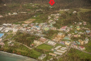
- Initial damage assessment from flyover images
|
- By Gert van Dijken <gert at vandijken.com>
- Date: Thu, 21 Sep 2017 07:01:36 -0700
|
|
|
|
- Fwd: Hurricane Maria / Videos of Dominica
|
- By Gert van Dijken <gert at vandijken.com>
- Date: Thu, 21 Sep 2017 06:18:47 -0700
|
---------- Forwarded message ---------- From: <jpermaljac39>Date: Thu, Sep 21, 2017 at 4:46 AM Subject: Hurricane Maria / Videos of Dominica
Images of Dominica
Radio Caraïbes International (RCI) posted images of devastation of Dominica.
Impressive Videos. All houses and trees have been damaged. Infortunately we can imagine the situation of Dominicans today.
|
|
- Pictures
|
- By Gert van Dijken <gert at vandijken.com>
- Date: Wed, 20 Sep 2017 15:07:54 -0700
|
Received from Dominica, via Antigua, by WhatsApp to New York and finally to me...
Apparently the pictures I posted were NOT from Maria, but from Tropical Storm Erika that caused devastation in Dominica in 2015. There was also a picture from Hurricane David (1979), Dominican Republic.
|
|
- HAM Radio Relays
|
- By Gert van Dijken <gert at vandijken.com>
- Date: Tue, 19 Sep 2017 10:20:14 -0700
|
2017-09-18 22:42:15 J73YH Roseau Dominica: River flooded half village, trees down, houses with roofs blown off, homes destroyed, areas between house and his church is "a scene of total devastation". J73CI Clem-Roseau-Dominica-lost his roof of his home and he is in shelter in a small room of his home. J73MH-Roseau Dominica-Lost roof and hunkered down in safe room. J73WA Wayne-Portsmouth, Dominica-Weather station blown off tower, amateur radio antennas and antenna tower lost.
|
|
- HAM Radio Relay
|
- By Gert van Dijken <gert at vandijken.com>
- Date: Tue, 19 Sep 2017 09:41:18 -0700
|
Received from Stuart:
I am a Ham Radio Operator, K4ECD and I have a confirmed radio relay out of Dominica you can post. Frans van Santbrink, J69DS, on St. Lucia recounted a damage report from Kerry Fevrier, J69YH, in Roseau, Dominica. “Trees down, river has flooded half the village, cars are all over, most houses have lost their roofs or are destroyed, the area between his house and the church is just flattened…in his words, ‘devastation is total,’” van Santbrink told the net.
|
|
- Update
|
- By Gert van Dijken <gert at vandijken.com>
- Date: Tue, 19 Sep 2017 07:35:03 -0700
|
It will take a while I am afraid until I hear from my correspondents on Dominica, because of power/phone/internet problems, and obviously different priorities. Below a statement from the Prime Minister of Dominica, Roosevelt Skerrit:
“Initial reports are of widespread devastation. So far we have lost all what money can buy and replace. My greatest fear for the morning is that we will wake to news of serious physical injury and possible deaths as a result of likely landslides triggered by persistent rains.
“So, far the winds have swept away the roofs of almost every person I have spoken to or otherwise made contact with. The roof to my own official residence was among the first to go and this apparently triggered an avalanche of torn away roofs in the city and the countryside.”
|
|
- 3.35 p.m. Monday
|
- By Lisette Stevens <jaco.lass at gmail.com>
- Date: Mon, 18 Sep 2017 15:39:09 -0400
|
We still have electricity! The rain is getting very heavy and the winds are picking up. The dogs have finally settled at my feet, they feel the tension too. We are praying for everyone in Dominica. We have been told that the worst will hit at 10.0 p.m. tonight. We thank Domlec our electricity company for keeping the electricity on for this long!
We so hope our sister islands are going to come through Maria fine! |
|
- Thank you
|
- By Lisette Stevens <jaco.lass at gmail.com>
- Date: Mon, 18 Sep 2017 12:37:52 -0400
|
Thanks to everyone sending us there positive thoughts and thinking about us here in Dominica. We still have power and are OK so far. We will keep in touch as long as possible.
It really makes a difference to u all in Dominica that the outside world is watching us now.
|
|
- 'Chebe' Fort'... We are bracing
|
- By Micheal Colaire <nichs2002 at yahoo.com>
- Date: Mon, 18 Sep 2017 15:56:47 +0000 (UTC)
|
|
Thanks for the heads up from our Martinique correspondent & for the use of the creole vernacular... In Dominica we are sure to brace ourselves (Chebe Fort) as usual for what may come, while remaining hopeful & prayerfully optimistic about the best possible outcome.
I pray & trust that by now everyone is safe & well indoors as the rains become more heavy.Given the likely impacts we hope that none of the eastern villages get too badly affected etc.
Unfortunately, Hurricane Maria is now a category three -well ahead of the original forecast SMH- & is still to our south east... Again weather & hurricane forecasting on a whole is not an exact science, & regrettably once again the 'Lesser antilles rule' zone has led to rapid & explosive intensification of yet another major atlantic hurricane.
Whatever comes folks please do remain safe in the Lord at your respective locations, and I know He will shelter us under his wings, & keep us safe if we too are likewise well prepared, & Smart in all our safety decisions.
Everyone, please Keep safe and out of danger. This is a very powerful major hurricane already. Keep vigilant, but stay Calm. & All of God's speed to the islands north of us. God Bless! |
|
- You bitch Maria go away
|
- By Lisette Stevens <jaco.lass at gmail.com>
- Date: Mon, 18 Sep 2017 11:05:15 -0400
|
We decided to stay in our home in the valley and take our chances with hurricane Maria. It looks like we are going to have a direct hit. We are pretty sure that we will be cut off by landslides and not at all sure that the new bridge that was finished never used will stand after this!! We certainly hope so!
What a total disaster for Dominica! Also the other islands in Maria's path.
|
|
- Maria in Dominica
|
- By Peter Dick <peter at balvine.com>
- Date: Mon, 18 Sep 2017 15:42:47 +0100
|
I spoke to our man Julian this morning and can
report as at 10:30am (local time) today, Monday 18th September:
a) The Prime Minister has decreed all Government buildings,
including schools, are closed for today.
b) During the 24 hour period ending 7am (local time) today, 53.3
mm (aka 2.1 inches) of rain fell at Balvine, Picard in the North
West of Dominica.
c) As at 10:30am all electricity systems and the internet are
still working fine.
Bye/P
|
|
|
- 'A grace-period...'
|
- By Micheal Colaire <nichs2002 at yahoo.com>
- Date: Mon, 18 Sep 2017 11:22:29 +0000 (UTC)
|
|
In the interim before what is likely to be some stronger bands from hurricane Maria later on- some stores and grocery/ hardware outlets will open for limited hours (3hrs) with the consent of their employees of course in order to facilitate anyone needing to make literally last minute preparations and the like.
I suspect that the light rainfall falling at present is quite deceiving... well as always- time will tell. History does seem to be repeating itself in some ways. Memories of the epic 1995 season are still vivid for most in Dominica. First came Iris, then major hurricanes Luis & Marilyn. Here again ironically is not only another M -named storm, but an identical feminine named system at that...
Indeed, the best historical analogue for a hurricane that follows the current NHC forecast for Maria may very well be Hurricane Marilyn of 1995. For Hurricane Irma given its Caribbean track- Hurricane Donna of *1960 (a near Category 5) was the most likely the best historical analogue.
Keep safe folks! God Bless!
|
|
- 'Eye' on Maria...
|
- By Micheal Colaire <nichs2002 at yahoo.com>
- Date: Mon, 18 Sep 2017 10:27:22 +0000 (UTC)
|
|
So far there have been mostly moderate showers, and I would think the same is true island-wide. Thankfully, conditions are not too bad with pretty light squalls on a whole.
Of course, the centre of Hurricane Maria remains to our south at this point - so the next few hours will be a real sort of litmus test as to what is still to come... Hopefully, the impacts will not be too bad in the end.
Keep safe everybody!
|
|
- Maria in Dominica
|
- By Peter <silverware_uk at hotmail.com>
- Date: Mon, 18 Sep 2017 07:09:47 +0000
|
I am not on the island. I will get you a report from our one and only employee
as soon as I can.
Sent from my expensive iPhone
|
|
- Witnessing- the Dangerous 'Lesser Antilles Rule' Zone
|
- By Micheal Colaire <nichs2002 at yahoo.com>
- Date: Mon, 18 Sep 2017 02:32:02 +0000 (UTC)
|
Copied just Below is the almost directly prophetic Quote from Dr. Jeff Masters' Wunderground blog site (caption-Dangerous TD 15 headed for Eastern Caribbean...) - early on Saturday morning (16/09/2017).
"...But I would not be surprised to see (Now Hurricane Maria) -then as- TD 15 become a major hurricane by Wednesday, given how Hurricane Irma exploded into a major hurricane under similar conditions and in a similar location..."
And that location as cited by Dr. Jeff Masters is the exact area that I have dubbed as the zone of the 'Lesser Antilles rule.'
Essentially, this highly & distinctly favourable zone for even most struggling tropical systems spans westward from about 55W longitude towards the immediate vicinity of the Lesser Antilles islands.
Unfortunately, every tropical atlantic system so far this year has taken advantage of this zone where its pretty much a given that added intensification will occur. In fact, explosive intensification occured with both Catastrophic Hurricane Irma, & major hurricane Jose...
Sadly Hurricane Maria is now definitely not an exception. Hopefully impacts island wide will be no worse than during Hurricane Dean (2007).
We are watching & praying... So far a couple of moderate bands seem to have affected most parts of the island with some showers. It will likely be a long night into the morning apparently.
Indeed, this period is quite reminiscent of the 1995 season (Re: hurricanes Iris, Luis & Marilyn) except that this is a far more deadly season already than 1995 ever was. Thanks for a great post by our Bonaire Sister- Ann P. among the countless others on this site by some correspondents... Indeed, in the very midst of adversity for those of us with faith there is Much Hope; in the face of darkness- light, & in the face of death- abundant life in Jesus' Name! (John 10:10)
As we strive to overcome these adversities may we as one region Always Remember that God Works All things (All) for good (Rom 8:28)... bringing good even out of the worst situations. Though at the moment we may really fail to understand it all. But, there is assurance in trusting that God Be for us... & No matter what comes We are More than Conquerors in Christ Jesus the Lord!
Fellow islanders let us keep strong & Keep the faith...
God has certainly seen us through Countless disasters before, even those we may not readily recall... He has done it in the past, & He will see us through again. He is With us Always! (Matt 28:19)
& we can do All things through Christ Jesus who strengthens us ! (Phil 4:13)
The past is a testament that This region and its people are hurricane strong, & we will Overcome!
Keep safe Eastern Caribbean, & Blessings to All! |
|
- *Good News...?
|
- By Micheal Colaire <nichs2002 at yahoo.com>
- Date: Sun, 17 Sep 2017 18:03:30 +0000 (UTC)
|
Happy Sunday/ Day of the Lord everyone! (Rev 1:10) Hoping we are all having a Grace-filled day inspite of the looming stormy weather impacts...
Well, what a season this has been... God forbid if this is any hint as to what may become normative due to Climate change in a warming global environment.
Thus, far there appears to be a silver lining for the Nature Island Dominica & the other sister isles- as T.S. Maria thankfully does not seems to be in a hurry to organise or strengthen for now.
Of course, tropical systems have been know to rapidly strengthen as was the case with Catastrophic Hurricane Irma, & a lot can happen intensity-wise in a matter of 12hrs.
Nonetheless, thank God the current situation seems to bode well, or at least better for the Eastern Caribbean for the time being...
Those outermost bands which affected Barbados should be heading Dominica's way by later this evening or so.
Its been a while since the island has been under a Hurricane warning, probably since hurricane Dean, 2007.
However, most persons seem to have prepared as best as they could, including Spiritually...
No doubt those fervent Sunday Holy Mass & worship prayers must have had some positive impact.
Come what may -let's All keep safe & Vigilant!
God Bless!
|
|
- Maria
|
- By Lisette Stevens <jaco.lass at gmail.com>
- Date: Sun, 17 Sep 2017 07:45:43 -0400
|
|
We are all praying here in Dominica that we Maria is not Erika the second, it could be a catastrophe for Dominica. We will just have to wait and see and hopefully live for another day!! What a season so far. I really like Stormcarib and Gert a lot. We think there is a lot of false reporting on the weather by other websites. Here we all have a say and report on our islands it is excellent. We wish all the islands to be affected by Maria a lot of good luck. Let us hope we do not have too much rain and wind!!!
|
|
- The Aftermath
|
- By Lisette Stevens <jaco.lass at gmail.com>
- Date: Tue, 12 Sep 2017 08:53:25 -0400
|
Dominica can breath a huge sigh of relief! We have been incredibly lucky! We had no damage from Irma or Jose, in fact both hurricanes decided to skirt around us!! We had a couple of heavy showers with thunder and lightning. We made the decision to leave our valley as with trees around us and a landslide that has not been addressed above us and having one way out of the valley we decided it was safer to move close to Roseau!! The sheer stress of moving with our two dogs, bringing necessities with us was nerve wracking without thinking of bracing ourselves for Irma! We had been through Luis in 1995 22 years to the day of Irma, it was only too fresh in our minds! We cannot believe how very lucky we are here in Dominica. We were so pleased that our friends in Antigua were spared too but poor Barbuda. What absolute heartbreak for everyone living there, their homes destroyed. St. Martin, Tortola, Virgin Gorda and so many more island devastated by hurricane Irma. Our heart goes out to every person affected in every island and Florida as well. These hurricanes are unbelievable, it is really getting very scary each year to see these hurricanes getting stronger, global warming has to be a reality! Plastic debris and waste in our oceans! What a very sad world we live in today.
|
|
- Potential Double Whammy?...
|
- By Micheal Colaire <nichs2002 at yahoo.com>
- Date: Sat, 9 Sep 2017 06:03:03 +0000 (UTC)
|
As more and more videos, stories & horrific footage emerge from the hardest hit islands -it becomes increasingly heart-breaking to watch, & devastating to take it in as the latest version of reality for our Northern-most Sister Isles.
More significantly, its gut-wrenching & quite distressing to know of the unknown numbers of islanders who may have to bear yet another night without basic or ample human necessities especially the very young. These concerns are the essence of what constitutes a true heart -ache for one's fellow human being... Though Strides are being made, however, the slowness with which aid & medical care may end up being made fully available could be detrimental to those who are critically needing attention. Again the Young & the elderly are Most vulnerable. Let us Pray & Hope that All those co-ordinating these respective recovery efforts will be able to do so in the most efficient, humane & comprehensive way possible!
Unfortunately, the fact that Major Category four, Hurricane Jose is threatening to make an unwelcomed brush with the Leewards mere days after hurricane Irma- signifies that an Unprecedented & catastrophic demonstration of the 'Lesser Antilles rule' was being witnessed. It has been glaringly, & undeniably on shocking display with the near record intensifications of Catastrophic Category Five Hurricane Irma, & Now Major Hurricane Jose just east of the Lesser Antilles Islands. Jose is now the latest such suprisingly- intensified system in that favourable region (box), which despite originally not being forecast to achieve a high-end category 3 status has remarkably strengthened to a high end dangerous category 4 storm/ borderline category Five hurricane within a 24hr period. Justifiably, the 'Lesser Antilles box' which covers the area just to the east of the islands from about 55W - 62W Longitude has certainly been an incredible fuelling hot spot for most of the systems in that area so far irrespective of shear, & related moisture values. Given ongoing global Climatological changes these latest intense storms may infact be very sad harbingers that we're not only in a more active period of tropical activity, but one that seems determined on being dangerously destructive as well.
Keep safe Everyone, & for the remainder of this season, & May God Richly Bless us All!
Also, Wishing very Special Blessings to Dave & Gert & those behind the scenes for the Blessing of this great Blog-site! |
|
- IRMA
|
- By Lisette Stevens <jaco.lass at gmail.com>
- Date: Thu, 7 Sep 2017 14:23:48 -0400
|
We have not been online! Why? Irma, so scary! What a monster! We were just rooted to the spot! We had been through LUIS in 1995 22 years to the day of Irma! To be honest we have never ever got over the trauma of LUIS.
We seriously hope that this weather is not man made!!! This would be the work of the devil worse than any horror movies. HAARP the history channel on you tube has some interesting thoughts.
|
|
- BREATHING A SIGH OF RELIEF? -POST ALL CLEAR PERIOD...
|
- By Micheal Colaire <nichs2002 at yahoo.com>
- Date: Wed, 6 Sep 2017 19:34:55 +0000 (UTC)
|
|
Firstly, my Sincere thoughts & Prayers for All those so severely affected in the Northern Leeward islands... Indeed, We shall overcome this disaster as One Caribbean region!
Currently, athough scattered downpours continue, no doubt Most Dominicans are breathing a sigh of relief today following the passage of Extremely dangerous Hurricane Irma to the north of our Lovely Nature Island of the Caribbean, Dominica.
Indeed, we are TRULY Fortunate & blessed in Dominica *(this time around though), thank God. However, we MUST Become better Prepared & Resilient in the future! Honestly, I cannot begin to imagine (God forbid) if the eye of Hurricane Irma had struck Dca or even another Windward island...
We have been spared; Praise God, but given Climatological history- its inevitable that Our turn Will come. Again this is not an attempt to be pessimistic, but Realistic- (There is a rough cycle for each island's worst storm impact to re-occur, & our Next David/Erika -potential nightmare looms large).
May we very humbly Learn MUCH from the damaging Lessons of our dear Brothers & sisters further north!
Love, Prayers & Solidarity to those worst affected...
Keep safe Everyone!
& God's Precious Speed to All of the islands! |
|
- Potentially Massive Catastrophic impacts...Leewards/ St. Martin etc.
|
- By Micheal Colaire <nichs2002 at yahoo.com>
- Date: Wed, 6 Sep 2017 13:17:38 +0000 (UTC)
|
As day break unfolds- Irma's potentially massive catastrophic impact is likely to become clearer in the Northern Leewards- especially in those areas worst hit by the eye; St. Martin/ Maarten, St. Bathelemy, & Barbuda.
In French side (St. Martin) The devastation appears to be horrific, & french reports from there have described a very grim reality so far.
The storm's huge breadth & scale is apparently being felt All the way to Trinidad where southern-most extremity bands and moist inflow/ convergence has generated a train like effect of thunderstorms/ thundershowers in the Trinidad region. I hope the necessary measures will be put in place there should it worsen... (Lessons learnt from Houston- Re:- hurricane Harvey?)
Oddly the ongoing occasional meteorological denial of feeder band effects from Tropical systems continues in TnT for some reason- (as way the case with T.S. Don etc.) Although they are clearly now being affected by the moisture flow feeding into extremely dangerous & Potentially Catastrophic Category 5 Hurricane Irma. The outflow from Extremely dangerous Hurricane Irma will likely continue to negatively affect this area & the rest Eastern Caribbean.
A massive recovery operation will likely be underway no doubt in the days following as tragically -as it seems that more related footage & reports emerging now, and from just before the failure of communications across the Northern-most Leewards, sadly does Not paint a pretty picture at all. Let's pray for the soonest efforts of Aid, emergency disaster response & assessments, and recovery & re-building efforts effecting a stronger and more resilient tomorrow in all the worst affected areas!
Be strong One and All -Fellow Islanders!
God Bless! |
|
- Prayer & Praise - Never Panic...
|
- By Micheal Colaire <nichs2002 at yahoo.com>
- Date: Wed, 6 Sep 2017 05:15:21 +0000 (UTC)
|
As the spiral bands from Potentially Catastrophic hurricane Irma return to continue to criss- cross the northern-most windward & the Leeward islands let us still remember to lift up Prayer & Praise in ALL things!
THIS TOO SHALL PASS! In the Nature Isle thankfully We have had a bit of a lull in shower and squall activity, however, persons should not let their guard down as tropical storm conditions are likely to return & pick-up by early morning hours across the island... Several videos have been making their rounds on the net- And one of the most striking appears to be some sort of vortex, or tornardic impact apparently on the island of Barbuda earlier today... Let's truly hope that everyone comes through okay and alive in the Northern Leewards.
Here's some rather note-worthy & interesting facts about this monster storm as also noted on the weather underground site:- Only three hurricanes in the satellite era (since *1966) have hit the Leeward Islands with winds of 150 mph or greater: David (1979), Hugo (1989), & Lenny (1999). All three hurricanes caused major damage on the islands they hit, and we can expect Irma to cause extreme damage to any island it makes a direct hit on.
According to Dr. Phil Klotzbach, Irma was tied with Rita (2005) and Mitch (1998) as the fifth strongest hurricane in Atlantic, records going back to 1851, based on maximum wind speed- earlier on Tuesday. (180mph) The minimum pressure measured by a dropsonde in the eye was 926 mb *earlier on Tuesday afternoon. Then, Irma became only the fifth Atlantic basin hurricane with a peak wind speed of 160 kt (185mph) or higher. The others are Allen (1980), the Labor Day Hurricane of 1935, Gilbert (1988), & Wilma (2005). Nonetheless, eyewall replacement cycles can lead to fluctuations in intensity... These changes in inner-core structure will likely result in some fluctuations in intensity during the next couple of days. (Although Potentiall Catastrophic Hurricane Irma's intensity has been remarkably consistent.) Otherwise, increasing upper-ocean heat content & a very favorable upper-level pattern are expected to allow Irma to remain a category 4 or 5 hurricane over the next several days.
Irma is also the first Atlantic hurricane *outside of the Caribbean & Gulf of Mexico known to attain 185-mph sustained surface winds. The lowest central pressure measured *Outside the Caribbean & Gulf was 919 mb in Hurricane Gloria (1985), but Irma did end up breaking this record as well- by 8p.m.- Tue, Sept 5th -when Extremely dangerous & potentially Catastrophic Hurricane Irma became even more powerful & intense as its latest minimum central pressure dropped to 916mb. This is the absolute lowest minimum pressure for a hurricane ever recorded at *THIS Location -East of the Lesser Antilles! Truly jaw-dropping stuff!
Of course, the Highest winds of any Atlantic hurricane are 190 mph, set by Hurricane Allen (1980) while in the Gulf of Mexico, and Irma may approach that record also. According to several weather experts (Weather-underground) -the best historical analogue for a hurricane that follows the current NHC forecast for Irma may be Hurricane Donna of *1960 (Category 5)... Which many older persons in the Leewards may very well remember!
Through this All let us not forget to keep our focus on the maker of All things. Come what may -truly Blessed be the name of the Lord!
All possessions can be replaced but our lives & Souls are Most precious. As Jesus Rightly said- What does it profit a man to gain the whole world yet... (Matt 16:26/ Mark 8:36).
The Lord God has been so gracious & intervening in so many different ways in the past, and yet we do sometimes forget to be grateful... Cases in point include even Hurricanes Luis, Bertha, Erika (1997), Georges, Lenny & Omar to a lesser extent just to name a few- which could have indeed been far worse given their intensities etc.
Let us pray that a miraculous intervention may occur sparing the islands from the very worst, or at the very least from any direct loss of life inspite of the damages.
Keep Safe Everyone, & Let's Keep our brothers & sisters in the Northern Islands in constant Prayer!
God Bless!
|
|
- Irma's Effects...
|
- By Micheal Colaire <nichs2002 at yahoo.com>
- Date: Tue, 5 Sep 2017 17:59:00 +0000 (UTC)
|
|
Hi Everyone,
Winds & seas along with moderate to heavy showers from the successive bands of extremely dangerous hurricane Irma are definitely picking up as is being reported island wide. Most persons seem to be in by now... There has also been some thunder, & everyone is praying for the best outcome given the circumstances of a Category 5 hurricane especially for the islands further north.
Keep Very safe Everyone!
|
|
- OMG!...CATEGORY 5 HURRICANE IRMA!
|
- By Micheal Colaire <nichs2002 at yahoo.com>
- Date: Tue, 5 Sep 2017 13:05:18 +0000 (UTC)
|
OMG -Hurricane Irma is now a category 5 hurricane- bearing down on the islands- This is truly an Extremely dangerous & potentially truly unprecedented deadly hurricane making landfall in the Eastern Caribbean... Let's All be extremely aware, vigilant & prudent in All our actions & measures over the next several hours of impact to do ALL that is humanly possible to protect life & property. But more especially LIFE! Our thoughts & prayers are certainly with our fellow Sister islands futher north.
Also, we ought to express some gratitude to the Govt/ Met officials of Barbados who issued a Tropical storm warning for Dominica at 5a.m. Although this warning advisory was really quite overdue... & It seemed issued a bit unduly late in my opinion unfortunately. Again we must continually aim towards greater proactivity, preparedness & higher meteorological sensibilities, acuity & intuition in our unique Caribbean region- especially in the face of such catastrophic threats.
This is certainly historically one of the really most dramatic, & utterly vivid examples of the 'Lesser Antilles rule'- going into effect for a strengthening tropical system approaching the islands in recorded meteorological history... Truly Astounding! This is now a worst case scenario as Hurricane Irma- bears down on the Leeward islands as a now full fledged Category 5! Just unbelievable...SMH.
May God's Abundant graces, preservation & sufficient providence be with Everyone in the islands! God Bless! Keep very safe Everyone! |
|
- Critical Preparation Review...
|
- By Micheal Colaire <nichs2002 at yahoo.com>
- Date: Mon, 4 Sep 2017 17:42:31 +0000 (UTC)
|
|
This is like the proverbial 11th hour...(however better late than never) The following is a helpful checklist albeit at this point sort of 'last minute.'
*GET- your hurricane lamps (glass jar candles) and flashlights. Cut branches close to your house, stock drinking water, and convenience non perishable foods.
Also, disconnect your propane gas tanks especially in areas likely to be flooded, or very exposed to likely severe wind damage etc., turn off the gas, and put them flat on the ground & preferrably sandwich it between blocks or sizeable objects... Unplug all appliances from wall outlets prior to hurricane impacts. If you have rugs on your floor, take them off for good measure.
Do not park your vehicles on flood prone- low lying public roads, or on very steep slopes especially in very vegetated or bushy overgrown areas... Keep your vehicle tank filled with petrol.
Put your important books and documents in two layers of plastic bags just in case your roof is damaged etc. Stock up on medications.
Accordingly, raise your living room furniture on blocks as well, to protect them from possible water damage if prone to floods.
If desirable- start making ice now and bag them in coolers/ freezers etc. -making sure they are on their coldest setting especially if they must be turned off at some point.
Additionally, If large mayonnaise and large dairy products are on your current check list change to the smallest items for ease of preservation.
Iron a few more pieces of clothes this weekend than you would normally do as you may not have power for quite some time after the hurricane... Check on neighbours & the elderly. Make arrangements for care of pets/ outdoor animals especially if near streams/ rivers.
Those with marine interests/ Fishermen etc., plans should be completed to take your boats out of the water- or into safe harbour by today.
(Some of the following was also well highlighted on the weathercarib site)...
N.B. Irma is a dangerous major hurricane; When making decisions regarding preparation, please remember that your target time to be ready is NOT when the eye arrives, and half of the storm has already passed. Please listen to & Read local advisories for the extent of tropical-storm force winds, which may extend at least 100nm or more out from center of storm, and plan to have preparations completed before they arrive... (Conditions should begin to further deteriorate by Tuesday morning). The cone of likely impact is based upon ACTUAL HISTORY of hurricane deviation from forecast tracks, so don't be naive and think anyone can tell you exactly where/ when a storm like this will hit -as growing, powerful storms like this do wobble near landfall.
-All should already have advanced storm preparations (supplies, water, food, medications, records, etc.) Secured & completed, as we enter the peak of this active hurricane season.
Let's Pray that the Lord Jesus will protect us from the worst ravages of this hurricane, which, at this moment, and based on the forecasted track, looks like it will be an almost direct hit on the northerly Leeward Islands by Tuesday/ Wednesday.
Keep alert & prepared, but remain calm... All You Holy Angels & Saints of God, please Pray for Us! & May God Bless Us All!
|
|
- Eerie similarities...
|
- By Micheal Colaire <nichs2002 at yahoo.com>
- Date: Mon, 4 Sep 2017 12:22:17 +0000 (UTC)
|
Indeed, Hurricane Irma seems increasingly very similar to Major Hurricane Luis of 1995- hopefully there isn't a similar Marilyn (1995) like system following on the heels of hurricane Irma (like Jose?)Luis was the most devastating major hurricane to strike the *northern Leeward Islands in the 20th century, and one of the strongest storms to hit the Leeward Islands after Hurricane David *(central Lesser antilles/central leewards/northern windwards) in 1979, and Hurricane Hugo in 1989 (leewards) .
The track of Hurricane Irma could even eventually be like that of Hurricane Debby in 2000 or Bertha (1996), but certainly less like Hurricane Erika of 1997. Again Time will tell.
It appears that surf & wave activity from the hurricane should begin affecting the island chain by later today though.
I trust that everyone has begun to take this hurricane seriously & are earnestly preparing...
Godspeed to All our beautiful islands!
|
|
- Regional readiness...
|
- By Micheal Colaire <nichs2002 at yahoo.com>
- Date: Mon, 4 Sep 2017 03:49:44 +0000 (UTC)
|
|
Now that hurricane watches have already been issued for most of the Leeward islands since Hurricane conditions are likely there by at least as early as Tuesday- Let's all continue to keep these islands in Prayer especially for those most vulnerable. Unfortunately, Hurricane Irma seems to be Intensifying & expanding at the moment...
Its also worth noting that there is a growing POSSIBILITY that the Southern Lesser Antilles May be affected by some of Irma's feeder band activity as the hurricane continues to move slightly South of due west as it approaches the islands- which is expected according to some model projections somewhat into Monday.
If after turning to the West south west or slightly south of due west a more distinct west north westerly track does not materialise soon with Irma then that could mean the difference between bad weather -to very hazardous conditions affecting especially the northern Leeward islands & areas beyond.
Let's hope & pray that All the respective island Governments take this hurricane very seriously. It remains to be seen whether a watch will be issued for the Nature Island of the Caribbean, Dominica by some time tomorrow. Of course, its better to be safe & prepared than sorry (even though some may want to remain in denial as a coping strategy- we must All be proactive in disaster mitigation in the region as we bite 'the readiness bullet') Let us remember to Not let our guard down...& Always be Prepared!
God Bless our Islands Always! |
|
- IRMA
|
- By Lisette Stevens <jaco.lass at gmail.com>
- Date: Sun, 3 Sep 2017 14:35:30 -0400
|
Oh Irma you are a very troublesome woman! You are wheeling towards the Leewards and outer bands to us in Dominica! What makes you so very mean?
We are feeling deeply sorry for everyone going to be affected in Irma's path including us. Irma you look very threatening and angry. What a world we live in and so many believers that global warming does not exist. To all of you wake up and smell the coffee.
|
|
- Glorious sunny day!
|
- By Lisette Stevens <jaco.lass at gmail.com>
- Date: Sat, 2 Sep 2017 11:51:50 -0400
|
We are all watching IRMA with the closest eye. Hopefully she will stay high and not veer towards us and the Leawards! Only time will tell and we are all praying big time. We here in Dominica are watching IRMA closely. We went shopping yesterday and many Dominicans were doing a really good shop and talking about the coming of IRMA or should I say, the not coming of IRMA as some fervently believed that the hurricane can come if it wishes, they were not going to make any arrangements at all and take what Irma would give them if she arrives! Having been through LUIS I tried to enlighten them only to be laughed at!! I found this very sad indeed. What do they say you can take a horse to water but you can't make it drink.
The way the weather is today you could not imagine a storm is out there hammering down on any of us. We just need a bit of magic to steer IRMA away from us all.
|
|
- IRMA
|
- By Lisette Stevens <jaco.lass at gmail.com>
- Date: Thu, 31 Aug 2017 10:51:01 -0400
|
The weather today is beautiful. We are so saddened by Harvey's destruction in the last few days. We had a touch of Harvey as he was gathering strength. We feel very sad for the people affected by Harvey and then there are the floods in the Asia and the loss of life and homes, what sad times we are going through. Our thoughts go out to everyone around the world affected by all this weather situation! If people do not believe in global warming after all of this, I feel sorry for them indeed!
Dominica is breathing a sigh of relief that we have got through August unscathed! We now have a watchful eye on Irma, Irma looks like she could be a mega hurricane and the Caribbean Islands do not need her at all. It is possible that Irma could hit us in Dominica and this would surely be tragic. Irma looks on a path towards the Leeward islands and this has to be causing a lot of distress as hurricane LUIS hit the Leeward islands in 1995, causing terrible devastation on all the affected islands. All we can do is watch, wait and pray for the best. We are halfway through the hurricane season. This has just come by us http://thedominican.net/2017/08/hurricane-irma-threatens-caribbean-islands.html |
|
- Thoughts & Prayers... Anniversary
|
- By Micheal Colaire <nichs2002 at yahoo.com>
- Date: Thu, 31 Aug 2017 05:32:00 +0000 (UTC)
|
|
Hi Everyone!
While we continue to enjoy beautiful weather here in the Nature Island of the Caribbean, Dominica, there is much time for necessary reflection, & preparation for the 'heart' of the Atlantic Hurricane season which is pretty much upon us. Unfortunately, T.S. Irma, which appears to be almost near hurricane strength seems to already be eyeing at least the Leewards of the Lesser Antilles islands, & possibly areas beyond. As always -time will tell...
On that note thankfully Dominica's 38th anniversary of the notorious Hurricane David (dubbed- David- the Goliath) on Tuesday 29th August (1979)- passed uneventfully. As this year's Hurricane season progresses -Let us All continue to remember in our thoughts & prayers those who are suffering the misery of hurricanes & storms globally, and especially for those who have been hard hit in Texas. And as we enjoy our current lull in Caribbean storm impacts may we All remember to count our Blessings here in the islands- not neglecting to Prepare as best as we can ahead of any possible hurricane landfall!
God Bless! |
|
- Heads-up- Hurricane Harvey...
|
- By Micheal Colaire <nichs2002 at yahoo.com>
- Date: Fri, 25 Aug 2017 14:28:18 +0000 (UTC)
|
|
Hurricane Harvey is putting on quite a burst of intensification indeed- with a current minimum central pressure of 950mb, (110mph) its certainly just on threshold of Major hurricane status- if not already there at this point... The hurricane hunters will certainly be kept busy.
I pray & trust that those in its path especially along the Texas & Louisiana coasts etc. are as well prepared as they can be. Let's also hope that we don't ever have to face such a powerful storm in the remainder of the hurricane season!
Keep safe & prepared everyone as we go into the peak of this year's season!
|
|
- Gorgeous Weather & Partial eclipse Treat...
|
- By Micheal Colaire <nichs2002 at yahoo.com>
- Date: Tue, 22 Aug 2017 04:46:22 +0000 (UTC)
|
|
There's been absolutely Gorgeous weather in Stunningly beautiful Dominica, the Nature Island of the Caribbean. Regular Blue skies were only occasionally interrrupted by some brief scattered showers, which really help to keep the island cool & comfy... One truly could not ask for more in this part of the World! Also, afternoon cloud cover parted sufficiently in time for the peak viewing period of the awesome Partial Solar eclipse which climaxed at around 3:50p.m our time. (AST) It was quite a celestial treat whilst being totally immersed in ecological paradise!
Around this time of Year the Nature Isle has a truly special & extremely amazing lush green appearance that is unbeatable! Thankfully, t.s. Harvey did nothing to spoil any of that... & Of course, we are very grateful that apart from a few moderate to heavy showers, and the occasional squall?, there- was nothing to be alarmed about.
My thoughts & Prayers continue to go out to all those in the Sister islands who were adversely affected by Tropical Storm Harvey in Barbados, St. Vincent & in S Lucia.
Let's All stay Prepared & Vigilant!
God Bless!
|
|
- Still raining
|
- By Lisette Stevens <jaco.lass at gmail.com>
- Date: Fri, 18 Aug 2017 15:30:04 -0400
|
It is 3.20 pm. We have had heavy rain on and off all day we are still experiencing heavy rain. We are so sad for our sister islands. We do not know of any damage here! We hope not too much and we have just had a lick compared to our sister islands! Our main newspaper online has reported that since 2.0 p.m. we have no more weather:- http://dominicanewsonline.com/news/homepage/news/weather/tropical-storm-watch-discontinued-for-dominica-2/ However here in the valley we are experiencing heavy rain! We wish everyone well! We will keep posting. One Love to everyone. |
|
- Easy night
|
- By Lisette Stevens <jaco.lass at gmail.com>
- Date: Fri, 18 Aug 2017 07:56:18 -0400
|
|
we are very thankful. We have had some rain in the night quite heavy but not too bad. Reading reports from St Lucia they seem to be getting heavy rain and little let up. It is raining here heavily as I write this. Looking at the weather it looks like we are half way through tropical storm Harvey. We will keep in touch through the day. We are thinking of everyone. We hope we all stay safe.
|
|
- Leading bands/ mid-level edge system...
|
- By Micheal Colaire <nichs2002 at yahoo.com>
- Date: Fri, 18 Aug 2017 01:08:28 +0000 (UTC)
|
|
Current infra-red satellite imagery seems to suggest that there is a mesoscale type mid- level low pressure system along with the leading outer bands of tropical storm Harvey that is already affecting Barbados. Some of these features can be typical with developing tropical systems like Harvey.
Hopefully we are all prepared as best as can be- its always better to be safe than sorry, & never under-estimate any developing tropical system as every storm is different... Let's pray that there are no severe impacts in any of the islands.
Stay safe Everyone! God Bless!
|
|
- *Pro-active Meteorology...
|
- By Micheal Colaire <nichs2002 at yahoo.com>
- Date: Thu, 17 Aug 2017 18:29:13 +0000 (UTC)
|
|
The decision of the Commonwealth of Dominica/ Antigua Meteorological services to effect a Tropical storm Watch for the Nature Isle; Dominica is indeed commendable. Given previous precedents (notably -case in Point being T.S. Erika) where this wasn't done -today's national advisory initiative is indeed a welcome change. Of course, much advocacy and appropriate inquiry & blaming followed the Erika tragedy, which hopefully has led to a sustained, & logical sensibility to always err on the side of precaution. In addition to being less reluctant to readily utilise advanced use of all warning & watch advisories available to fully sensitize the general populace threatened by any named or Potential tropical cyclones.
:-(Potential tropical storm 9) (Pre -T.S. Harvey) poses a real threat for the Central & Southern Windwards...
This is a Necessary proactive measure & something that has been requested by the wider meteorological community for a long time in the interest of safeguarding life & property in the most time-efficient & effective manner possible.
Under the adopted precautionary warnings -the tropical weather disturbance -formerly known as 91L is now titled as potential Tropical storm 9 -for which advisories are being issued.
Its a bit of technical weather jargon, but a potential tropical cyclone is essentially defined as a disturbance which has not yet become a tropical cyclone, but which poses the threat of bringing tropical storm or hurricane conditions to land areas within 48hrs or less & is generally already at tropical Depression status.
Keep safe Everyone! & God Bless!
|
|
- Weather alert!
|
- By Lisette Stevens <jaco.lass at gmail.com>
- Date: Thu, 17 Aug 2017 13:37:18 -0400
|
Well 91 L! It is the most amazing beautiful day in the valley! The sun is shinning and I am cooking up a storm!! My hobby baking! Very relaxing and extremely tasty!
So it looks like Dominica could be swiped. It is two years today that Erika presented herself. It seems only in August, that Dominica gets dumped on. The famous Hurricane David in 1979, not to mention the others leading up to Erika.
We have not got over Erika there are many damaged roads still the same as the day Erika came. Our road from the Hillsborough Bridge to Ponte Casse was the best road in the island! It is now probably the worst, not really passable.
We have a landslide that has not been addressed or fortified it is not if it will fall it is when it will fall. If this happens then a lot of us will be cut off including the really good functioning abattoir!!
I have to say I wonder at some people who post on stormcarib! It is as if they are really excited about getting hit by a big storm! God forbid! Laurie and I went through LUIS in Antigua in 1995. I can assure all of you it is not fun and it is not exciting it is terrifying and destructive and peoples lives can be lost!
I pray for the safety of everyone and that 91L does not hit us!
|
|
- Intensification...PTC 9
|
- By Micheal Colaire <nichs2002 at yahoo.com>
- Date: Thu, 17 Aug 2017 15:11:25 +0000 (UTC)
|
|
As was feared, yet Anticipated 91L has officially been designated as Potential Tropical Cyclone 9 (PTC # 9). (Pre Harvey) Let's hope & pray that the Lesser Antilles rule which appears to very much favour & enhance intensification of tropical systems does not lead to any rapid strengthening of PTC 9 as it crosses the islands...
Of course, given the current radius of the storm's convective coverage its unlikely that Dominica will be placed under any watch/ warning. However, given that we are likely to be on the side of the storm's northern quadrant- some squally weather and stormy conditions certainly can't be ruled out into tomorrow. Time will tell... All the best to the sister islands further south as the Storm's moisture field may expand further.
Let's All remain Prepared & Vigilant- come what May.
God Bless!
|
|
- (LAR) -Vigilance zone...
|
- By Micheal Colaire <nichs2002 at yahoo.com>
- Date: Thu, 17 Aug 2017 09:36:23 +0000 (UTC)
|
Hi Everyone!
91L certainly bears watching as it continues to near our Lesser Antilles islands...
Of course, the 'Lesser Antilles Rule' (LAR) will expectedly be coming into effect as 91L may be increasingly continuing to slowly organize & intensify at that point.
(Let's hope Not)
One of those critical meteorological markers for most tropical disturbances nearing the islands including this system will be its potential strength by the 55W longitude line and beyond...Even the most recent weak tropical wave seems to have been amplified and enhanced a bit by the LAR while affecting the islands.
However, I'm hoping that this current tropical wave & TUTT is not affecting the B.V.I. area too badly especially in light of the serious flood event they experienced about a week ago.
Again- time will tell with 91L, but as always we'll do well to continue to monitor its progress rather closely, in addition to the other invests.
Keep safe & prepared everyone!
God Bless! |
|
- Weekend threat looming?
|
- By Micheal Colaire <nichs2002 at yahoo.com>
- Date: Wed, 16 Aug 2017 03:06:44 +0000 (UTC)
|
|
Greetings to one & All,
Wishing our dear Gert, a very happy birthday! & asking that the good Lord Jesus would grant him many more Birthdays & hurricane free days to come...
Of course, I'm Continuing to keep an eye on 91L etc. Although it now seems that the system currently exiting the African coast may be the most intense system yet. Time will surely tell... The 'Lesser Antilles (rule)' & associated storm intensification effect appears to have been a bit delayed with Gert, however, we'll have to see what exactly will transpire with this latest system. Hoping for the best, & a storm free weekend.
Let's All continue to be vigilant & prepared.
|
|
- Monitoring...
|
- By Micheal Colaire <nichs2002 at yahoo.com>
- Date: Tue, 15 Aug 2017 08:59:00 +0000 (UTC)
|
Greetings everyone!
I quite like Gert's remarks on Sunday about the latest formed storm, which is also his name-sake.
Given the storm's current behaviour & projected path its really proving to be a- Gentlemanly, & gentle storm Gert albeit it has now become a hurricane (#2 of the season).
Indeed, storms staying away from land areas is certainly how we like our systems... although Gert is forecast to probably become a bit stronger as a hurricane.
However, that being said- 91L etc. definitely bears watching & seems like a system to keep our eyes on as the weekend approaches.
Wishing everybody the very best in the days ahead.
Let's All keep vigilant & Prepared!
|
|
- 99L -Nearing 'the spot'?...
|
- By Micheal Colaire <nichs2002 at yahoo.com>
- Date: Wed, 9 Aug 2017 07:57:13 +0000 (UTC)
|
99L appears to be trying its best to organize & intensify slightly as it has entered what I've coined as the "Lesser Antilles Box" which roughly encompasses that region between 52W Longitude and about 62W/ & between 10N- 20N.
This zone (box) favours the Lesser Antilles rule- allowing for slow to possible rapid strengthening of even previously diffuse tropical disturbances as they near or directly cross the Lesser Antilles region. (Time will tell).
Let's hope that 99L does not pull any 'fast ones' directly over the islands like Emily (2011) or Helene of 2012...
Let's keep prepared & Vigilant Everyone!
& All the best to Mexico with Stengthening T.S. Franklin.
God Bless!
|
|
- Ghost of 99L?/ 90L-Newest Tropical Storm...
|
- By Micheal Colaire <nichs2002 at yahoo.com>
- Date: Mon, 7 Aug 2017 03:36:02 +0000 (UTC)
|
Although 99L has seemimgly weakened- Lesser Antilles meteorological history & climatology should serve to remind us to Not let our guard down.
& If the 'pre-designation antics' of post 90L/ former Potential Tropical Cyclone 7-as it neared the islands just a few days ago is anything to go by- then there's a high probability that the "Lesser Antilles rule" will feature once again.
In fact, former 'Potential Tropical Cyclone 7' has just recently been officially upgraded to Tropical Storm Franklin.
Indeed, inevitably most tropical disturbances despite their weakened appearance seem to noticably intensify & organize once crossing the 50-55W Longitude region while approaching the islands.
Of course, there are several cases in Point... Notable ones include tropical storms Cindy & Debby of 1993, 94 respectively, Bertha & Gonzalo (of 2014), & Pre Earl & T.S. Matthew (2016) of more recent memory.
The weather models are truly having a hard time at it so far with 99L, but come what may let's All remain as vigilant and Prepared as possible during this current peak of the storm season. Hopefully, no bad surprises will be lurking on the horizon, & I pray that Franklin will not be destructive to the Yucatan region & beyond as feared.
A Happy & safe week ahead to Everyone, & God Bless!
|
|
- Wet weather
|
- By Lisette Stevens <jaco.lass at gmail.com>
- Date: Fri, 4 Aug 2017 08:14:55 -0400
|
|
This latest wave bought three days and nights of damp wet weather, in fact temperatures were pretty chilly especially yesterday! It rained hard all night and the Layou River is loud roaring down below us as I write. In the evening the frogs sing their hearts out! Last night I was on the telephone to a friend and she said that they could hear the frogs singing loudly in the background. We are extremely lucky to live with nature every day here in the valley and never take it for granted! There has been a report of some flooding in certain areas.
|
|
- Well weathered...
|
- By Micheal Colaire <nichs2002 at yahoo.com>
- Date: Fri, 4 Aug 2017 08:54:30 +0000 (UTC)
|
The Nature Island of the Caribbean has come through this latest active tropical wave quite well... This was definitely a wet wave- even by Nature Isle standards with a bit of wind at times, but manageable in my neck of the woods. Of course, Thanking God, & Praising Jesus for small mercies & really hoping that nothing worse may lie ahead for any of the islands as the hurricane season ramps up into its peak months.
Well, true to Climatology the latest wave to come through the islands really seems to have been affected by the "Lesser Antilles rule" as it appeared to definitely strengthen and became much more vigorous while approaching our island chain.Trusting that not too much impact has occured in the other islands...
Keep safe & Vigilant Everyone!
|
|
- 96L -Pre Emily attempts...
|
- By Micheal Colaire <nichs2002 at yahoo.com>
- Date: Thu, 20 Jul 2017 10:27:03 +0000 (UTC)
|
|
Despite the little to no probability of formation given by the NHC for 96L the system has certainly proved its tropical tenacity thus far, & probably should not be written off just yet.
As matter of fact from satellite imagery presentation it definitely seemed to have had its best symmetrical & banding structure during the earlier part of last evening. And it is persisting in struggling to develop even now that it's more east of the islands. Let's see if the "Lesser Antilles rule" may 'kick in' for it as it happened with Bret & Don. It has already had a closed low level center of circulation for quite a while also.
Keep safe & Well Prepared everyone!
|
|
- Mild weather
|
- By Lisette Stevens <jaco.lass at gmail.com>
- Date: Wed, 19 Jul 2017 09:02:42 -0300
|
Luckily, Don disappeareth! Here in Dominica we are enjoying fairly stable good weather. We were keeping a keen eye on the weather system Don and are very glad to see that he is not as bad as he could have been.
August in Dominica tends to be the pivotal month of the H season and is rapidly descending on us. Even though TS Erika didn't attain H status, the damage still remains in some communities and it's wise to treat every system that forms as threatening. We keep fingers and toes crossed that we have a hurricane free August month!!!
|
|
- Ironically 'deceitful Don?'
|
- By Micheal Colaire <nichs2002 at yahoo.com>
- Date: Wed, 19 Jul 2017 05:03:53 +0000 (UTC)
|
Although at this point Don accordingly (11p.m. NHC advisory) has been officially downgraded to an open wave similar to the likes of T.S. Bret after T & T impact -Nevertheless, the post Don system seems to be maintaing its banding structure, and from all accounts Re:- Venezuela's radar it appears to have strengthened its closed low level center of circulation somewhat shortly after passing just south of Grenada. At this point the former tropical storm- a bit ahead of the forecast timing is headed near the 'ABC' Dutch isles as a weakened yet potent tropical disturbance. I hope not too much guard is let down there. Preparation & vigilance are paramount!
This year has already had some surprises... Let's hope Don does not decide to regenerate at some point down the road. & Wishing all the best to the Southern isles in the aftermath -should there be anything of consequence.
Keep safe everyone! God Bless! |
|
- Southern Isle impacts (TnT)...
|
- By Micheal Colaire <nichs2002 at yahoo.com>
- Date: Tue, 18 Jul 2017 23:35:50 +0000 (UTC)
|
|
Unfortunately, reports of ongoing flash flooding continues to emerge at this time out of Trinidad... Hopefully, the 'river limers' which I mentioned in my earlier post -at the Caura river in Trinidad have been rescued by now and are safe.
Links giving reliable updates about Tropical storm Don effects in Trinidad can be followed here: at Trinidad & Tobago weather center- https://m.facebook.com/TTweathercenter/posts/?ref=page_internal&mt_nav=1
Our thoughts & prayers are with Our southern isle brothers & Sisters at this time.
Keep safe everyone! God Bless!
Links in the message
 | Security Check |
|
|
- Indispensable preparation...
|
- By Micheal Colaire <nichs2002 at yahoo.com>
- Date: Tue, 18 Jul 2017 21:38:53 +0000 (UTC)
|
Hoping for the best overnight for our Southern sister isles!...
So far I have noted the seeming disconnect between the Trinidad & Tobago Meteorological services, & the Trinidad & Tobago weather center, which would be quite humourous if it weren't so tragic & potentially deadly to its citizenry.
It is indeed quite troubling - given the obvious impacts of Tropical Don in Trinidad & Tobago that the T & T Met office is still denying the rather crystal clear connection between earlier heavy bouts of precipitation & convection mainly over Trinidad -from any direct connection to Tropical Storm Don which is now Clearly still affecting them.
Instead, amazingly a bulletin issued by the met office at 3:45p.m. today (18th July)- attributed the unusually heavy rainfall so far to exclusively "local dynamics due to intense day time heating & light low level winds" (page 1 of 2)
The met office's explanation that the rounds of heavy rainfall was entirely due to local dynamics really seems quite laughable.
I suppose the Met service may be trying to 'save face' at this point -given that they issued no advisories of course.
Nevertheless, mainly heavy rainfall impacts from Tropical storm Don are continuing at the moment in Trinidad which has been feeling the effects from the outer core/ outer edge & leading bands of the system from earlier today... Unfortunately, Trinidad & Tobago is likely to continue to feel the effects of the feeder bands of Tropical Storm Don into tonight.
For Now Tropical Storm Don given its current position certainly remains a heavy rainfall threat to Trinidad & Tobago & additional heavy tropical showers are at least likely in Trinidad & Tobago as well as some of the adjacent southerly isles.
Keep safe everyone & as advised by the T& T weather service -always do your due diligence with every tropical system threat, which may in fact go quite differently from the 'official forecast' or met office predictions in the end.
(There are reports of some people being rescued at the flooded Caura river site- lets hope that this does not become a 'deadly Don' scenario)
May God Bless us All!
|
|
- Way forward...
|
- By Micheal Colaire <nichs2002 at yahoo.com>
- Date: Tue, 18 Jul 2017 13:45:38 +0000 (UTC)
|
Greetings everyone!
I trust that the preparations are in swing across the southern islands by now.
Remember the adage- always Hope for the best, but be prepared for the worst.
Unfortunately, having delved into some of the discussions hovering around the respective blogs & weather threads it appears like we are at times heading back to 'square one'...
Whilst there are those with almost every threatening tropical system would prefer to be more reactive in terms of a potential island impact; ultimately justifying the reluctance to issue advanced & precautionary advisories like watches & warnings -I do believe the time has arrived for a marked change in regional approach.
It is this precise debate which has been nearly inescapable (over the last two decades to be fair) -that in order for a watch or warning to be issued the respective location should be directly within the windfield of a system i.e. nearly guaranteed to experience storm forced winds, which has proved so controversial over the years.
However, thankfully, a new sensibility which was nobly pioneered by our regional think tank has been successfully adopted by the NHC- in its latest issuance of potential tropical cyclone advisories in which it recognises the critical need to sensitize the public to the dangers of systems; likely bringing tropical storm conditions not only in terms of wind, but also deadly Rainfall capability.
Indeed, water is the main killer with tropical systems- with scores of tropical storms and hurricanes as cases in point.
As the Facebook site of the Trinidad & Tobago weather center critically noted:
...'the key difference between feeder bands and regular moderate to heavy showers associated with a tropical wave is the Intensity of the rainfall as well as gustier winds in feeder bands compared to scattered showers in a tropical wave.'
I hope & trust that we'll all increasingly err
On the side of prudence & caution, & that our regional meteorological services will stand clear of all lack of will power in truly being proactively precautionary & mitigatory in the best interest of All of our citizens.
Stay safe everyone!
God Bless!
|
|
- Deceptive Don?...
|
- By Micheal Colaire <nichs2002 at yahoo.com>
- Date: Tue, 18 Jul 2017 12:00:14 +0000 (UTC)
|
|
As Tropical storm Don continues to near the Islands it's possible that the phenomena which I've coined over the years known as "the Lesser Antilles rule" may go into effect as it usually does when developing tropical system generally strengthen once they are within about 300 miles of the Lesser antilles islands. That being the case -Don has intensified slightly as of the latest NHC 5a.m. update this morning, and may further intensify as it prepares to cross the Southern Windwards- given Dmax etc. at night (favouring strenthening).
Already this is an historic season in -terms of storm origins & timing of impacts so far- with the only other precedents according to the NHC being the notorious years of 1933, & 2005. Additionally, there appears to be a building trajectory trend viz -a vi the models with some future systems down the road...
More the reason for the region as a whole to remain alert & proactive in readiness. Thus, I'm somewhat intrigued by the lack of a storm watch being issued at least for Tobago in the twin island republic up to this point in time. Time will surely tell though...
Lets all keep prepared & vigilant as this maybe a rather bumpy season ahead. All the best to the Southern sister isles, & Let's hope & pray for the Best in Jesus' Name!
May God continue to Bless us All -come what may! |
|
- Cranking up?...
|
- By Micheal Colaire <nichs2002 at yahoo.com>
- Date: Mon, 17 Jul 2017 01:50:29 +0000 (UTC)
|
|
Hi Everyone! I hope that the entire Storm Carib family has had a great weekend & a Glorious Sunday...
However, unfortunately it seems like the lovely island weather conditions may change rather soon given the presence of 95L, and another tropical disturbance just to its east.
After a lull in tropical activity it looks like things may be 'cranking up' once again with possible twin tropical Atlantic systems. Should there be any likely impact- lets hope & pray that these potential systems stay more on the weak side. As Always Pray & hope for the best, But Be sure to make Your best preparation with every tropical system threat.
Top of the week ahead to everyone! & May God Richly Bless us All!
|
|
- Bret is Officially 'Birthed'...
|
- By Micheal Colaire <nichs2002 at yahoo.com>
- Date: Mon, 19 Jun 2017 21:14:37 +0000 (UTC)
|
Potential tropical cyclone 2 (Pre Bret) officially becomes Tropical storm Bret- a historic storm of sorts both in terms of date & latitude. Also, no doubt a sort of deja-vu for Trinidad and Tobago- Re: T.S. Bret back in 1993...
Indeed, as I've suggested in the past like on the Wunderground blog site there seems to be 'something' in the name & seasonal recurrences per specific locations.
However, one must remember that every storm is different.
Landfall may actually take place later tonight on Trinidad itself. Keep safe everyone! Praying for the best, but expecting that everyone has sufficiently prepared!
God Bless!
|
|
- TUESDAY
|
- By Lisette Stevens <jaco.lass at gmail.com>
- Date: Mon, 19 Jun 2017 15:49:31 -0300
|
|
Just letting folks know we could be in for some rough weather tomorrow. We hope everyone in the path of TD 2 stay safe. It is very early in the season. Here are our choir of frogs from last night.
Attachment:
20170618_181131.mp4
Description: video/mp4
|
|
- Early weather fronts
|
- By Lisette Stevens <jaco.lass at gmail.com>
- Date: Mon, 19 Jun 2017 09:09:14 -0300
|
We here in our valley had our first thunder and lightning storm last night! Most of Sunday it was raining hard on and off and it was extremely windy. We are watching the weather systems and the one below us looks like it could affect us perhaps tomorrow. We have become very aware over the last year not to travel if the weather looks at all threatening. In our area we can have landslides. It would be unthinkable not to be able get to our home with our two dogs here.
It is the first time that our dogs have seen lightning and heard thunder they were very good and content to stay safely on the deck. We also had two electricity cuts but they were only short lived. I have to say Domlec our electricity provider is really very much on the case and try to fix the fault ASAP. We are very grateful. Last night though the frogs were so happy they were singing their little hearts out and I have to say sitting on our deck listening to them was quite awesome. |
|
- Potential Tropical Storm 2...
|
- By Micheal Colaire <nichs2002 at yahoo.com>
- Date: Mon, 19 Jun 2017 00:59:58 +0000 (UTC)
|
Greetings & Blessings to Everyone!
I see that the NHC has posted tropical storm warnings.
(Re:-Potential tropical storm 2) for the Southern Windwards...
This is a welcomed proactive measure & something that we bloggers have been requesting for a long time in the interest of safeguarding life & property in the most time-efficient & effective manner possible. Under the adopted precautionary warnings -the tropical weather disturbance -formerly known as 92L is now titled as potential Tropical storm 2 -for which advisories are being issued.
Its a bit of technical weather jargon, but a potential tropical cyclone is essentially defined as a disturbance which has not yet become a tropical cyclone, but which poses the threat of bringing tropical storm or hurricane conditions to land areas within 48hrs or less.
This tropical system is considered to be at least at, or near tropical depression strength or sometimes even stronger, but lacking for the time being a defined closed low level center of circulation -albeit with conditions being conducive for further strengthening.
Hoping & praying for the best, however, regardless- always prepare!
All the best to the southern islands over the next 24hrs...& St. Lucia, Martinique, Dominica should probably still be very wary & vigilant for the northern quadrant 'tail' of the system.
We certainly learnt that lesson the hard way with T.S. Erika in Dca back in 2015.
May God continue to richly bless us All this hurricane season & beyond! Keep safe everyone!!! |
|
- Rain, rain and more rain!
|
- By Lisette Stevens <jaco.lass at gmail.com>
- Date: Wed, 14 Jun 2017 16:52:49 -0300
|
|
We are now in the start of the hurricane season and today in Dominica we are experiencing a lot of rain. I set out to go to Roseau but had to turn back. the roads were full of water. We hope very much that we do not have a busy hurricane season. We just need some sunny summer weather.
|
|
- Sunny day!
|
- By Lisette Stevens <jaco.lass at gmail.com>
- Date: Sat, 29 Apr 2017 13:18:14 -0300
|
|
We are having a beautiful day today, The birds in the garden are singing away, busily building their nests. It is totally different from yesterday; as the saying goes "as different as chalk and cheese! " We did not hear any really bad situations happening from the torrential rain that we had over the last 24 hours. Yes, there was some flooding and a few landslides on the Le Blanc highway that held traffic up for a little while, so Dominica can breathe freely again. It was just very weird to have that system now at this time of the year! so hope that we do not have a bad hurricane season. It is a Bank Holiday weekend, maybe the weather will be good for the rest of the time and so we can all celebrate in the sun. Our dogs love to swim in the pristine reaches of the Layou River, it is such fun to do it with them. We are truly lucky. Happy weekend to everyone!
|
|
- Great evening Weather, & God's Providence!...
|
- By Micheal Colaire <nichs2002 at yahoo.com>
- Date: Sat, 29 Apr 2017 01:45:21 +0000 (UTC)
|
|
Thanks be to God- this evening has turned out to be absolutely Pleasant, of course to the delight of several patrons who are on island for the upcoming Weekend Fest & National holiday on Monday God Willing.
Hopefully, the weather will 'behave' sufficiently over the weekend, although as a good measure of precaution the met-office has left the island on a flash flood warning. We have rightly become generally quite proactive weather-wise... Today did have its fair share of Nature Isle showers, but in true Dominican style- it did very little to deter busy shoppers & the like, in light of the much anticipated Holiday weekend and Stadium Fest coming up from tomorrow. A special Welcome to All those Visiting on the Nature Island, Dominica especially in the capital! & Blessings & a safe 'run -up' to the Hurricane season to Everyone!
|
|
- Rain, rain and more rain
|
- By Lisette Stevens <jaco.lass at gmail.com>
- Date: Fri, 28 Apr 2017 13:05:53 -0300
|
|
Dominica has been under a depression literally; we are having extremely bad weather since yesterday afternoon! The rain has been torrential and reminiscent of a mini Erika. We have heard of some areas flooding but do not have specific details as yet. Obviously hoping that Dominica is not being damaged too much and no accidents or fatalities. We will update as and when news filters through..
|
|
- Damage
|
- By Lisette Stevens <jaco.lass at gmail.com>
- Date: Sat, 11 Mar 2017 14:17:55 -0400
|
The weather has settled and we have had some sunny periods. The torrential rain has caused some major damage in the Macoucherie area:-http://dominicanewsonline.com/news/homepage/news/general/bridge-collapses-at-macoucherie/ and on th Ponte Casse to Marigot road has had two landslides and has been closed temporarily. The airport was closed for a while but is now re-opened. I have not heard anything else to report so hopefully there is not too much damage and God willing nobody hurt. We are not in hurricane season. Is this a wake up call?.... we need to fix our roads and bridges urgently, this has to be priority.
|
|
- Torrential Rain hits Dominica
|
- By Lisette Stevens <jaco.lass at gmail.com>
- Date: Sat, 11 Mar 2017 11:05:27 -0400
|
We have also been warned about flash flooding at this time I have nothing to report but will post again. Everyone I hope is staying safely at home. We are praying that there has not been too much damage done to our fragile infrastructure.
|
|
- Very, very wet chilly weather
|
- By Lisette Stevens <jaco.lass at gmail.com>
- Date: Mon, 16 Jan 2017 08:31:08 -0400
|
We have lived in the Caribbean for 28 years 10 of those have been in Dominica! Over Christmas - and still today - is the wettest and coldest we have known the weather ever in the Caribbean! At night particularly the indoor temperature drops below 70 degrees....so we ask ourselves is this also to do with climate change? Our home in Dominica was built in 2006 through the winter months as they were the driest months of the year!!! It is so strange to have so much rain and for it to be so chilly. We have not had snow yet but in years to come could this be a possibility?
|
|

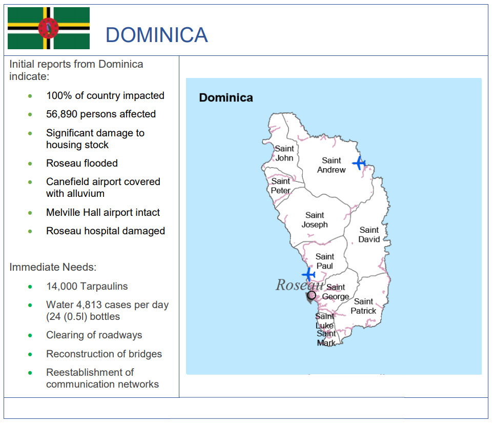
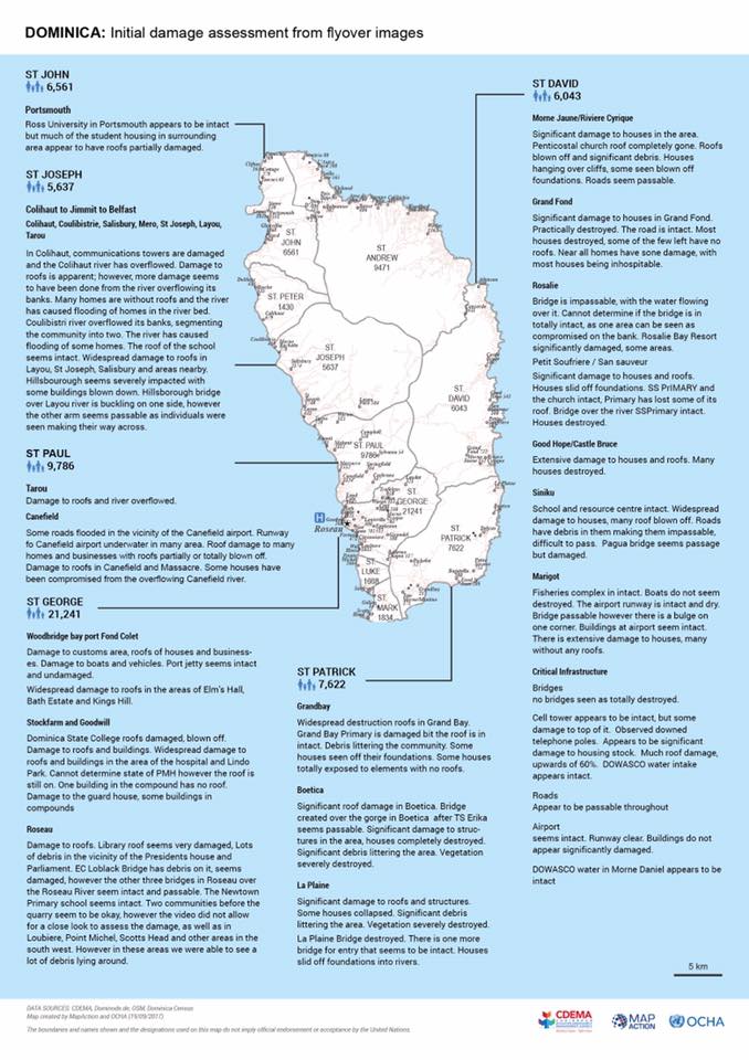
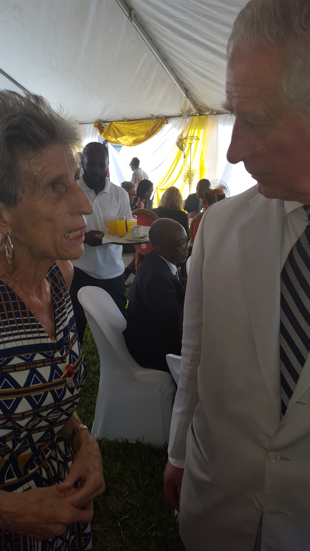
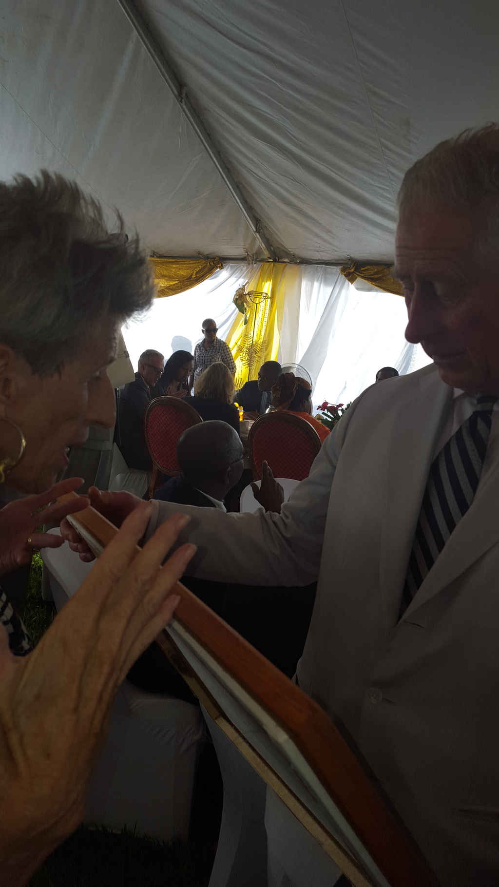
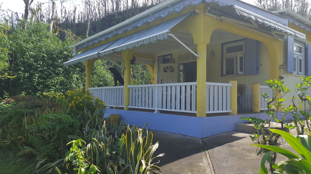
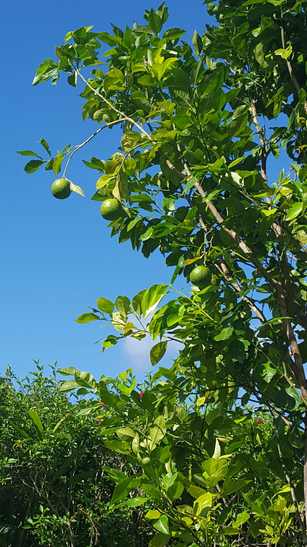
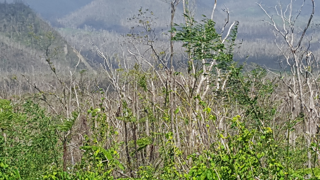
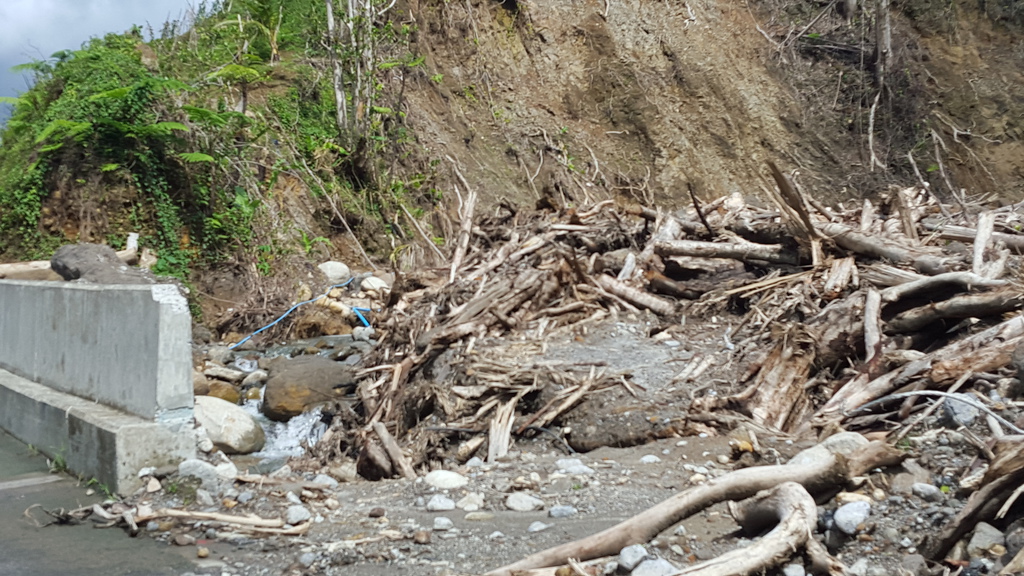
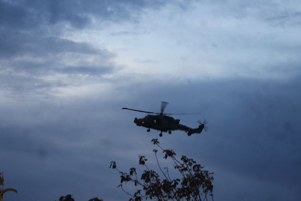
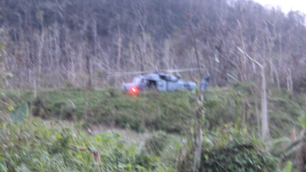
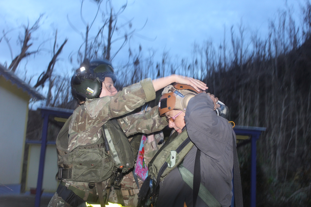
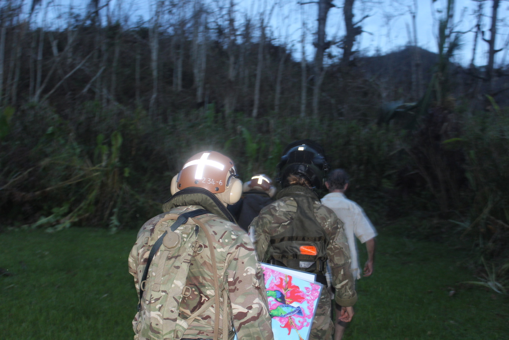
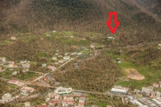