|
|
- - - 2018 Hurricane Season - - -
|
- Dry Season
|
- By Frank Goodwill <nevis.storm at hotmail.com>
- Date: Sat, 2 Mar 2019 19:21:51 +0000
|
Good day all,
Add the dry season begins to bite the Nevis Water Department introduced water rationing (at night) on 22nd February 2019:
The General Public is ask to take note of the following measures relating to the dry spell currently being experienced. The Water Department has implemented a water rationing schedule which will continue in the following areas:-
Butlers, Bricklyn, Potworks, Lower Westbury, Zion Village, Hanley’s Road, Hickmans, Rices, Victoria Road, Upper Church Ground, Braziers, Upper Hamilton, Upper Ramsbury, Craddock Road, Cherry Gardens, Prospect, Bath Village, Lower Ramsbury, Charlestown.
This interruption will occur between 9:00 PM and 4:00 AM
Persons are also urged to exercise ALL water conservation practices such as; re-using recycled waters for lawns, monitor domestic water use in the home which includes bath, brushing teeth, washing of dishes and utilizing water from rain water
storage cisterns.
The Nevis Water Department do apologize for the inconvenience this may cause.
-----------------------------------------------------------------------
The forecast for the coming week reinforces the 'dry' theme to the weather.
"Dry and stable conditions continue across the region leading to low chances for cloudiness and showers over the next few days."
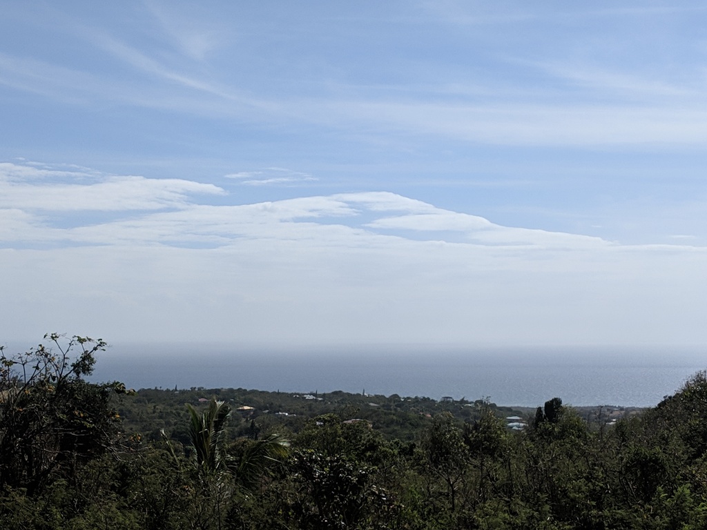
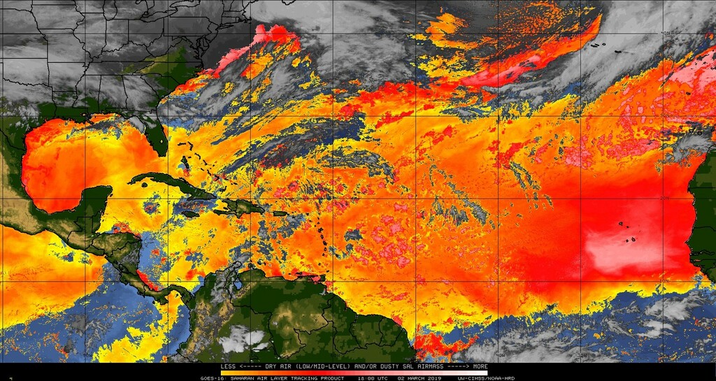
The view today is a little hazy and it seems that the 'Saharan Dust' is back with us. See attached.
Enjoy your weekend,
Frank Goodwill
Pond Hill Weather Station and Cam.
https://www.wunderground.com/personal-weather-station/dashboard?ID=ISAINTGE361
|
|
- February Weather Station report
|
- By "Harry W. Hallstrom" <hwh888 at gmail.com>
- Date: Fri, 1 Mar 2019 17:35:04 -0400
|
Greetings All,
Attached station data for February in NOAA format for those interested.
Attachment:
Feb 2019 NOAA Weather Date.pdf
Description: Adobe PDF document
|
|
- Bright and Breezy
|
- By Frank Goodwill <nevis.storm at hotmail.com>
- Date: Tue, 19 Feb 2019 12:58:09 +0000
|
Good morning all,
We are in the "dry season" so things are pretty quite weatherwise. No oddball out of season storms either, so far.
Weather for the week will be affected by a strengthening high pressure ridge. This will tighten the pressure gradient across the area and will result in increased winds as well as elevated seas. In addition, shallow pockets
of low level moisture embedded within the wind flow could result In a moderate chance for showers by Thursday into Friday.
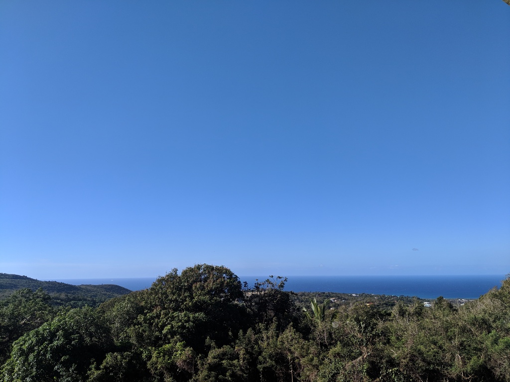
A couple of morning views attached from Nevis to brighten your day.
Regards,
Frank Goodwill
Pond Hill Weather Station and Weather Cam
https://www.wunderground.com/personal-weather-station/dashboard?ID=ISAINTGE361

|
|
- January NOAA Weather Data
|
- By "Harry W. Hallstrom" <hwh888 at gmail.com>
- Date: Mon, 11 Feb 2019 06:40:32 -0400
|
Greetings All,
Attached weather station download data for January 2019 for those interested.
Attachment:
Jan 2019 - NOAA Weather Data.pdf
Description: Adobe PDF document
|
|
- Cool, Misty, Drizzle
|
- By Frank Goodwill <nevis.storm at hotmail.com>
- Date: Tue, 29 Jan 2019 20:08:59 +0000
|
|
Good afternoon all,
Not a tourist authority ideal day today. From midday it has been cool (23.8C - Post Brexit 74.8F), with varying low level cloud and drizzle. Well it is for us in the Nevis Peak foothills!
Photos attached.
Interesting weather forecast from Antigua Met Services for St. Kitts and Nevis today:
"Relatively dry and stable conditions throughout the atmospheric column will keep shower activity across the area to a minimum for the forecast period.
Weather today: Partly sunny with a 30 percent or low chance of showers."
Well you never know😀
Regards,
Frank Goodwill
Pond Hill, Nevis Weather Station
Outlook for Android
|
|
- Bright and Breezy
|
- By Frank Goodwill <nevis.storm at hotmail.com>
- Date: Sat, 26 Jan 2019 16:57:45 +0000
|
Good day all,
A sunny Saturday with a strong breeze blowing here in Nevis. This is due to a strong Atlantic high pressure system that will continue to generate high winds and elevated seas over next couple of days. The relatively strong wind flow will transport
pockets of low level moistiure across the area. These conditions will result in a moderate chance of brief showers during the next few days. Some of the showers could be locally heavy at times accompanied by gusty winds.
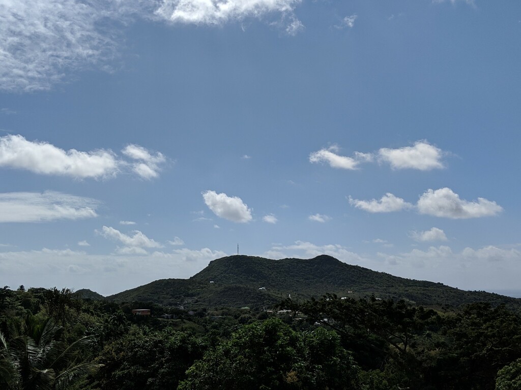
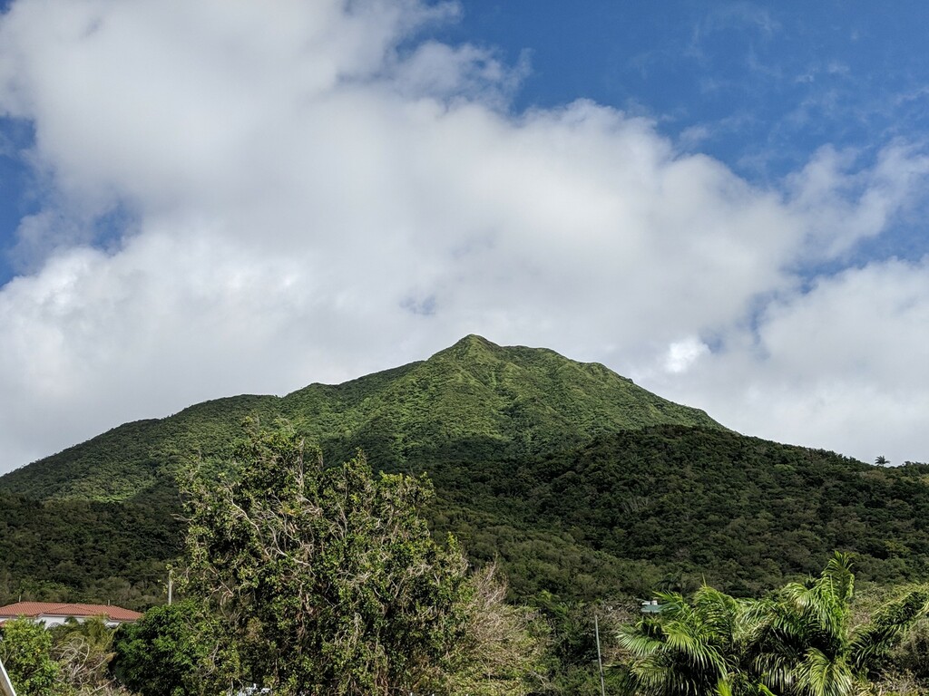
Still looks good though - see attached.
Regards,
Frank Goodwill
Pond Hill Weather Station
https://www.wunderground.com/personal-weather-station/dashboard?ID=ISAINTGE361

|
|
- Bright and Breezy
|
- By Frank Goodwill <nevis.storm at hotmail.com>
- Date: Sat, 26 Jan 2019 16:51:23 +0000
|
Good day all,
A sunny Saturday with a strong breeze blowing here in Nevis. This is due to a strong Atlantic high pressure system that will continue to generate high winds and elevated seas over next couple of days. The relatively strong wind flow will transport
pockets of low level moistiure across the area. These conditions will result in a moderate chance of brief showers during the next few days. Some of the showers could be locally heavy at times accompanied by gusty winds.
Still looks good though - see attached.
Regards,
Frank Goodwill
Pond Hill Weather Station
https://www.wunderground.com/personal-weather-station/dashboard?ID=ISAINTGE361

|
|
- Forecast of Wind and Showers
|
- By Frank Goodwill <nevis.storm at hotmail.com>
- Date: Mon, 21 Jan 2019 18:52:06 +0000
|
Good day everyone,
Sunday and .Monday (today) has been mainly overcast with some short sharp showers or drizzle. As it is 'winter' here, nighr time temperatures have been as low as 22C (low 70'sF) at my location.
Later on in the week some further showers and windy weather is forecast.
A high pressure system is the dominant weather feature for the week. As the high moves closer to the islands, there will be an increase of wind speeds as the pressure gradient steepens.
Starting Tuesday, a moderate to fresh breeze will be generated. This will probably result in sea conditions becoming hazardous for mariners and small craft operators beginning late Wednesday and for beachgoers beginning Thursday.
Warnings and Advisories will be issued for the respective periods as required. An increase in brief shower downpours are also possible beginning Tuesday as the winds transport pockets of moisture across the area.
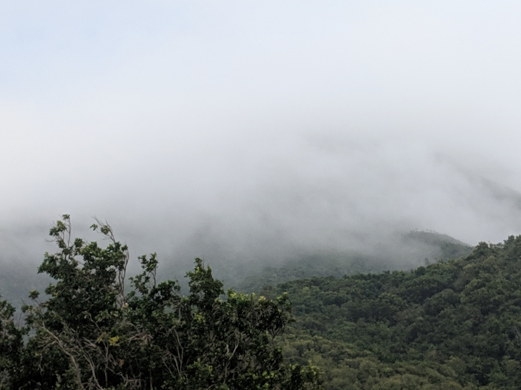
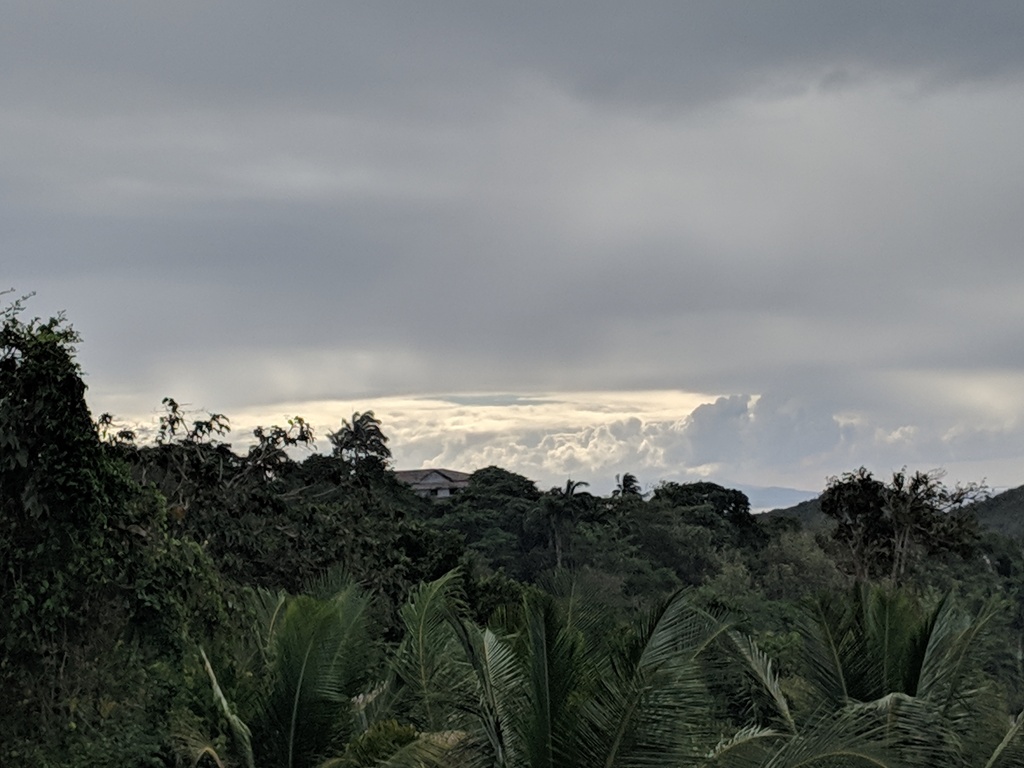
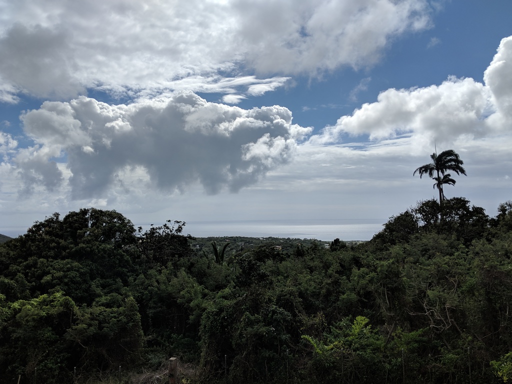
A few pictures of the weather this morning on Nevis.
I've added a webcam to the old weather station. Link via the weather station and Wunderground is below
Regards,
Frank Goodwill
Pond Hill weather station.
https://www.wunderground.com/personal-weather-station/dashboard?ID=ISAINTGE361
|
|
- December 2018 NOAA Weather Data
|
- By "Harry W. Hallstrom" <hwh888 at gmail.com>
- Date: Wed, 2 Jan 2019 11:42:44 -0400
|
Greetings & a Happy Healthy New Year to all,
Attached the monthly weather data from station for Nevis. In NOAA format for those interested.
Attachment:
Dec 2018 - NOAA Weather Data.pdf
Description: Adobe PDF document
|
|
- Rough seas offshore............
|
- By "Harry W. Hallstrom" <hwh888 at gmail.com>
- Date: Sat, 29 Dec 2018 17:02:30 -0400
|
Greetings All,
A short clip from NHC about sea conditions in the offshore waters around Nevis & the Leewards Continuing into Monday before moderating a bit. Mariners beware.
AMZ025-300815-
Offshore Waters Leeward Islands-
312 PM EST Sat Dec 29 2018

.TONIGHT...NE to E winds 20 to 25 kt. Seas 7 to 11 ft in NE to E swell.

.SUN...NE to E winds 20 to 25 kt. Seas 7 to 11 ft in NE to E swell.
.SUN NIGHT...NE to E winds 15 to 20 kt. Seas 7 to 10 ft in NE to E swell.

.MON...NE to E winds 15 to 20 kt. Seas 6 to 9 ft in NE to E swell.
.MON NIGHT...NE to E winds 15 to 20 kt. Seas 5 to 7 ft.

.TUE...NE to E winds 15 to 20 kt. Seas 5 to 7 ft.
.TUE NIGHT...NE to E winds 15 to 20 kt. Seas 4 to 6 ft.

.WED...E winds 15 to 20 kt. Seas 5 to 7 ft.
.WED NIGHT...E winds 15 to 20 kt. Seas 5 to 7 ft.

.THU...E winds 15 to 20 kt. Seas 5 to 7 ft.
.THU NIGHT...E winds 15 to 20 kt. Seas 5 to 7 ft.
|
|
- Windy and Rough Seas
|
- By Frank Goodwill <nevis.storm at hotmail.com>
- Date: Fri, 28 Dec 2018 11:51:57 +0000
|
|
Good morning all,
I hope you all had a Merry Christmas. As we head for the new year, high pressure near the Caribbean is giving some strong wind flow over the area today, Friday and into the weekend. Some strong winds and rough seas are to be expected.
See the link following for details:
Regards,
Frank Goodwill
Pond Hill, Nevis Weather Station
Outlook for Android
|
|
- Nov NOAA weather data attached
|
- By "Harry W. Hallstrom" <hwh888 at gmail.com>
- Date: Sun, 2 Dec 2018 02:11:51 -0400
|
For those interested, see attached pdf file.
Attachment:
Nov 2018 - Weather Data.pdf
Description: Adobe PDF document
|
|
- Gloomy Weather for Leewards
|
- By "Harry W. Hallstrom" <hwh888 at gmail.com>
- Date: Tue, 13 Nov 2018 07:21:25 -0400
|
Greetings All,
Dreary, rainy weather in store for next several days with this slow moving depression hanging around the Leewards. We are buried in the image below. NHC says we can expect locally heavy rains at times.
|
|
- Extended Forecast
|
- By "Harry W. Hallstrom" <hwh888 at gmail.com>
- Date: Sun, 11 Nov 2018 06:34:32 -0400
|
Greetings All,
The extended forecast doesn't look good the the coming week. We've been sort of stuck in a cloudy not to sunny weather pattern for several days now. Not always rain but not much sun either.
Some new/revised weather station links............
1. Direct link to station data
2. Wunderground link
|
|
- Fwd: Weatherlink new
|
- By "Harry W. Hallstrom" <hwh888 at gmail.com>
- Date: Mon, 5 Nov 2018 20:45:35 -0400
|
Greetings All,
WeatherLink Change...........
There has been a software change to the link I provided to my station. Belolw are two new links.
Map: Will display a world map with all Davis Weather Station available to monitor. Station: Is the direct link to read my station. data.
|
|
- Oct 2018 NOAA Weather Date
|
- By "Harry W. Hallstrom" <hwh888 at gmail.com>
- Date: Fri, 2 Nov 2018 08:21:39 -0300
|
Greetings All,
Attached weather data for month of October for Nevis. A pdf file formatted in NOAA format.
Attachment:
Oct 2018 NOAA Weather Data.pdf
Description: Adobe PDF document
|
|
- Change - Finally
|
- By "Harry W. Hallstrom" <hwh888 at gmail.com>
- Date: Sun, 21 Oct 2018 09:32:25 -0400
|
|
Greetings All,
Seems we’ve turned the corner and are into “fall” weather? Much nicer temperatures and lower humidity. After a brutal hot humid summer I totally welcome the change.
Next project is to compare summer time past temperatures with 2018 and last. It seems of late, many months with temps well into the mid-upper 90’s, which I don’t remember being that warm 15-20 years ago.
Climate change??
Harry --
Sent via IPhone.
|
|
- Sunny with Clouds
|
- By Frank Goodwill <nevis.storm at hotmail.com>
- Date: Fri, 12 Oct 2018 00:25:16 +0000
|
|
Good night all,
The 2018 hurricane season has been categorised as above average. Luckily the North Eastern Caribbean has missed all of the destructive action so far.
"Leslie" continues its wanderings in the Eastern Atlantic heading towards Africa before weakening and turning around again.
"Michael" after its visitation on the USA is getting ready to gallop across the Atlantic and head towards Europe (France/Spain)
"Nadine" is being pulled apart by wind shear mid-Atlantic and is forecast to degenerate into a trough of low pressure within 48 hours.
So still busy out there.
Locally the weather is quiet with partial cloud and sunny periods. An upper level low pressure area is forecast to develop over the western Caribbean and will move towards the Leeward Islands during the weekend. This would result in an increase of medium and
high level clouds. Additionally, a weak tropical wave is forecast to combine with this trough and bring with it an increased chance of showers during the weekend.
Digicel's Caribbean Cable TV and internet has suffered a major outage since 8pm Wednesday night so my weather station hasn't been reporting to Wunderground via the internet.
Regards,
Frank Goodwill
Pond Hill, Nevis Weather Station
Outlook for Android
|
|
- Tropical Storm Nadine
|
- By "Harry W. Hallstrom" <hwh888 at gmail.com>
- Date: Wed, 10 Oct 2018 08:17:49 -0400
|
Greetings All,
Just read the data on Nadine and it appears it will drift NNW into the Atlantic and dissipate. Three days out (from today 5am) it will travel on a 300 degree path putting it 1600 miles away from Nevis.
Doesn't pose any threat to Nevis/St. Kitts.
|
|
- All Quiet In These Parts
|
- By Frank Goodwill <nevis.storm at hotmail.com>
- Date: Sat, 6 Oct 2018 02:47:45 +0000
|
|
Good night all,
The weather this week has been sunny, hazy with periods of cloud and an isolated shower or two.
At the moment the presence of a weak upper level trough combined with available low level moisture, will result in a moderate chance of showers over the next few days. By Tuesday a weak tropical wave will increase the chance of shower activity.
Regards,
Frank Goodwill
Pond Hill, Nevis Weather Station
Outlook for Android
|
|
- Sept Weather Data
|
- By "Harry W. Hallstrom" <hwh888 at gmail.com>
- Date: Mon, 1 Oct 2018 08:15:34 -0400
|
Greetings All,
Attached September's NOAA formatted weather data for Nevis for those interested.
Complained all month how hot it was, here is the report. Looking forward to a cool down...........
Attachment:
Sep 2018 - NOAA Weather Data.pdf
Description: Adobe PDF document
|
|
- A Little Wet!
|
- By Frank Goodwill <nevis.storm at hotmail.com>
- Date: Sat, 29 Sep 2018 02:00:24 +0000
|
|
Good night all,
It looks as if we are feeling the effects of a long length of rain cloud moving up from the ESE.
No strong winds just light rain from 5pm until 9:30pm. So far, up in the Nevis Peak foothills, we have had 15mm (0.6 in) of rain. At 5pm there was also a sudden drop in temperature as the sky darkened.
No earthquakes or strong winds! Though we do need the rain.
The temperature reading on the old weather station rises by 10c+ when it rains. Everything else is working ok. This is a known problem and is due to damp getting into the temp sensor circuit board. Waiting for a couple of "bits" to fix it.
The weather for the weekend into Mondsy
Lingering moisture and instability across the area is expected to generate some unsettled conditions on Saturday. From Sunday a ridge of high pressure will move in to restrict any significant shower activity. Rough sea conditions will effect the coast on the
Windward (Atlantic) side of the island on Saturday.
Regards,
Frank Goodwill
Pond Hill, Nevis Weather Station
Outlook for Android
|
|
- Isaac? NO Kirk
|
- By "Harry W. Hallstrom" <hwh888 at gmail.com>
- Date: Fri, 28 Sep 2018 09:08:42 -0400
|
Greetings All,
Wow, how did I mix them up? For sure meant to say KIRK.
Thank you to the caller from St. Thomas for calling me right away.
|
|
- Isaac Fri 7 am
|
- By "Harry W. Hallstrom" <hwh888 at gmail.com>
- Date: Fri, 28 Sep 2018 08:52:16 -0400
|
Greetings All,
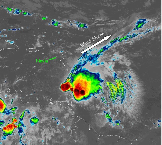
A 7am image of whats happening with Isaac. Wind sheer is pushing those rain bands out away from Nevis, they may eventually catch up to us as as Isaac moves westward. Right now out the window we vacillate between sun and high thin clouds, no rain, very little wind.
|
|
- Storm Isaac & Nevis
|
- By "Harry W. Hallstrom" <hwh888 at gmail.com>
- Date: Wed, 26 Sep 2018 13:25:48 -0400
|
Greetings All,
Just had a chance to analyze National Hurricane Data read for 11 am and here are my observations.
Projected path at present is moving in a slightly more that West direction at 280 degrees now. The projected path extending out 36 - 48 hours calculates out slightly more at 290 degrees.
Based on present location and projected path Isaac will pass over southern tip of Martinique. Moving at a 290 degree path will put Isaac about 140 miles SSW at neatest point to Nevis, that would be Fri 11 am time frame.
Wind speed probabilities for a 34 kt wind over Nevis are very low, in the 2% - 7% category. Rain patterns, not so sure about what rain we will receive?
NHC says 4-6 inches possible across the southern Leeward islands. That would mean less for our area.
Will post again tomorrow between 11 am or the 5 pm data read from NHC.

|
|
- Kirk - He's Back.
|
- By Frank Goodwill <nevis.storm at hotmail.com>
- Date: Wed, 26 Sep 2018 10:06:45 +0000
|
|
Good morning all,
It looks as if 'Kirk' has managed to get itself organised again as a Tropical Storm for a while.
More of a problem for Barbados and the Windward Islands with maximum sustained winds of 45 mph with stronger gusts.
A Tropical Storm Warning is in effect for...
* Barbados
* St. Lucia
A Tropical Storm Watch is in effect for...
* St. Vincent and the Grenadines.
With stronger windflower to the north of 'Kirk' Nevis will probably experience some squally showers on Thursday into Friday. Sea conditions will be rougher over the two days as the system passes by.
Regards,
Frank Goodwill
Pond Hill, Nevis Weather Station
Outlook for Android
|
|
- Kirk Dissipates.
|
- By Frank Goodwill <nevis.storm at hotmail.com>
- Date: Mon, 24 Sep 2018 15:19:51 +0000
|
Good morning,
As of 11am today the US National Hurricane Center is showing that Kirk has dissipated to become an "active" Tropical Wave.
It may resurrect itself, but various environmental issues may make this challenging.
Regards,
Frank Goodwill
https://www.wunderground.com/personal-weather-station/dashboard?ID=ISAINTGE361

|
|
- TS Kirk Down To A Depression at 11pm
|
- By Frank Goodwill <nevis.storm at hotmail.com>
- Date: Mon, 24 Sep 2018 03:40:01 +0000
|
Good night all,
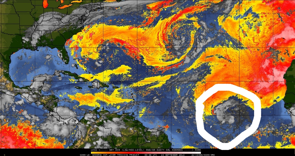
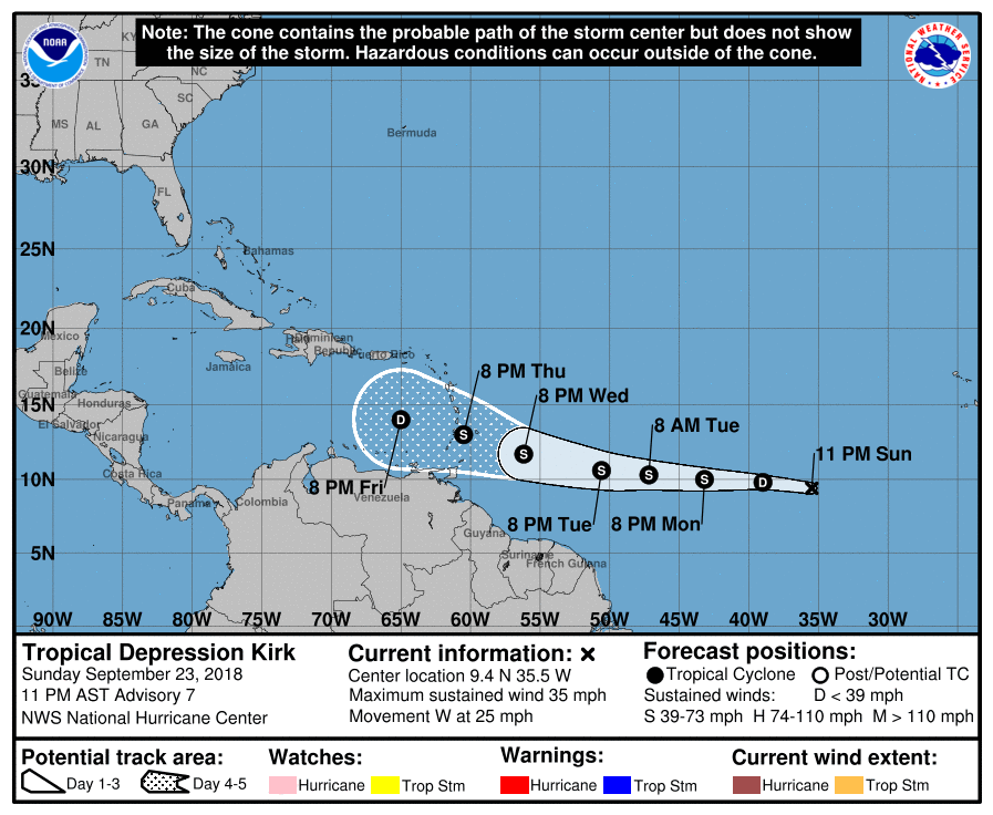
TS Kirk is now back down to a Tropical Depression as it wades though some dry air from the Saharan Air Layer.
Low latitude and fast movement west near 25 mph (41 km/h) is also working against development. Maximum sustained winds have decreased to near 35 mph (55 km/h) with higher gusts.
The rapid westward motion is anticipated for the next day or two.
A slight decrease in forward motion is expected by mid-week. Warm Sea Surface Temperatures (SST) can help strengthen Kirk, but it may hit the wind shear later in the week that dissipated TD11. It is also possible that Kirk could degenerate into
a trough of low pressure.
So it will be interesting to see how Kirk will play out over the coming week.
Meanwhile back at the ranch in Nevis, the remnants of Depression 11 will increase the chance of showers during Monday night. On Wednesday, the passing of a weak tropical wave is also forecast to bring an increase in clouds and showers.
Regards
Frank Goodwill
https://www.wunderground.com/personal-weather-station/dashboard?ID=ISAINTGE361
|
|
- TS Kirk Info
|
- By "Harry W. Hallstrom" <hwh888 at gmail.com>
- Date: Sat, 22 Sep 2018 11:45:41 -0400
|
Greetings All,
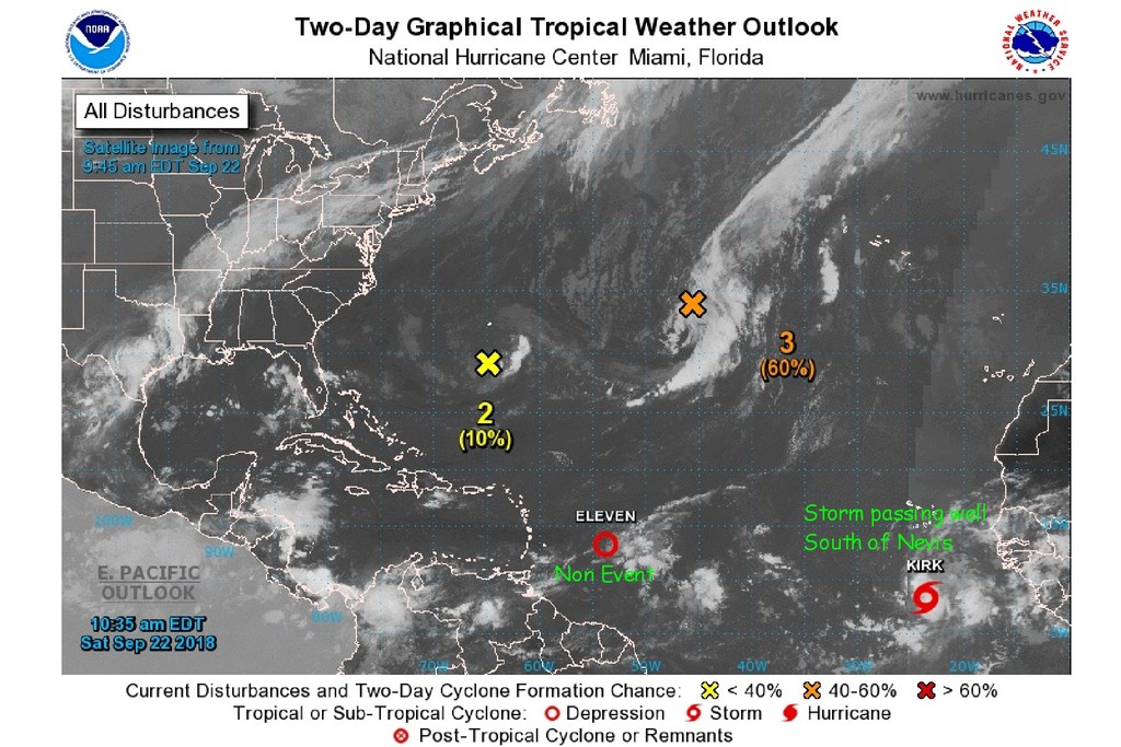
Another look at weather and the depression forming off coast of Africa is now a named storm, "KIRK"
Several days away and tracking well south of Nevis.
More in the vicinity of St. Vincent/Barbados area with 45 mph winds.
Will have another look in 2-3 days.
|
|
- We Now Have TS Kirk
|
- By Frank Goodwill <nevis.storm at hotmail.com>
- Date: Sat, 22 Sep 2018 15:21:02 +0000
|
|
Good morning all,
"At 1100 AM AST (1500 UTC), the center of Tropical Storm Kirk was
located near latitude 8.3 North, longitude 23.6 West. Kirk is moving toward the west near 14 mph (22 km/h) and a westward to west-
northwestward motion at a similar forward speed is expected to continue through tonight. A faster westward motion across the deep tropical Atlantic Ocean is expected Sunday through Tuesday.
Maximum sustained winds are near 40 mph (65 km/h) with higher gusts. Some strengthening is forecast through Sunday, with little change in intensity forecast on Monday and Tuesday."
TS Kirk is moving westward fairly fast which is slightly hindering development. Early days to judge intensity and where it will pass over the islands.
One that needs to be watched.
Tropical Depression 11 near the Windwards Islands is slow moving and is still forecast to dissipate before reaching the islands.
Regards,
Frank Goodwill
Pond Hill, Nevis Weather Station
Outlook for Android
|
|
- Which One?
|
- By "Harry W. Hallstrom" <hwh888 at gmail.com>
- Date: Fri, 21 Sep 2018 06:56:36 -0400
|
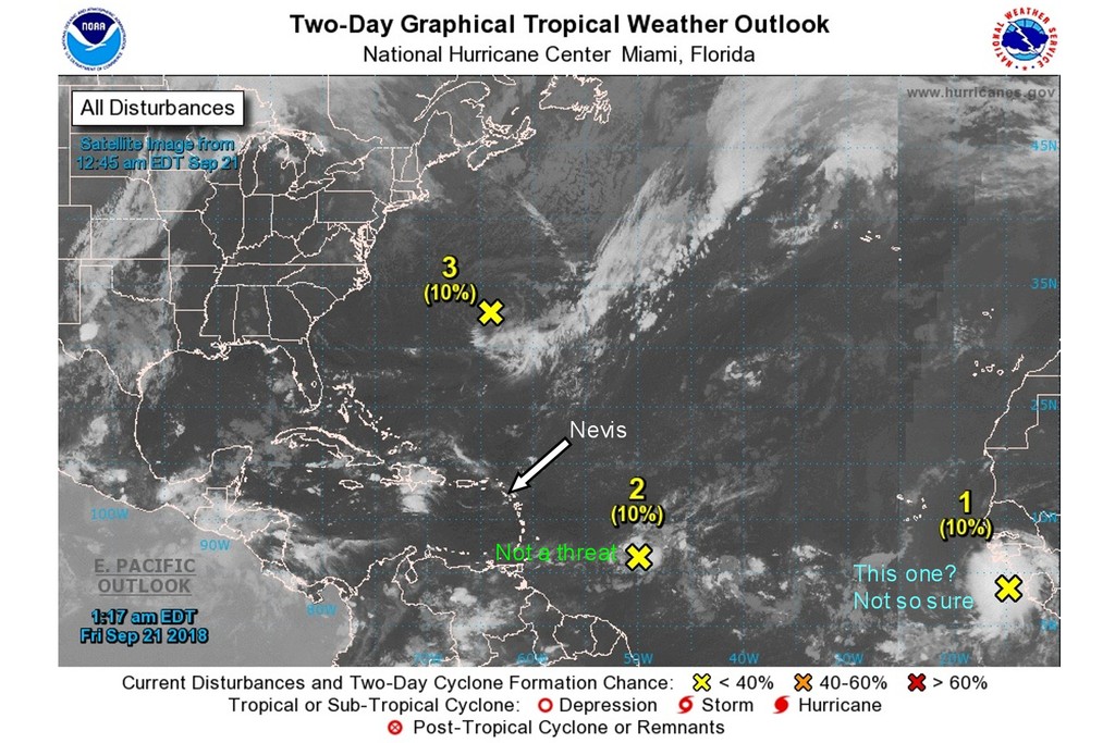
Sorry, referring to disturbance #1
|
|
- Latest NHC Images
|
- By "Harry W. Hallstrom" <hwh888 at gmail.com>
- Date: Fri, 21 Sep 2018 06:53:23 -0400
|
Greetings All,
Having a look at images from space & the National Hurricane Center along with my comments......... The second one just off coast of Africa looks threatening?
Much to early to say what will happen but will watch it for the next several days.
|
|
- A Weak Wave, Dust and a New Disturbance.
|
- By Frank Goodwill <nevis.storm at hotmail.com>
- Date: Wed, 19 Sep 2018 08:00:15 +0000
|
Good night all,
A weak tropical wave is approaching the Islands. It will trigger brief cloudiness across the Islands with a moderate chance of showers.
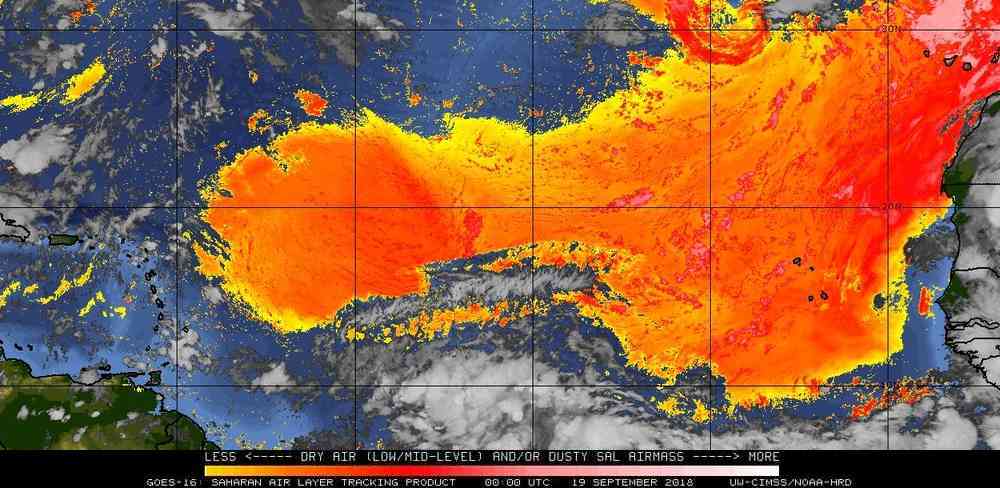
Meanwhile hazy conditions will reduce air quality over the next few days. A large Saharan Dust plume is moving over the Atlantic, so that is not surprising.
(See attached)
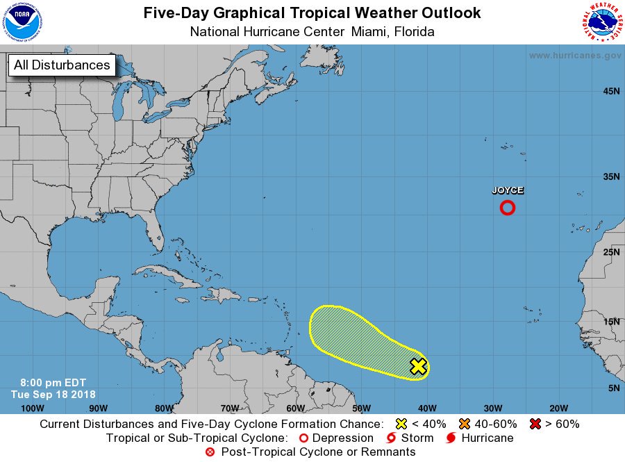
Meanwhile the US National Hurricane Center has started to monitor a new disturbance.
(Graphic is attached)
"A large area of disturbed weather has developed in association with a tropical wave located about 1300 miles east-southeast of the Lesser Antilles. Environmental conditions are expected to be somewhat conducive for some slow development of
this system through Friday while it moves west-northwestward at 10 to 15 mph. Over the weekend, however, upper-level winds are expected to become unfavorable for tropical cyclone formation to occur.
* Formation chance through 48 hours...low...10 percent.
* Formation chance through 5 days...low...20 percent."
Regards,
Frank Goodwill
&
ttps://www.wunderground.com/personal-weather-station/dashboard?ID=ISAINTGE361
|
|
- Back To Normal
|
- By Frank Goodwill <nevis.storm at hotmail.com>
- Date: Sun, 16 Sep 2018 04:45:27 +0000
|
|
Good night all,
The US National Hurricane Center is forecasting that the remnant of Isaac may resurrect itself - a 20% chance for both 48 hour and 5 day forecasts. It may be thwarted by hostile environment conditions.
No threat to us as it moves in a North Westerly direction over Jamaica.
As for the weather on Nevis, the next few days will be dominated by a light south easterly wind flow. In addition, daytime heating and an already unstable atmosphere may result in a moderate chance of localised shower activity, mainly during the afternoons.
By Wednesday a tropical wave is expected to move into the area and will result in a higher chance of showers.
Some showers would be good as it is still pretty dry here despite the rain Isaac gave us (which was not that much).
Saturday was dry but a mostly cloudy day on Nevis.
Regards,
Frank Goodwill
Pond Hill, Nevis Weather Station
Outlook for Android
|
|
- TS Isaac Update 5pm
|
- By Frank Goodwill <nevis.storm at hotmail.com>
- Date: Thu, 13 Sep 2018 22:03:53 +0000
|
Good afternoon all,
All watches and warnings have been discontinued for TS Isaac at 5 pm.
In Nevis the wind speed and gusts have reduced over the last hour. It looks like some rain bands following on behind Isaac, so we will see what rain we get overnight.
Regards,
Frank Goodwill
https://www.wunderground.com/personal-weather-station/dashboard?ID=ISAINTGE361
Attachment:
20180913 1700.jpg
Description: 20180913 1700.jpg
Attachment:
204328_5day_cone_no_line_and_wind.png
Description: 204328_5day_cone_no_line_and_wind.png
|
|
- TS Isaac Update 2 pm
|
- By Frank Goodwill <nevis.storm at hotmail.com>
- Date: Thu, 13 Sep 2018 18:43:28 +0000
|
Good afternoon all,
It is still pretty breezy here up in the Nevis Peak foothills. Measured sustained wind is recorded at 25 mph (41 km/h) with gusts measured at 37 mph (60 km/h).
It has remained pretty dry so far with only a few brief light showers. This may change as heavy showers are forecast later as moist air following Isaac moves over us.
Isaac is becoming less organised as it moves over the Caribbean Sea to the south of Nevis.
As well as local Government Offices and schools being closed today. On Nevis, Federal Goverbment Offices (St. Kitts) will close from 1:30 pm
https://sknis.kn/federal-government-offices-except-essential-services-will-close-today-at-130pm-due-to-impending-passage-of-tropical-storm-isaac
Inter-island ferry services have also been disrupted with many services not running.
* ETSI (Express & Next Edition) WILL NOT be running
* Mark Twain & Sea Hustler WILL NOT be running.
* Caribe Surf/Breeze WILL NOT be running.
* Water Sports Islander WILL NOT be running.
* BluWaves WILL NOT be running.
* Apple Syder WILL BE RUNNING - SCHEDULE UNCERTAIN Charlestown to Port Zante Marina.
* Paradise Sun Charters WILL BE RUNNING - Oualie to/from Reggae Beach
* SEA BRIDGE IS EXPECTED TO RUN
This can be subject to change.
Added to this we haven't suffered any NEVLEC power outages in this area of Nevis - so far.
Regards,
Frank Goodwill
https://www.wunderground.com/personal-weather-station/dashboard?ID=ISAINTGE361
Attachment:
174712_5day_cone_no_line_and_wind.png
Description: 174712_5day_cone_no_line_and_wind.png
Attachment:
IMG_20180913_143932.jpg
Description: IMG_20180913_143932.jpg
|
|
- TS Isaac Update
|
- By Frank Goodwill <nevis.storm at hotmail.com>
- Date: Thu, 13 Sep 2018 14:55:12 +0000
|
Good morning all,
A little breezy this morning and overcast with some hazy sunshine breaking through.
Up in the Nevis Peak foothills I have measured sustained winds of 27 mph (36 km/h) with maximum gusts of up to 37mph (60 km/h) so far.
These are probably higher than elsewhere on the island due to being 900 feet above sea level.
We have experienced a couple of short light showers this morning. Looking at the Guadeloupe rain radar most of the shower activity is to the south of Nevis.
Government offices and schools in Nevis are closed today.
Data from a NOAA Hurricane Hunter aircraft, indicates that maximum sustained winds are near 45 mph (75 km/h) with higher gusts. Little change in strength is expected over the next several hours as Isaac moves into the Caribbean Sea.
Regards,
Frank Goodwill
https://www.wunderground.com/personal-weather-station/dashboard?ID=ISAINTGE361
Attachment:
20180913 0700.jpg
Description: 20180913 0700.jpg
Attachment:
Screenshot_20180913-1014335_20180913102307098.jpg
Description: Screenshot_20180913-1014335_20180913102307098.jpg
Attachment:
144134_5day_cone_no_line_and_wind.png
Description: 144134_5day_cone_no_line_and_wind.png
|
|
- Isaac Thursday 5 am
|
- By "Harry W. Hallstrom" <hwh888 at gmail.com>
- Date: Thu, 13 Sep 2018 06:31:56 -0400
|
Greetings All,
Seems like Isaac is getting ripped apart with wind sheer and the likes. Satellite images show very little left as a recognizable tropical storm. NHC says.......... Isaac is nearly completely devoid of deep convection at the moment,
and is not trackable in radar data from Guadeloupe and Martinique.
Given the lack of deep convection to sustain the cyclone, continued
gradual weakening is expected.
Currently out the window it looks like "just another day on Nevis"
Some wind, no rain and a rising sun.
|
|
- TS Isaac still - 2pm
|
- By Frank Goodwill <nevis.storm at hotmail.com>
- Date: Wed, 12 Sep 2018 18:36:05 +0000
|
Good afternoon all,
TS Isaac has picked up a little speed at 21 mph (33 km/h) as it moves westwards. The US National Hurricane Center continues to categorise Isaac as s Tropical Storm. Looking at a recent satellite picture it looks s bit of a mess, lacking clear
definition (see attached).
Aircraft data indicate that maximum sustained winds remain near 60 mph (95 km/h) with higher gusts. Gradual weakening continues to be forecast during the next 72 hours.
Tropical Storm force winds extend outward up to 175 miles (280 km), primarily to the north of the center.
Up in the Nevis Peak foothills showers continue and have measured over half an inch (15.6 mm) of rain so far today.
The wind has remained variable and squally during showers.
Regards,
Frank Goodwill
https://www.wunderground.com/personal-weather-station/dashboard?ID=ISAINTGE361
Attachment:
IMG_20180912_141407.jpg
Description: IMG_20180912_141407.jpg
Attachment:
175639_5day_cone_no_line_and_wind.png
Description: 175639_5day_cone_no_line_and_wind.png
|
|
- TS Isaac
|
- By Frank Goodwill <nevis.storm at hotmail.com>
- Date: Wed, 12 Sep 2018 16:04:37 +0000
|
Good morning all,
At 1100 AM AST (1500 UTC), the center of Tropical Storm Isaac was located by a NOAA Hurricane Hunter aircraft near latitude 15.0 North, longitude 54.7 West. Isaac is moving toward the west near 17 mph (28 km/h), and this general motion with
some decrease in forward is expected to continue through the weekend.
Isaac is forecast to move across the central Lesser Antilles and into the eastern Caribbean Sea on Thursday, and then move across the eastern and central Caribbean Sea through Saturday. Aircraft data indicates that the maximum sustained winds
remain near 60 mph (95 km/h) with higher gusts. Gradual weakening is forecast during the next 72 hours.
A point to note is that Tropical Storm force winds associated with Isaac extend outward up to 175 miles (280 km), primarily to the north of the centre. So though Isaac is weakening there is a good chance we in Nevis may experience some wind
speeds in the low 30's mph (50's kph).
The wind is variable but running at about 22.5 kph (14 mph) at just after 11am.
So far up in the Nevis Peak foothills rainfall has registered about 12.95mm (Half an inch) from showers today.
Regards,
Frank Goodwill
https://www.wunderground.com/personal-weather-station/dashboard?ID=ISAINTGE361
Attachment:
20180912-1135.png
Description: 20180912-1135.png
|
|
- Nevis Weather Station link to live report
|
- By "Harry W. Hallstrom" <hwh888 at gmail.com>
- Date: Wed, 12 Sep 2018 09:11:07 -0400
|
Greetings All,
You can follow this link to get updated weather every few minutes, as long as I have internet service.
|
|
- TS Isaac approaches but has weakened slightly.
|
- By Frank Goodwill <nevis.storm at hotmail.com>
- Date: Wed, 12 Sep 2018 12:14:21 +0000
|
Good morning all,
We have had a couple of early morning showers as rain bands from Isaac start to pass over us. See attached picture from the Guadeloupe rada - St. Kitts and Nevis are located on the top left corner.
Also the wind is picking up this morning especially during showers. See attached graphic.
Isaac continues to weaken as it approaches the islands. Maximum sustained winds have decreasd to near 60 mph (95 km/h) with higher gusts. Gradual weakening is forecast during the next few days. This weakening has been due to windshear.
Isaac is expected to produce total rainfall accumulations of 2 to 4 inches with isolated amounts up to 8 inches across Martinique, Dominica, and Guadeloupe. Up to one inch is anticipated across the remaining Windward and Leeward Islands.
A NOAA hurricane hunter aircraft is scheduled to investigate Isaac later this morning and should provide a better assessment of the intensity of the tropical storm and the extent of its winds.
St Kitts and Nevis continues to be under a Tropical Storm Watch.
Regards
Frank Goodwill
https://www.wunderground.com/personal-weather-station/dashboard?ID=ISAINTGE361
Attachment:
Screenshot_20180912-073237_crop_346x409.png
Description: Screenshot_20180912-073237_crop_346x409.png
Attachment:
wind 20180912-075613.png
Description: wind 20180912-075613.png
|
|
- Storm Isaac - Thursday 5 am data
|
- By "Harry W. Hallstrom" <hwh888 at gmail.com>
- Date: Wed, 12 Sep 2018 08:10:29 -0400
|
Greetings All,
The 5 am NHC data puts Isaac's location approx 600 miles SE of Nevis. Strength has NOT increased, present winds at 60 mph close to the center of storm. This decreases the further away one moves from center of storm. Note this is a storm not a hurricane. Winds need to be sustained at 75 mph to be classified as a hurricane.
Projected path 36 hours from 5 am (Thursday 5 pm) puts Isaac 155 mi slightly East of due South. Closest point calculates to be 130 miles as the storm moves along it's projected path. Being in the NE quadrant of the storm we can expect winds in the 35-40 mph range.
|
|
- TS Isaac Struggling On
|
- By Frank Goodwill <nevis.storm at hotmail.com>
- Date: Tue, 11 Sep 2018 22:47:04 +0000
|
|
Good evening all,
It doesn't look as if TS Isaac will make it back up to hurricane status. It is barely holding on in the face of increasing wind shear. However, it could strengthen slightly while the storm moves over warmer seas, into a more moist and unstable environment just
east of the Lesser Antilles. These conflicting factors are creating difficulties in forecasting how Isaac will behave/develop.
Nothing unusual with storms that are small in size.
Therefore it is important for all interested parties to keep up to date on this storm's progress via local island agencies and the National Hurricane Center.
SUMMARY OF WATCHES AND WARNINGS IN EFFECT:
A Hurricane Watch is in effect for...
* Guadeloupe
* Martinique
* Dominica
A Tropical Storm Watch is in effect for...
* Antigua
* Montserrat
* St. Kitts and Nevis
A Hurricane Watch means that hurricane conditions are possible within the watch area.
A Tropical Storm Watch means that tropical storm conditions are possible within the watch area.
Regards,
Frank Goodwill
Pond Hill, Nevis Weather Station
Outlook for Android
|
|
- TS Isaac Update
|
- By Frank Goodwill <nevis.storm at hotmail.com>
- Date: Tue, 11 Sep 2018 15:23:22 +0000
|
Good day all,
In preparation for the passing of Isaac Hurricane and Tropical Storm watches have been issued at 11am Tuesday as follows:
A Hurricane Watch is in effect for...
* Guadeloupe
* Martinique
* Dominica

A Tropical Storm Watch is in effect for...
* Antigua and Montserrat
Regards,
Frank Goodwill
https://www.wunderground.com/personal-weather-station/dashboard?ID=ISAINTGE361
Attachment:
145743_5day_cone_no_line_and_wind.png
Description: 145743_5day_cone_no_line_and_wind.png
|
|
- Isaac - Tue 5 am Data
|
- By "Harry W. Hallstrom" <hwh888 at gmail.com>
- Date: Tue, 11 Sep 2018 08:13:07 -0400
|
Greetings All,
Isaac's status hasn't changed much in last 24 hrs. Approx 900 miles east of the islands. Seems the winds have been down graded a bit but path remains the same, passing close to Dominica and Guadeloupe. Not a major rain producer with the Leewards getting most of it. Could get up to 6" in isolated areas, the rest 2"-4".
|
|
- Storm Helene
|
- By "Harry W. Hallstrom" <hwh888 at gmail.com>
- Date: Mon, 10 Sep 2018 12:37:55 -0400
|
|
Greetings All,
Haven’t posted much on Helene because NHC tracking models are predicting it Will veer north west out into the Atlantic well before nearing the Caribbean Islands.
Even though the images and wind estimates look onimus I’m putting my trust in NHC and others models it will behave as predicted.
Will definitely be looking for that turn the next day or two.
Regards,
Harry Hallstrom --
Sent via IPhone.
|
|
- Isaac Monday 5am
|
- By "Harry W. Hallstrom" <hwh888 at gmail.com>
- Date: Mon, 10 Sep 2018 07:09:36 -0400
|
Greetings All,
After looking at NHC data they still seem uncertain about path forward, different forecast models are saying two different things.
Soooo, based on what is calculated from their "most likely" path.
Thursday 5 am Isaac will be about 220 miles East of Dominica with winds of 80 mph but within 24 hours it will rapidly move to about 180 miles WEST of Dominica and winds at 70 mph. That's 400 miles movement westward in a 24 hr period, I'd say that's quite a fast pace. So far NHC has been very accurate with projections so lets see how this follows.
Still want to be alert to any changes.
Will have another look tomorrow afternoon at the 5pm update to see if things are still the same.
|
|
- Isaac - Sunday 5am
|
- By "Harry W. Hallstrom" <hwh888 at gmail.com>
- Date: Sun, 9 Sep 2018 06:52:11 -0400
|
|
Greetings All,
Not much change is NHC forecast since yesterday. Still slowly moving due West at 270 deg. Projected path remains the same.
Harry --
Sent via IPhone.
|
|
- Tropical Storm Isaac
|
- By Frank Goodwill <nevis.storm at hotmail.com>
- Date: Sat, 8 Sep 2018 22:45:41 +0000
|
|
Good afternoon all,
As of 5pm today Tropical Depression 9 has been upgraded to Tropical Storm Isaac by the US National Hurricane Centre. The forecast central path takes it over Dominica as a hurricane. Not a good thing for them as they have been trying to recover from last year's
events. St. Kitts and Nevis are on the edge of the 5 day cone of uncertainty and things can change in 5 to 6 days - both for the better and for the worse.
Regards,
Frank Goodwill
Pond Hill, Nevis Weather Station
Outlook for Android
|
|
- TP #9 & Storm Helene
|
- By "Harry W. Hallstrom" <hwh888 at gmail.com>
- Date: Sat, 8 Sep 2018 10:23:20 -0400
|
Greetings All,
TP Nine.........
NHC seems a bit conflicted on exactly what & where this depression will become and where it will go. Right now things aren't favorable for a storm but then it's predicted to become one. The projected path is south of the Leewards but I would put no faith in that. I definitely would watch this in the next 2-3 days. By then a better picture will develop with later data from NHC.
Storm Helene........ Predictions steer this one out into the Atlantic away from the Caribbean. Will have another look tomorrow at data to see if things hold or how much they change.
|
|
- Lull Before The Storm
|
- By Frank Goodwill <nevis.storm at hotmail.com>
- Date: Fri, 7 Sep 2018 22:21:07 +0000
|
Good afternoon all,
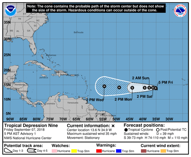
The National Hurricane Center upgraded IN92L to Tropical Depression 9 at 5pm. The cone of uncertainty indicates it is heading for the islands. (See Attached).
Of course things can change so this needs to be monitored closely and necessary preparations put in place.
Other than that it has been a nice day and looks to remains so for a few days.
A high pressure system will dominate, keeping the atmosphere relatively dry and stable. Light to gentle breeze associated with a slack pressure gradient will result in relatively warm daytime temperatures
mainly Sunday and Monday with a subsequent gradual increase to a moderate wind flow by Tuesday. Possibly starting Wednesday, rain bands associated with Tropical Depression 9 (soon to be a hurricane) could begin to affect the island.
Regards
Frank Goodwill
Sent from
Mail for Windows 10
|
Attachment:
IMG_20180907_175236.jpg
Description: IMG_20180907_175236.jpg
Attachment:
IMG_20180907_175355.jpg
Description: IMG_20180907_175355.jpg
|
|
- Things Are Livening Up!
|
- By Frank Goodwill <nevis.storm at hotmail.com>
- Date: Sun, 2 Sep 2018 19:53:11 +0000
|
Good afternoon all,
It looks like the Atlantic is waking up as we near the peak of the Hurricane season. Another Tropical Wave leaving Africa following Florence will need to be watched for development. See attached.
For the here and now, a tropical wave will generate some unsettled weather
conditions Sunday overnight into Monday. Cloudy spells with showers are likely along with possible thunderstorms. Otherwise, a high pressure system will dominate the area, keeping conditions relatively dry and stable. There will be at most,
a moderate chance
of showers expected during the rest of the week.
Today (Sunday) from a bright start cloud has slowly built up.
Keep watching,
Frank Goodwill
https://www.wunderground.com/personal-weather-station/dashboard?ID=ISAINTGE361
Attachment:
IMG_20180902_145303.jpg
Description: IMG_20180902_145303.jpg
Attachment:
IMG_20180902_150251.jpg
Description: IMG_20180902_150251.jpg
Attachment:
IMG_20180902_150258.jpg
Description: IMG_20180902_150258.jpg
|
|
- Aug Weather Data Summary
|
- By "Harry W. Hallstrom" <hwh888 at gmail.com>
- Date: Sat, 1 Sep 2018 07:15:37 -0400
|
Greetings All,
Attached weather data for month of August here on Nevis.
Attachment:
August 2018 - NOAA Weather Data.pdf
Description: Adobe PDF document
|
|
- Raining! Nice!!
|
- By Frank Goodwill <nevis.storm at hotmail.com>
- Date: Wed, 29 Aug 2018 13:56:01 +0000
|
|
Good morning all,
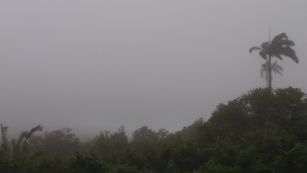
The "active" Tropical Wave passing through the area has delivered showers and periods of rain overnight and this morning. Estimated rainfall overnight to this morning in the Nevis Peak foothills is 17mm.
Looking at the Guadeloupe radar there is plenty more to come - See attached. St. Kitts and Nevis are located in the top left hand square.
I'm not complaining, as rainfall has been scarce over the last couple of months.
I have also attached a couple of photos of the weather view this morning - a damp looking "grey out".
As for the "disturbance" forecast to form off of the African coast this weekend. That is for another post.
The old weather station started playing up last night as the temperature guage readings are very high. It is either a fault or the rechargeable batteries need replacing. A bit too wet for me out there at the moment, so an investigation will have to wait. :)
Regards,
Frank Goodwill
Pond Hill, Nevis Weather Station
Outlook for Android
|
|
- Leeward Islands Rain
|
- By "Harry W. Hallstrom" <hwh888 at gmail.com>
- Date: Wed, 29 Aug 2018 07:58:59 -0400
|
Greetings All,
Looking at weather station data from around this area, BVI to St. Lucia, the Leewards seem to be getting blessed with fair amounts of rain. The Satellite images appear to confirm that.
|
|
- "Active" Tropical Wave
|
- By Frank Goodwill <nevis.storm at hotmail.com>
- Date: Mon, 27 Aug 2018 14:02:54 +0000
|
Good morning all,
Isolated scattered showers seem to be the weather forecast for Monday and Tuesday here in Nevis.
For a change we have an "Active" Tropical Wave approaching the area. This is forecast to possibly bring isolated thunderstorms, an increase in shower activity and cloudy weather on Wednesday and Thursday this week.
An increase in wind speed is anticipated from Wednesday and in response significant wave heights will become slightly elevated. Hence, a small craft advisory will likely be issued for this period.
Regards,
Frank Goodwill
Pond Hill Weather Station
https://www.wunderground.com/personal-weather-station/dashboard?ID=ISAINTGE361
|
|
- Weak Tropical Waves
|
- By Frank Goodwill <nevis.storm at hotmail.com>
- Date: Sat, 25 Aug 2018 13:26:47 +0000
|
Good morning all,
Weak Tropical Waves continue to pass us by. We managed to receive just over 1mm of rain in the foothills of Nevis Peak, during the early hours of Friday. Low mosture levels continue to inhibit significant cloudiness and showers.
We had a brief shower of light drizzle at about 5:30 pm Friday evening. It didn't produce a measurement but resulted in rainbow as the sun began to set.
Another weak Tropical will pass us by late Sunday and into Monday and it is forecast to bring some cloudiness and possible showers.
The Tropical Wave highlighted by the US National Hurricane Center that was forecast to have a low chance of development, has fizzled out and is not on their radar anymore. Due to the environmental conditions in the Atlantic that is not surprising.
The dry 'wet season' continues for us.
I have attached a some photos of the view from Friday plus a picture of the rainbow.
Regards,
Frank Goodwill
Pond Hill Weather Station
https://www.wunderground.com/personal-weather-station/dashboard?ID=ISAINTGE361
Attachment:
IMG_20180824_121622.jpg
Description: IMG_20180824_121622.jpg
Attachment:
IMG_20180824_121630.jpg
Description: IMG_20180824_121630.jpg
Attachment:
IMG_20180824_175633.jpg
Description: IMG_20180824_175633.jpg
|
|
- Still Remaing Dry
|
- By Frank Goodwill <nevis.storm at hotmail.com>
- Date: Tue, 21 Aug 2018 12:42:41 +0000
|
|
Good morning all,
The weather remains calm and dry as another weak Tropical Wave approaches. There is a possibility of isolated showers during Tuesday into Wednesday, though present conditions indicate it remaining mostly dry. The high pressure system to the north will continue
to keep weather conditions relatively dry and stable with, at most, a low chance of showers during the remainder of the week. The winds will be easterly for the next several days.
The last few days have been dry with only a light shower on Monday evening, providing a scant 0.3mm of rain up in the Nevis Peak foothills.
The last communiqué from the Nevis Water Department highlights the lack of rainfall we have been having:
16th August 2018
The Nevis Water Department would like to inform the General Public that many areas are experiencing low water pressure due to low water levels.
Please continue to conserve your water by:
1. Repairing leaking devices i.e faucets, toilets, pipes
2. Minimize the watering of lawns and employ smart irrigation techniques
3. Watering lawns at dusk
4. Monitoring daily water use such as having an open faucet whilst brushing teeth.
Saving water is a conscious effort. Remember every drop counts.
Regards,
Frank Goodwill
Pond Hill, Nevis Weather Station
Outlook for Android
|
|
- Invest 99L Fizzles Out, More to Come?
|
- By Frank Goodwill <nevis.storm at hotmail.com>
- Date: Sun, 19 Aug 2018 04:59:25 +0000
|
Good night all,
Invest 99L has fizzled out so the forecast for Nevis on Sunday and Monday.
Relatively dry and stable atmosphere is expected to linger across the area for the next few days. This is due to a high pressure ridge and the associated moderate trade wind flow. This can occasionally transport shallow pockets of low level
moisture over and around the island. These conditions could result in a moderate chance of brief passing showers,
mainly during late Sunday and into early Monday.
As we move towards the peak of the Hurricane season, the Atlantic Ocean surface temperatures (SST) are back to average as a whole. A big warm up has occurred over the last couple of weeks and further warming is possible during the next several
weeks.
A robust African wave is about to make a splashdown in the Atlantic. We will see if there is any possible development during this coming week.
Pond Hill Weather Station.
https://www.wunderground.com/personal-weather-station/dashboard?ID=ISAINTGE361
|
|
- Invest 99L
|
- By Frank Goodwill <nevis.storm at hotmail.com>
- Date: Thu, 16 Aug 2018 03:30:45 +0000
|
|
Good night all,
We have had a few rumbles of thunder and a couple of showers so far today from the Tropical Wave passing us today. Up in the foothills of Nevis Peak we managed to get 2.3mm (nearly a tenth of an inch) of rain.
The wave will continue affect the area tonight into tomorrow. From Friday a surface high pressure will dominate the area bringing stable conditions.
Another tropical wave will affect the area by Sunday and this will increase the chance of showers across the islands. This Tropical Wave has become a weather disturbance of interest - IN99L.
The US National Hurricane Center are forecasting a low chance of cyclonic formation - 10% through the next 48 hours and 20% through the next 5 days. (See attached)
So we watch to see how things progress over the next few days. Adverse wind conditions are forecast to come into play, once the wave has passed the islands into the Eastern Caribbean Sea. This will inhibit any further development.
Regards,
Frank Goodwill
Pond Hill, Nevis Weather Station
Outlook for Android
|
|
- As Dry As Chips
|
- By Frank Goodwill <nevis.storm at hotmail.com>
- Date: Wed, 15 Aug 2018 04:41:03 +0000
|
Good night all,
A weak tropical wave is due to pass through the area on Wednesday. This will increase the chance of shower activity through Wednesday into Thursday. Otherwise a high pressure system will continue to keep conditions stable and relatively dry.
The wind will be easterly and moderate for the rest of the week.
A brief shower on Sunday last, managed to provide 1mm of rain measured on the weather station. Therefore things have remained pretty dry, especially on the Windward (Atlantic) side of the island.
This dry weather is starting to impact on the public water supply, as the existing water aquifers are not being adequately replenished. On Thursday 9th August the Nevis Water Department began to ration water to certain parts of the island.
"The Nevis Water Department wishes to advise the General Public that due to the low water levels being experienced, water supply in the following areas will be interruppted;
Zion village, Hanleys Road, Hichmans, Rices, Victoria Road, BrownHill, Cherry Gardens, Prospect, Bath Village, Ramsbury, Charlestown, West Bury. This interruption will occure between 9:30 pm and 4:00 am .
This exercise will commence Today August 9, 2018. The Water Department aplogizes for any inconvenience these interruptions may cause."
Antigua Met Services are also measuring low rain fall in Antigua at the V.C.Bird Airport (see attached).
Below average sea surface temperatures in the Atlantic and wind shear, continue to surpress cyclonic activity but also reduces rainfall totals.
One positive is the Saharan Dust has gone at the moment (see attached photo views).
Regards,
Frank Goodwill
Pond Hill Weather Station
https://www.wunderground.com/personal-weather-station/dashboard?ID=ISAINTGE361
Attachment:
IMG_20180814_172117.jpg
Description: IMG_20180814_172117.jpg
Attachment:
IMG_20180814_153005.jpg
Description: IMG_20180814_153005.jpg
Attachment:
IMG_20180814_153019.jpg
Description: IMG_20180814_153019.jpg
Attachment:
IMG_20180814_153027.jpg
Description: IMG_20180814_153027.jpg
|
|
- All Quiet and Dry
|
- By Frank Goodwill <nevis.storm at hotmail.com>
- Date: Sun, 12 Aug 2018 14:07:34 +0000
|
Good morning all,
As usual up in the foothills of Nevis Peak it is a "Sunny Sunday" with a good breeze.
The mid-Atlantic weather disturbance highlighted by the US National Hurricane Center, stalled and has now fizzled out due to adverse conditions.
A passing Tropical Wave on Friday/Saturday only gave us a thunderstorm and 3.5 mm of rain on Friday. So things continue to be pretty dry around here. The haze due to Saharan Dust has mainly cleared so I can now see the sea/sky horizon.
Tropical Waves continue to leave the West African Coast and cross the Atlantic to the Caribbean. Their development continues to be curtailed by lower than average sea surface temperatures and wind shear. With a little help from dry air from
the Saharan Air Layer and it's associated dust.
For the week ahead stable weather conditions are expectheted to prevail. Two tropical waves are expected to generate cloudy periods and at least a moderate chance of showers on Tuesday and the other towards
the end of the week. It would be nice to have some rain.
Attached: Sunny Sunday in Nevis.
Regards,
Frank Goodwill
Pond Hill Weather Station
https://www.wunderground.com/personal-weather-station/dashboard?ID=ISAINTGE361
Attachment:
IMG_20180812_090855_283.jpg
Description: IMG_20180812_090855_283.jpg
|
|
- All Quiet and Dry
|
- By Frank Goodwill <nevis.storm at hotmail.com>
- Date: Sun, 12 Aug 2018 13:47:01 +0000
|
Good morning all,
As usual up in the foothills of Nevis Peak it is a "Sunny Sunday" with a good breeze.
The mid-Atlantic weather disturbance highlighted by the US National Hurricane Center, stalled and has now fizzled out due to adverse conditions.
A passing Tropical Wave on Friday/Saturday only gave us a thunderstorm and 3.5 mm of rain on Friday. So things continue to be pretty dry around here. The haze due to Saharan Dust has mainly cleared so I can now see the sea/sky horizon.
Tropical Waves continue to leave the West African Coast and cross the Atlantic to the Caribbean. Their development continues to be curtailed by lower than average sea surface temperatures and wind shear. With a little help from dry air from
the Saharan Air Layer and it's associated dust.
For the week ahead stable weather conditions are expectheted to prevail. Two tropical waves are expected to generate cloudy periods and at least a moderate chance of showers on Tuesday and the other towards
the end of the week. It would be nice to have some rain.
Attached: Sunny Sunday in Nevis.
Regards,
Frank Goodwill
Pond Hill Weather Station
https://www.wunderground.com/personal-weather-station/dashboard?ID=ISAINTGE361
Attachment:
IMG_20180812_090855_283.jpg
Description: IMG_20180812_090855_283.jpg
|
|
- Things Waking Up For Next Week?
|
- By Frank Goodwill <nevis.storm at hotmail.com>
- Date: Fri, 10 Aug 2018 12:35:25 +0000
|
|
Good morning all,
Things might be waking up for next week!
From the US National Hurricane Center.
CZC MIATWOAT ALL
TTAA00 KNHC DDHHMM
Tropical Weather Outlook
NWS National Hurricane Center Miami FL
800 AM EDT Fri Aug 10 2018
For the North Atlantic...Caribbean Sea and the Gulf of Mexico:
1. An area of disturbed weather is located about midway between Africa and the Lesser Antilles. Environmental conditions are expected to become conducive for some gradual development while the system moves
slowly west over the next few days. By the middle of next week, stronger upper-level winds could limit the chance for further
development.
* Formation chance through 48 hours...low...10 percent.
* Formation chance through 5 days...low...20 percent.
Forecaster Zelinsky
See attached 5 day forecast.
Pond Hill, Nevis Weather Station
Outlook for Android
|
|
- Saharan Dust Eased Off
|
- By Frank Goodwill <nevis.storm at hotmail.com>
- Date: Thu, 9 Aug 2018 03:10:32 +0000
|
|
Good night all,
Had a light shower very early Wednesday morning, yielding 0.3 mm of rain. Today (Wednesday) the Saharan Air Layer and its associated dust has eased off somewhat. A comparison of Tuesday's and Wednesday's noon time weather views shows the subtle difference.
A little more blue colour to the sky.
My car was covered with a little more dust that was washed out of the air by the shower mentioned.
Regards,
Frank Goodwill
Pond Hill, Nevis Weather Station
Outlook for Android
|
|
- Sunny and Hazy.... still
|
- By Frank Goodwill <nevis.storm at hotmail.com>
- Date: Wed, 8 Aug 2018 06:03:03 +0000
|
Good night all,
Another plume of Saharan Dust (dry air) has reached us which is stifling any shower activity. The dry air continues to keep any associated Tropical Wave activity to a minimum in this part of the Caribbean. The
last Tropical wave that passed by on Sunday produced 1.5 mm of rain in our area – not a lot.
The weather will continue to remain dry and stable due to the presence of a ridge of high pressure and the Saharan Dust. As a result skies will remain hazy, fair to partly cloudy, with low chances for showers.
Another Tropical Wave passing through the area will increase the chances for cloudiness and showers to moderate on Friday and Saturday.
- Attached a couple of noon time weather pictures from Tuesday.
- After the short sharp showers on Sunday I have included a picture of my red car hood showing some Saharan Dust that had been “washed” out of the air by the
rain.
- Final picture is of Potwork’s Dam Reservoir in Antigua (credit: Antigua Met Services). Designed to hold 1 billion gallons of water and is seasonal, it demonstrates
how dry the wet season has been so far. To quote Antigua Met Services “Dry as Chips”!
Another named Storm has come into play – “Debby”. Another one to tick off the list but will soon fade away as it moves across the colder waters of the North Atlantic. No land fall/impact.
The only storm to provide some excitement so far this Hurricane Season has been “Beryl” that gave us about 30mm of rain and took out the grid supply in my area for 10 hours due to a lightning strike. You don’t
have to have a hurricane on your doorstep to have problems!
The latest forecast (2nd August 2018) from the Colorado State University.
FORECAST OF ATLANTIC SEASONAL HURRICANE ACTIVITY AND LANDFALL STRIKE PROBABILITY FOR 2018
We continue to forecast a below-average Atlantic hurricane season. The tropical Atlantic remains cooler than normal, and there is a relatively high potential that a weak El Niño develops in the next several months. The probability for major
hurricanes making landfall along the United States coastline and in the Caribbean is below normal due to the forecast for a below-average season. As is the case with all hurricane seasons, coastal residents are reminded that it only takes one hurricane making
landfall to make it an active season for them.
They should prepare the same for every season, regardless of how much activity is predicted.
https://tropical.colostate.edu/media/sites/111/2018/08/2018-08.pdf
Hurricanes and Their Impact
We always focus on the physical damage of hurricanes but there is always the mental health side after the event. If your interested please find a link to the UK Guardian Newspaper about Puerto Rico after last year’s
hurricanes.
https://www.theguardian.com/world/2018/aug/07/despair-and-anxiety-puerto-ricos-living-emergency-as-a-mental-health-crisis-unfolds
Sorry if this is a bit of a long one, but I thought the content might be interesting.
Regards,
Frank Goodwill
Pond hill Weather Station:
https://www.wunderground.com/personal-weather-station/dashboard?ID=ISAINTGE361
Sent from
Mail for Windows 10
|
Attachment:
20180807 noon1.jpg
Description: 20180807 noon1.jpg
Attachment:
20180807 noon2.jpg
Description: 20180807 noon2.jpg
Attachment:
saharan dust hood 20180806.jpg
Description: saharan dust hood 20180806.jpg
Attachment:
20180808 potworks dam.jpg
Description: 20180808 potworks dam.jpg
|
|
- July NOAA Weather Date Report
|
- By "Harry W. Hallstrom" <hwh888 at gmail.com>
- Date: Thu, 2 Aug 2018 07:28:37 -0400
|
Greetings All,
Attached July's weather data.
Interesting data this year, I looked back at July 2017 data and this year were almost half as many days above 90. Last year most were 92 F - 96 F. The big High pressure sitting over the mid Atlantic keep funneling cooling air off the Atlantic our way.
Attachment:
July 2018 - NOAA Weather Data.pdf
Description: Adobe PDF document
|
|
- All Quiet - What Next?
|
- By Frank Goodwill <nevis.storm at hotmail.com>
- Date: Wed, 1 Aug 2018 12:24:20 +0000
|
Good morning all,
It seems like it is sunny days with some cloud with the odd overnight shower at the moment.
The Colorado State University are due to publish their final hurricane season forecast tomorrow, 2nd August. It will be interesting to see how they see the season progressing. The forecast they produced early on started out as an 'Active' season,
then it became a 'Normal to near normal' season. These forecasts are interesting but are only advisory.
A quiet season so far due mainly to the Saharan Dust, lower than average sea surface temperatures in the Tropical Atlantic and the presence of wind shear The Tropical Wave conveyor belt has been rolling along from West Africa to the Caribbean,
but conditions have not been favourable for cyclonic development so far. These conditions have also resulted in a Wet Season with lower rainfall than normal, so far, in the Leeward Islands.
The following link shows another day in paradise. Yesterday's morning view out to sea from Charlestown.
As the camera pans to the right haze obscures the view of St. Kitts. This due to the Saharan Dust which has been with us at varying intensity for a while now.
https://youtu.be/5eCJkPL3Mbg
Regards,
Frank Goodwill
Pond Hill Weather Station
https://www.wunderground.com/personal-weather-station/dashboard?ID=ISAINTGE361
|
|
- Cloud and Sunshine
|
- By Frank Goodwill <nevis.storm at hotmail.com>
- Date: Tue, 31 Jul 2018 03:09:17 +0000
|
Good night all,
The Tropical Wave that passed over us Sunday into Monday gave us some fleeting showers. The wind picked up from about midday Monday, giving some strong gusts. Overall it has been mainly sunny with some cloud and a little hazy.
The Saharan Dust is still around but is not as intense as in recent weeks.
Attached is a couple of sunset photos from today on Nevis.
Stable weather conditions are forecast for Tuesday and Wednesday, with partly cloudy skies with slight possibility of moderate showers.
Thursday afternoon into Friday will be unsettled as anothet Tropical Wave moves into the area. This will probably increase the chances of showers.
So far the Hurricane season has remained quiet and this is not unusual. Most years, the first two months of the season (June and July) are typically benign. June averages only one named storm every other year, and July has averaged one named
storm per year since 1950. Then comes August and it's almost as if a switch is flipped.
August sees more than three times the number of named storms as July, and almost double the number of June and July storms combined. As August progresses, the number of named storms steadily increases on average.
So August is the time to start to keep an eye on the forecasts.
Regards,
Frank Goodwill
Pond Hill Weather Station.
https://www.wunderground.com/personal-weather-station/dashboard?ID=ISAINTGE361
Attachment:
gqBxp6apnJSnnZu2qJ1lqZewnZanmpY=.jpg
Description: gqBxp6apnJSnnZu2qJ1lqZewnZanmpY=.jpg
Attachment:
eaB1rJytnpS4qZqnqJ1lqZewnZWmmJo=.jpg
Description: eaB1rJytnpS4qZqnqJ1lqZewnZWmmJo=.jpg
|
|
- Hazy Sunshine and Cloud.
|
- By Frank Goodwill <nevis.storm at hotmail.com>
- Date: Thu, 26 Jul 2018 22:07:31 +0000
|
|
Good afternoon all,
We didn't get much rain from the passing Tropical Wave on Tuesday and Wednesday. There were a couple of scattered showers around the island giving a few millimetres locally. The Saharan Air Layer continues to give hazy conditions with little shower activity.
Today has been cloudy with some intervals of hazy sunshine.
High pressure remains dominant with an atmosphere low in moisture, this will result in a low chance of showers for the next two days. On Sunday, a weak tropical wave entering the region will bring some moisture and instability. This could increase the chance
of showers to a moderate level or around 60 percent.
Thereafter, a dry mass of air along with an increase in Saharan dust will keep the chances of showers low with mostly hazy conditions. Easterly and moderate to fresh winds will continue to prevail.
A further two Tropical Waves are presently in the Atlantic heading towards the Caribbean.
Attached is a couple of photos from today's late afternoon weather.
Pond Hill, Nevis Weather Station
Outlook for Android
|
|
- Brightened Up
|
- By Frank Goodwill <nevis.storm at hotmail.com>
- Date: Mon, 23 Jul 2018 15:17:16 +0000
|
Good morning all,
Things have brightened up today (Monday) as the Saharan Dust is giving us a break. We had a few showers on Sunday but nothing to get excited about.
There should be an increased chance of shower activity as Tuesday arrives with the presence of a Tropical Wave.
Two more Tropical Waves are are in the Atlantic approaching the Caribbean. It looks as if we will see out July with little chance of Tropical Cyclone activity.
Attached is the view from the Nevis Peak foothills with a clear sea/sky horizon, but with the occasional dark cloud passing from the east threatening a shower.
Regards,
Frank Goodwill
Pond Hill Weather Station
https://www.wunderground.com/personal-weather-station/dashboard?ID=ISAINTGE361
Attachment:
IMG_20180723_102901.jpg
Description: IMG_20180723_102901.jpg
Attachment:
IMG_20180723_102916.jpg
Description: IMG_20180723_102916.jpg
Attachment:
IMG_20180723_110211.jpg
Description: IMG_20180723_110211.jpg
|
|
- Dry and Dusty
|
- By Frank Goodwill <nevis.storm at hotmail.com>
- Date: Sun, 22 Jul 2018 01:17:25 +0000
|
Good evening all,
A weak low level trough could generate some scattered showers
during early Sunday. Partly cloudy skies along with an abundance of upper level clouds will prevail over the next few days. There will be a moderate chance of showers. On Tuesday, a tropical wave will also move across
the area. Moisture and instability ahead of this wave could see some unsettled weather overnight Monday into Tuesday. In the wake of this wave, hazy conditions will once again become evident as concentrations of Saharan Dust are expected to once again increase.
Otherwise, the high pressure system will dominate the area keeping weather conditions relatively dry and stable.
There is another Tropical Wave in the Atlantic approaching the Caribbean. Present conditions of dry air and wind shear will continue to inhibit Cyclone formation.
Anyway, weather aside it's Mango time on Nevis and I have been making the most of it.
See attached photos
Regards,
Frank Goodwill
https://www.wunderground.com/personal-weather-station/dashboard?ID=ISAINTGE361
Attachment:
IMG_20180721_104712.jpg
Description: IMG_20180721_104712.jpg
Attachment:
IMG_20180721_104820.jpg
Description: IMG_20180721_104820.jpg
Attachment:
IMG_20180721_105716.jpg
Description: IMG_20180721_105716.jpg
Attachment:
IMG_20180721_112138.jpg
Description: IMG_20180721_112138.jpg
|
|
- Onward to the weekend.
|
- By Frank Goodwill <nevis.storm at hotmail.com>
- Date: Fri, 20 Jul 2018 00:44:10 +0000
|
Good afternoon all,
The Tropical Wave that passed us by today (Thursday) gave us a couple of light showers giving less than 2mm of rain in the Nevis Peak foothills.
The next pulse of the Saharan Air Layer (SAL) and accociated dust is with us. Therefore we are back to hazy conditions. The strong breezes are due to ease of as the weekend approaches.
The next Tropical Wave is making its way across the Atlantic, and should be with us on Sunday. This again will increase the chance of shower activity and cloudiness.
With the SAL supplying dry air over the region, it will reduce the chances of Tropical Cyclone activity.
As we press on towards the end of July, we edge closer to the busy period of late August and September of the Hurricane Season. So we wait to see how things develop.
Attached are a couple of photos of the cloudy day on Nevis today.
Regards,
Frank Goodwill
https://www.wunderground.com/personal-weather-station/dashboard?ID=ISAINTGE361
Attachment:
gqBxp6apnJSnnZu2qJ1lqZenlpWtm5k=.jpg
Description: gqBxp6apnJSnnZu2qJ1lqZenlpWtm5k=.jpg
Attachment:
eaB1rJytnpS4qZqnqJ1lqZenmJSsnZw=.jpg
Description: eaB1rJytnpS4qZqnqJ1lqZenmJSsnZw=.jpg
|
|
- Showery Sunday
|
- By Frank Goodwill <nevis.storm at hotmail.com>
- Date: Sun, 15 Jul 2018 22:11:36 +0000
|
|
A pleasant Sunday to all,
A tropical wave is generating weak unstable conditions today and into Monday. This has resulted in cloudy spells and some scattered showers. Following this wave hazy conditions will resume due to Saharan dust. Later on Thursday, another tropical wave will move
across the area and will result in an increase in showery weather. Otherwise, moderate to fresh breezes associated with the Atlantic high pressure system will transport pockets of moisture across the area possibly triggering occasional cloudy spells with,
at most, a moderate chance of showers while keeping sea conditions slightly above normal during the week. However, only a caution for small craft operators will be in effect.
Attached: Cloudy afternoon.
Radar picture of scattered showers in the area.
Regards,
Frank Goodwill
Pond Hill, Nevis Weather Station
Outlook for Android
|
|
- Beryl - Nevis Monday 11am
|
- By Frank Goodwill <nevis.storm at hotmail.com>
- Date: Mon, 9 Jul 2018 15:27:14 +0000
|
|
Good morning all,
The remnent of Beryl has passed us by with the rain stopping at about 9am.
The sky is cloudy with a breeze blowing.
NEVLEC are busy putting the areas where the electricity was knocked out back on. Jones' Estate area is back on.
I am sure the plants enjoyed the soaking and that Nevis will look greener after the long dry spell.
Attached:
Picture of the Guadeloupe rain radar at 9:45am. Sky's looking a lot clearer.
A couple of pictures of the weather view on Nevis at about 11am
Regards,
Frank Goodwill
Pond Hill, Nevis Weather Station
Outlook for Android
|
|
- Beryl - Nevis Monday 6am
|
- By Frank Goodwill <nevis.storm at hotmail.com>
- Date: Mon, 9 Jul 2018 14:29:38 +0000
|
|
Good morning from a very damp Nevis.
We have had about 3 hours of rain this morning of various intensity. Looking at the Guadeloupe rain radar we are due for some more. We seem to be in a rain corridor at the moment.
Attached is the rain radar picture at 6am with St Kitts and Nevis in the top left hand corner. The weather is moving in a general West-northwest direction.
Unlike earlier no thunder and lightning and the wind has calmed down.
I have been informed that power went off in the Jones' Estate area at 2:15am.
Power still of in my location.
Also attached is a picture of a wet and misty start to the day.
Pond Hill, Nevis Weather Station
Outlook for Android
|
|
- Beryl - Nevis Monday 3:30am
|
- By Frank Goodwill <nevis.storm at hotmail.com>
- Date: Mon, 9 Jul 2018 08:00:39 +0000
|
|
Good morning all,
After a pretty violent 30 minutes things have calmed down. Now getting some light showers with cloud lightning and occasional rumbles of thunder.
NEVLEC electricity is still off but just in my locality. Looks like a minor feeder suffered a lightning strike between the Pond Hill community centre up to the Dunbar Mill then down towards the Hermitage Hotel. This feeder is very exposed as it runs along a
ridge on the Zetlands Road (for those who know the area).
Always a problem living up in the Nevis Peak foothills.
The weather station is down as it is not on backup.
Latest rain radar picture 3:30 am shows St Kitts and Nevis in an oasis of calm before the next area of rain arrives.
(St Kitts and Nevis in the top left hand corner).
Regards,
Frank Goodwill
Pond Hill, Nevis Weather Station
Outlook for Android
|
|
- Beryl - Nevis Monday 2:30 am
|
- By Frank Goodwill <nevis.storm at hotmail.com>
- Date: Mon, 9 Jul 2018 06:52:38 +0000
|
|
Early good morning,
The first real impact of Beryl has arrived with a heavy downpour, gusty winds and some thunder and lightning. Large clap of thunder with lining has just taken our NEVLEC power grid down in the area (Gingerland Feeder).
Latest rain radar attached.
St Kitts and Nevis in the top left hand corner. Present rain etc shown in bright blue.
Regards,
Frank Goodwill
|
|
- Beryl - Nevis into Monday
|
- By Frank Goodwill <nevis.storm at hotmail.com>
- Date: Mon, 9 Jul 2018 04:34:19 +0000
|
|
Good night all,
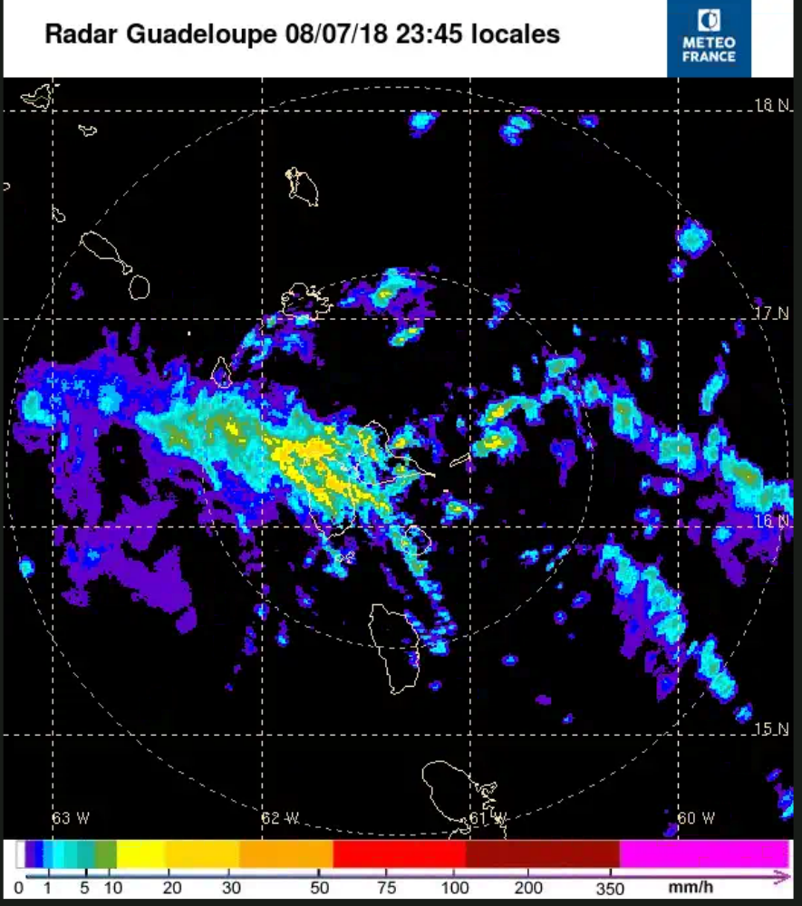
We haven't had any real impact from the leftovers of Beryl as yet. It looks as if Guadeloupe has experienced pouring rain with winds of 28 mph gusting to 50 mph.
All being well the heavy rain should track just to the south of Nevis during the early hours of Monday. We will probably experience some periods of showers with gusting winds looking at the Guadeloupe rain radar.
Attached photo of rain radar. Guadeloupe in the centre (yellow shows heavy rain). St Kitts and Nevis are in the top left hand corner.
Being a 36 sq miles island rain showers can be a bit of a hit or miss affair.
Up in the Nevis Peak foothills we are experiencing some wind gusts and a couple of light showers. To be honest the wind doesn't seem that much different from the trade winds we have experienced over the past few days.
Regards,
Frank Goodwill
Pond Hill, Nevis Weather Station
Outlook for Android
|
|
- Beryl continues to weaken. Nevis Sunday 8pm
|
- By Frank Goodwill <nevis.storm at hotmail.com>
- Date: Mon, 9 Jul 2018 00:28:39 +0000
|
|
Good night all,
The strength of Beryl continues to decline.
Beryl has dissipated and is now an open tropical wave. The remnants of Beryl will bring some rain and gusty winds to portions of the Lesser Antilles tonight.
The first light rain shower has arrived in Nevis. The Guadeloupe rain radar shows an area of rain in the vicinity of Guadeloupe and Dominica, moving in a west-northwest direction.
Attached photos:
Nevisian sunset today.
View out towards the Caribbean Sea.
Guadeloupe rain radar 8pm
Regards,
Frank Goodwill
Pond Hill, Nevis Weather Station
Outlook for Android
|
|
- Nevis Update
|
- By "Harry W. Hallstrom" <hwh888 at gmail.com>
- Date: Sun, 8 Jul 2018 17:22:13 -0400
|
Greetings All,
Much to credit of NHC good data reads Beryl has been downgraded to a tropical wave. Satellite images show wind sheer has ripped apart the storm. Still can expect rain and some gusty winds.
At present its sunny and pleasant with a 15 kt breeze.
|
|
- TS Beryl - Nevis 2pm Sunday
|
- By Frank Goodwill <nevis.storm at hotmail.com>
- Date: Sun, 8 Jul 2018 18:45:47 +0000
|
|
Good afternoon all,
Not a very "Sunny Sunday" in Nevis at the moment. Cloud is starting to build up and it is a little hazy. It has been hazy for some time now mainly due to the Saharan Air Layer (SAL) and the associated dust.
(See attached picture).
TS Beryl continues its approach though it appears to be weakening after its short period of being a hurricane.
Looking at the Guadeloupe radar, shower bands are approaching the islands.
(See attached - St Kitts and Nevis are in the top left corner of the picture).
This will probably result in some gusty tropical downpours.
Regards,
Frank Goodwill
Pond Hill, Nevis Weather Station
Outlook for Android
|
|
- Sunday 5am Data
|
- By "Harry W. Hallstrom" <hwh888 at gmail.com>
- Date: Sun, 8 Jul 2018 08:05:38 -0400
|
Greetings All,
Just had a look at NHC data 5am report. The storm is approx 500 mi SE of NEV/SKB moving in a Westerly/North direction at 290 deg (270 deg is due West) Path is projected to pass approx 90 miles directly South of NEV/SKB at 5am Monday.
Winds.......10% of 35-50 MPH Gusts in our area.
Sustained speeds approx 22 mph this time Monday 5-8 am. Decreasing rather quickly as storm moves away.
|
|
- Hurricane Beryl Analysis #2
|
- By "Harry W. Hallstrom" <hwh888 at gmail.com>
- Date: Sat, 7 Jul 2018 07:38:38 -0400
|
Latest NHC data Saturday 5 am............
Path hasn't changed much. 36 hrs (Sunday 5 pm) puts Beryl 400 mi SE of NEV / SKB
48 hrs (Monday 5 am) puts Beryl 180 mi S of NEV / SKB Path projection, direction change from 270 deg to 285 deg
Winds have been lowered a bit to 21 mph sustained with gusts to 33 mph (Monday 8 am)
|
|
- Hurricane Beryl Analysis
|
- By "Harry W. Hallstrom" <hwh888 at gmail.com>
- Date: Fri, 6 Jul 2018 17:34:00 -0400
|
Greetings All,
Been looking at latest data from NHC and this is what I conclude........
36 hrs from now (Sunday 5pm) storm will be 378 miles SE of NEV Closest point as she passes to the South will be in range of 200 mi South.
Projected winds Monday 8am 25 MPH sustained with gusts to 40 MPH.
Based on NHC and path remaining 270 deg westward this is what NEV & SKB can expect.
|
|
- NHC Key Message TS Beryl
|
- By Frank Goodwill <nevis.storm at hotmail.com>
- Date: Fri, 6 Jul 2018 03:57:36 +0000
|
Good night all,
Key message from US National Hurricane Center attached.
Regards,
Frank Goodwill
https://www.wunderground.com/personal-weather-station/dashboard?ID=ISAINTGE361
Attachment:
023407_key_messages_sm.png
Description: 023407_key_messages_sm.png
|
|
- Nevis NOAA Weather Date for June 2018
|
- By "Harry W. Hallstrom" <hwh888 at gmail.com>
- Date: Thu, 5 Jul 2018 19:54:56 -0400
|
Greetings All,
Attached weather station data for month of June.
Attachment:
June 2018 - NOAA Weather Data.pdf
Description: Adobe PDF document
|
|
- Disturbance in the Atlantic. Outlook NHC update
|
- By Frank Goodwill <nevis.storm at hotmail.com>
- Date: Wed, 4 Jul 2018 21:17:53 +0000
|
|
Good afternoon all,
US National Hurricane Center has cranked up the forecast for the disturbance crossing the Atlantic (see 2)
A quick development as they have issued a special 5pm weather outlook
ZCZC MIATWOAT ALL
TTAA00 KNHC DDHHMM
Special Tropical Weather Outlook
NWS National Hurricane Center Miami FL
455 PM EDT Wed Jul 4 2018
For the North Atlantic...Caribbean Sea and the Gulf of Mexico:
Special tropical weather outlook issued to update the discussion of the low pressure area west-southwest of the Cabo Verde Islands.
1. Disorganized showers and thunderstorms located within a few hundred miles to the south of Bermuda are associated with a trough of lowpressure. Environmental conditions appear conducive for some
development of this system, and a tropical depression could form before the end of the week while the system moves west-northwestward and then northward between Bermuda and the east coast of the United
States. The system is then forecast to interact with a frontal system on Sunday, which would limit any additional development.
* Formation chance through 48 hours...medium...40 percent.
* Formation chance through 5 days...medium...60 percent.
2. Satellite imagery indicates that shower activity associated with asmall area of low pressure and a tropical wave located several
hundred miles west-southwest of the Cabo Verde Islands has becomebetter organized during the past few hours. Some additional
development of this system is possible, and a tropical depression could form during the next day or two while it moves westward to
west-northwestward at 15 to 20 mph over the tropical Atlantic Ocean. By the weekend, upper-level winds are expected to become less conducive for development when the system approaches the Lesser Antilles.
* Formation chance through 48 hours...medium...50 percent.
* Formation chance through 5 days...medium...50 percent.
Regards,
Frank Goodwill
Pond Hill, Nevis Weather Station
Outlook for Android
|
|
- Into July and off we go.
|
- By Frank Goodwill <nevis.storm at hotmail.com>
- Date: Wed, 4 Jul 2018 05:46:26 +0000
|
Good morning all.
A little reminder that we are in July the second month of the hurricane season with this 5 day forecast.
On average there is usually one named storm in July. Hopefully (2) will fizzle out as it moves into unfavourable conditions. But always worth keeping an eye on.
ZCZC MIATWOAT ALL
TTAA00 KNHC DDHHMM

Tropical Weather Outlook
NWS National Hurricane Center Miami FL
200 AM EDT Wed Jul 4 2018

For the North Atlantic...Caribbean Sea and the Gulf of Mexico:

1. An area of cloudiness and showers remains a few hundred miles
southeast of Bermuda. Although this disturbance is currently
disorganized, environmental conditions could become more conducive
for a low pressure system to form by late this week in the area
southwest of Bermuda.  The system is then forecast to move generally
northward over the weekend and begin interacting with a frontal
system on Sunday, which would limit any additional development.
* Formation chance through 48 hours...low...30 percent.
* Formation chance through 5 days...medium...50 percent.

2. A concentrated area of showers and thunderstorms associated with
tropical wave and a small area of low pressure is located several
hundred miles southwest of the Cabo Verde Islands. Although
satellite images show some signs of organization, the disturbance
is moving west-northwestward toward an area unfavorable for tropical
cyclone formation.
* Formation chance through 48 hours...low...20 percent.
* Formation chance through 5 days...low...20 percent.

Forecaster Avila
Regards,
Frank Goodwill
https://www.wunderground.com/personal-weather-station/dashboard?ID=ISAINTGE361
Attachment:
two_atl_5d0.png
Description: two_atl_5d0.png
|
|
- Quiet June
|
- By Frank Goodwill <nevis.storm at hotmail.com>
- Date: Tue, 26 Jun 2018 17:00:55 +0000
|
Good day all,
The weather in the first month of the hurricane season has been quiet.
For the final week in June we have a good dose of Saharan Dust over the island, bringing dry air. The sea surface temperatures in the Tropical Atlantic remain below average for this time of year. The tropical waves that have passed over us have
struggled to give us any meaningful amounts of rainfall.
The number of tropical waves coming of off the West African coast has eased this week (see attached) and there will be plenty of Saharan Dust about (shown in red on the attached).
Hazy views from Nevis due to the dust are also attached.
Regards,
Frank Goodwill
Attachment:
splitE_crop_325x325.jpg
Description: splitE_crop_325x325.jpg
Attachment:
USA.gif
Description: USA.gif
Attachment:
1530031483047.jpg
Description: 1530031483047.jpg
Attachment:
IMG_20180626_124345.jpg
Description: IMG_20180626_124345.jpg
|
|
- Brightened Up
|
- By Frank Goodwill <nevis.storm at hotmail.com>
- Date: Sat, 23 Jun 2018 18:35:04 +0000
|
Good day all,
Hot and humid Thursday turned into a cooler and wet Friday which has become a hot hazy Saturday.
Had about half an inch (12mm) of rain on Friday.
It is still considered a dry start to the wet season. See the information/article published by Antigua Met Services:
https://anumetservice.wordpress.com/2018/06/22/no-end-in-sight-for-drought-hit-antigua/
Also the Nevis Water Department issued a reminder about water conservation yesterday (Friday):
"The Nevis Water Department implores the General public to exercise water conservation practices in and around the home and work place."
https://www.facebook.com/notes/nevis-water-department/water-conservation-tips/449238618836142/
Regards,
Frank Goodwill
Pond Hill, Nevis.
https://www.wunderground.com/personal-weather-station/dashboard?ID=ISAINTGE361
Attachment:
1529777448618.jpg
Description: 1529777448618.jpg
|
|
- Tropical Waves and SAL
|
- By Frank Goodwill <nevis.storm at hotmail.com>
- Date: Tue, 19 Jun 2018 17:58:12 +0000
|
|
Good day all,
Dry and dusty Saharan Air Level is still an issue and not unusual for this time of year.
Antigua Met Services posted the following:
Saharan Dust Air Quality Bulletin
Antigua and Barbuda Meteorological Services 10:30 AM Tuesday 19 June 2018
Air Quality Index (AQI) Based on Particulate Matter 2.5 (PM2.5) and 10 (PM10)
Concentration Synopsis:
A new surge in Saharan Dust continues to stream across the area. It will continue to do so through Sunday June 24. Air quality will remain at moderate levels for the period, but at the lower end of the scale. Visibility will be slightly reduced.
Alert Level: II Location: Antigua and Barbuda
AQI: 50 to 65
AQI category: Moderate
Timing: Until Sunday
Sensitive groups: People with respiratory or heart disease, the elderly and children are the groups most at risk.
Health implications: Air quality is acceptable; however, for some pollutants there may be a moderate health concern for a very small number of people who are unusually sensitive to air pollution.
Caution: Unusually sensitive people such as active children and adults, and people with respiratory disease, such as asthma, should limit prolonged or heavy exertion.
Keep monitoring. Dale Destin
Sea surface temperatures are below average for this time of year in the Tropical Atlantic. With the dry air this helps to reduce the formation of any tropical disturbance in the Atlantic.
The old tropical wave conveyor belt from West Africa to the Americas is working well (see attached). Conditions at present are not favourable regarding tropical storm development but it does make for cloudy days.
Overcast, dry and humid best describes the weather on Nevis today.
Keep watching as we move further into the hurricane season.
Frank Goodwill
Pond Hill, Nevis Weather Station
Outlook for Android
|
|
- April NOAA Weather DAte
|
- By "Harry W. Hallstrom" <hwh888 at gmail.com>
- Date: Sun, 6 May 2018 10:40:10 -0400
|
Attached Nevis weather station data for April.
Attachment:
April 2018 - NOAA Weather Data.pdf
Description: Adobe PDF document
|
|
- Wet afternoon
|
- By Frank Goodwill <nevis.storm at hotmail.com>
- Date: Tue, 17 Apr 2018 02:30:06 +0000
|
|
Good night all,
We have had to odd shower overnight recently, but this afternoon the showers/drizzle have given us some wet stuff. Measured about 10.2mm of rain today and the temperature dropped to about 22C, so a little chilly in the Nevis Peak foothills.
The weather had been more unsettled further south.
Nice to have this little break in the 'dry season'.
Regards,
Frank Goodwill
Pond Hill, Nevis Weather Station
Weather Cams.
Outlook for Android
|
|
- Another Year......
|
- By Frank Goodwill <nevis.storm at hotmail.com>
- Date: Mon, 9 Apr 2018 08:50:44 +0000
|
|
Good morning everyone,
In Nevis it is still pretty dry which is no surprise as it is the "Dry Season". The cruise season is at an end and the "Snow Birds" do their usual migration north.
The forecasts for the 2018 hurricane season have started to appear and indicate storm activity to be above average.
I have attached the storm names for this year and also some good words from Dr Rick Knabb as a thought for the season.
Regards,
Frank Goodwill
Pond Hill, Nevis.
Weather Station
Weather Cams
Outlook for Android
!$ at !OMImageSpan! at $!1!$ at !OMImageSpan! at $!
!$ at !OMImageSpan! at $!0!$ at !OMImageSpan! at $!


|
|
- Nevis March Weather NOAA Report
|
- By "Harry W. Hallstrom" <hwh888 at gmail.com>
- Date: Sun, 1 Apr 2018 09:14:09 -0400
|
Greetings All,
Attached data for March.
As recorded data shows, very little in way of rain for the month.
Cisterns are running low and from look of satellite images & patterns it will continue into April.
Attachment:
Mar 2018 - NOAA Weather Data.pdf
Description: Adobe PDF document
|
|

