
|
|
Caribbean Hurricane Network- Updates from the Islands - |
|
|
Archive of weather discussions and eye witness reports from the Caribbean Islands in the 2004 Atlantic Hurricane Season. Postings are in reverse chronological order (so it might be easier to start reading at the bottom of this page and work your way up to follow the timeline). For current events look here.
And what a season this was..., esp. for the Bahamas, Cayman and Grenada... Storm names are picked from a list that is repeated evey 6 years. When a storm has been particularly brutal, its name is usually retired, so that we never have another one like that again. This year 4 storm names were retired! Charley, Frances, Ivan and Jeanne will be replaced with Colin, Fiona, Igor and Julia. More info about hurricane names on the NHC-website.
2004 Season: | Alex | Bonnie | Charley | Danielle | Earl | Frances | Gaston | Hermine | Ivan | Jeanne | Karl | Lisa | Matthew | Nicole | Otto
The heart of the Caribbean Hurricane Network are the personal reports send in by the special hurricane correspondents on the islands. Find out what happened on your favority island during the 2004 Hurricane Season by following the links below. | |
|
- Vieques (PR) (May 16 20:15) - Culebra (PR) (May 16 6:33) - Tortola (May 9 13:19) - Trinidad & Tobago (May 8 18:57) - Saba & Statia (May 5 11:58) - Nevis (May 1 7:55) - Bonaire (Apr 29 10:04) - St.Maarten/St.Martin (Apr 26 8:26) - Martinique (Apr 24 19:19) - Puerto Rico (Apr 23 0:50) - St.Thomas (Apr 22 19:01) - Antigua (Apr 13 1:00) - Barbados (Apr 5 13:25) - Dominican Republic (Mar 23 18:39) - Grenada (Jan 27 1:15) - St.Lucia (Jan 13 23:31) - Anguilla (Jan 5 15:24) - Dominica (Nov 22 14:18) |
- Cayman Islands (Nov 18 15:27) - St.Kitts (Nov 11 20:34) - Montserrat (Nov 9 20:55) - Mexico (incl. Cozumel & Cancun) (Oct 16 11:22) - Jamaica (Oct 9 1:00) - Bahamas (Oct 9 1:00) - Haiti (Sep 26 12:59) - Bermuda (Sep 23 13:08) - Turks & Caicos (Sep 18 14:50) - St.John (Sep 18 5:20) - St.Vincent & Grenadines (Sep 18 2:08) - St.Croix (Sep 17 1:00) - Aruba (Sep 16 11:40) - Cuba (Sep 14 11:38) - Guadeloupe (Sep 14 11:18) - Florida Keys (Sep 13 17:59) - Belize (Sep 11 1:00) - Curaçao (Sep 10 21:23) - Margarita Is., Venezuela (Sep 8 16:19) |
| - - - Otto - - - |
Although sea surface temperatures are plenty warm, this storm is not expected to become a hurricane due to some wind shear and the relative close proximity to land. Although the advisories seem to be most worried about the storm surge, which is understandable since it is moving west towards Louisiana, I think that the main problem will be the rainfall. Bertha is moving at just 3 mph, and we all know how much rain that locally can bring... You can use the tools above to check how close the storm will get to you and at what time. I have listed coordinates of Gulf cities to make it easier for you. Stay safe everybody! -Gert
November 30, 8:45PM EST - Otto
It's been quite a season, and here is another surprise... On the last official day of the hurricane season we haven another storm! Luckily this one is safely out at sea, not threatening any (is)land. Just one for the books.
| - - - Nicole - - - |
Sat, 20 Nov 2004 09:37:53 -0400 - closing of season
October 10, 5:45PM EDT - Nicole
And another one..., subtropical storm Nicole, located about 100 miles west of Bermuda. Gale force winds affecting Bermuda right now... Not a big threat, it won't get much closer to Bermuda then it is now. So luckily not a big deal this one.
| - - - Matthew - - - |
October 8, 5:10PM EDT - Matthew
Hurricane season isn't over yet, but it is on its last legs. A new tropical storm developed in the Gulf of Mexico. Since it isn't threatening any of the Caribbean islands it will not be further discussed here.
| - - - Lisa - - - |
| - - - Karl - - - |
| - - - Jeanne - - - |
Fri, 24 Sep 2004 12:35:05 -0300 - Lisa and others!
|
Good afternoon.
What an active and deadly hurricane season it has
been so far. Ivan is finally dying an ignominious death over Texas and portions
of Lousianna after being regenerated over the Gulf of Mexico. Good riddance!
Then there's Ivan's "loop partner". Hurricane Jeanne, threatening the Bahama's
and the Florida coastline once again, possible as a category three if she gets
her act together. Tropical Depression Lisa must be depressed a she doesn't seem
to know where she is going either: another "looper". And last but not least,
Hurricane Karl, the only gentleman of the systems which didn't chase any
"skirts". Now, he'll fly by the Azores on his way to wreak havoc in Europe.
Finally, the next wave has moved off the African coast currently pounding the
Cape Verde Islands. Fortunately, it is already at a high latitude (13 degrees N)
so it's highly unlikely to reach the Caribbean and the mainland US even if it
does develop which IS likely. There is more of this wave to the south though and
a few more waves waiting to exit the coast so please pay attention to these
systems. We are still in the "hot zone" for the next few weeks and you never
really know what can happen.
Currently, Hurricane Jeanne is the only immediate
threat to any Caribbean Islands (Bahama's and TCI's) although Grenada, the
Caymans, Jamaica, Cuba, the Dominican Republic, and Haiti are all trying
mightily to recover from their run-ins with Ivan and Jeanne. I wish to express
my sympathies, prayers and thoughts to all those countries who have been hit by
storms this year and yes, even to you Floridians who have been subject to a very
abnormal hurricane year and could possibly see Jeanne up close and personal. It
must be said that Grenada, Haiti, and Jamaica all need the most urgent help so
please send it any way you can by a reliable relief agency so you know it will
get there and into the right hands. The listing for agencies are found on the
various island postings and several sites Gert has set up. Just because another
country has been hit hard doesn't mean you forget the first one. Who needs help
the most? That is the question you should ask yourself and act
accordingly.
With almost 9 weeks left in the official 2004
hurricane season, it's not likely it will calm down anytime soon. A ray of
sunshine in the form of a mild El Nino forming (according to NOAA) could help
slow down the season towards the end but don't count on it. Stay alert, stay
prepared and stay safe.
By the way, Lisa's first "Air Bear" drop wasn't too
successful. Maybe we need to drop it again as it's sure to defrost by the time
it hit's the 85 degree ocean water at the bottom!
Dave
|
September 23, 12:10PM EDT - Short run down of active storms
We have 4 active storms... Ivan has been resurrected in the Gulf (more below. Jeanne did a full circle east of the Bahamas and is now targeting the Bahamas and Florida again... Karl is a category 3 hurricane out in the open Atlantic, no threat to any land... and Lisa looks like it is cloning herself as well, and is expected to turn north well before it will reach the islands.
So the only storm the Caribbean has to worry about is Jeanne. Tropical storm watches have been issued for parts of the northern Bahamas. Right now it looks like Jeanne will go over Abaco in about 50 hours and Grand Bahama (again) in 60 hours. At that time winds might top 115 mph!
September 21, 12:50PM EDT - Haiti
Seems like the forgotten storm... but this hurricane season's largest devastation is not caused by Ivan in Grenada, Cayman or the US. It is Tropical Storm Jeanne in Haiti and the Dominican Republic! The slow moving tropical storm dumped so much rain on Hispaniola that it caused large scale flooding. Over 600 people have died in Haiti. The death toll in Haiti is so high because of widespread deforestation so that water cannot be absorbed by the forests in the hills. Some pictures are posted in the Haiti Reports section. This is the second time this year that flooding causes large casualties. Back in May more then 2,000 people were killed due to a tropical wave passing over... More news at: yahoo.com/fullcoverage and news.google.com.
Tue, 21 Sep 2004 12:16:48 -0300 - TS Lisa
|
Good afternoon.
While it has been pretty quiet and dry for a change
here in the Caribbean, we must not forget we still have 10 weeks left in the
hurricane season.
Karl, fortunately, is headed northwards and that is
a very good thing to see. Little Lisa is a fiesty storm which should survive the
shear and intensify. Hmmm, kinda reminds me about my youngest sister of the same
name! Hey sis, we could use your bear as a dropsonde in the middle of Lisa as
she gets closer!! (Inside joke).
Anyway, Lisa's track is not that defined yet nor is
her intensity. I really don't like her path at the moment nor do I like the
latitude of soon to be TD#13 behind her. It's possible Lisa could get caught up
in that system and dissipate but I doubt it while Karl isn't pulling her
northward as some suggested either so Lisa's track is still what they call a
"low-confidence" forecast. I concur.
Hurricane Jeanne is a strange one as she tries to
ride the merry-go-round east of the Bahama's. A very unusual track indeed. I
don't remember the name offhand but there was a typhoon in the central Pacific
which did a complete loop; I believe it was last year. Let's hope she doesn't
loop to far south or too far west!
The remnants of Ivan (This storm will be
remembered, not only for it's brutality and damage, but it's refusal to die as
well) are crossing the peninsula of Florida and could try to regroup again in
the Gulf of Mexico! Pray that it doesn't!! It's wreaked enough havoc
already!
With the lull in the local action, we here in the
territory are trying to dry out. The islands are a lush green with the beaches
finally being cleared for swimming although it will be next week before I
explore that theory. Too much run-off and who knows what else is in the water
for me to take that chance.
Relief efforts are on-going for Grenada and Jamaica
with several entities collecting and sending supplies. Only hope they reach who
they are supposed to reach instead of the scum that prey on situations like this
such as looters, corrupt Customs agents, etc...
Dave
|
Sat, 18 Sep 2004 07:52:33 -0300 - Karl and a breather!
|
Good morning!
Another thunderstorm this morning was my wake-up
culprit but at least it wasn't at 3:45 am this time. TS Jeanne made quite an
impact on the northern coast of the Dominican Republic but quite possibly has to
be the weirdest shaped storm I have ever seen with the small area surrounding
the center to the north of the island and a large, convective portion to the
south. My current line of thinking is that it might just fall apart as many
storms have done interacting with those high DR mountains but onlty time will
tell.
Hurricane Karl is out there in the far Eastern
Atlantic but will be of no consequence to the Caribbean (thanks for the
breather, Mother Nature). There is a long, wide patch of African dust (Saharan),
which starts around 58-59 degrees west and is moving west around 17 mph. The
start point is also pinpointed by a weak tropical wave which has flared up some
overnight but due to dry air and the dust, should not
develop!
Some filtered through the clouds sun was observed
here in the US Virgin Islands yesterday but I'm not expecting to see significant
sunshine until late this afternoon. We've had some serious flooding issues and
light wind damage here but nothing on the scale of Puerto Rico and the DR. Roads
are covered in many spots with dirt and small rocks. Several homes have been
made uninhabitable due to rushing waters and many cars were caught in low-lying
areas too. I can't understand why some people continue to park in an area where
they know it always floods, like Vitraco Mall in Havensight by Blockbuster.
At least there were no vehicles still in Lake Turnbull.
As for my leaks, all but one has stopped and
the towels and pans will stay down until late this afternoon! I feel the urge to
go to the beach but the waters are very tainted an ugly brown all around the
islands due to very heavy run-off. This is bad in several ways: 1.) heavy
silt will filter to the ocean floor and lay upon our reefs which can hinder
their growth and even kill them; 2.) pesticides, agricultural run-off, and other
contaminants such as sewage make the waters unhealthy for humans and animals
alike. Much of the dirt and rock run-off is due to construction sites and
people's driveways for which they have no containment set-up.
The seas have calmed down dramatically to about 1-3
feet. During the height of the storm when Pillsbury Sound was an angry monster
(she's usually rough when there's no storm around!), I saw
a speedboat approaching from the direction of the British Virgin Islands.
Wondering what kind of suicidal dumb--- would pilot a boat across
Pillbury Sound in 8-10 foot seas and 50 mph winds heading towards
Sapphire Beach, the thought came to me, what a perfect time to smuggle
immigrants or drugs! I can't believe it was someone just trying to "save his
boat"!
Dave
|
September 16, 11:55M EDT - Karl
Tropical Depression Twelve in the far Eastern Atlantic was upgraded to Tropical Storm Karl. It is still about 1900 miles from the islands. Better yet, it is expected to curve to the north well before it reaches the islands. No worries about this one.
Thu, 16 Sep 2004 10:02:19 -0300 - TD#12
|
Jeanne hasn't even "left the building" yet
contributing to over 10 inches of rain and still falling here in the US Virgin
Islands. A serious, stubborn, and strong rainband persists with even more heavy
rain over Vieques, Culebra, and Eastern Puerto Rico although fortunately, much
more has fallen over the open waters to the north and south. Still, we are all
looking at up to 15" of rain by tonight and more in isolated areas. The winds
have died down finally but that wind gust early this morning was a contender for
scariest moment on the east end. Currently, thunderstorms keep intermittently
rolling by.
Looking ahead, a new Tropical Depression has formed
in the far atlantic southwest of the Cape Verde islands. TD#12 will be
officially initialized as of 11 am today and is expected by long term
models to pass to the north of 50 degrees west. I'll keep my fingers crossed and
eye's wide open as those long term models and mother nature's intentions are not
always on the same page.
Meanwhile this leak patroller is taking a much
needed nap.
Dave
|
Thu, 16 Sep 2004 05:24:14 -0300 - Scorpion sting of Jeanne
|
Good very early morning! Yes, I am awake monitoring
our leak problems in this house. But I was sleeping soundly an hour ago when a
wind gust lasting at least 30 seconds woke me up with a scare. I estimate this
gust to have been around 65 mph as it banged the windows, pushed my 200 lb gas
grill the 40 foot length of my deck, and blew out some of the siding up top.
This did not happen while Jeanne was passing to the
south; it was the tail of the storm, much like a scorpions, that is giving us
this lashing! Not to mention the torrential rain accompanying it which, of
course, created several new leaks previously undiscovered. Needless to say, my
heroic wet-vac has finally died from the stress. I must trek to Home Depot,
which opens at 6am (and hopefully not on island-time either!) and purchase a new
one. Not very good timing I might add but it could have been worse.
Pockets of the northern islands of St. John, St.
Thomas, and Water Island continue to have sporadic power outages but overall,
the Water and Power Authority has done a great job throughout the territory.
They are much-maligned most of the time but you have to give kudos where kudos
are due! Cable has come back on and is staying on but cell phone circuit's
continue to be overloaded. Some flooding has occurred, particularly in the
Havensight and Frenchtown of St. Thomas. "Lake Turnbull", a low-lying dirt
parking lot where the Governor ran for re-election adjacent to Havensight, is
St. Thomas's newest water park!
Doppler radar shows St. Croix starting to dry out
within the hour while the northern islands have several more, steady rain-filled
hours to go. I'll post my next report later on but I must get ready for "The
Depot". By the way, even though Ivan is now making landfall on the mainland, we
must remember what he did to the Caribbean and be good neighbors to those in
need of which there are many. Jeanne has caused me plenty of water-related
headaches but mine are trivial to those without homes, running clean water and
electric. You know, the basics! So please help if you can!
Dave
|
Wed, 15 Sep 2004 12:51:54 -0300 - TS Jeanne
|
Good afternoon!
The eye of almost hurricane strength Tropical
Storm Jeanne is now attacking the southeastern Puerto Rico coast with 70 mph
sustained winds gusting to 85 but the interaction with land should weaken her a
bit. Flooding and landslides are a major concern. Here in US Virgin Islands, we
have been taking some good licks from Jeanne, especially over the last 6 hours
with unofficial wind gust's over 90 mph on St. Croix, and 60 on St. John and St.
Thomas recorded. The rainfall has been falling horizontally for the last two
hours (wind driven) and a flash flood warning is in effect for the Virgin
Islands, Culebra, Vieques, and all of Puerto Rico. The rain has halted
temporarily but the doppler radar shows much more on the way. Right now, a break
in the action of rainfall while the wind continues to howl outside. Doesn't seem
to bother my wife Barbara, my cat, or my dog as they are all
asleep!
Will the real WAPA please stand up? The power has
only flickered a few times here in St. Thomas while most of St. Croix has been
without it since midnight as a precautionary measure. Way to go! Cable TV has
been on and off and now, it's definitely off. Cell phone lines are jammed
(tried to call St. John, all of 4 miles away) and I stopped trying after being
told 17 times "All circuits are busy. Please try your call again later"! I
wonder what their definition of "later" is. Regular phone service has been
pretty good with a couple of interruptions. Overall, St. Croix has been taking
the brunt of this storm with Puerto Rico, Culebra, and Vieques
next.
As I said before, this is going to be a major
flooding event! Speaking of which, there goes the rain again and gusty winds.
Please do not try to drive through flooded areas! The saying "turn around, don't drown" speaks for itself!
I will have to venture out later to go to work so
will update afterwards. Good luck to all and be safe!
Dave
P.S. They have martial law in the Cayman Islands
where a looter can be shot on sight. Wonder how that would go over
here?
|
Wed, 15 Sep 2004 05:45:17 -0300 - TS Jeanne
|
Good early morning!
The US Virgin Islands are currently under a
hurricane warning as TS Jeanne formed quickly, is moving slowly, and is possibly
going to evolve into a category 1 hurricane before it takes on Puerto Rico.
Hopefully, it won't slow down too much because that would mean much more rain
and that much more flooding!
Maximum sustained winds are at 65 mph with gusts to
75 mph. On St. Croix, a wind gust was recorded at 87.6 mph at 2:54 am. This
location is 300 feet above sea level on Maria Hill (thanks for the
info).
The US Virgin Islands are under a state of
emergency as Governor Turnbull went on radio and television to alert the
populace as to what is closed Wednesday (government offices, public schools,
etc.). Fortunately, no curfew was invoked.
St. Croix will take the brunt of this storm due to
it's proximity to the center of circulation. Right now, Jeanne is slowly
strengthening as she passes by with plenty of shower and thunderstorm activity
to keep the nightowls busy. I'm definitely a nightowl tonight as I'm searching
the house for new leaks and checking with plenty of apprehension, the old ones I
believe I plugged the last two weeks. It's raining steady currently and has the
last hour with the winds doing a howl from time to time but no significant wind
or rain damage has been observed or reported as of this posting. One special
note: WAPA (Water and Power Authority) and Innovative Cable have stayed on so
far in the northern islands. I understand power is out for a large part of St.
Croix but so far, damage is minimal there as well.
Good luck to all down the road from Jeanne and
also, good luck St. Croix, Vieques and Culebra!
Time to go check all of the leak areas! Those in
the path of Ivan, please get out of the path! This is not a storm to fool around
with.
Dave
|
Tue, 14 Sep 2004 09:19:30 -0300 - Jeanne
|
Good morning!
Well, there's never a dull day in St. Thomas
(sometimes referred to as St. Trauma)! Just as Hurricane Ivan makes his turn and
heads for the Gulf Coast of the US mainland, soon- to-be Tropical Storm Jeanne
creeps up from the east.
For those of you who have lived or do live in any
of the Virgin Islands, regular daily or periodic occurreneces are not so
regular. Case in point: WAPA (Water and Power Authority), goes down on a
Saturday morning (6:45am) after 5 days of sunshine and virtually no rain, yet
managed to stay on all 5 days it rained consecutively back in November! I wonder
how they (we) will fare when Jeanne starts her torrential downpours.
Fortunately, I just had my generator serviced. Another weather related item: The
Doppler radar out of Puerto Rico seems to need maintenance whenever a storm is
approaching, like this morning. As a matter of fact, it is "temporarily
unavailable" numerous times daily from TWC which frustrates many local
folks; especially those who do not have a computer to fall back on. If it's
"temporarily unavailable" on TV, you can usually find it on the NWS website
working fine. This morning, maintenance in the face of an approaching tropical
system seems to be a necessity. I hope that is really the case.
Most Virgin Islanders are taking potential Tropical
Storm Jeanne with a grain of salt. Cruise ships are in port as well, adding to
the overall sense of well-being. There's even charter companies still taking
passengers on these ships for morning "sail and snorkel tours" when they would
usually be preparing their boats for the incoming inclement weather. We are
under a tropical storm warning and small craft are urged to stay in port. What
gives another, albeit small, sense of security is that the system has been
drifting westward instead of heading west-northwest but this is supposed to end
shortly.
Due to TD#11's wandering ways, we have been warned
to expect 7-9 inches of rain, up from 3-6 inches which will cause all types of
flooding and small landslide problems if this much materializes. Also, tropical
storm force winds are expected this afternoon and to continue into Wednesday
night. My mom and her companion (The Rae and Ray Tour) are supposed to arrive on
Wednesday afternoon for a week's well-deserved vacation from the
northeast. I'm not sure they are going to make it.
While we here in the Northeastern Caribbean have
been dodging tropical bullets, other areas have not fared so well and there are
several private relief efforts to collect much-needed supplies for the islands
of Grenada, St. Vincent and the G's, Jamaica and so on. Even a Senator is
helping out which I hope doesn't get misconstrued as it is election
year.
Bahama's and the TCI's, watch this storm. The last
thing you need is a soaker coming on the heels of Frances!
Speaking of soaking, time to go patch that last
crack in the concrete. At least I have my wet-vac ready!
Dave
|
September 14, 2:05AM EDT - Eleven
A tropical depression formed just east of Guadeloupe. It is now passing over that island. It is moving towards St.Croix, Puerto Rico... It might become tropical storm Jeanne in the next day or so... More updates later (overwhelmed with Ivan at this time)... Use the tools above to calculate how close the storm can get to you...
| - - - Ivan - - - |
September 23, 12:05PM EDT - He's back!
Yesterday the Hurricane Center resurrected Ivan in the Gulf of Mexico, where it can make land in Louisiana again! Apparently a part of Ivan got dis-attached from the Big Ivan and started it's own life. Even if the original Ivan's DNA is in this thing, I wouldn't have called this clone Ivan again, but the next up name, Matthew...
Mon, 13 Sep 2004 15:22:02 -0300 - East?
|
Good afternoon.
Words cannot sometimes say what is felt for the
people who have suffered in Grenada, St. Vincent, Tobago, Jamaica, The Caymans,
and other islands. My thoughts and prayers are with you all.
While we are all looking towards the west and Ivan
the Terrible, another system has been sneaking up on the Northern Caribbean's
doorstep from the east. A new tropical depression (#11),
could be initialized as early as 5pm today. Forecasted to bring heavy
rains, dangerous marine conditions, and gusty winds to the northern
Leeward Islands, this depression will have some potential down the road for
further strengthening. A little too early to tell yet though, where it's
ultimate path might lead but the Bahamas and TCI's should take notice now.
Heading west-northwest at around 12 mph, it's basically centered around
15-16 degrees north and 59 degrees west and already has some banding features
around a 1012 mb low.
Even if it doesn't develop today or tonight,
it will still be a major player for the next few days in the Northeastern
Caribbean. Another wave is 1/2 way across the Atlantic but is very elongated and
discombobulated. And there are many more behind this one lined up across Africa
just waiting to exit.
As we have just past the historical peak day,
our guards should not be let down for a moment. The second half of the
season may be, or not be, just as active and deadly as the first. Be safe and be
prepared!!!
Dave
|
September 13, 1:45AM EDT - Cuba - Yucatan!!??
A short update... It's been a long day... The eye of Ivan stayed, just as with Jamaica, just to the west of Grand Cayman! But it passed very close along the western side of the island (7 Mile Beach area/George Town). There are lots of reports of wind damage and flooding, but no casualties so far... Cell phone communications are intermittend... but at least it works sometimes... More reports are posted here.
The official forecast takes the center of Ivan (again a Category 5) to the west of Isle of Youth and over the western tip of Cuba. However... the forecasted track is continuously moving more westward, and looking at the satellite loops, Ivan is wobbling more to the west already then the forecast... These slow moving hurricanes are hard to predict... I see a big danger for the Mexico's Yucatan Peninsula... Right now the closest point of appraoch with Cancun is just 140 miles (23 hours). With this track having a westernly tendency it might get much closer. I don't think that they really understand the potential danger... Strangely enough no hurricane warnings have been posted yet for the Yucatan... You should always err on the safe side with a category 5 hurricane. The Florida Keys didn't get evacuated for nothing last Friday, despite the fact that it now looks that the center will probably a safe 260 miles from Key West, with more then 28 hours to go before it reaches its closest point of approach. So for people in Cancun/Cozumel/etc. reading this... WAKE UP and take the necessary precautions...
Sun, 12 Sep 2004 00:24:47 -0300 - Ivan!
|
Good evening!
The 6th most intense
and strongest hurricane in the Caribbean is now bearing down on the
Cayman Islands after dealing Jamaica a close but non-catastrophic
blow. Ivan slowed down in forward progress which allowed it to make a left
turn just before it reached the island itself, although the eye remained
ominously close the whole trek bye. Still, immense damage has been
done, especially since the storm decided to slow down and allow many more inches
of rain to fall than originally thought. For those of you in Jamaica who believe
in "Jah" or another higher entity, give them well deserved thanks and
praise!
The Cayman's are more in harms way than originally
forecast; as Hurricane Ivan, a now Category 5 hurricane with gusts to 200
mph, bears down with a slightly different track. This is another
example, albeit deadlier, of how hurricanes can change their destinations
with no regard to humans forecast's. Once again, it must be stressed that
hurricanes do not alway's follow forecasters predictions! Weather is not a
complete science but a work in progress so it behooves everyone in harms
possible way to pay heed as sudden changes are unpredictable such as
Hurricane Charley's unexpected sudden turn inland at Port Charlotte, Fla.,
instead of north of Tampa Bay.
Computer models currently take Ivan through the
Florida Panhandle which would be another horrific blow to a state which has seen
it's very recent share of storms from the east and the west. Do not take these
models as the "I am". Prepare anyway like you would for a direct hit. Smugness
could lead to "OOPS!" which has been observed many times this hurricane
season already!
I applaud the Florida Keys and Jamaica for their
foresight and, hey, even Cuba, for their forthrightness in advance of Ivan. Once
again, the Isle of Youth and it's populace, are in a direct path, but this time
from a much stronger storm than the last few years. I wish other governments and
their respective media would sit up, take notice, issue watches and
warnings in advance, and make pre-emptive precautions. Unfortunately, it usually
takes the imminent threat of a direct or very close hit to get anyone to
make a strategic decision! Remember, peoples, and even animals lives are at
stake! Sorry, the almighty dollar has to take a backseat once in a while.
Better to be safe than to be sorry. Recovery of funds is one thing. Recovery of
lives is another!
Dave
|
September 11, 5:05PM EDT - Grand Cayman
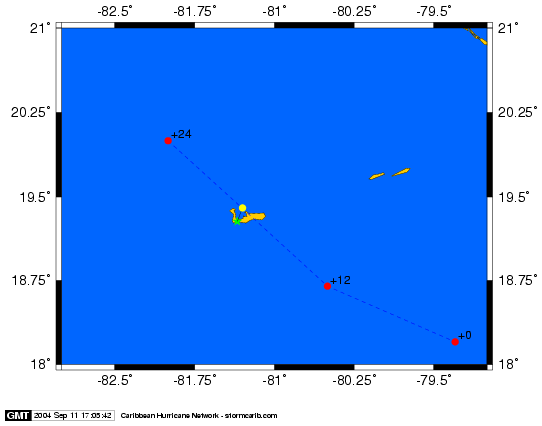
Two bad developments for Grand Cayman. 1. Ivan is again a category 5 hurricane, with 165 mph (!!!) sustained winds. 2. Earlier it looked like the eye was staying about 30 miles to the east of Grand Cayman, the 5PM forecast predicts that the eye is going to go straight over Grand Cayman... See this little map I made with the CPA calculator. The green dot is the airport on Grand Cayman, the red dots the forecast and the yellow dot roughly the Closest Point of Approach. That will be in 18 hours... For Little Cayman and Cayman Brac this is better... It now is expected to pass over the western side of the Isle of Youth and far western side of Cuba (about 95 miles from Habana).
Since the track forecasts are more to the west each time, let's hope that Ivan will go more west then expected, passing Grand Cayman on the west side... Also, hurricanes have a hard time to stay this powerful, hopefully it will weaken somewhat in the next 18 hours... It will however remain a very dangerous hurricane. Reports from the local hurricane correspondents can be found here. There is also a Plea for Help board for Cayman.
September 11, 12:40PM EDT - Cayman...
It looks like Jamaica was spared the highest winds of Monster Ivan. The eye stayed just south of the island. It is amazing on the satellite loop to see how the eye circled around, instead of over, the island. The other good thing is that not all communication is down. With Grenada earlier this week the most frightening thing was that no-one knew what was going on, other than that is was really bad, because all communication were lost. Now I have seen tidbits of info from people who have been talking to people on the island by landlines. I even got a report earlier by one of my hurricane correspondents on Jamaica. The reports can be found here. I also set up a Plea for Help board for Jamaica where people post some info.
So now the Cayman Islands are next. Did it look earlier that Cayman Brac and Little Cayman would get the brunt of the storm, now it looks like Grand Cayman is getting it after all... The latest closest point of approach (CPA) of the center of the storm for Grand Cayman Airport (located on the western side) is just 32 miles (in 24 hours). So it will be closer for the eastern side of Grand Cayman. For Little Cayman and Cayman Brac the CPA is 47 and 65 miles respectively. Reports from the local hurricane correspondents can be found here. There is also a Plea for Help board for Cayman.
Maximum sustained winds are still near 145 mph. A dangerous category 4 hurricane. It might even become a Category 5 before it reaches Cayman... The other bad thing is that the forward speed of Ivan is only 8mph, so it will take longer to pass over as well....
Last but not least... the situation on Grenada is still very bad. There infrastructure is not as hurricane-proof as on Cayman or Jamaica since they almost never get any... If you want to help, I listed many relief efforts on this page.
Fri, 10 Sep 2004 09:06:30 -0300 - Son of Gilbert?
|
Good morning!
Having received many e-mails concerning loved ones,
family and friends, especially in Grenada, I'm sorry to say I do not have direct
contact with anyone there as we receive all of our information via the
stormcarib website. Please direct your inquiries to the respective Emergency
Operations Centers in the country of inquiry or CDREA. A rather complete listing
of CDREA coordinators and contact numbers is listed on the Grenada posting of
September 9th. also, please check the Pleas for Help bulletin board on this
website as another avenue for possible contact.
I am asking all correspondents to please submit
with their postings, if possible, local numbers of their Emergency Response
Centers so that concerned relatives and friends have another option to try to
find someone in the path or wake of Ivan and any other storms. Thank you in
advance!
As far as Hurricane Ivan is concerned, I have
dubbed him "Son of Gilbert!" Referencing Hurricane Gilbert which devastated
Jamaica on September 12th, 1988, Hurricane Ivan poses a more serious threat,
especially if it is a direct hit, or even if just the northern part of the
storm, which is the strongest, passes over. Jamaican's, and for that matter,
Cayman Islanders, if you've seen or heard reports of what catastrophic damage
Ivan did to relatively unprepared Grenada, you'll understand the need to heed
your local authorities orders to evacuate or rush to completion your hurricane
preparations and then get to, or stay somewhere safe. This storm is a
life-threatening situation! I cannot stress that enough!
The possibility still exists for Ivan to strengthen
back into a category 5 before hitting Jamaica and probably will.
6-12 inches of rain are forecast for Jamaica which
will cause extraordinary flooding. In the mountainous terrain landslides,
mudslides and deforestation will occur as
the rainfall will be torrential at it's mildest. Yes, I said mildest. At
it's current 145 mph wind speed, a strong Category 4, catastrophic structural
damage will occur as well so if you are living in a place of dubious
construction, leave now and get to a shelter! It's a real possibility your
house, and unfortunately if you stay in it, maybe even yourself, will not
be around afterwards. So please judge accordingly. Houses can be rebuilt. You,
more than likely, will not be.
The Caymans are next after Jamaica although Haiti
and the Dominican Republic still will, and are, feeling the fringe effects of
this storm. Four children in the DR were drowned as a result of Ivan. Then it's
on to Western Cuba and ultimately, as the computer models are in good agreement,
South Florida following a Hurricane Charley path. But it's really the Caribbean
we are concerned about here. There's other media which can take care of the
mainland as we have discussed previously.
Bahama's, you could even get some of Ivan as it's a
huge storm in diameter, so watch Ivan's path closely. The closer to Florida's
west coast, and hopefully not the east as far as your concerned, the more
effects you will feel.
Prayers and thoughts are with all as over the next
few days, sadly, some areas of the Caribbean will look like Armageddon; just
look at Grenada and it's people if you think I'm kidding.
Dave
|
September 10, 2:30AM EDT - Jamaica...
Not much to tell... Ivan is now a category 4 hurricane, packing 145 mph winds. It is going for Jamaica. Not much weakening expected in the next 24 hours... The center is expected to make landfall at around midnight... Tropical storm winds could be felt 14 hours earlier... That is 10AM... You guys better be prepared!!! REMEMBER: Stay out of flood-prone areas, either coastal or in the hills.. Most casualties with hurricanes are due to drowning, not wind inflicted!. Find reports by the special local hurricane correspondents on the islands above. I also redesigned the Pleas for Help bulletin board. There are now different forums for each island...
September 9, 1:30AM EDT - Jamaica...
First things first... It doesn't look good for Grenada. It reminds me a lot of St.Maarten after Luis back in 1995... There are several relief efforts underway in Florida, New York, Trinidad... Also, a disaster relief fund has been set up by the Consulate General of Grenada. For more information see the Grenada Reports Webpage. I am getting flooded with e-mail from people who are worried about their family and friends on the island, who unfortunately I can't help. All info I get is published on the website. You can try posting on the Plea for Help bulletin board. You will also find more tidbits of info posted by others.
Luckily for Aruba, Bonaire, Curacao and Margarita Is. Ivan passed safely about 100 miles north of them. Of course this big category 4 hurricane, packing 145mph sustained winds did impact those islands (see some reports by the local hurricane correspondents above.
Unfortunately Grenada doesn't seem to be the only one in Ivan's destructive path. Next up is Jamaica. According to the 11PM advisories the center of the storm is expected to pass over the island in 40 hours (Friday at 3PM). Since tropical storm winds extend outward at that time to up to 175 miles, and if the storm keeps moving at 17mph, tropical storm winds will reach Jamaica around 5AM on Friday. Also, further strengthening is expected. The 2AM advisory reports that Ivan is now a category 5 (the highest category on the Saffir-Simpson Scale) with 160mph sustained winds, a so-called catastrophic hurricane... So, please, Jamaicans, don't fool around with this one. Don't hope that it will go north or something. All computer models agree pretty well on the track in the next 48 hours. You will have to be really well prepared. Just take a look at Grenada... This one is going to be way worse then Allen in 1980 or Gilbert in 1988...
After Jamaica, Ivan is expected to move over the Cayman Islands. Especially the most north-eastern island Cayman Brac is in the danger zone. It's closest point of approach is calculated at just 48 miles in about 65 hours (Saturday 9/11, 4PM). Tropical storm winds will be felt Saturday morning. Since it is a bit further in the future, the forecasted track has more uncertainty. Meaning that it might get even closer. All of Cayman should prepare for the worst. No kidding with a Category 5 storm!.
Then as it looks right now the storm will pass over western Cuba, and maybe into Florida (about the same track as Charley...).
Stay tuned to this website for updates from the islands... Do you live on the Caribbean, and want to join the network of local hurricane correspondents, e-mail me at gert@gobeach.com.
Finally, a big thank you to my service provider Pair.com, who moved my website graciously to a dedicated server to handle the traffic! Yesterday alone this website got almost 2 million hits, and used about 50 Gbytes of bandwidth... If you are ever looking for a webhost..., they are the ones!
Wed, 8 Sep 2004 11:49:59 -0400 (AST) - Ivan and Beyond
Good morning!

My sympathies and prayers to those devastated by the passage of Ivan the
Terrible. Grenada's direct hit and subsequent cut-off from all
communications, save for a few lucky cell phones, make for many
apprehensive relatives not in harms way. We will try our best to keep you
updated as this tragic situation unfolds and more reports are forthcoming.
Please don't expect rapid re-establishment of communications as the
islands infrastructure has taken a massive blow.

This also is in reference to, although on a less devastating note, the
islands of St. Vincent and the Grenadines, Trinidad and Tobago, Mustique,
Barbados, St. Lucia and so on, including the ABC islands which haven't
felt the direct blow of a hurricane in, I believe it's 127 years!

Hurricane Ivan's projected path now takes it across Jamaica, Caymen's, the
Isle of Youth and Western Cuba; then continuing up Florida's west coast,
ala Charley. At least that's the official forecast and the National
Hurricane Center has been pretty accurate so far in their 6 hour
predictions. As a side note, I believe the Isle of Youth south of Western
Cuba, has been hit the most over the last few 2-4 years. Amazing for such
a small island to be repeatedly threatened, and hit, by these storms.

I would like to thank everyone for their support for my comments on
tropical information, or lack thereof, from local governments and national
medias like The Weather Channel here in the Caribbean. Please forward your
comments to weather.com  at the What do you think section and your local
government agency or media as well. Maybe, together, we can all make a
difference.

Hurricane Ivan is nothing to be procrastinating about. If you lie in
his path, take the necessary precautions ASAP. This is a dangerous system
and nothing to play around with and "hope for the best."

Dave
September 8, 2AM EDT - Grenada
The eye of Ivan passed over Grenada... First reports from Grenada don't sound too good... Let's hope for the best... The other islands, except probably for some of the Grenadines, seemed to have fared ok (see above).
Ivan (now a category 4 hurricane) will pass about 100 miles north of the ABC Islands (Aruba, Bonaire and Curacao), well outside the range of hurricane strenght winds (70 miles) but they will get tropical force winds. Same for Margarita Island, Venezuela. (see some updates above). Hopefully Ivan doesn't drift south because it might become even stronger and reach the highest category on the saffir-simpson scale...
Then it is on to Jamaica (eye will be there in about 2½ days) and Cayman's.... Use the tools above to calculate how close the storm can get to your locations....
Older weather discussions on Ivan have moved to another page.
| - - - Alex, Bonnie, Charley, Danielle, Earl, Frances - - - |
Weather discussions on these storms have moved to another page.
| - - - Local hurricane correspondents wanted! - - - |
Do you live on one of the islands? We need your help! We are looking for more people who are interested in sending us a few paragraphs about the situation on your island before, during and after a storm hits. You don't need to be a weatherman or expert on the subject, just share with us what you know, feel and see on your island. Your help will be really appreciated by Caribbean people living abroad with family living on the islands, future visitors who have their Caribbean dream-vacation booked, etc.etc. Reliable, not-sensationalized information is just so hard to get in crisis situations. Help keep the rest of the world up-to-date with what is really happening! We really need you, Georges is proof! If interested, contact gert@gobeach.com.
|
GoBeach Vacations |
| Back to top |