- Updates from the Islands -

- - Trinidad & Tobago - -

| home | tools | pleas for help | QHWRN | guide | climatology | archive

- - - 2004 Hurricane Season - - -

- Yeah Gert!
  • From: "Robert & Colleen Krucia" <rnckrucia AT wow.net>
  • Date: Sun, 8 May 2005 18:57:45 -0400
Hey Gert,
              Just realised you made the 2005 hurricane name list!  Congratulations!! :-) Now if you get up to bat, be nice to us puh-leeeeze? LOL Well, here they are just for information sake then.
 
2005 names:
Arlene
Bret
Cindy
Dennis
Emily
Franklin
Gert
Harvey
Irene
Jose
Katrina
Lee
Maria
Nate
Ophelia
Phillipe
Rita
Stan
Tammy
Vince
Wilma
No virus found in this outgoing message.
Checked by AVG Anti-Virus.
Version: 7.0.308 / Virus Database: 266.11.2 - Release Date: 5/2/2005

- 2005 hello.
  • From: "Robert & Colleen Krucia" <rnckrucia AT wow.net>
  • Date: Sun, 8 May 2005 18:29:11 -0400
Hello Gert and everyone else for 2005. It's been a very interesting beginning to this year. Our "dry" season has been anything but dry and thankfully the bush fires have been few in numbers again this year. I don't have rainfall figures but I am sure they are interesting reading. Last year's dry season was similar and I am already wondering if that means the severity of the coming hurricane season will be a repeat of 2004.
 
Our disaster preparedness status in Trinidad continues to be a disaster. A major fire in Port of Spain last month is enough evidence of that. Thankfully that has brought the problem to the forefront somewhat but as usual, the politicians "politick" with the issue and in the end nothing is accomplished except that they find a way to make mileage for themselves. Chups.
 
Can you imagine with the crime situation being what it is, what would happen if we had something major happen now? Not a good outlook at all. It's necessary for me to keep reminding myself God is still in charge. It's also comforting to remember we all will have to give account for our stewardship when we stand before Him back in eternity.
 
May Our Lord Jesus Christ bless and keep all of us in this coming season of "large counter-rotating winds".
 
Bye for now.
Robert Krucia
Port of Spain.


No virus found in this outgoing message.
Checked by AVG Anti-Virus.
Version: 7.0.308 / Virus Database: 266.11.2 - Release Date: 5/2/2005

- Contents of Word Document posted by i9y4ibn
  • From: Gert van Dijken <gert AT vandijken.com>
  • Date: Fri, 3 Dec 2004 14:26:34 -0500 (EST)

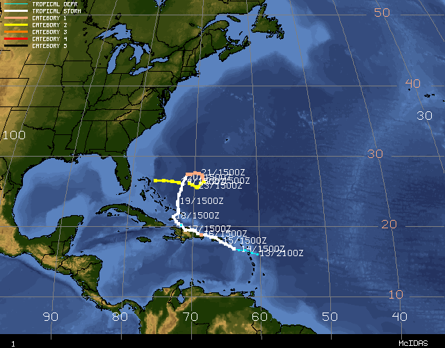
For those who are a little hesitant to open Word documents from 'unknown'
people... Below the text of the document submitted by i9y4ibn below
regarding the Earthquake.  -Gert


Earthquake near the east coast of Trinidad

St. Augustine, Trinidad and Tobago, W.I. --December 3rd, 2004, 1:00PM --
On Thursday afternoon December 2nd, at 3:16 PM, an earthquake occurred
inland near the east coast of Trinidad about 30 km south-east of Port of
Spain. This event was of magnitude 5.4 and was widely reported as felt in
St. Vincent, Carriacou and throughout Trinidad as well as some areas in
Tobago. There have been over 90 aftershocks following the event with the
strongest aftershock (magnitude 5.1) occurring at 11:46 PM on Thursday
evening.
The 3:16PM event was reported felt throughout Trinidad, including Diego
Martin, St. Augustine, San Fernando, Carapachima, and Point Galeota.
Reports from Mayaro describe strong shaking. The 11:46PM aftershock was
reported felt in Cocorite, Tunapuna, Chaguanas and San Fernando.
Scientists at the Seismic Research Unit have described these as
moderate-sized earthquakes. There have been no reports of injuries and one
report of cracks in a factory wall in St. Joseph. The last event of
similar magnitude was recorded on May 3rd, 1994 when an earthquake of
magnitude 5.5 occurred off of the east coast of Trinidad. That event was
offshore and aftershocks from the earthquake lasted for approximately four
weeks. The last earthquake to cause damage in Trinidad was in 1968 and the
last one to cause death was in 1954. These events were both of magnitude
6.2. In 1997 a magnitude 6.1 earthquake caused structural damage in Tobago
and two people were injured.
The cause of these earthquakes is unrelated to weather conditions; rather
earthquakes are caused by the movement of plates. The Earth is divided
into plates (slabs of rock), which are constantly moving. The region where
these plates meet is called a plate boundary. The Eastern Caribbean is an
example of an island arc system formed at a convergent plate boundary
(more specifically, at a subduction zone, where two tectonic plates meet
and the denser plate is forced beneath the lighter plate). This is the
main cause of the volcanic and seismic activity in the Eastern Caribbean.
Most of the earthquakes occurring in the Eastern Caribbean are either
tectonic or volcanic in origin. Tectonic earthquakes are generated when
plates move as accumulated energy is released. Volcanic earthquakes are
generated by the movement of magma within the lithosphere.
The recent earthquakes in the region affecting Dominica, Guadeloupe, and
Central America, Trinidad and Tobago have all been tectonic and are not
related to volcanic activity. Although the earthquakes have been caused by
the same process they are not related in the sense that one has not
triggered the other. Scientists are still working to understand why these
events are occurring in succession.
While the December 2nd earthquake has placed much attention on Trinidad.s
vulnerability to earthquakes it is worthwhile to note that long after the
memory of this event has faded Trinidad will continue to have earthquakes
that go unnoticed. There are hundreds of earthquakes occurring near
Trinidad each year with an average of five to seven of them being felt.
Understanding our vulnerability to these events and being prepared for
earthquakes is, therefore, of utmost importance. Here are some tips on
what to do before and during an earthquake:
Before
. Become actively involved in community preparedness organisations in your
district. Call NEMA for contact information.
. Unstable, heavy furniture should be fastened to a wall or bolted to the
floor. When loading storage cabinets heavy objects should be placed on
lower shelves.
. Water heaters and other appliances should be firmly bolted down.
. All family members should know how to turn off electricity, gas and
water using safety valves and main switches.. Family members should know
basic First Aid steps.
. Purchase emergency equipment such as battery-operated radios and fire
extinguishers for your home.
. Always have non-perishable food items in stock.
During
. Do not panic, stay calm.
. Always protect your head and face.
. If inside a building, stand in a strong doorway, or get under a desk,
table or bed. Do not try to run out of the building as you can be injured
by falling debris.
. Move away from outer walls, windows, glass doors, heavy mirrors,
pictures, bookcases, hanging plants and heavy objects.
. Look out for falling plaster, bricks, lighting fixtures and other
objects.
. Do not use elevators.
. If you are outside, stay there. Stand away from buildings, trees, and
electricity lines.
. If you are driving, you should safely bring the vehicle to a stop away
from electricity poles and overhead wires. Remain in the vehicle.


*
**
*** Gert van Dijken ( gert@vandijken.com )
**** Caribbean Hurricane Network - http://stormcarib.com/


- Document1
  • From: "i9y4ibn" <i9y4ibn AT carib-link.net>
  • Date: Fri, 3 Dec 2004 15:26:13 -0400
 

Doc1.doc

- Earthquake
  • From: "adesh nanan" <adeshcnanan AT hotmail.com>
  • Date: Fri, 03 Dec 2004 04:24:00 +0000
Hi Gert,

I was swaying to and fro by a strong tremor that lasted approximately 15 
seconds.My location is in Palmiste Trinidad .This is more to the south west 
of the island. This is probably around a 6.0 in magnitude at 11.58 pm on 
Thursday 2nd December.

Dr Adesh Nanan

_________________________________________________________________
Express yourself instantly with MSN Messenger! Download today it's FREE! 
http://messenger.msn.click-url.com/go/onm00200471ave/direct/01/


- Document1
  • From: "i9y4ibn" <i9y4ibn AT carib-link.net>
  • Date: Thu, 2 Dec 2004 17:15:27 -0400
 

Doc1.doc

- persistent thundershowers
  • From: "adesh nanan" <adeshcnanan AT hotmail.com>
  • Date: Fri, 12 Nov 2004 07:49:57 +0000
Hi Gert,

Presently heavy rainfall in palmiste,southwest Trinidad.Loud thunder 
overhead and severe lightning illuminating up the western sky.Satellite 
picture shows large band of clouds over the island.

Dr Adesh Nanan

_________________________________________________________________
FREE pop-up blocking with the new MSN Toolbar - get it now! 
http://toolbar.msn.com/


- Update
  • From: "adesh nanan" <adeshcnanan AT hotmail.com>
  • Date: Thu, 21 Oct 2004 09:27:20 +0000
Hi Gert,
I was surprised to hear thunder and heavy rainfall overhead.My location is 
in Palmiste,Trinidad .This is more to the Southwest on the island.
Presently the rain is subsiding and the thunder is in the distance.There is 
a slight breeze and  the morning is cool.
Satellite imagery shows a system moving from Southwest to 
Northeast,apparently arising over the SouthAmerican mainland.
Weather can be very unpredictable!

Dr Adesh Nanan

_________________________________________________________________
Don't just search. Find. Check out the new MSN Search! 
http://search.msn.com/


- Unusual Weather pattern
  • From: "adesh nanan" <adeshcnanan AT hotmail.com>
  • Date: Fri, 08 Oct 2004 12:48:50 +0000
Hi Gert,

The temp is 77F, pressure 29.88in and rising,wind calm .
There is an unusual weather pattern affecting the island of Trinidad that 
caused heavy rainfall with flooding yesterday.Today the trough continues to 
exist pulling moisture from the south american mainland just west of the 
island.
If this system shifts further to the east there will be heavy rainfall 
concentrated in the southwestern part initially and then more to the 
northeast.
More localised flooding can be expected

Dr Adesh Nanan

_________________________________________________________________
STOP MORE SPAM with the new MSN 8 and get 2 months FREE* 
http://join.msn.com/?page=features/junkmail


- Tropical Wave watch!
  • From: "adesh nanan" <adeshcnanan AT hotmail.com>
  • Date: Sun, 03 Oct 2004 13:53:29 +0000
Hi Gert,

In Palmiste,Trinidad  the temp is 73F, pressure 29.91in steady,    wind 
speed 7mph ssw.
Currently there is the rumbling of thunder overhead with a light drizzle.The 
satellite picture shows the remnants of a tropical wave affecting the 
island.The ground is saturated now and any continuous heavy rainfall will 
lead to more intensive flooding.
However what is ironical is that many farmers are happy for this weather 
because it has been very dry here .
In the low lying areas there are reports of floodiing .
Again there is a need to be always on the alert because this was just a 
tropical wave and there was widespread flooding

l Dr Adesh Nanan

_________________________________________________________________
The new MSN 8: advanced junk mail protection and 2 months FREE* 
http://join.msn.com/?page=features/junkmail


- Heavy Rainfall
  • From: "adesh nanan" <adeshcnanan AT hotmail.com>
  • Date: Sat, 02 Oct 2004 19:10:08 +0000
Hi Gert,

Presently in Palmiste,Trinidad the temp is 75F,pressure 29.85 in,wind NE 
8mph.There is light rain with thunder.A few hours ago,there was heavy 
showers with gusty winds.
The concentration of the rainfall was in the South of the island and there 
are reports of flash flooding in low lying areas.
This weather is associated with a tropical wave that is passing more to the 
South West of the island.


Dr Adesh Nanan

_________________________________________________________________
MSN 8 helps eliminate e-mail viruses. Get 2 months FREE*. 
http://join.msn.com/?page=features/virus


- Dyslexic
  • From: "Robert & Colleen Krucia" <rnckrucia AT wow.net>
  • Date: Sat, 25 Sep 2004 16:03:49 -0400

Looking at Jeanne’s path it shows she is dyslexic.


---
Outgoing mail is certified Virus Free.
Checked by AVG anti-virus system (http://www.grisoft.com).
Version: 6.0.768 / Virus Database: 515 - Release Date: 9/22/2004


- Lisa?... manners?
  • From: "Robert & Colleen Krucia" <rnckrucia AT wow.net>
  • Date: Fri, 24 Sep 2004 14:13:32 -0400

Hi everybody,

                       I see posts from stricken islands have begun to appear steadily. That’s a good sign. The photos and videos are astounding. I wish more Trinidadians could see them. The pure danger of storms is so evident.


Haiti is heartbreaking. Couldn’t believe the behavior on the news (TV) last night for food… sad, really sad.


                       Is Lisa showing some manners and waiting for Jeanne to exit center stage? Lisa is “lay-layin” as we say here in Trinidad, meaning to lurk, await an opportunity or one’s turn. This could go either way (I think).


                       At present in Trinidad we’re having some “unrelated weather”. Earlier this morning was pretty clear with a steady Easterly, approx 12-15 km/hr (estimated). I planned to go fishing but one buddy called sick (barely had a voice) and one just did not show. He called later to apologize, overslept. I had a headache, so I’m not too sorry. It’s been raining for the last hour and a half or so. Lots of thunder in the distance. Yesterday I went to Chaguaramas and the Gulf looked a bit “lumpy”.


                       Now the wind has picked up a bit, more northeasterly and looking more like 20 km/hr (approx) with higher gusts. Curiously the Atm. Pres. has risen since last night to about 1026mb. I think my hobby thingy might be very off, but the pressure is higher than last night, so now I really want a proper weather station.  Temp 85 F and humidity 65%. I will be comparing these readings over the next few days just in case Lisa “drifts” this way. The past few days have seen 95 F temperatures. Pretty awful.


                       Looking at Jeanne, is there a chance she might cut across Florida’s midsection and go into the Gulf of Mexico? Then Texas ……? Who knows?


Later for now.

R.K.

Port-of-Spain.


---
Outgoing mail is certified Virus Free.
Checked by AVG anti-virus system (http://www.grisoft.com).
Version: 6.0.768 / Virus Database: 515 - Release Date: 9/22/2004


- Catnapping
  • From: "King's Hardware Ltd." <kings AT wow.net>
  • Date: Wed, 22 Sep 2004 15:08:54 -0800
Lisa is exhibiting the characteristics of a fickle feline. The kind that does a lot of damage. Hence the lack of steady direction. Not sure I like that.
 
The would-be system behind her probably has her by the tail so that's making her do crazy things ya?
Ivan's leftovers warming up and Jeanne is backtracking (?), what a season.
 
 
R.Krucia
Trinidad.

- The Storm Machine
  • From: "adesh nanan" <adeshcnanan AT hotmail.com>
  • Date: Wed, 22 Sep 2004 01:07:28 +0000
Hi Gert,

The sky is  mostly clear, the temp is 81F, there is a 15mph South Wiesterly 
wind in Palmiste ,San Fernando.
Once again we have to be on our guard as erratic Lisa approaches the 
islands.There are too many variables  as the forecast is changing daily.One 
model shows this storm taking a south westerly course bringing Tobago into 
the picture.
Hot on the heels of Lisa is probably Matthew that may take a more southerly 
track .This is a very large disturbance at present and can be a very large 
storm.
It appears that the storm machine is working overtime, since graphically we 
should be tapering off.
I hope that there  will be adequate warning if it becomes necessary.
Nevertheless there is an old folks saying" when your calves paining you 
storm coming".

Let us pray for our islands!


Dr Adesh Nanan

_________________________________________________________________
MSN 8 helps eliminate e-mail viruses. Get 2 months FREE*. 
http://join.msn.com/?page=features/virus


- "And the beat goes on."
  • From: "Robert & Colleen Krucia" <rnckrucia AT wow.net>
  • Date: Tue, 21 Sep 2004 00:07:45 -0400

Here comes the next wave, time to dig in again (yes start planning now, not when they’re off Tobago).


Area of disturbed weather approximately 10 deg N, 30 deg W is very large, of more concern is that it is also very South and has good potential for development.


At this longitude Ivan was not much different in Latitude. I will be keeping a very close eye on this one especially if it qualifies to be called Matthew in the next 24 to 36 hours. Lisa could be a problem for the more northerly islands, I’m guessing from Guadeloupe and further north. Barbados may not be out of this either.


 Look  lively mateys, it’s not over till it’s over.  Looking at the sat pics of Western Africa, there’s a procession coming off the continent and it looks like they’re lining up to shoot us down, start praying hard.


R. Krucia

Trinidad.


---
Outgoing mail is certified Virus Free.
Checked by AVG anti-virus system (http://www.grisoft.com).
Version: 6.0.738 / Virus Database: 492 - Release Date: 8/16/2004


- Sat 18 th Sept 2004.
  • From: "Robert & Colleen Krucia" <rnckrucia AT wow.net>
  • Date: Sat, 18 Sep 2004 23:08:56 -0400

Hello to everyone,

                         Yesterday afternoon produced a heavy rain shower that flooded Port of Spain and surroundings again including around the Savannah, Mucurapo Road, South Quay and Wrightson Road. The thunderstorm lasted only about twenty minutes to half hour. This “deluge” was short and intense with lots of lightning, the thunder less than a second later crashing around us for about ten minutes.


Many taxi drivers immediately stopped work resulting in people having to walk home or stand on the roadside waiting for transportation late into the evening hours.

I had to go downtown Port of Spain to look for a family friend and get her because transport was impossible. Frederick Street was not too bad by then with traffic. But many many people were waiting on taxis. One lady told me she saw a banana tree among other debris on Mucurapo Road washed down from the hills. In time to come it will be much more than banana trees.


Today there was an extremely heavy midday shower with a lot of wind out of the north but not as bad as yesterday. No floods reported as yet. As I write this I hear thunder in the distance. There is rain to the south-east of the island again. Perhaps Central will be spared the floods today?

It has “felt” uncomfortably hot and humid these last few days. I’m guessing all that hurricane activity to the north may be drawing equatorial heat from South America over us, just my wild guess.


News from Tobago indicates a notable amount of damage from Ivan but nowhere near the scale of Grenada’s. They will recover relatively quickly.

The flow of supplies to Grenada from private citizens here continues.


There was a news item on TV last night about locally grown food prices. Farmers here are claiming major crop losses due to heavy flooding in the past weeks. Demand is outstripping supply so there are large price increases averaging about forty percent for various vegetable items this week. Next week will be another matter. More thunder in the distance, louder and longer this time. I doubt the boats from Grenada or St. Vincent came this week with ground provision, mauby bark, conch and lobster. It would be encouraging to see that resume again if only for Grenada’s sake for what it would imply. I will try to find out more next week about what is happening with this. It will be a good indication of their status.


A sat loop from NOAA this afternoon shows Jeanne doing some funny things right between Puerto Rico and Hispaniola. The NHC is giving the storm’s position as north of the island but there is so much going on all around. Can anyone explain this?


I’m considering installing a weather station. What I have now is a simple tri-gauge showing temperature, humidity and barometric pressure. A more advanced system with optional computer interface would be nice but I feel the system would be better if it had stand alone capability just in case. Would anyone care to recommend a good option for novices like me?


8 hours later.


I had a late lunch and a nap. Tonight is cooler. It’s time to post this.


Bye for now,

Robert Krucia


---
Outgoing mail is certified Virus Free.
Checked by AVG anti-virus system (http://www.grisoft.com).
Version: 6.0.738 / Virus Database: 492 - Release Date: 8/16/2004


- Eyes on Tropical Storm Karl
  • From: "adesh nanan" <adeshcnanan AT hotmail.com>
  • Date: Fri, 17 Sep 2004 13:42:45 +0000
Hi Gert,

Currently the temp is 88F, 29.94 barometric pressure and wind 7mph westward
Today all eyes are focussed on Tropical Storm Karl in the Atlantic.The 
forecast track is to turn to the North away from the islands.
This storm is forecasted to become a Hurricane later today.
Yesterday there was some heavy rainfall in the Central area of Trinidad and 
there was localised flooding.This is a serious problem in the low lying 
areas that must be addressed
The issue of adequate hurricane shelters should be high priority at this 
time too .Trinidad was lucky to escape Hurricane Ivan and we need to 
establish adequate emergency shelters.To identify every school and community 
centre is not good enough.A number of schools and community centres are 
inadequate to withstand heavy winds.
There is also a requirement to provide food and cots with blankets .
These were sadly lacking when Ivan was threathening.
I do hope that we have learnt our lesson and will be better prepared in the 
future.
As Karl is still 1900 miles away,it all depends on the low pressure that is 
to form in the Central Atlantic.If this does not shift Karl then the lesser 
Antilles could be in for another major Hurricane.
We need to be properly prepared
This is a matter of survival


Dr Adesh Nanan

_________________________________________________________________
The new MSN 8: smart spam protection and 2 months FREE*  
http://join.msn.com/?page=features/junkmail


- Mmmmm...much food for thought.
  • From: "Robert & Colleen Krucia" <rnckrucia AT wow.net>
  • Date: Fri, 17 Sep 2004 01:25:39 -0400

I see we have a few new correspondents. Welcome and hello to all. It’s been difficult to decide what to put here with so much going on. Charley, Frances, Gaston, Hermine, Ivan… now Jeanne and also a system to the East with a chance of becoming Karl. Does anybody really believe this is all “just a phase”? A freaky climatic cycle? I don’t believe in co-incidents and this is waaay beyond that. Co-incidents speak of two… anybody still counting?  Don’t say anything about global warming either, that does not add up to all this.


This afternoon we had some heavy showers in Trinidad and much lightning to the north reminiscent of what became Charley just over a month ago as that system passed by early one Monday morning. I remember writing about that in an earlier post. I’m not even going to look at the sat pics to see what it was. The social impact of this yet unfinished hurricane season is incalculable. Then there’s the financial and economic after effects, all to come.

Florida is looking at possibly hurricane hit #4 in a few days over what… six weeks? I was tempted to call her Meanne Jeanne, but with all that has gone on “Obscene Jeanne” would be much more appropriate.


The next few years will spell extreme difficulty for many of our Caribbean nations and I mean including ones who have not been hit by hurricanes. The economic impact will be very significant. I see food and prices becoming an issue, unemployment, debt repayment delinquency, more uneducated youth, more crime, more AIDS, more immorality. More in-humanity from man to man, a time of hardship, refugees, island hopping, people seeing the grass greener on the other side of the fence.


We are going back forty years optimistically.


The Windward Islands may be “up to bat” next if Karl is born of TD 12.


By the end of this remarkable season it’s already obvious that no part of the Caribbean will be untouched in some way by the 2004 hurricane season.


My past laments of Trinidad’s predicament regarding disaster (un-)preparedness are now even more troubling with Grenada’s catastrophe for a “live preview”. Theirs is a small example of what Trinidad would be like in the event of such a disaster, unprepared and ripe for destruction. Now evident is what will come after: the chaos, the looting, the crime, which presently is our own already ongoing catastrophe. Leadership is already at its worst.

Example? Today’s newspaper. Two big hardback men in the highest house in the land and this is the level of conduct.


One Minister, “He hit me! He’s a racist!”

Reply… “ He lie! I didn’ hit him. He is the racist!”

Last time I heard that kind of talk was in primary school.

“He say, she say, dem say, I say….”, and the people are watching. Some think it is funny and will follow their destructive path. Chups, I sound like a prophet of doom and gloom, but anybody with eyes could see.


Now the politicians are talking about helping the hurricane hit islands…… a WHOLE week later! They are still talking. Meanwhile citizens here who have the means since last week, just after Ivan hit, with anything that will float and make it to Grenada have been taking supplies over. These people are heroes! I urge Grenada never to forget them. They risk their very lives to do this. It brings to mind… “No greater love hath any man than he who will give his life for a brother.” I also very much like here the sayings, “Less talk, more music” and “What you’re doing speaks so loudly I can’t hear what you’re saying.”


This is getting very long and I want to end. I was not here for the threat of Ivan but the reports I have been getting have been horrendous. Many people did not know a thing until the last minute. Many people would not have been ready for a major disaster. A friend reminded me that while away, I spoke with him many days before the threat and told him to “watch Ivan carefully, it was so far south”. I had forgotten about that.


People had actually gone to work that morning! They were then advised to go home around 8.30 am after getting drenched on the way. You want to know what is now even more frightening. NO-ONE has said a thing! No one realizes how close we came and God spared us again. No shutters were up. No “masking tape on the windows” even.  But the lesson was closer than ever this time, next door.

That tells me, our turn may not far in coming.


We all will have to give account to God for what He has entrusted us with.

I say nothing at this time to those who have suffered such great loss as much as I want to say something. It’s too likely they may never read this. No power, no computers, you know?

As I flew home last Saturday night I looked out the aircraft window where Grenada should be. I was used to seeing her lights. Instead, I saw a couple ships… and total darkness.


Bye for now.
Robert Krucia

Trinidad.


---
Outgoing mail is certified Virus Free.
Checked by AVG anti-virus system (http://www.grisoft.com).
Version: 6.0.738 / Virus Database: 492 - Release Date: 8/16/2004


- Update on Hurricane Ivan's impact on Grand Cayman
  • From: "adesh nanan" <adeshcnanan AT hotmail.com>
  • Date: Sun, 12 Sep 2004 16:07:16 +0000
Hi Gert,

Just wanted to give and update from Trinidad.
Just spoke to a friend and he said the the water on the road along the Seven 
Mile beach is 8 feet and rising
The Hospital Car park is under water and the cars are floating away.
The wind continues to howl like a freight train !
The situation on the island is very bad
We are all praying here


Dr Adesh Nanan

_________________________________________________________________
MSN 8 helps eliminate e-mail viruses. Get 2 months FREE*. 
http://join.msn.com/?page=features/virus


- 090904 - Grenada Report Sept 09 21:30 hours
  • From: "Dennis Bally" <dbally AT tstt.net.tt>
  • Date: Thu, 9 Sep 2004 21:39:43 -0400
 
Report from Trinidad, West Indies, 
Re GRENADA, W.I.
21:30 hours 2004 Sept 09
The Sources for my reports come from telephone communications between Grenada and Trinidad, and Radio Reports. I reside in Trinidad, W.I.
 

Hurricane Ivan has left Grenada devastated!

Various reports from Grenada have stated that the number of deaths due to Hurricane Ivan now stands at 8.

90% of the island is reported to have been demolished by Ivan.
Buildings have been flattened and/or their roofs blown away by the force of Ivan's winds which have been said to have reached strength of approx. 90 mph. Major buildings and Public facilities have been damaged.
The Nutmeg plantations which is a major income earner for Grenadians have been flattened.
Electricity, Water and Telephone communications are out in the majority of the island. Limited cell service is available.
Further damage assessments are currently in progress.
Looting is a major concern. People are trying to secure their possessions.
Law and Order needs to be restored.
Volunteers are concerned re their safety whilst in Grenada.
Their Prison was demolished and the prisoners are now "on the loose".
A State of Emergency may have to be declared.
There are constant requests over the radio stations in Trinidad for Public assistance in providing relief items for Grenada. Some of the requested items are:
Plastic sheeting, canvas, tarpaulins, tents, lumber, nails, roofing sheets, generators with fuel, bottled water, clothing, diapers, blankets, bed sheets, cots, non-perishable food stuff etc etc. Shed #3 at the Port of Spain, Trinidad Docks is the NEMA collection point for donations of relief supplies.
Various other collection and shipment points are available in Trinidad.
Relief supplies have been moving to Grenada and guidelines have been issued regarding these shipments.
Money donations in Trinidad and Tobago can be made at any Republic Bank to the Trinidad and Tobago Red Cross Account # 180463484801.
 
LOCATION OF RELATIVES AND FRIENDS IN GRENADA:
I have had several requests from relatives and friends of people who are in Grenada regarding their well-being after Ivan. Currently this is extremely difficult in view of the situation in Grenada. Please bear in mind that there are also electricity problems on the island. If the T&T Amateur Radio Society establishes a system for doing a people location/search I will advise you. Communications persons and other volunteers are concerned regarding their safety and well-being in Grenada in view of what is currently happening.
*************************************************************************************************
ISSUED BY: Caribbean Disaster Emergency Response Agency (CDERA)
DATE: September 8, 2004
TIME: 10 pm
SITUATION REPORT #4 - HURRICANE IVAN IMPACT ON GRENADA
9. CDERA is coordinating with the International Federation of the Red Cross information on the health and welfare of residents and visitors to Grenada. This information is to be posted on at www.cdera.org
**********************************************************************************
ALSO:
Go into:
click on:
PLEA FOR HELP
and:
Are you looking for someone? Need some specific information? You can now post your Plea for Help on this Bulletin Board (click on New Topic). For best results be as specific as possible, and use a good subject heading by including which island/part of island.
********************************************************************************************
.
Taken from CDERA:
Two radio stations have come to the rescue of Grenada to fill the void left by the absence of the Grenadian broadcast media.

The Caribbean Broadcasting Corporation, headquartered in Barbados, has expanded its 900 AM service to broadcasting to Grenada, at the direction of the Cabinet of Barbados. It is boosting the power of its transmitter to effectively cover the entire island. CDERA will be feeding all official information through CBC 900 AM to residents of Grenada and its dependencies. CBC has also established a toll free number for Grenadians to telephone the station and broadcast messages to their relatives and friends. The number is 1-800-744-8222.

In Tobago, Radio Tambrin will also be broadcasting official information to Grenada and its dependencies on the FM frequency on 92.1 FM.

The Department of Disaster Management in the British Virigin Islands is providing a team of technical and support personnel and equipment to establish an FM radio station. Work starts tomorrow.

Some Cable and Wireless and Digicel cell phone service is available and some landlines are operational. Digicel Barbados Limited is on the ground doing an assessment of damage to cell phone towers and devising a method to re-establish communication across the island in the shortest possible time.

********************************************************************************************************************************************************
According to our information Hurricane Ivan is now at Category 5 and it is anticipated to hit Jamaica at approx 2.00 pm on Friday 2004 September 10. We want to wish them the very best.
 
End.

- 090804 - Report From Trinidad, WI - Sept 08 14:00 hours
  • From: "Dennis Bally" <dbally AT tstt.net.tt>
  • Date: Wed, 8 Sep 2004 13:53:34 -0400
Title: Kodak HTML Email
 
Report from Trinidad, West Indies, 
The North Western Diego Martin Area
14:00 hours 2004 Sept 08
 
TRINIDAD:
The sky remains cloud covered where I am but it is fairly bright at this time and we have not had any further rain.Some flooding has taken place in Central Trinidad.
A constant medium breeze continues to be experienced here in the Valley.
Schools in Trinidad have reopened today.
Business places have reopened today in Trinidad.
 
TOBAGO:
It has been reported that 20 villages in Tobago have suffered various forms of damage. Damage was sustained to 45 residences (mainly roofs blown off).
Tobago schools remain closed until maybe Thursday.
Approx. 300 persons are still seeking emergency shelter in Tobago.
One life was reported lost in Tobago due to a falling tree.
Relief supplies have begun to arrive in Tobago from Trinidad.
First Ferry service will leave Trinidad at 2.00 pm today. Airport only available for emergency flights at this time.
The road to Bloody Bay remains impassable.
Electricity and Telephone in some areas remain out of service.
A  Relief Collection Depot has been organised by NEMA in Trinidad to receive items needed by Tobago and Grenada. Basically clothes, plastic sheeting, canvas/tarpaulins, galvanise, nails, lumber, foodstuff/canned goods, bottled water etc etc.


- 090804 - Report From Trinidad, WI - Sept 08 10:00 hours
  • From: "Dennis Bally" <dbally AT tstt.net.tt>
  • Date: Wed, 8 Sep 2004 10:19:10 -0400
Title: Kodak HTML Email
 
Report from Trinidad, West Indies, 
The North Western Diego Martin Area
10:00 hours 2004 Sept 08
 
Good Morning.
Throughout last night and up to a little while ago we were experiencing intermittent rains with heavy gusting winds. The hugeness of Hurricane Ivan can account for this continuing weather pattern. The sky remains cloud covered but it is fairly bright at this time.
Reports coming in indicate heavy rains with gusting winds continue to be experienced in the Northeast part of Trinidad.
A constant medium breeze continues to be experienced here in the Valley.
Some debris has been reported on the roads.
We lost electricity for approx. one hour this morning.
The airports in Tobago and Trinidad have both been reopened. I can hear aircraft passing over the Valley.
Schools in Trinidad have reopened today. Perhaps in retrospect they should have remained closed until tomorrow.
Tobago schools remain closed until maybe Thursday. Approx. 300 persons are still seeking emergency shelter in Tobago.
One life was reported lost in Tobago due to a falling tree.
Business places will re-open today in Trinidad.
A  Relief Collection Depot has been organised by NEMA to receive items needed by Tobago and Grenada. Basically clothes, plastic sheeting, canvas/tarpaulins, galvanise, nails, lumber, foodstuff/canned goods, bottled water etc etc.
Grenada appears to have been hit hard from all "live" reports. Three lives reported lost due to Ivan. Property damage is reported to be very extensive in Grenada. Cellular telephone service appears to be operational.


- 090704 - Report From Trinidad, WI - Sept 07 23:15 hours
  • From: "Dennis Bally" <dbally AT tstt.net.tt>
  • Date: Tue, 7 Sep 2004 23:14:26 -0400
Title: Kodak HTML Email
 
Trinidad, West Indies, 23:15 hours Sept 07:
Report from The North Western Diego Martin Area, Trinidad, West Indies:
TOBAGO
All advisories have been removed from Tobago.
Tobago begins to assess the storm damage which relates mainly to property damage and which it is said will run into $$millions.
No loss of life or injuries have been reported.
It has been reported that some areas in Tobago remain without Electricity and Telephone communications this evening.
Schools will remain closed on Wednesday and perhaps even Thursday. The schools were reported to have been used as emergency shelters which will not be shutdown until Wednesday and therefore unavailable for regular classes. Business places should resume normal activities and/or cleanup operations.
We currently only have one of the two ferries between the islands in operation and it is felt that this may result in delays in getting re-building materials and other requirements to the sister isle expeditiously.
Crown Point Airport remains closed until minimum 06:00 hours Wednesday 2004 September 08 when the situation will be re-assessed.
NEMA will maintain some activity in Tobago.
 
TRINIDAD
All advisories have been removed from Trinidad.
Emergency operations/systems have been stood down.
Earlier this evening we experienced some thunderstorm activity with high gusting winds coming in from the South South-East.
There is currently a steady light breeze which has cooled off the evening considerably.
Schools and business places will resume operations on Wednesday 2004 September 08.
Piarco International Airport remains closed until minimum 06:00 hours Wednesday 2004 September 08 when the situation will be re-assessed.
 
For all intent and purposes the Hurricane Ivan incident has passed and we have survived its onslaught without loss of life or limb. We now watch the impact of Hurricane Ivan as it tracks through the Caribbean Islands to the Northwest.
With the rapid development of storms this hurricane season it would not be impractical for us to continue to be on the alert. We still have two months to go! Have a good night and be safe wherever you may be.


- Status of IVAN downloaded to storm warning at 3pm.
  • From: "EDWARD MONTSERIN" <edward AT e-volvemedia.com>
  • Date: Tue, 7 Sep 2004 19:26:19 -0400
 Ivan is heading for Grenada at 125mph,Trinidad & Tobago
has been downloaded to storm watch.Heavy rains and wind
gusts expected from around 1am by tail end of Ivan.
Tobago damages will run into millions of TT Dollars,
Airports remain closed untill 6am.   EDWARD.


- 090704 - Report From Trinidad, WI - Sept 07 18:30 hours
  • From: "Dennis Bally" <dbally AT tstt.net.tt>
  • Date: Tue, 7 Sep 2004 18:41:32 -0400
Title: Kodak HTML Email
 
Trinidad, West Indies, 18:30 hours Sept 07:
Report from The North Western Diego Martin Area, Trinidad, West Indies:
TOBAGO
The worst is said to be over as Tobago begins to assess the storm damage. No loss of life has been reported. They are now under a Tropical Storm Warning (some conflicting reports).
Some areas in Tobago are currently without Electricity and Telephone communications.
Schools will remain closed on Wednesday and perhaps even Thursday. The schools were reported to have been used as emergency shelters which will not be shutdown until Wednesday and therefore unavailable for regular classes.
We currently only have one of the two ferries between the islands in operation and it is felt that this may result in delays in getting re-building materials and other requirements to the sister isle expeditiously.
Crown Point Airport remains closed until minimum 06:00 hours Wednesday 2004 September 08 when the situation will be re-assessed.
 
TRINIDAD
Now under a Tropical Storm Watch. We have been experiencing some gusting winds in my area. This is predicted to continue until midnight for Trinidad. Sky is overcast and there are now some darkness in the clouds. There has not been any real rain throughout the day. People movement is increasing as night approaches, and as Hurricane Ivan moves over Grenada.
Piarco International Airport remains closed until minimum 06:00 hours Wednesday 2004 September 08 when the situation will be re-assessed.
NEMA is currently assessing with the various authorities whether schools and businesses should remain closed on Wednesday 2004 September 08.
 
Many thanks for your appreciation e-mails. It was my pleasure despite the lack of zz's.
As further information becomes available I will continue to provide updates once the electricity and telephone landlines remain operational.


- Report 4:20pm
  • From: "keith Joseph" <kehajo AT tstt.net.tt>
  • Date: Tue, 7 Sep 2004 16:19:27 -0400
Tobago
The worst seems to have past.  Some return to power in some areas.
Tobago may be taken off the Hurricane watch soon.  Roofs were blown off in
14 villages.  Widespread flooding Cooks River and Roxborough. Millions of
dollars in damages to houses.  Many centres remain open as many people
occupy these centres. Central government announces that schools will remain
closed for tomorrow (WEdnesday). Fortunately no reports of loss of life or
limb.

Trinidad now downgraded from Hurricane warning to Tropical storm warning.
Still only light winds and light intermittent rain in most areas except West
Coast where winds are reportedly 25 to 30 knots.
---
Outgoing mail is certified Virus Free.
Checked by AVG anti-virus system (http://www.grisoft.com).
Version: 6.0.749 / Virus Database: 501 - Release Date: 9/1/2004


- Hurricane Ivan update
  • From: "Anthony Le Gendre" <tonyleg02 AT hotmail.com>
  • Date: Tue, 7 Sep 2004 15:45:04 -0800 (Pacific Standard Time)
The day has been fairly quiet here in Diego Martin so far. The wind has started to gradually increase in intensity. Serious wind velocities are expected from 5.00 p.m.
 
Anthony Le Gendre

- Report On Trinidad and Tobago at 4.00 pm (LST)
  • From: "keith Joseph" <kehajo AT tstt.net.tt>
  • Date: Tue, 7 Sep 2004 15:56:23 -0400
Trinidad
West Coast, the wind is increasing in intensity to about 25 to 30 knots.
Light rain.
East Trinidad. Overcast thick and dark grey middle clouds (altostratus). And
although to the north low clouds moving in, but yet wind is stil almost calm
and rain light almost imperceptible.
Tobago
There has been a cut in electricity over most of the island and there is
difficulty receiving reports from the island.  The wind remains strong and
relentless with accompanying heavy rain.
---
Outgoing mail is certified Virus Free.
Checked by AVG anti-virus system (http://www.grisoft.com).
Version: 6.0.749 / Virus Database: 501 - Release Date: 9/1/2004


- Latest In Trinidad and Tobago At 3:20 pm (LST)
  • From: "keith Joseph" <kehajo AT tstt.net.tt>
  • Date: Tue, 7 Sep 2004 15:21:54 -0400
Tobago
Strong winds and heavy rain hit Tobago.  There are reports of roofs on
houses blown off and trees felled in South East Tobago: Signal Hill,
Castara.

Trinidad
The wind is increasing in intensity on the West Coast of the island.  IN the
east is is still relatively calm with an overcast cover of midlle clouds
with the rain falling lightly and intermittently and the wind is almost calm

- 090704 - Report From Trinidad, WI - Sept 07 pm
  • From: "Dennis Bally" <dbally AT tstt.net.tt>
  • Date: Tue, 7 Sep 2004 15:10:17 -0400
Title: Kodak HTML Email
 
Trinidad, West Indies, 15:00 hours Sept 07:
Report from The North Western Diego Martin Area, Trinidad, West Indies:
This photo was taken this afternoon from my front gate looking towards the Northwest hills from inside the Diego Martin Valley, Northwest Trinidad.
Right now there is sunshine poking through the clouds and outside is bright. There is a light pleasant breeze.
People have once again begun to move around.
We are currently wondering: "Where has Hurricane Ivan gone?"
And, "What should Trinidad expect re further weather activity?"
When I have the answers I will update you!

Photo


- IVAN-Catagory 3 HURRICANE.
  • From: "EDWARD MONTSERIN" <edward AT e-volvemedia.com>
  • Date: Tue, 7 Sep 2004 14:59:24 -0400
 @2 PM-Brunt passing North of Tobago/South of Grenada,
MovingWestward @33kmph/11.9 Degrees N/62 Degrees W.
963mbars.
TOBAGO-Gusty High WINDS,House roofs blown off,many
trees blown down,Power cuts in parts of the island,flooding
in low lying areas,High sea waves.Damage to other buildings.
 
Trinidad-Heavy winds on the North Coast,Seas crossing Roads in low lying areas. Heavy Rains ,expected Heavy
Rains/Winds over the entire island about 5pm.
 
Grenada-Feeling affects of outer circle
 
General-Winds picking up in Central Trinidad,TEMP 82.2
degrees F,Humidity 77%
 
              EDWARD.
 

- Re: Ivan update from Trinidad
  • From: "adesh nanan" <adeshcnanan AT hotmail.com>
  • Date: Tue, 07 Sep 2004 18:46:01 +0000
It is 2.45pm Sept 7

Presently there is an eerie calm in San Fernando ,Trinidad
The dark clouds are buiildiing to the west.
The report from the sister isle Tobago is bad.In Tobago the winds are severe 
and there are several trees knocked down, there is no electricity in several 
parts of the island.The rain is extremely heavy and flooding is a serious 
problem.The sea is very rough and in some parts it has even crossed onto the 
roadway.
The damage to the island by hurricane Ivan could run into millions.
There is no loss of life.
We are all praying in Trinidad!

Dr Adesh Nanan

_________________________________________________________________
MSN 8 helps eliminate e-mail viruses. Get 2 months FREE*. 
http://join.msn.com/?page=features/virus


- 090704 - - -Trinidad Update re Hurricane Ivan
  • From: "Dennis Bally" <dbally AT tstt.net.tt>
  • Date: Tue, 7 Sep 2004 13:20:04 -0400
Trinidad, West Indies, 13:00 hours Sept 07:
Report from The North Western Diego Martin Area, Trinidad, West Indies:
Latest weather updates indicate that the eye of Hurricane Ivan is now 30 miles to the North of Tobago and veering further North.
It is reported that our local weather should begin to deteiorate very soon due to the size of Ivan. Flood warnings have been given for this area and other parts of the North Western peninsula of Trinidad.
We have been cautioned not to underestimate the current "calm" and to remain indoors as the worse is yet to come.
My area is currently very bright with sunshine poking through the total cloud cover but no rain.
Very few vehicles have been moving around in my area and very little pedestrian traffic.
A report from Tobago indicates heavy winds gusting at this time with very rough seas. The person was a mile away from the ocean and they could hear the waves breaking. Branches are being broken off from trees by the gusting winds. Tobago is apparently feeling the brunt of Hurricane Ivan at this time. I believe that we will be feeling some of the Ivan impact in Trinidad shortly though it is still bright where I am located.
The media has been providing us with constant updates re Hurricane Ivan.
It is said that the country has been fully mobilised re emergency measures.
We await the onslaught of Hurricane Ivan, with patience.
I will keep sending updates as long as the electric power and phone lines remain operational.


- Hurricane Ivan
  • From: "Ricky Dravid" <ricky1624 AT hotmail.com>
  • Date: Tue, 07 Sep 2004 12:58:47 -0400
It is now 1:00 pm and contrary to the previous report there has not been a 
single drop of rain in Malabar for the past 5 hours. It is still very very 
hot and stifling but brisk breezes crop up and die down as quickly as they 
start. I can usually see the Northern Range from my window but all I see 
there now is a grey mass. We await the inevitable and I will post as it 
unveils as long as TSTT and T&TEC allows.

_________________________________________________________________
The new MSN 8: advanced junk mail protection and 2 months FREE* 
http://join.msn.com/?page=features/junkmail


- Hurrican Ivan
  • From: "Allen Trestrail" <trespass AT trinidad.net>
  • Date: Tue, 7 Sep 2004 12:04:12 -0400
Good afternoon.
 
It is Tuesday the 7th September, the time is 12:01pm.
Trinidad and Tobago is bracing for hurricane Ivan.  The eye of Ivan is now 30 miles north of Tobago with wind speeds of 100mph.  It is heading in a north-westerly direction.  I am in Westmoorings, the north-west of Trinidad and the sky is covered in cloud as far as the eye can see, not a leaf is stirring.  It has been drizzling infrequently since late yesterday afternoon.  All banks and schools and most businesses are closed today, including gas stations and Hi-Lo supermarkets. A few parlors are open and many people are buying up food stocks from them.  These will probably sell out soon.  ATM's are working and people are withdrawing emergency cash.  Some north-eastern parts that have low-lying areas such as Malabar have flooded and there has been a car accident on Mucurapo Road; I don't know the details of which.  The calm before the storm is very deceptive and there are a few cars on the road; some people trying to buy foodstocks and others just curious and looking out for changes in weather and usual activity.  TV6 has been warning people to stay indoors and secure their homes.  It is very hot, and still.  TV6 says Ivan will hit Tobago in an hour.  We wait.
 
Victoria Trestrail

- RE: Ivan in Trinidad North Coast
  • From: "Fiayaz Shaama" <marfas AT carib-link.net>
  • Date: Tue, 7 Sep 2004 12:00:16 -0400
Tuesday 7th Sept 11:50 am. Here in La Fillette, a little fishing village all
boats are on land. The sea has 3m waves rolling in and looks very angry. The
sky has become dark and there are intermittent rain. There have been light
breeze that starts and stop altogether. There is an uneasy calm here. There
are hundreds of wooden village houses strewn along the north coast.
fs


- nice and easy all the way
  • From: "Paul London" <peajay AT tstt.net.tt>
  • Date: Tue, 7 Sep 2004 12:08:09 -0400
Well it looks like the eye is leaving us.  We estimate we had winds of 50
knots or 55 miles/hour  gusting higher at times.  Rain is increasing and
wind is decreasing. 

All the yachts are riding out the waves quite well at the present.

I'm leaving to go down to the village now and will write again when I
return.

Paul

<<attachment: winmail.dat>>


- HURRICANE IVAN
  • From: "EDWARD MONTSERIN" <edward AT e-volvemedia.com>
  • Date: Tue, 7 Sep 2004 11:09:21 -0400
 
Trinidad is on Hurricane alert at present 10AM,Tobago and
the north coast of Trinidad are experiencing the fury of
Ivan,All Schools,Banks and Govt Departments,Libraries
ECT have been closed,so too most business companies
Right now where I live in central Trinidad it is heavily 
overcast,no wind,no rain,the silence is strange,little
traffic on the roads as every one is preparing for the
worst.Only essential Services are open-eg-Hospitals,
Fire services,Electrical and Telephone services,Media-
Radio,television.AllAir and Sea Ports are closed untill
futher notice.I have not been able to get news on what
is happening in Tobago,will update you as soon as I can.
    Emergency Centers have been opened in both islands
Police and Army services are on red alert.
 
    EDWARD.
 

- Hurricane Ivan Update
  • From: "Anthony Le Gendre" <tonyleg02 AT hotmail.com>
  • Date: Tue, 7 Sep 2004 09:48:50 -0800 (Pacific Standard Time)
Sorry about the wrong date settings. It has been quiet for a long while, just a continuous drizzle. Just received news that strong winds are about to hit soon.
 
Anthony Le Gendre

- 9.30 am report.
  • From: "David Evanson" <devanson AT tstt.net.tt>
  • Date: Tue, 7 Sep 2004 09:38:51 -0400
I have been looking at the situation here near Scarborough. There was some lightning but no thunder when I awoke at 5.00am.
 
Since then it has been mostly calm. Except for some slight gusts and rain, hrere has been no activity. The eye is predicted to pass over Tobago at 11am - 12 noon, so it is puzzling that with winds extending out 160 miles there is no wind yet.
 
TV 6 is now reporting that the eye has taken a north-westerly drift and that Ivan has slowed down down, "at some point in time has become almost stationary", bvut has started to move again.   Sky broken to overcast.
 
Will wait and see.
 

- 090704 - -Trinidad Update re Hurricane Ivan
  • From: "Dennis Bally" <dbally AT tstt.net.tt>
  • Date: Tue, 7 Sep 2004 09:27:50 -0400
Trinidad, West Indies, 09:00 hours Sept 07:
Report from The North Western Diego Martin Area, Trinidad, West Indies:
Both our Television and Radio stations are carrying constant updates re Hurricane Ivan which has been upgraded to Category 3.
The media has been supplying a great amount of information on Ivan itself and how we should prepare.
It is reported that Ivan is 80 miles East-Northeast of Tobago and is travelling at approx 20 mph West. It is being predicted that Ivan will start on a West-Northwest track.
We are experiencing intermittent rain showers blowing in from the North. Rumblings of thunder can be heard in the distance.
The National Emergency Management Centre has advised that the public stay at home and indoors. Schools, Banks and most business places have remained closed today. The majority of activities have been cancelled for today.
We have been told that Ivan should be having an impact on the Northern part of Trinidad within 2 hours.
Our sister isle, Tobago, may experience a greater impact and we hope the best outcome for them. Tobago is 300 sq.km or 116 sq. miles.
Trinidad and Tobago remain under a hurricane warning and I feel that most people are now taking Ivan very seriously. Trinidad and Tobago have been very fortunate in the past with these storms.
I just heard an aircraft pass overhead through the Diego Martin Valley.
I will keep sending updates as long as the electric power and phone lines remain operational.


- all's quiet
  • From: "Paul London" <peajay AT tstt.net.tt>
  • Date: Tue, 7 Sep 2004 09:01:07 -0400
We are patiently waiting for something to happen here in Charlotteville.
After my first message we had two or three squalls pass through and then the
power went out for a few hours.  T&TEC did a wonderful job in restoring
thereby allowing me to send this out.

There is a 15 knot breeze coming from the west and a gentle rain is falling.
There is a ripple on the water but whitecaps only when a squall goes
through.  On the far shore of the bay which is open to the northwest there
are large waves breaking.  The waves in front of the village are still small
but the fishermen are in the process of getting their boats on the beach.

There are seven yachts and a large dive boat anchored in front of the house.
All the people from the yachts have gone on shore but the dive boat has kept
its passengers and crew.  The yachties are comfortable at the Methodist
School, the local police having made arrangements for their accommodation.  

It looks like the eye will pass north of us and I will go out on a limb and
predict the winds may reach 35-45 knots at the closest point of approach.  

Paul    

<<attachment: winmail.dat>>


- Hurricane Ivan
  • From: "Anthony Le Gendre" <tonyleg02 AT hotmail.com>
  • Date: Sun, 9 May 2004 06:52:30 -0800 (Pacific Standard Time)
I personally know both Paul London and Dennis Bally very well. They will make very good, factual and dependable reports. Paul's house is situated high on a hill in Charlotteville and when he awakes I am sure he will provide a cogent report. To add to what Dennis said re the sound of aircraft passing overhead, I should point out that a flight came in with Mexican footballers around 3.00 a.m. and there were actual departing flights from Piarco Airport  around 5.00 a.m. Other flights seem to have been cancelled for the rest of the day. It remains hot and still, the stillness broken by intermittent short gusts and showers. There has been the sound of occasional distant thunder. There are already problems though with the telephone service.
 
 Anthony Le Gendre
6.51 a.m.

- 090704 - Trinidad Update re Hurricane Ivan
  • From: "Dennis Bally" <dbally AT tstt.net.tt>
  • Date: Tue, 7 Sep 2004 05:20:55 -0400
Trinidad, West Indies, 04:30 hours Sept 07:
Report from The North Western Diego Martin Area, Trinidad, West Indies:
The sky is totally cloud covered as far as the eye can see. We experienced one squallish rain shower approx. one hour ago. It appeared to blow in from the North. Since then there has been no further rain in my area of Trinidad.
I was shocked to hear the sound of an aircraft passing overhead a few minutes ago. Simultaneously the sky lit up with some lightning activity - sort of a gentle overall glow in the sky. From a previous eerie stillness the wind has picked up a bit.
I have been searching the radio waves for weather updates but so far nothing. Two of our main local television stations switch off local programming and go to the BBC and CNN for the rest of the night so I have not seen any local updated weather reports or bulletins via Television. These stations will be back around 06:00 hours and I will check in with them at that time.
I will hold this report for a few minutes to see whether I pick up any weather updates on the 05:00 hours news.
From the little that came over the radio waves it has been reported that rain is being experienced in other parts of the country - certainly not where I am currently.
Looks as though our good fortune re hurricanes bypassing us and heading West North-West is going to hold firm once again.
I will update you as the day develops and more information becomes available.
Thank you for the very appreciative comments which I have received regarding my previous reports.


- Hurricane Ivan
  • From: "Anthony Le Gendre" <tonyleg02 AT hotmail.com>
  • Date: Sun, 9 May 2004 04:00:45 -0800 (Pacific Standard Time)
I live in Diego Martin, Trinidad, which is in the north-west part of the island. We are under a "Hurricane Warning" advisory/status at present. The sky is overcast and it is rather hot and still. The wind has picked up slightly, but I do not believe that there would be anything to report until from around 8.00 a.m. on September 7th.
 
Anthony Le Gendre

- Tobago
  • From: "Paul London" <peajay AT tstt.net.tt>
  • Date: Tue, 7 Sep 2004 02:36:28 -0400
Here in Charlotteville at Sept 7, 0226 all is quiet.  Looking at the
satellite animation it appears that the track has turned more westerly and
is headed for us.  The trees outside are still.  We have removed anything
that can go airborne from around the house and I will try to take a nap
after I sign this.  

Paul @ 11.32 N / 60.55 W

<<attachment: winmail.dat>>


- Ivan in Trinidad
  • From: "Fiayaz Shaama" <marfas AT carib-link.net>
  • Date: Tue, 7 Sep 2004 01:38:46 -0400
Local time is 1:30 am.Tues 7th There is only a light breeze here. About one
three hours ago there was a gust of wind approx 25-30 mph with accompaning
heavy rain. It left as abrupt as it arrived. There is no rain at present and
the stars are visible.
update from Trinidad
fs


- 090604 - Hurricane Ivan Sept 06 23: 23:45 hours
  • From: "Dennis Bally" <dbally AT tstt.net.tt>
  • Date: Mon, 6 Sep 2004 23:51:33 -0400
HURRICANE IVAN - SEPTEMBER 06 - 23:45 HOURS - TRINIDAD AND TOBAGO:
 
Hurricane Ivan has been unpredictable.
We have just been advised by our Met Office that Trinidad and Tobago has been placed on a Hurricane Warning as Ivan has drifted further South instead of the West North-West anticipated track.
There is a stillness here in the Diego Martin valley (North-West Trinidad) which is eerie.
Winds are anticipated at 120 kmh with waves currently at 4 metres. Flooding and landslides are being predicted.
We await further updates and I will pass them on to you as we get them.
Eyretel

- 090604 - Hurricane Impact ob Trinidad - Sept 06
  • From: "Dennis Bally" <dbally AT tstt.net.tt>
  • Date: Mon, 6 Sep 2004 23:05:48 -0400
Trinidad, West Indies, 20:15 hours Sept 06:
Report from The North Western Diego Martin Area, Trinidad, West Indies:
Supermarkets were swamped this afternoon as people attempted to purchase emergency essentials (candles, batteries, kerosene lamps, LPG cooking gas, bread etc etc.) as we face the possible impact of Hurricane Ivan towards the wee hours of Tuesday morning in Trinidad and Tobago. The business places were inundated with unpredicted and the unexpected mob of customers.
Gas stations were also doing a thriving business for most of today. Some long lines were experienced in both areas.
Schools in Trinidad and Tobago have been declared closed on Tuesday 2004 September 07.
In the Western peninsular we experienced a blackout for approximately one (1) hour earlier this evening. Electricity has now been restored to this area.
We have a total cloud cover now and we have so far experienced slight showers in the Northern Western Diego Martin Valley area. There is as is said "a calm before the storm".
All flights have been reported cancelled as well as the ferry boat service to Tobago.
Emergency relief has been reported to be activated by the National Emergency Management Centre and the Regional Authorities.
We have been experiencing telephone difficulties in the North West area and many calls are unable to be completed even by cell. With numerous attempts you may eventually get a connection.
There has not been any great attempt in Trinidad to board up windows or secure glass windows and doors, and/or secure homes from wind and storm damage possibilities.
It is only this afternoon/evening when T&T residents attempted to mobilise. This is perhaps due to the repetitive radio reports re Hurricane Ivan and its progress which alerted the public as to the potential impact of Ivan.
As we now await Hurricane Ivan we hope for the best outcome for T&T. Our thoughts are also with our sister Caribbean Islands which appear to be in more imminent danger than us here in Trinidad and we wish them well.
As long as Electricity holds out I will try to bring you more reports of the situation here in the North Western part of Trinidad - the Diego Martin Valley.
Eyretel
 

- Ivan
  • From: "Derry" <leeloo AT tstt.net.tt>
  • Date: Sun, 5 Sep 2004 21:13:51 -0400
Here in Trinidad, happy to advise our neighbours, (Grenada) about storm watches and warnings. Unfortunately our local media and don't seem to think it is important to advise us as to what's happening. Been watching this system for days now and surprised at the formation of
Hurricane South of 9.5N.   Sorry for the folks in Bahamas, Caymans, Florida, etc., with the passage of Francis, MAY GOD BE WITH YOU!
I hope Comrade Castro would donate $50,000.00 (us) to relief operations in Florida.

- Update
  • From: "i9y4ibn" <i9y4ibn AT carib-link.net>
  • Date: Sat, 4 Sep 2004 20:05:47 -0400
Hello Gert,
I hope this info might prove useful.
73 de Irvine/9y4ibn.
 

CDERA -SITREP4- Frances_.doc

- Weather Update.
  • From: "Irvine Niffikeer" <i9y4ibn AT carib-link.net>
  • Date: Sun, 15 Aug 2004 08:54:26 -0400
Hi Gert,
As at 8.30am local, Tobago is experiencing heavy rainfall for the past 2 hours. Areas from Castara to Charlotteville have no electricity. 90% of Tobago was without e4lectricity. Sky condition is very overcast but the Wind is calm. Tropical Storm warning remains in effect.
The National Emergency Management Agency is maintaining a Net on 147.800 Mhz -600. Reports are coming in from from all over Trinidad.
The weather at my location overcast, wind calm, Rel. humidity is 86% and Barometric pressure is 1015.6mb.
Will update you as news come in.
73 de Irvine.
 

- Pardon me.
  • From: "Robert & Colleen Krucia" <rnckrucia AT wow.net>
  • Date: Sat, 14 Aug 2004 01:57:39 -0400

OK I get it…… I’ve got my Danielles before my depressions, well it’s vice versa and I only now get it. SLOW I tell U !

So the low blow is TD5 and Danielle is picking up the rear. Chups. What can I say I assume order. Not with these huh?
I was referring to TD 5 all along thinking it was Danielle. Now I got it, BIG DUHHH!


R. Krucia

Trinidad.


---
Outgoing mail is certified Virus Free.
Checked by AVG anti-virus system (http://www.grisoft.com).
Version: 6.0.735 / Virus Database: 489 - Release Date: 8/6/2004


- Danielle is a "low blow".
  • From: "Robert & Colleen Krucia" <rnckrucia AT wow.net>
  • Date: Sat, 14 Aug 2004 01:26:00 -0400


Not even morning yet and Danielle has been named. The reports now say 12.5 Deg N. but this photo looks a heck of a lot lower than that.  10.5 Deg. N. runs roughly midway through the island. Even allowing for the earth’s curvature in this photo, I’d say….. “WHAAAHT !  Still time to turn though. “Praying”. This puppy is in a hurry and packing 40 mph winds already. Sat is going to be a busy day.


Let’s hope this is not going to happen. If it does, I am telling you, Trinidad is in serious trouble.


Robert Krucia.


---
Outgoing mail is certified Virus Free.
Checked by AVG anti-virus system (http://www.grisoft.com).
Version: 6.0.735 / Virus Database: 489 - Release Date: 8/6/2004


- Danielle is that U?
  • From: "Robert & Colleen Krucia" <rnckrucia AT wow.net>
  • Date: Fri, 13 Aug 2004 22:18:35 -0400

So, Charley has pretty much spared the Keys, slashed the Florida West Coast and gone on to visit Mickey Mouse and the

Cape (?) Oh (!) and blew off Fidel’s cap in Cuba, all in one day. What a tourist!  Charley you’re despicable.


 Well, I say…… nothing can happen anywhere unless we get a little action here too. So east of us is probably the southernmost depression I have ever seen.  8.9 Deg. N. is an attention getter for me. Break out the canoes and anything else that will float. Is it going to be Danielle? The reports are saying it’s going to be a storm by tomorrow morning; the one possibility of redemption is that it’s still fairly far away. That gives it a lot of time to do a lot of things. We’ll wait and see. This baby hits Trinidad; we’ll be swimming for a week. Then the inability of local Emergency Response Authorities to deal with things like this (something I have been lamenting for years) will be evident enough for the politicians to begin mandatory covering of their derrieres.


I keep seeing the Caracas deluge of a few years ago. So many people died when that whole hill came sliding down. The flooding would be massive and the loss of life from that alone would be catastrophic. This was oh so evident from the little bit of rain we had last Wednesday evening which caused so much havoc in Port of Spain. Some people became trapped in an office adjacent to the East Dry River when it broke through a wall on its bank; the water level was so high. They had to be rescued by sledge-hammering a hole in the wall on the safe side of the building.  It was reported the water level rose inside the office some four feet. They all eventually got out safely thank God.


 The streets were sheeted thick in mud the following morning. Some places were still flooded and as you drove along, illiterate people still toss disposable cups and bottles out of car windows to clog underground drains further. Will we ever grow up in this country? It seems some may have to die first, and even then…….. who knows. Littering is supposed to be a crime in this country but then there is no fair enforcement of the law.  Chups, this is no forum for complaining. Sorry, but it’s on my mind you know?


It seems there is a procession of depressions lining up across the Atlantic….. similar to a few years ago when we had something like five storms going at one time. Action for so.  Well friends lets all take care and be prepared. I recommend any newbies reading this do a search online for hurricane shopping lists and do what you can to stock up on the basics during the hurricane season. Trust me; you don’t want to be saying I “shoulda-woulda-coulda” where kids and family are involved.

May God be with you all.


Bye for now.

Robert Krucia

Trinidad.


---
Outgoing mail is certified Virus Free.
Checked by AVG anti-virus system (http://www.grisoft.com).
Version: 6.0.735 / Virus Database: 489 - Release Date: 8/6/2004


- Danielle is that U?
  • From: "Robert & Colleen Krucia" <rnckrucia AT wow.net>
  • Date: Fri, 13 Aug 2004 22:17:46 -0400

So, Charley has pretty much spared the Keys, slashed the Florida West Coast and gone on to visit Mickey Mouse and the

Cape (?) Oh (!) and blew off Fidel’s cap in Cuba, all in one day. What a tourist!  Charley you’re despicable.


 Well, I say…… nothing can happen anywhere unless we get a little action here too. So east of us is probably the southernmost depression I have ever seen.  8.9 Deg. N. is an attention getter for me. Break out the canoes and anything else that will float. Is it going to be Danielle? The reports are saying it’s going to be a storm by tomorrow morning; the one possibility of redemption is that it’s still fairly far away. That gives it a lot of time to do a lot of things. We’ll wait and see. This baby hits Trinidad; we’ll be swimming for a week. Then the inability of local Emergency Response Authorities to deal with things like this (something I have been lamenting for years) will be evident enough for the politicians to begin mandatory covering of their derrieres.


I keep seeing the Caracas deluge of a few years ago. So many people died when that whole hill came sliding down. The flooding would be massive and the loss of life from that alone would be catastrophic. This was oh so evident from the little bit of rain we had last Wednesday evening which caused so much havoc in Port of Spain. Some people became trapped in an office adjacent to the East Dry River when it broke through a wall on its bank; the water level was so high. They had to be rescued by sledge-hammering a hole in the wall on the safe side of the building.  It was reported the water level rose inside the office some four feet. They all eventually got out safely thank God.


 The streets were sheeted thick in mud the following morning. Some places were still flooded and as you drove along, illiterate people still toss disposable cups and bottles out of car windows to clog underground drains further. Will we ever grow up in this country? It seems some may have to die first, and even then…….. who knows. Littering is supposed to be a crime in this country but then there is no fair enforcement of the law.  Chups, this is no forum for complaining. Sorry, but it’s on my mind you know?


It seems there is a procession of depressions lining up across the Atlantic….. similar to a few years ago when we had something like five storms going at one time. Action for so.  Well friends lets all take care and be prepared. I recommend any newbies reading this do a search online for hurricane shopping lists and do what you can to stock up on the basics during the hurricane season. Trust me; you don’t want to be saying I “shoulda-woulda-coulda” where kids and family are involved.

May God be with you all.


Bye for now.

Robert Krucia

Trinidad.


---
Outgoing mail is certified Virus Free.
Checked by AVG anti-virus system (http://www.grisoft.com).
Version: 6.0.735 / Virus Database: 489 - Release Date: 8/6/2004


- I see that!
  • From: "Robert & Colleen Krucia" <rnckrucia AT wow.net>
  • Date: Wed, 11 Aug 2004 20:10:13 -0400

Look! Charley is chasing Bonnie cause there’s no Clyde!


I’m no weather man, just someone who is fascinated by all this stuff. It’s still amazing to see all this happening live on my puter screen and realize its such advanced technology, yet it is becoming commonplace and easy to take it for granted, certainly in the next ten years when today’s’ kids grow up, they will.


Not so long ago as a boy in the sixties, the term “hurricane hunter” conjured up fearful and mysterious images of an airplane on an incredibly dangerous mission. Back then they were our only consistent means of detecting and assessing hurricanes.

Today all we do is log on and we can see more than those guys did out of their airplane windows, amazing.


Well. Lots more rain here this afternoon and floods around the country, still we’re in good shape when I think about you people in Jamaica. Hang in there Jammies. It’ll be over soon.


Hey where does CNN get their info from? They’re saying Charley is going to hit the Keys!  I can’t see that posted anywhere, to be honest… I doubt it.  Oh, maybe if it’s a shortcut to catch up with Bonnie.


Robert Krucia.

Trinidad.


---
Outgoing mail is certified Virus Free.
Checked by AVG anti-virus system (http://www.grisoft.com).
Version: 6.0.735 / Virus Database: 489 - Release Date: 8/6/2004


- Looking on.
  • From: "King's Hardware Ltd." <kings AT wow.net>
  • Date: Wed, 11 Aug 2004 14:05:12 -0800
Hello again fellow correspondents. What a build up of activity in such a short space of time!
Early Monday (fore-day) morning I was awakened by one of the longest thunder peals I have ever heard. The rain was wonderful on the roof. I turned over and went back to sleep.
 
It must have been a short while after, it happened again and I repeated my response. By six am it was pouring and our usual flash floods would be appearing. Outside was a comfortable shade of dark. Comfortable enough to want to go back to bed. No such luck. Work was calling. Coffee, more coffee.
 
This system is now Charley and is severely jammin Jamaica. Has to be bad there. We had a heavy shower in the Port of Spain area again this morning but no damage to life and limb heard of so far...Just the usual flooding around town.
OOOps the rain is on the roof again.. more floding again I guess.
 
So far we've been very very blessed. Somehow each day that passes I kinow we are that much closer to our next encounter.
God be with you all.
 
Best regards
Robert Krucia.

- Test
  • From: "Robert & Colleen Krucia" <rnckrucia AT wow.net>
  • Date: Fri, 4 Jun 2004 08:30:28 -0400

Hello everyone.


Put up a couple posts and have not seen them… let’s see if this one makes it.


Raining this morning.


Very windy spell around 2.00 .a.m. this morning then the rain started to fall heavily.

Had to get up and shut the windows. It’s falling now.

This pattern keeps up we will probably have one of our wettest years on record.


Robert.


---
Outgoing mail is certified Virus Free.
Checked by AVG anti-virus system (http://www.grisoft.com).
Version: 6.0.692 / Virus Database: 453 - Release Date: 5/28/2004


Back to top | home | tools | pleas for help | QHWRN | guide | climatology | archive