|
Caribbean Hurricane Network
- 2 0 2 4 Season - |
|
|
Weather discussions by Gert & Dave during the 2024 Atlantic Hurricane Season. The homepage with the links to local reports from the islands, latest satellite image, current weather outlook can be found here.
Wednesday, January 1, 2025 08:06AM EST
- 2025
-
Good morning all,
The 2024 Atlantic hurricane season was a back ended season, fortunately not living up to the hype of numbers initially projected. Unfortunately, the numbers that did manifest themselves caused tremendous damage, fatalities, and extreme hardship which is still going on today. Let's hope and pray for more peace and love in the world at large. Also pray and hope for a less calamitous 2025 Atlantic hurricane season starting 6 months from today.
Happy and safe New Years!
Dave
Friday, December 6, 2024 22:15PM EST
- Another unpredictable season 2024
-
Good night all and Happy Holidays,
The Atlantic Hurricane season officially ended November 30th and then the next day, meteorological winter started December 1st. What a sudden contrast from tropical to holy wow Christmas is 25 days away (at that time of the 1st)!!
However, it's still possible for a subtropical or even short lived tropical system to make a last minute, albeit working on overtime, appearance before the end of the year in the SW Caribbean, the GOMEX and the Mid Atlantic due to the still warmer than average SST's and atmospheric nuances that have been prevalent this season. Would not surprise me but hopefully not. The still warmer than normal GOMEX (Gulf of Mexico) temps, along with dropping cold fronts, are quite conducive, not so much tropical wise, but to a potential uptick in tornadic activity along into the gulf coast states, not the Caribbean Islands.
According to the hurricane hunters, they have flown 107 missions this season through 14 storms logging in an incredible 1130.6 hours of flight time into these systems. They are the hurricane heros every season. I was lucky to be a part of one flight mission in 2003, Hurricane Isabel, in mid September 2003 when she was approx 330 miles north of the US Virgin Islands on the verge of a Cat 4.. Hurricane Isabel would wind up becoming the strongest, most intense, deadliest, and costliest of the 2003 season (credit Wikipedia) for these details.
Happy and safe Holidays to all. Still, always be prepared, not just for tropical systems.
Dave
Tuesday, November 19, 2024 09:32AM PST - Sara causes 7 deaths
- You don't hear much about Sara's impact, but here is a blurb from Wikipedia:
Hispanola
The nascent disturbance caused flooding in the Dominican Republic, resulting in the evacuation of 1,767 people, isolating 54 communities, destroying two homes and damaging 487 more. Two fishermen were left missing and were later found dead near Sabana de la Mar.[29] Floods also affected southern Haiti, killing one person, leaving two missing and damaging 3,554 houses in Sud Department.[30]
Central America
Two people were killed in Nicaragua; one in San Francisco de Cuapa and another in Estelí. Over 1,800 houses and six schools were flooded, of which three were destroyed, affecting 5,000 people.[31][32]
Over 251 communities were isolated in Honduras.[25] Some areas in the nation saw 19.7 inches (500 mm) of rain.[33] Nine bridges were destroyed due to Sara.[33] Saopin bridge in La Ceiba collapsed due to flooding in the Cangrejal River.[34] A pedestrian bridge on the River Bermejo collapsed in San Pedro Sula.[35] The Ulúa and Chamelecón Rivers swelled up, approaching populated areas.[36] Three people were rescued in Gracias a Dios Department.[20] A man drowned in the department of Yoro.[10] A traffic accident occurred in Santa Cruz de Yojoa, killing another person.[37] Across the country, 200 houses were destroyed and 2,500 others were damaged.[38]
In Belize, Ambergris Caye saw flooding and beach erosion due to Sara.[27] Downtown San Ignacio was inundated.[39] Potable water in Guatemala was disrupted.[20] Flooding also caused agricultural damage in El Salvador.[40]
Mexico
In Chetumal, Sara caused major flooding and damage.[41] Strong winds tore roofs off of houses, some of which had been reinstalled by trucks prior to the storm's arrival.[42] Garbage along the streets of Chetumal was piled up due to flooding as the sewers overflowed.[43]
Sara causes 7 fatalities. Water, not wind, was again the biggest problem. Stay safe everybody! -Gert
Thursday, November 14, 2024 20:06PM EST
- Sara's dangerous possibilities
-
Good evening,
Newly upgraded TS Sara, a minimal tropical storm at the moment at 40 mph sustained with higher gusts, is approx. 70 miles NW of the Honduran/ Nicaraguan border traveling almost due west at a pedestrian 10 mph. Forecast to slow down even further upon closer approach to Central America, Sara's effects will increase dramatically in the form of flash flooding, mudslides, coastal erosion and some wind damage. TS force winds, from hurricane hunter data, show most of the TS force winds stretch mainly to the north of the COC approx.105 miles.
The most damaging effects will likely be on the north coast of mountainous, in that area, Honduras where a meandering TS staying just offshore will drench the coastline, most receiving an anticipated 20+ inches of rainfall. Tropical storm warnings are up for Honduras over to the Nicaraguan border with TS watches closely assimilated on the outskirts of the warning areas. Belize could also receive some of Sara's wrath by or on Sunday while the sprawling nature of Sara, who hasn't consolidated much, will affect parts of El Salvador and Guatemala as well.
The longer she stays offshore the stronger she may become but the NHC is now showing a dissipation after a brief period of intensification before interaction with the Yucatan Peninsula with the remnants emerging into the SW Gulf of Mexico. Then, they show no regeneration. Right now, I am not buying that ending scenario. This has been quite the season ending fury with unlikely scenarios. So vigilance must be applied for the gulf coast until and if, Sara meets her demise.
Regardless of the end game, for Central America, Gert mentioned memories of Hurricane Mitch, striking Honduras and Nicaragua, October 1998, with a confirmed fatality total of 11,374 which was understated probably by many thousands who were never found in the landslides, mudslides and flooding. Hopefully and prayerfully, although history tends to repeat itself, Sara will not be a repeat.
Stay safe and prepared. Still a ways to go. Won't be surprised if a December popup emerges.
Dave
Wednesday, November 6, 2024 12:33PM EST
- Late season Rafael
-
Good morning,
Thank you Gert for covering for me while the flu is covering me and my wife as well.
Hurricane Rafael, a relatively rare storm not only this late in the season but also in intensity took its sweet time percolating to the south of Jamaica and the Cayman Islands now putting on quite the show and a dangerous one at that. Having given Jamaica a glancing blow as a TS, then powering into the Caymans as a strengthening hurricane, his eyes are now set on western Cuba and the Isle of Youth, which during various preceding years has been a hurricane magnet itself like Bermuda.
Currently located approx. 120 miles SSE of Havana moving at a moderate 14mph, Rafael is approaching and expected to attain Cat 3 major status before landfall in western Cuba. Hurricane hunters found a double eyewall which is interesting yet a bit scary at 960mb and dropping. At the moment, the only silver lining is this system is not yet completely symmetrical like a buzzsaw and the hurricane force winds stretch out only 15 miles in diameter meaning a small core of the most damaging winds. Storm surge, flash flooding, coastal erosion will occur. The other real damaging threat from Rafael to Cuba is damaging or destroying an already compromised electrical infrastructure which has disrupted Cuba's island wide electrical grid leaving many without power numerous times.
While over Cuba and pulling away headed into the SE Gulf of Mexico, TS force winds are expected to reach the Florida Keys where Key West to the middle keys are under a TS warning since TS winds are stretching out 115 miles at this point, yet not in all quadrants. Once in the Gulf, Rafael has a limited opportunity to restrengthen, possibly back up to Cat 2 status as a threat to oil rigs (not good), the fishes and some shipping. Track wise, at first, Louisiana was in the bullseye but now, expected to turn more to the west then NW. Rapid weakening is expected after the next 48-72 hours which means Rafael may longer be a named system, only a remnant upon landfall, probably around Texas but too soon to tell.
Elsewhere, there's a mess right now to the NE of the northern Antilles which has limited potential down the road as it migrates towards the west. NHC says a 30% chance after 7 days. It will be tough for the next few though as wind shear is above moderate but the sledding might get easier once past north of PR and the VI's on the way to the southern Bahamas and Turks/Caicos. Might be a sneaky system so eyes wide open, not shut as vigilance is still in vogue for the next few weeks.
Stay safe and prepared.
Dave
Monday, November 4, 2024 15:04PM PST - Rafael
- Invest 97L is now Tropical Storm Rafael, the 17th of the season. It will reach Jamaica tonight and be near Cayman late Tuesday. Tropical storm warning is in effect for Jamaica, and a hurricane warning for Cayman. Tropical storm watches have also been issued for western Cuba, western Key West and Dry Tortugas.
Rafael is expected to become a hurricane within 24 hours, and might strengthen to a Category 2 the next day. When Rafael passes Cayman it is expected to be 'just' a Category 1 storm. However, since conditions are pretty favorable for intensification (above normal sea surface temperature, low wind shear and high moisture), I would not be surprised it the storm will be stronger than forecasted. When Rafael is in the Gulf, it will encounter more adverse conditions, so I don't expect a major (Category 3+) to hit the US.
Rain will be widespread however. Esp. for Hispaniola, with the other system passing to the north, and saturating the grounds, this could be a one-two punch. Jamaica is also expected to get locally up to 9" (220mm) of rain, which can cause flooding and mud slides in the hilly terrain. Stay safe! -Gert
Saturday, November 2, 2024 15:45PM PDT - Rain, rain, rain
- A wave is passing through the northern islands as we speak. It is not expected to develop into something, but it will produce a lot of rain over the next couple of days. Esp. the Dominican Republic and Haiti should pay attention, since they usually don't cope too well with a lot of rain.
Elsewhere we have Tropical Storm Patty. It is close to the western Azores, so far from us. It is also moving towards the east, away from us. Patty is aiming for Europe, similar to Kirk a while ago. But by that time it should have weakened to a depression, still a lot of rain though...
Finally, last but for sure not least, in the southwestern Caribbean Sea is the next invest, 97L. The NHC gives it a pretty high chance of developing into something by tomorrow. It might even become a late season hurricane since sea water temperatures are still well above normal. The Hurricane Hunters are going to investigate Sunday. Models have it loop north over Jamaica and then eastward over Cuba into the Gulf of Mexico. So people on Jamaica and the Cayman's should definitely pay close attention to this one! See the link for the 'spaghetti plots' above. Stay safe! -Gert
Saturday, October 19, 2024 19:17PM EDT
- Surprise Surprise Surprise
-
Good evening,
Dual surprises have occurred although one was somewhat expected and the other was really not expected. This goes to show, the Earth and climate are not always in sync with computer models and will do what they want regardless of what is predicted. It also goes to show, never trust a CV seeded system no matter what time of hurricane season.
Tiny Hurricane Oscar, who probably will win the Oscar for most surprising late season appearance at the 2024 ceremonies, rose from basically a non entity, fighting dry air all the way across the MDR from Africa, passing by the Northern Lesser Antilles, still as a non entity, then morphing rapidly from a wave to a hurricane in less than 12 hours having finally escaped the clutches of late season Saharan Dust.
Tiny as in really tiny for a hurricane as far as they eye is concerned at the moment, measuring only approx. 5 miles in diameter but packing 85 mph winds in that small core. Hurricane Hunters scrambled this morning to put an initial mission together to investigate Oscars rapid strengthening phase which saw Oscar rise from a tropical depression to hurricane status in just under 3 hours which is the fastest intensification ever recorded.
A direct and now impactful, already occurring threat to the low lying Turks and Caicos, Oscar has the potential to be a devastating storm with storm surge, wind impacts, plus the obvious factor of little warning to those residents for preparations. Normally, you sometimes have days to prepare.. These residents had less than a few hours! The northeastern portion of Cuba, already facing several and continuing nationwide blackouts, have hurricane watches up. Unless Oscar does a right turn Clyde moment when anticipated, Oscar will visit that section of Cuba before eventually turning abruptly N then NE.
Oscar could turn into a major down the road. Virtually none of the models or humans foresaw hurricane formation occurring, not to mention the RI factor. Originally Oscar was forecast to MAYBE make a small name for himself as a possible mid grade TS turning WSW into the Caribbean. Now, a hurricane and, while still with a WSW component, forecast to do an about face the other direction. The southeastern Bahamas are also under a hurricane warning. Bermuda might see some watches with a visit from Oscar later on as well.
TS Nadine also finally formed but plowed into Belize as a 60 mph system before attaining hurricane status. This transformation was reasonably expected, however, she was on the rise quickly as well. Good thing land got in the way. Bad thing is the heavy rains and flooding which will occur while she rapidly dissipates, maybe temporarily, over Central America. Possible she re-emerges into the Pacific and regenerates into a hurricane. Time will tell.
Off to the east, any threat coming off the African coast is being decapitated by wind shear so for now, the MDR is finally quiet.
Stay safe and prepared. November still might be interesting.
Dave.
P.S. I see Gert beat me to the post LOL so if I repeat something he shared, not a bad thing.
Saturday, October 19, 2024 14:04PM PDT - Two named storms
- It didn't look like either of the waves would get their act together before making landfall or else, but now we have Nadine and Oscar. Nadine is the system we were watching in the western Caribbean. It has now made landfall close to Belize City earlier this morning as a tropical storm. Main hazard is the rainfall associated with this system, not only in Belize but also the Yucatan Peninsula and other places in Mexico as it moves further inland.
The second storm has surprise, surprise, just been upgraded to a hurricane. Although it is a tiny one. Hurricane warnings have been issued for the Turks and Caicos and southeastern Bahamas. The situation in the TCI will actually deteriorate fast. Main hazards are not only the wind and rainfall, but also the storm surge. It will move towards Cuba, which will probably not help with the power outages over there... People in the Bahamas, take note of the track, even though it seems to be moving west, nicely south of you, don't be fooled. It is expected to make a sharp turn north at some point. Check out the Closest Point of Approach tool. Stay safe everybody! -Gert
Wednesday, October 16, 2024 20:35PM EDT
- 94l plus
-
Good evening,
A quick update after the flurry of hurricanes ended for the time being with several out to sea systems either fizzling in the open Atlantic or menacing Western Europe while a couple others used Florida and up the coast through NC as the later in the season poster child of violent October storms. Hurricane Milton was nominally damaging to me in Florida but much worse elsewhere and could have been much more evil had he made landfall just north of Tampa Bay.
Working back here in the USVI, monitoring 94L. Now approx 16N, 52W, it is moving generally W to WNW about 17-22 mph with a low chance, according to the NHC of development over the next few days. That puts this system around the NE Caribbean Friday into the weekend, possibly as a depression although many of the early models forecast a medium TS upon arrival. The Saharan Dust has diminished immensely, humidity levels will increase and wind shear is moderate. Satellite imagery shows some discombobulation and lack of circulation but it will have time over the next few days to get its act together a bit. Not saying it will, but totally possible for a weaker system.
Further down the road, it is expected to pass just north of the northern Leewards but then eventually turn WSW over Hispaniola, Jamaica and into the Caribbean where the mountains of Hispaniola could very well disrupt whatever entity 94L becomes. Upper level winds from the North plus a dropping cold front from the mainland is expected to facilitate this turn. At the moment.
A disturbance east of Nicaragua may have a slight chance to develop before impacting a large area of Central America with the major threats being flooding and landslides with copious amounts of rainfall. Guatemala, Belize, Nicaragua, Costa Rica and SE Mexico will be in the target zone.
Off to the east, a couple of low rider tropical waves will emerge off the African coast and, while unusual this late in the season to be watching that far away, this is not a usual season. Hence, vigilance should be utilized through the end of the official season at least, aka November 30th. This is not the end of this year's rodeo I believe.
So much for a quick update lol. Stay safe and still prepared.
Dave.
Sunday, October 13, 2024 17:56PM EDT
- 94L
-
Good evening,
With Hurricane Miltons destructive run over with, the only game in the Atlantic is 94L, a probable Nadine down the road but where would she be headed to? Right now, nowhere but WSW into a continuous hostile environment. In a couple days though, that environment will become more hospitable and the rest of the trek might be a different story.
Some models take her through the central Windward Islands on a journey to the Caymans and Central America. Others take her to the northern Leewards, into the southern Turks and Caicos, and possibly winding up with nowhere else to go but land in the Gulf of Mexico as a hurricane after 4-5 days. SE Florida and southern Bahamas should be on the watch too.
Stay safe and prepared, still!
Dave
Wednesday, October 9, 2024 21:23PM EDT
- Milton Landfall
-
Good evening from Ormond Beach, Fl just north of Daytona Beach.
Hurricane Milton officially made landfall jas a Cat 3, around 120 mph, just a bit over a half an hour ago on Siesta Key, just south of Tampa. The Tampa Shield has held again but only to a point. It was not a direct hit, not seen since 1921. However, too close for comfort and on the heels of Hurricane Helene a few weeks ago. Still, there will be some surge, (not up to 15 ft though). Power outages are rising as are the rivers and streams with the constant rain up to 2 inches falling. Nevertheless, Tampa will still see immense damage. There is also much debris still lingering on the roadsides from Hurricane Helene's rampage so that will also be in the surge waters plus being possibly turned into deadly flying missiles.
Milton will make his way along the central corridor of the state aka I-4 bringing him to my place in the early morning hours tomorrow probably as a Cat 1. I've "weathered" 2 Cat 5's in a 12 day span before so this should be a cakewalk, however every storm is different. Right now, just after landfall, I've had sustained winds at 36 mph with a 57 mph wind gust and Milton just hit the west coast of Fl. That's approx. 198 miles away drive wise, not as the crow flies. That's how large Miltons wind field expanded after his EWRC, (Eye Wall Replacement Cycle). Previously, the wind field was around 105 miles from the center.
Models and the subsequent forecasts were spot on with dry air entrainment and wind shear combining to knock Milton down to a Cat 3 from a ginormous Cat 5 just an eternity ago in weather time. Still, the storm surge upon landfall, especially around Port Charlotte is on the rise as well as surrounding areas.
Milton will meet his demise in the Atlantic after exiting the east coast but not before leaving several parting gifts in the way of east coast storm surge, potential hurricane force gusts, coastal flooding, rip currents, erosion plus giving the northern Bahamas a kiss on the way out. Possibly 2 hurricanes in a row with their names retired in the same season.
Stay safe and prepared.
Dave
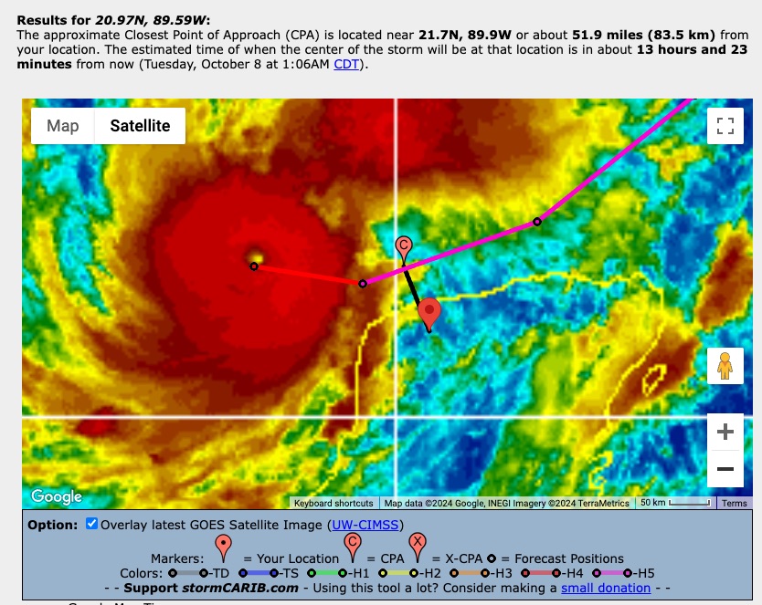
Monday, October 7, 2024 09:39AM PDT - Cat-5
- Milton has just been upgraded to a Category 5 hurricane! Sustained winds are 160 mph! I know 'everyone' is focusing on the future impact on Florida. But it is actually skirting quite close by the Yucatan Peninsula. The center of the storm is expected to pass by Merida later today at about 52 miles! Also, its Closest Point of Approach with Cancun is only 114 miles (in 24 hours). Hopefully it doesn't make a wobble southward. Stay safe over there! -Gert
 |
| - - - Closest Point of Approach Milton with Merida Mexico [10AM CDT Advisory] - - - |
Saturday, October 5, 2024 10:51AM EDT
- Milton
-
Good morning,
Fortunately for the Caribbean, there is not much to report on this very active time of the year. Hurricane "Captain Kirk" is roaming the Atlantic with no threat to land, yet. Once transitioned to extra tropical, he will have an impactful date with France extending into Germany with indirect effects on the UK, Portugal and Spain. That's how he looks now. A wobble to the north or south on the way will be worse for wear for the UK and Portugal.
Hurricane Leslie, having finally escaped the wind shear from Kirks tail, finally became a hurricane this morning at 80 mph with stronger gusts. Like Kirk, Leslie will roam the open Atlantic, unless the ridge that is supposed to carry her to the NW then N does not pick her up. Then we might have an East Coast problem down the road. Again, no threat to the Caribbean.
92L. A system which has been on the watchlist all last week, percolating slowly in the SW Gulf of Mexico. Well, that percolation is coming to fruition and it has the Florida Peninsula in its sights. The trough and high wind shear to the north will prohibit soon to be Milton from going north as he traverses the GOMEX while steering him eastward. That means a date with Florida. Preliminarily, looks to be a landfall somewhere between Ft. Myers and just north of Tampa. Way too early to tell although landfall is probable on Wednesday due to an increase in forward speed. As of this moment, we are looking at a Cat 1-4 depending on RI (Rapid Intensification) which is a possibility although wind shear and dry air intrusion is also possible upon approach to landfall which would weaken the impact somewhat. No guarantee. Again, this is at this moment of writing.
A tropical depression is likely today or tomorrow and even a TS designation is probable by the weekend's end. A NOAA Hurricane Hunter is scheduled to investigate today with subsequent investigations tomorrow with soundings and samplings of the atmosphere surrounding 92L. The bathwaters of the GOMEX were not ruffled by the quickness of Hurricane Helene's traversement on her devastating journey so upwelling did not have time to occur, hence the SST's remain hot and deep..
I expect PTC warnings to be issued at 11 am or at least 5 pm today. This weekend, shop and prepare. Monday, Prep. Tuesday, finish prep. Wednesday storm. The NW Bahamas are also mentioned in the prelim advisories as "Milton", as he exits stage right, will affect those islands as well, weakened but by how much depends on how strong on Fl landfall in the first place and at what forward speed.
I had a bad feeling last week about this mess in the SW GOMEX which is why I chose to stay working in Florida as opposed to going back to STT to work as scheduled. Looks like that will be delayed again but my wife, cats and house come first. Yours should too. Well, maybe you don't have cats but still.... Hope for the best and prepare for the worst. Look out for your neighbors, especially the elderly folks. Your pets should be a priority as well.
More later or tomorrow. Stay safe and prepared!
Dave
Thursday, October 3, 2024 09:33AM PDT - Leslie
- A new day, a new storm it seems. Tropical Storm Leslie formed in the far eastern Atlantic behind Hurricane Kirk. It is sitting pretty low at just 10N, but although it is currently moving west, Leslie is expected to follow Kirk and veer north well before reaching the islands. It might still become a Category 2 hurricane or more. Kirk meanwhile has become a major hurricane, and might even reach Category 4 status. Maybe the islands will get some swell from this storm. But nothing major, I like storms like this. Two more down. There might be something developing in the bathtub known as the Gulf of Mexico, but that will not affect us. Stay safe!
-Gert
Monday, September 30, 2024 06:27AM EDT
- Home grown
-
Good morning,
First prayers and condolences for all who were in the path of Hurricane Helene. I think when all is said and tallied, she will rival Katrina for the amount of destruction she caused not only to whole towns and villages but also the infrastructure. I see her retirement from the hurricane name list as well.
TS Isaac has no worries on retirement this year as he continues to roll around the open Atlantic and should be relegated today or tomorrow morning to a depression then back to his beginnings as an open trough.TD Joyce also should go poof today and is no threat to any land as she heads NNE to the colder Atlantic.
TD 12 looks to become our next hurricane and a major at that by Friday. Soon to be Hurricane Kirk, now traveling mainly west, is expected to take a turn to the WNW in a couple days and keep trucking that way which is great news for the islands and the Caribbean. A couple troughs coming off the east coast should keep him away from the mainland but too early to tell with certainty at this point. Should keep an eye on him though in case he doesn't gain latitude.
The wave that is just behind TD 12 is more of a low rider which will definitely bear watching this week after TD 12 pulls away. The other area to watch is the same area where Hurricane Helene was spawned in the NW Caribbean and GOMEX. She didn't spend much time lingering around and as such, not much upwelling occurred so this one will have plenty of bath water to work with too. This is where some of the home grown ones start their antics come October and November, sometimes with little notice unlike a Cabo Verde system.
So, just as we get rid of 3 we are probably gonna have 2-3 to follow shortly. Let them all stay out to sea please. Better updates to follow as the forecast and the storms themselves progress.
Stay safe and prepared!
Dave.
Saturday, September 28, 2024 10:31AM PDT - Three storms!
- I am back! In spite of the ominous season forecast, not much has happened in my 3+ week of absence! And although there are 3 active storms right now, we in the Caribbean are still doing fine! Thanks to Dave for holding the fort while I was away.
Helene is of course the big story. Another storm that rapidly intensified to a Category 4 storm due to the above average seawater temperatures in the Gulf of Mexico. Added to the devastation was the big storm surge that due to the topography of the Big Bend region of Florida where it made landfall. The curvature of the coastline made it so that the water could basically only go onshore and not escape easily by spreading out along the coast. For more discussions on Helene see Yale's Eye on the Storm blog (Jeff Masters/Bob Henson), Brian McNoldy's blog or Michael Lowry's blog.
The second active storm is Isaac and the only hurricane. It is in the north central Atlantic and moving away (east) of us. It should keep a safe distance from the Azores as well. Joyce is about 1100 miles east of us, and is luckily for us curving north well before it reaches the islands. Joyce is struggling with a lot of vertical wind shear right now and is expected to weaken to a tropical depression in 2.5 days.
A tropical wave that came of the African coast and is now near the Cape Verde islands is the next system for us to watch. Looking at the ECMWF model forecast it looks like this low might become something by next Friday/Saturday, but will veer north well before it reaches the islands. The NHC gives it a 40% chance to develop in the next 7 days.
There is also an area of interest in the Western Caribbean Sea. It is expected to move into the Gulf of Mexico so should not bother us. Formation chances in the next 7 days are only 40%.
That's it! It seems like a lot going on, but for us, not much too worry about. Let's keep it this way. However, I fear that with these above normal sea surface temperatures in the Atlantic that we might get an active tail of the season... Although the 'historical peak' of the season is past us, it is not over yet! -Gert
Thursday, September 26, 2024 08:34AM EDT
- Helene
-
Good morning,
While not a part of the Caribbean, Helene was spawned in the Caribbean courtesy of the CAG (Central American Gyre). This post will be short but not sweet. Helene will be a devastating entity, not just along the coast but well inland. Basically affecting the entire states of Florida and Georgia reaching into the southern Appalachians
The cone you see on TV is just a direct path based on the model projections. Outside this cone, is the real story. Helene is huge. She has about 16 hours before landfall to become a Cat 3, maybe a Cat 4 if rapid intensification continues. Storm surge will be the killer upon landfall. The winds, flooding rainfall, and probable tornadoes will be far reaching upon impact and for hundreds of miles inland. Power outages will be massive. So will the landscape damage inland.
Dry air intrusion from the west has limited Helene's ability, at this moment anyway, to fully realize her potential. However, she has reached the Cat 2 threshold of 100 mph sustained winds per hurricane hunters recon. Storm surge, upon landfall is expected to be 10-20 ft which translates to 1-2 stories building wise.
Bottom line, I see Helene will be farther east landfalling based on satellite and radar imagery which will bring more catastrophic effects to Jacksonville, Tampa, Orlando and even the east coast through Georgia. But weather, being the inexact science it is, makes up it's own mind and could just follow the cone or even go a bit west late.
Finish preparations, be aware constantly, and evacuate if necessary. Long range models show something similar the first week of October as well. Stay safe and prepared!!
Dave.
Saturday, September 21, 2024 09:55AM EDT
- Uncertainty with certainty
-
Good morning,
The subject is a come see, come sah moment. We have several areas of interest in the Atlantic and the NW Caribbean with the Atlantic being the come sah moment and the NW Caribbean, the come see moment.
First, the Atlantic. Invest 96L, located in the middle of the Atlantic Ocean, will possibly become a TD at some point as it travels slowly towards the NW then N, eventually being picked up and carried into Portugal and Spain as a strong extra tropical system. Chances are slim though and a fish storm for the time being.
The remnants of TS Gordon retain the possibility of regeneration while moving at a paltry speed mainly NW over 1,000 miles to the SW of the Azores in the mid Atlantic. Again, chances are slim though while also retaining his designation as a fish storm, with no threat to land masses.
A low rider tropical wave will be something to watch in the coming days as it exits the African coast. Lingering Saharan Dust lurks to its north so as it climbs slowly to the WNW, development, while probable, will be slow.
Now, the come see moment. The NW Caribbean in the area of Belize and the Yucatan Peninsula is experiencing a CAG event (Central American Gyre), basically a large area of broad low pressure usually found in early season and then Oct and Nov. This event creates a large rain and breezy event along the Central American coast. It also spawns and spins off potential tropical systems as well. The NHC is anticipating a spin off this coming week into the Gulf of Mexico where land interaction is inevitable as the only escape route would be through the Straits of Florida, probability, if a system formed, is less than 1%.
Current major models are in disagreement on timing but fairly in agreement on land impact, again as of this moment. What development and status it reaches is anyone's guess not to mention, where it will impact the gulf coast. Wind shear is negligible while SST's (sea surface temperatures) are extremely conducive in the Gulf. A dipping, steering jet stream combined with high pressure drifting eastward looks to pull whatever develops N then NE with an early looking landfall in the current year's storm magnet, the Big Bend of Florida. The weaker the storm development, the possible land interaction will be farther west. The stronger and quicker development, the farther east it will be pulled.
All along the gulf coast from Texas to Florida should be paying attention to this potential September storm, probably named Helene unless one of the Atlantic systems get their act together quicker. "I" storms are the most retired names in hurricane history. The next "I" is Isaac. We do not need another "I" retirement. The NHC has been focused on this possibility in the Gulf for several days now so it is not something to dismiss. Tampa, your shield might need to be raised if a more easterly than NE track manifests itself. Just saying.
Stay safe, prepared and not scared.
Dave.
Saturday, September 14, 2024 06:43AM EDT
- "Poof" for now
-
Good morning,
Hurricane Francine's remnants continue to drench the Mississippi and Tennessee river valleys while dissipating with winds right now about 15 mph and dropping. Flooding is the main concern.
92L and 94L have "poofed" despite their initial evil intentions as a steady diet of waning Saharan Dust, unusually stable atmospheric air, and wind shear to the east of the islands contributed mightily to their demise before they could cause any trouble. For now, scattered showers are about all that's left of either. It is possible, after passing north of the Lesser Antilles, 94L could regenerate and become a threat to the Bahamas and SE coast by next weekend. I did share, possibly.
The only organized game in town is weak TS Gordon, located about 1445 miles to the ENE of the outer Caribbean Island of Anguilla. At approx. 20.1N 50.0W, moving a slow 9mph, the poorly defined center so far, is being sheared as evidenced by the center being out front of the actual convection. Forecast to shift from WNW to W to WSW in the next 48 hours, Gordon will likely be downgraded to a TD due to the shear, stable air and a healthier diet of dust. In fact, it could even return to just a tropical low thus losing all status.
By Wednesday into Thursday, a turn back to the W then NW and eventually the N is anticipated, back as a TS. That kinda depends on the factor of strength. A stronger system is more likely to make that turn. A weaker system is more likely to remain on a westerly course. I'd prefer a stronger, turning north system as a dipping down to the WSW brings a reminder of a certain 2017 hurricane which did the same thing. Irma.
The MDR (Main Development Region) closer to the eastern African coast shows a few lower waves plus a few lower ones on the African Sahara.marching towards their turn to drop into the ocean. These ones will bear watching down the road. Wind shear is expected to relax and our, so far, omnipresent protectors Saharan Dust and unusually stable air, are expected to gradually fade, opening the last 42% of the official hurricane season for business.
Lastly, my friends in the Carolinas could be looking at a possible TD or even minimal TS mid week due to a system off the coast. Nothing certain here development wise but it's going to not be a beach weekend their for sure with rain and blustery winds regardless courtesy of a tight pressure gradient.
Stay safe and prepared. Happy Saturday.
Dave
Sunday, September 8, 2024 09:43AM EDT
- Never better than later
-
Good morning,
The tropical Atlantic and Gulf of Mexico have been in an unusual slumber since Ernesto back in August however they now have decided to wake up unfortunately and, as the saying goes better late than never, in this case should be reversed saying never better than late. Noted Tuesday is the historical peak of hurricane season with totally untapped atmospheric moisture to work with ahead of them all.
However wishful thinking that could be, reality has started up again in the tropics and GOMEX. Today is the anniversary of the Great Galveston Hurricane which killed over 8,000 people as a Cat 4 in 1900. It was and still is the deadliest natural disaster in US recorded history. Ok let's get down to what's going on now.
92L: A wandering system in the mid Atlantic, at approx. 13N 43W with no real steering currents, it is expected to start moving Monday at some point mostly W then WNW at approx. 10-15 mph. The possibilities of this one reaching Cat 1 or Cat 2 status are good down the road but steering currents, at the moment, look to take this OTS (out to sea) as a fish storm but here in the islands we need to be vigilant and prepared as things always change after 4-5 days and this is no ordinary season.
93L (probable): Another meandering wave to the SW of the Cabo Verde Islands is forecast to be absorbed by another wave exiting the African coast on Monday. This also has a good chance to develop later in the coming week. It also is forecast, again, as of this moment, to become a fish storm. And again, time and Mother Nature will tell.
91L: Drenching parts of the Mexican Gulf of Mexico coast and the Yucatan, is likely headed for a date as a strong tropical storm with Texas and Louisiana, already saturated by recent tropical moisture. Looking to start NW, then N to NNE, landfall is expected Thursday or Friday. Hurricane Hunters are expected to start investigating today. Wind shear and drier air to the north might keep this from ramping up but I suspect the models are underestimating this system with a hurricane quite possible with the bath water it has to work with.
Stay safe and prepared!
Dave
Sunday, September 1, 2024 14:05PM EDT
- Starting up again but....
-
Good afternoon,
Not much has been active in the last few weeks in the tropical Atlantic even though the forecast has been quite active, due to more northerly waves coming off the coast of Africa running into and interacting with our early season protector, the Saharan Dust Layer. The few low wave runners that did emerge and avoided interaction with the dust have been the troublemakers so far this season and they have been quite destructive with long longevity. Fortunately there have only been a few. Now, the dust is receding in density and strength giving the waves the advantage.
The closest wave to the Cabo Verde Islands has a decent chance of formation but is likely to become our first "Fish" storm of the year if it materializes. All others so far have been land fallers. The system ahead of it and closest to the Leeward and Windward Islands is struggling but if it can hold itself together for a few days, it could intensify after interaction with the island chain once entering the Eastern Caribbean. Normally, a dead zone for most tropical system development, if it does manifest itself, it has several ways to go. Directly to Belize and Mexico is one path. The other is south of Puerto Rico and across the DR. Those are just 2 options and none are cut in stone. Strength and direction are determined by the Bermuda High steering wheel, humidity levels, and wind shear elements. Either way, gusty winds, high surf, and heavy rains are to be expected. Hurricane Hunters are expected to investigate so we should know more details tomorrow.
Also a wandering system is off the Texas/Louisiana coast sending flooding rains with rough sea conditions before moving inland Tuesday. Might reach TD status before but the conditions will remain the same. The GOMEX should be on the alert the next few months with Florida in particular and our Lesser Antilles.
Stay safe and prepared.
Dave
Friday, August 16, 2024 15:47PM PDT - Bermuda
- Sorry, I was out camping for a few days without much internet. First thing I see is that Ernesto is now a Category 2 storm, but luckily weakening to a Category 1. Next thing, using the Closest Point of Approach-tool is that it is going straight for Bermuda, and that the outer bands are actually over the island already! I will try to get some reports from Bermuda. I am happy it didn't become a surprise "rapid intensification" storm. With these warm sea surface temperatures you never know. I have lived on Bermuda for a little bit, and I know that there houses are well built. This will not be a disastrous event for them, but there will still be damage of course since it is a hurricane! So don't underestimate it. Stay safe everybody! Don't do stupid things. -Gert
Wednesday, August 14, 2024 08:59AM EDT
- Soon Hurricane Ernesto
-
Good morning,
Reports coming in, so far, reveal minimal damage wind wise, flooding is occurring in Puerto Rico and the Virgin Islands, but no fatalities which is the best part. Material things can be replaced. You cannot. It will take some time for Ernesto to pull away from PR and the VI as that tail, a hallmark of these storms, has yet to deliver the final lashing. Power is still out in the VI, as usual, while PR has hundreds of thousands out of power with severe flooding.
Still a 70mph tropical storm, Ernesto is approx 135 miles to the NW of San Juan, PR traveling NW at 16 mph, a shadow of the racer earlier when he was honking along at 28mph. That fact of traveling 22-28 mph across the Atlantic plus a continual intrusion of dry air into his core contributed mightily to Ernesto not attaining hurricane status before entering the islands which is a very good thing.
Right now, showing a shrimp like appearance while flushing out the dry air from his core, Ernesto is probably a hurricane already, especially since as of the 8am advisory, his central pressure has dropped to 991 millibars. Hurricane Hunters will be investigating this morning to confirm Ernesto's status.
Down the road on a probable date with the west side of Bermuda, which leaves the island on the stronger east side of the storm, preparations are already underway for Ernesto then maybe interaction with the Canadian Maritimes with the UK in play afterwards. Before all this transpires though, Ernesto will create large waves, deadly rip currents and coastal flooding on his way to Bermuda all along the East Coast. The low lying islands of the Turks and Caicos plus the Bahamas will definitely flood to an extent from these increased waves crashing in, with the eastern and northern most receiving the brunt.
Stay safe and prepared. More waves are on their way!
Dave
Monday, August 12, 2024 18:17PM EDT
- TS Ernesto
-
Good afternoon all,
TS Ernesto has now been declared following a days long investigation by the hurricane hunters and NOAA aircraft at the 5pm advisory. He was able to finally wall off the western side of the center of circulation resulting in the upgrade. Still ragged in nature with a broad circulation at that, now that a center has been defined, Ernesto will begin consolidating and slowly strengthening. This bodes for a stronger Tropical storm to affect the islands than previously forecast due to more favorable conditions, if it gets its act together. Tropical storm warnings are up from Guadeloupe and Monserrat to PR.
Located approx. 280 miles to the SE of Antigua, Ernesto is traveling at a brisk WNW 28 mph, another inhibitor of anything but slow strengthening. That being said, forward speed is expected to slow upon approach to the islands. Slower forward speed, humidity levels of the atmosphere on the rise creating a much moister environment, dust levels well reduced and low wind shear all favor Ernesto's rise in intensity.
Current model projections show a 60 mph tropical storm around the Virgin Islands and Puerto Rico with higher gusts. 4-6 inches with isolated higher amounts anticipated with the slowdown in forward speed. This includes all the VI and BVI. Puerto Rico, depending on the track, could get up to 10 inches depending on the track and speed.
Currently, extrapolating out using current speed and direction of WNW, Ernesto's COC or center of circulation (It is not a hurricane hence it does not have an eye) will pass Antigua approx 40 miles to the north, at 45-50 mph around 11 am tomorrow. St. Croix you will have Ernesto's COC pass by 15 miles to the north, at 50-60 mph approx midnight Tuesday while the VI and BVI will experience the core visit approx 12 miles to the ENE at around 2:30 am Wednesday at 60-70 mph, all with higher gusts.These numbers are sure to change as this is based upon forward speed and track right now.
Forecast to become a Cat 2 hurricane down the road and make a right turn clyde headed for Bermuda and the Canadian Maritimes of Nova Scotia and Newfoundland, Ernesto could still miss that trough and head towards the US east coast but that scenario is becoming increasingly unlikely.
Stay safe and prepared!
Dave.
Sunday, August 11, 2024 10:08AM EDT
- Soon Ernesto
-
Good morning and Happy Sunday,
After a brief respite, the tropics are starting to heat up as if on cue with several impressive waves making their way across the MDR of the Atlantic and the Saharan area of Africa. As Gert shared, our possible next system will not be a Beryl by any means in our area, but could have evil intentions down the road.
Invest 98L. Located approx.12N, 46W while traveling W to WNW at a relatively brisk 17-22mph, our soon to be in a few days tropical depression is still trying to fight off the SAL (Saharan Dust Layer), our biggest protector for about half of every official season. Its broad circulation plus interaction with the SAL will prevent any rapid consolidation so a TD is in the cards shortly, possibly by Tuesday. So this means btw 48-60 hours from now, this system will arrive probably in the Leeward Islands/Northern Lesser Antilles. There are a few models that take it more westward and southerly, going through the islands and interacting with the DR and Haiti. This is still an uncertain forecast at the moment but most concur on the former track.
For the Lesser Antilles, 98L's brisk forward speed will also slow intensification while the diminishing effects of the SAL, low and favorable wind shear, and very warm SST's (Sea Surface Temperatures) will favor intensification into a probable medium to strong TS entering the Lesser Antilles. Beyond that, soon to be Ernesto will morph into a hurricane northwest of the Lesser Antilles with several track scenarios in play. Recurve straight out to sea and menace shipping lanes and the fish. Avoid being picked up by a trough and run over the Turks and Caicos, the Bahamas and into Florida (Unlikely but possible). Get close to Florida and then picked up by the trough and carried up the coast a short bit then give Bermuda an unwelcome visit.
It all depends on the strength of the Bermuda High and the arrival timing of the trough coming off the US. Regardless this is down the road and many things can and will change as they usually do. This means everyone in the potential path should be prepared for the worst and hope for the best. Yes a cliche phrase but very important nonetheless.
I expect PTC5 to be issued within the next 24 hours in order for preliminary watches and warnings to be issued. Marinas in the expected areas of the Lesser Antilles including the US and British Virgin Islands, Puerto Rico, Antigua, Anguilla, St. Maarten/St. Martin south to the butterfly island of Guadeloupe are emptying already. Preparations should have been done already for storm season and if not, now's the time.
Behind 98L, the wave train is active. While every wave has the potential to develop, many will not. However, those that do will test your complacency, your patience, your preparedness, your character, and your mental health. I know, I've been there from Marilyn through Irma/Maria.
Will update tomorrow. Stay safe, prepared and enjoy your Sunday!
Dave
Friday, August 9, 2024 14:30PM PDT - Ernesto?
- While a week later and slow moving Debby is still dumping rain in the US, there is some potential development in the Atlantic. A wave that came off the coast of Africa Wednesday has a chance of 60% to become something in the next week. It is still a long way away, it is expected to reach the islands Tuesday. Currently dry Saharan air is preventing development, but by early next week things look more 'positive'. Models indicate that it might be a tropical depression or tropical storm when it reaches the islands. The GEFS model is leaning towards strong tropical storm and the European model to a depression. However, I would not rule out a stronger storm since the waters are plenty warm. No need to panic yet, it won't be a Beryl, but we have to keep a close eye on it, esp. when it moves further west on the island chain. Stay safe! -Gert
 |
| - - - GEFS 1 week model forecast [Weathernerds] (click on image for full size)- - - |
Saturday, August 3, 2024 12:17PM EDT
- Debby soon
-
Good morning,
Traveling back to Florida yesterday for Debby. Not a pretty trip but made it. Soon to be TS Debby, the 4th named storm of the season will be crossing the western end of Cuba shortly and entering the GOMEX where her bath water awaits at approx 88 degrees, fuel for intensification. Problem for her and a blessing for Florida is her broad circulation should not allow quick intensification much less rapid intensification until 1/2 way up the Florida coast. The forecast after that calls for quicker intensification and landfall anywhere from the Big Bend to the hurricane magnet in that area known as Cedar Key.
The longer over her bath water, the stronger she will become and a start of rapid intensification, in my opinion, is possible upon approach to landfall. Fortunately. that landfall will be close at hand therefore limiting the amount of that intensification. Had this system been wound up tight already, another Cat 4-5 would be on approach tomorrow into Monday. Nonetheless, most of Florida will receive copious amounts of rainfall. The Governor has declared a state of emergency for 54 out of 67 counties already allowing resources to get in place and ready. Flooding potential and surge are the main concerns. Right now, to me, a Cat 1 or potential Cat 2 is realistic assuming she stays in her bathtub. That means the usual suspects as in loss of power, flooding, storm surge, and downed trees/foliage. Farther to the south along Florida's west coast, heavy rains and storm surge will be the main threat while the rest of the peninsula receives gusty winds and drenching rainfall.
Silver lining although many won't be thinking this way is that the drought for western Florida should be over after Debby's passing. Small comfort but something positive.
After crossing the peninsula, the east coast from Ga to NC will be in deep trouble if she stalls according to the computer ensembles which are in agreement. When and if the steering currents collapse and Debby is allowed to wander for 3-6 days off the coast, historic flooding will be probable and dangerous. I believe at this point she will stall and then, instead of going on her merry way into the Atlantic, she will dive into the Carolinas, continuing a path of calamitous shenanigans and destructive flooding. No one likes to be wrong but I hope I am here.
I'm going to get my generator and rest of the place ready for the next few days. Stay safe and prepared!
Dave
Tuesday, July 30, 2024 21:09PM EDT
- Still complicated
-
Good evening,
The tropical wave, broad in nature while still trying to fight off the omnipresent Saharan Dust, is making its way towards the Northern Antilles, moving WNW at approx.10-15 mph. Its effects should start to be felt starting tomorrow night in some areas of the Lesser Antilles moving into Wednesday and Thursday. While pretty much void of T-storm activity, convective spots have started to blossom ever so slightly on satellite imagery. No organization is expected due to its continuing liaison with the SAL as it moves through the initial island chain while scattered T-storms, rough seas, high surf on mainly northern facing coasts, and gusty winds will be on the menu at least through Thursday evening. Lingering effects will travel into Friday.
While the fight continues with the dust basically ahead of it based on satellite imagery, its steady advancement plus persistence will start to pay off near Haiti, stretching even to Jamaica, The Turks and Caicos, Cuba, the Bahamas, and parts of the Florida Peninsula eventually. Why?
The dust will finally be filtered out which has been the island's protector so far or this could have been a dangerous hurricane on approach. Moisture will return to the system allowing it to flourish, wind shear will be low to intermediate and SST's are around 87 degrees around the Bahamas/Florida. All ripe conditions. However, there are a couple of mitigating factors. The first is the mountainous terrain of PR, the DR, and Haiti. Any interaction with those mountains will surely be disruptive to a struggling system. The second is how broad in nature it is. This wave will definitely need some time, even over open water to consolidate.
Complicated. The forecast strength and track. Most ensembles have it curving no matter what its designation is, TD, TS, to the north and having a collision with the Carolinas. Then there are some which take a southerly route through the Florida Straits into the GOMEX where all bets are off at the moment. Once loose in the Gulf, it has to go somewhere for a landfall. A stronger organized system will normally move northerly while a weaker system will move more south to west. Remotely, RI (rapid intensification) is a possibility if it can get organized quickly before the Turks and Caicos. I did say remotely not impossible. So, many variables to contend with a wave not even looking like a threat yet.
Hurricane Hunters are currently scheduled to investigate on Thursday so hopefully more up close and personal detail from them will reveal this wave's true intentions.
Stay safe and prepared.
Dave.
Sunday, July 28, 2024 07:35AM EDT
- Complex
-
Good morning,
After a quiet period with the reign of Saharan Dust which has eradicated any tropical development since Hurricane Beryl, the MDR is slowly heating up. While the dust is still a mitigating factor, its influence will be diminishing slowly as well.
At the moment, what happens down the road over 7-10 days is quite complex so this will be a short post with so many options for development and track making a good forecast nearly impossible. Even the models do not agree.
In the mid Atlantic around 45W, a tropical wave is chugging along around the Bermuda high up to the north which is its steering current. That steering is forecast to curve this wave towards the Leeward Islands and Lesser Antilles by Tuesday night into Wednesday possibly making depression status right before or over the northern islands but still could be just a strong tropical wave. Either scenario brings gusty winds, heavy rains which are needed but not all at once, rough seas and coastal erosion. Then strengthening as it gets to the north of Hispaniola where the Turks and Caicos would be up first onward to the Bahamas where things could get very interesting.
Several of the other models have it more to the left if the high strengthens and goes into the Caribbean headed for Cuba. I'm not buying this scenario quite yet after looking at the steering map.
The vigorous waves have been rolling off the African coast several days apart and are lining up looks like activity is about to resume. While looking ominous on land, after splashdown, they have fizzled but don't look for that to continue for long. If you haven't prepared yet, it's time. Complacency kills. You can replace materials. You can't replace you or your family.
Stay safe and prepared. Happy Sunday!
Dave.
Saturday, July 6, 2024 07:26AM EDT
- Defiant and deadly Beryl
-
Good morning,
Former briefly Category 5 Hurricane Beryl, the earliest Cat 5 recorded in the Atlantic and only the second in the month of July (Hurricane Emily 2005), also now holds the record for the first Cat 4 hurricane to form in the month of June. Now though, the end is near for Beryl's destructive and deadly reign as she chugs to an uncertain intensity ending somewhere along the central coast of Texas. Having continually exceeded expectations, especially in the face of over 20kt wind shear and dry air intrusion facilitated by said wind shear, nothing can be taken for granted in the next few days before expected landfall.
Only the Yucatan Peninsula has been able to knock Beryl down but not out. Now over open very warm rich fuel waters in the Gulf of Mexico as a discombobulated, almost indiscernible 60 mph TS, Beryl is also not barrelling along at over 20 mph like she has most of her life since June 28th, now down, for her, to a paltry 12 mph. This part is not good news as she will have more time to reorganize into a probable Cat 1, maybe Cat 2 before landfall. That landfall is expected to be close to Houston which is a worst case landfall scenario due to the Houston area's population, potential for flooding, but also the number of oil platforms, refineries, and chemical storage facilities staged there. In addition, the major dam which supplies most of the water for the Houston area was recently diagnosed with 2 critical deficiencies and a significant rain/flooding event has the potential to create a failure of that dam with devastating consequences.
Beryl is expected to regain hurricane status Sunday as she needs today to pull herself back together as her inner core has been exposed with the wind shear, dry air introduction and land interaction combination. The farther north she travels, the less dry air and lowered wind shear will be evident. It's a good possibility Beryl will be attempting another rapid intensification phase upon approach to landfall.
Elsewhere, the Caribbean and Atlantic are quiet with the exception of former 96L attempting to give Jamaica a second dose of tropical mischief albeit as a large tropical wave over the next day or so. Fortunately, this gives the Windward Islands a chance to focus on recovery efforts from Beryl's earlier rampage. Don't let the quietness give you a complacent feeling. This is only the 36th day of the official season and November 30th looms way off in the distance. For now that light at the end of the tunnel is but a pinhole.
Stay safe and prepared!
Dave
Thursday, July 4, 2024 12:43PM PDT - Where to donate
- Beryl is moving away from the Cayman Islands, after the eye of the storm skirted the south coast of Jamaica. The eye came closer to Grand Cayman than I wrote yesterday, I calculated that the closest point of approach was just 46 miles (relative to Owen Roberts Airport). Hope we hear soon more from the special local hurricane correspondents with how they fared.
The hurricane is expected to make landfall in the Yucatan Peninsula tomorrow AM, very close to Tulum. Lucky for them it should have weakened to a Category 2 hurricane, but don't be surprised it is still a major hurricane. With these high sea surface temperatures you never know, although on satellite images Beryl doesn't look that good anymore! The eye is also not that symmetric anymore, a sign of weakening. But the north side of the storm ("Tulum" side) is still plenty strong...
Finally, I created a new webpage listing Relief Efforts and Where to Donate. If you know of any good relief organizations, esp. local ones, let me know and I will list them. -Gert
Wednesday, July 3, 2024 09:06AM PDT - Jamaica, brace yourself!
- Just a short update, Dave made a great posting late last night, taking time out of his busy schedule. Beryl is now affecting Jamaica. Tropical storm conditions are already felt, with hurricane conditions to follow. I was hoping that the hurricane would weaken to a borderline Category 4, or even Category 3, but it is still a with 145 mph sustained winds. Just 15 mph in windspeed does make a difference, see the little 'Wind force' section on the right.
Although Beryl will go a bit more south of the Cayman's, it is also stronger than expected. It will unfortunately still be a Category 4 storm when the center travels about 65 miles south of the island tomorrow morning. That is well within reach of 50 kt (58 mph) winds, but out of reach of hurricane force (64 kn, 74 mph) winds, sustained that is, not gusts, which can be 20% higher! And don't forget about the storm surge, which will be a factor for low lying Cayman. So not out of the woods.
After Cayman, it is the Yucatan Peninsula. Right now the center is expected to make landfall about 70 miles south of Cozumel Friday morning (see the closest point of approach calculator.
I am still trying to gather more reports from Grenada and St.Vincent and Grenadines from my local hurricane correspondents. Stays safe everybody, don't do stupid things. -Gert
PS. People know I do hate to ask for donations, but they are really needed to keep this website going. You can donate here.
Tuesday, July 2, 2024 22:27PM EDT
- Barreling Beryl
-
Good evening,
Cat 4 Hurricane Beryl is still steaming through the Caribbean like someone stole the armored truck money at 22 mph according to the latest update by the NHC. Interesting how a system traveling this fast can hold its own but when you're well formed and shutting out all outside influences, except increasing wind shear, you just keep trucking and that is what Beryl is doing.
Sadly causing deaths and severe destruction in Grenada and St. Vincent and the Grenadines, the only silver lining was it was moving quickly. A mere 30 minutes via a direct hit on the island of Carricaou along with Union Island, the southernmost island of the Grenadines 10 miles to the north resulted in a complete flattening, akin to Hurricane Irma turning Barbuda into a large sand spit in 2017.
While an eyewall replacement cycle, shared in my previous post did occur, it was early and over very quickly allowing Beryl to regain steam and then some before impact. Now, after passing through her destructive and deadly course through the Windwards as a Cat 4, she did briefly reaching 165 mph sustained Cat 5 winds with up to 200 mph gusts, Now down to 150 mph which really doesn't make a bunch of difference, she is on her way for a date with Jamaica and the Cayman Islands. First Jamaica tomorrow night and the Caymans the next. The Dominican Republic is receiving heavy rainfall and Haiti will as well as Beryl continues on a slow NW climbing in latitude trek for now.
A close brush or direct hit on the southern coast of Jamaica is forecast as a Cat 3. Many residents along Kingstons coast and harbor are fairly complacent according to news reports plus many business owners will not leave for fear of looting afterwards. I understand but your life is not worth staying where the wind and storm surge will inundate you tomorrow night.
Down the road, the Caymans are expected to be spared the eye and brunt but passing just 70 miles south will pose serious issues surge wise and even wind wise. The hurricane magnet this year, so far, courtesy of strong high pressure to the north everywhere, is the Yucatan Peninsula. A Cat 1 or maybe Cat 2 strike is logical. Following Beryl's trip across the peninsula, emerging into the Bay of Campeche, a northern Mexico or SW Texas landfall is in the making, at least for now as a strong TS or Cat 1.
96L is no longer a threat to develop according to the NHC basically staying a strong tropical wave in Beryl's wake. In the meantime, more waves are lined up.
Stay safe and prepared!
Dave
Tuesday, July 2, 2024 08:09AM PDT - Category 5 Hurricane Beryl
- Beryl is speeding at 22 mph west northwest through the Caribbean Sea towards it next target... Instead of weakening after it crossed the islands, it actually became even stronger. Beryl is now a category 5 hurricane, packing 160 mph sustained winds. A bit earlier in the day it peaked at 165 mph. Hopefully the weakening trend continues, but can it be a bit faster please. It will say again what many others have said, 'unprecedented'.
The forecasted track is trending a bit northward, while earlier it looked that the storm would stay at least 50 miles south of Jamaica, now it looks a lot closer. The current closest point of approach with Kingston, Jamaica is only 18 miles in 30 hours..., basically a direct hit. Beryl's path looks very similar to Ivan back in 2004 as Krishna pointed out on the Jamaica page. However, Ivan passed Jamaica as a Category 5 hurricane, Beryl should be weaker, a Category 4, still a major hurricane... But keep in mind that Jamaica will be experiencing the strong northern side of the hurricane.
It is also getting too close for comfort to the Cayman Islands. The closest point of approach to Grand Cayman is only 40 miles in 45 hours. At that time though it is expected that the hurricane has further weakened to 'just' a Category 3.
I don't have to tell you all that preparation is key. Don't think you are safe, since hurricanes are unpredictable. Just a slight wobble to the north and it is a whole different picture. I didn't even mention Hispaniola, although the center of the storm will pass about 140 miles south of it, its torrential rain will definitely have a big effect. We know from the past that Haiti doesn't deal well with a lot of rain, and water, not wind, is the biggest killer with hurricanes... Stay safe everybody. Don't do stupid things! -Gert
Monday, July 1, 2024 10:10AM PDT - Carriacou
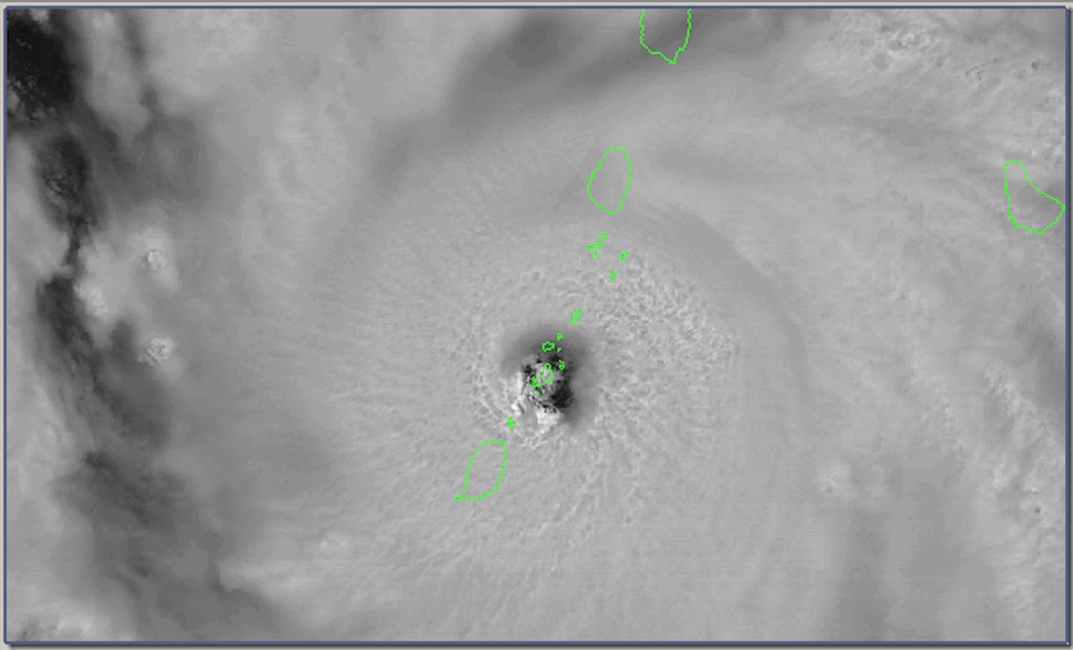
- Beryl is moving through the islands right now. The 11AM NHC Update said: ...EXTREMELY DANGEROUS CATEGORY 4 BERYL MAKES LANDFALL ON CARRIACOU ISLAND... and ...AIR FORCE RECONNAISSANCE AIRCRAFT FINDS BERYL STRONGER... Not good. Maximum sustained winds are 150 mph, a strong Category 4 hurricane. At least it is moving fast and it will be over soon. At this time the center has moved to the west of Carriacou already. Hope to hear some news from them soon. But with power out, it might be a while. "The cone of silence". A scary time for many. I do know someone on Carriacou and see if I can get some info. Also hope to hear from Grenada as well. The northern part should be hard hit, as well as the Grenadines Islands to the north. See the impressive loop on Brian McNoldy's blog, of which I captured a frame below, when Carriacou was in the eye. -Gert
PS1: Before people start freaking out that another hurricane is underway: yes, there is an area of interest out in the Atlantic, and yes, it is taking a similar, but more northernly track, but NO, as of now it is not expected to be a hurricane by the time it reaches the islands.
PS2: Remember, this website is made possible through donations from you.
Sunday, June 30, 2024 18:42PM EDT
- Dangerous Bad Beryl
-
Good evening,
They say many animals and people for that matter who are pretty and beautiful to look at are dangerous in some manner. Many occupants of the sea are a perfect example. Usually, the better and more colorful looking they are, the more dangerous they are. This goes for hurricanes as well. Hurricane Beryl is a dangerous and potentially life threatening Cat 4 hurricane having ramped up from a TD to a hurricane in the space of 24 hours. This is June. Not September. However, conditions have been ripe for the picking with these September like conditions in June, now July and dangerously satellite beautiful Beryl has taken full advantage of them. Chances at reaching Cat 5 status have leveled off, possibly due to a rise in wind shear. Really doesn't matter much as a high end Cat 4 will not be much different from a minimal Cat 5 only classification wise.
About 230 miles SE of Barbados and having slowed forward speed a few mph to 18, Beryl is still making a beeline for the southern Windward Islands. Numerous watches and warnings from Dominica to Tobago have been issued but the same 4 larger islands are still in the bullseye with a wobble here or there. The northern coast of Venezuela and the ABC Islands will also feel indirect effects with coastal erosion, rain squalls, rip currents, and high surf. Storm surge and heavy rain will be prominent for all but the winds will do catastrophic damage within 50-75 miles of the eye since she has expanded her eye and windfield although still a compact storm. The southern coasts of the Dominican Republic and Haiti also have been issued tropical storm watches as Beryl has climbed slowly from a due west trek to a slightly NW path. Jamaica, the Cayman Islands, the western end of Cuba and the Isle of Youth all will be under the gun later this week with a possibility of a Texas strike if the ridge weakens in time. If not, Belize and the Yucatan Peninsula (the storm magnet this year so far) will be under the gun again.
With not much in her way, the islands can only hope for an eyewall replacement cycle to commence close to impact thereby slightly reducing the effects upon landfall. This will not change much but every sliver of hope is worthy of storm appreciation.
I will chat about 96L and its chances in the Caribbean tomorrow. I will say this system is expected to trek more northerly than Beryl at the moment. One good thing is Beryl's upwelling of colder waters should hamper this systems development.
94L, over in the Bay of Campeche, is now a depression and might make a very brief appearance as a TS before plowing into Mexico drenching an already saturated area from the previous 2 systems. Flooding and landslides are expected, again.
Prayers to our fellow southern islanders and hope they have prepared as best as they can. The boaties, hopefully, are not riding this one out or they might be found floating or maybe not be found at all. Beryl is going to be a very bad girl.
Stay safe and prepared!!
Dave.
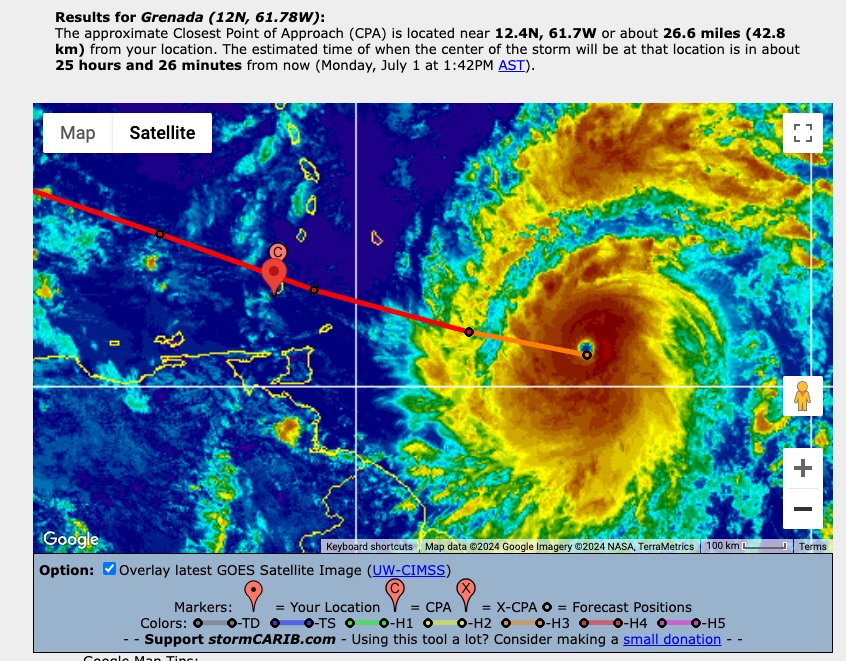
Sunday, June 30, 2024 09:19AM PDT - Category 4
- Not surprisingly with the warm ocean waters, Beryl exceeded expectations and is now a Category 4 hurricane! Not good. It is still moving fast westward, albeit a bit more south of the earlier forecasted track. This means that Beryl is an extremely dangerous storm barreling towards Barbados, Grenada and St.Vincent and Grenadines. Since it is a bit further south, it looks better for Barbados, but worse for Grenada. The northern part of the storm is a bit stronger than the southern part, so no-one is out of the woods yet. See below the closest point of approach of Beryl with Grenada, just 27 miles/43 km to the north, that is relative to the airport on the southern part of the islands. So it will be closer than you think. And that is the eye of the storm, as you can see on the image, a hurricane is not a point! Stay safe everybody! Don't do stupid things. -Gert
Saturday, June 29, 2024 15:38PM PDT - Beryl
- Last night tropical depression 2 was upgraded to tropical storm Beryl, and it is now already a hurricane! It is quite unusual to see a hurricane east of the islands this time of the year because the ocean normally hasn't warmed up too much. But this year it is different with the record high sea surface temperatures. According to Brian McNoldy this is indeed the furthest east a hurricane has ever formed for the time of the year (read more on how unusual it is on his blog...
Fast moving Beryl is expected to strengthen to a major hurricane before it even reaches the islands! Right now it is forecasted to track just 50 miles south of Barbados early Monday as a Category 3 storm. Then tracking over St.Vincent and the Grenadines, just north of Grenada. Check how far the eye of the storm can be from your island, use the closest point of approach-tool on this website. Since the storm is wobbling a bit be prepared for deviations of the forecasted track. Also, don't focus too much on the exact path. A Category 3 major hurricane is not a point, its effects are felt well north or south of the track! So, not surprisingly hurricane watches and warnings have been posted already. See the advisories for more info.
I just want to reiterate the key messages from the 5PM advisories:
1. Beryl is expected to be a dangerous major hurricane when it
reaches the Windward Islands late Sunday night or Monday,
bringing destructive hurricane-force winds and life-threatening
storm surge. Hurricane Watch and Warnings are in effect for much
of the Windward Islands.
2. Heavy rainfall and localized flooding is expected across the
Windward Islands Sunday night and Monday.
3. Interests in the central and western Caribbean should monitor the
progress of this system. Users are reminded that there is large
uncertainty at days 4 and 5 and to not focus on the specific
details of the track or intensity forecast.
Even though it is still 'just' June, take this storm seriously! Esp. since models are in close agreement. If you are in the cone of uncertainty you have to take your precautions now! Good luck everybody, and stay safe!
See also Dave's post just below this one. We did post at the same time. His focus always differs a bit from mine, so please read his post as well... -Gert
Saturday, June 29, 2024 18:38PM EDT
- Beryl and beyond
-
Good evening everyone,
From a benign start to a now projected major hurricane after crossing the MDR in June no less, is a sobering thought for the rest of the season and a dangerous situation upcoming for Barbados, St. Lucia, St. vincent and the Grenadines, and even Grenada.
Located approx 10.2N 49.7W, about 700 miles ESE of Barbados, moving at a good clip of 22mph,and moving due west with a few wobbles here and there, now Hurricane Beryl is traversing untapped record warm SST's while taking advantage of wind shear actually behind it for the time being, a dire lack of protective Saharan dust and nothing in her projected path at this moment to deter her from rapidly intensifying into a Cat 3 with remoteness to a Cat 4 possibility. When I share get prepared early, this is a scenario, albeit very rare, when you should have. History does repeat itself. In June 1933, the farthest east hurricane to form in the MDR struck Trinidad/Tobago and caused immense damage, 91 years ago. While Trinidad/Tobago will be on the weakest south side of this storm, it will still have coastal effects. A wobble to the south deviating from it's projected path will affect Grenada and Trinidad even more so vigilance is of the utmost.
A hurricane warning is in effect for Barbados while the westerly islands of St. Lucia, St. Vincent and the Grenadines, and Grenada are under hurricane watches which will be upgraded shortly. Extrapolating the track using the tools here, if it stays the course the next day or so, the closest point of approach to Barbados is approx 55 miles, St. Lucia is approx 70 miles, Grenada approx 62 miles and St. Vincent and the Grenadines a very dangerous approx 24 miles. Beryl is supposed to remain a small, compact hurricane as shared in my previous post but devastating nonetheless with the islands so close together. Hopefully, Beryl misses all these wickets altogether.
Down the road, after passing through the islands, Beryl will set her sights on Jamaica and the Cayman Islands first with less direct impacts expected in the DR and Haiti although flooding rains will be a good probability. Jamaica and the Cayman Islands look to take the brunt of a weaker Beryl due to the wind shear shifting from behind to the forefront from the west even though the SST's are basically a hot tub waiting to wade in for a hurricane. After those interactions, it depends on any weakness developing which would turn Beryl more to the NW and North putting the western GOMEX into play. Time will tell as it's too early for that.
94L, currently over the Yucatan peninsula, still has a shot at depression status over well traveled waters already in the Bay of Campeche but will be short lived at best before plowing into Mexico and portions of Central America with torrential rains over an already saturated area.
Behind Beryl is another lowrider with early evil intentions but for now, all eyes are on Beryl and rightly so. The islands under watches get your preparations done and done quickly. Beryl isn't playing. Barbados, which doesn't see many like this at all, get ready for hopefully a brush by but I think Beryl will get a bit closer than projected.
There's more to discuss what's following up behind Beryl but that will be for another day. Right now, all eyes are Beryl-wise.
Stay safe and prepared! Prayers for our fellow Caribbean family down south!
Dave
Friday, June 28, 2024 06:21AM EDT
- 2 MDR storms in June?
-
Good morning,
With only several days left in June, depending on formation speed, we could have 2 MDR storms in June, a rarity indeed. We definitely will have one shortly with the name of Beryl and the Windward Islands including Barbados should be on high alert and preparations rushed to completion in anticipation of 95L emerging from her cocoon. The Bermuda High this season is strong and farther east which has suppressed any system so far from moving in any direction but westerly. Hence, our early season lowriders.
Generally moving west at about 17 mph, 95L, not designated yet a depression or TS, is on the verge of becoming either/or. A recent satellite overpass (ASCAT) reveals a well defined low level circulation which combined with persistent convection plus an expanding windfield denotes upgrading shortly. At current speed, soon to be Beryl will approach the Windward Islands Monday into Tuesday next week with Barbados seeing effects Sunday night into Monday. A small, yet compact hurricane is forecast as and as we all know who have experienced these kinds of systems, they can fluctuate quickly in intensity. Plus, the Windwards are not so far spread apart so any wobbling could drastically affect the track so all should be prepared and vigilant. Intensity, at this moment, is for Beryl to become a Cat 1 with a decent possibility of a Cat 2. Recon is expected Sunday to investigate but they may move it up to Saturday. Hopefully they do so we can get a better handle on Beryl's intentions and status.
Down the road it appears the graveyard of the eastern Caribbean will not have much effect on Beryl as the strong sinking air traditionally occurring at this time of year is light at best. So, that means on a slowly rising Beryl, Jamaica and the Caymans should be on alert. After that, Cuba and quite possibly the GOMEX as weaknesses may develop at that time allowing a turning to the NW and N. Time will tell on all of this.
Possible 96L, if it survives the outflow from 95L being lower in latitude by the ITCZ, could be a player for all to watch out for with better chances to move more northerly earlier than 95L.
Potential 97L is looking impressive as well, splashing down off the African coastline with a few others, impressive as well, lined up behind it.
94L meanwhile cruising towards a date with the Yucatan peninsula is expected to form a depression at least and a low end TS once it gets to the Bay of Campeche, the site of our first 2 landfalling systems which bodes ill will in those same areas as the grounds are already saturated with flooding and landslides probable. Honduras, Nicaragua, Guatemala, the Yucatan and southern Mexico will all experience in some areas of their countries heavy flooding rains over the next 3-4 days.
Stay safe and prepared!!
Dave
Thursday, June 27, 2024 20:45PM EDT
- Southerly Danger
-
Good evening to all.
I will be posting an update early tomorrow morning as I wait for some of the models to finish plus the latest satellite imagery and passes.
Regardless,as shared in my last post, get prepared now if you haven't already, and while not cut in stone yet with many variables, this will be a rough period in the southern islands within the next 4-5 days spending speed wise.
Stay safe, prepared, and have a good night.
Dave
Tuesday, June 25, 2024 18:54PM EDT
- Wave train is early
-
Good evening,
The 2 systems that crash landed into Northern Mexico and Texas brought some well needed drought relief with unfortunately flooding due to the hard, pancaked ground devoid of most moisture for months. Too much in too little time of a usually good thing. If it had been soaking, steady rain, the flooding outcome would have been much different.
Now we have another potential Bay of Campeche crasher brewing and struggling north of the ABC Islands (Aruba, Bonaire, and Curacao). If it can fathom a way to get through the Eastern Caribbean graveyard of tropical systems, then it has a decent chance of formation once it crosses the Yucatan drenching Belize, maybe Nicaragua, Honduras, and Mexico in the process. Mexico City could surely use a copious shot of rains but then again, flooding and landslides would be a grave issue. We shall see as it traverses the Caribbean quite quickly as well at around 25 mph which is also inhibiting it getting its act together. While giving the ABC Islands a rare dosage of tropical moisture, it is also gaining slightly in latitude so Jamaica, the Caymans and Cuba should also be in for squally, windy activity.
Off to our east, a bit early in the season, we have seen several tropical waves already moving swiftly and low riding. The one in the Caribbean is actually a mix of 2 waves with the one behind catching up to it. Even with the warmer than usual waters, low wind shear, and favorable outflow, none have developed when they could have because our early season friend is in full bloom: Saharan Dust. Drying out the atmosphere creating very low humidity levels surrounding these systems, the moisture they need just isn't there. That may change as the season marches on as we have seen systems blossom even in the face of dust and high wind shear.
The wave just off Africa approx 28W moving west at 10 knots looked much more impressive this morning but has been relegated to a shell of his overnight and morning self while still keeping parts together. Down the road around 35-40W development has been hinted at by many of the models. If it stays a low rider, that will affect Trinidad/Tobago and Grenada down the road with northern Venezuela getting a bite. If the high pressure ridge weakens, then it will gain some latitude right into the killer dust. Behind this one are more lined up already so the train is motivated and it will not be stopping for a few months.
Prepare people. Take some time to get your plans and supplies together. This just doesn't go for the tropics, it goes for the GOM, Bermuda, and the east coast and surprisingly, the Canadian Maritimes. Speaking of, there's a possibility of a spin up between Bermuda and those Maritimes in the next week if the Gulf Stream and other conditions are taken advantage of.
Stay safe and prepared!
Dave
Tuesday, June 18, 2024 20:25PM EDT
- Heating up albeit slowly
-
Good evening,
With an early non existent start to the 2024 Atlantic Hurricane season despite expectations of hyperactiveness starting in May, we now have a few blips on the screen albeit minor to start in intensity but with flooding and fatalities already in their wake. .
PTC#1: Now expected to become our first named system, TS Alberto will be a short-lived name with some heavy effects, especially to its north and west. TS warnings are in effect from the Texas coastline south of Houston into Mexico. Already raising havoc with deadly effects in El Salvador and Guatemala via heavy rains ahead of landfall along the Mexican coast as a low or TS, the heaviest action is expected to the north into Texas with reaching effects into Louisiana initially. Even if this does not consolidate with a closed circulation, the results will be the same. Coastal flooding will be an issue along the low lying barrier islands with flooding an issue inland plus the strongest winds expected to the north northwest as well.
Hurricane hunters are investigating to check on all the conditions in advance of expected landfall tomorrow morning. The silver lining is the drought in the SW part of Texas will be alleviated for the most part. The problem is too much rainfall all at once will result in flooding and probably more fatalities. Houston, especially prone to flooding, looks to get a good slug coming in now ahead.
After this system has made its impact, groundhog day might manifest itself later this week with another system possibly taking the same track as the first. Details on this one are too far out to specify but models are in good agreement there will be another system in the Bay of Campeche on the weekend.
Meanwhile, close to the Bahamas, we have another system with potential to become a weak TS by landfall but doubtful with the jet stream dip. Expected to take a NNW trek, regardless of formation, it should bring heavy surf to the southern east coast and heavy rains to parts of central and northern Florida, Georgia, and South Carolina. A bit early to tell exactly though so we shall monitor how the potential development progresses. Looks to be a wet next 5-7 days along the SE coasts. Hopefully, it veers more northerly since South Florida doesn't need anymore rain for a while due to its recent flooding event.
With a ramping up of activity, it's time to get your storm preparations finalized or in gear. With a forecast of a hyperactive season, complacency is not an option.
Stay safe and prepared.
Dave
Monday, June 17, 2024 13:48PM PDT - First storm?
- Although a hyper-active season is forecasted we still don't have our first named storm. According to Brian McNoldy's blog this is the lates since 2014, when the first storm formed on July 1. But now we have two areas of interest:
The first one (Invest 91L) is not surprisingly in the Gulf of Mexico, where the ocean has been plenty warm for a long time now. It is not moving slowly northwestward, and is expected to make landfall as a web storm in Mexico. At this time it is not expected to drift too much north so that it would make landfall in Texas.
The other area of interest is east of the Bahamas. The NHC gives it a low chance of becoming something, but it is expected to make landfall in Florida/Georgia or North Carolina. The storm is not as wet as 91L. See below the 7 day forecast from NHC. Just a little teaser for us, to make us aware of what will eventually head our way. Stay safe everybody! -Gert
 |
| - - - Seven Day Forecast (June 17, see NHC for the current one) - - - |
Wednesday, June 5, 2024 20:00PM EDT
- Quiet now but....
-
Good soggy evening from St. Thomas, VI,
Not a tropical storm or depression but the blobs over the VI and the DR are producing heavy downpours and a flash flood warning is in effect here per the NWS until 8 pm tonight. Puerto Rico has seen some heavy rains especially on the eastern end as well. Our water and power authority has been having major issues (they have for the 35 years I have been here so nothing has changed there) but the outages are not caused by the storms. This does not help the stormy situation and bodes ill going into hurricane season.
Speaking of which, as shared previously by Gert and myself, it portends to be an active, if not hyperactive season. So far, surprisingly enough, there have been no named storms or even depressions. That's due mainly to very strong wind shear, a low lying jet stream assisting that wind shear, and the omnipresent Saharan Dust, which has been layered across the tropical Atlantic so far. However, these features do not affect the GOMEX and the SW Caribbean as much and that's where the "fun" might begin starting next week as the jet stream and accompanying wind shear lift off to the north.
So, in a nutshell, look for the possibility of activity moving into South Florida next week to start from the SW Caribbean, followed by another possibility from the third or fourth tropical wave coming from Africa. The Florida possibility could actually be moved west to Louisiana, Mississippi, and Alabama but the high is not forecast to be strong enough to shove it that far. Either way, it portends to be a wet middle of next week and maybe stormy depending. A bit early to tell. The initial waves coming across the Atlantic will almost but not definitely get beat up by the wind shear and Saharan Dust but they are the vanguard taking one for the team, clearing the way forward.
So look for some probable activity the last few weeks of June to jumpstart the season. As always, awareness, not complacency is necessary. Just because it has started off negligible does not mean it will stay that way and will take only one to remind you. It's time still to get prepared, a plan ready, pets, kids, parents and neighbors, etc... This is not an alarmist message. This is the truth. Having been through every storm here in the VI but 2 since 1989, plus a few Florida ones in recent years, I can attest. Marilyn, Irma and Maria. Pretty names. Destructive and deadly natures.
Stay safe and prepared!
Dave
Sunday, June 2, 2024 08:10AM EDT
- 2024
-
Good morning my time or good day wherever you may be,
Was traveling yesterday so I was unable to post at that time. Welcome back to another edition (2024) of the Tropical Atlantic Hurricane Season. With La Nina conditions expected to increase and the SST's already reaching record levels, it is projected to be a rabbit race of a season aka very active. What is weird actually is that nothing has formed in the month of May although conditions are already ripe for the picking, especially in the GOMEX (Gulf of Mexico). That's ok for the time being. However, ramp up time will soon come.
Speaking of time will soon come, now is the time to prepare and get your storm supplies in order and readily available. Also, evacuation plans should be updated and ready if you live in a place that necessitates evacuation. Flood prone, storm surge low lying land, etc.... You can go on the web for a complete list of hurricane prep supplies which are numerous which can save lives and also make the transition from a hurricane strike to just basic living more manageable and tolerable.
As Gert shared, let's wish for the fish!!
Stay safe and prepared!
Dave
Saturday, June 1, 2024 14:05PM PDT - Start of 2024 Hurricane Season
- June 1st... we know what that means. Start of hurricane season, which runs to November 30. This is the 29th year of stormCARIB! If you haven't heard it already, it is expected to be a busy one, due to record high Atlantic seawater temperatures and a looming La Nina (se my previous posts below and many articles on the web). At least we haven't had any storms before the official start yet. However, because of the already warm ocean temperatures we might have some big ones earlier in the season and it might be busier near the end of the season...
Below is the list of names for this season plus pronunciation. It is rotated every 6 years. There are two new names, Francine and Milton, after Florence and Michael were retired in 2018.
     Name         Pronunciation       Name         Pronunciation
     --------------------------------------------------------------------
     Alberto       al-BAIR-toe        Beryl         BEHR-ril
     Chris         kris               Debby         DEH-bee
     Ernesto       er-NES-toh         Francine      fran-SEEN
     Gordon        GOR-duhn           Helene        heh-LEEN
     Isaac         EYE-zik            Joyce         joyss
     Kirk          kurk               Leslie        LEHZ-lee
     Milton        MIL-ton            Nadine        nay-DEEN
     Oscar         AHS-kur            Patty         PAT-ee
     Rafael        Rah-fah-EL         Sara          SAIR-uh
     Tony          TOH-nee            Valerie       VAH-lur-ee
     William       Will-yum
If we run out of names we won't use Alpha, Beta, etc. from the Greek alphabet anymore, but the names will come from a pre-defined alternate list of names (see here). The main reason behind this is that in case of a significant storm the name can be retired. Hopefully we won't get that far. But as I always say, better be prepared!!! Now is a good time to start!!! Stay safe everybody this season and hoping for a lot of fish storms! -Gert
Thursday, May 23, 2024 10:39AM PDT - Another 'above-normal' forecast
- NOAA just issued their forecast for the season. They say that there is an 85% of an above-normal activity season with 17-25 tropical storms, of which 8-13 hurricanes and 4-7 major hurricanes (14.4, 7.2 and 3.2 is normal, resp.). They blame the near-record warm sea surface temperatures in the Atlantic and the likely development of La Nina which enhances storm formation due to reduced wind shear. Apart from La Nina, 'near-record' temperatures will become more normal due to human induced climate change, so it does not bode well for the future... You can read more about the record heat in Michael Lowry's post on Eye on the Storm/Yale Climate Connections. Regardless, chances are still quite low that your island will get hit, but they are increasing. See the table in my previous post.
In NOAA's news release they also talk about some improved communications (for example, all advisories will now be in Spanish as well, not just the Public Advisory, also tropical storm watches and warnings can now be issued any time instead of in a regular advisory). They also mention new tools and system upgrades. Hope it all helps since the main key to minimize losses is being well prepared.
Lastly, there is a little disturbance northwest of Haiti. It is moving to the east. Although it is not expected to develop into something, heavy rains are still expected over Hispaniola and Puerto Rico. Stay safe everybody, and start some preparations now! Hurricane seasan is just over a week away... -Gert
Monday, April 8, 2024 10:18AM PDT - Another 'hyper-active' forecast
- Tropical Storm Risk, recently absorbed by EuroTempest, a European storm and weather risk management services to the (re)insurance market, has issued their forecast for the upcoming season. It is exactly the same in number of storms as the one by Klotzbach et al's (see earlier post). They also call for a 'hyper-active' season with 23 tropical storms, 11 hurricanes, and 5 intense hurricanes.
They say: "The reason why the TSR extended forecast for the 2024 Atlantic hurricane activity calls for a hyper-active season is our expectation that the warm sea surface temperature anomalies currently present in the Atlantic Main Development Region (MDR) and Caribbean Sea will persist through August-September 2024, and a moderate strength La Nina event will develop through spring/early summer and persist through summer and autumn.". Indeed, high water temperatures and La Nina conditions means bad news for us. Read the full report here.
Another 'hint' to start preparing now! In reality there is still a relatively small chance that a 'big one' will end up on your doorstep (see the table in my earlier post), so don't get too worked up about these forecasts. But you will feel better if you are well prepared. This might be a good year to invest in those hurricane shutters, if you don't have them already... -Gert
Thursday, April 4, 2024 10:15AM PDT - Extremely Active Hurricane Season forecasted...
- Today Klotzbach and his team at Colorado State University issued there well respected forecast for the upcoming season. And it is not looking good... This may come as no surprise, since last year we had the battle between El Nino, which decreases hurricane activity, and warm sea surface waters, which increases hurricane activity. El Nino lost... This year we won't have an El Nino, but La Nina conditions, which normally enhances hurricane activity, plus the record warm sea surface temperatures are still here!
The forecast calls for 23 (!) named stormes (14.4 is normal), of which 11 are expected to reach hurricane strength (7.2 is normal) and 5 reach major hurricanes status (3.2 is normal). This is the highest number of storms ever forecasted by Colorado State in April...
The major drivers are La Nina and high sea surface temperatures. Although we are still in an El Nino, it is expected to fade in the next few weeks, and transform to La Nina conditions at the peak of hurricane season. During a La Nina vertical wind shear is lower in the Atlantic, making it easier for tropical storms to develop and become stronger. Sea surface temperatures in the tropical Atlantic are currently at record levels, see for example the last plot on the my satellite imagery page (yellow/orange means above normal, it looks like 1-2° Celcius or more above normal!). And it is expected to stay above normal, giving more fuel to hurricanes...
Normally the April forecast doesn't have much skill, but this year they are more confident that there will indeed be an active season. It is hard to argue otherwise, with record sea surface temperatures and an La Nino, two of the main drivers in hurricane activity...
What does it mean for the Caribbean... For the Caribbean region the probability of at least one major hurricane tracking through the region (a big area) is 66% (normal is 47%, last year it was 49%). In the table below I summarized the chance of a major hurricane moving within 50 miles of a specific Caribbean island/country compared to the long term average (1880-2020) (source: https://tropical.colostate.edu/TC_impact.html). Note that some of the numbers are biased by area, for example The Bahamas. In any case, just one big storm in your backyard is more than enough. It seems that this is the season that you invest in some good hurricane protection.... Preparation will be key this season.
A good writeup can also be found on Jeff Masters' Eye on the Storm blog at Yale Climate Connections. It does not really make you happy reading it... -Gert
 |
| Probability of a major hurricane traveling within 50 miles |
Maintained & moderated by: Gert van Dijken (gert@gobeach.com).
Weather discussions also by Dave McDermott, St.Thomas, USVI.