|
|
|
- Sorry, I forgot to send the link to the BWA
|
- By Jurgen Starck <weather at turtle48.de>
- Date: Sun, 9 Mar 2025 21:38:11 -0400
|
|
|
|
- NOAA (NHS) or NOT?
|
- By Jurgen Starck <weather at turtle48.de>
- Date: Sun, 9 Mar 2025 20:05:34 -0400
|
|
Good evening to all,
I had a short communication with Jane Higgins from St. Thomas,
USVI.
She was asking me wich organisation we could rely on, once NOAA
would no longer be available for us during the next hurricane
season. That question is hard to answer, because I am not a
professional who can answer to that reliably. But I will offer
some possibilities.
Jane said, that we should watch the European models for
prediction. Well, it might be a solution, but it has it flaws.
They would not send hurricane hunters into the Caribbean. If
CARICOM is not going to make a soon to happen deal with the EU to
send resources like hurricane hunters down here, than I don't see
the same quality of service for the Caribbean that we had for
years.
On the other hand, there is the Barbados Weather Authority (BWA),
also known as Barbados Meteorology Service (BMS). They have
achieved in the past years their own Satellite access and don't
need help from NOAA. Also, with all that equipment available they
had sometimes more precise forecast rather then the NHC, believe
it or not!
But there ist a little glitch. The BMA is mainly focussed to
Barbados, rather than the entire Caribbean. But I am "sort of
sure", that the BMA would change their strategy in terms of
stepping up their forecast to the entire Caribbean if necessary.
The BMA weather forecast are being broadcast by CBC TV8
https://www.cbc.bb/live/ The only local broadcasting station.
From Monday to Friday at 19:00 hrs to 20:00 hrs as of which the
weather report will be around 19:35 - 19:50 depending on other
news.
From Saturday to Sunday at 19:00 hrs to 19:30 as of which the
weather report will be around 19:25 - 19:30.
I would recommend that you watch the Barbados news just to get
used to it, before you really need it. However, if a system is
getting near to the Caribbean like BERYL last year, you may want
to watch the entire news broadcast!
If I may find some more information I will post it here.
Good night to all.
--
Best regards. Be prepared and stay safe and dry! Jurgen,
from Barbados, South, near airport (BGI)
|
|
|
- Today in one Barbados Newspaper
|
- By Jurgen Starck <weather at turtle48.de>
- Date: Sun, 2 Mar 2025 09:37:23 -0400
|
|
|
|
- GOM or GOA?
|
- By Jurgen Starck <weather at turtle48.de>
- Date: Tue, 11 Feb 2025 23:32:04 -0400
|
|
Good night to everyone,
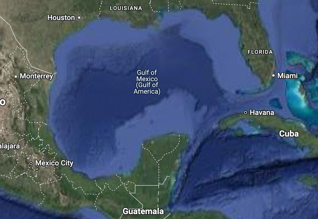
Which acronym will stormcarib.com now use?
What is the point of renaming the Gulf of Mexico to Gulf of
America? But not for all! Internet users from the USA will see it
as "Gulf of America". User from Mexico will still see it as "Gulf
of Mexico". All others will see it with both names as depicted in
the screenshot. What is going on in the head of this stupid person
who initiated it? If anyone can explain that to me I would really
appreciate any reasonable explanation.
It would also be interesting to know what is shown on the google
maps for users from Puerto Rico and the USVIs?
--
Best regards. Be prepared and stay safe and dry! Jurgen,
from Barbados, South, near airport (BGI)
|
|
|
- Strong winds and Waves around Barbados
|
- By Jurgen Starck <weather at turtle48.de>
- Date: Mon, 10 Feb 2025 12:29:11 -0400
|
|
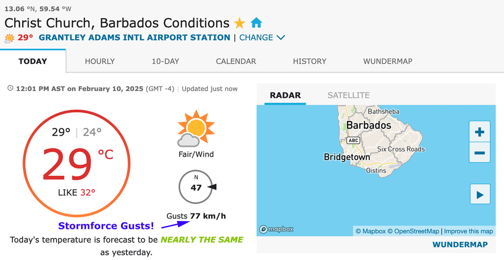
Good day to all!
Since a few weeks Barbados is hammered by high
waves between 2.5 and 3.5 Metres.
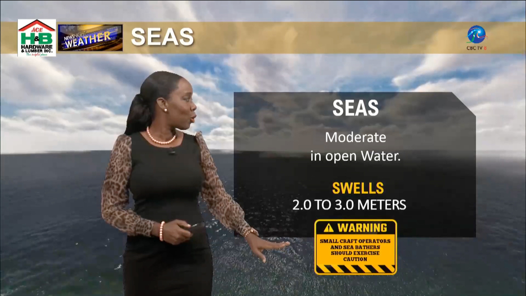
Today the Barbados Airport Weather Station
reported storm force wind gusts.
--
Best regards. Be prepared and stay safe and dry! Jurgen,
from Barbados, South, near airport (BGI)
|
|
|
- Not from above but from below
|
- By Jurgen Starck <weather at turtle48.de>
- Date: Wed, 1 Jan 2025 00:12:37 -0400
|
|
Good night to everyone,
I have just read this article:
https://nationnews.com/2024/12/31/quakes-rock-three-caribbean-countries/
I also think that I may have felt it, because a little shaking
just happens ever so often and I don't really care much about it
much, but I am not sure if it was related to this one.
Having said that, I wish the entire stormcarib.com family a
better and less furious hurricane season for 2025!
Best regards. Be prepared and stay safe and dry! Jurgen,
from Barbados, South, near airport (BGI)
|
|
|
- Saharan Dust for you to see
|
- By Jurgen Starck <weather at turtle48.de>
- Date: Tue, 24 Dec 2024 10:13:33 -0400
|
|
Good morning to all,
in relation to Ann's report below I want to add two photos.
Saharan Dust today - at 8:40 am. It broke the
record of density I have ever seen (see at the bottom of
this page)
The Horizon is totally invisible.
This photo has been taken on a sunny day - at
15:00 hrs.
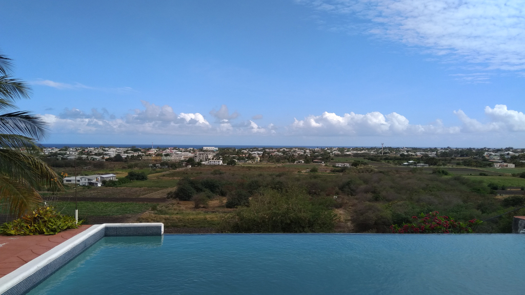
The strait line of the horizon over the blue Atlantic Ocean is
clearly visible.
That's it for today.
I wish everyone a Merry
Christmas and a Happy
New Year!
--
Best regards. Be prepared and stay safe and dry! Jurgen,
from Barbados, South, near airport (BGI)
|
|
|
- Sahara Dust
|
- By Ann Phelan <annlouisephelan at gmail.com>
- Date: Tue, 24 Dec 2024 08:52:26 -0400
|
Just a quick report before I head up to Mullins Bay for a little beach vibe. We
have some significant Sahara dust here in Barbados, but it doesn’t impact the
day at all.  The streets are packed and Barbados is seeing record numbers of
arrivals. In fact Saturday was the number one biggest in their history of
tourism. That says a lot about the island hospitality.

Annie
Sent from my iPhone so my apologies for my brevity and any grammatical errors
|
|
- Update
|
- By Jurgen Starck <weather at turtle48.de>
- Date: Sun, 17 Nov 2024 15:05:09 -0400
|
|
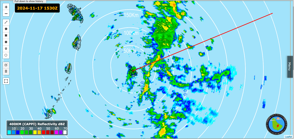
As the saying goes: "The Party is not over until the fat Lady
sings!"
The brunt of the rain is about come, an not just rain! (See the
weather station graphic below)
The airport weather station:
Until next time.
--
Best regards. Be prepared and stay safe and dry! Jurgen,
from Barbados, South, near airport (BGI)
|
|
|
- Barbados under unstable conditions
|
- By Jurgen Starck <weather at turtle48.de>
- Date: Sun, 17 Nov 2024 12:50:27 -0400
|
|
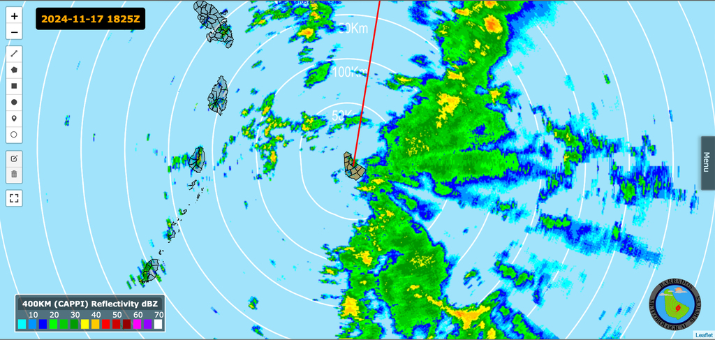
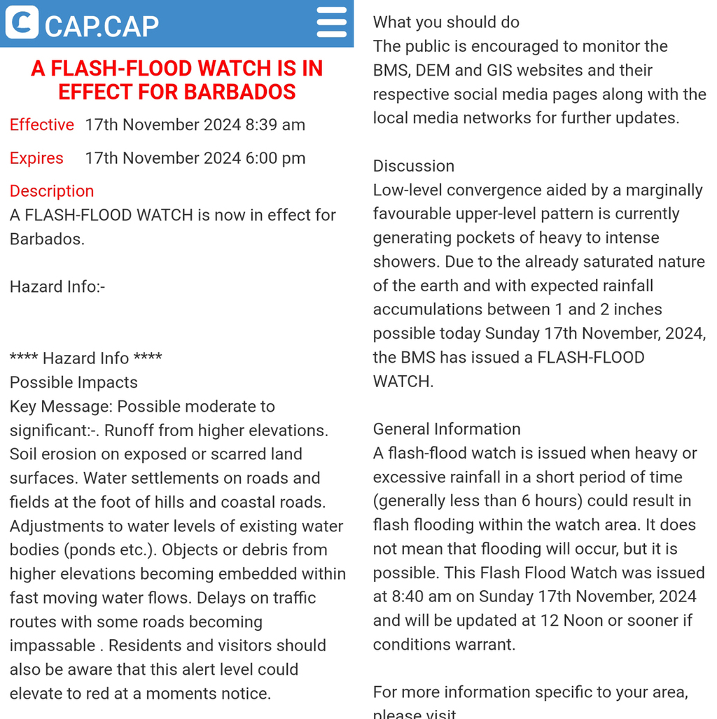
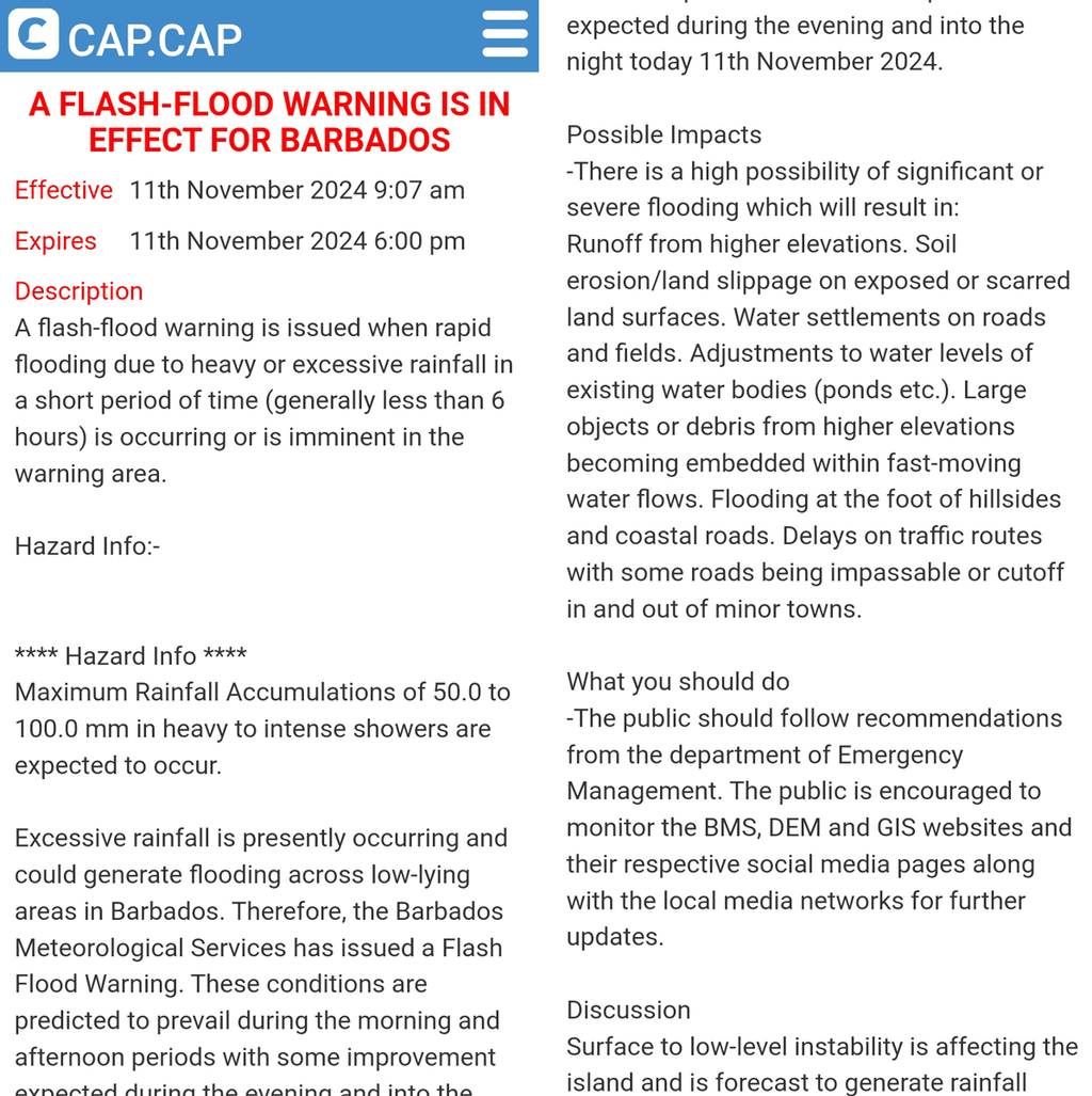
Good day everyone,
the BMS has issued a flash-flood watch for Barbados, due to
unstable conditions over and around Barbados. A rain accumulation
up to 2 inches has been forecast.
Weather Radar, Barbados in the centre of the circles.
Enjoy the rest of the weekend.
--
Best regards. Be prepared and stay safe and dry! Jurgen,
from Barbados, South, near airport (BGI)
|
|
|
- Is the Caribbean Sea a graveyard or now a birthplace for storms?
|
- By Jurgen Starck <weather at turtle48.de>
- Date: Mon, 11 Nov 2024 23:34:30 -0400
|
|
Back to weather,
I just saw this at the NHC website, and I am hoping that our
master forecaster Dave could put some light on this one.
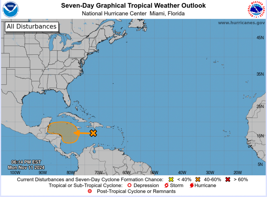
I have lost count of how many storms have started in this region
and in t!his season so far !
Good night to all.
--
Best regards. Be prepared and stay safe and dry!
Jurgen, from Barbados, South, near airport (BGI)
|
|
|
- It's getting wet
|
- By Jurgen Starck <weather at turtle48.de>
- Date: Mon, 11 Nov 2024 10:56:53 -0400
|
|
Good morning everyone,
Barbados is under Flash-Flood Warning. It is forecast, that we
may have rainfall accumulation up to 100 mm!
--
Best regards. Be prepared and stay safe
and dry!
Jurgen, from Barbados, South, near airport (BGI)
|
|
|
- Title correction "if hope" should have been "I hope"
|
- By Jurgen Starck <weather at turtle48.de>
- Date: Fri, 25 Oct 2024 20:22:53 -0400
|
|
Sorry for the confusion.
Good night to all.
--
Best regards. Be prepared and stay safe and dry!
Jurgen, from Barbados, South, near airport (BGI)
|
|
|
- if hope that is reliable
|
- By Jurgen Starck <weather at turtle48.de>
- Date: Fri, 25 Oct 2024 20:07:53 -0400
|
|
Good evening to all,
the following link was in the CBC TV8 NEWS this evening.
https://www.cbc.bb/news/local-news/barbados-set-to-be-emergency-management-hub/
For some reason I think that this might be a good plan for future
coming disasters into this region. I do remember IRMA and MARIA.
Our airport was so busy to take in all sorts of military aircraft
bringing in help from many countries. But where to store all the
goods?
May be, this article above mentioned, may have told Barbados a
lesson as to how to improve it? We'll see...
--
Best regards. Be prepared and stay safe and dry!
Jurgen, from Barbados, South, near airport (BGI)
|
|
|
- Two new Storms in one day !
|
- By Jurgen Starck <weather at turtle48.de>
- Date: Sat, 19 Oct 2024 16:25:45 -0400
|
|
Good evening all,
today I made some very new experiences, since I am observing
storms in the Atlantic Basin.
1. Two new storms in one day! TS NADINE and at the time of
writing and later on H1 OSCAR!
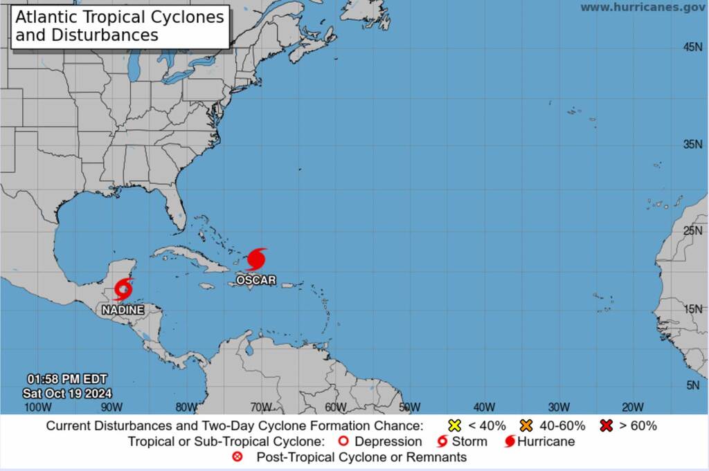
2. OSCAR is a record holder on its own already. Jumping from
INVEST 94L straight to a TS skipping the TD status (seen that
before) but then, within an hour to a H1 Hurricane is a new one to
me. I am sorry for the people in Turks and Caicos as well as
Hispaniola, East Cuba, the Bahamas and may be Puerto Rico. The RI
(Rapid Intensification) is also new to me, because OSCAR is really
small, but another record as to my memory. Well, the lack in size
may hopefully dampen the impact for our friends in the Northern
Caribbean and beyond.
3. H1 OSCAR will not spend much time around the Northern
Caribbean, after it is doing a very sharp to the North East. I can
only hope that he will not do another sharp right right turn once
he is in the open Atlantic and come back to us again. In this
season you just cannot be sure about anything.
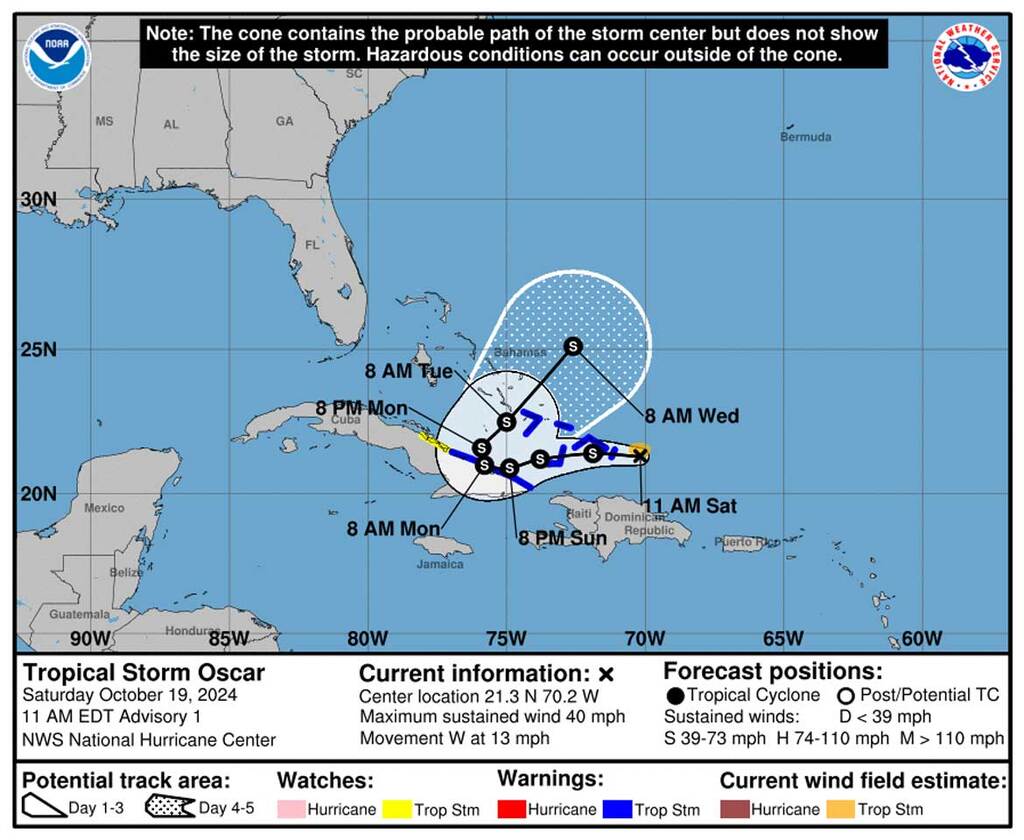
May you all have a good evening and watch out!
--
Best regards. Be prepared and stay safe and dry! Jurgen,
from Barbados, South, near airport (BGI)
P.S.: This report is not meant to be a
forecast. It is just my interpretation of what I am seeing.
|
|
|
- Latest news by NHC
|
- By Jurgen Starck <weather at turtle48.de>
- Date: Thu, 26 Sep 2024 20:37:23 -0400
|
|
Good evening to everyone,
Just for those of you who don't know and may friends or relatives
in Florida or near by, HELENE is now a Cat 4 Hurricane!
--
Best regards. Be prepared and stay safe and dry! Jurgen,
from Barbados, South, near airport (BGI)
|
|
|
- Food for thought
|
- By Jurgen Starck <weather at turtle48.de>
- Date: Fri, 13 Sep 2024 20:17:15 -0400
|
|
Good evening to everyone,
may the following article may be the explanation why we had so
little storms for now? When these storms release all the energy
over the Sahara then there is not much left for the Atlantic.
https://edition.cnn.com/2024/09/13/weather/sahara-desert-green-climate/index.html
It sounds somehow reasonable to me.
Good night.
--
Best regards. Be prepared and stay safe and dry! Jurgen,
from Barbados, South, near airport (BGI)
|
|
|
- Interesting Article
|
- By Jurgen Starck <weather at turtle48.de>
- Date: Sat, 7 Sep 2024 10:18:54 -0400
|
|
|
|
- All eyes on this one
|
- By Jurgen Starck <weather at turtle48.de>
- Date: Tue, 27 Aug 2024 10:49:33 -0400
|
|
Good morning everyone,
all eyes should be put on this one. Too early to say if it will
develop into something, before it is reaching the eastern
Caribbean islands.
Disturbance 1
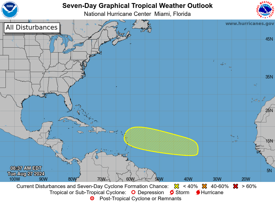
Stay vigilant everyone.
--
Best regards. Be prepared and stay safe and dry! Jurgen,
from Barbados, South, near airport (BGI)
|
|
|
- PTC FIVE trending north
|
- By Jurgen Starck <weather at turtle48.de>
- Date: Sun, 11 Aug 2024 23:38:04 -0400
|
|
Good night to everyone,
Dave was dead right with his latest post. INVEST 98L is now a PTC
FIVE. And when I look at the trends wich way that system it going
to, it seems to me it is trending more and more northwards bit by
bit. Away from Barbados and may be more focussed to the Leeward
Islands now. So you people up there take care an be prepared. This
is not me to make a forecast, I am just reporting what I have seen
so far.
Even by NHC graphics I have seen a trend that PTC FIVE is
drifting his way more and more to the North. Well, good for the
Windward Islands, but not so much for Leeward Islands.
Also, two Hurricane Hunters have landed in Barbados today. They
will probably take on there missions tomorrow.
Two Hurricane Hunters arrivals
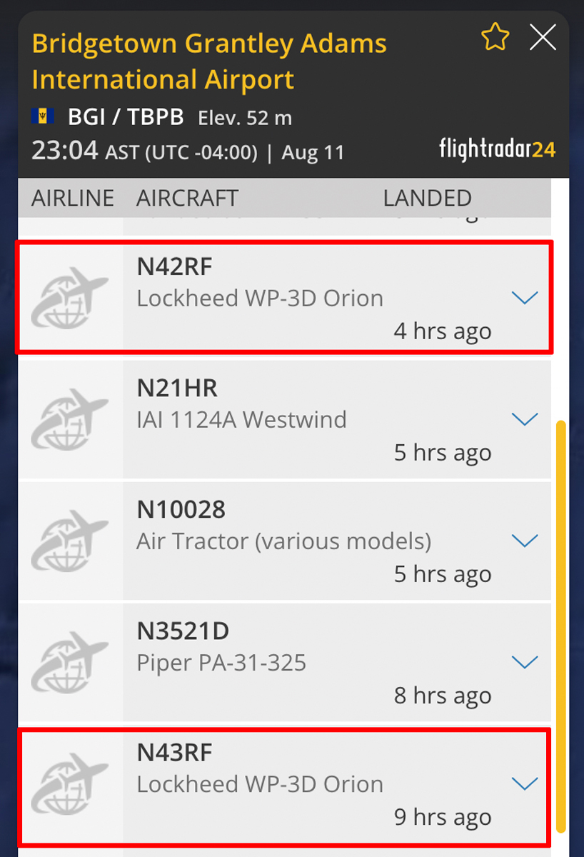
That's it for tonight.
--
Best regards. Be prepared and stay safe and dry!
Jurgen, from Barbados, South, near airport (BGI)
|
|
|
- Update to my last post
|
- By Jurgen Starck <weather at turtle48.de>
- Date: Sat, 10 Aug 2024 23:17:14 -0400
|
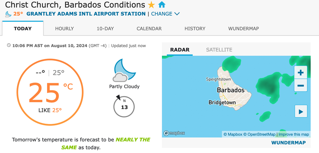
|
Winds have changed to not come in from a westerly direction they
are coming in from straight north until now.
Barbados weather station reading as of now.
Winds are clearly coming in from straight Noth. Hence, pilots can
chose which direction they want to come in or take-off. Well, this
is not my problem to discuss.
Good night again.
--
Best regards. Be prepared and stay safe and dry!
Jurgen, from Barbados, South, near airport (BGI)
|
|
|
- INVEST 98L
|
- By Jurgen Starck <weather at turtle48.de>
- Date: Sat, 10 Aug 2024 22:16:16 -0400
|
|
Good night to everyone,
according to the Barbados Meteorological Service (BMS) INVEST 98L
will pass Barbados Monday into Tuesday. However, the first
indicators of turning winds are already here. Winds have a
westerly component and air traffic has changed directions for
arrivals and departure.
.
The BMS CAP statement
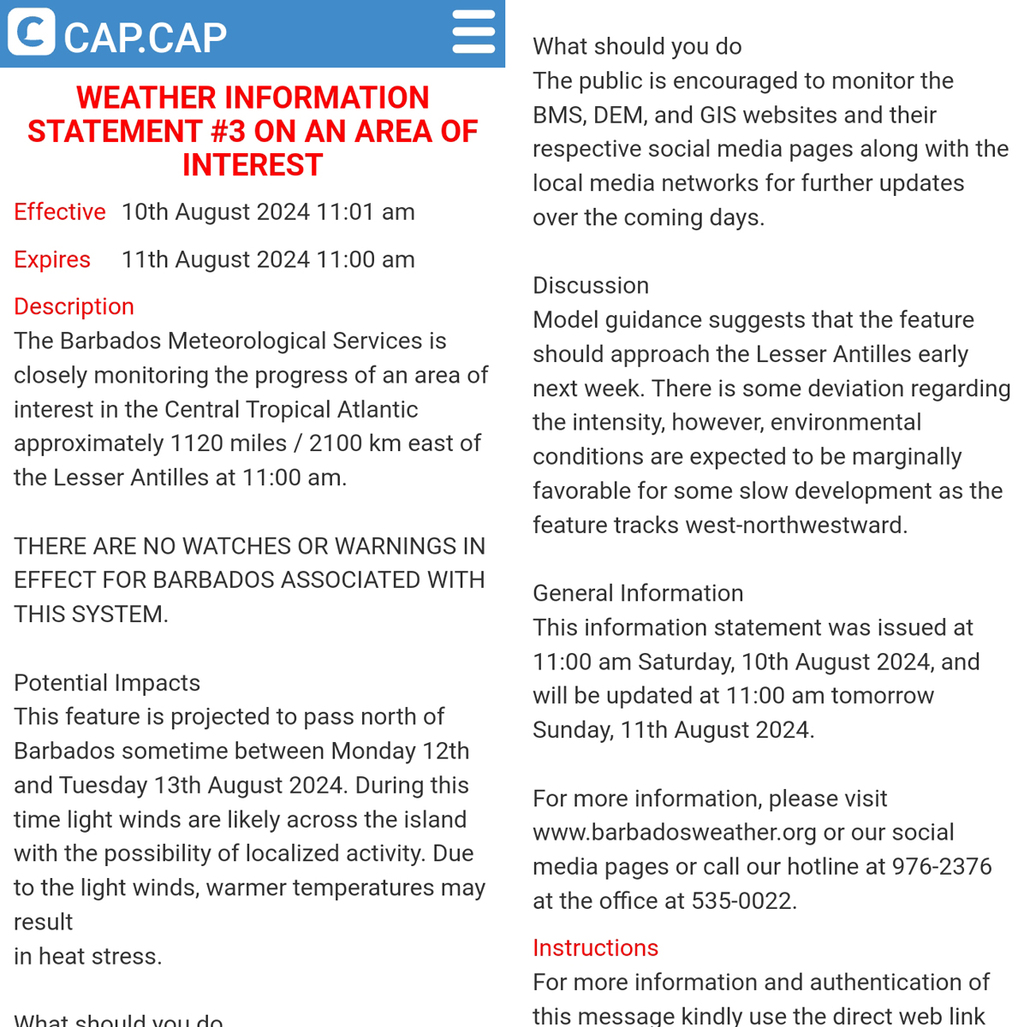
Barbados airport weather station reading
I will update more as soon s available.
Good night to all.
--
Best regards. Be prepared and stay safe and dry!
Jurgen, from Barbados, South, near airport (BGI)
|
|
|
- Tropical Wave passing through
|
- By Jurgen Starck <weather at turtle48.de>
- Date: Sun, 4 Aug 2024 23:34:38 -0400
|
|
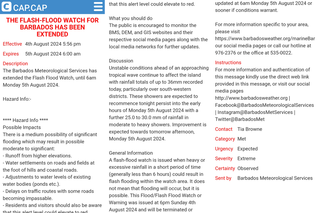
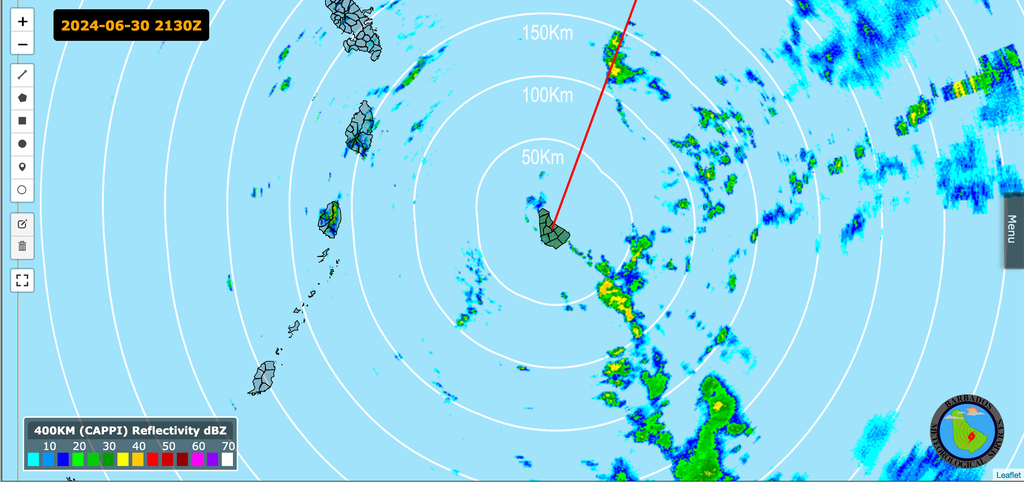
Good night to everyone,
today a Tropical Wave with lots of rain and thunder storms was
passing through. However, that had nothing to with what the NHC is
currently calling Disturbance 1. It was just a Tropical Wave which
the NHC had not even on their screens.
BMS Radar image
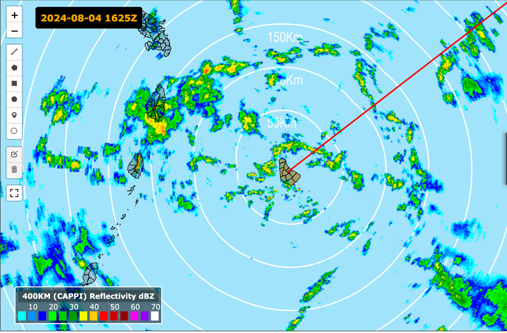
It brought a lot of rain to Barbados,
at least in my area.
Therefore, Barbados was under a Flash-Flood
Watch which still exists
That's it for tonight.
--
Best regards. Be prepared and stay safe and dry!
Jurgen, from Barbados, South, near airport (BGI)
|
|
|
- H4 BERYL aftermath for Barbados
|
- By Jurgen Starck <weather at turtle48.de>
- Date: Tue, 9 Jul 2024 22:01:42 -0400
|
|
Good evening everyone,
it took me a while to research what really has happened around
Barbados by watching videos about the coast lines and beaches of
Barbados. So here comes just an explanation of the consequences as
far as I can estimated them and a few before and after photos.
The first Major Hurricane of this season, which has passed
Barbados just so. No hurricane-force winds in Barbados or maybe a
few cat1 gusts here and there. The winds were not a cause for
damages at the coast lines. The storm surf has caused a lot of
damage to Barbados! The fishing industry is disabled for a long
time. Not only that, this incredible storm surf has caused a lot
of beach erosion around the island. In some cases also structural
damage to seaside properties. And yes, some inland houses were
damaged by winds. Barbados can deal with the latter. But what
happens, once the word goes around that "beautiful Barbados" has
no beaches left? Then the tourism industry will almost die as
well! How to fix that? There is no way that Barbados can fix that.
Only nature can bring these beaches back, but how many years would
take that?
I guess everyone can rethink that for him- or herself.
You may watch these videos here: https://www.youtube.com/@bajanwarrior
Look at the section "Past live streams". Please, note the right
arrow on the right hand side of this section list and click
through it. That will show all available videos about damages to
our beaches. The Author is "Barbados - The Journey 246" aka at bajanwarrior.
--
Best regards. Be prepared and stay safe
and dry! Jurgen, from Barbados, South, near airport (BGI)
|
|
|
- TRIBUTE to Carriacou and other small islands hit by BERYL
|
- By Jurgen Starck <weather at turtle48.de>
- Date: Fri, 5 Jul 2024 14:17:53 -0400
|
|
Hello everyone,
this is not a report.
A bit about me first: I am not a man who can be
impressed easily and neither I am getting emotional of many
things just so. However, there was one thing that really caught
me! Hurricane Beryl! What actually caught me, was the visual
satellite photo provided by Brian McNoldy and Gert has kindly
posted it on the front page of this great website. The light
green overlay of the Windward Islands chain and little Island
Carriacou right in the centre of the eye. This tiny Island could
have fit 3 times into the eye of Beryl! When I have seen this
image my first thought was "Ooooh, my! That couldn't end well!" And so it came! There is hardly
anything left of this little paradise, as you can see in the
section "Carriacou after Hurricane Beryl". But one thing made me
happy, no fatalities, as far as I know for now!
This, whole tragedy has driven me to write this
tribute. It also made me aware how fragile our islands are and
how lucky Barbados has been, even though we have had tremendous
material damage, mostly at the coast lines. Also, almost the
entire fishing industry is out of job for a long time. Barbados
has only a stock of frozen fish for about two weeks left. Also,
as I have learned today, A lot of beaches on the South and West
Coasts have been washed away. A big hit to our no. 1 money
maker, the tourism industry!
Back to my main subject: This Tribute is not meant
to be sensational, it is just meant to be informal and to remind
all off us in this region how quickly lives can change!
"It only needs one!"
TRIBUTE TO CARRIACOU and all
other small islands hit by Hurricane BERYL, Cat 4 in
2024-07-01 11:10
CARRIACOU BEFORE HURRICANE BERYL
https://www.youtube.com/watch?v=41L5Nq2Lk64 Drone footage, few
villages in Carriacou. (11:44 min.)
https://www.youtube.com/watch?v=n-yqkp1nRUM D'Pearl - Windward,
Carriacou (Grenada) (2:39 min.)
https://www.youtube.com/watch?v=n00XkJc47HE Directly in the path of
Hurricane Beryl: Carriacou's Last Day of Calm (15:40 min.)
CARRIACOU DURING HURRICANE
BERYL - CATEGORY 4 2024
https://www.youtube.com/watch?v=N7ce0TUdiGc Hurricane Beryl
Landfall Carriacou raw power 4k - Eye wall of category 4 (8:23
min.)
CARRIACOU AFTER HURRICANE BERYL -
CATEGORY 4 2024
https://www.youtube.com/watch?v=iSY8Vz1Mvuk Hurricane Beryl's
Aftermath: Carriacou Residents' Survival Stories (9:10 min.)
https://www.youtube.com/watch?v=WOy62qojiFg Touring Carriacou After
Hurricane Beryl's Devastation (17:39 min.)
https://www.youtube.com/watch?v=xrKJSlFD_rk Drone Shows Hurricane
Beryl Destruction on Carriacou Island (1:57 min.)
https://www.youtube.com/watch?v=-raESMVS9LM Hurricane Beryl Damage -
Carriacou, Grenada - Windward side (11:29 min.)
https://www.independent.co.uk/climate-change/news/hurricane-beryl-damage-carriacou-island-carribean-b2573245.html
Seven people killed and islands flattened as hurricane Beryl
devastates Caribbean
https://www.cbc.bb/news/regional-news/us-extends-support-to-grenada-svg-after-hurricane-beryl/
US extends support to Grenada, SVG after Hurricane Beryl
THIS IS WORTH TO BE REMEMBERED
https://www.youtube.com/watch?v=e3jx7DNu6yo Brave Barbados P.M
Publicly Expose America and Europe's Hypocrisy. (11:06 min.)
--
Best regards. Be prepared and stay safe and dry! Jurgen,
from Barbados, South, near airport (BGI)
|
|
|
- TRIBUTE to Carriacou and others
|
- By Jurgen Starck <weather at turtle48.de>
- Date: Thu, 4 Jul 2024 20:57:31 -0400
|
|
Good evening to everyone,
this is going to be a bit of an unusual report, but when I saw
that impressive satellite image, as a visual satellite photo on
the stormcarib.com front page, provided by Brian
McNoldy, Univ. of Miami, it really
hit me!
I am not generally a person that can be overwhelmed by photos
or emotions or being impressed by even new things that are going
around in the news or where ever. At this time the world are
living to face a new nature defence.
However, when I saw this little island of Carriacou, it really
caught me deeply! Having seen this satellite image where this
small island of Carriacou could have easily fit 3-times into the eye of H4
BARYL! Just imagine that! It really has touched me! My emotions
have come back to life! I don't know if that is bad or good.
However, this is the reason for this report.
And therefore I am going send a list of links of
videos which I have found on the internet lately until today. I
took me a lot of time to find them. But my emotions made it
worth while!
This list is to come up tomorrow. I am tired now.
Wait for it.
Good night to everyone
--
Best regards. Be prepared and stay safe and dry! Jurgen,
from Barbados, South, near airport (BGI)
|
|
|
- One more report
|
- By Jurgen Starck <weather at turtle48.de>
- Date: Wed, 3 Jul 2024 12:10:44 -0400
|
|
This report I have just found. It is about Oistins a town in the
south of Barbados. Oistins fish market and the adjacent "Oistins
Bay Garden", well known for his Friday's fish fry and Karaoke, was
just renovated and improved for about 5 Million BBD. It was also
hit hard by water and tons of sand washed into the stalls.
https://www.youtube.com/watch?v=JjmPFCN6_8Q Oistins Recovery
Have a good day.
--
Best regards. Be prepared and stay safe and dry! Jurgen,
from Barbados, South, near airport (BGI)
|
|
|
- H4 BERYL: Reports in the media
|
- By Jurgen Starck <weather at turtle48.de>
- Date: Wed, 3 Jul 2024 11:10:31 -0400
|
|
|
|
- H4 BERYL reports - just one for a start
|
- By Jurgen Starck <weather at turtle48.de>
- Date: Tue, 2 Jul 2024 22:59:35 -0400
|
|
Good night everyone,
I am sorry not be able to post news from Barbados as I have
promised. But news were just overwhelming me plenty. Local news as
well as international news.
As a little effort to keep my promise I will post a link here
from a German news provider. Well, the audio is obviously German
language, but the pictures are saying more than the audio.
https://www.tagesschau.de/ausland/amerika/hurrikan-beryl-106.html
I am no sending this because I am a German but it is the most
comprehensive report I have ever seen from a foreign news agency.
The video is speaking for itself.
I will post a report of all of what I have found tomorrow, be
aware of a long list to come.
Good night.
--
Best regards. Be prepared and stay safe
and dry! Jurgen, from Barbados, South, near airport (BGI)
|
|
|
- BERYL: Heavy damages in Barbados !
|
- By Jurgen Starck <weather at turtle48.de>
- Date: Mon, 1 Jul 2024 22:10:10 -0400
|
|
Good evening everyone,
there have been heavy damages in Barbados. Mainly to the fishery
complex in Bridgetown! Storm surge was the major culprit. 20 boats
sunk and many others damaged, including 2 pleasure crafts. The
market itself was was flooded with lots of muddy waters. It is a
total mess down there.
25% of power customers were out of power spread over the island
with local limited outages, but reparations have begun after the
"all clear" was announced at 14:00 hrs today.
Water is still out! Not a drop coming from the taps. At 14:00 hrs
they could have started to resume the water supply! But not!
The Airport tried to reopen service by 21:00 hrs today. I have
not checked that as yet.
I will write more once I have some sure information.
Good night for today.
--
Best regards. Be prepared and stay safe and dry! Jurgen,
from Barbados, South, near airport (BGI)
|
|
|
- Shut downs
|
- By Jurgen Starck <weather at turtle48.de>
- Date: Sun, 30 Jun 2024 23:26:06 -0400
|
|
|
|
- The "Bad Girl" is closing in
|
- By Jurgen Starck <weather at turtle48.de>
- Date: Sun, 30 Jun 2024 21:42:50 -0400
|
|
Good evening everyone,
the first harbingers of the "Bad Girl", as Dave has called her so
rightly, are here. I hope Dave will not charge for using this
nickname. 😉
Winds: The airport
weather station noted close to storm force gusts
Rain: The BMS weather radar recorded rain
clouds from a feeder band
Be assured, we got that rain and the gusts.
May you all have a good night and a weekend with not too much
stress, depending on where you live!
--
Best regards. Be prepared and stay safe and dry! Jurgen,
from Barbados, South, near airport (BGI)
|
|
|
- Latest news: H4 BERYL ?
|
- By Jurgen Starck <weather at turtle48.de>
- Date: Sun, 30 Jun 2024 10:07:49 -0400
|
|
Good morning all,
the latest news from ZOOM.earth are frightening! Watch the red
rectangular label in the centre of the graphic!
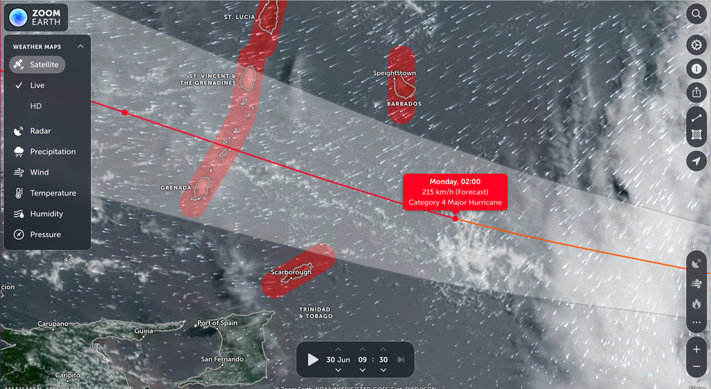
May everyone get well through this mess!
--
Best regards. Be prepared and stay safe and dry! Jurgen,
from Barbados, South, near airport (BGI)
|
|
|
- CAP Warnings as of today
|
- By Jurgen Starck <weather at turtle48.de>
- Date: Sat, 29 Jun 2024 15:32:28 -0400
|
|
Good afternoon again,
CAP small craft and high surf warning (10:00
hrs today)
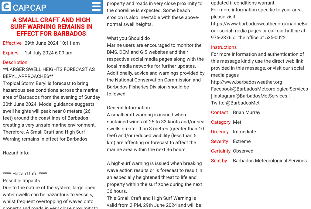
CAP Hurricane Watch in effect for Barbados
(14:00 hrs today)
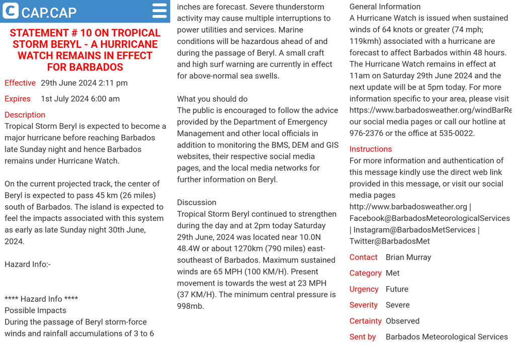
That is it for now.
--
Best regards. Be prepared and stay safe and dry! Jurgen,
from Barbados, South, near airport (BGI)
|
|
|
- Holy Crap! Barbados is now awaiting a Cat2 BERYL! The Windwards to our Wesz even a Cat3 Hurricane!
|
- By Jurgen Starck <weather at turtle48.de>
- Date: Sat, 29 Jun 2024 14:20:29 -0400
|
|
Good afternoon all,
all of a sudden we have to deal with a Cat2 or Cat3 hurricane!!! Meanwhile the BMS and NHC are still forecasting a Cat3 Hurricane for the Windward Islands
H2 BERYL forecast to pass Barbados (note: this can still
change!)
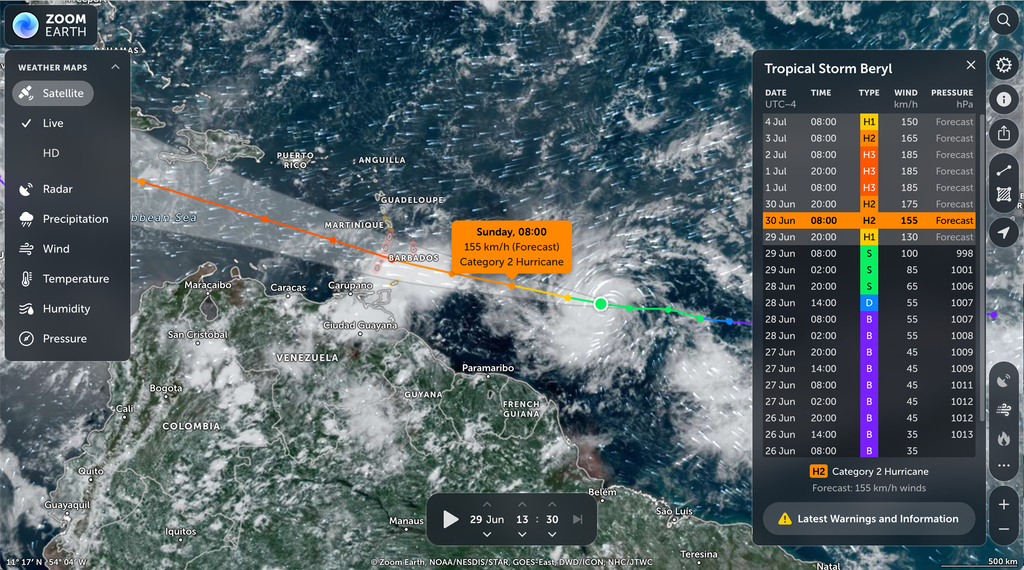
H3 BERYL forecast to cross the Windwards (however,
this is not carved in stone!)
I suggest to rethink your preparations for securing lose stuff
around your properties.
This not a joke!
I will send the latest CAP Statements in a few minutes.
--
Best regards. Be prepared and stay safe and dry! Jurgen,
from Barbados, South, near airport (BGI)
|
|
|
- This might surprise some of you
|
- By Jurgen Starck <weather at turtle48.de>
- Date: Fri, 28 Jun 2024 21:29:49 -0400
|
|
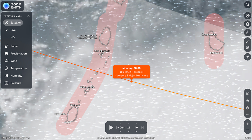
Good evening all,
the NHC as well as the BMS are predicting that Tropical
Depression TWO is about to pay a visit to the Windward Islands as
a Tropical Storm. Well, ZOOM.earth sees it a bit different. See
graphic below:
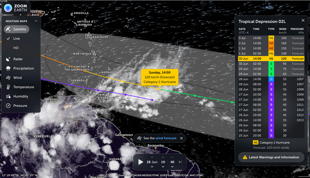
This graphic clearly shows that TD TWO will be become a hurricane
on Jun 30eh at 14:00 hrs., way before it will reach Barbados! And
also look at the the orange line close to St. Vincent and the
Grenadines and may be even Grenada, it is forecast to become a
cat2 hurricane!
Good night to all.
--
Best regards. Be prepared and stay safe and dry! Jurgen,
from Barbados, South, near airport (BGI)
|
|
|
- Forecasts of BMS are closing on a possible Beryl !
|
- By Jurgen Starck <weather at turtle48.de>
- Date: Thu, 27 Jun 2024 18:56:28 -0400
|
|
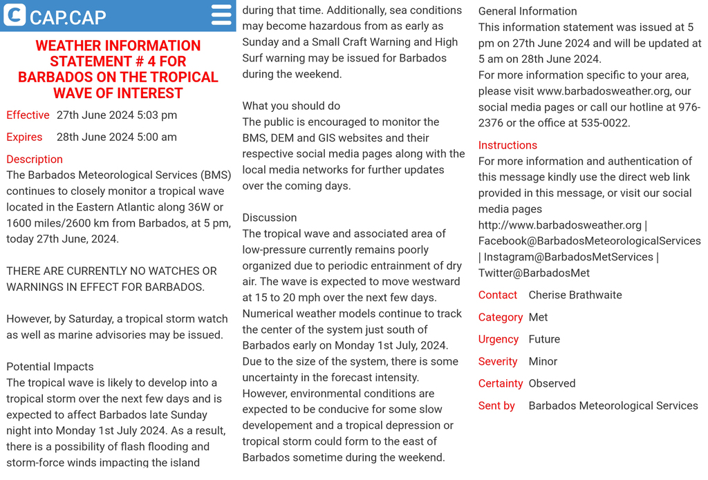
Good evening all,
the latest CAP statement of the BMS (second image) is getting
close to forecast a possible TS passing shortly South of Barbados
over the weekend ahead. Since the size of that system is not yet
defined, due to current disorganisation it is hard to predict
which other islands might be in the path of this system.
Therefore, I don't want to speculate which of our neighbours might
also be in the cross hairs. However, for now the track seems to be
generally West. So, everyone in the path may want to watch
reliable news outlets and go figure.
The latest BMS Wind Bulletin
The BMS CAP Weather Statement
I repeat: Listen to your most reliable news
outlets!
Alternative: You can also watch
https://www.cbc.bb/live/ the local Barbados TV online stream.
Weather will usually be presented Mon.-Fri. around 19:40 and
Sat.-Sun. around 19:25. I recommend to tune in a few minutes
earlier.
Now, let's see what the weekend will bring us... Cross all your
fingers!
Good night to all!
--
Best regards. Be prepared and stay safe and dry! Jurgen,
from Barbados, South, near airport (BGI)
|
|
|
- Wind Warning from the BMS for Barbados
|
- By Jurgen Starck <weather at turtle48.de>
- Date: Mon, 24 Jun 2024 21:04:11 -0400
|
|
Good evening to all,
the Barbados Meteorological Service (BMS) has published a wind
warning statement for Barbados. As it looks like for now it will
only affect the Windward Islands.
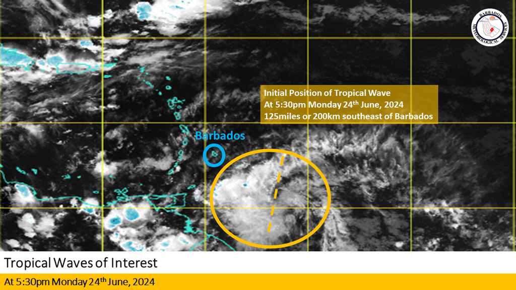
You may find more detailed information here:
https://www.barbadosweather.org/ However that link will be only
valid for tonight! because it is an online up-to-date service.
--
Best regards. Be prepared and stay safe and dry! Jurgen,
from Barbados, South, near airport (BGI)
|
|
|
- I agree with with Frank from Nevis, BUT!?
|
- By Jurgen Starck <weather at turtle48.de>
- Date: Sat, 15 Jun 2024 23:04:40 -0400
|
|
Good night to all,
there were and still are so many long term season forecasts
published, but as Frank from Nevis has pointed out, there wasn't
even an "early bird" before June. We had that for several years
before, but not every year. We also head like a dozen (not
counted) number of tropical waves coming through this season
already, but none have developed into something concerning storms,
but may be rain. Not saying I am complaining about it as long as
they are bringing some rain in a decent amount. I am not waiting
for a storm!
But what does that mean? Where are the long term forecasters when
it will really happen? Are we going to get all these predicted
storms form a "natural machine gun" within a period of one, two or
three months, or what?
What does NOAA/NHS have to say? There screens are close to blank.
Dave, do you have an explanation?
--
Best regards. Be prepared and stay safe and dry! Jurgen,
from Barbados, South, near airport (BGI)
|
|
|
- Three Tropical Waves approaching the Eastern Caribbean
|
- By Jurgen Starck <weather at turtle48.de>
- Date: Thu, 6 Jun 2024 23:32:14 -0400
|
|
Good night to all,
the Barbados Meteorological Service (BMS) has just stated in the
local evening TV news, that there are 3 Tropical Waves (TW) are
heading to the Eastern Caribbean. The first one (TW1 in my Graphic
below) is heading to the Leeward Islands. Hence, you people up
there should take an eye on that one.
The second one (TW2) is supposed to come in lower and may impact
the lower eastern Caribbean islands.
The third TW (TW3) is still too far out to the Eastern Atlantic
to make any reliable predictions.
Watch out for all of them according to where you live!
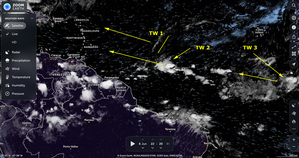
The ZOOM.EARTH is a NOAA product. But the NHS still has none of
these TWs on their screens.
May be the BMS has become to be too conservative with their
forecasts. But better being conservative rather than missing a
disaster!
--
Best regards. Be prepared and stay safe and dry! Jurgen,
from Barbados, South, near airport (BGI)
|
|
|
- CIMH Hurricane Season forecast for our region
|
- By Jurgen Starck <weather at turtle48.de>
- Date: Thu, 23 May 2024 19:25:14 -0400
|
|
|
|
- Thickest dust haze I have ever seen
|
- By Jurgen Starck <weather at turtle48.de>
- Date: Sun, 5 May 2024 18:05:07 -0400
|
|
Good evening all!
Just a few minutes ago I have taken this photo, with the thickest
dust haze I haver seen in the 15 years I live in this place.
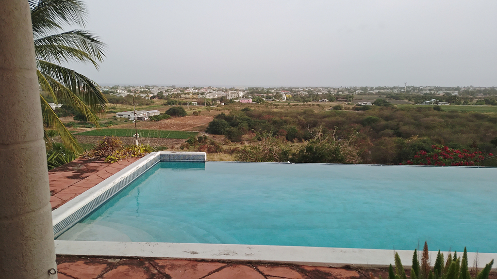
And there is more to come according to the Barbados
Meteorological Service (BMS). The relief is forecast to begin on
Wednesday for Barbados.
Affected persons with respiratory illnesses should have all their
medications and/or inhalers at hand when leaving their homes. And
don't forget to up the before mentioned items.
Good night everyone!
--
Best regards. Be prepared and stay safe and dry! Jurgen,
from Barbados, South, near airport (BGI)
|
|
- Saharan dust haze is about to come back
|
- By Jurgen Starck <weather at turtle48.de>
- Date: Thu, 2 May 2024 19:35:17 -0400
|
|
Good evening All!
The Saharan Dust Haze makes a return.
The CAP BMS information statement:
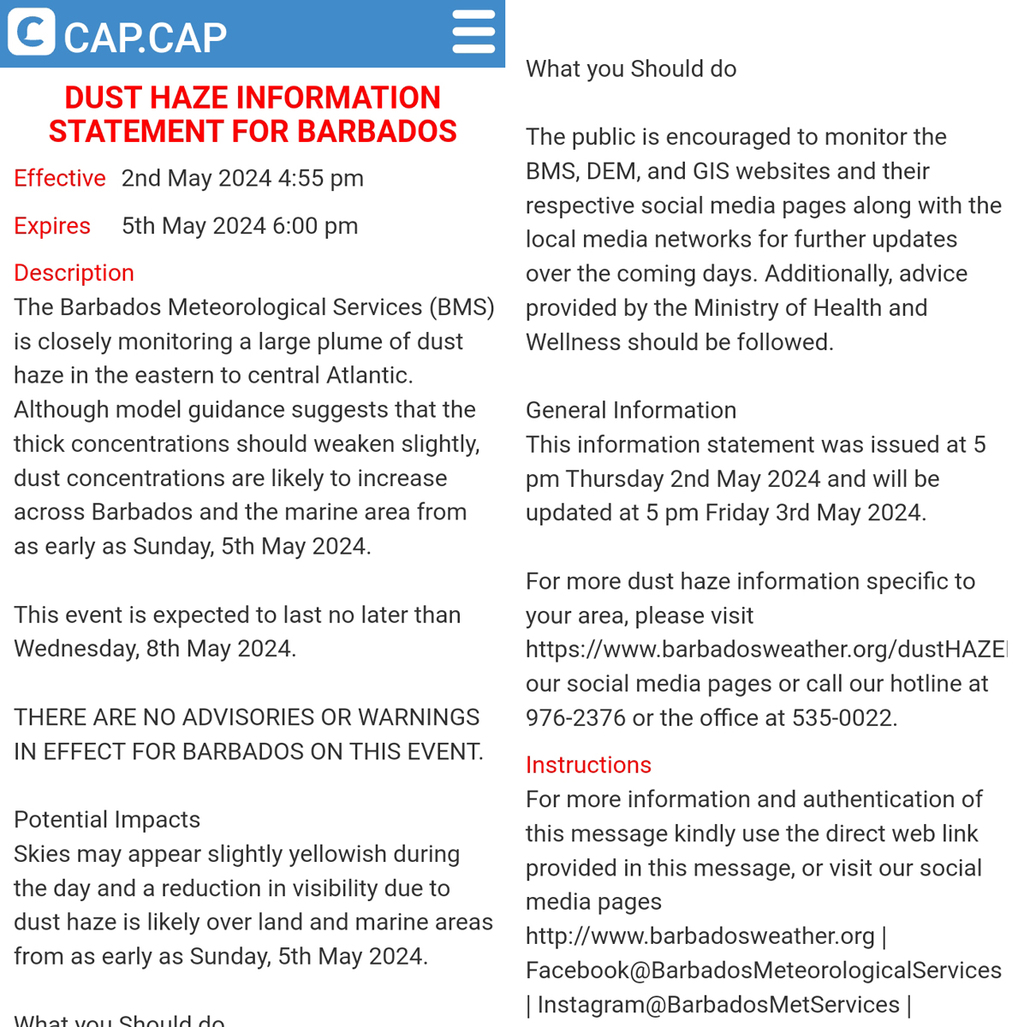
I spare myself a screenshot of the plume to come, because it
looks almost the same, like the one in my previous report.
However, if someone wants to follow it up, you can do that here:
https://zoom.earth/maps/satellite/#view
But be aware, that link only shows it properly once the sun is up
in our region and across the Atlantic back to where plume is
coming from.
Good night to all.
--
Best regards. Be prepared and stay safe and dry! Jurgen,
from Barbados, South, near airport (BGI)
|
|
