[stormCARIB - Caribbean Hurricane Network'

Caribbean Hurricane Network

- 2 0 0 8  Season -

| home | tools | pleas for help | QHWRN | guide | climatology | archive

2008 Atlantic Hurricane Season
| Arthur | Bertha | Cristobal | Dolly | Edouard | Fay | Gustav | Hanna | Ike | Josephine | Kyle | Laura | Marco | Nana | Omar | Paloma | Rene | Sally | Teddy | Vicky | Wilfred |

The 2008 Hurricane Season felt like a very long one (at least for me...)! Esp. Haiti seemed to be in the path of 4 drenching storms in a row (Fay, Gustav, Hanna and Ike). This season produced some storms we will never forget. Ike in Turks and Caicos, Paloma in the Cayman's and another late storm Omar, although not that big, caused plenty of headache in US and British Virgin Islands, St.Maarten/St.Martin. Below a satellite image I enhanced of Paloma near Cayman Brac, and a little timeseries of the eye traveling past the Cayman's, something we don't like to see again next year... Thanks again to all the excellent volunteer hurricane correspondents for sending in their updates from the islands! -Gert

GOES Visible 1km Nov.8, 7:15AM Cayman Time

Paloma as it passed over Little Cayman and Cayman Brac
(times are local time)
3:45AM4:45AM 5:45AM

Grand Cayman is the 'big' island bottom left, the little specs in the eye wall are Little Cayman (left)
and Cayman Brac (right). Many more high resolution satellite images can be found here.

The heart of the Caribbean Hurricane Network are the personal reports send in by the special hurricane correspondents on the islands. Find out what happened on your favority island during the 2007 Hurricane Season by following the links below.
  - Bonaire [May 19 14:56]
- Mexico (incl. Cozumel & Cancun) [May 19 10:56]
- Culebra (PR) [May 19 7:20]
- Turks & Caicos [May 19 7:13]
- St.Croix [May 19 6:58]
- Dominican Republic [May 19 6:23]
- Tortola [May 19 6:21]
- Curaçao [May 18 20:36]
- St.Maarten/St.Martin [May 18 10:12]
- Jamaica [May 17 20:45]
- St.Thomas [May 17 8:58]
- Nevis [May 13 9:48]
- Montserrat [May 13 7:56]
- Dominica [May 12 21:24]
- Antigua [May 12 14:56]
- St.Vincent & Grenadines [May 7 16:57]
- Guadeloupe [May 5 20:13]
- St.John [May 5 1:46]
- Vieques (PR) [May 4 9:37]
- Puerto Rico [Apr 22 5:40]
- Cayman Islands [Apr 1 14:32]
- Grenada [Mar 28 9:15]
- Bahamas [Feb 16 0:00]
- Saba [Jan 2 13:21]
- Aruba [Dec 31 13:23]
- Trinidad & Tobago [Dec 21 9:23]
- Barbados [Dec 4 17:02]
- St.Kitts [Nov 13 18:06]
- Honduras [Nov 6 5:44]
- Belize [Nov 1 15:29]
- St.Barts [Oct 25 4:42]
- Anguilla [Oct 21 14:41]
- St.Lucia [Oct 17 22:49]
- General Update [Oct 17 17:35]
- Statia [Oct 17 15:55]
- Jost van Dyke [Oct 16 8:33]
- Haiti [Sep 24 15:50]
- Florida Keys [Sep 10 1:00]
- Cuba [Aug 17 12:32]
- Bermuda [Jul 15 16:56]

Following is an archive of all weather discussions Dave and I posted. They are in reverse chronological order, with the most recent storm discussion on top. If you want more background information on specific storms, I have found the 2008 Atlantic Hurricane Season section in the Wikipedia a great resource. Also, visit the Hurricane Research Division of NOAA's Atlantic Oceanographic and Meteorological Lab for 'best track' data of all 2008 storms. The track map below is from that website as well.


- - 2008 Hurricane Tracks - -

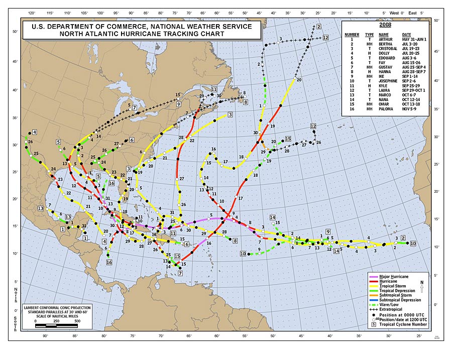
- - Source: NOAA/AOML Hurricane Research Division (click on image for larger size) - -

- - - 2008 Season - - -

Note that reports are in reverse chronological order. It's easiest to start at the bottom and scroll upwards.

Tue, 5 May 2009 08:41:19 -0400 - Rain!

Good morning!
 
The day after another colorful St. Thomas Carnival celebration ended, the May rains came with a vengeance. May is one of the islands wettest months of the year and follows several months of dryness where an ugly brown hue takes over the vegetation and numerous lumbering, expensive water trucks crawl excrutiatingly slow up anddown the hills/mountains of our islands. After this week ends, I'll expect a few of them to take a vacation as it's expected to rain for most of the week although not in the mass quantities of yesterday.
 
Radar out of San Juan, (when it works lately) indicated parts of the islands received 10-12 inches. I believe most of that fell over St. John as a train of showers and thunderstorms slowly worked their way northwest then north necessitating a flash flood watch to be issued just for that island in the morning hours but has since been extended to cover all of our islands. St. Croix is expected to bear the brunt today with more to come Wednesday and Thursday according to NWS computer models.
 
The "towel brigade" was not at all happy to come out of their winter hibernation but I had to roust them when I made it home to stymie the flow of seeping water from my one partially sealed cistern. A quick hook-up of the sump pump and a few feet of hose and water was soon pouring from the not so sealed one into the mostly sealed one. After about two hours the seeping stopped and the wet-vac was returned to winterized dry-vac mode! Happy the rain stopped when it did before I reached home as I already had visions of three inches in my kitchen/living room! Hey, a good test for upcoming season which is less than a month away ALREADY!!
 
Two things to note with all of this rain:
 
One, Guess who's coming back to dinner? Is that your final answer? Correct. Mosquitoes!!!!! Get rid of ponding and standing water as first, the little no-seeums will show up followed in a week or so by the airborne division of helicoptor mosquitoes! Check your screens and entryways for ways these little, no-redeeming qualities, form of pest can get inside your home.
 
Two: with the advent of these rains, what also has been flowing into your cistern? That's another correct answer. Dirt, leaves, dead lizards, spiders, anything that's been on your roof for the last few months. While we rejoice in the filling of our cisterns, many do not disinfect the water on a monthly basis. Bleach is very effective, kills bacteria and viruses, stops bad smells, and then breaks down within a few days into harmless compounds. It pools in water when poured so you must stir or swirl it around in your cistern so it spreads to all parts. One (1) pint per 1000 gallons of water once a month is a good guideline. Knowing most cisterns hold much more than that, extrapolate out until you figure how much bleach you need for the amount of water you have. Better a bit more than a bit less. The smell goes away in a day or two as well. If you have a filter/purification system on your spigot, that will work also but change the filter regularly.
 
Saharan Dust should be moving our way soon as there is a huge plume off the African coast. Upper level winda through this region are pretty fierce though and would have to relax quite a bit in order for this dusty reminder of summer and hurricane season to advance with any rapidity!
 
Dave


Thu, 30 Apr 2009 10:58:29 -0400 - Carnival 2009

Good morning!
 
St. Thomas Carnival 2009 is in full swing right now with J'ouvert taking place early this morning which is a massive, loud, writhing parade of humanity dancing and drinking from Nisky Center close to the airport all the way along the waterfront and into the stadium ultimately. Normally scheduled to start around 4:30 am, it never does nor has since I've lived here (almost 20 years!). If you have to work on the western end of the island like I do, a circuitous, mountainous route is utilized to get around the blocked roads of town. This is a time of year where everyone remembers (or tries to) the numerous little shortcuts up and down the mountains and the back of town; anything to get where you are trying to go. Tomorrow is the Childrens parade and Saturday, the Adults.
 
Also, carnival is noted for the return of some type of moisture! It usually rains around Carnival and this year has been no exception so far although the rains have been light, they are most welcome. And, as the saying goes, "rain don't stop de' carnival"!
 
Dave

Sat, 18 Apr 2009 14:52:57 -0400 - Drier!

Good afternoon!
 
Conditions of late have been pretty dry with the occasional light shower, drizzle, or sprinkle but nothing to write home about! The islands are turning brown quickly, albeit a bit later in the year but none-the-less, right before the St. Thomas Carnival festivities. Traditionally, Carnival, without trying, kicks off one segment of our "rainy season" each year, mainly, the month of May. Water trucks have been lluummbbeerriinngg up our twisting mountain roads while screaming down the same after each load has been delivered thus slowing down life's travels on the way up and scaring that same life out of some on the way down!
 
Hydrologically speaking, we need rain. But we are enjoying the early rise in temperatures without the accompanying humidity. Highs just last month were around 81 with lows 72 or so. Now, the highs are 82-84 with lows 73-75. These are recorded at or near sea-level as the temps are cooler the higher in elevation you go. The sun is at the same height as mid-September so slather on the sun creme! While in January, it took 3 hours to bake one side of your body without lotion and it didn't hurt, it now takes 45 minutes!
this is not only science, but personal experience as well. And if you have thinning hair, wear a hat OR place a goop of that same lotion on your thin or bald spots. Sure, you'll look like a pelican has hovered over your head for a few minutes but you won't have first, a sunburned and painful head and second, a few days later, what appears to be copious amounts of dandruff!
 
Hurricane season is rapidly approaching and while a downturn in intensity for the upcoming season is forecast, it's no reason to take any hurricane season including this one lightly. One eyewall over your house or storm surge up your front doorstep is all it takes. Just one. Get prepared and sooner rather that later.
 
Dave
 

Friday, April 10, 2009 09:10AM PDT - Here we go again...
Less then 2 months before hurricane season starts! It is time again for the forecast for this upcoming season. Klotzbach and Gray at Colorado State University issued their findings the other day, as they always do early April (and December and June). The news is actually not too bad. With La Nina fading and increasing El Nino conditions and cooler sea surface temperatures in the Atlantic means fewer hurricanes for us. They expect it to be an 'average' season, with 12 named storms, of which 6 hurricanes. Of these 2 will be major (Category 3 or higher). Read the full report on their website. But remember, you only need one storm in your backyard to spoil a whole season. Also, as we have seen last year, even 'just' tropical storm can cause many casualties due to flooding. Now is a good time to start preparing, check your storm shutters and emergency supplies. -Gert

Sun, 29 Mar 2009 08:25:19 -0400 - Groundhog Day

Good morning,
 
The last few weeks weather here in the Virgin Islands has been likened to one of my favorite movies, Groundhog Day with Bill Murray and Andie MacDowell. 70-74 degrees at night with mainly northeast winds in the 10-20 mph range making for breezy and cool nights for some, especially those on the north facing coasts. Daytime highs run from 79-84, mostly 81 though. Sunshine abounds with fluffy fair weather clouds and the occassional streamer forms which, if your under one and you want the sun, you need to go to another beach on the other side of the island as once it forms, it will be there practically all day!
 
Now Groundhog days are really not what a weatherman wants to hear or see even though it is nice weather becasue it gives your public the mis-conception that the weather is the same EVERY day and that it's EASY being a weatherman in the Caribbean. I hear that plenty! My retort of course is I make my few weather dollars during hurricane season, not any other. Then, they tend to agree.
 
Rain has been in short supply with squirts from the sky here and there but nothing to write home about. My towel brigade stands ever vigilant though and rewalize the time for action will be coming up sometime after Easter. I did manage to find some new recruits though as my old ones have been through many a battle.
 
Have a pleasant Sunday everyone!
 
Dave


Sun, 8 Mar 2009 20:15:40 -0400 - March Lion

Good evening to all!
 
Historically speaking, the time between Ash Wednesday and Easter is a pretty dry time here in the islands with rainfall just a passing afterthought and water trucks abounding in our already over-trafficked paradise. In the last few weeks though, we have seen some decent precipitation and coolish temperatures. I say coolish because 71-75 at night and 78-81 is not my idea of cold or cool. I know many of you who live up north would be jumping for joy to have those kind of temperatures after this interestingly harsh and wild winter but here, most people's blood seems to thin after a few years or so it is said. I bet they would get a real shock if they ever moved back!
 
The biggest weather issue we have had is the winds. North to northeast winds were howling the last few days but are dying down to a low roar right now. They actually made the electric lines moan and the sound of the sailboats mast's in the marina's reminded me of the day after a hurricane had passed. They also were responsible for several cruise lines changing their itineraries as it was just too rough to cruise, much less anchor and tender passengers. Wave heights on the Atlantic side were running 10-12 feet with higher waves farther offshore so high surf advisories and rip current advisories were and still are in effect until tomorrow night. Small craft advisories will probably run into Tuesday.
 
Hard to believe it's almost mid-March already which means only 3 1/2 months until the official start of the 2009 hurricane season. Might not be a bad time to check those leftover supplies from last year, use them up, and restock new ones. June 1st will be here quick!
 
Dave

Sun, 8 Feb 2009 17:23:46 -0400 - Towels and other things

Good afternoon!
 
After a quiet January here in the Eastern Caribbean, February, which is normally a very dry month, is showering the Northern Islands with showers, a few rumbles of thunder, high seas, and cloudy skies. We are a balmy 75 degrees with light showers and overcast skies; unusual for this time of year. However, the islands were starting to turn their "Lenten" brown and numerous water trucks, rejuvenated from their holiday break, are now rumbling very slowly up the hills in outrageous numbers and predictable slowness. I understand there used to be a law where trucks could only move between certain hours of the morning and night but like the "cell-phone" law, the "too-much-tint" law, the long-standing "running-the-red-light" law, the "taxi's-blocking-traffic" law, and other well-intentioned but only rarely enforced laws, it too fell by the wayside. The Virgin Islands doesn't even require a special license to drive tractor-trailors and dump trucks; only a normal drivers license which means 18-25 year olds are actually driving large dump trucks and semi's without adequate safety training and drug-testing. If you have ever met a dump truck going around a corner on the East End of St. Thomas in your lane and moving fast, you would quickly understand my thoughts.
 
While my idea of enjoying my 2 hours of "maintenance sunshine" today was a righteous thought, Mother Nature had other ideas which, as I alluded to above, was actually a good thing. However, my toasted cheese sandwich with a bowl of tomato soup weather did not make as big a hit with my semi-annually retired "Towel Brigade" which had been cosily ensconced on a rack in the bathroom enjoying the usual winter sabbatical. Unfortunately, as I was leaving home to go back to work, I noticed a seepage occuring in the kitchen next to my cistern at the bottom of the wall. An immediate "call-to-arms" was made and the towels, reinvigorated by their winter snooze, rushed to stem the tide. Another call went out to the equally dormant water-pump located semi-permanently in the cistern, to suck the rising fluid into the adjoining cistern which doen't leak. As I left the house in a torrential downpour, all was holding.
 
The 3rd annual St. Thomas Lasagna Cook-Off is scheduled for Friday, February 13th at 7 pm at Big Brad's with 7 entries so far. As the holder of the first two trophies, I expect a three-peat! Everyone is invited so please attend if you can!
 
Erik Ackerson has been holding a radio discussion on Radio 1 on twice a week concerning boaters, their concerns, the USCG's new rules including TWIC, and local weather. Please tune in as it's a very informative show and participate by calling or making a guest appearance! It's all for the good!
 
Dave


Thu, 15 Jan 2009 17:32:28 -0400 - New Year

Good afternoon and a late Happy New Year to all!
 
I'd like to think everyone enjoyed their holidays. For the first time in 13 years, I went home for Christmas. Didn't tell anyone but a few trusting souls and the surprise was the best Christmas gift I could want. It even snowed Christmas morning while I was looking up at the sky and while I obviously enjoyed the cold and relished the snow, my family and friends looked at me like I was a real nut case (Home is in Upstate NY). Anyway, my one pair of jeans, two long sleeved shirts and light jacket turned out to be just enough as my visit was real short due to work constraints for the busy time of year.
 
Been a dry start to the New Year here in the Virgins with some of the foliage turning that ugly brown but we are expecting a wet weekend and it's raining as I type this so that is good news. Hope everybody remembers what it's like to drive in the rain!! There's a small blobbette courtesy of an upper level low towards the east and that's expected to produce some thunderstorms as well.
 
I don't normally speak on behalf of businesses or plug any enterprises because that is really not what this forum is about. However, traffic is one of our main problems here, especially in heavy cruise ship season with way too many taxi's on the road so a surprising new enterprise has shown up called Pirates! Hop on Hop off Harbour tours which is a great way to learn about the pirates that plied the Caribbean and also get to downtown, Havensight or Crown Bay without sitting in the traffic and construction going on. I mention this (no I don't own it!) because, as we strive to be more environmentally friendly, new ways need to be found to be more "Green". This works because your not sitting in traffic for an hour waiting to get to town or back to the ship wasting gas and polluting the air with emanating exhaust. And, you can ride it all day for the same price! So, if any of you take a cruise, check it out. Believe me, you'll learn something, save immense amounts of time, and help the environment all at the same time. Hey, if you all do that, I won't have to sit in traffic so long myself!!!!!!
 
Dave

Thu, 25 Dec 2008 11:14:38 -0500 - Christmas

Good morning and Merry Christmas to all. May the upcoming New Year be blessed and all storms recurve to sea before reaching land!
 
Dave

Tuesday, December 2, 2008 07:18AM PST - Finally...
At last, 2008 Hurricane Season is finally over. And it seemed to have been a very long one (at least for me...)! Esp. Haiti seemed to be in the path of 4 drenching storms in a row (Fay, Gustav, Hanna and Ike). This season produced some storms we will never forget. Ike in Turks and Caicos, Paloma in the Cayman's and another late storm Omar, although not that big, caused plenty of headache in US and British Virgin Islands, St.Maarten/St.Martin. A more detailed analysis will come soon... In the meantime check out the excellent 2008 Atlantic Hurricane Season chapter at Wikipedia. Below a satellite image I enhanced of Paloma near Cayman Brac, something we don't like to see again next year... Thanks again to all the excellent volunteer hurricane correspondents for sending in their updates from the islands! -Gert

GOES Visible 1km Nov.8, 7:15AM Cayman Time

Tue, 25 Nov 2008 09:14:39 -0400 - 96L!

Good morning!
 
Houston, we have blobbage! No, not in the usual areas for blobs off to the east that we are accustomed to but in the extreme SW Caribbean off the coast of Costa Rica and Nicaragua. I mentioned this area in last Friday's post as having potential even though it was late in the season. Yes, the "official" end is near for the 2008 Atlantic Hurricane Season but it's Mother Nature who really decides. And I guess she feels she has to generate one more before colder SST's and wind shear put an end to her tricks.
 
96L is under assault from 20-30 mph of wind shear so development, while possible, will be quite slow. Interaction with land is forecast and this just might move into Central America bringing heavy, flooding rains to the region. Unfortunately, not all of the models have it going that direction and hopes are it doesn't spawn the "Son of Lenny" as "Uncle Omar" was enough for this November!
 
Off to the east, cooler waters, cold fronts and wind shear have made conditions inhospitable for system development. Sea conditions around the Greater Antilles and the Northern Lesser Antilles have been anything but friendly to cruise ships and other vessels with high winds and rough seas. We've had a high surf advisory for the last 3-4 days and more than a few cruise ship passengers have felt the rolling effects of these seas. Ah, the change of seasons!
 
Happy Thanksgiving to all!
 
Dave

Fri, 21 Nov 2008 19:47:31 -0400 - End is near!

Good evening!
 
As the holiday's approach, I would like to wish, in advance, everyone a Happy and Safe Holiday season!
 
Speaking of season, the official end of the 2008 Atlantic Hurricane season is but 9 days away. The only blip on the screen is not off to the east but to the west in the deep southwest of the Caribbean where a 1009 mb low has flared up at the tail end of a dying cold front. SST's are still warm enough to support convection but organization is unlikely. Still, the tails of these fronts, once stalled out for a few days, have been historical breeding grounds in November, re Omar and our all to familiar Lenny.
 
We do have a tropical wave, weak, around 57W but it shows virtually nothing T-storm or convection other than some isolated showers. These will make there way into the Northern Antilles over the weekend and combined with the dying, lingering effects of the now sagging badly cold front, will produce a few scattered showers and plenty of cloudiness over the upcoming weekend. Surfer dudes and dudesses have had a fun time over in Hull Bay on the northside of St. Thomas but that will die down soon as well.
 
Not much else going on except it's way unseasonably cold in Northern Florida!!!! The areas around the South Pacific islands and Austrailia should become active soon. SST's are uncomfortably warm.
 
Dave


Thursday, November 13, 2008 08:42AM PST - Cayman Relief: Digicel matching donations
Digicel, the largest mobile phone networks in the Caribbean, has set up a relief fund to help Cayman Brac and Little Cayman after Paloma hit them. If you have a Digicel GSM you can text "sister islands" to 5151 and CI$1 will be donated to the fund matched by another $1 from Digicel. Each text costs $1. 100% of all proceeds will be donated to Cayman Brac and Little Cayman's Relief Effort. This will only work from Digicel mobiles (they have to have a way to bill you). It is not restricted to Digicel-Cayman only, but available to all Digicel customers. For 'foreigners' who want to donate by credit card, you can do so through the Cayman Rotary, unfortunately no matching.

These matching funds are a great way to donate, since your contribution is doubled. So for people in the Caribbean with Digicel, better start texting! Thanks Digicel! -Gert

Tuesday, November 11, 2008 11:31AM PST - Cayman Aftermath
Just to quickly reiterate, for news on the aftermath of Paloma on Cayman Brac and Little Cayman check out the Cayman Updates page. There are also 2 forums or bulletin boards set up (see: help.stormcarib.com), where people try to help out each other by sharing the info they have. Some people on the island are so nice to check for you on other person's or houses when asked on the board! There is a great community spirit there!
Also, if you have specifics about relief funds, like bank accounts, etc., please post it on the forum as well. I heard that Digicell is matching dollar for dollar but have no other info unfortunately. We have to act quickly with relief funds before everyone has 'forgotten' Paloma... -Gert

Sunday, November 9, 2008 19:10PM PST - Paloma dissipating
The latest 10PM EST advisory said that Paloma is dissipating, final advisory issued! Good news for the Bahamas! For Cuba, Cayman Brac and Little Cayman it is another story. However, Mike Barcroft, one of the great hurricane correspondents on Cayman Brac just wrote on the Cayman Brac-Pleas for Help Board that "Cayman Brac will come back again and, with foresight and courage, may well come back better than before in terms of infrastructure. Nothing is ever completely destroyed unless u drop a nuclear weapon on it - people may well have said the same thing after the 32 Storm - certainly now is not the time to be in any way shape or form defeatist.
Tomorrow we should see power restored to some parts of the Island - proabably hospital, District Admin and to the sole remaining supermarket so people can perhaps get fresh food, water and if we are lucky one of the oven roasted chickens I live here and all I can say is that the "Brac will be Back" - not necessarily the same - certainly not worse than before and perhaps, with sage planning and brave hands at the helm - better than before."
. That sounds promising. However, a link to aerial pictures of Cayman Brac was just posted on the Cayman reports page and it looks pretty bad.
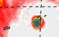
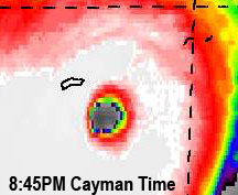
Below another image I enhanced a bit in the series 'what hit them' (see below for more). It is the first visible satellite image at 7:15AM local time at sunrise and the eye of Paloma had just passed over the Cayman Brac (the island on the right, the other little island is Little Cayman and the 'big' one, Grand Cayman). You can click on the picture to see the original (large) version and more. -Gert

GOES Visible 1km Nov.8, 7:15AM Cayman Time

Sunday, November 9, 2008 10:55AM PST - The end of Paloma
Paloma hit Cuba as a major hurricane yesterday. It is always hard to get info from Cuba, but the thing they do well is evacuating thousands of people who are in low lying areas affected by storm surge and/or flooding and mudslides. Barbara posted a AP newsrelease on the St.Maarten/St.Martin webpage, more news on news.google.com.
From the reports I have received from the Cayman Islands, Cayman Brac has suffered the most damage. As Chris, one of the great hurricane correspondents on Grand Cayman, wrote: "Paloma did to Cayman Brac what Ivan did to Grand Cayman and probably worse". If anyone knows of any specific relief efforts to help out the people on the Brac and Little Cayman let me know and I will post it. Some people are also posting on the Pleas for Help General-forum, sharing the information they have.
The good news is that Paloma is weakening rapidly, partly due to that it is still over Cuba and also because of the high wind shear. This is very good news for the Bahamas. But why couldn't we have this high wind shear 2 days ago so that the Caymans and Cuba would have been spared...? -Gert

Saturday, November 8, 2008 11:18AM PST - Cuba
Cuba here it comes... Not much to say, preparations should have been completed. The central south coast should be prepared for a significant storm surge. Below some snippets from the 1:00PM EST advisory. -Gert

     MAXIMUM SUSTAINED WINDS ARE NEAR 140 MPH...220 KM/HR...WITH HIGHER
     GUSTS.  PALOMA IS AN EXTREMELY DANGEROUS CATEGORY FOUR HURRICANE ON
     THE SAFFIR-SIMPSON SCALE.  SOME SLOW WEAKENING IS FORECAST DURING
     THE NEXT 24 HOURS...BUT PALOMA IS EXPECTED TO REMAIN A MAJOR
     HURRICANE UP UNTIL LANDFALL IN CUBA.
 
     HURRICANE FORCE WINDS EXTEND OUTWARD UP TO 25 MILES...35 KM...FROM
     THE CENTER...AND TROPICAL STORM FORCE WINDS EXTEND OUTWARD UP TO 115
     MILES...185 KM.
 
     LIFE-THREATENING STORM SURGE FLOODING OF 17 TO 23 FEET...ACCOMPANIED
     BY LARGE AND DANGEROUS BATTERING WAVES...IS EXPECTED NEAR AND TO
     THE EAST OF WHERE THE CENTER OF PALOMA MAKES LANDFALL ALONG THE
     SOUTH COAST OF CUBA.  STORM SURGE FLOODING IN THE CAYMAN ISLANDS
     WILL GRADUALLY SUBSIDE TODAY.

Saturday, November 8, 2008 08:35AM PST - What hit them...
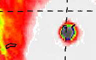
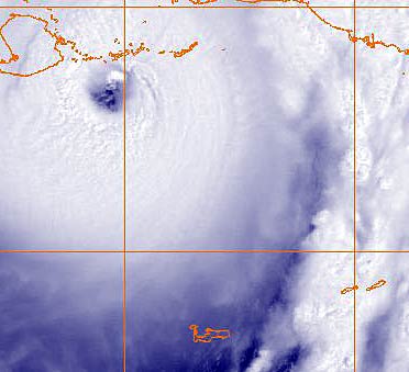
While Grand Cayman lucked out, the Sister Islands, Little Cayman and Cayman Brac didn't fare so well. After the eye just stayed off the coast of Grand Cayman, Paloma did strengthen into an extremely dangerous Category 4 hurricane with sustained winds near 135mph. Worse, the eyewall went over Little Cayman and the Brac. Below some images to illustrate what hit them. I did get one report in from Cayman Brac so far, hope to have more news soon, but it will be hard to get with power out (and no internet). I am pretty confident that everyone is ok on the islands but there will be a lot of damage. It is stressfull of course if you cannot get through to your loved ones on the islands. Be patient, stay strong and don't fear the worst. Reports as they come in can be found here. -Gert

Paloma as it passed over Little Cayman and Cayman Brac
(times are local time)
3:45AM4:45AM 5:45AM

Grand Cayman is the 'big' island bottom left, the little specs in the eye wall are Little Cayman (left)
and Cayman Brac (right). Many more high resolution satellite images can be found here.

Sat, 8 Nov 2008 11:36:18 -0400 - Big damage!

Good morning!
 
Back on Wednesday, I noted that this system would be a Cat 3 and possibly a Cat 4 due to the very favorable elements in the surrounding environments. Now, category 4 hurricane Paloma has given Grand Cayman a close call but has caused major damage to Cayman Brac and and Little Cayman. See reports from Captain Chris Taggert on the Cayman Island reports to the right on this page. Grand Cayman itself dodged a major bullet and this little jog to the ENE put the smaller islands directly in the path of the monster. The computer models grossly underestimated the potential intensity of this system yesterday and that may have led to a bit of complacency as these islands are well built to withstand hurricanes, especially after hurricane Ivan made his unwanted appearance in 2004. Fortunately, no fatalities have been reported and storm surge is not a major factor in the damage arena due to the deep waters surrounding the Caymans. Unfortunately, that will not be the case when it hits southern Cuba with the expected storm surge to be between 18-23 feet!!
 
Southern Jamaica has been pounded by rough seas and high winds from Paloma's passing as well and I'm sure there will be damage on the western and southern coasts although nothing like Caymans and soon, Cuba will receive.
 
Currently, pressure is 943 mb tying it for the second strongest hurricane in the Atlantic in November with the record held by "wrong-way" Lenny in 1999. Weakening is starting to take place as an eyewall replacement cycle is noted on satellite imagery and the weakening trend is slowly expected to continue due to expected increasing wind shear but the SST's are still very warm on it's way to Cuba so expect at least a Cat 3 at landfall. Thereafter, the mountainous terrain of Cuba, along with the shear, should take it's toll on Paloma allowing it to survive as a TS after reemerging from the coast. Then, so they say, it's supposed to fall apart as it wanders the Bahama's. Did anyone see that westerly turn at the end of the 5 day cone? Remember, 3-5 day forecasts are subject to large error possibilities. We'll see what qualities hurricane Paloma retains after it's run in the mountains.
 
Be safe!!
 
Dave

Friday, November 7, 2008 18:32PM PST - Category 3
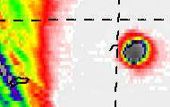
Just a short update... Paloma has been upgraded to a dangerous Category 3 storm at the 7PM EST advisory. Right now it looks like it has even strengthened more. The good news is that it is currently passing Grand Cayman just to the south and west. On the image on the right you can see the eye right next to Grand Cayman Island. The more easternly track is bad news for the Sister Islands, Cayman Brac and Little Cayman, those tiny black strips on the top right of the picture. Paloma is moving towards the north-northeast. It does look like they might get the eye, and since it is currently strengthening that doesn't bode well... Hopefully it will go more north then east. Amazingly, parts of Grand Cayman still have power and internet, so you can read live updates by the special hurricane correspondents, who are doing a great job during this stressful time. Also, check out the Paloma tools above, esp. the 'image' and 'loop'. Stay safe! -Gert

Fri, 7 Nov 2008 07:50:17 -0400 - Hurricane Paloma

Good morning!
 
Impressive, contracting, and intensifying Hurricane Paloma continues it's inexhorable dance towards the Cayman Islands with a direct hit for Grand Cayman looming this evening around 11:30 pm if it keeps it's current forward speed. Currently forecast to pass roughly 11 miles to the west, this would put the north quadrants right over Grand Cayman as a probable Category 2 storm with further intensification to a Cat 3 later. Hurricane warnings should be posted for Cuba later this morning. Hopefully, the trough digging down fronm the US will pick Paloma up quickly and speed her trek up which should lessen potential damage and flooding.
 
The good news is Haiti should miss the majority of the precipitation from this system. The bad news is central Cuba, Central and South Bahama's and the Turks/Caicos all will take another blow while continuing their resurgence from the ravages of Ike.
 
Elsewhere, where else can you talk about a blizzard in the upper mid-west and a hurricane on the same day? Still, I'd much rather have 20 foot snow drifts than the afteraffects of a Category 2 or 3 hurricane anyday. The snow will melt!
 
Dave

Thursday, November 6, 2008 19:22PM PST - Hurricane Paloma
Paloma was upgraded to a hurricane and is now packing winds near 75mph. The center is now about 150 miles from Grand Cayman and 270 miles from Jamaica. It's forecasted to go straight over Grand Cayman in about 26 hours! It will stay over 50 miles to the west of the Sister Islands. By the time it is near Grand Cayman it is expected to be a very near a Category 3 storm, packing winds of 110mph! I know it all seems kind of sudden that Cayman has to deal with a possible major storm. Final preparations should be made tomorrow morning. Jamaica is outside the 'cone of uncertainty', so should be ok. After Cayman it is Cuba's turn (again). And what is left of it then will move over the Bahamas on Monday. Stay safe! -Gert

Thursday, November 6, 2008 08:36AM PST - Paloma
Early this morning Tropical Depression Seventeen was upgraded to Tropical Storm Paloma. The center is located about 75 miles northeast of the Nicaragua/Honduras border and about 265 miles south-southwest of Grand Cayman. Unfortunately conditions are conducive for strengthening. The sea surface temperature is still quite hight, and wind shear low. Therefore it is expected that Paloma might be a Category 2 Hurricane in 48 hours.
The good news is that it is moving away from Honduras, who already had a lot of rainfall and flooding in the recent week(s). The bad news is that the center of Paloma is expected to pass very close (~20miles) by Grand Cayman in about 48 hours. People on Cayman better prepare for a major hurricane, since you never know if this thing unexpectedly strenthens into a Category 3 or more storm... Stay safe! -Gert

Wed, 5 Nov 2008 18:02:51 -0400 - TD#17

Good evening!
 
"It's not over until it's over"! Breeding in an area historically favorable for development at this time of year is TD#17, soon to become TS Palomar and eventually, Hurricane Palomar. This potentially could become a Cat 3 or even 4 storm due to high SST's, very low wind shear, and plenty of available moisture in the atmosphere.
 
Preliminary spaghetti tracks take it just south of the Cayman Islands, over the central lands of Cuba and emerging in the southern Bahama's, and Turks/Caicos by Monday afternoon as a TS. These areas are still recovering from the beatings they took earlier this year and Haiti, the winner of this years Hurricane Magnet Award, looks to take another life-threatening drenching.
 
I'll have more on this late-season storm tomorrow morning. It's moving slow now so you have time to re-prepare!!! Be safe and pay due diligence to the track of this storm.
 
Dave

Sun, 2 Nov 2008 08:45:16 -0400 - DST!

A good Sunday morning to all!
 
For those of you in most of the continental US, I did say most mind you, I hoped you enjoyed your extra hour of sleep now that Daylight Savings Time is over for another year. This transition was one week later than usual but ever fiddling congressional action was the reason. Now, I'll fall asleep before Monday Night Football gets over!
 
Wind shear has taken it's toll on the mega-blob that was in the Central Atlantic but a 1011 mb low still exists. Due to a middle to upper level ridge south of the northern islands, our conditions should remain pretty tranquil for the most part of the upcoming workweek with wind shear remaining at a high level thus negating tropical development in our neck of the woods. Most of the strongest systems on record have formed in the last 10 days of November so this is a traditionally quiet period with one last blast at the official end of season. (Nov. 30). The Weather Channel has given up the Tropical Update segment as of yesterday so our islands will get even less coverage with a month to go.
 
Off to shop and then get some rays. I haven't been in the sun for so long, I'm starting to look like I did when I lived up north! This usually happens when that 4 letter word called work takes a majority of your time. Oh well, it's better than that other 4 letter word: SNOW!
 
Dave 

Thu, 30 Oct 2008 07:18:28 -0400 - November

Good morning!
 
Hope all is well wherever you may be.
 
For a system being sheared by 20-25 knot winds, 92L has shown him/her self to be a persistent late season bloomer. Satellite pics this morning show a blowup of thunderstorm activity around 42 W but there is no QuickScat data to determine whether there is a surface low as it missed the system this morning on it's overhead pass. However, pressure is estimated at 1010 mb. 
 
Shear is expected to lessen a bit in the next say 36-48 hours which should allow for some slow intensification. There is a narrow belt of 83-85 degree water stretching from the African coast to the Caribbean which will not hurt possible development one bit. Only 56 named storms have formed since 1886 in the month of November with Hurricane "Wrong-Way Lenny" standing out during Nov. 15-19, 1999. lenny was the strongest Atlantic November hurricane on record and also was the first to officially "go backwards" from west to east. A borderline Cat 5 at one time, Lenny terrorized the eastern Caribbean much like Omar did, only worse. If this does develop, it's name will be Palomar. Sounds gender neutral to me!
 
Here in the territory there are still pockets of power outages on St. Croix and downed poles but things are cleaning and repairing rapidly. If only those complaining could see some pics that Isabel (thank you!) sent me of Hurricane Ike, they would think not twice but maybe three times before complaining. 
 
Officially for St. Thomas, rainfall for the month of October is 9.83 inches but this is measured at the airport at 12 ft above sea level. Many areas, especially the eastern end, received much more. We've been fairly dry since Omar but the potholes and mosquitoes are the size of C-130's! 
 
Dave   

Sun, 19 Oct 2008 19:09:42 -0400 - Other Islands

Good evening to all!
 
Just a quick note, Please take the time to read the posts from our other volunteer (That's right, we are ALL volunteers) correspondents on the other down islands and St. Croix. It will give you a very good idea of why I mentioned previously to not believe everything you read or hear on TV, Radio or paper at first as we have the first hand experience of what happened and the real aftermath! <ost islands had much more damage than was really reported.
 
Dave

Fri, 17 Oct 2008 15:20:29 -0400 - Aftermath Omar

Good afternoon!
 
Haven't had access to a working computer until this morning and, of course, work was primary at that time. The media reports on most of the islands are unreliable and that is one of the major reasons you have this website. From the people on the islands who went through whatever the calamity happened to be. In this case, it was a backards running Hurricane named Omar.
 
Personally, if it wasn't for an attack of the flu bug late Tuesaday night stretching into Thursday late and even a bit today, I would have weathered the storm without much ado. Shiverring, sweating, and freezing all at the same time, especially during the curfew hours, was not very pleasant. When the storm passed and I went out to survey the damage, I turned on my air-conditioer and stood by it's exhaust for it's warm discharge! A cataclysmic event for someone who always loves the cold aspect of the a/c but I just coun't get warm enough, even while sweating! I didn't even broadcast on radio or call in for TV. Anyway, that part is over and the only leftovers from Omar in my house were the usual water seepage suspects. The Towel Brigade Rules! although they are starting to get a bit raggie! Thanks to WAPA on St. Thomas, power was on for most of the night. Cable was out but I didn't care as it went out as the worst was passing by. The rest of the island saw major flooding in isolated areas, again, the usual bad drainage areas but wind damage was relegated to some trees and foliage. We even had a cruise ship today although I don't think many island tours were running.
 
St. Croix, on the other hand, continues mostly without continuous, reliable power as WAPA struggles with many downed trees and utility poles, especially on the eastern end which saw the eyewall. The highest wind gust they are reporting from St. Croix is 68 mph and that's gusts. Sorry, but it takes much more than that to bring down the amount of poles and trees on the eastern end. The main wind anemometer I believe is at the airport and they were on the western side. Several boats were lost and landslides and a good deal of flooding occurred. The COPT (Captain of the Port) in San Juan has opened some southern ports like Hovensa, the Container port, Krausse Lagoon Channel, and Cross channel are open but all others remain under Port Zulu which means all marine operations are suspended pending final port assesments from the Coast Guard. St. Croix will bounce back quickly as they are expecting a good season for Cruise Ships, something not seen in many years. The VI Government did a very good job getting ready for this event and the power crews and most of the community has pitched in to get everything back to normal much quicker than past storm events. St. Thomas even has crews working in St. Croix to help.
 
We do have some callers to local talk shows whining and complaining about not having power after 1 or 2 days but they are few. Most of us have gone 1-3 months before so a few days isn't much and if you had prepared, it would have been that much easier. Not everyone has patience and cares about others but this event proved they are in the minority.
 
Dave

Thursday, October 16, 2008 19:16PM PDT - Satellite images of Omar
I have collected some full-resolution satellite images when Omar passed through the Leeward Islands. Find them at: stormcarib.com/omar. -Gert

Thursday, October 16, 2008 07:45AM PDT - Omar
Omar raced through the Leeward Islands as a Category 3 hurricane, with sustained winds near 125 mph. It did go a bit more east then earlier thought, staying away further from the BVI and east of St.Croix but closer to Anguilla/St.Maarten/St.Martin. The closest point of approach for St.Croix was only 25 miles, for Anguilla 48 miles, for St.Maarten 50 miles, Tortola 38 miles, St.Thomas 60 miles.
Reports are slowly coming in from the islands, see list on the right side of this page. Some of the islands have no power yet, with a curfew in place so downed powerlines, etc. can be repaired. From the things I have heard there is localized damage but things will be back to normal soon. It was good that the hurricane moved so fast and didn't hang around too long to do too much damage. More later... -Gert

Wednesday, October 15, 2008 08:38AM PDT - Hurricane Omar
As forecasted Omar is now a hurricane, with maximum sustained winds near 85mph. The center is currently located about 235 miles from St.Croix. Many of the Leeward Islands are under a hurricane warning: USVI (incl. St.Thomas, St.John and St.Croix) and British Virgin Islands (incl. Tortola, Virgin Garda, Anegada, Jost van Dyke), Vieques, Culebra, St.Maarten/St.Martin, Saba, Statia, St.Barts, Anguilla, St.Kitts and Nevis.

Omar is expected to actually go over St.Croix in about 18 hours, and then pass very near Tortola and Virgin Gorda in the British Virgin Islands in 20 hours. At that time Omar is expected to be a strong Category 2 Hurricane with 100mph winds. Looking at the satellite images I would not be surprised if it would be possbily a Category 3 hurricane by that time (winds over 110mph), which is serious. Also, Omar is expected to produce lots of rainfall, not only in the USVI and BVI, but also Puerto Rico, Anguilla, St.Maarten/St.Martin... These rains might actually be the biggest threat, since the ground is already saturated with water on many of the islands due to all the rain over the last week...

Below I have listed the closest point of approach for a number of islands. As we all know there is uncertainty in the forecast so keep check out the 3 day cone and other tools above. Also, a hurricane is not a point, in about 1 day hurricane winds are expected to extend outward from the center at about 25 miles, tropical force winds about 140 miles, with the strongest winds on the eastern side (actually away from the USVI). The CPA times listed below (sorted by distance) is regarding the center of the storm, not when tropical storm or hurricane force winds start to blow, which will precede the storm by hours. Take this storm serious! Let's just hope that this storm more or less follows the forecast, doesn't do unexpected strengthening or stalls somewhere... Stay safe everyone! (I am still busy at work, but will try to update later.) -Gert

                           cpa
Island/Town              mi    km  hours
Tortola:                 5.7   9.2  20.6  (Thursday, Octover 16 at 7:36AM EDT)
St.Croix:               11.5  18.5  17.8  (Thursday, Octover 16 at 4:48AM EDT)
St.John:                12.0  19.3  19.9  (Thursday, Octover 16 at 6:54AM EDT)
St.Thomas:              24.2  39.0  19.3  (Thursday, Octover 16 at 6:18AM EDT)
Anguilla:               80.3 129.2  23.1  (Thursday, Octover 16 at 10:06AM EDT)
San Juan, Puerto Rico:  82.5 132.8  17.4  (Thursday, Octover 16 at 4:24AM EDT)
St.Maarten/St.Martin:   84.5 136.0  22.6  (Thursday, Octover 16 at 9:36AM EDT)
St.Barths:             104.9 168.8  22.7  (Thursday, Octover 16 at 9:42AM EDT)
St.Eustatius:          115.8 186.4  21.2  (Thursday, Octover 16 at 8:12AM EDT)
Mayaguez, Puerto Rico: 135.3 217.7  14.3  (Thursday, Octover 16 at 1:18AM EDT)
St.Kitts:              139.0 223.8  21.3  (Thursday, Octover 16 at 8:18AM EDT)
Antigua:               193.6 311.5  22.8  (Thursday, Octover 16 at 9:48AM EDT)

Tue, 14 Oct 2008 23:39:30 -0400 - Omar!

Good evening!
 
I warned about complacency (?) previously and now, I see almost a panic response tonight with gas stations being overrun and the supermarkets parking lots totally packed. Hmmm.
 
News reports from the mainland have really only mentioned Puerto Rico which is one of the reasons I started to write for this site in the first place as we are, after all, a part of the United States and it irritates me to no end that we are virtually never mentioned when storm events occur. Just a speed bump on the road to PR and the mainland. Mike Seidel of TWC is on Puerto Rico from what I saw broadcast earlier. Does anybody wonder why TWC doesn't send anyone here to the USVI? It's because, I reason, that they have no way to evacuate if it really does hit! Imagine trying to fly out of Cyril E King airport right before a storm because you are a journalist on the run. Sorry I don't feel bad on this but I live here and have been a weatherman on TV for 6 years and would really like to see someone actually report from th US Virgin Islands.
 
Since that is not going to happen, that's why you have me and a few other outstanding people reporting, giving you the SP! My generator is ready, where I work is prepared, but I am worried about the island in general due to the previously briefly mentioned complacency issue not to mention the saturated grounds we have already.
 
The COPT (Captain of the Port) who is the head US Coast Guard person based in San Juan, Puerto Rico, and responsible for the US Virgin Islands waters has closed the harbor. Please see attached which I don't normally do.
 
The eye, as a Cat 2, is forecast to pass a mere 13.9 miles from St. John in about 30 hours which places it above where I live as the eyewall is about 20 NM wide and I live across from Pillsbury Sound at about 600 ft 4 miles away. Not good! Will write when possible and will probably do some radio updates until WAPA chokes!
 
Dave

YANKEE MSIB-1.pdf

Tuesday, October 14, 2008 14:07PM PDT - Omar, TS 16, two invests
It sure looks more like September with all this activity! Omar looks pretty big in the Caribbean Sea, affecting a lot of the islands, judging from all the reports I am getting in from the special hurricane correspondents.
Sorry, I have to keep it a bit short since I am quite busy at work at the moment and haven't had time to look over all the weather data and satellite images. Omar has been drifting a bit to the southeast instead of to the northeast, therefore its forecasted track has shifted more to the east. Omar is now expected to pass in between the BVI/USVI and Anguilla/St.Maarten. Since it is moving so slow it is a bit unpredictable, and looking at the size, everyone in that region should be expected massive amounts of rain. Also, Omar might actually be a category-2 hurricane by the time it crosses the island chain. I still don't think that this will become a dangerous category-4 or even 5 hurricane (like Lefty Lenny in 1999), but it might become a category-3 storm. So take this storm serious, slow moving storms are always more dangerous because of high rainfall accumulations, and since it might be a category-2 storm, possibly higher, you have to wind proof your house. It's always better to be over-prepared! -Gert

Mon, 13 Oct 2008 20:04:50 -0400 - Just an update

Good evening!
 
My trek home earlier took about an 1 1/2 hours and I only have to drive 10 miles on a 13 mile long island! One route was totally flooded which was the Havensight route (a merger of Lake Turnbull and Lake Havensite) was occurring and the Brookman Road decided to grow a tree in the middle of it! So, a various route was undertaken through Smith Bay and Red Hook. Not fun!
 
TD#15 has grown immensely today and looks to bring OMG amounts of rainfall to all of the Northern Islands as computer models are still very consistent with their northeast track. St. Croix is taking the brunt of the early rainfall as I write this but that will change tomorrow unless all of those models are wrong. My towel brigade was briefly overrun at home but made a nice counter attack shortly afterwards but I'm not sure how long that will last as the rain came down so very hard in a short time span. WAPA, to their credit (Our electric company) stayed on the whole time! Go figure! More menana!!
 
Dave

Mon, 13 Oct 2008 14:23:46 -0400 - PREPOSTEROUS!

CCKKKKKKK!!!! Houston, we have a problem!!!!
 
For my last few post's, I have been warning about complacency and taken some ribbing for it but, what do we have now? Another late season contender to the 2008 hurricane throne!
 
Potential Hurricane Omar (no, not the tent-maker!) is growing in the southern Caribbean, the spawn of an older storm years ago named "Wrong-Way Lenny!" Most of the computer models are projecting a path over Eastern Puerto Rico, Viques, Culebra, and the Virgin Islands. Not good. We are still saturated from the rains of a few weeks ago with landslides and flooding a monster probability. Puerto Rico's southern rivers are at shallow depths so flooding can occur with extreme rapidity while the volcanic nature of St. Thomas means little soil to soak up more rains. St. Croix has a wider, flatter area but drainage has always been an issue their so flooding will be a huge problem.
 
Right now, it is raining so hard, I cannot see the mountain less than a half-mile away. I knew I should have left my water pump on which drains one cistern into the other so my living room doesn't flood. Oh well, the joys of living in Paradise! At least I have gas for my generator!
 
The 5 pm tonight and the 5 am Tuesday report will be of utmost importance to all in the way of this developing system. As big as it is, and slow as it is, copious amounts of rain will fall over a wide area so landslides and flooding are almost inevitable. Once again, the preposterous has happened. A backwards storm!

Monday, October 13, 2008 09:04AM PDT - Number Fifteen
The tropical wave I mentioned yesterday (Invest 98L) has just been upgraded to a tropical depression. The center is currently located about 340 miles southwest of San Juan, PR and about 175 miles north of Curacao. It is not moving much but it is expected to pick up some speed tomorrow or so. It will likely be upgraded to a tropical storm (Omar) by then as well. The storm is expected to move to the north-east and cross the islands around the east coast of Puerto Rico. Although similar in direction as 'Lefty Lenny' back in 1999, it will by far not be as powerful and I don't expect too many problems. I am glad that it doesn't seem to threathen Haiti/Dominican Republic anymore.
Meanwhile, Nana weakened to a depression and there is a new invest (99L) off Nicaragua. This system has a medium chance to develop into something. Quite some activity this week! -Gert

Sunday, October 12, 2008 15:24PM PDT - Nana
Invest 97L becomes the fourteenth tropical storm of the season formed in the eastern Atlantic, about 1500 miles east of the islands. Pretty unusual for this time of the year. It is expected to weaken again soon. So no worries for the islands. There is however a strong tropical wave passing through the islands (Invest 98L). It is expected to move towards Hispaniola. Hopefully it won't cause too much flooding again over there. -Gert

Sat, 11 Oct 2008 12:13:28 -0400 - Shake, Rattle, and Roll!

Good morning to all!
 
A rather uneventful, in the Atlantic basin anyway, period came to an abrupt halt this morning with a magnitude 6.1 earthquake at a 16 mile depth about 69 miles NE of St. Thomas at the ripe time of 6:40 this morning. Minor damage has bee reported but I did not see any on my way to work this morning. Haven't heard much from PR or the BVI's yet but I know it made the morning news reports on the mainland US as my Mom called me to ask if I was ok and she lives in way upstate NY!
 
With the historical rainy season upon us, a look at the Christmas tree lit up satellite pic reveals history is right, at least for the upcoming week. We have a tropical wave getting it's you know what kicked by wind shear but it still contains a 1009 mb low. Farther east, Invest 97 is a disorganized train wreck at the moment but should still make tropical depression status in 2-4 days. Most of the computer models have it travelling north of the islands as the low just to our east is forecast to go over Puerto Rico and pull the invest with it. What that low just to our east will also do is dump copious amounts of rain on the Northern Islands which will cause a recurrence of flooding experienced just a few weeks ago, especially in Puerto Rico.
 
With 7 weeks left in the 2008 hurricane season, officially, a sense of complacency has descended on most of the Caribbean as nobody I've talked to believes we will see anything else develop and threaten the islands. Not good.
 
Have a great and safe holiday weekend!
 
Dave

Tue, 7 Oct 2008 07:40:12 -0400 - Marco who?

Good morning to all!
 
A red rubber ball greeted me as I stepped outside to survey the morning's offering's which appeared to be a better start to the day than yesterday's Manic Monday (of Bangles fame). With it also came a Tropical Storm named Marco in the Bay of Campeche which happens to be the smallest TS I have ever witnessed. I don't know if the NHC was bored by the lack of activity lately but it does fit the criteria although I could have said the same for an unborn at that time Fay when she was meandering over the territory. However, the fact remains that in a 5 hour period, this went from nothing to a 65 mph Tropical Storm and could even make Cat 1 status before landing.
 
Marco's winds stretch a mere 15-20 miles out from center and if you were a regular Joe or Joey looking at the weather map, you wouldn't even know it had a name. Now Norbert, a hurricane, would stick out in the East Pac and Norbert is expected to curve into the sparsely populated Baja.
 
Our neck of the woods continues to be protected by wind shear which is currently beating up on a wave along 38W so any development will be a long time coming if at all. African dust is inhibiting another wave behind it around 20W but either one of them can still spin up and pull a 5 hour Marco.
 
Mosquito fogging is scheduled to start this week and you'd be surprised at how many people are against it. I guess they've never breathed in any of the Raid they've been spraying or experienced Dengue fever. Bring on the mist!
 
Dave 

Monday, October 6, 2008 10:08AM PDT - Number Thirteen
A new tropical depression formed in the Bay of Campeche (southwestern Gulf of Mexico). It is moving towards the Mexican coast where it is expected to make landfall tonight or early tomorrow. It might just reach tropical storm status and be named Marco before making landfall but it shouldn't become a hurricane. No threat to the islands. -Gert

Monday, September 29, 2008 08:40AM PDT - Laura
I was a bit surprised to see this morning that there was another named storm. Luckily it is far away from the Caribbean in the northern Atlantic. No worries for us, not even Bermuda. Another one down. The twelfth storm of the season. How many more to go? -Gert

Sat, 27 Sep 2008 08:38:51 -0400 - Quiet for now but Taiwan Ouch!

Good morning!
 
With the exception of a very determined, yet still under wind shear assault Kyle, the Atlantic basin is fairly quiet. One disturbance which has been followed for a few days is expected to be destroyed over the next two days or so by increasing wind shear so no threat exists at the moment from this.
 
The Yucatan peninsula will be under the rain gun this weekend as a disturbance moves ashore, probably just in time to avoid tropical depression status. It remains to be seen after it emerges into the GOM whether it will develop and become a threat to probably Florida at this time with the advent of an approaching cold front.
 
If you want to witness raw power and incredible amounts of rain (and your not in Haiti or the DR), check out Super Typhoon Jangmi in the Western Pacific which is about to deal a royal flush to the island of Taiwan continuing on to mainland China. Sustained winds are 155 mph with gusts to 190!!! Preparations for this are: Run Forrest, Run! The mountainous terrain of Taiwan bode ill for those on the slopes and also at the bottoms of these mountains plus the combinaion of high winds and storm surge will be a devastating 1-2 punch along the coastline. It is forecast to drop to a Cat 3 by landfall but it's a massive system and a drop to Cat 3 will not bring much comfort.
 
Have a safe and fun weekend!
 
Dave
 

Thursday, September 25, 2008 14:22PM PDT - Kyle
Finally the Invest we have been monitoring for days, and has caused a lot of flooding on Puerto Rico has been upgraded to tropical storm Kyle. Luckily it is already north of the islands and moving further north, so it shouldn't affect Hispaniola too much if at all. That is especially good news for Haiti, who is still recovering from the flooding of other storms. The forecast has it also move away from the Turks and Caicos and the Bahamas. Only Bermuda will have to keep an eye on this one, esp. since it might strengthen into a hurricane later, but so far it looks like it will stay a safe distance from Bermuda. Right now the closest point of approach for Bermuda is 250 miles in about 40 hours. -Gert

Wed, 24 Sep 2008 07:58:01 -0400 - Finally!

Good morning!
 
With a brilliant flash of light and an incredible crack of thunder, I found myself slowly peeling away from the ceiling in my bedroom like wet Scott tissue around 11:50 pm last night, marveling that I didn't impale myself on the ceiling fan slightly to the left of dead center of my bed. With that Godly pronouncement, a torrential downpour ensued which lasted approxiamately 45 minutes forcing power to go off briefly and panic on my part as I had already put the towel brigade back to rest and cleaned the wet-vac. Oh well, back out they came and order was restored around an hour later. The leaks had been conquered once again!
 
Awakening to make my daily trek to work, I discovered something I hadn't seen since Friday: a sunrise complete with sun! What a concept! And while a few passing cumulous clouds floated by with grey/black coloring, it apeared the day would start rain free. What I didn't expect so soon was the ambush which awaited me just outside my door: a small platoon of small mosquitoes hungrily eyeing me through my front screen. Arming myself with Raid, I proceeded to wipe out the vanguard of what is sure to be a major invasion of these no-good-reason-to-be-on earth pests. With that, I started my real morning by making the dangerous trek from my place to work as some people think it's ok to drive really fast through potholes and ponded water while striving to drive in your lane and not theirs.
 
Having pretty much been torn apart by wind shear, the system that lingers should hopefully restart it's sluggish engine and move north northwest but plenty of moisture and convection will follow and continue to bring sporadic heavy rainfall to Hispaniola and other nearby nations. Off to the east, we have a couple of waves but nothing significant while the African continent has a few waves lined up.
 
Still, while it's quiet now, September is not over so all systems should be watched with interest. Happy hump day!
 
Dave


Sun, 21 Sep 2008 11:27:38 -0400 - Wet!

Good morning and a quick post before I lose internet again.
 
93L is slowly getting it's act together with some rotation and consolidation. Heavy rains have been pounding St. Croix for over an hour now with St. Thomas/St. John, the BVI's and the eastern end of PR including Culebra and Vieques starting to take blows as well with no end in sight for the next few hours. Flash flood watches are up and 93L will probably be declared a TD by as early as tonight but probably tomorrow as aircraft reconnaissance will be assessing the situation later today. If they do not find a closed center of circulation but they do in the middle levels, it will not be declared a depression but it will be eerily similar to Fay's development earlier this season by breeding right over us. Wind shear is still an inhibiting factor but is expected to lessen a bit thereby allowing slow strengthening.
 
By the radar appearances and projections, I believe "Wet-Vac" Man is going to make an appearance later today as will "Water Pump Mon!" We can always use the water as it's expensive to buy (USD525 for a 5200 gallon truckload) but this is evidence of too much of a good thing. Then, after we start to dry out, the mosquito population explodes with the fast little ones and eventually the helicoptor variety. Ah, paradise!
 
Where it (Kyle?) will go down the road is a tricky forecast and I haven't spent much time trying to analyze it's potential path yet but anywhere over the DR, Haiti, Bahama's and Turks/Caicos is not good even if it doesn't develop.
 
We also have a small "blobbette" over by the coast of Africa to watch for the next few days as development is possible but should be slow. It's still September and we must remember!
 
Dave


Fri, 19 Sep 2008 07:37:33 -0400 - 93L

Good morning!
 
The 'exploding blob" of yesterday failed to manifest itself across the territory with any vigor last night with but a few showers falling as it took a step back to regroup. Now, due to the upper level low which had been creating strong wind shear conditions over the top of this system slowly retreating back to the north/northwest, more interest in the possible development of this system has arisen, hence 93L. Mid 80's water temperatures, diminishing shear, and a very moist atmosphere is a recipe for development and we will probably see Kyle mid week next. Preliminary projections, and that is just what they are, have a potential path leading to already hurricane ravaged areas. Meanwhile, active weather is expected to continue over the Windwards with the northern islands supposed to get in on the action over the weekend.
 
The eastern frontier looks quiet with the next unimpressive wave about to depart the African coast. We have already seen and experienced how quickly these systems can spin up and we are still in the heart of hurricane season so attention must remain at a high level. Computer models project formation next week in the hurricane belt as well. Looks like the lull might be over unfortunately.
 
Have a fun and safe weekend!
 
Dave

Thu, 18 Sep 2008 07:50:51 -0400 - Exploding Blob!

Good morning!
 
While Texas, Louisiana, and the Caribbean nations struggle to cope with the trail of destruction left by Hurricane Ike, the Atlantic Basis is quiet for now. Anew wave passed off the coast of Africa but at the moment doesn't seem too impressive. There are a few more on the continent itself that are impressive and bear monitoring down the road. What is also impressive is the "exploding blob" off to the immediate east of the Windwards. If that upper level trough (or TUTT) hadn't been in the position it is, stretched over Puerto Rico and into the Central Caribbean, we very well could have had our next storm. The trough is expected to lift to the north after the weekend which means, combined with the approaching tropical wave, more wet and active weather here in the Eastern Caribbean. The TUTT's southwest flow, other than providing shearing protection, is bringing up more warm moisture from the equatorial zone further adding to the destabilization of the atmosphere. The local weather forecast says 60% today. I think it's more in the range of 100%, especially after noon and this evening. I know more than a few visitors who aren't very happy with that but our cisterns are!
 
Dave

Tuesday, September 16, 2008 08:16AM PDT - Nothing?
No active tropical systems and no invests today. That seems so long ago that we didn't have anything to keep track off! Good news of course. Let's not forget though that some of the islands got pretty badly hit by Ike and they still need your support. Especially: Haiti, Turks&Caicos (esp. Grand Turk, South Caicos and Salt Cay), Inagua (Bahamas) and Cuba. Esp. the situation in Haiti is pretty sad. See the latest OCHA (United Nations Office for the Coordiantion of Humanitarian Affairs) Situation Report on the reliefweb.int website. Glad to see there is a little more media attention, now that Haiti born Wyclef Jean and Matt Damon visited Gonaives.

Sun, 14 Sep 2008 10:47:55 -0400 - Evacuations

Good morning!
 
I was enlightened this morning by a reader who informed me Texas law, even if a mandatory evac order is issued, does not require people to leave their homes. Why say the word mandatory when it has no teeth? He also provided me with a link to the Houston Chronicle concerning those who failed to heed these orders and warnings like in Galveston and the Bolivar Peninsula. I agree with one reader; anyone who didn't leave under mandatory evac orders and subjected a child to Ike's fury should be charged with child abuse and/or endangerment. If there's no teeth in one law, there should be in this one.
 
The link is:
http://www.chron.com/disp/story.mpl/hotstories/5999238.html
 
Thanks Doug!
 
Locally, it has rained for several weeks each day; some, more than others. The sun is shining for the moment but it looks like we will see more showers and isolated T-storms the next few days. Next weekend looks to be dry right now.
 
Moving on to east of the Caribbean, a few waves are still on their journey from across the pond but show little in the way of development as wind shear and dry air to the north is just too much right now. However, after this 28 day burst of activity, it's time to catch our collective breaths as their is more ahead. Don't let the lull fool you; rather let it strengthen your resolve to be prepared!
 
Have a great and safe rest of the weekend!
 
Dave
 

Sat, 13 Sep 2008 10:16:53 -0400 - Ike and others

Good morning!
 
Hurricane Ike continues to traumatize and terrorize Texas and parts of Louisiana this morning as it has started to speed up on it's way to Chicago and the northeast over the 2nd half of the weekend. It can't move fast enough for those in affected areas and maybe, just maybe, those idiots who stayed when told to evacuate will think twice the next time. Yes, there will be a next time. It's inevitable. Maybe not next year, or the year after or even next decade but it will. They are putting the lives of many brave rescuers in danger by their selfishness. Cuba sets a good example when they call for mandatory evacuations. They make an example out of those who ignored orders to evacuate and wound up needing to be rescued. I'm not advocating we do what they do as punishment but maybe we should charge these reckless people who fall into the selfish category for at least the cost of their rescue and fine them. One life lost is too many, whether it is a rescuer or a stupid person. Shouldn't mandatory mean mandatory?
 
While 95% of eyes are on Ike, relief efforts continue in Haiti, Southern Bahama's and Turks&Caicos. I haven't heard much news from Haiti but I'm sure it's very grim. T&C seems to have their act together with a huge team effort and plenty of selflessness.
 
Off to the east, the second half of a very active 2008 hurricane season has begun. Not much to talk about with 91L expected to go through the Bahama's maybe making Tropical Storm status on the way but wind shear is this systems mortal enemy. A few other waves are making the trek but not much promise is being shown and we don't want any! Another wave should exit the african coast in the next 3-4 days and that does show promise.
 
Locally, we have had our share of rain the last two weeks with emerald green fauna, muddy roads, and hordes of mosquitoes bringing the possibility of dengue fever which is a form of malaria transmitted by these pests. It ranges in severity and can even cause death in infants and older folks so mitigation is a necessity in the tropics. Spraying, fogging, and emptying all standing water help with it's control.
 
Dave

Friday, September 12, 2008 13:04PM PDT - Get out!
I have been reading some news articles on-line and have to get this off my chest. A plea of urgency to people living near the coast in Ike's path: Get out! Don't be stubborn (read stupid) and think that you can toughen it out. Especially in Galveston and Port Arthur. Don't think it is just a Category 2 storm. The danger is not in the wind but in the storm surge that can overtop the seawall by several feet, flooding the whole city. When you live on a tiny Caribbean island there is an excuse of staying put (you'll have to fly out, and there are not enough planes to evacuate a whole island). But for you in Texas you can just hop in your car and drive north! Don't be stupid and just go! You are not becoming a 'hero' because you 'survived' Ike. Read also Jeff Master's blog on Wunderground.com if you don't believe me. Ike is a huge storm, take it seriously. Just go! -Gert

Wed, 10 Sep 2008 16:57:17 -0400 - September 10th

Good afternoon!
 
Not much to dwell on at the moment as Hurricane Ike creeps towards the Texas coast with killer storm surge thoughts. Just where exactly it will hit is still in the air but everyone along the coast of Texas and southwestern Louisiana had better be finished with preparations by Friday late morning. There will be no "White Knight" in the area to ride to the rescue once this monster hits.
 
It's great to see the outpouring of support for the populace of Haiti and the T&C islands. Please help if you can and follow the instructions as to how to give supplies or money to ensure it gets where it's needed most. The British Red Cross for the T&A and the Lambi Fund for Haiti are already there and working hard to assist and aid in the recovery of both nations. While both are devastated, Haiti is way worse off with the terrible flooding. I know you all join me in praying the "hurricane magnet" of this years season doesn't suffer again.
 
The remnants of Josephine is trying to resurrect the old gal with convection flaring up on her northern end and a little on her southern end. Parts of that convection came through here again last night and I bet Mother nature beat God at celestial bowling (Maybe us earthlings could donate a Wii to them) as the lightning and rain was more intense than the night before. Fortunately, today was drier but those Josephine fragments might bring us more in a few days.
 
Off to the east, a few waves are weaving their way westward but none are organizing at the moment. Another wave is about to exit the African coast and there are a couple more lined up behind.
 
Today is the historical peak of the hurricane season and we have already seen and many experienced the wrath the first half has provided. It's not over yet. There IS a second half to this show.
 
Dave

Tuesday, September 9, 2008 18:17PM PDT - Haiti, Part 2
Just to illustrate the fact a bit more that Haiti needs your help, watch this 3:45 minute YouTube video clip, which was put earlier on the Haiti-webpage by one of our correspondents. It shows what Gustav and Hanna (Ike came even later) did to the town of Jacmel, where the Hands and Feet Project has an orphanage. They need donations. Other good places to donate are Lambi Fund of Haiti and British Red Cross Hurricane Appeal. -Gert

Tuesday, September 9, 2008 09:07AM PDT - Donate!
Finally some time to write a little entry... After popping out on the southern side of Cuba the center of Ike made landfall again in western Cuba (the same area that got hit by Gustav this year). Read some of the news stories on news.google.com. Since it was over land for awhile Ike has weakened significantly but it is still packing 80 mph sustained winds. After it crosses Cuba it is expected to strengthen again over the warm waters of the Gulf of Mexico. Right now it is expected to make landfall Saturday morning as a Category 3 (extensive) hurricane near Corpus Christi, Texas. However, the 'cone of uncertainty' (see above) is quite large.
Since Ike passed pretty close to Haiti they felt the effects as well. Just what they needed on top of Hanna. The situation in the Gonaives area is still horrible. Aid is hard to get to the affected area since most of the roads are still impassible. Right now the death toll is at 331 and expected to rise. Read some of the heart breaking news stories on news.google.com. The British Red Cross has a special fund for Hurricane Relief. I haven't found links to specific Caribbean Hurricane Funds on the American Red Cross or International Federation of Red Cross. Jeff Masters who writes an excellent hurricane blog on wunderground.com mentioned the Lambi Fund of Haiti. He wrote: "The charity seeks not just to provide much needed temporary food aid, but to make investments in sustainable development in an effort to restore environmental integrity and reduce poverty. One of the main places my donations have gone is to fund the purchase and planting of thousands of trees on Haiti's denuded mountainsides. These treeless slopes, missing more than 98% of their original forest cover, allow flood waters from hurricanes to rush down and cause the mind-numbing loss of life we've grown to expect with each hurricane that affects Haiti. If you're looking to help out in the country in the Western Hemisphere that needs the most help, consider a donation to the Lambi Fund." On the Turks and Caicos-webpage there are also a couple relief effort mentioned to help the people on Grand Turk, South Caicos and Salt Cay. -Gert

Mon, 8 Sep 2008 17:39:25 -0400 - Waiting and wondering

Good evening!
 
I am trying to get this in before the next bunch of thunderstorms roll in, courtesy of a tropical wave trying to ride Ike's coattails. Flash flood watches are up for the USVI's and Puerto Rico where it has been raining most of the day. Looks to be an active night as a line of thunderstorms are already over the western end of St.Thomas with a good size blob about to hammer St. Croix. Keep those flashlights close by!
 
Sporadic reports of immense damage continue to roll in from the T&C and Cuba. Some have been confirmed and others not, so believe but on the side of caution until these reports are confirmed. Please check the T&C post for more details about where to send donations of dinero and/or relief supplies. These people need your help! Ike will no doubt be on the retired list of storms when his rampage is done. Currently a borderline Category 1 hurricane, Ike is expected to gain a little strength as he meanders close to the southern Cuban coast on his way to a meeting with the Gulf of Mexico and a possible date with Miss Texas. Nothing in stone is written yet though as Ike could still decide after visiting Castro to pull a fast one and sneak farther up the coast to Louisianna. Alot depends on speed and a high pressure area way up ahead. Tuesday night we should have a much better idea of Ike's intentions. None of them are any good though!
 
This wave's intentions aren't good either as heavy rains have fallen on saturated grounds over the Northern Leewards . If you are complaining about your cistern not being full now, plug the downspouts in! A good night to stay home and watch tennis or football if the power AND cable stay on. Way to go Serena!
 
Josephine is still making an appearance but she is looking like an old sea hag at the moment. She could however receive a shot of botox in a few days and rejuvenate but she's starting to lose her grip. 
 
The coast of Africa just got interesting as well with a strong wave coming off as this is typed. High up though and looks like the Cape Verde's will be in for a good jolt tomorrow. Plenty of Saharan Dust also in that area to hamper any development.
 
Sending this now as it's raining lions and tigers and bears! AAANNNGGHH!!! Too late! Thank you for playing! I'll send as soon as this allows me to reconnect. Be safe!
 
Dave 

Sun, 7 Sep 2008 18:27:51 -0400 - Video

Good afternoon!
 
A real short message. Please check out the video sites listed by our contributors from the Turks/Caicos. I just watched plenty and it is unreal. Brings back goosebumps of Marilyn (1995). There is also some footage from Haiti which is almost indescribable and extremely sad. Hope all who are in a position to help, help!
 
Dave

Sunday, September 7, 2008 09:58AM PDT - Ike
A short message... a bit too busy... Ike passed over the TCI last night. First reports indicate that Provo did ok, even phones are working (but overloaded). Grand Turk on the other hand didn't fare too well. There is significant housing damage, but not as bad as some US TV channels are indicating that that Grand Turk is 'destroyed'. I will share any information I get and post/reroute it on the Turks and Caicos webpage. Other hurricane correspondents are contributing frequent updates, esp. Jeff is keeping us well informed. Hope to get some info from some of the other smaller islands, like Ambergris Cay. You can also share information/post pleas for help on the bulletin board. Meanwhile the eye of Ike passed straight over Inagua (Bahamas) and will hopefully get some reports later. I have been collecting some high resolution satellite images when Ike moved over the TCI, find them here. -Gert

Saturday, September 6, 2008 20:18PM PDT - Pleas for Help Board
A little early for this, but I have a 'Pleas for Help' forum where people can exchange information. In the past it has proven to be a great medium for connecting people watching this storm off-island. It feels a lot better when you are in contact with people who are in exactly the same stressful stituation as you are... Find it at: help.stormcarib.com. I will create a dedicated TCI forum if the need is there, hopefully not. If you are confused with where exactly is Provo (Providenciales officially), Grand Turk, ... there is a really nice map on Wikipedia. Hoping for the best... -Gert

Saturday, September 6, 2008 14:03PM PDT - Cat 4
Ike is about to bear down on the Turks and Caicos Islands (TCI) and just now Ike has been upgraded to a Category Four (Extreme) Hurricane... Sustained winds are now 135mph! The only good thing is that it is moving relatively fast at 15mph so it won't hang around like Hanna did. So far it looks like these islands won't get the eye, but it will be close. On the other hand, Inagua (Bahamas, that 'big island southwest of TCI', see map of Bahamas) will get the eye. Wikipedia tells me that the population of Great Inagua is 969, with the capital Mattew Town in the southwestern part of the island. Hope we hear some good news from our hurricane correspondents on the TCI and Bahamas soon after the storm has passed... Further ahead..., Ike goes more way more south then earlier forecasted, with the eye passing over almost the full lenght of Cuba. That should weaken Ike a lot, but when it comes over the ocean again it will quickly strengthen. The good news is that it looks like now Ike's eye should stay over 100 miles away from the Florida Keys. Use the tools above to calculate how far it is or how close it can get. Stay safe! -Gert

Sat, 6 Sep 2008 10:39:48 -0400 - Yikes for Ike!

Good morning!
 
The treadmill of the 2008 hurricane season just keeps running on with TS Hanna trying to escape a fast closing hurricane Ike and poor TS Josephine lagging far behind but still showing some promise this morning. Meanwhile, another contender is exiting the African coast.
 
The African continent, which has rapidly been firing salvos for the last few weeks, appears to have temporarily run out of ammunition after this last wave exits today. Firing blanks is not a bad thing, in this case! Satellite imagery indicates a lack of strong wave action until you reach over halfway across so a lull at the starting line is anticipated but won't last long.
 
TS Josephine is no quitter but has been taking blows right and left. A bit more impressive this morning on satellite imagery, she still stands the chance of being torn apart but Bermudians should still pay attention as she moves WNW.  
 
TS Hanna is honking up the east coast and now DC and NYC will get a taste of what we have to deal with here in the Caribbean as they are all likely to feel Hanna's TS force winds due to her forward speed around 22 mph. While the rains have been beneficial to Georgia and the Carolina's, the storm surge expected from Hanna along the northeast coast will not be.
 
Hurricane Ike. Once again, another system proving forecasting as an inexact science. Wind shear has taken it's toll but Ike is still a formidable storm and once the wind shear relaxes after the weekend is over, Ike will likely resurrect himself to his former major hurricane status. This will be a proverbial caged lion once in the Gulf of Mexico as there is no way out but over land and probably in areas already affected this year.
 
Of more immediate concern is Ike's potential impacts on the Bahama's, Turks and Caicos, the DR and Haiti. The giant island of twin nations Haiti and the Dominican Republic ARE this years hurricane magnets! While the fatality count is officially below 200, there are many more, especially in Haiti with Ike about to provide a nasty blow to the chin of an already glass-chinned opponent. Please pray for these people as many do not have anything left already but their lives from Hanna's and Gustav's earlier attacks.
 
Cuba and the Florida Keys are next with the mountains of Cuba to have a significant impact on Ike's strength but the Keys are expected to take a strong blow from Ike with storm surge and wind damage probably highest in the upper Keys due to Ike's proximity. Still, all of the Keys are under mandatory evac orders as Ike has deadly potential there as well.
 
Once in the Gulf. it's Texas or Florida as it stands now. Where exactly is very important but whats' more important is that you are prepared.
 
Stay safe!
 
Dave


Friday, September 5, 2008 08:43AM PDT - We don't like Ike
Unfortunately, as forecasted, Ike has indeed started to move a bit more south of due west... Actually, the current forecast takes Ike even more south then earlier. It might even sneak in between Cuba and Florida, although that is still very uncertain because it is so far away... In any cast, the Turks and Caicos and southern Bahamas should prepare for a direct hit by a major hurricane! Although Ike has weakened a bit; the eye has almost disappeared on satellite imagery due to wind shear, conditions should become more favorable again for strengthening. Not good. I hate to have to do this again, but below I listed the Closest Point of Approach (CPA) for many of the islands in its path. Note that I don't include Florida, except Key West. I have however listed latitude/longitude info on many cities in Florida so you can calculate the CPA yourself, as it looks right now it is expected to pass very close by Miami. Also, check out the other 'Ike tools' options like the uncertainty cone, and model spaghetti plots (new feature, see below, all these are pop-ups, and can be closed quickly by clicking anywhere on the image). Don't focus on the track alone, a hurricane is not a point and forecasts beyond 3 days out are prone to large error. At least Josephine is getting weaker and we don't really have to worry about that one anymore.
Finally, let's not forget what is going on in Haiti. Unfortunately I don't have too many hurricane contacts in Haiti, but it is very sad if you read the news stories. The death toll now is at 136, but expected to rise. It is very hard to get food and water to the people affected. "Large areas of Gonaives were still deluged by floodwater on Friday and up to 70 per cent of its 300,000 residents have been without water or food since the storm hit on Monday." Not good. -Gert

                           cpa
Island/Town              mi    km  hours
Provo, TCI:             28.9  46.5  46.9 (Sunday, September 7 at 9:54AM EDT)
Key West, USA:          35.9  57.8 112.1 (Wednesday, September 10 at 3:06AM EDT)
South Caicos, TCI:      47.5  76.4  43.5 (Sunday, September 7 at 6:30AM EDT)
Exuma, Bahamas:         48.6  78.2  66.2 (Monday, September 8 at 5:12AM EDT)
Grand Turk, TCI:        50.2  80.8  41.7 (Sunday, September 7 at 4:42AM EDT)
Inagua, Bahamas:        98.7 158.8  52.8 (Sunday, September 7 at 3:48PM EDT)
Cat Island, Bahamas:   100.2 161.3  64.8 (Monday, September 8 at 3:48AM EDT)
San Salvador, Bahamas: 100.6 161.9  60.4 (Sunday, September 7 at 11:24PM EDT)
Bimini, Bahamas:       119.8 192.8 102.3 (Tuesday, September 9 at 5:18PM EDT)
Nassau, Bahamas:       122.5 197.1  81.1 (Monday, September 8 at 8:06PM EDT)
Habana, Cuba:          150.4 242.1 106.8 (Tuesday, September 9 at 9:48PM EDT)
Eleuthera, Bahamas:    156.4 251.6  70.2 (Monday, September 8 at 9:12AM EDT)
Puerta Plata, DR:      168.6 271.3  39.0 (Sunday, September 7 at 2:00AM EDT)

Thursday, September 4, 2008 15:19PM PDT - Spaghetti plots
I just added a new feature to the 'tools' section above: model plots. The official forecast track as issued by the National Hurricane Center is based on several different models. If a storm is easy to model they usually quite agree, if there is more uncertainty they can diverge quite a bit. These so-called 'spaghetti plots' therefore more or less represent how confident the NHC is in their own 'official' forecast track. Clicking on the 'models' link above gives you a pop-up window of the spaghetti plot. Clicking anywhere on the plot closes it again, just like with the uncertainty cone images. The image credit goes to South Florida Water Management District website. Hope this will make you more aware how hard it actually is to predict where a hurricane is actually going, esp. a few days away... However, there is an excellent statement below these images: "If anything on this graphic causes confusion, ignore the entire product." Actually, I should use this phrase evertime I write something :-) -Gert.

Thursday, September 4, 2008 08:44AM PDT - Disaster in Haiti
It does not look good in the Gonaives area of Haiti. Gonaives, the fourth largest city in Haiti, home to about 160,000 people was hard hit during Tropical Storm Jeanne in 2004 as well (2,000 people died in that storm) and the flooding now is apparently just as bad. It is hard to get to the affected area, since according to one of our special hurricane correspondents on Haiti, who flew over the region, the roads into the region are under water. The airstrip is under 8 feet of water as well, further complicating matters. I wish that the media in the US was giving a bit more attention to this region. Esp. since the distance between Miami and Port au Prince (the capital of Haiti) is only 900 miles! More info on the situation on news.google.com. Also, ReliefWeb.int is a good source of info.
Meanwhile, dangerous Category 4 hurricane Ike is still on track. People in Haiti might freak out if rumors start going that a big storm is coming (although it looks like Ike will stay north of them). Right now it is still aiming for the Turks&Caicos and Bahamas. I hope it will curve more to the north before it reaches them. Also, Hanna is finally moving, but still battering some islands in the Bahamas. Josephine still far out there in the Atlantic is still expected to turn north before reaching the islands. Not much fun today. Use the tools above to check how close the storm can get to you, and quickly see if you are in the track forecast 'cone of uncertainty' by clicking on the 3 or 5. Stay safe, Gert

Wednesday, September 3, 2008 21:51PM PDT - We don't like Ike
Look at Ike! A little blob with an eye! It has just been upgraded to a Category 4 hurricane with sustained winds of 135mph! It is expected to travel a bit north-west and then make a dive towards the south aiming as it looks right now for the Turks and Caicos and the Bahamas. Yes, the same group of islands we have talked about all week regarding Hanna! There are a couple big differences, Hanna didn't move, Ike will move through quickly, Hanna was 'just' a tropical storm/minimal hurricane, Ike will be 'the big one'! Also, Hanna affected a large area with its outflow, causing widespread flooding, Ike is smaller in size and will affect a smaller area. In any case, Ike is going to be very dangerous. If it dips more south then expected then watch out Dominican Republic and Haiti, who are still coping with the extensive flooding caused by Hanna. Not a pleasant season so far... -Gert

Wednesday, September 3, 2008 08:50AM PDT - Go, Hanna, Go!
A quick update... After meandering over the Turks & Caicos over the last couple of days it finally looks like Hanna is inching to the north. It's about time. The large outflow of Hanna has caused enough flooding (again) in Haiti and surrounding areas. Hanna looks a bit better organized on the satellite images and might strengthen again into a hurricane. Of the other two storms out there, Ike and Josephine, only Ike might pose a risk for the TCI and Bahamas if it indeed curves southward after 48 hours. We'll see. Check the tools above to calculate how close the storm can get to you. Try also the new three and five day track uncertainty cone pop-up feature by clicking on the 3 or 5 (as issued by the National Hurricane Center). Stay safe, Gert

Tuesday, September 2, 2008 14:41PM PDT - Uncertainty Cone
I have just added links in the above storm tool-section to the three and five day 'uncertainty cone' of the probable track as issued by the National Hurricane Center. It shows current warnings and watches, but more important, the uncertainty of the track forecast. If you are inside the cone the center of the storm might come over you. But note that if you are outside the cone you might still experience hurricane or tropical storm winds since a hurricane is not a point. Clicking on the '3' or '5' will pop-up a new window, so you can quickly see if you are in the hurricane's path. Clicking on the cone-image in the pop-up will close that window again. Make sure to look at the time stamp, because it usually is updated 20 minutes or so after the new advisories are issued. There is some more info on the NHC website. Let me know if you have any problem using this new feature. -Gert

Tuesday, September 2, 2008 08:55AM PDT - Gustav, Hanna, Ike, Josephine, 90L
Even more activity then yesterday. All of a sudden we have 2 new storms, Ike and Josephine. Ike is about 1200 miles east of the Islands and Josephine even further. As it looks right now Ike will pass a few hundred miles north of the Leeward Islands towards the Turks and Caicos. A little early to tell. It might be a Category 2 hurricane by then.
And then we have Hanna. Its center is only about 20 miles west southwest of Great Inagua Island but has dipped more southward then expected. It looks like a big mess on satellite images, reaching as far as Jamaica. Although it is 'just' a tropical storm, since it is not moving much, it is producing heavy rains over the Bahamas, TCI, Hispaniola and Jamaica. Esp. for Haiti another dangerous situation. They already got soaked over the last weeks by Fay, Gustav and now Hanna! Finally, Invest 90L is the area of disturbed weather just east of the Island, which doesn't like it will do much soon... As always, use the tools above to see how close the storms can get to you. Stay safe! -Gert

Monday, September 1, 2008 10:40AM PDT - Gustav, Hanna, Nine and 99L
Lots of activity! Gustav made landfall in Louisiana, luckily not as the 'Big One' that hit Cuba. Look elsewhere on the Web or switch on the TV for extensive coverage. Hanna, the 'forgotten storm', finally unfortunately did get stronger and was just upgraded to a hurricane. Hanna is closing in on the Turks & Caicos Islands (TCI) and Bahamas. What I don't like about Hanna is that it is moving so slowly, only 5mph, and the forecast does show that it will hang around the TCI and Bahamas for a couple of days! The forecasted track hasn't changed much either, 'nicely' following the Bahamian island chain. It is expected to stay a minimal hurricane, but you never know, and given the slow forward speed makes it more dangerous. Use the distance and closest point calculators to see how close Hanna can get to you.
Then we have a new tropical depression, number nine, soon to be called Tropical Storm Ike I am afraid. It is still about 1470 miles east of the Leeward Islands, and so far it looks that it will move north of the Islands in about 3-4 days. But of course it is too early to tell. Use the distance and closest point calculators to see how close Number Nine can get to you. Then finally, we have a new invest, number 99L, even further out there in the Atlantic, it just came off the African coast. This one also looks like it will move north of the islands, but again, way too early to tell. Getting near the peak of Hurricane Season! Stay safe, Gert

Mon, 1 Sep 2008 08:56:33 -0500 - TD#9

Good morning from Tennessee!
 
Having had no computer the last few days hasn't been all that bad but has made me realize just how good and how lame our weather services and reporting agencies can be. Still, valuable services are being rendered and should be appreciated. The weather guy on CNN should learn to stand OUT of the middle of the picture while talking though!
 
Gustav is landfalling and weakening at 110 mph with the storm surge still to come. Hanna has her sights set on the southeastern coast of the US with Georgia and North/South Carolina in her sights. Floridians, do not discount this storm. Be prepared just in case as nothing is in stone yet. She looks much more impressive on satellite this morning but wind shear is still holding her down. Hurricane hunters needed to evacuate to Florida and they are flying into both systems.
 
TD#9 has formed in the Atlantic but I do not have many details yet. Another wave could be declared a depression later today so the possibility of two tropical depressions and a TS at one time on one day is real. Eastern Caribbean, we have been playing dodgeball so far this season. Recurvature should be the word of the week!
 
Dave

Sunday, August 31, 2008 09:33AM PDT - Gustav and Hanna
Gustav made landfall as a strong Category 4 hurricane on the Isle of Youth (Isla de la Juventud) and the western tip of Cuba. Unfortunately I didn't receive anything from my hurricane correspondents there, but from what I have read there are many injured but luckily no deaths reported. Overnight Gustav weakened a bit, but with 120mph winds is still a Category 3 (major) hurricane. It is forecasted to strengthen again to a Category 4 before making landfall before making landfall near New Orleans. I really hope the storm weakens a bit more though. Watching the news here in the US it is good to see that people in the New Orleans area take this storm very serious.
Let's not forget about our other storm, Hanna. Luckily that has weakened a bit more and doesn't look as impressive anymore on satellite imagery. It has now 50 mph winds, still a strong tropical storm. Tropical storm warnings have been issued for some of the Bahamas and Turks & Caicos islands. It's forecasted path has changed a lot overnight. The models disagree quite a lot on where it will go (see spaghetti plot. It now looks like it turns north right when it reached the Bahamas, and then 'nicely' follows the island chain over San Salvador, Cat Island, Eleuthra and Abaco... It is forecasted to become a hurricane when moving over the Bahamas. Everyone is talking about Gustav but we shouldn't forget about Hanna, people on the Bahamas have to prepare for this one! Use the distance and closest point calculators to see how close it can get to you. Stay safe, Gert

Saturday, August 30, 2008 09:38AM PDT - Major Hurricane Gustav
Look at Gustav now! The Cayman Islands was very lucky, although Little Cayman and Cayman Brac took quite a beating! When Gustav approached Cayman as a strong Tropical Storm, then was upgraded to a hurricane close to Cayman. After passing over the Cayman Islands last night Gustav quickly strengthened into a Category-3 (major) hurricane. Below an image (adapted from the Navy/NRL Monterey website) of Gustav now, about 8 hours after it passed near Cayman. You can see how small the Cayman Islands (lower right) seem relative to the eye of the storm. Quite scary. Below the image a table showing the rapid increase in strength. I have also collected a large number of high-resolution satellite images from the Navy/NRL Monterey website showing Gustav passing through the Cayman Islands. See them at: stormcarib.com/gustav.

              Advisory/Update Timestamp   Max winds
              500 PM EDT FRI AUG 29 2008: 75 mph
              800 PM EDT FRI AUG 29 2008: 80 mph
             1100 PM EDT FRI AUG 29 2008: 80 mph
              200 AM EDT SAT AUG 30 2008: 85 mph (closest to Cayman)
              210 AM EDT SAT AUG 30 2008: 100 mph
              500 AM EDT SAT AUG 30 2008: 110 mph
              600 AM EDT SAT AUG 30 2008: 115 mph
              800 AM EDT SAT AUG 30 2008: 120 mph
             1100 AM EDT SAT AUG 30 2008: 125 mph

Now Gustav is closing in on the Isle of Youth, who every year seem to get hit by one or more major hurricanes! It will then move over the western tip of Cuba, into the Gulf of Mexico. It will stay a safe distance from the Yucatan Peninsula (Cancun, Cozumel) as they are well outside the "three day cone". Gustav is expected to make landfall early Tuesday in Lousiana, in between Houston and New Orleans as a major hurricane. Hope it won't be a Category 4 or 5... For people in the United States I have added many latitude/longitude coordinates of cities along the Gulf Coast to the how close can it get?-tool. So now you can easily calculate the closest point of approach to where you life. Also, I created a real-time satellite image overlay for the Google Maps, which will show that you shouldn't focus on the track alone, but take the size of the hurricane into account (and the uncertainty of long-range forecasts of course).
We shouldn't forget about the other storm, Hanna. So far the 5 day forecast shows that Hanna will stay 'just' a tropical storm. It is expected to barrel throught the Bahamas in about 3 days, so a lot can change. Stay tuned, be prepared, and be safe! -Gert

Sat, 30 Aug 2008 05:58:53 -0400 - Stronger

Good morning!
 
Hurricane Gustav continues to gain strength as it rumbles towards the south Cuban coast as a Category 2 hurricane and likely to be upgraded to a Cat 3 sometime today, probably by 8 am. His current track aims unfortunately for the Louisana/Texas coastal area but there are several factors which could still influence Gustav's final strike. Florida, don't count your chickens yet either. The stronger and faster the storm, the more likely it takes a more easterly approach which means the Keys and Southern Florida could take some damaging blows. The opposite takes it closer to Texas and with the forecast slowdown near the coast, flooding is an all too real possibility. I hate to preach but you must heed the official warnings. Evacuate if told too. preparations all along the coast should completed quickly if not already completed. This is no party. Just ask Haiti, Caymans, and the DR.
 
TS Hanna looks like she wants to join the party soon and that spells bad news for the east coast from the Carolina's on down through the Bahama's, Florida and the Turks and Caicos. Not usual for a storm to track southwest from where it is projected to be but the ridging is supposed to become strong enough to do it. Bermuda, you should be watching this as well.
 
Off to the east, the pretenders to the hurricane throne keep coming. Too early to tell which way these two clowns will go but need to be monitored anyway. We have seen storms do weird things already this season.
 
Probably won't have computer access for a few days. if so, will update! Stay safe!!
 
Dave 

Friday, August 29, 2008 21:05PM PDT - Cayman
OK, found a little time write a little update. Right now the center of Gustav is passing about 25 miles south of Little Cayman and 50 miles north of Grand Cayman. It won't get much closer then this. It was good to see that Gustav didn't play a trick on us, but just strengthened slowly as was expected. It is packing 80+ mph sustained winds. Still quite a lot of course, but actually nothing compared to Ivan back in 2004 with 165 mph (!!!) winds sustained. So I am quite confident that the Caymans will do fine. It is also good that it went in between, a couple more miles south would have been perfect, but you can't have everything. Not to say that they are not going to a rough time, it is just that it is not going to be catastrophic like Ivan. And to put a lot of people at ease, even during Ivan, only two people died on Cayman. So be patient, all will be fine. Follow the live reports by my special hurricane correspondents on the Cayman-webpage. -Gert

Friday, August 29, 2008 08:49AM PDT - Jamaica and Cayman
Good morning. Sorry, not much time to update. I have been pretty busy with keeping everything running smoothly behind the scenes and answering e-mail, etc. But finally it looks like Gustav passed Jamaica, although the tail-end looks pretty nasty on the satellite, so it's not over for them yet. The good news is that Gustav is still a tropical storm and that it is moving a bit faster. However, winds are now at 65 mph, close to hurricane strength, and 8 mph isn't that fast. Gustav is going towards the Cayman Islands. It is going a bit more north then earlier forecasted, the center should stay about 60 miles from Grand Cayman, good for them, but worse for Little Cayman and Cayman Brac. The center is supposed to pass only about 20 miles south of Little Cayman in 13 hours. Be aware of course that tropical storm winds will come much earlier then 13 hours, since the extend outward up to 100 kt (=115 miles) on the north western side (see this advisory). Traveling at 8 mph, this means that tropical storm winds precede the center of the storm by 115/8 = 14 hours, so that's now! Is that right? That's it for now, have to do other things, everybody stay safe! -Gert

Thu, 28 Aug 2008 17:47:27 -0400 - No kidding!

Good evening!
 
Tropical storm Gustav continues to pound Jamaica with heavy rains and near-hurricane force winds while setting it's sights on the Caymans next. Most of the Caymanians (?) know how to prepare for tropical systems so I hope they are ready. From what I have heard so far, they are. After the assault on the Caymans, Gustav's future and where it will strike the Gulf of Mexico's coastline are up for conjecture. Many variables will play into Gustav's intensity and final landfall so no guard should be let down. As was Fay, not an easy storm to forecast so all bets are off at the moment.
 
Tropical storm Hanna doen't appear worthy of TS status right now as wind shear from the upper level low next to her has been like a lion, gnawing her outer shell to expose her center. Fay was way more impressive before she became a named storm but Hanna has maintained her low-level circulation and that's the difference. Looking more like a deformed moth embryo, Hanna has spread out. Her center is at 20.7N 60.1W but you really wouldn't know it by her previous satellite photo's unless you knew what to look for. Forecast to still move WNW and then pull an Andrew but here again, many variables play into her path down the road.
 
Eastern Caribbean, it's time to get serious folks! The line-up coming off the African continent is filled with evil intentions, starting with the one exiting now. Forecast models develop every one of these storms so, if you are still procrastinating about preparing, now's your final chance. I mentioned this first one previously and from what I've been following, many predict this to be a classic, powerful, Cape Verde storm. Play time is over.
 
Dave 

Thu, 28 Aug 2008 12:25:27 -0400 - Busy or what?

Good morning!
 
With Gustav to the west and Hanna to the east the VI, BVI's and PR are in a tropical storm sandwich! Variable winds have left the seas very flat on all sides and with virtually no breeze, the humidity is sick and the mosquitoes even sicker! As an example of how flat the seas are, imagine skipping a stone across Pillsbury Sound from St. Thomas to St. John! Yes, that flat!
 
Just to make things even more interesting, a reader showed me one of the longer term model runs yesterday and it showed what looked to be a Cat 1 hurricane sitting on St. Thomas on Sept. 6th. Now, look at the African coast and what do we see? A very well defined wave about to enter the arena. Something to ponder......
 
Another wave is around 800 miles to the south west of the Cape Verdes but not showing much promise....yet.
 
And just to add more intrigue to the already complicated tropical situation, we have a disturbance flaring up in the Bay of Campeche to monitor. It's proximity to Mexico should slow or prohibit it's development but you never know. 
 
Oh, throw in a 96L off the coast of South Carolina and we now have a plethora or tropical systems to wonder at, watch, and worry about. Gustav is the king right now with his queen, Hanna not to far behind. Will Hanna pull an Andrew and catch up with her king or will she desert him and kiss Bermuda instead?
 
Dave

Thursday, August 28, 2008 07:44AM PDT - Surprise!
What a difference a night makes (didn't I start off a couple of days like this as well?). I don't like slow-moving hurricanes because they locally dump too much rain and are so hard to forecast where they will go. I also don't like reading in the advisories that the hurricane hunters found a 'surprise'. I like hurricanes that follow models and nicely move along their predicted path. But Gustav a couple days ago decided to hang around Haiti, killing at least 22 people. The 'surprise' this morning was that the center of Gustav is way more to the south. It also has been moving a bit more south since yesterday. All this has large implications for its projected path, esp. for Jamaica and Grand Cayman. Models for days pretty much agreed that Gustav would travel westward, nicely in between Cuba and Jamaica. But now they predict that it will go along the south coast or over, not staying north of Jamaica. Currently the center is only 45 miles east of Kingston, Jamaica. Gustav has also become much stronger overnight. Last night it was barely a Tropical Storm with 45 mph winds, now it is up to 70 mph, almost hurricane strenght (min. 74 mph). So Cayman and Jamaica, it is getting a bit more serious now! Gustav is moving more to the west now, but still quite slow, so there is the potential again for life threatening flash floods and mudslides. Use the distance and closest point of approach tools to calculate how close and when the storm is near your island.
Also we have a new depression, number Eight, soon to be called Hanna probably. Normally I would be surprised if I read that it is located only about 350 miles east-northeast of the Leeward Islands, but luckily it is moving to the west-northwest, bypassing the islands. It might curve later more to the west, but I think it will stay north of the Bahamas as well. I just notice that Tropical Depresssion Eight is indeed upgraded to Tropical Storm Hanna. Stay safe, Gert

Wed, 27 Aug 2008 19:35:41 -0400 - Mas!

Good evening!
 
TS Gustav seems to be finally pulling excruciatingly slowly away from the DR and Haiti while continuing to dump copious amounts of rain on already saturated and flooded ground. Seems Gustav learned about slothiness from his sister Fay! Sorry to hear about the fatalities. My best wishes to all in the midst.
 
The Isle of Youth. South of the western end of Cuba, this poor island seems to get hit EVERY year by a hurricane! Maybe scientists should set up a permanent research center there (with permission from Cuba of course). These residents are hardened veterans when it comes to tropical cyclones and their preparedness should be a lesson to all.
 
Current tracks take Gustav as still a Cat 3 and maybe a Cat 4 into the Gulf with New Orleans the bullseye. This is by no means a certainty as there are too many factors at the moment to correctly forecast where Gustav will make landfall. That "cone of uncertainty" will live up to it's name for sure with this system; again, just like Fay, a forecasting nightmare!
 
95L off to theNortheast of PR and the VI is spreading out and has continued to linger; having gained valuable lurking experience from it's predecessors. It now has hung on so long, it might make a name for itself after all. Time will tell as always. It is still contributing to the instability in the local atmosphere as is that pesky upper level low which will keep things very interesting in the coming days. 
 
If anyone wants to know why it is sticky outside, they need to look no further than the current water vapor image. YUK! Moisture, moisture everywhere! Not a dry slot of air or SAL to be seen. Yes folks, it's that time of year!
 
Dave  

Wednesday, August 27, 2008 07:46AM PDT - Weaker Gustav
Good news and bad news. Gustav is basically stalled over Haiti. The mountainous terrain has weakened Gustav to a tropical storm. That is good. However, since it is hardly moving it is dumping lots of rain which is always a big problem for Haiti because of the deforestation in the mountains. These torrential rains will likely cause dangerous flash floods and mudslides in Haiti and the Dominican Republic.
The forecasted track hasn't changed much, moving between Jamaica and Cuba and over Cayman Brac, where the center will be in about 2 days. By that time Gustav is expected to be a Category-1 Hurricane again. Hopefully not more, but intensity has been proven very hard to predict and there is a lot of warm water ahead of Gustav. We'll see. Use the distance and closest point of approach tools to calculate how close and when the storm is near your island. Also don't forget to read Dave's posting from earlier this morning below. Be prepared and stay safe, Gert

Wed, 27 Aug 2008 07:09:24 -0400 - Action!

Good morning!
 
Last night, while Gustav "A La King" was being force-fed to Haiti with the scraps falling on the Dominican Republic, the Virgin Islands were treated to a lightning spectacle around 8:30 pm which led to some residents staring at the sky as if in a catatonic state while heavy rains lashed the western end of St. Thomas. This morning saw an orange glow through dark clouds as the sky woke up but the light rainfall after midnight had stopped for the time being.
 
As I mentioned in a previous report, I hope New Orleans, Mobile and the rest of the Gulf Coast are serious about the potential impacts of a major hurricane in the form of Gustav. The possibility exists, Gustav, currently seemingly stalled over the southern Haitian peninsula could still go west and not curve but that seems unlikely at this point. Another, seemingly innocuous player is trying to enter the Gulf of Mexico arena as well in the form of a sleeper: 95L which has almost been lost in the Gustav frenzy. Development is still possible with this system and the east coast as well as Bermuda should be monitoring this over the next few days. 
 
Is it possible the mountains of Haiti, Jamaica and Cuba could be the "Rocky" of the hurricane world and tear Gustav apart? If it doesn't turn over water and restrengthen, yes. Likely hero? Not! Although it would not come as a total surprise. I would be remiss if I didn't mention all possibilities, no matter how remote.
 
The Atlantic satellite this morning shows diminished activity with our two pretenders to the east with another rookie poised to exit the African coast. Don't let that fool you. We've seen rapid development before so I hope we have all learned a lesson. That goes for the GOM as well, even more so given the water temps and low wind shear.
 
The upper level low to the north-northeast of Puerto Rico is falling south as Max mentioned previously. This should eventually head westward but not before it further muddles the action around the VI and PR. Mixing with an already unstable atmosphere and moisture being drawn up from the south-west, this upper level low could be the catalyst for a drenching. 
 
Hey, has anyone noticed a humongous increase in that nasty critter population called mosquitoes?
 
Dave

Tuesday, August 26, 2008 08:57AM PDT - One more thing
When you use the how close can it get-tool to calculate the closest point of approach for your island, don't forget to use the new satelllite overlay feature I implemented recently. When you click the checkbox below the Google Map you will see the current satellite image. This shows how big the storm is relative to your island and that you shouldn't focus on the track alone because a hurricane is not a point. Clicking the checkbox again removes the overlay. Stay safe, Gert

Tuesday, August 26, 2008 07:51AM PDT - More South!
What a difference a night makes. Gustav is on an even more southernly track. For example, last night's 11PM advisories had the center of Gustav pass by Cayman Brac at about 91 miles, the 6AM advisories had the closest point of approach (CPA) at 26 miles, and the 11AM advisories show the CPA at only 4 miles! So Cayman and Jamaica be alert!
Also, after probably some weakening when it skirts Haiti (the center is now only about 45 miles from Port au Prince) it will pass over warm SSTs (sea surface temperature) with low wind shear, so conducive to more strengthening. It might become a major hurricane (Category 3 or higher) in 72 hours. Below again some more CPAs, as always, and what we see now, things are not set in stone, and don't focus on the track only, a hurricane is not a point. Also, don't forget to read Dave's posting from earlier this morning. Stay safe, Gert

                                cpa
Island/Town                   mi    km  hours
Habana, Cuba:                32.1  51.7 113.1 (Saturday, August 30 at 4:06PM EDT)
Cayman Brac:                  4.1   6.6  68.1 (Friday, August 29 at 7:06AM EDT)
Little Cayman:               13.1  21.1  70.4 (Friday, August 29 at 9:24AM EDT)
Port au Prince, Haiti:       39.9  64.2   3.7 (Tuesday, August 26 at 2:42PM EDT)
Guantanamo Bay, Cuba:        60.8  97.8  30.5 (Wednesday, August 27 at 5:30PM EDT)
Montego Bay, Jamaica:        68.1 109.7  51.6 (Thursday, August 28 at 2:36PM EDT)
Grand Cayman:                72.1 116.0  76.7 (Friday, August 29 at 3:42PM EDT)
Kingston, Jamaica:           98.3 158.2  42.6 (Thursday, August 28 at 5:36AM EDT)
Habana, Cuba:               122.9 197.7  94.5 (Saturday, August 30 at 9:30AM EDT)
Inagua, Bahamas:            140.4 226.0  23.0 (Wednesday, August 27 at 10:00AM EDT)
Cancun, Mexico:             147.9 238.1 109.3 (Sunday, August 31 at 0:18AM EDT)
Santa Domingo, Dom. Rep.:   169.0 271.9   0.0 (Tuesday, August 26 at 11:00AM EDT)
Puerta Plata I., Dom. Rep.: 175.7 282.8   0.0 (Tuesday, August 26 at 11:00AM EDT)
Cozumel, Mexico:            191.9 308.9 107.2 (Saturday, August 30 at 10:12PM EDT)
Provo, TCI:                 227.8 366.6  14.8 (Wednesday, August 27 at 1:48AM EDT)
South Caicos, TCI:          231.2 372.1  12.0 (Tuesday, August 26 at 11:00PM EDT)
Key West, USA:              238.8 384.3  99.5 (Saturday, August 30 at 2:30PM EDT)

Tue, 26 Aug 2008 10:07:34 -0400 - Gustav - Player or pretender?

Good morning!
 
With TS Fay having dumped copious amounts of rain already, the last thing Haiti and the DR need is more rain. Jamaica and the Caymans should have finished preparations by now as Gustav is forecast to grow to Cat 2 status by tomorrow afternoon and a wobble to the west or southwest puts them directly into Gustav's path. Once the interaction with land is over with and Gustav enters the hot, juicy waters of the GOM, a Category 4 or 5 storm is a very real possibility. From a historical perspective, many of the previous storms have not recurved and plowed into Texas or Mexico and the Yucatan Peninsula. But that's history and it doesn't always repeat itself. New Orleans, Mobile, Houston, I hope your planning and getting things in order. We've seen what Katrina did. That's not the kind of history we want a repeat of.
 
The other area this will potentially affect is our economy, especially if Gustav takes on the oil industry in the Gulf. Oil futures will shoot up, stocks will fall, fuel prices will rise, and depending on landfall, major disruptions in supply will occur. Not much we can do about those things. Unfortunately, the by-products of systems linger long after the storm is gone.
 
Off to the northeast, 95L still lingers but is feeling some effects of the outflow of Gustav. Still, the east coast and particularly Bermuda needs to give it a hard look. Upper level winds are a bit hostile right now so rapid development is not likely.
 
Looking up hurricane alley, two lows are making their way across their promised land. One is at 12N 34W with a low at 1009 mb and is practically stationary. The second is at 15.5N 24W but moving WSW. Both of these need some paying attention to as 96L is up next in the batting order.
 
No computer at home hampers my reporting for the moment but I'll contribute as much as I can. Stay safe and prepared!!
 
Dave


Monday, August 25, 2008 20:03PM PDT - Gustav
Not surprisingly, soon after I wrote in this morning Tropical Depression Seven was upgraded to Tropical Storm Gustav. There are however two new more or less unexpected developments regarding its path and strength. Now it looks like Gustav will indeed take a more westernly (southernly) track. It will still skirt Haiti (the center should be there in 24 hours), but it might also stay mostly south of Cuba. This is bad news, since now it interacts less with the landmasses and mountains of Hispaniola and Cuba, so it can strengthen more. Indeed, now Gustav is expected to easily become a hurricane within a day. Jamaica and Cayman should be on alert as well. Below the closest point of approach of the center of the storm for a couple locations (based on the 11PM advisories). Stay safe, Gert

                                cpa
Island/Town                   mi    km  hours  date/time of cpa
Habana, Cuba:                32.1  51.7 113.1 (Saturday, August 30 at 4:06PM EDT)
Guantanamo Bay, Cuba:        47.0  75.6  39.9 (Wednesday, August 27 at 2:54PM EDT)
Port au Prince, Haiti:       69.7 112.2  15.4 (Tuesday, August 26 at 2:24PM EDT)
Cayman Brac:                 90.9 146.4  83.4 (Friday, August 29 at 10:24AM EDT)
Little Cayman:              103.9 167.1  85.7 (Friday, August 29 at 12:42AM EDT)
Montego Bay, Jamaica:       125.3 201.7  61.2 (Thursday, August 28 at 12:12AM EDT)
Kingston, Jamaica:          132.4 213.1  44.8 (Wednesday, August 27 at 7:48PM EDT)
Inagua, Bahamas:            145.9 234.9  34.8 (Wednesday, August 27 at 9:48AM EDT)
Key West, USA:              151.2 243.3 114.7 (Saturday, August 30 at 5:42PM EDT)
Grand Cayman:               162.1 260.9  94.8 (Friday, August 29 at 9:48PM EDT)
Santa Domingo, Dom. Rep.:   162.3 261.1   0.2 (Monday, August 25 at 11:12PM EDT)
Puerta Plata I., Dom. Rep.: 204.7 329.5  10.8 (Tuesday, August 26 at 9:48AM EDT)
Punta Cana, Dom. Rep.:      241.4 388.5   0.0 (Monday, August 25 at 11:00PM EDT)
Provo, TCI:                 245.3 394.8  29.6 (Wednesday, August 27 at 4:36AM EDT)
Exuma, Bahamas:             245.6 395.3  61.9 (Thursday, August 28 at 12:54AM EDT)
Cancun, Mexico:             247.9 398.9 120.0 (Saturday, August 30 at 11:00PM EDT)

Monday, August 25, 2008 08:44AM PDT - Number Seven
Finally 94L was upgraded to Tropical Depression Seven. Looking at the satellite pictures it will probably be Tropical Storm Gustav soon. The computer models don't agree at all on where it will go (see spaghetti plot) but the offical NHC forecast takes it over Haiti and then Cuba, so to the north of Jamaica and the Cayman Islands. But since there appears to be such a large uncertainty they should keep an eye on this system as well, because it wouldn't surprise me if it would go a bit west of the official NHC track. The good news is that it is not expected to become a hurricane in the next couple of days, but even that I am not sure about. Use the tools above to see how far it is or calculate the closest point of approach. We'll see, and we are prepared aren't we? -Gert

Sun, 24 Aug 2008 10:03:49 -0400 - TD#7?

Good morning and a pleasant Sunday to all!
 
Some clouds and a few showers are on tap from 94L but most of the convection is far south with the 1008 mb low at 12.1N 64.6W. Top winds estimated at 25 mph moving WNW. This will probably be a depression by tomorrow morning and Jamaica, Cuba, The Caymans, and even points farther west should keep an active eye on this system. The computer models are all over the place as they usually are with a weak system so don't put too much reliance on them just yet. Moisture ahead of it has replaced, for the most part, dry air and there is no Saharan Dust to speak of. There is a another vigorous wave just in front of it plowing the way, so to speak so rapid development isn't expected. The SHIPS intensity model does bring it to Cat 1 status in 72 hours though.
 
95L could become a hurricane in the next 3-4 days but at this point, I expect Bermuds to have a better chance of getting in it's way than the eastern US coast. We'll have to check the steering currents down the road but it should not have any effect on the Caribbean.
 
I mentioned at the end of my previous post an active wave that was within a couple of days exiting the African Coast and it is about to now with a 1008 mb low already in it's midst. This should be labeled 96L over the next 24-48 hours (assuming the wave in front of 94L doesn't inherit it first) and needs to be monitored for potential huge development. SST's (Sea Surface Temperature's) are 83-85 across Hurricane Alley (about 0.7C higher than normal), Saharan Dust, except to the north, is pretty much a non-entity, moisture levels have improved, and wind shear is a modest 5-15 knots. 
 
Fay, Fay, Fay, the tourist that won't go away! I've experienced copious amounts of rainfall here in the Virgin Islands before but she has been ridiculous! The last NHC advisory has been issued so Fay now becomes a remnant low but an additional 4-8 inches are possible over Alabama, Louisianna, and parts of Georgia before she is carried away into history by an approaching front in a couple of days.
 
Dave

Fri, 22 Aug 2008 07:57:07 -0400 - What's next?

Good morning!
 
First, it took what seemed an eternity for Fay to be classified; now, she is wearing out her welcome but soon, she will run out of her Methusala pills! And while the Florida Aquifer and Lake Okeechobee enjoy a renaissance of water, it's too much in so short of time.
 
To the east we look. We have candidate 94L and candidate 95L waiting their turn in the next installment of storm season 2008. None of the computer models project rapid development with Saharan Dust to the east, north, and west plus, in front of 94L, the same condition which slowed Fay down considerably early on: dry air in front. Convection has flared and both look like little balls of trouble and it looks like we shall see some showers and thunderstorms soon. Development is a possibility with wind shear on the moderate side and we are towards the end of August where our historical spike in tropical activity usually starts. Also, anonther wave set for departure from the African Coast in a day or so looks interesting.
 
Dave

Tuesday, August 19, 2008 07:21AM PDT - Fay and 94L
Tropical storm Fay made landfall in Florida earlier this morning close to Naples. Luckily it never strengthened into a hurricane. The Florida Keys report litte problems.
Far out in the Atlantic there is another invest, 94L. Things don't look that great anymore for this to develop into a tropical depression, but we'll keep monitoring it. It is still pretty far away from the islands. A quick back on the envelope calculation on how far: the wave is at about 13N, 38W. The islands at about 61W, which is 61-38 = 23 degrees longitude. At this latitude 1 degree longitude is about 67 miles (see the Unit conversion section in the Practical Guide). So 23 degrees is about 23*67 = 1541 miles. The Tropical Weather Outlook below says it is traveling near 15mph, so to cover 1541 miles takes about 1541/15 is around 100 hours, or 4 days. -Gert

Monday, August 18, 2008 07:27AM PDT - Fay
The center of Fay just emerged from the Cuban coast, on its way to Florida. The projected path is not more to the west, which is good, since Fay doesn't have too much time to strengthen before making landfall. Right now it is expected to go straight over the Florida Keys.
I shifted the satellite image above a bit northwards from its more Caribbean focus to show Fay. On the Closest Point of Approach-tool and How close is it-tool I also listed a number of latitude/longitude coordinates for many cities along the Gulf Coast so you can calculate when and how close the storm might get to you. However, as always, do not solely focus on the 'eye', a hurricane is not a point. If you look at the satellite image even the Bahamas are being affected. Stay safe. -Gert

Sunday, August 17, 2008 10:45AM PDT - Fay
Fay passed over the Dominican Republic and Haiti as a tropical storm. Unfortunately there were at least 4 storm related casualties. Right now the center is just south of Cuba. Since the northern part of its outflow is over land it can only strengthen slowly, if at all. It will curve to the north and pass over Cuba and then on to Florida. The forecast models diverge quite a lot on where exactly the center will make landfall (see spaghetti plot). But the official forecast takes it over the Florida Straits to the Florida Keys and the west of coast Florida. At that time it might have strengthened into a hurricane. If the track is more to the west and Fay stays over water longer it has more time to strenghten. The islands south of Fay, 'gold medal nation' Jamaica and the Cayman Islands, luckily report little problems. -Gert

Fri, 15 Aug 2008 16:47:01 -0400 - TS FAY!

Hello again!
 
Only an hour ago the Navy site was the first to post that 92L had indeed become TD#6 as it trekked through the Mona Passage but, upon further review, it is now a grown up Tropical Storm Fay. This just keeps getting better!
 
Dave

Fri, 15 Aug 2008 16:25:05 -0400 - TD#6!

Good afternoon again!
 
Houston, we've solved a problem. TD#6 is finally born! Boy, was THAT a long, drawn-out birthing process!!!! This will finally force the NHC to act as the latest computer models show several projected tracks into the Gulf of Mexico hitting the west coast of Florida, or the Panhandle, go through the middle of Florida across the Keys, or east coast menacing all up to North Carolina. This system has been, and still is, a stubborn system to forecast but if it reaches those warm waters of the Gulf or even the Gulf Stream, this thing could be a major, major problem.
 
Dave

Fri, 15 Aug 2008 13:35:06 -0400 - Still no Fay!

Good afternoon!
 
My meager mitigation attempts done pretty good last night after the heavens opened up around 11:30 pm as I did not have to use the wet vac once!!! I think it has been 3-4 years since I've said that!
 
The rains have moved on and the muggyness is super juicy with partly sunny, fluffy cumulus cloud skies for the moment although lingering moisture through the wekend is forecast.
 
The roaring debate goes on as to whether this disturbance was, in fact, a depression or even a TS as it passed over last night but the fact remains, while there was a mi-level closed circulation, one was not found at the surface at the times the flights were in the system. Satellite loops sure looked otherwise and this system will be debated for years. it still might make Fay status if it survives it's encounter with the DR and Haitian mountains. If so, it will probably get very ugly very quickly for Florida and others.
 
Off to the east, another wannabe wave is getting it's act together masquerading as reborn 93L. As has been said repeatedly the last 4 days about 92L, 93L is getting better organized and has the potential to turn into a tropical depression over the next few days. This is a recording! Sorry, couldn't help myself! LOL... Computer models show 93L recurving before reaching the islands. It's close enough though, 15N 49W, for us to still be wary. Behind that, there's plenty of activity with a wave just off the African coast.
 
Dave

Thu, 14 Aug 2008 18:45:40 -0400 - Fay @ 11?

Good evening!
 
OK, so, for the moment, I will eat a bit of professional crow as the hurricane hunters and NOAA have not found the criteria they need to meet TD status much less TS status as I figured it would be by 5pm. Normally, this wouldn't bother me but this is the best and biggest non-declared depression/storm I have ever witnessed. I have monitored many a blog and professional insight today and most are in concurrence this is, in fact at least a TD (#6) if not Fay already! The issue is: does it meet the exact citeria of closed circulation and winds. The trips so far into the system have been informative but non-conclusive as to the closed-circulation issue.  I understand the criteria necessary for scientific reasons and obviously more flights more are scheduled but whether this is a depression or minimal tropical storm is a moot point at the moment for us in the Virgin Islands. Another 5-10 mph will not make much of a difference here in the territory damage wise but declaration-wise, it will for the NHC and the Federal authorities. Besides, it's almost upon us!
 
Most blogs, non-bloggers and professionals are, as usual, not paying much attention to the Northern Antilles but to the CONUS, particularly, Florida and the Gulf of Mexico down the road. I understand their concern. But, what about the United States Virgin Islands? What about Puerto Rico? They still haven't, after all these years, acknowledged that Puerto Rico and the USVI are part of the US. They are worried about themselves and the mainland; not much attention is ever paid to our islands except to say "It's close to the Northern Caribbean and still 4-7 days from the mainland!" This is a main complaint from many islanders; routinely falling on deaf ears with not much coverage allocated to our area. Sad.....
 
This to here-to-for un-named system has the potential to become a major hurricane down the road if it does't interact with the mountainous terrain of the DR and coast of Puerto Rico. Regardless of what is transpiring now, all west should really pay attention.
 
My generator and wet vac are on standby. Deck furniture will be stowed and my dog, Brandy, will enjoy a night inside. Time to say goodnight, stay safe and be prepared. More in the morning!
 
Dave

Thu, 14 Aug 2008 15:05:24 -0400 - Fay @ 5!

Good afternoon!
 
At the 5 pm advisory and maybe before, a TD should be declared and TS Fay not too far behind. Preliminary indications are a closed center was found and they might jump it to TS status skipping TD. More wind and rain for the northern islands than previously allowed!
 
Where it goes down the road might not be more firmer until 4-6 more computer models are run. The northern islands will get a good lashing tonight and tomorrow with PR receiving copious amounts of rain and probable flooding. After that, if the DR mountains don't weaken or kill it, the makings of a strong, quickly intensifying hurricane are possible with tracks to include South Florida and the Gulf of Mexico. Due to it's close proximity to the mainland, the NHC is cutting it close on it's declarations!
 
A flash flood watch is in effect here in the USVI, eastern PR, Vieques and Culebra until Friday afternoon for the moment. Scattered showers and a TSTM or two have passed by so far with the worst/rest only a matter of time.
 
More later!
 
Dave

Thu, 14 Aug 2008 08:01:09 -0400 - Beast to the East!

Good morning!
 
I had to laugh at the size of the 92L sitting a mere 175 miles to the east of the Northern Antilles as the overall size of this thing is huge and it confounds most people as it's already bigger than a few of the smaller hurricanes we've seen! Most of the active convection is above 17 N stretching to 21N with the 1009 low (I've seen 1007 as well) around 16N, 61W. Curent models forecast a much closer impact to the Northern Antilles thatn previous model runs and it is still possible to move more W than WNW and bring even more rain, gusty winds, TSTM's and localized flooding. These things do not always follow the computer model runs and those along the east coast of Florida and yes, even you, Savannah Georgia, need to start to watch this system with a more wary eye while we here in the northern islands should have already prepared. 
 
Hurricane hunters are scheduled to fly today and they will see if a closed circulation has developed. There is closed circulation evident but it's displaced from the lower to middle levels. In other words, instead of both circulations standing on 16N, 61W, one is standing there and the other may be at 16N but at 62W. Not much difference but to an organizing system, it is a big difference in structure and it's strengthening abilities.
 
Another low is around 12N 43W but appears to have wimped out overnight. 93L exercised it's wimp clause but there is a sizable little blob around 11N 26W which is of interest already as well as a wave over central Africa of some note. Don't count any of these systems out as we've seen rapid intensification already this year from a seemingly non-threatening system in Edouard. The Saharan Dust Level, according to the latest satellite imagery has diminished and dry air is running low as well. Two of our best tropical system killers are almost out of gas! 
 
Dave


Sun, 10 Aug 2008 09:23:08 -0400 - Quiet time almost over!

Good morning!
 
By now, most everyone has heard the updated 2008 tropical system forecast and it isn't pretty. While the African continent appears quiet, almost as if on cue, we have three waves to gaze and wonder at off to the east. It's a good bet the 1st one, now 92L will make a name for itself with wind shear on the low side, Saharan Dust thinning out a bit, and SST's (Sea Surface Temperatures) which are quite conducive to storm formation. There is also a large pocket of extra warm waters stretching several hundred miles east of Barbados which could lead to rapid development of this or subsequent waves. The 2 waves behind 92L do not look like slouches either.
 
Several of the more reliable computer models have not run yet so we are anxiously waiting for those. In the meantime, the ones that have run show a track through the Windwards around Guadeloupe with the SHIP's model growing this into a Category 1 hurricane within 3 days. This by no means is a guarantee of a storm as we have seen Invests come and go but this one, as well as the other two behind it, have better potential than the previous ones. 
 
So, with it's close proximity already, there is not alot of time for you complacent folks out there to get prepared if you haven't already. NHC has this turning more WNW over the next 24 hours but it is so low at 10.5N that no one in the Eastern Caribbean, except maybe the ABC islands, are excluded from this system's potential path. It appears a surface circulation is evident and I won't be surprised if a depression is declared at the 11 am or 5 pm advisories.
 
Have a fun rest of the weekend!
 
Dave

Saturday, August 9, 2008 11:35AM PDT - New forecast + Cayman Video
There is not much happening in the Atlantic right now. Yeah! But a new updated forecast by Klotzbach, Gray, et al came out earlier this week. Because we have already had five named storms and more favorable conditions in the Atlantic they had to increase their forecast from the June prediction. They forecast 13 more named storms. Seven of these are expected to reach hurricane strength, 4 will be Category 3 or higher. This brings the total for 2008 at 17 named storms, 9 hurricanes of which 5 Cat-3. That is quite a lot above normal: long term average is 9.6, 5.9 and 2.3, resp. The full report can be read on the Colorado State University website.
On another note, Parisa at Current TV shared with me a video about life in the Caymans and the experience of preparing for and experiencing hurricanes as well as its aftermath and environmental impacts. It is nicely done, showing how your prespective changes once you have been through one, Ivan in 2004 in this case. I have embedded the video below, click on 'play' to start. -Gert

Monday, August 04, 2008 9:21AM PDT - Edouard
Tropical storm Edouard formed yesterday off the Louisiana Coast. It is moving quite slowly to the Texas/Louisiana coast where it is expected to make landfall tomorrow morning. It doesn't look like it will become a hurricane, but slow moving storms like these are still dangerouse because they can locally produce lots of rain.
Elsewhere we have 90L Invest a couple hundred miles east of the islands. It is already at about 19.5N, above the ~18N latitude line of the islands and is expected to turn more to the north, so even if it gets organized we should be ok with that as well.
Finally back home in California so no more St.Maarten weather updates from me. Here it is expected to be sunny, but couple of degrees cooler then St.Maarten, a pleasant 77F, with no humidiy. -Gert

Sat, 2 Aug 2008 22:19:57 -0400 - 90L

Good evening!
 
So much for a quiet start to the month of August 2008! My interest, in now 90L, was piqued as you may recall from my post of the 29th July. Now, it is even more so. Preliminary computer models show a fairly quick progression to the west with not much hope for a turn to the west northwest anytime soon.
 
If this system does develop, and it probably will, the chances for a recurvature are much better. When, would be the next question upon developing. Models are also showing this moving through the Eastern Caribbean islands as an open wave but a strong one. I don't know about that. It's too early to tell.
 
System 99L, also off to the far east, probably should be declared a depression by 11pm tonight if not early tomorrow. Looks pretty impressive on visible satellite imagery with a noticeable "pinwheel' shape already and circulation definitely evident. Development of this system should also enhance recurvature chances.
 
Strong westerlies have been protecting us so far in the Eastern Caribbean but how long can or will it last? Hmmm...
 
It's August people! Are you prepared????
 
Dave


Thursday, July 31, 2008 09:21AM AST - Cloudy
After spending almost three weeks on St.Maarten we finally have a change in weather. It is pretty much overcast and had some thunder and showers earlier in the morning. On the satellite images (using the My Satelllite tool) it looks like we are under some 'red' skies indicating rain. The satellite image is about 30-60 minutes delayed but it hasn't rained in the last hour so it looks worse then it is. At this moment it is starting to rain, I am sitting under a gazebo so hopefully it is just a short shower again without too much wind so that it won't soak my laptop. -Gert

Tue, 29 Jul 2008 09:36:47 -0400 - New

Good morning!
 
A look at the most recent satellite images reads happiness in two areas: Water truck haukers are having a $$$ ball in the Northern Antilles as a few weeks of no significant rain has drastically reduced cistern supplies costing significant dollars to replace, especially after the price of fuel rose and, the most important, no tropical systems on the immediate horizon. I last heard a price for a 21 ton (5,200 gallons) truck of water to the east end was a bit over $ 500!! Heard, not confirmed but still....
 
As always, we look at the bad with the good and potential bad down the road is far off to the east with the latest wave to depart the African Coast. It's getting that time of year folks where each one has evil potential. I am looking also at the one located in the heart of Africa a few days away from exiting the coast.
 
In addition, Souffiere Hills, that sputtering volcano in Montserrat, has belched large amounts of ash into the atmosphere so the Virigin Islands and Puerto Rico should see extra haze that should not all be attributed to Saharan Dust.
 
Complacency has no house in the Caribbean! If it is in yours, kick it out!
 
Dave


Friday, July 25, 2008 09:08AM AST - Quiet
Dolly is petering out over Texas. Because it slowed down, Dolly has caused a lot of flooding. Locally as much as 25" of rain fell! Elsewhere it's relatively quiet. No Invests, so that's a good sign. Let's keep it that way for a while so I can continue my vacation in peace. We are now staying in the Orient Bay area of French St.Martin. Weather still the same, maybe a bit more clouds. I am on the Atlantic side again, the water looks pretty calm and St.Barths can be clearly seen in the distance. -Gert

Wednesday, July 23, 2008 09:12AM AST - Dolly
Dolly is close to making landfall close to Brownsville, Texas, near the US/Texas border. It might even strengthen to a Category-2 hurricane before doing so. Elsewhere we have Invest 97L, a tropical wave in the far Atlantic, near the Cape Verde islands. Computer models show that it will curve north well before it reaches the islands.
Weather on St.Martin: blues skies, some clouds and we had a little rain shower this morning. Another nice day for the beach. -Gert

Monday July 21, 7:40AM AST - Dolly
Finally Invest 94L which we have been following for a long time has been upgraded to tropical storm Dolly. It is our fourth named storm already! It's center is currently over land very close to the Cancun area. It is expected re-appear in the Gulf of Mexico and might strenthen into a hurricane before making landfall somewhere in the western Gulf.
Meanwhile another strong tropcal wave has rolled off the coast of Africa which we will have to monitor. Hopefully it will fall apart soon... For St.Martin weather see yesterday's or the day before. Although it apparently has rained quite a lot overnight. The pillows of the lounge chairs on our deck had puddles of water in them. -Gert

Sunday July 20, 9:55AM AST - Cayman
For the records, yesterday tropical depression Three off the US coast was upgraded to tropical storm Cristobal. More of interest to us is still Invest 94L. It has already passed Jamaica and on the satellite image it is now a big white blob over Cayman. No beach weather for them today. Hope there won't be too much flooding.
Here on St.Maarten all is nice. We now stay in the French Terres Basses overlooking Simpson Bay Lagoon. Blue skies with some clouds, nice breeze, no white caps. Enjoy your Sunday! -Gert

Saturday July 19, 10:25AM AST - 94L?
Invest 94L still has no closed circulation so cannot be called a depression. Nevertheless it has caused significant weather in Hispaniola. Luckily it has moved on, limiting rainfall totals (and possible mudslides). The wave is still forecasted to travel over Jamaica/Cayman and then the Yucatan peninsula.
One of the three invests was actually upgraded to a tropical depression, but that one is of the coast off the US and no danger to the islands.
Weather on St.Maarten still the same, blue skies, some clouds. No white caps, pretty good visibility. -Gert

Friday July 18, 9:25AM AST - One storm, three invests
With one storm and three invests things are heating up! Invest 95L is the wave I wrote about yesterday, and about to move into Nicaragua and Honduras. 96L is off the US coast, not really of concern to us. And 94L is our good old one. Today it looks quite impressive on satellite imagery, and looks close to being upgraded to a depression. It is moving towards Jamaica, the Cayman Islands and Mexico's Yucatan Peninsula. The one storm is Bertha, which doesn't want to give up!
The weather on St.Maarten..., blue skies with some clouds. The ocean is pretty flat, so excellent snorkeling weather here at Dawn Beach. -Gert

Thursday July 17, 9:35AM AST - Still no depression
Yesterday a reconnaissance airplane had checked out Invest 94 and couldn't find a closed circulation, so it wasn't eligible to be called a tropical depression. Today Invest 94L looks even less organized. It has mostly passed over the Windward Islands already and is on its way to the ABC islands where they can also expect some 'squally' weather.
There is another strong tropical wave more to the west in the Caribbean Sea. That will move over Nicaragua/Honduras later today. It looks pretty impressive on satellite imagery so there will be a lot of rain. Hopefully it won't lead to dangerous mudslides in the mountainous areas.
Elsewhere Bertha is still hanging as a strong tropical storm about 350 miles to the east/north east of Bermuda. So I guess that people in Europe might be in for some weather later.
Here on St.Maarten, reporting from Dawn Beach, the weather is the same, blue skies with some clouds. St.Barts looks a bit hazy, so visibility not that great. Not too many white caps today. Again, a nice day for the beach. -Gert

Wednesday July 16, 10:15AM AST - Invest 94L
So far Invest 94L hasn't gotten its act together, and it is already pretty close to Barbados. It might still become a tropical depression but conditions are not optimal. The modeled track forecast is pretty much due west for the next couple of days, so the Windward Islands and then later on the ABC islands (Aruba, Bonaire, Curacao) will be in for some nice weather, but no hurricane or anything as it looks right now. The Weather Underground website is down for me so cannot check too much. But in any case, Invest 94L doesn't look like a bit threat at this time, but things might become more favorable once it crossed the Windward islands.
Here on St.Maarten we have a bit of blue, a bit of clouds, and sometimes a shower. Nice beach weather in any case. -Gert

Monday July 14, 10:25PM AST - Bertha passed
Finally Bertha passed Bermuda. It went just east of the island as a strong tropical storm. Not too many problems expected or reported by on of our correspondents, Keith on Bermuda. However, I read about three Bertha related deaths, not in Bermuda, but New Jersey. Apparently due to the heavy surf and rip-currents. More at Google News.
And then we have this Invest 94L out in the Atlantic. It is still not a tropical depression, and hopefully it will stay that way for a while. As Dave hinted at, I don't have a good reputation when I am visiting some Caribbean island in the Summer... We'll see what happens. I will try to post updates, but internet at the place we are staying was out for awhile, but hopefully all has been resolved... -Gert

Sun, 13 Jul 2008 10:25:26 -0400 - Cristobal?

Good morning!
 
Several of the computer models have been forecasting a wave turning into a TD for the past few days and it appears they were on the right track. 94L was initiated this morning located at about 8.9 N, 37.2 W or about 1600 miles east of the southern windward islands. A 1009 mb low is analyzed around 9.9 N and it's moving west around 10 knots. There is plenty of showers and T-storms ahead of the wave axis stretching out to around 43 W.
 
Preliminary computer projections (most of them), track 94L mainly towards the west affecting the southern windwards in 4-5 days but not before reaching hurricane status by day 3 according to the SHIPS model. If it does further develop, Cristobal would be it's name.
 
Starting out so low and it's position west perks my Uh-Oh sensors up for all of the Eastern Caribbean. It's not impossible this could turn more northerly and affect the northern windwards either so everybody needs to pay attention. 
 
With the advent of more storms possibly threatening the southern windwards, long-time known as a safe haven during hurricane season, insurance companies are going to be watching closely as well.
 
95L hasn't been declared yet but it possible off the coast of South Carolina. Nothing definite but something to pay attention to if you live along the east coast.
 
Bertha just wants her piece of history as she continues to flounder, all the while stalking Bermuda. They could get TS force winds as Bertha is erratic as a TS can be but a direct hit is unlikely. Their building codes and historical performance with tropical systems should keep any damage minimal at best, except for the shoreline.
 
By the way, as Gert mentioned, he should be in St. Maarten by now. Looks like history will repeat itself!
 
Dave  

Sunday July 13, 10:00AM AST - Bertha downgraded
Greetings from St.Maarten, looking out over beautiful Dawn Beach! Blue skies with a few puffy white clouds. I can see St.Barths quite clearly, so visibility is pretty good. Elsewhere, Bertha hasn't moved much over the last day or so. Since it was churning up the water under it, bringing cooler water to the surface, Bertha has weakened a bit. It has now been downgraded to a tropical storm. Bertha is expected to pass close by Bermuda Monday night.
Elsewhere..., there is a new area of interest, Invest 94L. It is about 1500 miles east of the islands, pretty far south. We'll see what happens. Use the tools above to for satellite imagery and model forecasts of 94L. -Gert

Friday July 11, 3:30PM PDT - Slowing down
Bertha is slowly moving toward Bermuda. Right now it looks that it might pass by as close as 150 miles as a Category 1 hurricane late Sunday/early Monday. It is a big hard to predict the exact path with slow moving hurricanes, so Bermuda should keep an eye on this one.
On another note, tonight I leave for St.Maarten where we'll be three weeks, so my next report will be from there. Unfortunately I will not be able to update the beta-version of the closest point of approach tool during that time. Finally, please, no hurricanes in the next 3 weeks so that I can enjoy my vacation! -Gert

Thursday July 10, 8:45AM PDT - Inching closer
The closest point of approach is getting closer again for Bermuda. Now it is about 165 miles. The models don't all agree that well, so it might get closer by the time it reaches Bermuda (Sunday).
For people who enjoy the 'how close can it get' tool and want to try something new, I am working on overlaying the track forecast with an actual weather image on the Google Maps I use. There is a 'satellite view' option in Google Maps, but it is not actually a changing weather map, but a static 'picture' of the earth, a bit confusing. In the new version I have now included an option below the map to overlay the track with the latest GOES enhanced satellite image which you can toggle on/off.
It makes it easy to see if the storm is actually following the forecasted track or diverting from it (hopefully to the left). It will also show the size of the hurricane relative to the distance to Bermuda. You can now try the beta-version, but keep in mind that although the satellite image will be the latest available, I still have to manually update the track forecast, so check the date above the form. You will also have to hit the 'back' button if you want to select a different island (otherwise it will use the original version again). Enjoy! -Gert

Wednesday July 9, 8:45AM PDT - Bermuda
Bermuda is not totally out of the woods yet. Earlier it looked like Bertha was passing well east of Bermuda, now the forecast is a bit closer, though still pretty far away. The closest point of aproach is about 200 miles (Sunday morning), a good distance. The advisories indicate some uncertainty with how quickly Bertha will steer to the east, away from Bermuda, and some models (see links to track images under Bertha in the Quick Hurricane Resource Navigator, QHWRN) take it pretty close. It is now a Category 1 hurricane, and might strengthen a bit more before reaching Bermuda. Bertha is not over yet. -Gert

Tue, 8 Jul 2008 05:20:15 -0400 - Bertha

Good morning!
 
As Bertha hopefully continues on her historic track out to the open waters of the North Atlantic (hasn't gotten past Bermuda yet but it looks like it will clear the island), I would like to believe that all who had not prepared or even thought about preparing for this hurricane season have sat up and taken notice. A category 3 so early in the season should wake up even the most confirmed procrastinator!
 
Not much else going on. Dust will return to the islands after Bertha's passing as evidenced by satellite imagery and another weaker wave is exiting the African coast. The vanguard of hurricane season 2008 has almost passed. What do you think the rest of the season will be like? Was this an anomaly? Yes, as you don't usually find Cat 3's in early July much less trek thousands of miles across the Atlantic. A harbinger of things to come this season? Your guess!
 
Dave

Monday July 7, 10:00AM PDT - Hurricane Bertha
Tropical storm Bertha was just upgraded to Hurricane Bertha, the first hurricane of the season. It looks like a pretty sure miss for the islands now. Only Bermuda is in its direct path. While first it looked like Bertha was going to pass on the left (west) of Bermuda, now it looks like it will pass on the right. Lets hope this trend will continue and that it will stay a safe distance from Bermuda. Right now the 'extrapolated' closest point of approach to Bermuda is only 70 miles. But it will be another 5 days or so before its there, lots can change in the meantime. Good news for the continental USA though, since it is unlikely to make landfall there. -Gert

Sunday July 6, 5:50PM PDT - In sight...
Well, on the above satellite image we can see Bertha now. It looks really like a strong tropical storm on the image, and it is expected to strengthen into a hurricane tomorrow or so. Good news though, the center of the storm is already at latitude 18.1 North. That is about the same latitude of the northern islands, and since it is moving to the west-northwest it should pass well north of the islands. Bermuda however should be closely monitoring this storm. But having lived on Bermuda for awhile, I know they can easily sustain a Category 1 Hurricane -Gert

Saturday July 5, 11:15AM PDT - Closer?
The track forecasts over the last couple days take Bertha closer and closer to the islands, showing a more southernly track then earlier thought. One of the models, the well respected UKMET, aims Bertha almost directly towards the islands! Right now however, the official forecast by the National Hurricane Center still keeps a safe distance of over 300 miles between Bertha and the islands. Although Bertha is now expected to become a hurricane in a about 3 days, the strongest winds will be away from the islands. Bertha is still pretty far out there so things can (and will) change. Not out of the woods yet, but so far looking pretty good. Use the Closest Point of Approach tool to calculate when and how close the storm can get to your island. -Gert

Thursday July 3, 8:45AM PDT - Bertha
Tropical Depression number Two was just upgraded to Tropical Storm Bertha. According to the advisories it is not expected to become a hurricane in the next 5 days (but they have been wrong before), also it will veer well to the north before it reaches the island (but they been wrong before). Check out the tools above for calculating distance and closest point of approach to your island. Let me know if you have any difficulty or comments about the new (Google) maps used with the closest point of approach tool.
Like Dave wrote earlier today, Invest 93 has a hard time getting organized, but there will be some 'squally' weather over some of the islands in the next couple of days. Also, check above for satellite images and track. -Gert

Thu, 3 Jul 2008 06:47:43 -0400 (AST) - Busy

Good morning!

Just a couple of quick notes.

TD#2 has been announced and most computer models are in agreement for it
to turn eventually northwest and recurve without affecting any landmasses
with strength reaching strong TS status around 60 mph.

Invest 93L could make things interesting if it can keep it's convection
going. It should enter an area of weaker shear in a couple of days and if
that convection survives, hmmmmmmmmmm

SW Gulf of Mexico is an area of interest for the next 7 days as well.

Have a safe holiday weekend!

Dave

Wed, 2 Jul 2008 21:47:36 -0400 (AST) - Surprise?

Good evening!

Well, well, well, while we were looking so far off to the east, something
was percolating right under our noses! Granted, it wasn't impressive at
all the last few days but it is in a historically favorable area for
development and is forecast to become a depression in the next 24 hours
and even reaching named or tropical storm status in 48-72 hours. However,
our good friend, Mr/Mrs. windshear should put the kabosh on anything
substantial. Heavy rains with thunderstorms and gusty winds should be
about it as it makes it's way through the central island's with tentacles
reaching up to the Virgins and Puerto Rico. Long-range forecast still has
it as a weak tropical storm 5 days from now but the path is up in the air
due to it's weak nature. Another wake up call people!!!!

Dave

Wednesday July 2, 2:00PM PDT - A new invest
Third posting of the day... A new area of disturbed weather with possibilities of developing in a tropical depression has been identified, invest 93. This time closer to home, just above Barbados. So far any development according to computer models seems slow. Maybe a tropical storm in 2 days but it is not expected to become a hurricane at this point. Possibly due to the hostile wind-shearing environment in the Caribbean at this time. We'll see what happens. We are ready. Check out the links above for satellite images and tracks. -Gert

Wednesday July 2, 1:00PM PDT - False alarm
On the NAVY/NRL website they started naming 92L invest a tropical depression earlier this morning. Now it's back to just an invest. So false alarm, no tropical depression 2 yet... -Gert

Wednesday July 2, 9:00AM PDT - Tropical Depression 2
Looks like 92Invest just off the coast of Africa will be Tropical Depression 2 by the next advisories. So far all models show that it will veer to the north well before it reaches the islands. However, they also forecast that it might be a hurricane in 48 hours, so we need to keep an eye on it. -Gert

Wed, 2 Jul 2008 09:09:18 -0400 (AST) - TD#2?

Good morning!

Was off-island and in transit so no post yesterday or research but this
morning's tropical check brings back memories of July 1996 when Hurricane
Bertha appeared on the Virgin islands doorstep, a mere 10 months after
Hurricane Marilyn's destructive visit. A daytime Category 1 hurricane when
she hit, Bertha really didn't cause too much new damage as marilyn did
most of the work beforehand. Bertha did compound the misery of weary
residents by flooding rains and winds which ripped off temporary roofs and
those infamous blue "FEMA" tarps thus uncovering and ruining the slight
progress in recovery which had been made up to that point.

Low wind shear, favorable SST's and a lack of Saharan Dust should
contribute to an already well organized wave to become TD#2 in the next
24-48 hours. Computer models usually agree on the forecast track that it
will turn more NW as it strengthens. It still has to traverse pockets of
colder water which could limit intensification and if it doesn't develop
fast enough, it could stay on a more westerly track. Models don't have
much historical experience to draw on either as a TD has never formed in
the first half of July east of 35W.

As a friend of mine mentioned this morning, let the watching and waiting
games begin! Oh, and if you haven't started your preparations yet, maybe
this little early season wake-up call will give you some impetus to start.

Dave

Tuesday July 1, 10:25AM PDT - Invest 92
There is an area of disturbed weather just off the coast of Africa that might develop into something. It should not be a threat for the next week or so since it is so far away, and first indications show that it probably go well north before it even reaches the islands. You can use the tools above for tracking and satellite imager.
Quite unusual though to have something develop that close to the African continent, esp. this early in the season when the sea surface temperature is not that high. We usuallly don't see these so-called 'Cape Verde' storms until later in the season. -Gert

Monday June 23, 9:25PM PDT - One day off...
The above GOES image is saying that it is a day and a couple minutes old. It (or better my script) is also suggesting that the NASA server is down, which it isn't. Somehow my source for the satellite image is dating the image wrong, giving it yesterday's date but the correct time. For now, since one day is 1440 minutes, just subtract that from the number of minutes ago and you get the right age. Hope it gets fixed soon. -Gert

Sun, 22 Jun 2008 08:35:52 -0400 - Ferry

Hello again!
 
Sorry, I forgot to add this to my post as another "food for thought"question?
 
What "person" authorizes a 700 passenger ferry to sail during a typhoon with 85 mph winds? I used "person" as their are better words for description but not for this website! I've heard only 3 people survived a mile from shore. The stupidity of the some of the human race after all these years of practice is baffling....
 
Dave

Sun, 22 Jun 2008 08:29:08 -0400 - Wet Stuff!

Good morning and Happy Solstice Moon!
 
Check out the summer solstice moon Tuesday evening and especially Wednesday evening as it will appear to be humongous as it rises for the night. One of mother natures great optical illusions!
 
A squall just blew through a few minutes ago with just enough force and downpour to wash all of the Saharan dust accumulated throughout the last few weeks on their roofs into everybody's cistern. Now, we have clean roofs for the expected and prayed for heavy rainfall Monday afternoon. We'll see though as we've been tricked before about 10 days ago. Wind shear is still an issue so I don't expect monster thunderstorm event but a steady rain would be nice!!!!
 
For those of you locally, I've started to do the weekend weather forecast (started this weekend) for the Ackley Media Group, comprised of 4 different radio stations (1 AM, 3 FM). They are Radio 1 (AM 1000), KISS-FM. 105JAMZ, and 96.1 Pirate Radio. I'ts not TV, but I like radio. It reaches a wider audience as almost everybody has a radio on, but not necessarily watch or even get the TV channel. Plus, I don't have to dress up in a suit and tie every night after working 8-10 hours at my full-time position! I'll do it again next weekend and then not for the month of July and then back for good in August.
 
Food for thought: Does anyone believe the wave of 10 days ago would have developed if it hadn't been for the strong wind shear? I know I'm making you think on Sunday morning but hey, someone's gotta do it!!
 
Rain wishing,
 
Dave

Thursday June 19, 10:15PM PDT - I am caving...
Sorry everybody, I have decided to finally, after running this website for over 10 years, to feature ads on a select number of pages of the website. Unfortunately the donations just don't bring in enough money to cover the expenses of stormCARIB. Although my webhost, pairNetworks and GoBeach Vacations are very supportive, I would like to at least get compensated for my direct expenses. The "Ads by Google" seems to be the least annoying, so hopefully everyone can live with it. It will only be on the front page for now, but slowly propagate to the remainder of the website. - Gert

Sat, 14 Jun 2008 07:51:05 -0400 - Psyche!

Good morning!
 
Those tropical waves originally forecast to bring heavy rains and thunderstorms to the Virgin Islands pulled a very late April Fools joke on the territory and many other islands the last 36 hours. While blowing up to impressive proportions for a June system over Barbados, it has since wimped out without so much as a bang across the northern islands. Reminds me of a saying "All juice and no seeds!"
 
The main culprit is our usual love relationship with that tropical system killer, wind shear. Westerly flowing upper-level winds across Puerto Rico and the Virgin Islands cut off the tops of the advancing thunderstorms and whisked them off to the east and northeast taking the bulk of the moisture away leaving us with scraps (and there's not many of those either!)
 
So, wind shear is not a popular guy/girl right now as rain is needed all over the Caribbean. Being parched in June is not normal. But we can all do our part to ensure rain next week. There are two sure-fire ways: On Tuesday, everybody should wash their car in advance of our next tropical wave and everybody should buy a truckload of water too!
 
Happy Father's Day
 
Dave

Thu, 12 Jun 2008 07:34:21 -0400 - Invest 91L

Good morning!
 
Was out fishing yesterday under almost perfect conditions. Plenty of blackfin tuna was had by all. Too bad it takes visits from friends and/or family to do super fun stuff like that or visit Tortola, The Baths, etc....Dinner, as you can imagine, was awesome!
 
Invest 91L looks to be spreading some moisture our way (awesome news) while giving the rain-parched areas of the southern Caribbean some relief as well. Don't see much in the way of development with this as the biggest part should interact with South America. What continues through the Caribbean should encounter nasty wind shear until it makes it to Central America where conditions are much more favorable. Behind it is another wave close at hand which should bring more active weather to the Northern Antilles as well as the Windwards. There's dust behind that and then the next wave should arrive around Thursday as it is just off the African Coast.
 
Quiet elsewhere. Gulf of Mexico has a spinning upper level low stirring up showers and thunderstorms but being a cold system, development not likely but this is an area favorable in June.
 
Back to work. Be prepared!!!
 
Dave 

Wednesday June 11, 10:45AM PDT - Invest 91L
We have our first invest (area of potential development) of the season. It is very far south, about 150 miles southeast of Trinidad. Don't expect too much of it because it is about to move into South America. Check the '91L Invest' links above for satellite images and forecasted track. -Gert

Wednesday June 4, 9:30AM PDT - New Forecast and Alma/Arthur
As Dave mentioned below, yesterday Klotzbach and Gray of Colorado State came out with their updated forecast. The good news is that it has not gone up from the April one, in fact, it is exactly the same. They forecast 15 named storms (including Arthur), 8 hurricanes of which 4 major ones. Normal is 9.6, 7 and 3, resp. So it will be an above average season. As always, they cannot pinpoint where those storms make landfall, if at all, but for the Caribbean they predict an "above-average major hurricane landfall risk", which is to be expected in an above average season.
They identified the following analog years (years with similar atmospheric-oceanographic conditions as we have now): 1951, 1961, 2000 and 2001, which is a bit different from the April forecast (see my older April 9 posting). Klotzbach and Gray omitted 1989 (Hugo!) and 1999 (Lefty Lenny!), but added 2001 (Iris in Belize, and Michelle, a late storm affecting mainly Nicaragua and Cuba). In any case, it doesn't really matter what the forecast is, we have to be prepared regardless. Even if they only call for one major storm this season, and if that one would hit your island you personally would have a bad, bad season.
One final note about the first storm of the season, Arthur. Some people confused it with Alma. Actually they were kind of the same. Alma formed in the Pacific, moved over Central America where it kind of fell apart. Some remnants ended up on the other side, which formed into Arthur. Some nice images, and better explanation on the NASA Earth Observatory website. -Gert

Wed, 4 Jun 2008 10:13:04 -0400 - Interesting!

Good morning!
 
Hope all is well wherever you are reading this from.
 
Quiet right now around the Virgin Islands. We have had a seemingly never ending array of high and low cloud cover the last week due to that upper level disturbance north of us which is being biased and sending all (well, most of it) the rain to Puerto Rico and not even giving us the courtesy of a few good showers to justify all the clouds. I'm sure the visitors to our lovely islands aren't too happy about it but for those who think you can't get a sunburn, you better think again. The cloud cover lulls you into a false sense of security, much like a lack of hurricane hits lulls you into thinking we'll be safe year after year.
 
Speaking of hurricanes, Dr. Gray's team predicts an above average year again this year with an above average chance of a major hurricane in the Caribbean. If the factors indicated are correct, (no El Nino, above average SST's, below average pressure's and slower trade winds), this season harbors bad intentions.
 
Speaking of bad intentions, the system north of us has been putzing around for quite a while. It is slowly forecast to start moving northwest but the longer it sits........Also, off to the east where we normally don't start to peek this early, a wave around 9N 38W has piqued my interest. One, because it is very large. Two, it has weak rotation. And three, the steering currents are pretty straight across the Atlantic and then, just before reaching the islands, the steering currents jog northwest across Windwards. Current projections have it affecting the northern islands with showers, gusty winds and some thunderstorms (I would like that as we need the rain!) SST's are normal for the Caribbean for this time of year but warmer in the Eastern Atlantic. Saharan dust is prevalent as well but there is not a strong concentration of it ahead of this wave, only to the north according to satellite imagery. Hmmmmmmm
 
Just food for thought. Yes, it is early but really, it's never too early to plan and prepare!
 
Dave

Sunday June 1, 6:30PM PDT - Arthur and Start of the Season
Today marks the first day of Atlantic Hurricane Season. And just one day early we already had the first Tropical Storm. This always happens when I am gone for the weekend! Arthur formed Saturday afternoon just of the coast of Belize and moved inland almost right away. Right now it is a tropical depression. However, the threat is not over by far. As with many other storms this one is a rainmaker, and is expected to producte 5-15 inch of rain in Belize, Guatemala and southeastern Mexico. This will be especially dangerous in mountainous terrain where mudslides and flash floods can form.
As said before hurricane season has started and will end November 30. One notable 'upgrade' on the website is that I changed the maps on the 'how close can it get' tool. My original map generation method was very cpu intensive which from time to time overloaded my servers. Therefore I have written a program to hook it into the Google Maps application and let them worry about the cpu-load. Although I am still not too happy about the colors it is more flexible and probably faster for you. The forecast is now projected on a Google Map which you can zoom in to, pan, or use a fancy satellite background (unfortunately no real-time weather satellite image). Also I coded it to show storm classification and forecasted winds. See it in action with Arthur or use a Fake storm. Hope you like it! Feedback is welcome.
Finally, the names for this season:

     NAME           PRONUNCIATION    NAME            PRONUNCIATION
     -------------------------------------------------------------
     ARTHUR                          LAURA
     BERTHA         BUR- THA         MARCO
     CRISTOBAL                       NANA
     DOLLY                           OMAR
     EDOUARD        EH DWARD-        PALOMA          PA LOW- MA
     FAY                             RENE            RE NAY-
     GUSTAV                          SALLY
     HANNA                           TEDDY
     IKE                             VICKY
     JOSEPHINE     JO- ZE FEEN       WILFRED
     KYLE
Hope you all are getting ready! In the next week there will be a new update from Klotzbach and Gray on this year's hurricane activity. Stay tuned. -Gert

Thu, 29 May 2008 09:29:10 -0400 - Soon Come!

Good morning!
 
Soon to be Tropical Storm Alma, in the Eastern Pacific, is slowly moving towards the Central American coast with life-threatening flooding and mudslide potential over the next three to five days due to it's slow motion, northeasterly direction, and large circulation. The Western Caribbean should not be worried about Alam re-emerging and developing as the mountainous terrain should break the system up but not before wringing torrential rains from it. Cuba, The Caymans, Jamaica and possibly Haiti could see flooding rains as well.
 
Off to the east, just off the African coast, is a super-impressive blob on colorized satellite this morning. If this was late August and September, it would be of enormous interest and concern. But, it's not, fortunately for us. Bears watching though. Ocean temperatures are marginal off the coast for development but as it moves westward, things can change as we all know. According to satellite imagery, Saharan Dust levels are fair to middling across the Atlantic Basin with no serious concentrations although here in the VI, we would beg to differ at the moment. 
 
The birth of Hurricane Season 2008, Atlantic-style, is only 3 days away. As in the Lion King, BE PREPARED!
 
Dave 

Thursday May 22, 4:50PM PDT - Near normal or above normal
NOAA issued their forecast for this hurricane season. If you read the headlines in the newspapers and websites they mostly say 'busy', 'active', etc. but if you read the actual NOAA press release it is less sensational. They expect it to be a "near normal or above normal" season with 12 to 16 named storms, six to nine of which are expected to become hurricanes, of which two to five will be major ones (Category 3 or higher). They blame the possible higher activity on the lingering La Nina (not to be confused with El Nino, which lowers hurricane activity).
The NOAA estimate is in the range of the Klotzbach et al (Colorado State U.), who are predicting 15 named storms, 8 hurricanes of which 4 big ones. Normal is 11 storms, of which 6 hurricanes, of which 2 big ones. Only nine days before the season starts. Be ready (regardless)! -Gert

Mon, 19 May 2008 07:39:42 -0400 (AST) - Great weather

Good Monday morning!

Is it really Monday already? This weekend went so fast but that's probably
because I finally made it out to the beach for some sun, a few libations
and some plain old relaxation. Time seems to fly when you can do that!

Dry conditions continue although St. Croix has had a few light showers
while down island the rainfall has been more generous. More showers of the
scattered variety ought to pop up with the passage of our next weak wave
to the south after which a trail of Saharan Dust makes it's obligatory
appearance and it stretches across the Atlantic basin the time in copious
amounts!

Copious also describes the mosquito population, which, after a few decent
showers a few weeks ago, seems to have exploded. If it's not them, it's
those little moth's that like to hover around our door so when you open
it, a few of them and the flock of muzzies sneak in. Oh well, it's
paradise!!!

Dave

Wed, 14 May 2008 07:45:43 -0400 - Another one!

Good morning!
 
While the weather has been very dry with above average temperatures this time of year here in the Northeastern Caribbean, the Southeastern Caribbean should be seeing some showers from a very weak wave heading it's way. Much more impressive is the low level wave around 25 degrees West but this time of year, it's usually only impressive in that part of the ocean for a very short time. However, as it treks across the Atlantic, it's excess baggage left over will be plenty of Saharan dust.
 
Another cyclone has good potential to form in the Bay of Bengal which could potentially affect the relief efforts (slim though they are), in Myanamar. The system is currently over land but should intensify after it moves over water. How significant it will be depends on the strength of it after it exits land. Shear is expected to be low with good dynamics aloft. Not good!
 
May is hurricane awareness time and a good post to read is the one from St. Maarten where they usually are the first pro-active country every year to alert and remind residents of the upcoming hurricane season and precautions/preparations needed. I wish all Caribbean countries,including the Virgin Islands, were as timely. How soon we forget!
 
Dave

Saturday May 10, 2008, 4:00PM PDT - Myanmar
As you have read on the news, one week after the cyclone, aid slowly seems to be allowed in by the 'government'. However, because of the lack of clean drinking water disease like cholera, malaria and diarrhea are likely to spread under these poor conditions. Earlier I posted a link on where and how to donate. I just noticed that Google is matching donations, doubling the total of your donation! See their web page. -Gert

Fri, 9 May 2008 10:52:32 -0400 (AST) - Hazy Dust

Good morning!

You would think by the 5 mile visibility created by Saharan Dust across
the Northeastern Caribbean that the satellite imagery would be much more
impressive with plenty of yellow across the area but it still isn't
showing the true picture. Winds are still out of the southeast so there is
a bit of ash mixed in. This is supposed to end by Sunday morning.

With the dust comes very dry air and also, a respiratory warning due to
the thickness of the dust which can carry contagions. Another good idea is
to boil your cistern water if you do drink from them (not me!)as the dust
settles on your roof and washes into your cistern at first rainfall.
Decontamination of your cistern by adding pills or bleach is also
recommended.

High pressure still dominates the area so winds will be moderate along
with choppy seas. A tropical wave is very low and weak in the Central
Atlantic while an immense area behind it has thick dust to the African
coast.

This isn't the forum for me to say what is on my mind, and I'm sure alot
of you, about the situation in Myanamar (old Burma). It's just incredibly
sad.

Have a good weekend!

Dave


Thursday May 8, 2008, 8:45AM PDT - How to help...
The death toll keeps climbing in Myanmar after tropical cyclone Nargis hit. Now it is estimated at 100,000! On the New York Times website there is a page about Myanmar Disaster Relief: How to Contribute. More news at news.google.com. -Gert

Thu, 8 May 2008 07:40:08 -0400 - Around the Corner?

Good morning!
 
Just a few quick comments. As I sit here at my desk, I realized that the few good rain showers we received last week and weekend was a very welcome occurrence as the islands are still quite dry. Water trucks continue to proliferate among our already heavily trafficked roads however and those cistern-helping rains brought to an end an enjoyed respite from those thirsty with no-redeeming qualities, mosquitos!
 
In just a mere 23 days, the 2008 hurricane season will officially start. Will we see early development later this month before that official start? It will be interesting to see. The words, tropical wave, were uttered a few days ago which, to me, is the un-official start of the season. This one is low over the Southern Caribbean and South America and weak.
 
Saharan Dust has spread across over half of the Atlantic hurricane belt but only smidges have reached the Eastern Caribbean while some Soufriere Hills volcanic ash has made it's way to the northern islands.
 
Overall, it's getting hotter and muggier with ocean temps slowly rising as well. 'Tis the season!
 
Dave

Monday May 5, 2008 9:10AM PDT - More Nargis...
I just read that the death toll in Myanmar (or Burma) is estimated at 10,000, with another 3,000 missing... See Reuters or news.google.com. -Gert

Sunday May 4, 2008 12:30PM PDT - Tropical Cyclone Kills Hundreds in Burma
From the Washington Post:

A powerful cyclone in military-ruled Burma has
killed more than 350 people and destroyed homes and infrastructure,
state-run television said Sunday, a week before a planned national
referendum on a controversial new constitution.

Packing winds of up to 120 mph, Tropical Cyclone Nargis slammed into
Rangoon, Burma's former capital and its largest city, and the
rice-growing Irrawaddy Delta region on Saturday.
Read more at news.google.com. -Gert

Thursday May 1, 2008 9:22PM PDT - Climatology of Caribbean Hurricanes
I have just updated the Climatology-section. It now covers all tropical storms from 1851 through 2007 (1,385 storms). I created about 650 webpages and 4,500 images! It has detailed information about all storm tracks that passed by your favorite island, shows the peak of the season, or when you should avoid visiting your favorite island. Furthermore I ranked each island by the number of storms passing close by. Find out what the 'hurricane capital' of the Caribbean is. Plus much more... Check it out at: stormcarib.com/climatology - Gert

Sun, 27 Apr 2008 19:09:57 -0400 - Closer and closer!

Good evening!
 
After a day fishing in the 13th Annual Dolphin (Mahi-Mahi) Derby, I finally understand why they say 80% of the fish are in 10% of the ocean! It seems 10% of the boats participating were catching 90% of the fish as well! Alas, our vessel, the legendary Black Pearl on which we won the Wahoo tournament about 5 years ago (94.1 lbs!) experienced a few raises and hits but no landings! Weather was overcast most of the day with rising seas between St. Thomas and St. Croix with plenty of fish (for those 10% of participating boats) mostly off the east end of St. Croix. The largest one at weigh-in before I left was over 38lbs. Oh well, there's always next year! Besides, a day off "The Rock" fishing is a good day no matter what! 
 
Weather-wise, it has finally rained the last few days with St. Croix receiving a much needed soaking on Saturday while sporadic showers doused the Carnival parades on St. Thomas, mostly during the afternoon at the Adult parade. After the last 5-7 years of searing heat during those parades, (I worked the street as an on-cam interviewer), a few cooling showers and overcast skies were alright with most attendees although if you wore one of those 60lb costumes and had to dance and "wuk up" for the whole parade route, I believe you would think otherwise!
 
The rains have also brought to my attention to something I haven't experienced in several months: leaks! Seems every year, new ones appear and old one's decide it's "Phoenix" time! Well, I have news for them. Wait until the Memorial Day weekend (US). If it is dry, those leaks will be all sealed! If not, the piecemeal approach will do.
 
Many have asked will I be back on TV for th upcoming and rapidly approaching 2008 hurricane season. Yes, I plan to be starting in August as I have to be away for the month of July. Not sure yet whether back to TV2 or to PBS, Channel 12. I'll let you know as soon as I do. 
 
My new address for e-mail if you wish to contact me with questions or comments is: dave.mcdermott.vi@gmail.com. The old superdave@islands.vi still works as well but Choice has had issues lately (seems like longer than that) so I needed to go to a more reliable address. Please take note.
 
It's almost May and you all know what that means. Please, try to put a few supplies away starting tomorrow if you can. It's really never toooo early!!!!
 
Dave
 

Friday April 25, 2008, 1:50PM PDT - I am ready!
Just finished with the annual cleanup, by moving all 2007 discussions to the archive and write a little recap, updated the hurricane names above (a couple names I remember from 6 years ago), filed the reports from the correspondents and cleaned them up for this season (which explains the short island list on the right), plus many other little things to transform into the 2008 season and keep this website running smoothly. It is each year a quite involved process so if you see something amiss please let me know. The hardware of the two stormCARIB servers have been upgraded by my excellent web-host pairNetworks, so hopefully I can cope a little easier with the thousands of people who are going to pound on my web-servers! For the people who had been using the link stormcaribe.com (note 'e' at the end) will have noticed that it is not being redirected anymore to my website. The company that owns that domain name started using it to feature porn-ads. Anyway, last year the first storm formed on May 9, so I hope you are about ready too! -Gert

Wednesday April 9, 8:15PM PST - Above average
Today Klotzbach et al of Colorado State University issued their forecast for the upcoming Atlantic hurricane season. And the results are for the Caribbean: above average major hurricane landfall risk! Actually we are getting used to this. A total of 15 storms are forecasted (till the letter O). Of these 8 will strengthen into a hurricane, of which 4 will be the 'big ones'. This is up a bit from the forecast they released in December.
It is always interesting to look at the 'analog' years they identified, ie. years with similar oceanographic and meteorological conditions leading up to the season. They are 1950, 1989, 1999 and 2000. 1950 I don't really remember, but in 1989 I personally experienced my first close encounter with a hurricane, Hugo. The year 2000 brought as Debbie, which wasn't as bad as feared. However, in 1999 we had 'Lefty Lenny' in November, plus a couple of hurricanes that nicely diverted from the US coast.
Looking at the annual track maps on the website of the Hurricane Research Division (Atlantic Oceanographic and Meteorological Laboratory) I see that most of the storms during these years stayed nicely in the Atlantic and only one at most brought havoc for the islands. However, one bad one is enough to spoil the whole season. And by the way, I will be vacationing in the Caribbean the second half of July, which normally doesn't bode well for the islands. I am not disclosing where I will be visiting in order not to alarm the public. :-) - Gert

Maintained & moderated by: Gert van Dijken (gert@gobeach.com).
Weather discussions also by Dave McDermott, St.Thomas, USVI.


GoBeach Vacations
- Your source for the best Caribbean vacation you've ever had! -
http://www.gobeach.com | info@gobeach.com

Back to top | home | tools | pleas for help | QHWRN | guide | climatology | archive