
|
- - - 2008 Hurricane Season - - -
|
- Winter in Grand Bahama
|
- From: "Katybel Taylor" <katybel86 at gmail.com>
- Date: Mon, 16 Feb 2009 07:58:40 -0500
|
It has been a cool, very dry winter in Grand Bahama.
Starting in November the cold fronts dipped deep into Florida and the fringes
connected with the Northern Bahamas bringing cool nights, calm seas and
beautiful dry weather in the low 70s. It continued this way through
December. During January we experienced some of the coldest weather in
recent history. When our lows reached the high 40s one night, locals were
heard reminiscing about seeing “snow” one day back in the 70s! Its
amazing how the gulf stream buffers us as on that same recent morning here it
was 48 and in Ft. Lauderdale it was 28!!
As for rain, its been almost non-existent. We received
a much needed shower last night….bringing in the next cold front and we
expect our temps to be in the low 70s again. Except for the lack of rain….maybe
3 good drenching since November 1st, how can one complain about
putting on a sweater in the evenings.
Need to get away from the winter? Consider Grand
Bahama Island….Its better in the Bahamas!
|
|
|
- Warnings discontinued for the Bahamas as Paloma weakens
|
- From: <webmaster at cdera.org>
- Date: 9 Nov 2008 19:49:49 -0000
|
HURRICANE PALOMA - CDERA ADVISORY # 2


Message: The Government of the Bahamas has discontinued tropical storm
warnings as Paloma weakens - Sunday Nov, 9, 2008 (2.00pm)

Tropical Storm warnings have been discontinued for the Bahamas. The
Government of the Bahamas announced this at 10:00 am EST today, Sunday,
November 9, as Paloma weakened over Cuba.

At 10:00 a.m today, Tropical Storm Paloma was located near longitude 21.2
north and latitude 77.9 west and drifting toward the north-north east at
2mph. Maximum sustained winds were 60 mph.  Paloma is forecast to
degenerate to a weak area of low pressure by Monday at which time it
should be close to the central Bahamas.  Forecasts also indicate that the
system is likely to produce additional rainfall of 1 to 2 inches over
portions of the Bahamas.

Yesterday, Paloma struck the Cayman Islands and made landfall on Cuba as a
Category 4 storm with 145 mph winds.  This storm is now ranked as the
strongest November hurricane on record.

CDERA 24 hour contact number is 246-425-0386.
|
|
- Central Bahamas under Tropical Storm Warning
|
- From: <webmaster at cdera.org>
- Date: 9 Nov 2008 01:56:44 -0000
|
|
HURRICANE PALOMA - CDERA ADVISORY #1
Message: Central Bahamas under Tropical Storm Warning - (Saturday, November 8, 2008 -7.00pm
For details , Please see attached.
Attachment:
Hurricane%20Paloma.doc
Description: MS-Word document
|
|
- Paloma
|
- From: "Katybel Taylor" <katybel86 at gmail.com>
- Date: Sat, 8 Nov 2008 12:40:56 -0500
|
The northern most fringe of Hurricane Paloma is starting to
fill our skies with a light cloud cover. We are watching a cold front
drop down into Florida and eagerly await its arrival so that it will keep
Paloma away from us. It has been absolutely beautiful here the past
10 days with clear skies, calm seas and cool temperatures.
Thank you Gert for providing such a wonderful website and
good luck and speedy cleanup to the Caymans.
|
|
|
- San Salvador
|
- From: Sandra Pitt <romperpitt at yahoo.com>
- Date: Fri, 7 Nov 2008 04:30:32 -0800 (PST)
|
Well I guess Hurricane season is still going we are now tracking Paloma hopefully nothing too much but maybe plenty rain !!! Sandra Pitt.
|
|
|
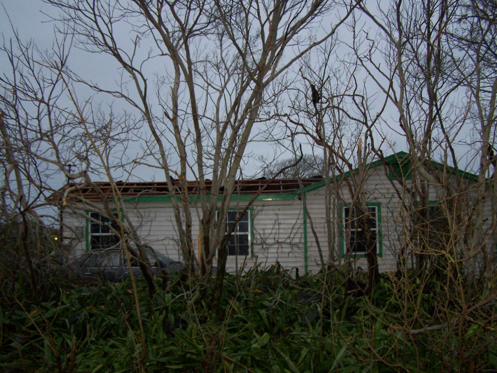
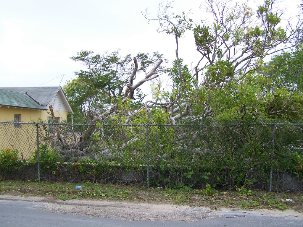
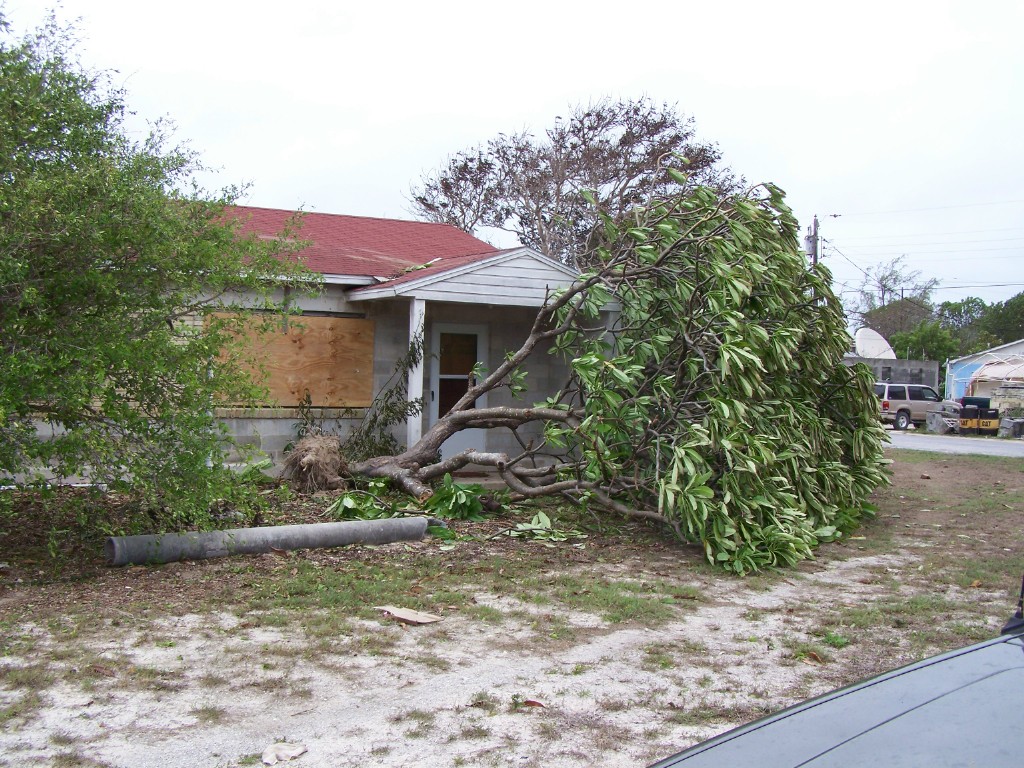
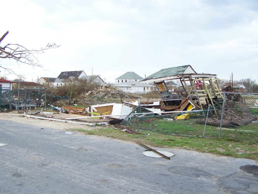
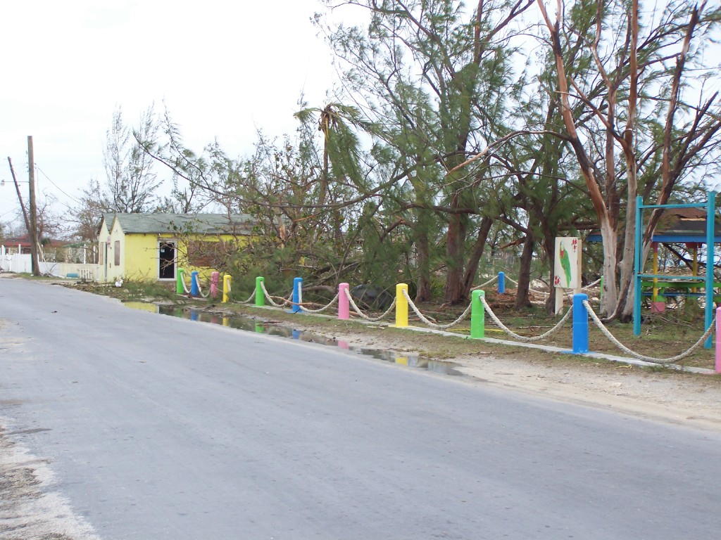
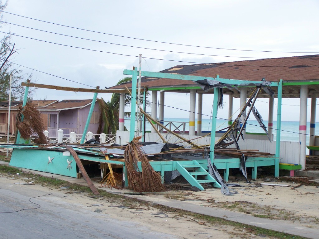
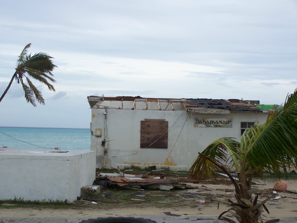
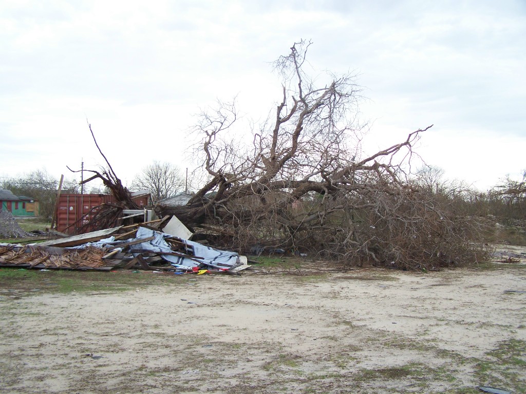
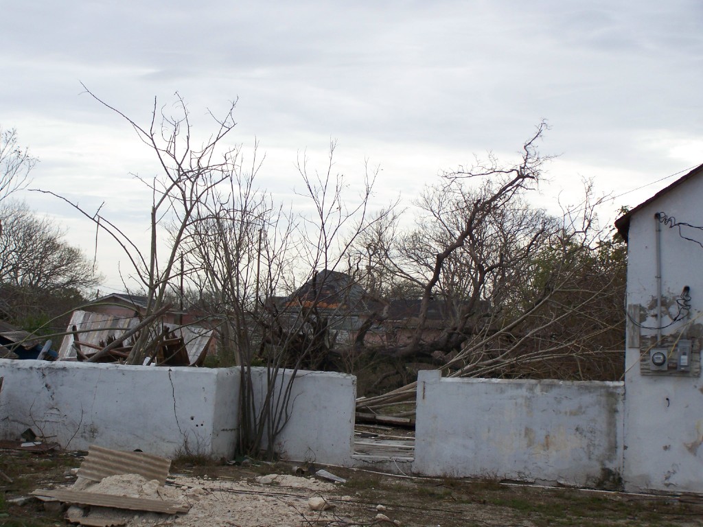
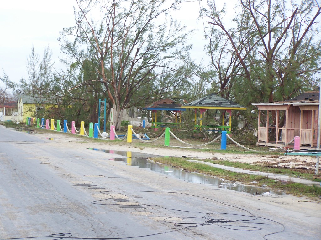
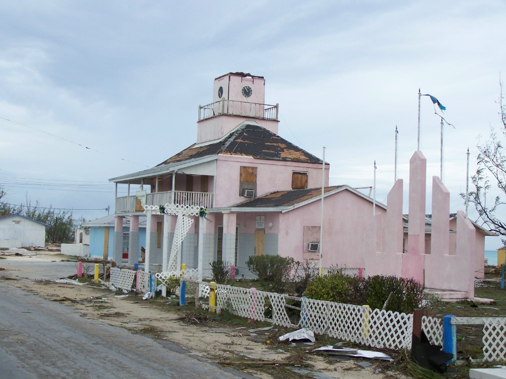
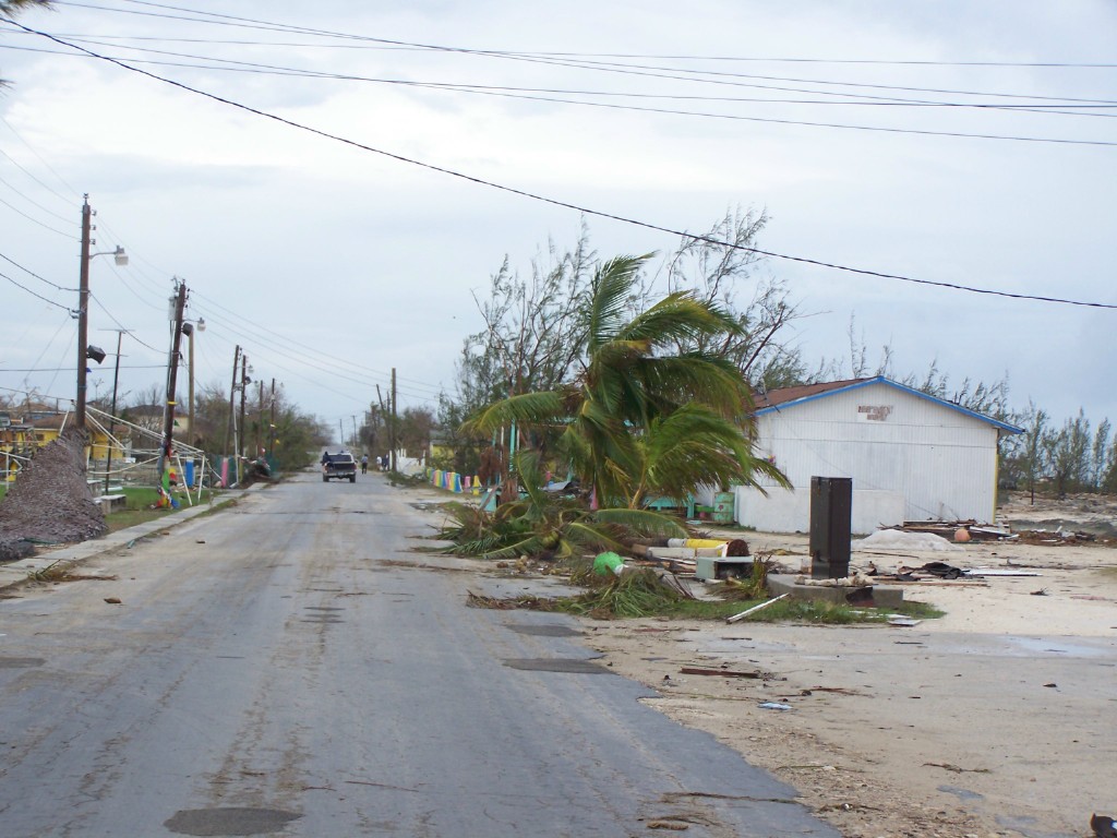
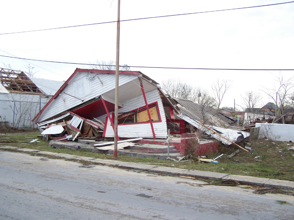
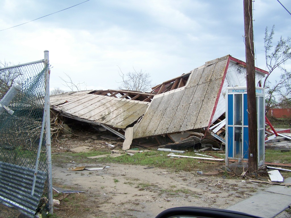
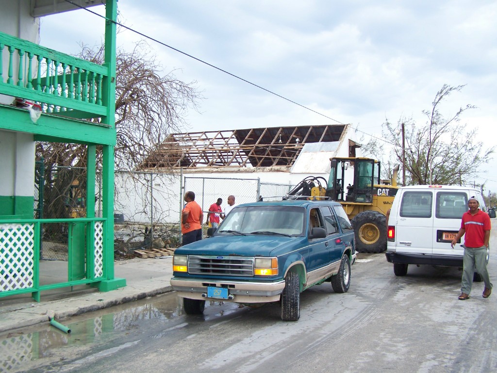
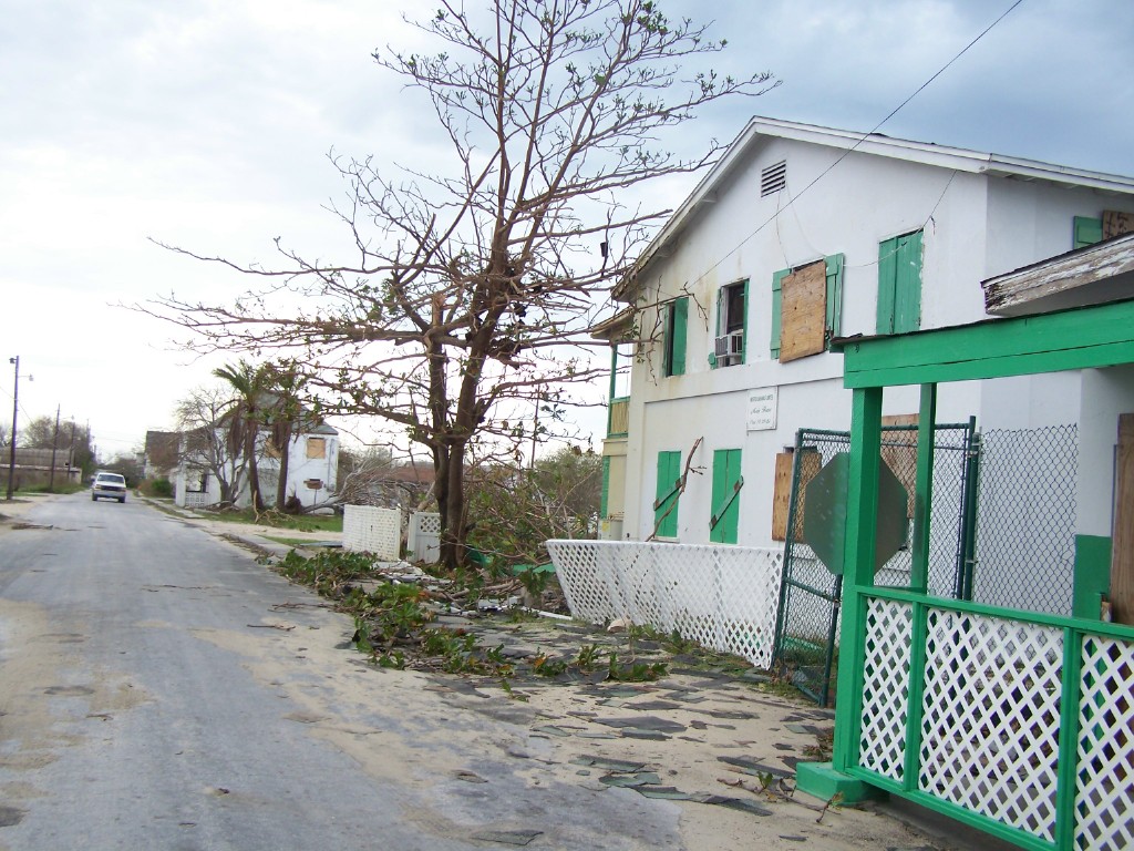
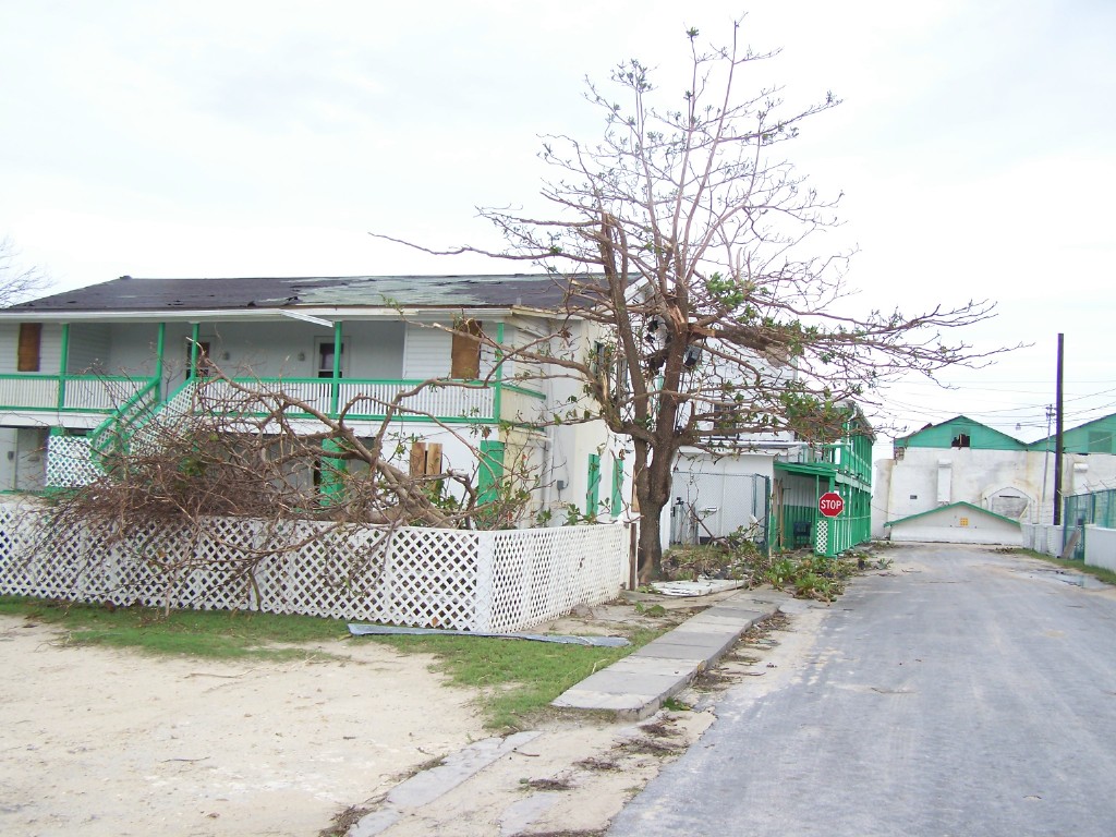
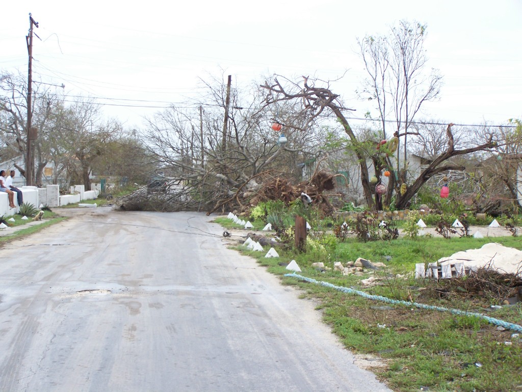
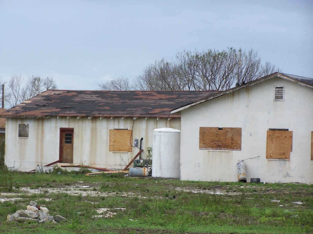
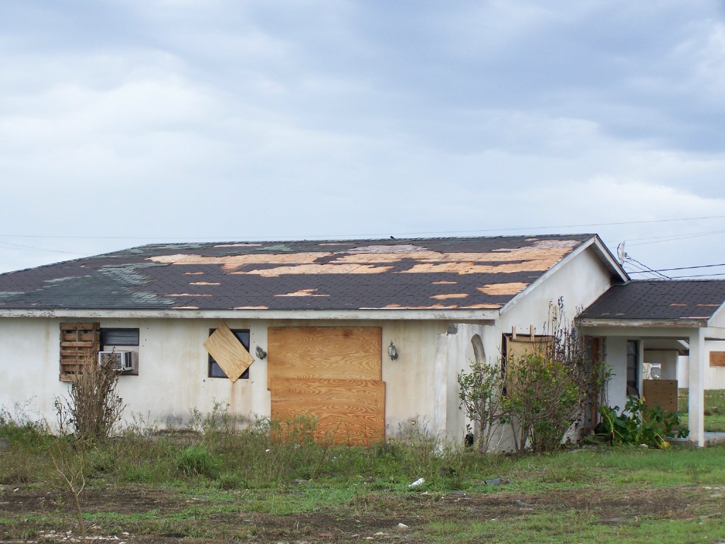
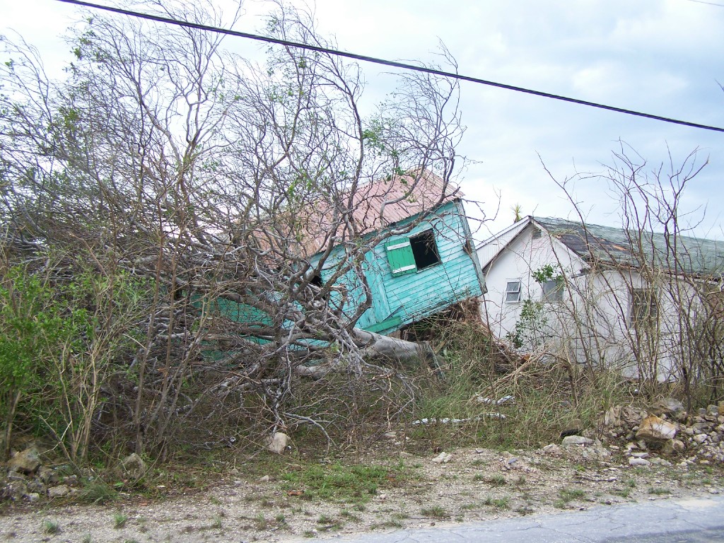
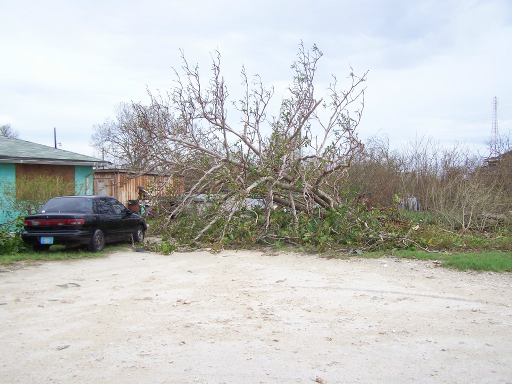
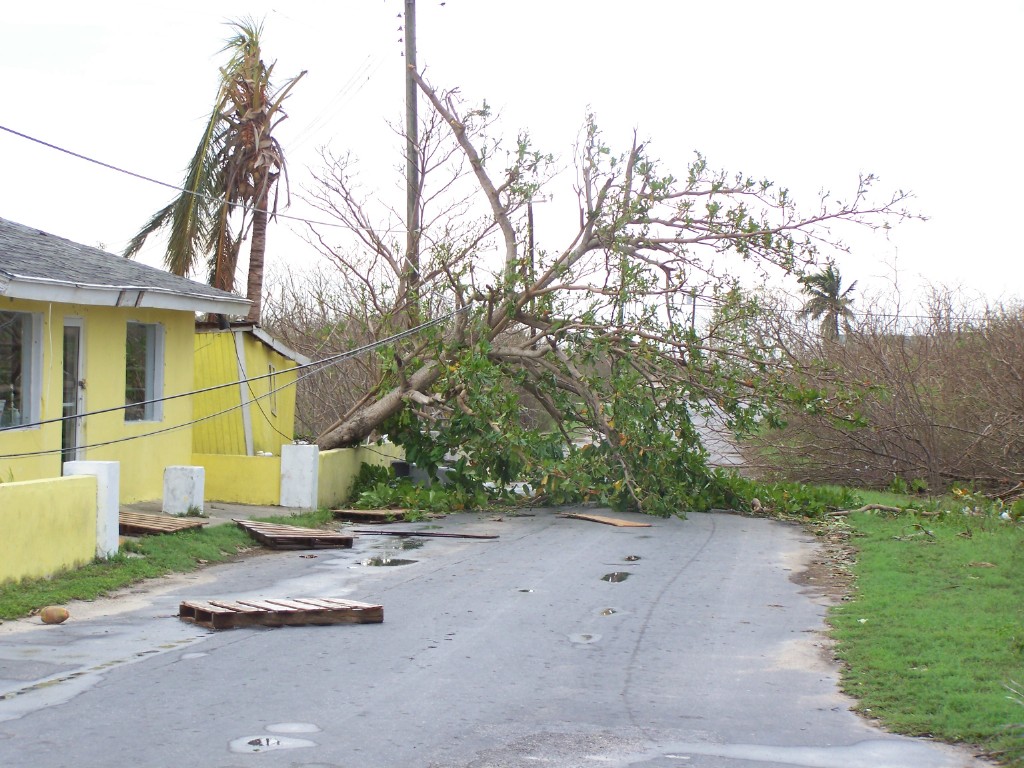
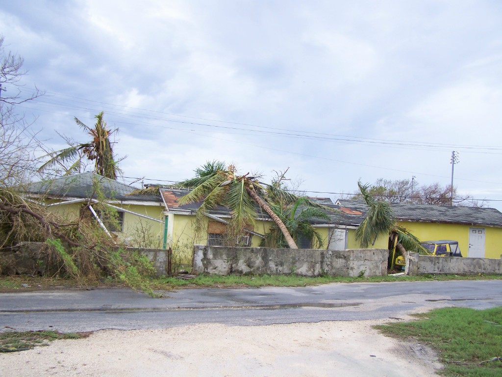
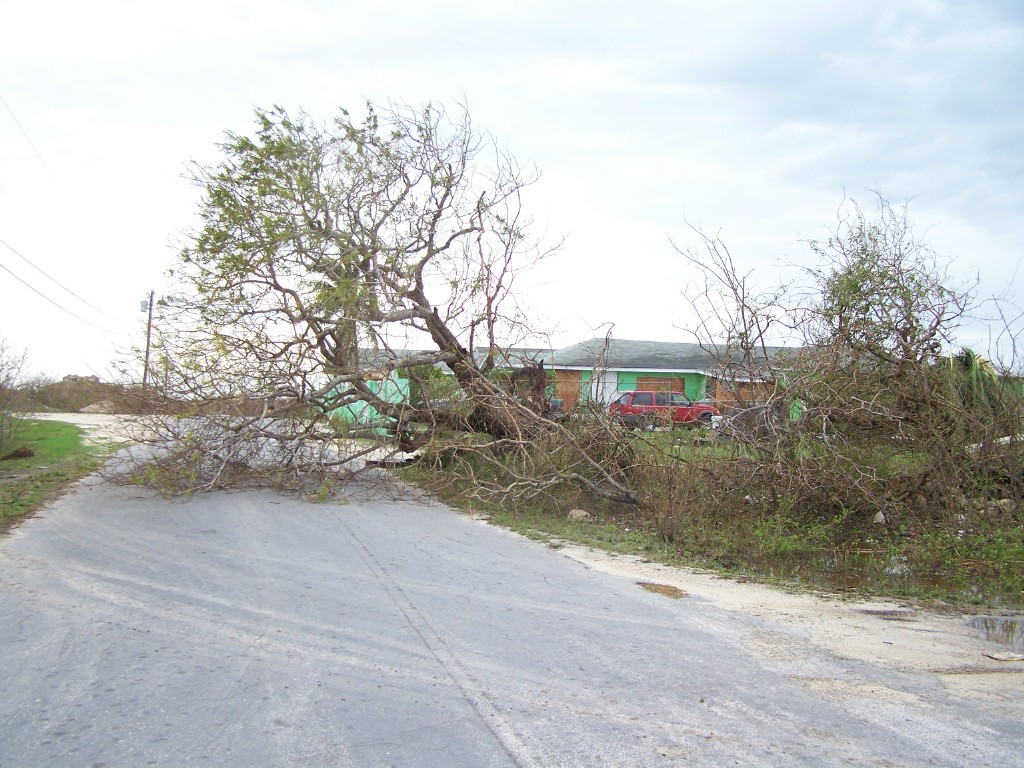
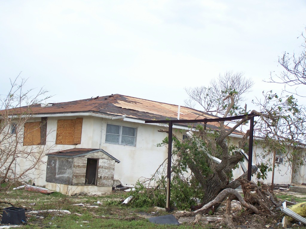
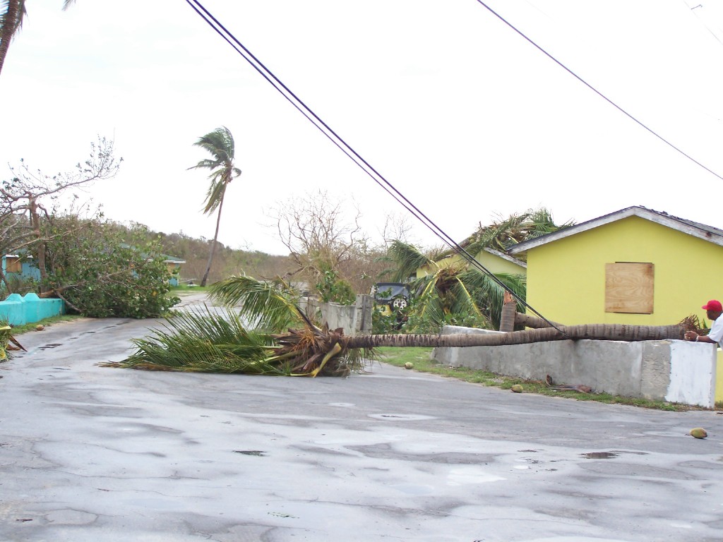
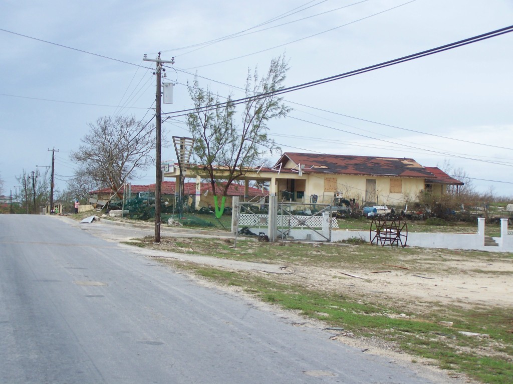
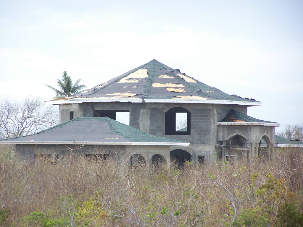
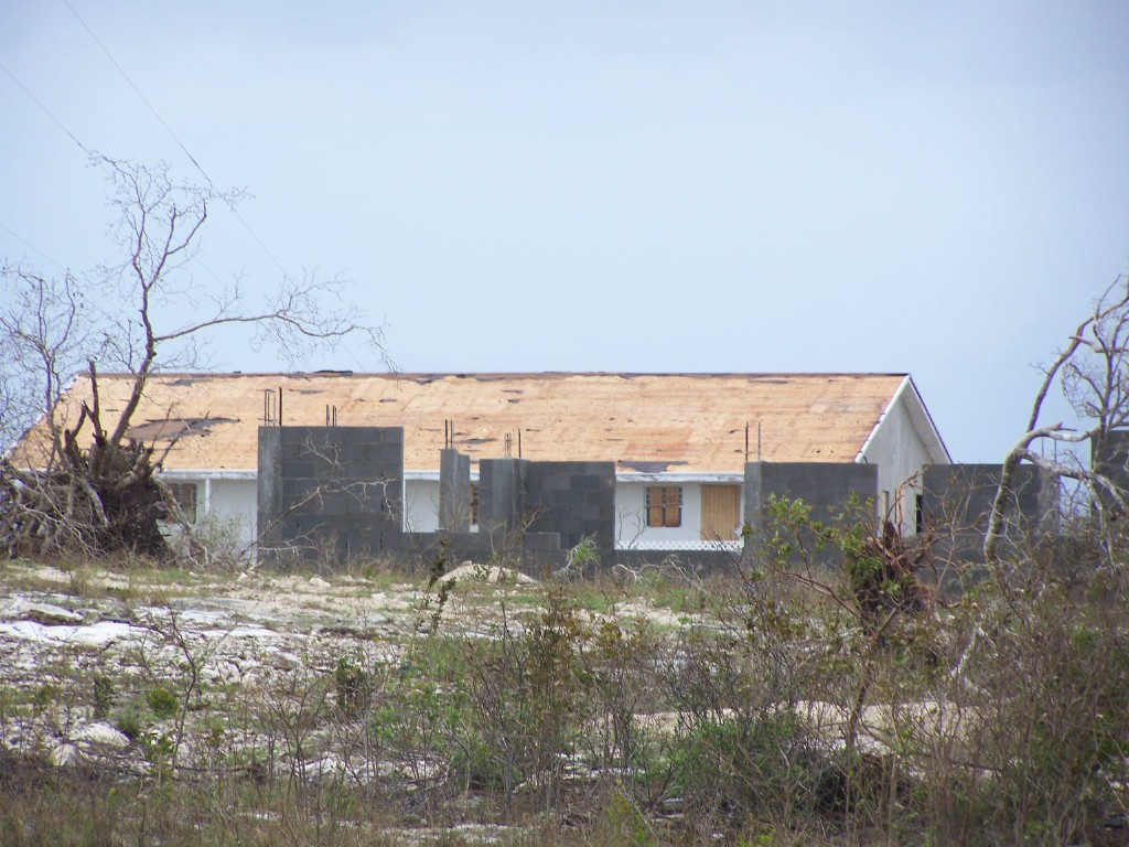
- FW: Hurricane Ike Aftermath in Inagua 2008 (fwd)
|
- From: Gert van Dijken <gert at vandijken.com>
- Date: Tue, 16 Sep 2008 11:10:11 -0400 (EDT)
|
Date: Tue, 16 Sep 2008 11:33:57 +0000
From: Adrian Chriswell <abchriswell at hotmail.com>
Subject: FW: Hurricane Ike Aftermath in Inagua 2008
Some photos from Inagua. Doesn't look too bad from these, but I've seen
some worse ones in the local papers and TV. The one major employer on the
island may never reopen. I think it all depends on how flexible the govt
is with their exemptions and how flexible the unionized workers become;
there has been a lot of unrest lately with union demands and costs of
doing business in Bahamas as opposed to their salinas in Mexico,
etc.Adrian at Rum CayFish in Peace
Attachment:
100_1445.jpg
Description: JPEG image
Attachment:
100_1442.jpg
Description: JPEG image
Attachment:
100_1443.jpg
Description: JPEG image
Attachment:
100_1436.jpg
Description: JPEG image
Attachment:
100_1614.jpg
Description: JPEG image
Attachment:
100_1615.jpg
Description: JPEG image
Attachment:
100_1611.jpg
Description: JPEG image
Attachment:
100_1610.jpg
Description: JPEG image
Attachment:
100_1609.jpg
Description: JPEG image
Attachment:
100_1608.jpg
Description: JPEG image
Attachment:
100_1612.jpg
Description: JPEG image
Attachment:
100_1604.jpg
Description: JPEG image
Attachment:
100_1605.jpg
Description: JPEG image
Attachment:
100_1607.jpg
Description: JPEG image
Attachment:
100_1603.jpg
Description: JPEG image
Attachment:
100_1602.jpg
Description: JPEG image
Attachment:
100_1601.jpg
Description: JPEG image
Attachment:
100_1600.jpg
Description: JPEG image
Attachment:
100_1597.jpg
Description: JPEG image
Attachment:
100_1599.jpg
Description: JPEG image
Attachment:
100_1598.jpg
Description: JPEG image
Attachment:
100_1596.jpg
Description: JPEG image
Attachment:
100_1592.jpg
Description: JPEG image
Attachment:
100_1589.jpg
Description: JPEG image
Attachment:
100_1588.jpg
Description: JPEG image
Attachment:
100_1590.jpg
Description: JPEG image
Attachment:
100_1591.jpg
Description: JPEG image
Attachment:
100_1594.jpg
Description: JPEG image
Attachment:
100_1587.jpg
Description: JPEG image
Attachment:
100_1586.jpg
Description: JPEG image
Attachment:
100_1585.jpg
Description: JPEG image
Attachment:
100_1584.jpg
Description: JPEG image
|
|
- Inagua update
|
- From: "Bridget Hogg" <adelphi at batelnet.bs>
- Date: Wed, 10 Sep 2008 23:28:11 -0400
|
Private citizens,businesses, government agencies and NGOs
are coming together to provide much needed support to Inagua
residents. These include the Anglican Church, Dunamus
Sounds, The Red Cross , The Salvation Army, The Bahamas
National Trust and others. Much work will need to be done to
restore Inagua to its former tranquil , inviting state.

Although, to date there has been no report of deaths amongst
the populace, the island's economy will be very much
challenged due to infrastructural losses as a result of  the
fury of hurricane Ike. Residents await restoration of land
lines, electricity and water.

The impact on wildlife and their habitats( terrestrial and
aquatic )as well on domestic animals remains  to be
determined. Reports on the flamingo population have been,
initially positive.

Here in the eastern end of New Providence, the winds are now
nothing more than gentle summer night embraces that gently
cool sleep creeps upon a weary soul.

 Our thoughts and best wishes continue to be with those who
have been significantly affected by recent storms in this
region.
|
|
- San Salvador flight to Inagua
|
- From: Sandra Pitt <romperpitt at yahoo.com>
- Date: Wed, 10 Sep 2008 06:56:57 -0700 (PDT)
|
Yesterday Tuesday the 9th Sept a flight went to Inagua with donations from the Islanders & residents of San Salvador. The flight was organized By locals & flown by Manfred Roon on his plane .
Also there were the PM The Rt Hon Hubert Ingram & other relief flights.
We do hope we can get together & do more flights from here.
Sandra Pitt.
|
|
|
- Good News For Inagua's Flamingoes
|
- From: "Bridget Hogg" <adelphi at batelnet.bs>
- Date: Tue, 09 Sep 2008 17:04:13 -0400
|
Special thanks to K. Wang for directing me to available data
on the Inagua flamingos. A regional Associated Press report
provides statements from the island's National Park warden,
Mr. Henry Nixon - thousands of flamingos survived the storm
unharmed, as did their primary breeding gorunds .There were
relatively few bird casualties.
|
|
- Goodbye Ike
|
- From: "Bridget Hogg" <adelphi at batelnet.bs>
- Date: Mon, 08 Sep 2008 23:23:27 -0400
|
Persons in Inagua paid attention to hurricane alerts and
warnings.To date there are no reported fatalities. Many
buildings were damaged, storm shutters were ripped off
buildings. The Batelco ( local phone company) land lines are
down but cellular service is still available. Zion Baptist
Church  had damage to the sunday school roof. The Morton
Salt facility in Great Inagua is reported to have sustained
substantial damage.Electricity service is out .
There is no information as yet as to how the Flamingo
population of Inagua has been affected by Ike.

The airport at Inagua has reopened and relief efforts have
begun.Assessment of damage is currently taking place.

THe local newstation - ZNS TV 13 ,reports that Crooked
Island and Andros
fared well with no reported injuries or casualties.

Damage assessment will begin shortly in Acklins .Island
administrators report that the power is off.

Here in New Providence there is sporadic rain and moderate
gusts.Ike has had minimal direct inpact on New Providence.

It is with relief that we watch Ike depart, and with hope
and best wishes for thos who may yet be affected.
|
|
- Hurricane Ike -Situation Report #2 (fwd)
|
- From: Gert van Dijken <gert at vandijken.com>
- Date: Mon, 8 Sep 2008 19:38:27 -0400 (EDT)
|
---------- Forwarded message ----------
Date: 8 Sep 2008 23:34:30 -0000
Subject: Hurricane Ike -Situation Report #2

      Message: Damage Assessment underway in the Turks and Caicos Islands and
the Southern Islands of the Bahamas (2:00pm Sept. 8. 2008)
     EVENT:
     Hurricane Ike affected the Turks and Caicos Islands and the Great Inagua
Bahamas Islands on Saturday September 7, 2008.? At the time of impact Ike was a
Category 4 storm on the Saffir-Simpson Scale. At 2:00pm EDT today (Sept. 8),
2008, the Andros and Ragged Islands in the Bahamas remained under a Tropical
Storm warning.
     The Jamaican government has discontinued the Tropical Storm Watch for that
island.
     Situation Update:
     There have been no reports of fatalities or injuries on the Bahamas or
Turks and Caicos Islands.The Turks and Caicos Islands have been severely
affected and preliminary damage assessment is currently underway.

     The Southern island of Inagua sustained significant damage and the other
southern islands of such as Mayaguana, Acklins and Crooked island sustained
lesser degrees of damage.
     BAHAMAS:
     Initial reports from Great Inagua indicate the following:
     Housing:
     Approximately 70 to 80 percent of the houses on Great Inagua have
sustained roof damage and approximately 25 per cent sustained major damage.
     Electricity Supply:
     Island wide power outage has been experienced due to fallen poles
     Ports:
     Both the airport and the seaport are open.
     National Response:
     A relief flight with emergencies supplies was scheduled to leave at 12:00
midday for Great Inagua.? A second flight is scheduled for Tuesday September
09, 2008
     A damage assessment team scheduled to be on the flight today would
comprise of social services, health, water and sewage, works and environment
and telecommunications experts. Senior government officials are expected to
visit the affected areas on Tuesday, September 9, 2008.
     Military vessels that were in safe harbor during the passage of Hurricane
Ike will be involved in the recovery operations on their return to the Bahamas.
     TURKS AND CAICOS ISLANDS
     Initial reports from Turks and Caicos Islands indicate the following:
     Grand Turk Island
     Shelters:
     348 people are in shelters.
     Housing:
     An estimated 90 % of the roofs sustained damage and 20% destroyed.
     Health
     Grand Turk hospital sustained roof and water damage.
     Utilities
     Electricity and telephone services are not available because most power
lines are down.
     Salt Cay
     A reconnaissance flight over the island has reported severe flooding in
southern part of the Salt Cay and significant damage to homes and buildings.
     Water & Electricity
     Water and electricity supplies have been interrupted and there is some
concern with regard to the public water supplies. Citizens are being encouraged
to boil all drinking water.
     National Response:
     National Damage Assessment and Technical Teams are on the ground in Turks
and Caicos Islands conducting preliminary damage assessment.
     REGIONAL and Other RESPONSE:
     ?A CDERA six-member damage assessment and needs analysis team arrived in
Providenciales , Turks and Caicos Islands today, September 8, 2008. The team is
comprised of technical experts in the areas of health, infrastructure,
telecommunication, electricty and social services and was deployed from
Jamaica, the sub-regional focal point for this area in the CDERA System
     The CDERA Coordinating Unit’s Technical Manager for Preparedness and
Country Support, Mrs. Andria Grosvenor also arrived in Providenciales at
approximately 4:15PM today.
     On Tuesday, Sept 9, technical support to the Department of Disaster and
Emergencies in the TCI will be strengthened through the arrival of:
     •?A Disaster Management Officer from the International Federation of
Red Cross and Crescent Societies and,
     •?The National Disaster Coordinator from Saint Lucia
     The CDERA CU has on standby a team of military engineers from the Regional
Defence Forces to provide support for the TCI. Deployment will be informed by
the specific needs requests made by TCI.
     The National Emergency Management Organisation in Belize has scheduled a
meeting to discuss support for the TCI.
     The British Guard Ship the HMS Iron Duke has responded to the emergency
and is presently in the Grand Turk providing support to the Department of
Disaster and Emergencies
     The CARICOM Disaster Relief Unit has been stood down.
     CDERA will continue to provide updates as necessary.
     Contact Details: The CDERA CU 24hr contact number is 246 425 0386
     ?
|
|
- Inagua
|
- From: Gert van Dijken <gert at vandijken.com>
- Date: Mon, 8 Sep 2008 10:57:39 -0400 (EDT)
|
Lily, a hurricane correspondent on Nassau told me the following:
Our local news last night, advised that there were no reported casualties
on the island of Inagua. The Government will be doing a full assessment
of the damages within the next couple of days.
*
**
*** Gert van Dijken ( gert at vandijken.com )
**** Caribbean Hurricane Network - http://stormcarib.com
|
|
- Ike Batters Southeast Bahamas
|
- From: "Kimberly King-Burns" <kkingburns at convergenz.com>
- Date: Sun, 7 Sep 2008 22:20:01 -0700
|
http://www.jonesbahamas.com/
September 8th, 2008
Ike Batters Southeast Bahamas
By NAVARDO SAUNDERS

Powerful Hurricane Ike left the southeastern Bahamas in a shambles on
Sunday.
The category four cyclone caused severe damages to critical infrastructure,
homes, schools and government buildings.

Prime Minister Hubert Ingraham described the aftermath of the storm on
Sundays as devastating, but said the situation could have been much worse
considering that Ike was packing winds up to 135 miles per hour and storm
surges of up to 18 feet when the storm unleashed its wrath on islands in the
southeastern Bahamas.

Nowhere was Ike's fury felt more though than in Inagua.

Interim director of the National Emergency Management Agency (NEMA) Stephen
Russell said Ike left behind major destruction in Inagua.

"The situation is dire in Inagua," he said. "There is widespread
destruction."

Prime Minister Ingraham emphasized that buildings and infrastructure can be
replaced, but human life cannot and therefore there was much to be thankful
for since no loss of life or serious injury had been reported.

The prime minister said he would travel to Inagua to view and assess the
devastation first-hand, but that he had not yet set a date.

Tellis Symonette, vice president of wireless and internet service at the
Bahamas Telecommunications Company, said BTC 's office in Matthew Town,
Inagua, suffered extensive damages.

He said the strong winds and torrential rains tore down a satellite
communications system, which subsequently left a gaping hole in the roof.

Mr. Symonette said water rained down on the equipment in the building,
causing severe damages.

However, he said the TDMA and GSM systems were up and running.

"But we don't know how long that will last because the equipment is still
exposed," Mr. Symonette said.

Kevin Basden, general manager of the Bahamas Electricity Corporation, said
there were many poles, utility lines and transformers that were leveled.

"BEC will conduct a full assessment of the situation Monday morning," he
said. "We will also deploy technicians and linesmen from Nassau to assist
their colleagues in Inagua with the restoration of power."

Up to Sunday evening Inagua had been without electricity.

Mr. Basden also reported that land and power lines were down in Mayaguana
and Acklins

  Defence Force commodore Clifford Scavella said there was minimum damage to
the Defence Force base in Inagua.

"A portion of the roof was destroyed," he said. "And there were other minor
damages. But the officers stationed in Inagua are ready to lend assistance
and as soon as NEMA gives the order they are prepared to take action."

Shanandor Evans, acting assistant commissioner of police, reported that the
shutters on the police station and the police residences were blown away,
resulting in massive flooding.

But he said that the damage did not hamper the officers' ability to respond
to any emergency.

Melanie Zonicle, director of the Department of Social Services, said the
shutters were also blown off the shelter at St. Philips Community Center and
at Zion Baptist Church, which also resulted in flooding.

She also said the roof on the church caved in. Evacuees housed in another
section of the church were forced to move to the main section of the church.


Glenn Bannister, manager director of Morton Salt Bahamas, said on Sunday
that Inagua was feeling the full brunt of the storm when he spoke to the
Bahama Journal yesterday.

Many people, he said, were staying in shelters and could only watch as Ike
tore off some roofs, leveled power lines and destroyed boats, including some
fishing vessels.

Mr. Bannister said some shelters were also damaged. The roof of at least one
shelter started to give way he said and people started to crowd one area to
avoid being injured.

"It looks like we have been hit hard," Mr. Bannister said. "From what I can
see there is quite a bit of damage."

Mr. Bannister said the total impact of the storm could not be determined
until the storm had passed, but from what he had seen so far there was
extensive damage.

Prime Minister Ingraham said teams from the various government agencies
would be dispatched to Inagua and some of the other affected islands in the
southeastern Bahamas as early as Monday to conduct assessment.

The prime minister said a main focus of the government is to get children
back to school.

As a result he said schools would be among the first to be assessed by the
Ministry of Works.

Mr. Ingraham said he has confidence in the relevant government agencies and
believes that Inagua and the other affected island would be restored in a
reasonable time.
|
|
- News from Inagua
|
- From: "Kimberly King-Burns" <kkingburns at convergenz.com>
- Date: Sun, 7 Sep 2008 16:11:26 -0700
|
NEWS BRIEFING FROM INAGUA
By National Emergency Managment Agency, NEMA

Inagua:

* Roof of BTC office Matthew Town severely damaged when communications
satellite fell through. Land lines down throughout the island.
* The Police Station/residence shutters blown away causing water breach and
flooding
* Hurricane Shelter at St. Philips Community Centre shutters have blown off
causing a water breach.
* The second shelter at Zion Baptist Church, water breach from the Sunday
school section roof. Persons have moved into the main section of the church.
* Land lines in Mayaguana, Acklins are out due to power outage since
Saturday night.

http://www.bahamaislandsinfo.com/ind...nds&Itemid=149
|
|
- Inagua
|
- From: "Ryan Carroll" <ryanac1 at gmail.com>
- Date: Sun, 7 Sep 2008 13:45:21 -0400
|
|
Hi,
talked to a friend who's father and mother lives in Inagua. 2 hours ago residents reported sounds akin to a freight train as the eye rumbled across the Island. With about a thousand people living on the island there are two well built churches able to shelter as many residents willing to leave their mostly wooden houses some as old a 100 years. More details later when I can again talk to Jensen Ferguson son of residents living there.
Ryan C.
|
|
- San salvador
|
- From: Sandra Pitt <romperpitt at yahoo.com>
- Date: Sun, 7 Sep 2008 05:20:24 -0700 (PDT)
|
We have been lucky again will miss most of IKE but am wondering if anyone in the south East Bahamas or Turks & Caicos Islands are able to report anything !!! Am Listening to Nassau radio right now getting some Info from Inagua where the big Flamingo Park is .
We do hope you are all safe. Please take care. Sandra .
|
|
|
- ike
|
- From: angela culmer <angelaculmer at msn.com>
- Date: Sat, 6 Sep 2008 12:38:31 +0000
|
Well Hanna came and went. Although I heard from someone in Eleuthera who suffered some damage to her house it was flooded.
We must have slept through it.
We are watching Ike and looking at all the updates.
Everyone is busily making preparations we have our water batteries and canned goods.
We are just playing the waiting game.
Keep us in our prayers.
A.Culmer
Invite your mail contacts to join your friends list with Windows Live Spaces. It's easy! Try it!
|
|
|
- TROPICAL STORM HANNA
|
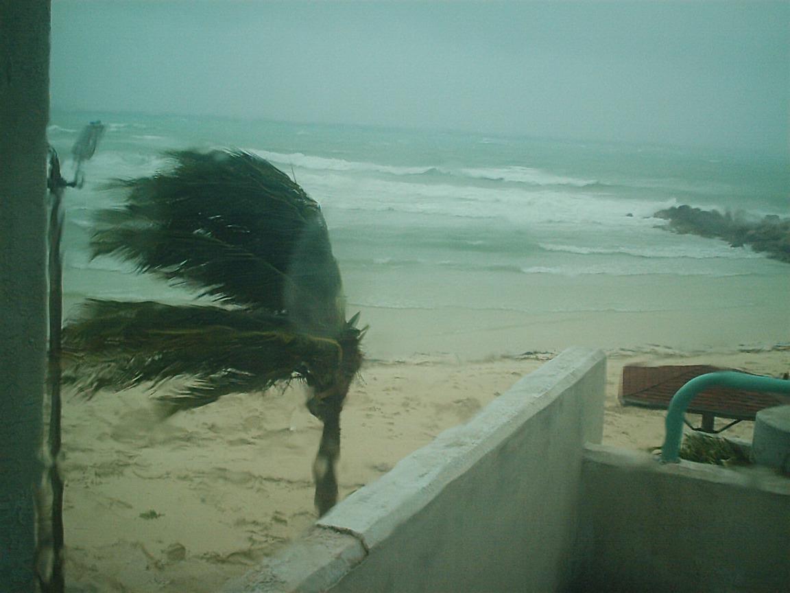
- From: "John Roberts" <ghpsafari at hotmail.com>
- Date: Fri, 5 Sep 2008 19:47:48 -0400
|
|
Freeport, Grand Bahama
1910L - 5 September 2008
After a rather stormy night, this afternoon's
breeze was soft and warm. During the night wind speeds reached 47 knots and
barometric pressure bottomed out at 29.40. On a drive around part of the Island,
leaves and branches were down and some partial flooding - the General Aviation
parking lot at the airport is flooded as is the airport service road around the
airport entrance.
The heavy rain ceased around midday and the sun
came out.
Attached photograph taken at Tyne Beach at 0900
this morning.
Now all eyes are focused on Hurricane
Ike........
Capt. John Roberts
Fishermans Safari
|
Attachment:
IM001451.JPG
Description: JPEG image
|
|
- Advisory #2-Hurricane Ike (fwd)
|
- From: Gert van Dijken <gert at vandijken.com>
- Date: Fri, 5 Sep 2008 18:51:01 -0400 (EDT)
|
---------- Forwarded message ----------
Date: 5 Sep 2008 22:32:43 -0000
Subject: Advisory #2-Hurricane Ike

      Message:? Hurricane Ike heads toward the Bahamas (As at 5.00p.m.
September 5, 2008)
     The Situation:
     A Hurricane Watch is effect for the Turks and Caicos islands and the
Southeastern Bahamas.
     At 5.00 p.m? today, September 5, 2008 the centre of Hurricane Ike was
located near latitude 22.9 North and longitude 64.1 West or about 430 miles
(690 km) northeast of the Leeward Islands and about 460 miles (735 km)
east-northeast of Grand Turk Island.
     Ike is moving toward the west-southwest near 15 mph (24 km/hr) . A motion
toward the west or west-southwest is expected tonight and tomorrow with a
general motion to the west expected by Sunday. On this track Ike could be near
the Turks and Caicos Islands and the southeastern Bahamas early Sunday.
     Hurricane Ike is a category three hurricane on the Saffir-Simpson scale
with maximum sustained winds near 115 mph (185 km/hr) with higher gusts.
Hurricane Hurricane force winds extend outward up to 45 miles (75 km) from? the
center and tropical storm force winds extend outward up to 120? miles (195 km).
     Hurricane Ike is expected to be a major hurricane as it nears the
hurricane watch area.
     National Actions:
     Even as damage assessments and recovery efforts are being carried out in
the? Bahamas and the Turks and Caicos Islands in the wake of Hurricane Hanna,
monitoring and preparing for Hurricane Ike is now priority.
     The National Emergency Management Agency in the Bahamas has reported that
urgent preparations are being advanced for a probable impact from? Ike.
     Reports from the Turks and Caicos Islands Department of Disasters and
Emergencies Office have indicated that extensive planning is underway for Ike
and this is being supported by a UK Support Team.? Tourists are being
transferred off the Islands and Salt Cay is being evacuated. Arrangements are
being made to obtain emergency food from Miami.
     Regional Response:
     The Caribbean Institute of Meteorology and Hydrology continues to brief
CDERA on the progress of Ike and to provide analysis on its development and
probable effect on the islands.
     CDERA has developed scenarios to assist its response planning operations
and has shared these with the threatened states, Jamaica sub-regional focal
points and other critical members of the Regional Response Mechanism.
     Radio and other communications checks with the Bahamas and Turks and
Caicos Islands are being carried out by CDERA.
     CDERA is in the process of coordinating arrangements to have in place a
damage assessment team on standy for deployment to TCI in the event that they
are affected by Hurricane Ike.
     The Regional Response Mechanism is also on standby.
     Contact Details: The CDERA CU 24hr contact number is 1 246 425 0386
|
|
- Hannah streamed by
|
- From: Malcolm Spicer <msabacom at yahoo.com>
- Date: Fri, 5 Sep 2008 11:22:59 -0700 (PDT)
|
2:20pm Friday now and the winds have just stopped. Hannah came along us during the night with some heavy winds, blowing over our banana trees and part of our fence. Quite a bit of rain with some roads temporarily flooded especially the Spring City part. Estimate 60mph winds. Everyone was prepared and boarded up, I think more in expectance of Ike. Blue skies now with a strong breeze, making it great outside.
Malcolm
Abaco |
|
|
- TS Hanna from San salvador
|
- From: Sandra Pitt <romperpitt at yahoo.com>
- Date: Thu, 4 Sep 2008 18:02:39 -0700 (PDT)
|
9pm Thurs Sept 4th. Winds are finally dying down a little here. Power & Phones been on & off today. Hopefully calm tomorrow to prepare more for IKE. We are all praying it goes away !!
Sandra .
|
|
|
- Goodbye Hanna
|
- From: "Bridget Hogg" <adelphi at batelnet.bs>
- Date: Thu, 04 Sep 2008 19:52:00 -0400
|
The breezes have picked up somewhat. Rain is still very
sporadic. Otherwise its cool and quiet. Meanwhile Ike is
threatening to arrive early next week. The models show a
broad variation in paths. THe best for us all would be a
path that takes him back up and away from all land. We
continue to watch and hope.
|
|
- Hanna and Ike
|
- From: angela culmer <angelaculmer at msn.com>
- Date: Thu, 4 Sep 2008 18:06:58 +0000
|
Hi There
Well we are busy busily preparing for the impact of Ike which seems to be a bigger threat than Hanna.
The stores are busy hurricane shutters are going up and i heard hammers and drills until the wee hours of the morning.
As we are boarded up it was difficult to know what time it was this morning.
I am beginning to worry a little about my husband who is stuck on his boat in the Berry islands.
Continue to remember The Bahamas in your prayers.
Thank you
A Culmer
Connect to the next generation of MSN Messenger Get it now!
|
|
|
- San Salvador.
|
- From: Sandra Pitt <romperpitt at yahoo.com>
- Date: Thu, 4 Sep 2008 05:06:40 -0700 (PDT)
|
We are now getting the most we will get as it moves well to our East.
For anyone interested Nassau Sir Linden Pindling Airport will close at 2pm today.
Sandra. 8/06 am.
|
|
|
- San Salvador
|
- From: Sandra Pitt <romperpitt at yahoo.com>
- Date: Thu, 4 Sep 2008 04:44:58 -0700 (PDT)
|
Winds Really picked up over night & some rain showers along with it but significant Phones are down on the island. The wind will probably be with us most of the day, Now watching out For IKE.
Hope all are safe in the Islands around us Sandra .
|
|
|
- Hanna
|
- From: "Bridget Hogg" <adelphi at batelnet.bs>
- Date: Wed, 03 Sep 2008 22:40:14 -0400
|
Home and business owners have been busy today installing
shutters,removing yard debris and completing general storm
preparations. Most academic institutions will be closed all
day.Business owners have posted signs indicating reduction
in service hours for Thursday and Friday.
the mood seems to be an uneasy wait and see one.

Currently there is only a gentle breeze to be felt at the
eastern end of the island. The streets are quiet .and we ,
in New Providence, wait for Hanna.
|
|
- Situation Report #2 -Tropical Storm Hanna (fwd)
|
- From: Gert van Dijken <gert at vandijken.com>
- Date: Wed, 3 Sep 2008 19:13:32 -0400 (EDT)
|
---------- Forwarded message ----------
Date: 3 Sep 2008 22:49:56 -0000
Subject: Situation Report #2 -Tropical Storm Hanna

      Message: Hanna beginning to move north-northwestward (As of 2.00 p.m,
September 3, 2008)
     Event: ?
     As of 2.00pm September 3, 2008 a Hurricane Warning remains in effect for
the central Bahamas, southeastern Bahamas and the Turks and Caicos islands. A
hurricane watch is in effect for the northwestern Bahamas.? The centre of
Tropical Storm Hanna was located near latitude 21.4 north and longitude 72.0
west or just south of the Turks and Caicos.

     Maximum sustained winds are near 60 mph (95 km/hr) with higher gusts.
Hanna is a large tropical cyclone with Tropical Storm force winds extending
outward up to 290miles (465km) mainly to the north of the centre.

     Rains and strong winds continue to affect the Turks and Caicos Islands and
the southeastern Bahamas.

     Prognosis:
     Hanna is moving towards north-northwest near 10mph. A turn to the
northwest with an increase in forward speed is expected over the next 24 hours.
However, the On this track the centre of Hanna should be moving through or just
east of the central and northwestern Bahamas over the next 48 hours. Hanna is
expected to produce 4 to 8 inches of rain with isolated amounts of up to 12
inches over the southeastern Bahamas and the Turks and Caicos islands. Storm
surge of 1 to 3 feet above normal tide levels can be expected in areas of
onshore flows within the hurricane warning areas.

[...]

     BAHAMAS

     Impact:
     Hanna continues to affect the southeastern Bahamas primarily the islands
of Inagua and Mayaguana.
     ?
     Response:
     The National Emergency Operations Centre remains activated and continues
to provide advice to the public.
     ?
     All communication equipment including Satellite phones and radios were
checked by the police communications centre and found to be operational
     ?
     All national medical facilities were checked and found to be ready with
the necessary supplies and equipment in place.
     ?
     IMPACT
     The National Emergency Management Agency (NEMA) has received the following
updates on the situation from the family of islands.
     ?
     Casualties:
     No causalities have been reported so far.
     ?
     Shelters
     Shelters are either operational or ready to be activated with the
necessary supplies. There are approximately 139 persons in shelters on Acklins
and 20 persons on Long Cay.?

     Utilities
     Electricity has been restored to most of the islands.

     Damage:
     Reports so far are minimal with minor roof damage and fallen trees.

     REGIONAL RESPONSE
     The CDERA Coordinating Unit remains in regular contact with the Bahamas
and the Turks and Caicos to provide support and advice.
     ?
     The Regional Response Mechanism (RRM) remains on standby.
     ?
     CDERA has been collaborating with the Caribbean Institute of Meteorology
and Hydrology for reviewing and analyzing the progress and development of
tropical systems in the Atlantic.? In this regard the CDERA CU is also
monitoring the development two other tropical systems, Tropical Storm Ike and
Josephine.

     As at 11.00a.m. September 3, 2008, the centre of Tropical Storm Ike was
located near latitude 20.8 north and longitude 51.2 west. ?

     As at 11.00a.m. September 3, 2008, the centre of Tropical Storm Josephine
was located near latitude 13.8 north and longitude 28.8 west. ?

     CDERA will continue to monitor the situation and provide advisories as
necessary.
     ?
     Contact Details: The CDERA CU 24hr contact number is _246 425 0386_
|
|
- TS Hanna
|
- From: Sandra Pitt <romperpitt at yahoo.com>
- Date: Wed, 3 Sep 2008 14:53:14 -0700 (PDT)
|
Sandra Pitt reporting in from San Salvador at 5/50pm Wed Sept 3rd.
Winds are slightly picking up & ocean full of swells & white caps, but nothing too much. Looks like we will be spared most of it !!!!
Good luck to all !!!!
|
|
|
- Situation Report #1 -Tropical Storm Hanna (fwd)
|
- From: Gert van Dijken <gert at vandijken.com>
- Date: Tue, 2 Sep 2008 18:59:46 -0400 (EDT)
|
---------- Forwarded message ----------
Date: 2 Sep 2008 22:03:23 -0000
From: webmaster at cdera.org
Subject: Situation Report  #1 -Tropical Storm Hanna

      Message: Heavy Rains and strong winds continue to affect Turks and Caicos
Island and South Eastern Bahamas (as at 2:00p.m, September 2, 2008)
     Event: ?
     A Hurricane Warning remains in effect for the central Bahamas,
southeastern Bahamas and the Turks and Caicos islands. As at 2.00pm, September
2, 2008, the centre of Tropical Storm Hanna was located near latitude 20.6
north and longitude 72.9 west or just southeast of Great Inagua island in the
southeastern Bahamas and about 420 miles southeast of Nassau.
     Maximum sustained winds are near 70 mph (110 km/hr) with higher gusts.
Tropical storm force winds extend outward up to 175 miles (280km) from the
centre.
     ?Rains and strong winds have been affecting the Turks and Caicos Islands
and the southeastern Bahamas over the last 36 hours.
     Prognosis:
     Hanna is drifting southeastward today however, the forecast indicates that
a northwestward motion is expected to begin tonight or tomorrow.??On this track
Hanna will be moving over the southeastern Bahamas tonight and central Bahamas
tomorrow and produce 4 to 8 inches of rain with isolated amounts of up to 12
inches over the southeastern Bahamas and the Turks and Caicos islands
     ?
     TURKS AND CAICOS ISLANDS (TCI)
     Impact
     Hurricane HANNA has been battering the islands of the TCI with strong
winds, high seas and very heavy rain that at times are accompanied by thunder
and lightning.?As a result there is widespread flooding throughout all the
islands.?These conditions were being felt throughout the day and still
continue.?There are reports of fallen trees and minor damage to
roofs.?Preliminary damage assessment will commence as soon as it is safe to do.
     ?
     Response:
     ?The National Emergency Operations Centre (NEOC) which serves as the
coordinating centre for all the islands of the TCI has been activated and is
being manned by the staff of the Office of Disaster and Emergencies.
     Search and rescue operations are being??
     ?
     Airports:
     All airports were closed at 13.30hrs on Monday, September 1.
     ?
     Casualties:
     No deaths have been reported. Reports of missing persons on
     the island of Providenciales are being investigated by the police.
     ?
     Shelters:
     Many persons have left their homes in low lying areas and are seeking
shelter with family and friends on higher ground. Some churches are also
accommodating persons in need of shelter. Of the shelters activated, 12 persons
are in shelters on Grand Turk, and 225 on Providenciales. The shelter at the
Community Centre on Middle Caicos had to be closed due to the ingress of water
and the shlter at Mt. Oliver Baptist church was activated instead.
     ?
     Damage:
     EOC Providenciales:
     The building has suffered minor damage to one section of the roof and a
window to the front of the building is leaking
     ?
     Housing:
     Minor damage to roofs reported?????????
     ?
     Utilities:
     Fallen utility poles have resulted in loss of electricity to the islands
of Salt Cay, Grand Turk South Caicos, Middle Caicos.?Half the island of North
Caicos is without electricity.?
     ?
     Roads: The causeway connecting middle and North Caicos is impassable
     ?
     BAHAMAS
     Impact:
     Hanna is still affecting the southeastern Bahamas primarily the islands of
Inagua and Mayagua. The National Emergency Operations Centre remain activated
and continue to provide advice to the public. Assessment teams are in place and
will be conducting assessments as soon as it is safe to do so.
     ?
     Regional Response:
     The CDERA Coordinating Unit remains in regular contact with the national
disaster offices of the?Bahamas and the turks and to provide support and advice.
     ?
     The Regional Response Mechanism (RRM) remains on standby.
     ?
     CDERA has been collaborating with the Caribbean Institute of Meteorology
and Hydrology for reviewing and analyzing the progress and development of
tropical systems in the Atlantic.
     In this regard the CDERA CU is also monitoring the development two
other?tropical systems, Tropical Storm Ike and Josephine.
     As at 11.00a.m. September 2, 2008, the centre of Tropical Storm Ike was
located near latitude 18.9 north and longitude 45.0 west. ?
     As at 11.00a.m. September 2, 2008, the centre of Tropical Storm Joesphine
was located near latitude 13.2 north and longitude 25.3 west ?
     CDERA will continue to monitor the situation and provide advisories as
necessary.
     ?

     Contact Details: The CDERA CU 24hr contact number is _246 425 0386_
     ?
     ?
     ?
|
|
- San Salvador
|
- From: Sandra Pitt <romperpitt at yahoo.com>
- Date: Tue, 2 Sep 2008 05:15:21 -0700 (PDT)
|
Sandra Pitt wrote on Tuesday at 8/12am.
Not a lot to report from here right now we are still waiting to see which way it will go. Have had a few gusty winds & raining right now which San Sal really needs. Hopefully the Satellite connection will keep going to post reports.
|
|
|
- Get Ready
|
- From: "Katybel Taylor" <katybel86 at gmail.com>
- Date: Tue, 2 Sep 2008 07:55:32 -0400
|
I am in New England on vacation and unable to send local reports.
Good luck to every island and every person in the Wonderful 700 Islands of the
Bahamas. Be prepared, stay safe.
|
|
|
- Bahamas Update: Hanna Drenches, Ike Looms
|
- From: "Kimberly King-Burns" <kkingburns at convergenz.com>
- Date: Tue, 2 Sep 2008 04:17:47 -0700
|
http://www.jonesbahamas.com
September 2nd, 2008
Hanna Drenches, Ike Looms
By NAVARDO SAUNDERS

Hurricane Hanna left the islands in the southeast Bahamas drenched on Monday
after the category one cyclone unleashed torrential rain for most of the
day.

Packing winds of up to 80 miles per hour, the storm gained strength as it
slowly trekked through the southeast Bahamas. It left behind massive
flooding in Mayaguana, Crooked Island and Long Cay on Monday afternoon.

At an emergency management meeting at the Port Department at the Prince
George Dock, which was broadcast live to the nation, meteorologist Mike
Stubbs said that Hurricane Hanna was sitting on the "doorsteps" of the three
named islands.

"Those islands should be experiencing the effects of the storm as we speak,"
he said. "This is a category one hurricane and I must warn residents it is
nothing to play with. Those living closest to the shorelines are advised to
leave their homes and seek safe shelter closer inland."

On Monday hurricane warnings were issued for the central and southeast
Bahamas, which included Cat Island, the Exuma, Long Island, San Salvador,
Acklins, Ragged Island, Inagua, Mayaguana, Crooked Island, Long Cay and the
Turks and Caicos Islands.

According to Mr. Stubbs, a hurricane warning means that winds in excess of
73 miles per hour can be experienced in those areas within 24 hours.

At 5:00 p.m. the center of Hurricane Hanna was located just east of
Mayaguana, about 30 miles northwest of the Turks and Caicos Islands, 100
miles east-southeast of Acklins Island, about 45 miles north-northeast of
Inagua and about 36 miles east-southeast of New Providence.

"Hanna has been meandering during the last several hours but is expected to
move toward the south-southwest near three miles per hour," according to
weather alert number 21 issued by the Department of Meteorology. "On the
forecast track Hanna will be moving over the Turks and Caicos Islands and
the southeast and Central Bahamas during the next couple of days."

The alert, which was issued at 6:00p.m., stated that maximum sustained winds
had increased to about 80 miles per hour with higher gusts. Little change in
strength was forecasted for the next 24 hours.

Hurricane force winds extended outward up to 70 miles mainly to the
northeast of the center and tropical storm force winds extended outward up
to 160 miles from the center.

"Heavy downpours associated with the rainbands of hurricane Hanna will
generate flooding in the southeastern islands at first and thereafter spread
to the central and northwestern islands over the next few days," the alert
continued. "Large swells will batter the coastline of the Turks and Caicos
Islands, and the southeast and central Bahamas over the next few days. The
swells could spread to the northwest Bahamas if the storm shifts to a west
to northwest track."

Mr. Stubbs said residents in the central and southeast Bahamas and the Turks
and Caicos Islands should have already taken the necessary precautions to
secure their properties.

Small craft operators in the central and southeast Bahamas and the Turks and
Caicos Islands should remain in port and those out to sea should seek safe
harbour.

"Residents in the northeast Bahamas, including New Providence, Grand Bahama,
Abaco, Eleuthera, Andros, Bimini and the Berry Islands should go about their
normal business but continue to monitor the progress of the Hanna and be
prepared to take quick action should the hurricane change its course and
increase its forward speed," Mr. Stubbs said.
---------------
For more storm information and community conversation, surf over to the
Briland Modem at www.briland.com.
|
|
- HURRICANE HANNA
|
- From: John Roberts <ghpsafari at hotmail.com>
- Date: Tue, 2 Sep 2008 06:40:19 -0400
|
Freeport, Grand Bahama
0635 2nd September 2008
CORRECTION to previous report. which should read:
'Hanna is now FORECASTED to become a Cat. II storm'
Capt. John Roberts
Fishermans Safari
Get thousands of games on your PC, your mobile phone, and the web with Windows®. Game with Windows
|
|
|
- HURRICANE HANNA
|
- From: John Roberts <ghpsafari at hotmail.com>
- Date: Tue, 2 Sep 2008 06:30:37 -0400
|
Freeport, Grand Bahama
0630 2nd September 2008
Now that Gustav is fizzling out, the weather wizards should be paying all their attention to Hanna, which is great for us as we are getting updates and positions. Here in Freeport everyone is stocking up on water and food; in Hope Town, Abaco, they are boarding up and tying up boats. We will probably put up our shutters this afternoon, as Hanna is now a Cat. II storm and could come our way at short notice if she turns as forecasted.
If the power holds out, will keep you updated.
Capt. John Roberts
Fishermans Safari
Get thousands of games on your PC, your mobile phone, and the web with Windows®. Game with Windows
|
|
|
- hurricanes, hurricanes and yet more hurricanes
|
- From: angela culmer <angelaculmer at msn.com>
- Date: Tue, 2 Sep 2008 10:24:05 +0000
|
Hi there,
Well life is getting more interesting here, we are obviously making preparations for Hurricane Hanna.
The water depots are very busy as well as food stores and gas stations.
The boats have been asked to stay in port .
My husband is stuck in the Berry islands but is insisting he is safely tied up and will ride out the storm there.
We are going to err the side of caution and put up shutters today will continue to update you today.
A. Culmer
Invite your mail contacts to join your friends list with Windows Live Spaces. It's easy! Try it!
|
|
|
- Hanna
|
- From: "Bridget Hogg" <adelphi at batelnet.bs>
- Date: Tue, 02 Sep 2008 00:04:49 -0400
|
Hanna, Ike and..........Josephine?? Say it aint so!!
Well thankfully Josephine is not yet a reality. However
Hanna is now threatening southeastern Bahamas .

Today was the first day of the Christmas term. Many schools
reopened as normal and apart from several moderate to heavy
downpours, it was a regular school day.

During my drive home this afternoon I observed increased
activities at gas stations ( long lines) water depots(
moderate lines) and two foodstores ( bread and tuna shelves
now bare......corn beef running low) Persons have begin
storm preparation.

Right now, on the island of New Providence ( commonly called
by the name of the capital city, Nassau) there is a light to
moderate breeze swishing through the trees, bringing welcome
cooling to a late summer night.

I will keep you posted as things progress( or would that be
as things deteriorate???)

Stay informed and stay safe.
|
|
- RE: news on hanna
|
- From: angela culmer <angelaculmer at msn.com>
- Date: Sun, 31 Aug 2008 22:33:12 +0000
|
Hi There
Well we have had a beautiful day in Paradise although we are thinking of the folks in Louisiana.
The waves are a little higher and I see white caps in the harbor.
We are definitely glued to the local news as well as the weather channel watching hanna.
As always we are feeling a little apprehensive especially when my husband is a fisherman out on the sea who is also monitoring the progress of the storm.
Will continue to keep you updated.
A. Culmer
Invite your mail contacts to join your friends list with Windows Live Spaces. It's easy! Try it!
|
|
|
- ADVISORY #3: TS Hanna : Portions of the Bahamas, Turks on Watch (fwd)
|
- From: Gert van Dijken <gert at vandijken.com>
- Date: Sun, 31 Aug 2008 12:28:16 -0400 (EDT)
|
---------- Forwarded message ----------
Date: 31 Aug 2008 16:12:41 -0000
From: Situation Reports - Public <webmaster at cdera.org>
Subject: ADVISORY #3: TS Hanna : Portions of the Bahamas, Turks on Watch

ADVISORY # 3
Portions of the Bahamas and the Turks and Caicos Islands on Tropical Storm
Watch;

August 31, 2008, 11:00 hrs (11:00 a.m.) AST


The Event: Tropical Storm Hanna weakens a little, however a Tropical Storm
Warning remains for all of the Turks and Caicos Islands. A Tropical Storm Watch
is also in effect for the southeastern Bahamas including the Acklins, Crooked
Island, the Inaguas, Mayaguana, and the Ragged Islands. At 11:00 am, a Tropical
Storm Watch was issued for central Bahamas including Cat Island, the Exumas,
Long Island, Rum Cay, and San Salvador.

The Prognosis: At 11:00 am AST, today (August 31, 2008), the centre of Tropical
Storm Hanna was located near latitude 23.3 North, longitude 70.0 West, or about
145 miles (230 km) North-northeast of Grand Turk Island.

Hanna is moving toward the west northwest near 10 mp/h (17 km/h) and is
expected to turn towards the west during the next 24 hrs then turn southwest
with a decrease in forward speed late Monday or Tuesday. On this track, Hanna
is expected to approach the Southern and Central Bahamas during the next couple
of days.

Maximum sustained winds are near 50 mp/h (85 km/h) with higher gusts.  Little
change in strength is expected during the next 24 hrs.

Tropical storm force winds extend outwards up to 205 miles (335 km) from the
centre.

Rainfall amounts of between 1 and 3 inches will be possible in the Turks and
Caicos Islands.

National Response:   The Governments of the Bahamas and Turks and Caicos
Islands continue to take preparatory actions.

Bahamas:
The EOC continues to monitor and are assessing options by scenario building to
determine response levels should the island be impacted by the Tropical Storm. .

Precautionary checks for the evacuation of pregnant, infirm or physically
challenged persons have been undertaken.

Some radio stations in the Southern-most islands are reportedly losing volume
and strength due to interference in their transmission.

The Acklins and Crooked Islands are expected to experience severe conditions
starting at 11:00 pm today Sunday through to 2:00 am Monday if the system
continues on its present course.

Acklin and Crooked islanders have been encouraged to move to shelters.

Turks and Caicos:
A Tropical Storm warning has been issued and the EOC has been partially
activated. The EOCs continue to monitor the system and are in touch with the
CDERA CU.

The Turks and Caicos have instituted pre-cautionary measures and have closed
their sluice gates to minimize coastal flooding.

Regional Response: CDERA Coordinating Unit continues to communicate with the
National Emergency Management Agency in The Bahamas and the Office of Disaster
Management & Emergencies in the Turks and Caicos Islands, and communication
checks are being undertaken at the CDERA CU.

The Regional Response Mechanism (RRM) remains on standby.

Next Advisory: CDERA will continue to monitor the situation and provide
advisories as necessary.


Contact Details: The CDERA CU 24hr contact number is 246 425 0386
|
|
- Between Gustav and Hanna
|
- From: "adelphi" <adelphi at batelnet.bs>
- Date: Sun, 31 Aug 2008 00:13:35 -0500
|
Hello eveyone, It is always my hope and desire that  I would
have nothing to report during annual storm seasons.
Sometimes hopes are dashed. Perhaps not this time.but the
next few days will tell.........

Right now its quiet and cool. Its been raining on and off
over the past few hours. The streets have been packed with
Back-to-School shoppers. The possibility of a hit by Hanna
has not yet settled upon us. The awesome  and growing power
of Gustav serves as a reminder to us, however, that storms
can stregthen quickly . Let us all keep those in the path of
Gustav and Hanna in our thoughts and prayers. Also lets be
sure to get ourselves ready for what lies ahead.

More  will be reported, as needed.
|
|
- news on hanna
|
- From: angela culmer <angelaculmer at msn.com>
- Date: Sun, 31 Aug 2008 03:25:12 +0000
|
Hello there,
Just to let you know that we are definately paying close attention to hanna
the water depots were full to overflowing this morning so much so there were traffic jams.
the food stores were busy but most people were preparing for the first day of school and were unaware of the oncoming threat of Hanna
personally I am glued to the weather channel, The National Hurricane Center and the caribbean hurricane network
thanks
A. Culmer
Connect to the next generation of MSN Messenger Get it now!
|
|
|
- SitRep #2 -Portions of the Bahamas and the Turks and Caicos Islands on Tropical Storm Watch (fwd)
|
- From: Gert van Dijken <gert at vandijken.com>
- Date: Sat, 30 Aug 2008 19:47:54 -0400 (EDT)
|
---------- Forwarded message ----------
Date: 30 Aug 2008 23:17:41 -0000
From: Situation Reports - Public <webmaster at cdera.org>
Subject: SitRep #2 -Portions of the Bahamas and the Turks and Caicos Islands on
    Tropical Storm Watch

Portions of the Bahamas and the Turks and Caicos Islands on Tropical Storm
Watch;
August 30, 2008, 17:00 hrs (5:00 p.m.) AST

ADVISORY # 2

The Event: A Tropical storm watch remains in effect for the Southeastern
Bahamas, including the Acklins, Crooked Island, the Inaguas, Mayaguana, and the
Ragged Islands. A Tropical Storm Watch also remains in effect for the Turks and
Caicos Islands.

The Prognosis: At 5:00pm AST, today (August 30, 2008) the center of Tropical
Storm Hanna was located near latitude 22.4 North longitude and 67.2 West, or
about 260 miles (415 km) East of Grand Turk Island.

Hanna is moving toward the west northwest at about 7 mp/h (11 km/h). A west to
west-northwestern motion with a gradual decrease in forward speed expected
during the next couple of days.  On this track, the center of Hanna is expected
to move near or just northeast of the Turks and Caicos Islands late Sunday or
early Monday.

Maximum sustained winds are near 50 mp/h (85 km/h) with higher gusts.  Some
gradual strengthening is also expected during the next day or two.

Tropical storm force winds extend outward up to 145 miles (230 km) mainly to
the northeast of the center.

National Response:   The Governments of the Bahamas and Turks and Caicos
Islands continue to take preparatory actions.

Bahamas:
The Bahamas convened a pre-strike meeting at 2:00 pm AST today (August 30,
2008) and all critical support personnel have been placed on standby.

The EOC has been partially activated and is being supported by the Bahamian
Defence Force (BDF).

Contact has been made with the family islands and island administrators will
make a determination on when the EOCs in the various locations will be
activated, based on the information provided by the meteorological office.

Communications checks have been conducted between New Providence and the family
islands.
Shelter Management arrangements have been advanced

Turks and Caicos:
The Government of the Turks and Caicos Islands is monitoring the system and is
prepared to advance action should this become necessary. They have established
communications with the CDERA CU.

Regional Response: CDERA Coordinating Unit continues to communicate with the
National Emergency Management Agency in The Bahamas and the Office of Disaster
Management & Emergencies in the Turks and Caicos Islands, and communication
checks are being undertaken at the CDERA CU.

The Regional Response Mechanism (RRM) remains on standby to support member
states should this become necessary.

Next Advisory: CDERA will continue to monitor the situation and provide
advisories as necessary.
|
|
- CDERA Media Advisory #1 - Tropical storm watches issued for portions of the Bahamas and the Turks and Caicos Islands (fwd)
|
- From: Gert van Dijken <gert at vandijken.com>
- Date: Sat, 30 Aug 2008 12:45:57 -0400 (EDT)
|
---------- Forwarded message ----------
Date: 30 Aug 2008 16:35:04 -0000
From: Situation Reports - Public <webmaster at cdera.org>
Subject: CDERA Media Advisory #1 - Tropical storm watches issued for portions of
     the Bahamas and the Turks and Caicos Islands

Tropical storm watches issued for portions of the Bahamas and the Turks and
Caicos Islands

ADVISORY # 1

The Event: At 11 am AST, the Government of the Bahamas has issued a Tropical
Storm Watch for the Southeastern Bahamas, including the Acklins, Crooked
Island, the Inaguas, Mayaguana, and the Ragged Islands. A Tropical Storm Watch
has also been issued for the Turks and Caicos Islands.

The Prognosis: At 1100 am AST, the center of Tropical Storm Hanna was located
near latitude 21.9 North longitude and 66.4 West, or about 305 miles (490 km)
East of Grand Turk island.

Hanna is moving toward the west near 8 mph (13 km/hr). A west to
west-northwestward motion with a gradual decrease in forward speed is forecast
during the next couple of days.  On this track, the center of Hanna is forecast
to move near or just northeast of the Turks and Caicos Islands late Sunday or
early Monday.

Maximum sustained winds are near 50 mph (85 km/hr) with higher gusts.  Some
gradual strengthening is forecast during the next day or two.

Tropical storm force winds extend outward up to 140 miles (220 km) mainly to
the northeast of the center.

National Response:   Preparatory actions are being undertaken in both The
Bahamas and the Turks and Caicos islands. The Bahamas will convene a pre-strike
meeting at 2:00 pm AST today (August 30, 2008).

Regional Response: CDERA Coordinating Unit is communicating with the National
Emergency Management Agency in The Bahamas and the Office of Disaster Management
& Emergencies in the Turks and Caicos Islands, and communication checks are
being undertaken at the CDERA CU.

The Regional Response Mechanism (RRM) remains on standby.

Next Advisory: CDERA will continue to monitor the situation and provide
advisories as necessary.

Contact Details: The CDERA CU 24hr contact number is 246 425 0386
|
|
- may weather
|
- From: "Kate Taylor" <katybel86 at gmail.com>
- Date: Mon, 26 May 2008 09:44:39 -0400
|
It has been hot, hot, hot and dry, dry, dry on Grand Bahama
Island during the Month of May. The cost of our power is accelerating at the
same rate as the price of gas and food. With everyone around me
saying “summer is here to stay” and “Its going to be hotter
than usual” I went out on a limb and predicted that our latest heat wave
was soon to be over as has happened the previous 2 or 3 years. Last night
a cold front ripped across the island with 40 MPH winds and much needed
rain. Today we have a balmy 79 degrees. Hopefully June will remain
in the low 80s and we wont have to crank up the air conditioning until
July. Never doubt a woman’s intuition! Its Better in the
Bahamas!
|
|
|
