
|
- - - 2008 Hurricane Season - - -
|
- RAIN!
|
- From: Heygirllll at aol.com
- Date: Tue, 5 May 2009 08:11:43 EDT
|
Beautiful rain ... and LOTS of it yesterday, last night and this morning
... HOLY COW! Our cisterns received over a foot of water, glad we won't have to
be buying water after all. The rain was accompanied by quite a bit of thunder,
our poor pups did not appreciate that at all. Early this morning around 4:30 I
found the need to get out of my cozy bed and close the window a little ... rain
pitter pattering on me ... not complaining.
Looks like more rain is headed this way. Some "Hazardous Weather Warnings"
have been posted (see below) ... but right now it's a beautiful sunny
morning here in St. Croix.
Enjoy!
Short Term ForecastSHORT TERM FORECAST
NATIONAL WEATHER SERVICE SAN JUAN PR
619 AM AST TUE MAY 5 2009
VIZ002-051330-
ST CROIX-
619 AM AST TUE MAY 5 2009
.NOW...LATEST RADAR IMAGERY INDICATED TORRENTIAL DOWNPOURS AFFECTING
THE WESTERN END OF OF SAINT CROIX. THESE SHOWERS WILL BE VERY SLOW
TO MOVE SO ANTICIPATE SHOWERS TO LAST FOR ANOTHER COUPLE OF HOURS. A
QUICK HALF INCH TO AN INCH OF RAIN IN HOUR CAN BE EXPECTED WITH
THESE SHOWERS. MOTORISTS SHOULD USE EXTREME CAUTION WHEN DRIVING
THIS MORNING.
$$
ADDITIONAL INFORMATION CAN BE FOUND AT /USE LOWER CASE LETTERS/:
HTTP://WWW.WEATHER.GOV/SANJUAN
Flash Flood WatchFLOOD WATCH
NATIONAL WEATHER SERVICE SAN JUAN PR
407 AM AST TUE MAY 5 2009
PRZ001>006-012-013-VIZ001-002-051615-
/O.NEW.TJSJ.FF.A.0002.090505T1600Z-090506T0400Z/
/00000.0.ER.000000T0000Z.000000T0000Z.000000T0000Z.OO/
SAN JUAN AND VICINITY-NORTHEAST-SOUTHEAST-EASTERN INTERIOR-
NORTH CENTRAL-CENTRAL INTERIOR-CULEBRA-VIEQUES-
ST. THOMAS/ST. JOHN/ADJACENT ISLANDS-ST CROIX-
INCLUDING THE MUNICIPALITIES AND/OR ISLANDS OF...SAN JUAN...
CAROLINA...FAJARDO...HUMACAO...GUAYAMA...ARROYO...YABUCOA...
SALINAS...COCO...CAGUAS...ARECIBO...VEGA BAJA...DORADO...COAMO...
COROZAL...AIBONITO...VILLALBA...JAYUYA...CULEBRA...ESPERANZA...
ANNA`S RETREAT...CHARLOTTE AMALIE...CHARLOTTE AMALIE EAST...
CHARLOTTE AMALIE WEST...CRUZ BAY...CHRISTIANSTED...FREDERIKSTED...
FREDERIKSTED SOUTHEAST...GROVE PLACE
407 AM AST TUE MAY 5 2009
...FLASH FLOOD WATCH IN EFFECT FROM NOON AST TODAY THROUGH THIS
EVENING...
THE NATIONAL WEATHER SERVICE IN SAN JUAN HAS ISSUED A
* FLASH FLOOD WATCH FOR PORTIONS OF PUERTO RICO AND VIRGIN
ISLANDS...INCLUDING THE FOLLOWING AREAS...IN PUERTO RICO...
CENTRAL INTERIOR...CULEBRA...EASTERN INTERIOR...NORTH CENTRAL...
NORTHEAST...SAN JUAN AND VICINITY...SOUTHEAST AND VIEQUES. IN
VIRGIN ISLANDS...ST CROIX AND ST. THOMAS/ST. JOHN/ADJACENT
ISLANDS.
* FROM NOON AST TODAY THROUGH THIS EVENING
* A NEARLY STATIONARY AREA OF LOW PRESSURE IN THE MID LEVELS OF
THE ATMOSPHERE LOCATED NORTH OF HISPANIOLA AND A SURFACE TROUGH
LOCATED ACROSS THE VIRGIN ISLANDS WILL COMBINE WITH AN EAST
SOUTHEAST FLOW OF VERY MOIST AIR TO TRIGGER NUMEROUS SHOWERS AND
THUNDERSTORMS ACROSS THE REGION TODAY AND TONIGHT. GIVEN THE
ABNORMALLY HIGH MOISTURE CONTENT IN THE ATMOSPHERE...THESE
SHOWERS WILL BE CAPABLE OF PRODUCING VERY HEAVY RAINS IN A SHORT
PERIOD OF TIME. WIDESPREAD RAINFALL AMOUNTS OF TWO TO FOUR
INCHES WITH LOCALLY HIGHER AMOUNTS UP TO 8 INCHES MAY BE
POSSIBLE ESPECIALLY OVER THE EASTERN THIRD OF PUERTO
RICO...VIEQUES...CULEBRA AND THE U.S. VIRGIN ISLANDS.
* THIS AMOUNT OF RAINFALL WOULD CAUSE FLOODING OF URBAN AREAS AND
SMALL STREAMS AND LARGER TRIBUTARIES.
PRECAUTIONARY/PREPAREDNESS ACTIONS...
A FLASH FLOOD WATCH MEANS THAT CONDITIONS ARE FAVORABLE FOR HEAVY
RAIN ACROSS THE WATCH AREA...WHICH MAY LEAD TO FLOODING. IF YOU
ARE IN THE WATCH AREA...CHECK YOUR PREPAREDNESS REQUIREMENTS...
ESPECIALLY IF YOU HAVE INTERESTS ALONG AREA RIVERS. KEEP
INFORMED...AND BE READY FOR QUICK ACTION IF FLOODING IS OBSERVED
OR IF A FLASH FLOOD WARNING IS ISSUED.
PEOPLE IN THE WATCH AREA SHOULD CONTINUE TO BE AWARE OF THE
POSSIBILITY FOR HEAVY RAINFALL. AVOID LOW LYING AREAS...AND BE
CAREFUL WHEN APPROACHING HIGHWAY DIPS AND UNDERPASSES. THE
HEAVY RAIN COULD ALSO CAUSE MUDSLIDES IN AREAS OF STEEP TERRAIN.
STAY TUNED TO NOAA WEATHER RADIO...LOCAL TV...RADIO OR YOUR
CABLE TELEVISION PROVIDER FOR LATER STATEMENTS AND POSSIBLE
WARNINGS.
THIS PRODUCT...ALONG WITH OTHER WEATHER...HYDROLOGICAL AND
CLIMATE INFORMATION...IS AVAILABLE ON THE WEB AT
HTTP://WWW.SRH.NOAA.GOV/SJU OR AT HTTP://WEATHER.GOV
|
|
|
- Brrrr!
|
- From: MelissaE Keyes <melissae.keyes at yahoo.com>
- Date: Wed, 18 Feb 2009 12:13:37 -0800 (PST)
|
Overcast, windy and quite chilly, for the Tropics. My chum was visiting last week, and she was surprised to be cold most of the time. Getting in the water for a snorkel is an ordeal, but it's just very cool once your blood's chilled to match the sea temperature.
Ah, but still better than ice and snow. Off to the beach now, wish they served hot chocolate at Off the Wall!
Be safe!
~~~~~~~~~~~~~~~~~~~~~~~~~~~~~~~~~~~~~~~~
Melissa E. Keyes
St. Croix,
U.S.Virgin Islands
http://coralreefpainter.blogspot.com/ |
|
|
- Brrrr!
|
- From: MelissaE Keyes <melissae.keyes at yahoo.com>
- Date: Sun, 28 Dec 2008 03:44:26 -0800 (PST)
|
Hi, everyone,
Cold! Windy! Rough seas! Wowee! Poor visitors.
I took up my usual barstool around on the end at Lobster Reef Cafe last night to watch the sunset and the graceful Pelicans having their evening meal. I was surprised to see them catching so many fish. Most of the time, after a dive, they'd turn up their head and swallow down a tidbit. They'd hit the water just in front of the foam of the next wave coming in. And the shallows were foamy! Buffered by the Other Virgins, St. Croix doesn't get most of the power of the big Atlantic swells from the north, but there's fourty miles of fetch for the waves to build. Five foot waves here are big!
Showers and gray windy weather, but a lot of sunshine peeking through, also. Socks weather. And March, our coldest month, is so far away! Oh poor me. I cannot imagine moving north to endure the real winters again. I'm a Sunlight person, I was depressed most of the time before I moved south of the Tropic of Cancer.
OK, have enough, and have a successful day!
Melissa
~~~~~~~~~~~~~~~~~~~~~~~~~~~~~~~~~~~~~~~~
Melissa E. Keyes
St. Croix,
U.S.Virgin Islands
http://coralreefpainter.blogspot.com/ |
|
|
- Drizzle!
|
- From: MelissaE Keyes <melissae.keyes at yahoo.com>
- Date: Sat, 6 Dec 2008 16:03:08 -0800 (PST)
|
Hello!
The pretty sky turned overcast gray just before sunset, and we've been having "drizzle" on and off. It either rains, or doesn't in the Caribbean. What's this drizzle stuff????
Brr, going to be a long cold winter. Let's open a raincoat store.
Cheers,
Melissa.
~~~~~~~~~~~~~~~~~~~~~~~~~~~~~~~~~~~~~~~~
Melissa E. Keyes
St. Croix,
U.S.Virgin Islands
http://coralreefpainter.blogspot.com/ |
|
|
- Goodbye to 2008 Hurricane Season!
|
- From: "Isabel Cerni" <hicerni at viaccess.net>
- Date: Sat, 29 Nov 2008 23:42:46 -0400
|
|
Dear friends near and far,
Is it really the end of the hurricane season? We hope so.
It's been a long stress filled six months. Even when the hurricanes did not
affect us directly, we suffered the anguish of the suspense and the thought of
what others were going through. Haiti and Cuba seemed to be the targets this
season. We had OMAR and he is best forgotten! What a horrible night! But he came
and went like a thief in the night. That was the best thing that ever happened.
However, we were to see by daylight the mess all around St. Croix. It took
more than a month for power and other utilities to be completely restored, but
we can be thankful we only had one hurricane to deal with. We don't expect the
remaining ones to make an appearance, but you never know.
We've been having some beautiful weather, especially after
the strong winds died down, however, hazardous seas have continued. The waves
are high on the reef. For us, the air has been somewhat chilly, mornings
and evenings, which is great, but many have been down with colds as a result. We
have not made it to the beach for sometime and we feel like fish out of water.
We hope to remedy that soon. The sea looks so awesome, so blue, so
inviting...
Those of us who receive mail from Max can be truly
grateful to have such a "weather guru" keeping us informed in such an
intelligent and entertaining way. I hope he does not mind the name,
after all, a guru is a highly intelligent person. That last and thorough report
covering the entire season is a fantastic way to end the season. Thank you,
Max!
We must remember what Max always said, that it does not
take a "gurricane" to kill us, heavy, continuous rain can do it, especially in
areas prone to flash flooding. So, let's be careful, and always do what it takes
to stay on the safe side.
I wish everyone in the Atlantic, the Caribbean, and Gulf
of Mexico a safe and happy Christmas and New Year and other celebrations. As for
me, I'm happy, the 30th not only marks the end of the hurricane season, but also
the beginning of a new liturgical church year. For me, it's New Year's Day
tomorrow, and not for me alone but for many others.
Until Hurricane Season 2009 (if I'm alive and kicking),
unless there is mighty unusual weather to report. God bless you and your
loved ones! Cheers!
Isabel
|
|
|
- Hazardous Seas, etc. etc.
|
- From: "Isabel Cerni" <hicerni at viaccess.net>
- Date: Sun, 23 Nov 2008 22:30:14 -0400
|
|
A Good Night to all, folks!
Mother Nature is brewing something and I don't think it's
coffee! What a day for wind and seas! Whew! According to the NHC the system in
the southwestern Caribbean is becoming better
organized. It was enhanced by the system to our south
which joined with it. We are having some ferocious winds, but no rain so far.
The chance of rain increases to 50% overnight. I think that the wind is whipping
those clouds away before they have a chance to do anything! I finally had to
remove those chimes. I had enough! I could not believe that the ferry from St.
Thomas crossed that angry sea. I can well imagine the green tinge on the
passengers faces. It is usually very rough - to me - without the hazardous
seas!
Dave thinks the "End is Near". The end of the hurricane
season? Or the end of the world? Let's hope for the former. Whatever is brewing
in Mother Nature's kitchen could be a December surprise if it continues to
organize itself. The question is, if it does become "something" is it going to
continue West, or is it coming back this way? So, let's not watch the calendar,
rather let's watch what's going on right now and pray that it will simply
dissipate.
Regardless, or rather, in spite of everything that's been
happening, with the economy, weather, health, etc.. we in the U.S. have a lot to
be thankful for this Thanksgiving Day, afterall, the best things in life are
FREE! God bless us all!
Isabel
|
|
|
- An Active Quiet Spell
|
- From: "Isabel Cerni" <hicerni at viaccess.net>
- Date: Thu, 20 Nov 2008 15:37:23 -0400
|
|
Hello everybody!
We have been enjoying some fairly quiet, beautiful
weather, but I understand from the other correspondents to the west and to the
east, it has been anything but quiet. Sorry about the woman who got caught
in a landslide in her house. There is a lot of saturation due to the heavy and
constant rain in many areas.
As I studied the Satellite Imagery a while ago I noticed
some ominous looking blobs. Lots of color, I must say, and it seems to be
creeping up towards us. All I would like is to finally finish filling the huge
bin in our driveway. Our three tier property, three gardens in one means
lots of debris from branches and fallen trees left by Hurricane OMAR. If that
was all we had to do, fine, but we have a life to live in addition. Lots of
other responsibilities. Let's hope that of all these colors do not converge into
one BIG unwanted guest for anyone in the Caribbean or else-where. Granted, we
were told that the Named storms would run all the way to S...., but they can be
wrong and have been other years.
However, more and more talk about Global Warming and how
the icecap is melting meaning that the sea will get warmer causing a
change in our weather patterns. A couple more hurricanes this season is not
far-fetched. In 1929, I was told, the warning sound of a conch at Christmas
heralded an approaching storm. I wonder if Global Warming is a cycle..?
Keep track of the images and see what they tell you and
look around to see if it is compatible. We may have a change of weather here by
the weekend and that would be too bad, the BLUE BAY JAZZ FESTIVAL is on
through the weekend, on the beach in Fredriksted, and it's FREE! Come on
over, if you can! God bless us all!
Isabel
|
|
|
- Lucky, lucky Virgins
|
- From: MelissaE Keyes <melissae.keyes at yahoo.com>
- Date: Wed, 19 Nov 2008 05:06:02 -0800 (PST)
|
Hello, all,
We have some nice dry air covering us for a day or two, and a day or two more coming up. High, pink wisps of clouds making lovely poetic dawns.
Cool nights, and chilly mornings(for us!), lots of dew on the lawn My papayas looked like they had frost, but it was only beautiful dew around the edges of the leaves.
It was a very cool summer, wasn't it? Few days up into the 95's like the norm used to be? And these big cold fronts already. My, my. Sleeping under a blanket in Paradise.
I hope everyone's rebuilding in this year's hurricane places is moving right along. I remember it took three years for Hugo's damage to be repaired, someone said, "You have to clean up seventeen times!" And we still have plenty of shell-houses left that haven't been rebuilt here on St. Croix. A house is a shelter from the storm, tho' too many seem to prefer a showpiece.
Ah, well, a peaceful and successful day to all, it's another lovely day in Paradise!
Melissa
~~~~~~~~~~~~~~~~~~~~~~~~~~~~~~~~~~~~~~~~
Melissa E. Keyes
St. Croix,
U.S.Virgin Islands
http://coralreefpainter.blogspot.com/ |
|
|
- Our Weather and the Bird
|
- From: "Isabel Cerni" <hicerni at viaccess.net>
- Date: Fri, 7 Nov 2008 22:11:00 -0400
|
|
Greetings All!
I just studied the movement of
the Funktop Imagery-red,blue, yellow! What gets me is the circulation. It goes
around and drops down in the Eastern Caribbean. I notice that the Bird - PALOMA
- is being beckoned to the east. There is a strong pull towards the east.
According to the Weather Channel PALOMA will be pulled up and out to open sea,
why then this circulation that brings it around and down, not up. What suspense!
We got whalloped last night by a
vicious lightning/thunder storm that lasted an hour and dropped some three
inches of rain on St. Croix. That was the dramatic effect of a trough which is
still lingering with forecasts of more rain in the picture.
Today turned out rather calm
after that blast, but the sky held many threatening clouds which must have
dumped some rain somewhere along the way. This dramatic sky is to continue and
certainly if PALOMA is being pulled to the east it is going to become even more
dramatic over time. I hope and pray that it heads out to open sea as is
forecasted. PALOMA is a cat. 2 hurricane with room for growth.
Let's enjoy the weekend
and think no further, at least for a few days. Dave prefers several feet of snow
to a hurricane. What about us? Blizzard or hurricane?
Don't lose sleep over it. God bless us all and
protect us from the Bird.
Isabel
|
|
|
- Heads up! Paloma coming HERE???? To St Croix?!
|
- From: MelissaE Keyes <melissae.keyes at yahoo.com>
- Date: Fri, 7 Nov 2008 08:52:45 -0800 (PST)
|
Hello, weather watchers,
There's a chance, suggested by a very wise one, that Paloma, after crossing the Bahamas, could curve back around to the south, and hit us! Pulled, then flung back, by a huge Atlantic Low that's influenced the tropical waves, they have been drawn north after coming off Africa.
Indeed, one of the spaghetti tracks has a little southward hook once it's out in the Atlantic. A blue line. Writing too small, I don't know which forcaster.
Keep an eye on this one, Doves don't particularly fly in a straight line. Boooooooooooooooooo
Melissa
~~~~~~~~~~~~~~~~~~~~~~~~~~~~~~~~~~~~~~~~
Melissa E. Keyes
St. Croix,
U.S.Virgin Islands
http://coralreefpainter.blogspot.com/ |
|
|
- PALOMA is flying N at 6 mph..
|
- From: "Isabel Cerni" <hicerni at viaccess.net>
- Date: Thu, 6 Nov 2008 18:44:21 -0400
|
|
Here we go again, folks! Don't get fooled! This is not a
bird, it is not superman, either, it is a Tropical Storm and promises to get
much stronger before it goes away. Where exactly..? The current coordinates have
it going North, but we know from the past that anything forming in the Western
Caribbean can recurve to the Eastern Caribbean.We definitely have to keep an eye
on PALOMA. We are still cleaning up our property from the mess OMAR left
behind, and we're not the only ones doing the same. I visited the cemetery last
Sunday and there were trees down; even one side of the iron wrought gate was
down! It was a mess. Work is on-going there as well. So,
we're all quite busy cleaning up as well as keeping up with our regular
schedules. It's a balancing act. We thank God that it was not worse. OMAR
delivered a swift punch and was gone. He did not linger like his buddy LENNY
did.
With PALOMA moving at 6 mph we don't have to worry too
much at the moment, however, from 6 mph it can become 20 mph and get to its
destination (?) faster. Watch and pray!
At the moment we are feeling the effects of a trough
that's traveling southwest. The grandkids could not have their swimming class at
the pool once the first rumble of thunder was heard. We have had heavy RAIN
since yesterday especially in the western part. It's been crawling up towards us
slowly but surely. This is the season to be wary (not weary!). God bless us
all.
Isabel
|
|
|
- creepy sky
|
- From: MelissaE Keyes <melissae.keyes at yahoo.com>
- Date: Thu, 6 Nov 2008 13:39:04 -0800 (PST)
|
Hello, Gentle Reader,
For the second day, we've had a glorious bit of Caribbean sun, then an omimous, makes-my-skin-crawl pinkish gray low sky with big gray clouds dumping lots of rain in some places like LaVallee. No rain here one mile east of Christianted, just the heavy sky to the west.
Everyone I speak to is very very grateful about how Omar missed us. Yes, still a few messes to tidy, but I hear zero complaints. Yet others say there's whining, I think they are making that up. They're jealous that they don't live on beautiful, quiet St. Croix!
OK, Paloma, behave, miss folks, and go quickly, and don't be too mean!
Cheers,
Melissa
~~~~~~~~~~~~~~~~~~~~~~~~~~~~~~~~~~~~~~~~
Melissa E. Keyes
St. Croix,
U.S.Virgin Islands
http://coralreefpainter.blogspot.com/ |
|
|
- Invest 93 is intensifying..
|
- From: "Isabel Cerni" <hicerni at viaccess.net>
- Date: Tue, 4 Nov 2008 23:12:39 -0400
|
|
I think all eyes in the Caribbean are on this
potentially dangerous disturbance that is growing by the hour. As of now the
pressure has dropped to 1006 mb. The cold front is definitely making an impact
on it as it swoops down and this can mean a whole new ball game. These systems
can be tossed around by other elements; this is one of them. Invest 93 is
forecast to track to the northwest, however, they only know so much, we are the
ones that have to keep our eyes on it and not be caught off guard. Even though
OMAR was in the vicinity, there are people who did not even know it existed!
Helloooo! But then, can they be blamed when the days are so sunny and beautiful?
Who can think of a storm when the weather is so exquisite? Let's remember to
always keep an eye to the weather. God bless you.
Isabel
|
|
|
- Is PALOMA getting ready to fly?
|
- From: "Isabel Cerni" <hicerni at viaccess.net>
- Date: Mon, 3 Nov 2008 23:26:50 -0400
|
|
A good night to everyone! I'm sure we're all keeping an
eye on the blob in the western Caribbean. That's where LENNY formed and there's
a wise weather guru out there who predicted another "wrong way" storm to travel
towards the eastern Caribbean. At the moment some experts think it's heading
more northwest, probably to So. Florida, but I wouldn't relax on this one. What
about the much bigger and impressive blob north of the Bahamas? That also bears
watching. November could be a month full of surprises. Let's get some rest and
continue watching tomorrow. God bless us all!
Isabel
|
|
|
- Look West, look East
|
- From: MelissaE Keyes <melissae.keyes at yahoo.com>
- Date: Wed, 5 Nov 2008 04:55:02 -0800 (PST)
|
Hi, everyone!
The system in the Western Caribbean is big, but there don't seem to be any massive cold fronts barrelling their way here from what's left of the North Pole.
And a gorgeous, perfect, Caribbean morning it is here on St. Croix! Some rain to the east, maybe we can use a rinse later on.
Cheerio,
Melissa
~~~~~~~~~~~~~~~~~~~~~~~~~~~~~~~~~~~~~~~~
Melissa E. Keyes
St. Croix,
U.S.Virgin Islands
http://coralreefpainter.blogspot.com/ |
|
|
- The Battle ends in stalemate!
|
- From: MelissaE Keyes <melissae.keyes at yahoo.com>
- Date: Sun, 2 Nov 2008 16:35:51 -0800 (PST)
|
Seems that huge cold front has gotten tired and is dissapating, and the Blob wave that was called 'determined' hasn't dissolved, but grown weak.
Now to keep an eye on the west, and th USA, and see if there's another cold front to drive it, backwards, here, no,, no,,, no,,,, no!
My heart goes out to the poor folks in flood ravaged Western Caribbean. So sad.
~~~~~~~~~~~~~~~~~~~~~~~~~~~~~~~~~~~~~~~~
Melissa E. Keyes
St. Croix,
U.S.Virgin Islands
http://coralreefpainter.blogspot.com/ |
|
|
- An Island Sandwich
|
- From: "Isabel Cerni" <hicerni at viaccess.net>
- Date: Sun, 2 Nov 2008 00:07:55 -0400
|
|
A Good Night/Morning to all!
If you observe the satellite imagery, we have something to
the west and something to the east. We are in the middle like a
sandwich, the whole island chain. What is a bit worrisome is that the blob
below/west of us which they say can become a Depression soon is being pulled
along by the trof above/west. I watched this motion moving more and more towards
the eastern Caribbean, and even though wind shear seems to be pushing the wave
east, further east, the shearing is supposed to stop soon. I remember OMAR being
pulled upwards after being stationary for several days. Let's hope there is not
going to be a repeat performance, and that this giant island sandwich will be
gobbled up and disappear into a real, big nothing. That's what I get for staring
at animated sat imagery. I see things.
Conditions on St. Croix have been quite good, with a
smattering of brief "monsoon" type RAIN on and off the past few days. Yesterday
afternoon I managed to mow the lawn, trim the edges, and transplant some grass
plugs before a heavy white-out RAIN made me give up and run inside. We've also
been having lots of sunshine, a pleasant breeze, and a beckoning sea with
multi-hues of blue. However, my grandson returned from the beach late this
afternoon saying that it was rough! A wave flipped him! His grandfather did not
think much of it, he said it was the incoming tide. I think perhaps a
combination of rough seas and tide. People with small crafts were alerted to be
cautious. We live and we learn, we should.
When Max takes some time off we know that he is not
worried about anything ominous at the moment, so we should not either. Let's
just prepare ourselves a real sandwich and enjoy it with a nice cold greenie.
God bless us all!
Isabel
|
|
|
- Weather
|
- From: MelissaE Keyes <melissae.keyes at yahoo.com>
- Date: Fri, 31 Oct 2008 11:02:48 -0700 (PDT)
|
Hello, all,
The cold front that brought many snow creeps this way. I have started looking in the northwestern sky for its' fine edges. We'll have a redpretty sunset tonight for sure.
Our 'blob' creeps ever so slowly from the opposite direction, out in the Atlantic. Perhaps they will cancel each other out, and I will have worried for naught that a huge storm would develope Caribbean-wide.
Cheers,
Melissa, feeling wordy today
~~~~~~~~~~~~~~~~~~~~~~~~~~~~~~~~~~~~~~~~
Melissa E. Keyes
St. Croix,
U.S.Virgin Islands
http://coralreefpainter.blogspot.com/ |
|
|
- Looking east, what do we see...?
|
- From: "Isabel Cerni" <hicerni at viaccess.net>
- Date: Thu, 30 Oct 2008 15:51:54 -0400
|
|
Dear Stormcarib friends near and far,
We are still breathing a sigh of relief
that OMAR spared us the brunt of it's fury. Things are looking up, but there's
lots more work to do before we can put our feet up. Some people are beyond
exhaustion. As of yesterday, two weeks since the hurricane's havoc, some still
do not have power. One friend was particularly downright tired and it showed. I
felt guilty that we have power in our home since the afternoon the day after.
Hopefully by today everyone has everything they need before we have to deal with
anything else.
Looking east there is a huge blob that
looks kind of threatening. Is it to be PALOMA? That is a curious name, but it is
of female gender, there are women in latin countries with that name. And it is
also a bird. A paloma is a dove, a pigeon. The word paloma is also meant to
describe whitcaps in the sea. This PALOMA next on the list of storms is meant as
a female and will be very much on our minds these days if that blob does not
dissipate. We must keep an eye on it, especially here on St. Croix. I don't like
to give much credence to computer models, but one of them does bring it close to
the south of St. Croix, unless that has changed in the meanwhile. I was amazed
at how often OMAR's track changed. First over PR, then over St. Croix, then to
the west of us, then to the east... As I wrote in a previous post. Prepare for a
Cat 5 at all times, so much the better if it is not as strong, but at least we
are 100% prepared!
If we don't have "power"--the
electrical kind, maybe we need some time for candlelight and conversation..? A
cooler on the side with something refeshing for the spirit..? How about a movie
one night and dinner out the next..? How about an evening with friends around a
bonfire (if allowed) and some good cheer! We don't have to wait for Christmas
and New Year to feel good at heart --invite the neighbors, who are in the same
plight. Who knows, maybe we will be graded on how we used these precious
moments. Let's lighten up, watch that blob and pray.
God bless us all!
Isabel
|
|
|
- Recovery
|
- From: MelissaE Keyes <melissae.keyes at yahoo.com>
- Date: Thu, 30 Oct 2008 07:16:02 -0700 (PDT)
|
Hi, everyone,
We look at each other with knowledge and some fear of how bad the damage could have been if the Eye of Omar had crossed the middle of St. Croix. We are all very grateful that we were spared. The last radar image I looked at was about 9pm as Omar's eye was maybe...80 miles south of us, and headed North East. The round edge of the circle of heavy rains was easily as big as all of St. Croix.
Many of us remember too well the total devastation of Hugo.
I'm sorry if my reporting has sounded like whining. As I write, on Thursday morning, just about everyone has power. Such a blessing!
Cheers,
Melissa, still keeping a close watch on that Low.
~~~~~~~~~~~~~~~~~~~~~~~~~~~~~~~~~~~~~~~~
Melissa E. Keyes
St. Croix,
U.S.Virgin Islands
http://coralreefpainter.blogspot.com/
|
|
|
- St. Croix
|
- From: MelissaE Keyes <melissae.keyes at yahoo.com>
- Date: Wed, 29 Oct 2008 18:38:09 -0700 (PDT)
|
Hi, everyone,
I drove on part of South Shore Road this afternoon. There were several places where the power lines were still in the road-- the poles had either snapped or fallen over, and parts of the tops were still connected to the drooping, dragging wires. Yesterday saw new poles planted but wireless along North Shore road, west of Cane Bay.
There are still pockets of people that have no electricity here and there on St. Croix, poor them!
On the home page here, the slowly approaching wave, 92L, is the rounded bit on the right, and the cold front is the diagonal slant of clouds on the left, just about touching Haiti. The wave has had sheer stopping raincloud formation, but there is a 'naked swirl' shape to the wave. This morning, it was located at 11N 40W. No intensification due to unfavorable conditions expected for the next two days.
Lighning to the north tonight, I guess the other Virgins are having thunder storms. Scattered downpours on St Croix today.
Cheers,
Melissa
~~~~~~~~~~~~~~~~~~~~~~~~~~~~~~~~~~~~~~~~
Melissa E. Keyes
St. Croix,
U.S.Virgin Islands
http://coralreefpainter.blogspot.com/ |
|
|
- More Omar news ...
|
- From: "Jill Fisher" <jill at reliablevi.com>
- Date: Wed, 29 Oct 2008 15:00:19 -0400
|
|
Title: Scalix message content
Statement on Federal Disaster Assistance for Territory of
the U. S. Virgin Islands
http://www.whitehouse.gov/news/releases/2008/10/20081029-1.html#
|
|
- Paloma?
|
- From: MelissaE Keyes <melissae.keyes at yahoo.com>
- Date: Tue, 28 Oct 2008 04:58:04 -0700 (PDT)
|
Upper winds not favorable, right now. And not organized at all. A large area of rain and thunderstorms. Travelling west at 8mph.
The entire Atlantic--
Still not over the warm water, maybe tomorrow. I'm watching.
A Weather channel story: Years ago there were four hurricanes in the Atlantic, four! As the first one passed, they changed their reporting to focus only on it, and the possible threat to the mainland USA.
We all were stressing to the max, still THREE hurricanes, and zero information about them!
The next day, one of the weather channel reporters looked right into the camera, (at us?), and said: "Yes, we know you're there, St. Croix." and they proceded to report on that storm that had passed us, still totally ignoring the three hurricanes approaching.
All I could figure was that some person phoned them and cursed them for not discussing the other storms. And they haven't particularly been kindly toward us since then. I think we here on St Croix should go on a good will campaign aimed at the Weather channel people.
I am still amazed that so many boat owners did nothing to protect their boats. All the Deep Sea fishing boats just stayed on their dock. But perhaps they were only watching the weather channel. I don't have TV, did the Weather Channel say Omar was only a tropical storm? That Omar was no problem, expected to miss St Croix?
I believe a goodwill mission is in order. Or maybe our own Tropical Updates on TV, on the hour, every hour. I only watch weather on the Internet, on several sites, and I knew two days before hand we had a chance to be hit full force by a one, or maybe two. Even tho' my posts here were rather non-chalant. I struggle to not freak out when a storm threatens.
Strange, that just like Lenny, Omar changed track right before getting here to swerve closer. Thank God neither eye crossed us.
Cheers,
Melissa
~~~~~~~~~~~~~~~~~~~~~~~~~~~~~~~~~~~~~~~~
Melissa E. Keyes
St. Croix,
U.S.Virgin Islands
http://coralreefpainter.blogspot.com/ |
|
|
- Paloma???
|
- From: MelissaE Keyes <melissae.keyes at yahoo.com>
- Date: Mon, 27 Oct 2008 16:33:12 -0700 (PDT)
|
Maybe, maybe not. Invest #92L is in the middle of the Atlantic, a little low at 9.1 north, as of 2pm USVI time today. Definitely has my attention. 35W and it's about to go over an area of very warm water, around 50W.
Still several days out. And very low, 9 degrees. Could easily go under St Croix, but then, what's up with highs out of the States? And still not recovered from Omar, lots of individuals without power, current, electricity, or juice, whatever you call it. New poles in the round, but without wires on them, east and north.
Cheers,
Melissa
~~~~~~~~~~~~~~~~~~~~~~~~~~~~~~~~~~~~~~~~
Melissa E. Keyes
St. Croix,
U.S.Virgin Islands
http://coralreefpainter.blogspot.com/ |
|
|
- Tropical Nights...
|
- From: "Isabel Cerni" <hicerni at viaccess.net>
- Date: Sun, 26 Oct 2008 19:45:38 -0400
|
|
taken soon after OMAR
A Good Night to all!
Is there anything like a tropical night? Especially
without the sound of the
generators? At the moment, the tree frogs are having their
nightly concert, i
and in the distance, soft music wafting through the air.
There are still many people waiting for either
electricity, phone, cable or all
three. We still don't have cable, and NOAA seems to have
suffered some
damage on Mt. Stewart here on St. Croix. They have been
off the air since
the hurricane. I think they are trying to get back on
track because I heard
the station for a short while today and it's gone again.
Fortunately, there
are no storms on the horizon for now. I do believe,
however, that we are
not out of the woods and need to really keep an eye to the
weather.
OMAR had many people fooled. He sneaked up on many. Then
he unleashed
a fury that was totally unexpected. 130 mph is a catergory
3 bordering on 4!
That was the strength as it approached and passed us to
the east. The
damage speaks for itself. If more houses were not damaged
it's because of
the care that has been taken to build better and use the
best means to
protect them.
Thank God that we have our tropical nights back in order.
The days have
been very sunny, all the beaches with the exception of a
couple are declared
safe for swimming. There were at least two that were not
on the safe list
because of the sunken boats in the area. The work of
removal is going so
fast that soon all the boats should be out and the
boardwalk in Christiansted
should be completely repaired. Soon it's all going to be
just a bad memory.
OMAR who..? Oh, the hurricane...! Just kidding! I don't
think this one is going
to be forgotten too soon.
Let's remember, the hurricane season is far from over. We
still need to be
attentive. As Max says, "Keep an eye to the weather".. God
bless us all!
Isabel
|
|
|
- Update on Omar
|
- From: "Linda Baxter" <lawvi at attglobal.net>
- Date: Sun, 26 Oct 2008 15:52:35 -0400
|
Hello!
I was very saddened to see the boats damaged in
Christiansted Harbor. My heart goes out to them. There is
already a fund raiser for one of the boat owners scheduled.
Suzy and I went to town and got our Hurricane Omar
bracelet. It is really a nice design. There are two jewelers
that do the bracelets. It is something unique to St. Croix that IDs
you as connected to the island. If you see someone with a pirate
hook bracelet…you know you have something in common. I have
met people from all over that connected with me because of the
bracelets.
We were lucky to get our power back on Saturday. We
were so happy! I was nice to leave the fan on at night and watch TV
later. I was surprised that we got it back so soon. I
just hope the rest of the people without power gets theirs
soon. The crews have been working long and hard. The foliage
debris pickup is organized. We need to get some potholes fixed
though. There is one that will bottom out your car. There is a big
orange cone in it but it had already messed up some cars.
It was a beautiful day today.
Linda Baxter
|
|
|
- Wrong Way Storms
|
- From: MelissaE Keyes <melissae.keyes at yahoo.com>
- Date: Sun, 26 Oct 2008 08:25:06 -0700 (PDT)
|
Wrong Way Lenny amazed everyone by going backwards. I saw an explanation that 'he' was so late that a cold front from Canada/USA drove the storm to the east.
I believe the same thing happened with Omar. And an Invest that was in the corner between Belize and Honduras had predicted paths going both NE and SW. That bit of rain didn't grow into anything, but it did wander to the North East, backwards.
We must look both ways now, especially later in the season. I'll be watching the USA weather for fronts that are strong enough to come all the way to the Caribbean.
Many boats are yet to be rescued out of the water and off the Christiansted boardwalk. The streets and roads in many places have huge piles of tree debris, I guess the Government will come tidy them eventually. Happy termites!
Most of St
Croix has electricity, but it's uneven, many individuals in powered areas have signs on the road pleading our utility company, WAPA, to come turn on their current. Going on two weeks. What a hardship in out times. We are so dependent on electricity!
I was without for six long days. The one positive result is that my refrigerator is really clean!
Take care, and cheers,
Melissa
~~~~~~~~~~~~~~~~~~~~~~~~~~~~~~~~~~~~~~~~
Melissa E. Keyes
St. Croix,
U.S.Virgin Islands
http://coralreefpainter.blogspot.com/ |
|
|
- Tourism here and on other islands
|
- From: MelissaE Keyes <melissae.keyes at yahoo.com>
- Date: Tue, 21 Oct 2008 10:47:23 -0700 (PDT)
|
One comment, I think it's fine that the victims of Omar haven't been touted and flaunted by the news in the States. Bad press like that might keep tourists away, in a year that might see a languishing season for visitors.
~~~~~~~~~~~~~~~~~~~~~~~~~~~~~~~~~~~~~~~~
Melissa E. Keyes
St. Croix,
U.S.Virgin Islands
http://coralreefpainter.blogspot.com/ |
|
|
- Hello from St Croix
|
- From: MelissaE Keyes <melissae.keyes at yahoo.com>
- Date: Tue, 21 Oct 2008 10:39:42 -0700 (PDT)
|
I drove out to Fredriksted from just east of Christiansted. There is less and less damage the furter west one goes. There are some trees down there, but most everything looks OK. Although many there still don't have power.
The waterfront was being tidied of blown leaves as I passed by, and the gardens by the Pier look fine. There was one manhole in the road by the Viet Nam Memorial that had a little fountain of brown water making a big puddle. Maybe that'll dry up with the rest of this soaked and draining island. Lots of streams and creeks where there were none a week ago.
Driving back east, it's very noticeable that the damaging wind came from the North-north-west. Mountainsides are brownish gray where the trees had their leaves blown away, and the other ides of the mountains are lush and green and just about undamaged.
Yesterday I was in Christiansted and saw an important looking gathering of men on the boardwalk. Later I learned it was the Governor. I hope they get the boats off the boardwalk soon, very sad for all to have them there.
I'm very lucky, the electricity i back on in my house.
Cheers, and luck to all,
Melissa
~~~~~~~~~~~~~~~~~~~~~~~~~~~~~~~~~~~~~~~~
Melissa E. Keyes
St. Croix,
U.S.Virgin Islands
http://coralreefpainter.blogspot.com/ |
|
|
- St Croix Yacht Club photos after Omar
|
- From: "Kelli Barton" <kelli at kellibarton.com>
- Date: Tue, 21 Oct 2008 10:38:05 -0400
|
A few more photos of the St Croix
Yacht Club vessels.
Emergency meetings are have been taking place for the past
few days and more today to coordinate efforts for the salvage and clean up of
many of the vessels on St. Croix.
We are making the most of everything here, however many
people are still very inconvenienced without power and
some without water. We are all
pitching in to do what we can to help everyone. At this time the grocery stores have
food, and the ships are back in Gallows Bay port
bringing supplies and goods.
Kelli Barton, TRC, CRS,
RSPS, e-PRO
|
Attachment:
sailing vessels blown over off trailers at Yacht Club.jpg
Description: JPEG image
Attachment:
Barbaric and CO 222 Grounded on beach.jpg
Description: JPEG image
|
|
- Photos of Yacht Club St Croix Damage from Omar
|
- From: "Kelli Barton" <kelli at kellibarton.com>
- Date: Tue, 21 Oct 2008 10:29:58 -0400
|
A couple of grounded sailing vessels
on Beach at St Croix Yacht Club.
Portions of the dock were removed as it is a removable deck
on the dock. However, they ran out
of time and couldn’t get it all off.
There are a few boats that are sunken/submerged
at the time I took these photos on Sunday morning. There were five grounded sailing vessels
on the beach. Many sailing vessels
lost there masts but remained on their mooring through the hurricane.
This end of the island was hit the hardest. There are trees out here that only have
leaves on one side (the south side of the tree). Many telephone poles and trees down. The Yacht Club building appears to be
fine. Several sailing vessels that
were hauled out on the grass were toppled over but appear to be ok. Good time to do a bottom job a friend of
our said on Sunday when we say him with his boat that had been blown off its
trailer.
At this time, numerous emergency agencies including the US
Coast Guard, DPNR (Dept. of Public Works), Government of the VI and numerous
other agencies.
Kelli Barton, TRC, CRS,
RSPS, e-PRO
|
Attachment:
QE3 Grounded on beach upside down.jpg
Description: JPEG image
Attachment:
Dolce Vita on Beach and Puppy 2.jpg
Description: JPEG image
|
|
- OMAR and the orchids!
|
- From: "Isabel Cerni" <hicerni at viaccess.net>
- Date: Mon, 20 Oct 2008 21:13:06 -0400
|
|
For all orchid
lovers (photo taken early in the morning after
OMAR)
This was incredible! The wind raged at 100 or more mph at
it's
strongest, yet, this lovely spray of newly blossomed
orchids was
left unharmed. This was a plant which was originally being
pampered in a pot and looking rather ragged. I was giving
up when
someone told me to throw it up in a tree and forget about
it. I did.
It has grown and given us several lovely sprays like the
above. I
did not think this one could survive the hurricane, but
the roots
were so embedded in the bark of the Divi-Divi Tree that in
order
to save it I would have to bring the whole tree inside! An
atrocious
impossibility! I look at it in awesome wonder! How could
such a
fragile looking spray of orchids
defy the fury of OMAR and survive!
I just had to share this photo. Be
well. God bless you.
Isabel
|
|
|
- Cat 3 OMAR and the Catamaran..
|
- From: "Isabel Cerni" <hicerni at viaccess.net>
- Date: Mon, 20 Oct 2008 20:38:35 -0400
|
|
OMAR trashed the Day Dreamer
When my eight-yr-old grandson, Daniel, saw the Day
Dreamer,-a catamaran
that took the Boy Scouts to Buck Island- the Underwater National Park, he
said:
"It is in a million pieces!" Nadia, my granddaughter
identified a large piece at a
distance, near a large Tamarind Tree. It was truly a sorry
sight. Thank God we
were on the "good" side of the
hurricane! The restoration has begun. We look
forward to seeing everything in
shape again.
Historic site - Christiansted Town
Alexander Hamilton lived here
Fortunately there was no structural damage. However, as
was announced
on the radio today - the damage from OMAR is up to three
million dollars.
There's a lot of stress out there, too. People need to be
extra gentle these
days. It sure helps. God bless us all!
Isabel
|
|
|
- Omar After Math Pictures
|
- From: "Ehsan Said" <esaid09 at gmail.com>
- Date: Mon, 20 Oct 2008 19:25:32 -0400
|
|
|
|
- Recovery efforts
|
- From: "Linda Baxter" <lawvi at attglobal.net>
- Date: Mon, 20 Oct 2008 07:53:50 -0400
|
I have some more reports from my scouts about what has been happening.
Scouts have reported that the mainland reports didn’t indicate that
Hurricane Omar did not do any damage to the USVI. What? Tell
that to my friend Fran who has no power, internet, telephone and her garden is
a mess. Tell that to the people that lost their boats.
My heart goes out to those live-aboard boat owners who not only lost their boat
but their home. I am not sure of the tally but the paper this
weekend indicated 40 boats. My friend Michelle and Bob lost their
boat according to scout Barbara. So sad.
I have to say that our Governor has mobilized the government
and emergency agencies. This is the most organized that I have seen them.
Scout Steve said the Divi Bay Resort is open. The mini
golf got damaged but the casino opened the day after the Hurricane.
He said that Tamirand reef got some storm surge and sand but clean up efforts
are underway or may even be complete.
My neighbor had a lot of foliage and tree branch
damage. I now can see the ocean through his unfortunate looking
tree. He was kind enough to help lift a saturated rug onto the
veranda to drip dry.
I am sending out a big hugs and kisses award to my hero, my
husband. He made sure the cat and I were safe and as comfortable as
we could be. This is the first time that I have been in a hurricane where
the generator was wired into the house. This is also our first
hurricane together (we have been married 7 wonderful years). Oh,
boy is that nice! No more orange electrical cords draped to the refrigerator
and other appliances. That is the way to go! My
friend bought a propane generator and is not happy. Takes up a lot of
fuel and they are on the list for a delivery. They ended up buying
a generator that was gas fueled. My husband is and electrical
engineer and he understands all this electrical stuff like load and how to wire
it into the house with just a switch so we were in good shape.
We had company last night and it was nice to be in a/c with
music playing and having good food. Alain called from Montreal to
talk with us and Suzy (that’s her honey) and I thought it was a wrong
number at first.
My children’s response to the upcoming hurricane (they
are both in school in the states). You’ll be okay, Mom, you always
are. When my youngest, Michael was in second grade (he probably
will kill me for saying this as he is a teenager now)…he told me that
other kids in the states didn’t know what a HURDICANE
was. He knew about millibars, knots, longitude and latitude
etc.
Well, I am writing this on my computer battery and I am
going to start up the generator. Take care and my prayers to all
those who are now affected or have been affected by Hurricane or any bad
weather.
Respectfully submitted:
Linda Baxter
Attorney at Law and Real Estate Broker
5041 Cotton Valley
Christiansted, VI
(340) 773-9168
lawvi at attglobal.net
|
|
|
- Unforgettable OMAR..
|
- From: "Isabel Cerni" <hicerni at viaccess.net>
- Date: Sun, 19 Oct 2008 23:07:17 -0400
|
|
A Good Night to All!
I have a whole slew of photos
that I cannot access at the moment and it's frustrating, hope to get some out by
tomorrow. You have already seen photos from other correspondents on St. Croix. I
will try not to repeat those. Another visit, this morning, to the wharf and
surrounding area showed us how far inland the sea had entered. A trail of
seaweed marked it perfectly and that stretch of green lawn was now turning
brown. Around the fort to Gallows Bay, all the homes along that stretch had a
lot of sand to cope with. Further on towards the intersection of the shopping
center there were huge mountains of sand, probably mixed with soil from the
battered construction site of the Christiansted By Pass. Along the Altona Lagoon
Park, palms were haphazardly uprooted as if OMAR did not like those.
Power linesmen were at work. That whole
area was still without power. We are fortunate that the only thing we don't have
is cable and that we can live without. Many people are without power, water,
cable, or telephone service. It could be as much as two weeks in East End as far
as power since many of the electrical poles came down. Hats off to the men at
work who are at it none stop trying to get everything back in service and
everyone happy again.
Let's face it! OMAR was lots
stronger than anyone knew. I cannot say this enough. We cannot rely on numbers
anymore, we simply have to prepare for each hurricane as if it were a category
five. Today driving into Christiansted I looked up at a section of hills that
were all brown! It has to be an intense rain and sea driven power to have caused
that and the waves that came crashing into Christiansted Harbor. I just hope
that the bird (Paloma) is not going to fly anywhere near the
Caribbean, when it does take to flight. God help us and bless us
all!
Isabel
|
|
|
- Photos of Omar's Devastation to the boating community here in St. Croix
|
- From: "Kelli Barton" <kelli at kellibarton.com>
- Date: Sun, 19 Oct 2008 13:37:57 -0400
|
Whew, the storm brought heavy winds and devastation to St. Croix. Most of the devastation was downed
trees, flooded streets and the loss of many, many boats in Christiansted Harbor and St.
Croix Marine. These photos
are hard to look at when you realize that most of these boats were
people’s homes as well. I met
several live-a-board men this morning on the boardwalk looking at their boats
for the first time after the hurricane.
Many boats were smashed up against the boardwalk with gaping holes in
the stern, on the sides of the hulls and many boats had been de-masted from the hurricane. Many mooring balls were still attached
to the boats, however when the boats starting drifting and hitting each other
they broke others free to drift into the board walk. One boat even had its anchor that ended
up hanging on the side of the boardwalk, and I took a picture of the anchor
locker with another anchor sitting in there.
There was much debris in the water from the boats. I saw cabin doors, interior drawers,
life jackets, refrigerators, pillows, cushions, and many other items belonging
to the sunken or sinking boats.
There was one dock in front of “Angry Nate’s
Restaurant that was totally devastated.
There were mostly power boats that were left on this dock that all sank.
One boat had the top completely severed from the bottom of the hull. There were gaping holes in the sides of
the hulls and it was not a pleasant sight.
I saw one man that had lost his boat that he had no insurance on and he
was just numb. He didn’t have
words to express how he was feeling.
Then there were some boats that were still on their moorings and were
completely untouched from the storm.
I counted about 20 boats that had either been grounded or sank and I am
sure I didn’t see them all.
There were only 3 that hit the boardwalk that didn’t sink. One boat that was still afloat was still
floating because the young lady aboard said as soon as it drifted through the
many boats and docks it finally ended up floating on the side of the boardwalk
and she immediately put fenders out to keep it from banging up against the
dock. Her boat did get a small
crack in the fiberglass on the stern from hitting a sunken boat and passing by
a dock. She was very lucky.
Check out the photos for any boats you may be looking for
and I hope this helps you understand how powerful these hurricanes can be. I spoke with one man who said he was not
going to stay on his boat through the storm, but he couldn’t get off the
boat before the storm gained its strength.
He said he was so scared that he thought he was going to die. He said he would never do that again. His boat stayed on the mooring but he
said he saw many boats drifting by him and he couldn’t do anything about
it.
After finally getting to the Yacht Club, we took additional
photos that will posted soon. There are a few boats up on the shore,
grounded and even sinking. The
Yacht Club is on the East end of the island and that is where the storm was the
strongest, thus many power poles and trees down and it was hard for people to
get around on the East end and on the South Shore roads.
We finally got our power back,
however, internet is down at my condo right now so I am using my AT & T
wireless card to get these messages and photos out. We finally got our cable restored
yesterday and life is returning back to normal.
My husband and I drove out to the marina where we keep our
boat (Green Cay Marina on the East End) and I had a sick feeling, but we saw
our 2 masts (it is a ketch rig) when we came over the hill and felt a little
better, then we walked hand in hand down the dock and noticed that one sailboat
lost its jib sail, wind generator, canvas awning (which was tied down) and then
we saw our boat. It was in perfect
shape. We lost a snubber and one dinghy line broke free. I put so many lines on the boat and it
looked like a spider web with a boat in the middle. I had tears of joy when I saw that our
boat was ok. We walked around to
make sure our friends that stayed at the marina were ok. Our doctor friend and his wife ended up
going back to their boat before the storm hit as they thought it was going to
hit later. The storm increased speed and intensity just before hitting St. Croix. Then she said she had to get off
the boat before it got worse and they went into the restroom/shower building at
the marina and rode out the storm there.
She said ceiling tiles were falling all around them and the winds were
very loud. They made it and she is
thankful that she didn’t stay on the boat. My other friends stayed in “The
Galleon” Restaurant and had a nice meal there and watched the weather
channel. They mopped a lot of water
that came in and said they checked on the boats about 3:30 am after the storm had passed. So far everyone was ok. We set out extra anchors, line and
everything we could do to keep the boats in their slips. (It worked), but we got lucky in this
protected marina.
More photos to come, if I can keep my internet and
power. Our cell phones are very
sketchy, but working in most parts of the island again.
Most people seem to be doing ok from the storm. The gas stations were busy with people
filling up with gas as many people were driving around making sure their
friends and family were ok. For the
most part we have concrete homes here that can typically withstand hurricane
winds. This was just the case in
the condo I stayed in overnight.
Not to mention I was here last Saturday morning when I woke to the 6.1
earthquake that hit here as well.
Not many people knew about that.
The quake I believe hit near the island of Anegada
(North of St. Croix, and NE of St. John- I believe) and was about 15 miles
deep, thus the shaking I felt was minimal and no damage here from it. I did hear a few people had leaking
cisterns. Wow, an earthquake and
Category 3 Hurricane all in one week…
Let me know if you are looking for a particular boat or just
want to make contact with someone you haven’t heard from here on St. Croix. Or if you just have a question about St. Croix and I will
be happy to try and assist.
Kelli Barton, TRC, CRS,
RSPS, e-PRO
Email:
Kelli at KelliBarton.com
Web Site:
www.KelliBarton.com
|
Attachment:
Omar Devastation Christiansted Boardwalk 2 sinking boats.jpg
Description: JPEG image
Attachment:
Omar Devastation Christiansted Boardwalk Sailing Vessels came loose from their moorings and crashed into boardwalk.jpg
Description: JPEG image
|
|
- Photos of Omar's Devastation to the boating community here in St. Croix
|
- From: "Kelli Barton" <kelli at kellibarton.com>
- Date: Sun, 19 Oct 2008 13:22:27 -0400
|
Whew, the storm brought heavy winds and devastation to St. Croix. Most of the devastation was downed
trees, flooded streets and the loss of many, many boats in Christiansted Harbor and St.
Croix Marine. These photos
are hard to look at when you realize that most of these boats were
people’s homes as well. I met
several live-a-board men this morning on the boardwalk looking at their boats
for the first time after the hurricane.
Many boats were smashed up against the boardwalk with gaping holes in
the stern, on the sides of the hulls and many boats had been de-masted from the hurricane. Many mooring balls were still attached
to the boats, however when the boats starting drifting and hitting each other
they broke others free to drift into the board walk. One boat even had its anchor that ended
up hanging on the side of the boardwalk, and I took a picture of the anchor
locker with another anchor sitting in there.
There was much debris in the water from the boats. I saw cabin doors, interior drawers,
life jackets, refrigerators, pillows, cushions, and many other items belonging
to the sunken or sinking boats.
There was one dock in front of “Angry Nate’s
Restaurant that was totally devastated.
There were mostly power boats that were left on this dock that all sank.
One boat had the top completely severed from the bottom of the hull. There were gaping holes in the sides of
the hulls and it was not a pleasant sight.
I saw one man that had lost his boat that he had no insurance on and he
was just numb. He didn’t have
words to express how he was feeling.
Then there were some boats that were still on their moorings and were
completely untouched from the storm.
I counted about 20 boats that had either been grounded or sank and I am
sure I didn’t see them all.
There were only 3 that hit the boardwalk that didn’t sink. One boat that was still afloat was still
floating because the young lady aboard said as soon as it drifted through the
many boats and docks it finally ended up floating on the side of the boardwalk
and she immediately put fenders out to keep it from banging up against the
dock. Her boat did get a small
crack in the fiberglass on the stern from hitting a sunken boat and passing by
a dock. She was very lucky.
Check out the photos for any boats you may be looking for
and I hope this helps you understand how powerful these hurricanes can be. I spoke with one man who said he was not
going to stay on his boat through the storm, but he couldn’t get off the
boat before the storm gained its strength.
He said he was so scared that he thought he was going to die. He said he would never do that
again. His boat stayed on the
mooring but he said he saw many boats drifting by him and he couldn’t do
anything about it.
I didn’t get out to the Yacht Club, but a friend of
mine told me that there was a large catamaran up in the trees, along with
several boats that were hauled out on their sides. The dock was gone and many boats were
just floating around inside the reef, some grounded there as well. The Yacht Club is on the East end of the
island and that is where the storm was the strongest, thus many power poles and
trees down and it was hard for people to get around on the East end and on the
South Shore roads.
We have a curfew tonight and are asked to stay indoors until
tomorrow at 6am (except for
emergency personnel with passes).
We finally got our power back, however,
internet is down at my condo right now so I am using my AT & T wireless
card to get these messages and photos out.
Our cable is still out so we can’t see the news.
My husband and I drove out to the marina where we keep our
boat (Green Cay Marina on the East End) and I had a sick feeling, but we saw
our 2 masts (it is a ketch rig) when we came over the hill and felt a little
better, then we walked hand in hand down the dock and noticed that one sailboat
lost its jib sail, wind generator, canvas awning (which was tied down) and then
we saw our boat. It was in perfect
shape. We lost a snubber and one dinghy line broke free. I put so many lines on the boat and it
looked like a spider web with a boat in the middle. I had tears of joy when I saw that our
boat was ok. We walked around to
make sure our friends that stayed at the marina were ok. Our doctor friend and his wife ended up
going back to their boat before the storm hit as they thought it was going to
hit later. The storm increased speed and intensity just before hitting St. Croix. Then she said she had to get off the boat
before it got worse and they went into the restroom/shower building at the
marina and rode out the storm there.
She said ceiling tiles were falling all around them and the winds were
very loud. They made it and she is
thankful that she didn’t stay on the boat. My other friends stayed in “The
Galleon” Restaurant and had a nice meal there and watched the weather
channel. They mopped a lot of water
that came in and said they checked on the boats about 3:30 am after the storm had passed. So far everyone was ok. We set out extra anchors, line and
everything we could do to keep the boats in their slips. (It worked), but we got lucky in this
protected marina.
More photos to come, if I can keep my internet and
power. Our cell phones are very
sketchy if they work at all.
Most people seem to be doing ok from the storm. The gas stations were busy with people
filling up with gas as many people were driving around making sure their
friends and family were ok. For the
most part we have concrete homes here that can typically withstand hurricane
winds. This was just the case in
the condo I stayed in overnight.
Not to mention I was here last Saturday morning when I woke to the 6.1
earthquake that hit here as well.
Not many people knew about that.
The quake I believe hit near the island of Anegada
(North of St. Croix, and NE of St. John- I believe) and was about 15 miles
deep, thus the shaking I felt was minimal and no damage here from it. I did hear a few people had leaking cisterns. Wow, an earthquake and Category 3
Hurricane all in one week…
Let me know if you are looking for a particular boat or have
a question about St. Croix and I will be happy to try and assist.
Kelli Barton, TRC, CRS,
RSPS, e-PRO
Email: Kelli at KelliBarton.com
Web Site:
www.KelliBarton.com
|
Attachment:
Omar Devastation Christiansted Boardwalk 2 sinking boats.jpg
Description: JPEG image
Attachment:
Omar Devastation Christiansted Boardwalk Sailing Vessels came loose from their moorings and crashed into boardwalk.jpg
Description: JPEG image
|
|
- The O Storm...
|
- From: "Isabel Cerni" <hicerni at viaccess.net>
- Date: Sat, 18 Oct 2008 21:30:24 -0400
|
|
A Good Night to all! (Just got internet
back today!)
--Bob Marley just said in a song "Don't worry about a
thing, cause every little thing's gonna be alright " those are encouraging words
after what we went through with OMAR - the O storm.
At the beginning of the season it was predicted that the
Eastern Caribbean would be hit by a storm. When I looked at the list of names I
wondered which it would be..Now we know. OMAR.
What a hurricane! It was horrible, but it could have been
worse. It could have crawled over us at 6 mph and stripped the entire island of
greenery and destroyed 95% of the houses, as HUGO did in 1989. Thankfully it
speeded up and was at 20 mph when the eye arrived near the eastern end of the
island.
I heard one horror story already about
a family so desperate when the house seemed to be falling apart that they were
getting ready to put their young son in the dryer to protect him! I'm wondering
what happened to our Minnesota friends who are building a house in East End.
Their first hurricane. My daughter's first hurricane also. OMAR made quite an
impression on her. She was downstairs, so I called her up to get a look at what
a hurricane looks like. She was in awe. One has to experience a hurricane to
know what it is all about.
Whoever said that the winds were at 68
mph per hour has no concept of hurricane winds. The ground speed of hurricane
winds must be doubled. It was proven by HUGO that even though it was 140 mph+,
the wind meter at the airport broke at 245 mph. I am absolutely positive that
judging from the destruction to huge trees, the way they were twisted and broken
and flipped over, the wind had to be stronger than 68 mph!
We lost one of our shutters -facing
northeast, at the height of the hurricane. The force of the wind was so strong
that I decided to spend an hour and a half holding back the window with a towel
to stem the spray of the piercing rain, and hopefully to keep the window from
bursting inward..? It was perhaps the stupidest thing I ever did. Was I ever
exhausted!
During that time I could see the bay in
front of us. A sailboat was drifting all over the place. Big waves crashed over
the pier. I could see our trees wrestling with this phenomenal force.
They lost out in great part, as well as power lines all over the island,
especially in East End, and the many boats under water or crushed to
pieces. When we went to the Christiansted harbor and saw the devastation, my
eight year old grandon said that the Day Dreamer -catamaran, which took him and
the boy scouts to Buck Island recently was now in a "million" pieces. Not a bad
calculation. (Will send photo in the next.) "Thank
God for life!" A phrase heard over and again. Yes, indeed! God bless us
all!
Isabel
|
|
|
- Post-Omar Latest and Greatest
|
- From: Jane Smith <brutalfootballfan at yahoo.com>
- Date: Sat, 18 Oct 2008 15:50:20 -0700 (PDT)
|
Good Evening, All...
First, my deepest sympathies to all who sustained damage and loss during Omar. Kelli's pics really nail it - especially when you are seeing pictures of peoples' homes on the water devastated. My heart goes out to all of you, as well as prayers.
On a lighter note: some things we did right, some things we wished we'd done here in the rain forest:
Done right:
- Froze a bunch of gallon jugs of drinking water prior to the power outage; makes for great cooling once the power goes, and cool drinking water as it thaws. Oh, yeah, we lost all the freezer contents, but not till day 3!! LOL!!
- Gassed up and tested the generator - it is the sole reason I'm able to post this in front of a working fan. Ah, luxury!
- Checked, and re-stocked, the Hurricane Kit. Can't say I'm a fan of Chef-Boy-Ar-Dee, but when you're hungry enough, it all tastes good!
- Staked a bunch of young trees in the yard. Lost only one papaya that wasn't looking too hot anyway.
- Kept a length of strong rope in the truck - you never know when you can help someone by hauling a tree trunk out of the way!
Wished we'd done:
- Gotten some of those battery-powered fans, and a charger with renewable batteries.
- Finished the trimming in the front yard - like I didn't have time before this? It's October, right? Hmmmm...
- Sharpened the ^&*( machete - when it's the only working "power tool", you really see whether you've done enough - we hadn't, and I've got the sore arms and back to go with it!
- Invested in a hatchet - for when you forget to sharpen the stupid machete!
Hope this gives you a smile, and maybe a bit of advice for "next time", though I hope it's FAR in the future. Best of luck, all!
Jane
__________________________________________________
Do You Yahoo!?
Tired of spam? Yahoo! Mail has the best spam protection around
http://mail.yahoo.com
|
|
- Update on St. Croix
|
- From: "Linda Baxter" <lawvi at attglobal.net>
- Date: Sat, 18 Oct 2008 17:32:59 -0400
|
There are some parts of the island that was hit harder than
others. East End of the Island got it the worse. Over 50
poles are down. My earlier report didn’t include my
observations east to Lori’s deli at The Reef or reports from my
scouts: Andrew, Fran, Suzy and Barb. Telephone poles snapped and
wires down everywhere on the east end. Boats were sunk in the
Christiansted Harbor and at the Yacht Club. Texas Jim was at
Gallows Bay Hardware and he said his boat was up on the beach. He said
that the last boat he lost was in Hugo in 1989 and he got the Texas Rose now
that is gone. He also said the boat Serena (42’ sailboat) formerly
owned by Tom and Millie was right next to him on the beach. It was
reported that The Yacht Club had boats on the beach. The paper said
40 boats damaged or sunk. Boats have personalities and it hurts to see
one damaged. My sympathies to all those who lost boats and had
damage to their property. No one reported any injuries.
The Oil Refinery, Hovensa, was reported that it is almost
100% up. The hardware store and landscapers will be busy. Everyone is
trying to restore normalcy and order. We still are laughing and
helping each other.
Suzy says that when you have your plan and you follow
it, you are okay. She counts herself really lucky. She
listened to what we told her and others, formed her game plan and she is
okay. She said it is hard work to get ready and clean up
after. Lots of work. You get depressed during the hurricane
from the low pressure and then the next day when it is sunny and nice…no
depression. Suzy is brave and strong. YOU GO GIRL!
Fran, a retired doctor, moved here a little over a
year ago. Her area got hit the worse but she has a good attitude—let’s
have a pot luck party at your house. Fran is a trooper and a great
dynamic gal. They are bringing it here because they don’t
want to tire me. I can’t eat it but I sure do enjoy the
company.
Andrew got a contract for our generator so it is checked
four times a year. This is a good idea. We had a problem with ours
and it worked out really well. I learned one thing for sure—don’t
skimp on the generator and keep it serviced. We have 12KW and we
need another one because having the need to keep the a/c running to get the “moisture”
out, launder wet towels and run the appliances, etc. and it all draws
power.
Our house had water come in through the French doors but no
damage. You need to have lots of towels and a mop bucket with a squeezer
(I don’t know if that is the right name but you get the idea). LED
flashlights and a battery operated lantern along with a battery operated radio
are a must. Don’t forget the usual stuff. There
are lists of items that you need to have on hand.
Unfortunately, I wasn’t any help. I am
recovering from cancer after being away from home for 8 months for treatment.
I just came back in a wheel chair on Oct. 4th. I
am weak and all the work fell to Andrew, my husband. I felt guilty but
what could I do? I can’t even eat except with a feeding
tube. The good news is that I am cancer free and home to
recover. Would I rather been off island? Absolutely
not. Andrew said I have been so brave that I deserve a the
newly designed Omar bracelet. Cancer and a hurricane—what a
year!
I missed the ocean and home so much. I am
an island girl in my soul. It is not the life for everyone but it is
for me. The people here, the views and the joys all add up to paradise to
me. Three bad weather days doesn’t take that
away. Anyway, there is a special bond when people have gone through
a hurricane. We have stories to tell and we listen to theirs.
We are thankful to be alive and still have our house standing. No
houses lost and no life lost. St. Croix is working hard to clean up
and fix up. We have extra crews in that work 24/7 at restoring our
power. The Governor has done a great job.
I founded a real estate company and law office. I
love to help new people moving on island. I love to see their joy
of discovery and hear their stories. What fun! I love to see
their eyes light up when I find them a house that was just right for them and
then make everything smooth through that process. New friends with
new stories and old stories about their former lives. That
transition is such a cool growth process. It takes a special type
of person to live here. You have to enjoy a quirky small town with a coconut
telegraph. So St. Croix is doing what it does best—keep going
forward. We might bend but we won’t break. Signing off
for now…. Broker & Attorney Linda Baxter, 5041 Cotton
Valley, Chrisitansted, VI 00820 (340) 773-9168
lawvi at attglobal.net
|
|
|
- Omar Pics in St. Croix
|
- From: Dahlia Francis <flowerchampagne at hotmail.com>
- Date: Sat, 18 Oct 2008 08:25:34 -0400
|
|
Hi Guys:
We are recovering from Omar. I got a chance after the hurricane to take some pics. Most of the devastation was of greenery. However, there was flooding, downed power lines, and sinking boats as you will see in the pics. The eastern end of the island looked a lot worse than the western end. My electricity came back last night but it has not been stabilized so it keeps going off and on. That is expected. However, we are thankful that we have life and realize that the situation could have been a lot worse.
Great minds think alike--
Dahlia :)
flowerchampagne at hotmail.com
|
Attachment:
beach erosion.JPG
Description: JPEG image
Attachment:
damage to old building.JPG
Description: JPEG image
Attachment:
remains of sinking boat.JPG
Description: JPEG image
Attachment:
washed up boat.JPG
Description: JPEG image
Attachment:
street blocked.JPG
Description: JPEG image
Attachment:
sinking boat.JPG
Description: JPEG image
Attachment:
flooded yard.JPG
Description: JPEG image
Attachment:
Quite interesting.JPG
Description: JPEG image
Attachment:
got no where to go during curfew.JPG
Description: JPEG image
|
|
- Hurricane Omar
|
- From: "Linda Baxter" <lawvi at attglobal.net>
- Date: Sat, 18 Oct 2008 04:33:29 -0400
|
Hello!
Omar surprised us by being a Category 3 in our neighborhood.
We are doing just fine with a generator right now. The east end got
the worst affects but it seems like the rest of the island is business as
usual. There is a cheerful atmosphere at the restaurants last
night. Smiles all around. To my surprise the next hill over
got power yesterday. That was only a couple of days without power!
I hope we are next. Visitors can expect a good time in St. Croix. All
the hotels and resorts are in good shape for tourism.
The ladies are eagerly awaiting the Omar Hurricane
Bracelet. There are a couple of jewelers who design a bracelet and we cannot
wait to get one. I have been here since 1996 and only have been
in 3 hurricanes and have bracelets for each one. It is a badge we
Cruzan’s wear proudly. I just tell everybody when they ask
about living in paradise that in the last 12 years I have only had 3 bad
weather days. Compare that to Detroit from which I hail where I have
fallen on ice and have people slam into me because the roads were bad.
My friend, Suzy, who moved from Quebec last year toughed it
out by herself because she didn’t want to leave her house.
She didn’t know what to expect and said even a hurricane beat -50 F
below zero and shoveling snow. The next morning was beautiful. Blue
skies and white clouds. I sat on the veranda in my lounge chair
watching the butterflies and birds. We had mostly leaves blown off.
Our neighbor had his foliage broken up but he said he needed to trim his trees
up anyway but hadn’t plan to do it quite that way and to that
extent. We got in some water under our French doors. We
used every towel in the house to try to sop up the water. This is
the first hurricane in this house and except for the water, we did fine.
My other friends further east don’t have phone yet nor
electricity and she lost some cherished old palm trees. They moved
down from Pennsylvania last year. She has planned a pot luck on Sunday.
I hope everyone else affected by Omar is doing well.
We are fine in St. Croix.
Respectfully submitted by:
Attorney Linda M. Baxter
5041 Cotton Valley
Christiansted, VI 00820
(340) 773-9168
lawvi at attglobal.net
|
|
|
- 2 days later...
|
- From: Jane Smith <brutalfootballfan at yahoo.com>
- Date: Fri, 17 Oct 2008 13:04:20 -0700 (PDT)
|
Good afternoon, all!
First day of internet access for us here in the west... what a Wednesday night we had!! Lots of trees down, lots of water. I'm blessed, as are my neighbors that this wasn't a "roof-ripper" as a friend calls it... I'll be interested to find out how the east end made out, as that's where Omar apparently really threw a fit.
Got the gennie running, but only for a couple hours - long enough to check in, re-charge electrical batteries, sit blissfully in front of a fan - aaahhhh! No WAPA yet, but DPW came out this morning with a bulldozer and cleared our road - bless their hearts!
Spent Thursday morning/early afternoon with neighbors who brought machetes, hammers, and lots of sweat to clear out the worst of the damage - a special thanks to Randall of Mystical Landscaping, who came by with a chain saw out of the blue, and he and some friends of his were mainly responsible for clearing our main road.
Life is returning to normal; power lines are still down, so be careful, all. Curfew is in effect again tonight, so get it done by 6:00 pm, okay?
Take care,
Jane
__________________________________________________
Do You Yahoo!?
Tired of spam? Yahoo! Mail has the best spam protection around
http://mail.yahoo.com
|
|
- Still stranded on Puerto Rico
|
- From: Heygirllll at aol.com
- Date: Fri, 17 Oct 2008 12:40:20 EDT
|
|
Still waiting to get back home to St. Croix, I'm missing out on all the
cleanup, and apparently there's quite a bit to clean up as far as broken
tree branches and bushes and leaves aplenty. I'm amazed how lucky we
were to have missed a direct hit ... dodged a GIGANTIC bullet!
I spoke with my brother this morning, he said our house was still without
power, perhaps our WAPA bill will be less for the month ... there's the
silver lining. 
My brother also said there was more mess than he'd expected when he drove
from our house to work, which is a 5 minute drive. I wonder how it will be by
tomorrow when I return.
The pictures posted by Kelli of the Christiansted boardwalk and boat damage
are very sad to see. Hopefully nobody was injured or worse.
Counting my lucky stars and looking forward to being home again ...
clicking my heels
~Jill
|
|
|
- Omar destroyed these docks in Christiansted
|
- From: "Kelli Barton" <kelli at kellibarton.com>
- Date: Fri, 17 Oct 2008 01:51:43 -0400
|
Docks destroyed in Christiansted Harbor by Omar!
Kelli Barton, TRC, CRS,
RSPS, e-PRO
Email: Kelli at KelliBarton.com
Web Site:
www.KelliBarton.com
|
Attachment:
Omar Devastation 10 15 2008 043.jpg
Description: JPEG image
Attachment:
Omar Devastation 10 15 2008 045.jpg
Description: JPEG image
|
|
- Omar destroyed these docks in Christiansted
|
- From: "Kelli Barton" <kelli at kellibarton.com>
- Date: Fri, 17 Oct 2008 01:11:42 -0400
|
Docks destroyed in Christiansted Harbor by Omar!
Kelli Barton, TRC, CRS,
RSPS, e-PRO
Email: Kelli at KelliBarton.com
Web Site:
www.KelliBarton.com
|
Attachment:
Omar Devastation 10 15 2008 043.jpg
Description: JPEG image
Attachment:
Omar Devastation 10 15 2008 045.jpg
Description: JPEG image
|
|
- Omar destroyed these docks in Christiansted
|
- From: "Kelli Barton" <kelli at kellibarton.com>
- Date: Fri, 17 Oct 2008 00:33:12 -0400
|
Docks destroyed in Christiansted Harbor by Omar!
Kelli Barton, TRC, CRS,
RSPS, e-PRO
Email: Kelli at KelliBarton.com
Web Site:
www.KelliBarton.com
|
Attachment:
Omar Devastation 10 15 2008 043.jpg
Description: JPEG image
Attachment:
Omar Devastation 10 15 2008 045.jpg
Description: JPEG image
|
|
- Omar's Scar on Christiansted Harbor
|
- From: "Kelli Barton" <kelli at kellibarton.com>
- Date: Thu, 16 Oct 2008 23:45:16 -0400
|
More photos to come of devastation when some of these boats
broke loose from their moorings and hit the boardwalk. This is heartbreaking to know that most of
these were boats that people lived on and now they have no where to live. Most didn’t have insurance!
We were also gearing up for the Buck to Buc
Swim Race this weekend. It will probably
be cancelled as many of these boats that sank were going to take swimmers to Buck Island (5 miles
from St. Croix) to swim from Buck Island to the Buccaneer Hotel on St.
Croix. This is a wonderful event for
swimmers from all over the world.
I spoke with one man who lost his boat and he was saddened
because he was anticipating the race this weekend and using his boat to help
the swimmers get to Buck Island. Then the race is manned with many kayaks to
minimize the fuel near the swimmers as they are racing to the finish line at the
Buccaneer Hotel. I don’t know if
this has been rescheduled or what the timeline is for the race now. Please visit www.gotostcroix.com to view the calendar
or to get more information.
Kelli Barton, TRC, CRS,
RSPS, e-PRO
Email: Kelli at KelliBarton.com
Web Site: www.KelliBarton.com
|
Attachment:
Omar Devastation Notice Dock behind is a total loss and all the boats sunk that were tied up to the pilings.jpg
Description: JPEG image
Attachment:
Omar Devastation St Croix Christiansted Boardwalk sinking sailing vessels.jpg
Description: JPEG image
|
|
- Omar's devastation to St. Croix Christiansted Harbor Boardwalk
|
- From: "Kelli Barton" <kelli at kellibarton.com>
- Date: Thu, 16 Oct 2008 23:45:16 -0400
|
Photos of devastation after Omar hit. Taken around 7:30 am on the boardwalk in Christiansted Harbor. You can visit
www.gotostcroix.com and there is a
live web cam that normally shows the harbor cam… if it is up you can see
the activity that is going on there right now.
It may be down, but check it out another time to see the clean up from
this area from the live web cam.
Kelli Barton, TRC, CRS,
RSPS, e-PRO
Email: Kelli at KelliBarton.com
Web Site: www.KelliBarton.com
|
Attachment:
Omar Devastation 10 15 2008 064.jpg
Description: JPEG image
Attachment:
Omar Devastation 10 15 2008 047.jpg
Description: JPEG image
|
|
- Omar destroyed these docks in Christiansted
|
- From: "Kelli Barton" <kelli at kellibarton.com>
- Date: Thu, 16 Oct 2008 22:39:40 -0400
|
Docks destroyed in Christiansted Harbor by Omar!
Kelli Barton, TRC, CRS,
RSPS, e-PRO
Email: Kelli at KelliBarton.com
Web Site: www.KelliBarton.com
|
Attachment:
Omar Devastation 10 15 2008 043.jpg
Description: JPEG image
Attachment:
Omar Devastation 10 15 2008 045.jpg
Description: JPEG image
|
|
- Another update from Kelli
|
- From: Gert van Dijken <gert at vandijken.com>
- Date: Thu, 16 Oct 2008 14:10:35 -0400 (EDT)
|
---------- Forwarded message ----------
Date: Thu, 16 Oct 2008 16:13:54 +0000
From: kelli at kellibarton.com

Whew, we got through the curfew with my husbands work pass.  We checked on our
friends at Green Cay Marina and they are all fine, only one lost a fingertip to
a line on his boat.  All the boats in the marina are fine, just minor damage
like broken window on one boat, broken outrigging fishing poles, and several
torn sails.  Our boat did fine, only one line on our dinghy chaffed through,
but we had 2 other lines that held it down with the anchor out.

We went to the Christiansted harbor where most boats are moored and it looks
like a boat graveyard.  Probably 15 sailboats ended up either on the boardwalk
with cracked hulls, masts, and broken lines with the mooring balls still
attached.  One dock that several power boats were tied to was destroyed and all
the power boats were ripped apart (literally) the tops were ripped off of them.
 One was a friend of ours and he said he had no insurance and he was just numb.
We will get photos out soon of the devastation.

So far everyone seems to be ok.  We have trees down and power poles down on the
East end of St Croix but are able to get to all the marinas except the Yacht
Club.  I hope all is well there, but feel it is not going to be as they are way
East.

We talked to a guy who was on his boat in the harbor and he said he wished he
could have gotten off, but the storm was so bad he couldn't.  He said never
again, it scared him to death.

Cheers to concrete houses here that is what saved us.
More to come,
Kelli Barton
|
|
- update 10:25 pm
|
- From: "Ehsan Said" <esaid09 at gmail.com>
- Date: Wed, 15 Oct 2008 22:31:31 -0400
|
quick from st. croix on a mobile phone while battery lasts. winds are
getting stronger than ever and I think we are about 2 feel hurricane
winds. it is also raining very hard. bye.

--
Ehsan A Said   esaid at stx.k12.vi

Systems Analyst

Department of Education

Division of Human Resources

Web: teachusvi.net

Phone: 340-772-3848 ex 33

Fax: 340-773-5844
|
|
- electricity out at 8:30
|
- From: MelissaE Keyes <melissae.keyes at yahoo.com>
- Date: Wed, 15 Oct 2008 17:36:45 -0700 (PDT)
|
and the radar in the link that I just posetd just quit, too.
Only twenty miles, go away, Omar.
~~~~~~~~~~~~~~~~~~~~~~~~~~~~~~~~~~~~~~~~
Melissa E. Keyes
St. Croix,
U.S.Virgin Islands
http://coralreefpainter.blogspot.com/ |
|
|
- SJU radar
|
- From: MelissaE Keyes <melissae.keyes at yahoo.com>
- Date: Wed, 15 Oct 2008 17:12:16 -0700 (PDT)
|
Here's a link to the radar from San Juan. Warning! You'll say EEEK! as the eye is right there, south of us.
Only has to miss by twenty miles, that's not too much to ask for.
~~~~~~~~~~~~~~~~~~~~~~~~~~~~~~~~~~~~~~~~
Melissa E. Keyes
St. Croix,
U.S.Virgin Islands
http://coralreefpainter.blogspot.com/ |
|
|
- Omar
|
- From: Villamargarita at aol.com
- Date: Wed, 15 Oct 2008 19:35:07 EDT
|
|
7:30 pm
Wind speed 13 mph
gust at 18mph
1inch of rain in the past 4 hours
The most amazing thing is we still have power & broadband!
John
Salt River
|
|
|
- Update 7:29 pm
|
- From: "Ehsan Said" <esaid09 at gmail.com>
- Date: Wed, 15 Oct 2008 19:34:57 -0400
|
Hello Folks,
I just want to update you guys as to what is the current weather conditions on St. Croix. I am going to tell it straight as it is. First, Hurricane Omar is surely strengthening, and the its path still takes it directly over St. Croix. Based on the last National Hurricane Center update as of 5pm, the models are still pointing a direct hit to St. Croix, but fortunately the storm speed has increased and that means it will spend less time over the islands; this will result in less infrastructure damage and less risk of loss of life. Let me finish by saying that the rain has currently picked up again and it is raining heavy. I will post this now because I noticed that Electricity is dimming by the moment. I want to get this message out before current goes off. Bye. Stay safe.
|
|
- Made it to Puerto Rico
|
- From: Heygirllll at aol.com
- Date: Wed, 15 Oct 2008 19:32:56 EDT
|
I'd hoped to be able to arrive home in St. Croix today, but luck just
wouldn't have it. I did make it to Puerto Rico, where things seem to be pretty
calm. They did give me a glow stick when I checked into the
hotel, in the event of a power outage.  Apparently the generator
powers the lobby, stairs and elevator only.
I spoke to my brother in St. Croix a few minutes ago, what a great
brother! He put up all the storm shutters on my house and moved the wind
chime collection and hanging plants from the front porch. Phewwwww ...
that's a big job ... many wind chimes to be relocated and plenty of plants. He
deserves a really good souvenir from PR!
He said all is fairly quiet in St. Croix, they're ready for Omar, which
gives me a HUGE sense of relief. Sure do wish I was there.
Stay safe everyone.
|
|
|
- OMAR's Sandbaggers at work..
|
- From: "Isabel Cerni" <hicerni at viaccess.net>
- Date: Wed, 15 Oct 2008 19:24:05 -0400
|
|
OMAR's Sandbaggers
Good Evening,
The word went out and everyone who
needed sand bags / sand flocked to various sites to
obtain the six bags the number alloted to each person.
There was sand and shovels available
for each to fill their bags. At that moment there was a
light drizzle, which quickly changed into a heavier Rain later on. This evening,
it is very quiet. It even seemed as if the sky was clearing, probably wishful
thinking, or an optical illusion.
We know that there is very rough
weather on the way. My grandson is very concerned about tornados. It has been
scrolling on the Weather Channel that we can have those as well as waterspouts.
So, I took the guitar and composed a song about OMAR--a funny song which had
everyone laughing. Each one wanted a chance to sing and soon the air was
cleared, tornados forgotten--at least for now.
We just got another another
update that OMAR has changed course again, it should pass us to the east, which
is great news if it does not change again later. I will keep you posted as long
as I am able to do so. We usually have electricity until half an hour before the
hurricane arrives in the area. I will keep the battery charged do that I can
post as late as possible. Who can sleep with all
this.?
God bless us all.
Isabel
|
|
|
- Kelli's update from St. Croix "The Calm before the Storm"
|
- From: "Kelli Barton" <kelli at kellibarton.com>
- Date: Wed, 15 Oct 2008 19:26:40 -0400
|
Good Day All,
Whew, this has been a busy three days for my husband and I
and my friends at Green Cay Marina here on St. Croix. Several of us live on our boats and this
week we prepped for a Tropical Storm then yesterday at 5pm realized we needed additional prep
for our boats as this storm was predicted to turn into a Cat 2 over St. Croix. Lovely, when you live on a boat! Totally different prep
for a hurricane than a tropical storm. We have been on our boat with two tropical
storms that formed right over us.
We got a lot of wind from those, but nothing more than about 45-60
mph. Today in the marina we dropped
2 anchors near some mangroves for our 50’ Sailboat as we are in a slip a the marina with concrete docks and finger-piers. We have lines tied to many cleats on the
dock and pray that all the work we did will help the boat survive the storm
surge and the winds. We actually had
a high tide this morning around 10 am, so that should
help us tonight when that decreases when the surge hits. Today I helped friends with their
boats and we did all we could do. It actually was quite nice to see everyone in
the boating community come together to help one another drop anchors, tie off
lines, and prepare for the storm but most of all give moral support.
I actually went back to put one more line on the boat as my
husband was finishing securing the plant he manages on the South shore next
door to the oil refinery. This was the time when the first band
went over us as the winds were gustier then with the heaviest rain of the day. I waited at the marina office until the
winds calmed down as the boat is falling off the finger pier quite a bit and
hard to get on in calm weather.
I received a voice mail from my husband asking me to come on
to our condo where we are staying through the storm which is on the North shore of St. Croix. Many boat owners decided to stay at the marina
to check on their boats during a lull in the storm tonight. Well, we did what we could do and feel
safer in a concrete structure in a hurricane, as it could strengthen and we
want to be prepared (life if more precious than the boat). That is what insurance is for (I
guess).
We actually were at the condo on Saturday when we felt the earthquake.
(Wow, earthquake and hurricane within days of each of other). The condo is a
concrete three story structure off the beach about 300 feet or so. The joy is
it is still warm, about 73 degrees when we took this picture at 4:30 pm on
10/15/08 before Omar hit. Notice
the waves are rolling in and not crashing into the beach (normally on this
shore at the Palms at Pelican Cove on St. Croix they crash
into the beach), interesting wave pattern, and I am
sure it is much different from the South shore right now.
We have a 6pm curfew in
place and are prepared with many gallons of water, food, flashlights (extra
batteries), candles and battery operated radios. (I miss not having my VHF radio that is
on the boat though). Our cell
phones and internet along with power are still working and we are thankful for
that. We did a lot of prep work
before the storm and got the laundry done, filled up the cars with gas,
gathered enough food and have a few good books and cards to make the time go
by.
The photos are from Christiansted around 1:30 pm this afternoon. The streets were starting to flood from
runoff from the surrounding hills of Christiansted. The street lights were still working and
the grocery stores were jam packed.
I noticed several streets that run from the hills were flooded and
causing debris to run off into the main streets (bottles, tree branches and
rocks). We hope the streets are
clear tomorrow when we head out at first daylight to check the boat (when the
curfew is lifted). Our friends at the marina will hopefully
let us know as well if everything is ok there if we still have phone service
through the night and can call out.
To all of our friends here on St. Croix and in the islands and
fellow members of the U.S. Coast Guard Auxiliary in the US Virgin Islands, stay
safe and take cover, we are getting ready to get the force of the storm.
Kelli Barton
|
Attachment:
Hurricane Omar Christiansted Flooding street coming from the hills.jpg
Description: JPEG image
Attachment:
Hurricane Omar Kelli at the Beach not a beach day.jpg
Description: JPEG image
|
|
- Omar?
|
- From: MelissaE Keyes <melissae.keyes at yahoo.com>
- Date: Wed, 15 Oct 2008 16:10:57 -0700 (PDT)
|
Moving at fifteen mph, and being 150 miles away, approximately, Omar might get here at 4 am? It's seven pm as I write. Curfew has been in effect for one hour, but living back on a cul-de-sac, I haven't seen much traffic anyway!
It's still drizzly here one mile east of Christiansted. There have been two long, heavy downpours today, I was out driving in one, golly, such rain! I am terribly hard of hearing, so any thunder has to be really close for me to notice. There's just a bit of breeze now, the coconut tree on the street is jiggling some.
The electricity will not be turned off island wide, from what I understand, so the Powers that Be must not be expecting a bad storm. Actually, I think a storm has to be a high three to be bad.
OK, I won't ramble more. If Omar misses the island by just fifteen miles, we'll have only tropical storm winds, which are bad enough.
Go, Omar! faster, faster! Get yourself gone!
Later,
Melissa
~~~~~~~~~~~~~~~~~~~~~~~~~~~~~~~~~~~~~~~~
Melissa E. Keyes
St. Croix,
U.S.Virgin Islands
http://coralreefpainter.blogspot.com/ |
|
|
- St. Croix on OMAR's path!
|
- From: "Isabel Cerni" <hicerni at viaccess.net>
- Date: Wed, 15 Oct 2008 14:26:18 -0400
|
|
Greetings!
Wish I was there,
wherever.... Conditions are deteriorating rapidly; it's mostly rain, sometimes
heavy; a few rumbles of thunder, more rain. The worse is yet to come. We
heard a report from PR earlier that the path of OMAR was now more westerly.
Great! I thought. But then I realised and was informed, that that is even a more
serious scenario for us because, "the right side of the storm is the wrong
side"!! We are going to be on the right side if it does not change course more
to the east. All we can do is pray and hope for the best. It also helps to laugh
and drink peppermint tea. God bless us all.
Isabel
Will try to write again later
with more updates
|
|
|
- Update 10-15-08 1:19 pm
|
- From: "Ehsan Said" <esaid09 at gmail.com>
- Date: Wed, 15 Oct 2008 13:24:05 -0400
|
Quick Update!
It is pouring hard on the island of St. Croix. I live close to the southern and middle part of the island around Strawberry. This thing looks really bad and the storm has not even approached us. Here are some photos of the conditions around my area.
-- Ehsan A Said esaid at stx.k12.viSystems Analyst Department of Education Division of Human Resources Web: teachusvi.net
Phone: 340-772-3848 ex 33 Fax: 340-773-5844 |
|
- Get Ready, then Sit Tight, St. Croix...
|
- From: Jane Smith <brutalfootballfan at yahoo.com>
- Date: Wed, 15 Oct 2008 07:43:52 -0700 (PDT)
|
Good Morning, all,
Okay, the rains are picking up here in the forest... thunder, too, though the lightning is still far enough away that it's hard to see from here. Here comes Omar... it's a good day to make soup, and I understand WAPA is NOT going to turn off power intentionally, so do call it in if you lose electricity/water. This I got from Mrs. Dunn at WAPA, so I'm pretty confident. In the meantime, batten down, folks, and remember that it's not the "first" strike, it's the westerly 'backlash' that will whip around on us after the first pass that tends to do damage. This might be a good time to make some coffee for later, so you can be awake and make any 'at the moment' repairs when the westerly winds start.
You need to be aware by now that we STXers have a 6:00 curfew tonight, and until further notice. Anything you want to get done involving your car or fuel needs, needs to be done before that. VITEMA, VING, and the VIPD will be out in force from just shortly before curfew, and they are pretty serious about sticking you in jail if you insist on breaking curfew, so be aware of the time!
My thanks go out to the fuel stops and grocery stores in the Frederiksted area; they'll all be ready for a day off tomorrow, given the business they're doing today... remember, these folks are putting off their own preparations to their homes to make sure you have what you need to get ready, okay?
If I hear anything new or interesting, I'll keep posting as long as the internet connection is up.
Take care, STXers!
Best Regards,
Jane
|
|
- Omar is coming!
|
- From: Dahlia Francis <flowerchampagne at hotmail.com>
- Date: Wed, 15 Oct 2008 08:56:24 -0400
|
|
Where I am at it is so still outside that it is scary. This is the calm before the storm? Outside is dark and it has been a constant drizzle. I don't know how long the internet or the power will stay up but I will report as long as I can. Going back now to complete putting up the shutters. Everyone in my area seems to be taking it seriously today. Some of my neighbors have already placed their shutters.
Great minds think alike--
Dahlia :)
flowerchampagne at hotmail.com
|
|
|
- Omar
|
- From: MelissaE Keyes <melissae.keyes at yahoo.com>
- Date: Wed, 15 Oct 2008 05:50:42 -0700 (PDT)
|
|
Good morning!
Ho hum, another storm. Several days ago it went by south of here as a tropical wave. Looking at the sky, I said to myself, this will be a hurricane. Weather patterns are changing, and we're already in winter patterns, a big front came off the States, stopping Omar, then pushing him the 'wrong way'.
I'm thinking it might go a little east of here. If it misses STX by just thirty miles, it'll be just windy. Omar is quite skewed to the southeast. It's grey and drizzle and calm right now, I'm fiddling with stuff. Bringing in potted plants.
Filled up the car yesterday, got some cans of beans and corn-- YUM, and fattening, but they make a 'complete protien'. Living right now so close to town, the electricity will be back on maybe even the next day. I plan to be off the grid in the house I just bought in the country here.
Got all my laundry done. Umm, cash from the bank. Took/taking 'before' photos. Going to wrap the car in a tarp; hurricane rain is full of salt water sucked up from the sea, cars get totally salted and the body rusts away in a matter of months.
St Croix has been through so many storms that we recover quickly. The big buggaboo is that there's been so much rain lately that the ground is soft, and trees will fall over the roads.
I put on shutters out at the new house yesterday. It'll be fine. But the big green mangoes will maybe all blow away, booo.
OK, all for now, doing stuff all day, I guess. Also doing my little dance. pushing my hands like push, push, go away, don't come here! Eastward, at this point... The track has been shifting to the east all along. Being selfish that the storm won't hit me and mine. I feel sorry for the British Virgins.
OK, be well, I'll write tomorrow as soon as I can.
Melissa
~~~~~~~~~~~~~~~~~~~~~~~~~~~~~~~~~~~~~~~~
Melissa E. Keyes
St. Croix,
U.S.Virgin Islands
http://coralreefpainter.blogspot.com/
|
|
|
|
- Racing Omar
|
- From: Heygirllll at aol.com
- Date: Wed, 15 Oct 2008 07:05:06 EDT
|
|
I'm sitting in the Atlanta airport, waiting for a flight to Miami, then to
San Juan, then to St. Croix ... I hope. It's gonna be a tight race, I really
hope I arrive before Omar does.
Stay safe everyone.
|
|
|
- Ominous OMAR..!
|
- From: "Isabel Cerni" <hicerni at viaccess.net>
- Date: Tue, 14 Oct 2008 23:55:51 -0400
|
|
OMAR spreading fear!
This is a color photo - see the lights!
At five thirty this
evening OMAR spread a blanket of fear and awe over us. We were scurrying around
picking up those last items from the garden when we saw it coming. An ominous
omen from OMAR.? It was an eerie feeling that complimented the one early this
morning. It was not long after that that the heavy RAIN started; then it was
quiet and has been quiet, and here we are at midnight with a Flash flood watch,
a Tropical Storm watch and a Hurricane watch in effect!
The drama should
begin on Wednesday morning -just about the time that my husband has to catch a
flight to San Juan. The drama shall intensify early afternoon, around 2 pm when
he should be connecting to Miami---is he going to get stuck in SJ or will OMAR
allow him to continue so that he can make it to Montreal for the
retirees' reunion in Montreal? By the evening, we should be in the midst of
OMAR's might! Tonight he became a hurricane - a 75 mph wind baby. He could be as
strong as a Cat 2, they say, why do I think he is going to be stronger? Hmmm.
Perhaps because he was over 300 miles away with lots of room to grow. Well,
tomorrow is another day, and there are always lots of surprises in store. So, I
shall bid you all a good night (yawn, yawn, yawn...) and
I'll keep you posted. God bless us all.
Isabel
Our cat Morris could not care less--see photo (660
KB)
|
Attachment:
PA140123.JPG
Description: JPEG image
Attachment:
PA140126.JPG
Description: JPEG image
Attachment:
PA140127.JPG
Description: JPEG image
|
|
- Update
|
- From: "Ehsan Said" <esaid09 at gmail.com>
- Date: Tue, 14 Oct 2008 23:42:05 -0400
|
Hello Folks,
As promised, here is another update on our weather conditions here on St. Croix. The skies are still overcast with light rains. Based on the 11 pm advisory, Tropical Storm...ahem, um, sorry, i mean...HURRICANE Omar is still projected to pass our way. This is really serious folks. I haven't felt this in a long time since Hurrican Marylin and Hugo. I am praying to God for his protection that this thing dosen't devestate us.
Looking at satelite imageries, the cloud tops of Hurricane Omar looks very impressive. I never seen colder cloud tops like this in my life. The depressing thing about it is that the cloud tops are near the east and top of the COC. This is a sign of the storm is strengthening. I am putting my life on the line that this system will reach Cat 2 by the time it hits the northern lesser antillies.
All I can say to folks living there is to prepare and stay inside.
I will try to have another update if electricity allows me too. If not, I will try to use my mobile for communication until batteries runs dead.
--
Ehsan A Said esaid at stx.k12.vi
Systems Analyst
Department of Education
Division of Human Resources
Web: teachusvi.net
Phone: 340-772-3848 ex 33
Fax: 340-773-5844
|
|
- A little more rain for the rain forest...
|
- From: Jane Smith <brutalfootballfan at yahoo.com>
- Date: Tue, 14 Oct 2008 17:01:44 -0700 (PDT)
|
Good evening, all;
Up here in the hills all is quiet right now; we had some showers and tree-bending wind earlier, but it's all about cloud-cover for this evening. Ran into some local friends at the market, who are mostly just stocking up on drinking water; cisterns fill, yes, but sometimes with small debris as well as the stuff you want to use!
Latest satellite looks pretty intimidating, but as my SE coast experience has taught me, common sense, a cool head, and some good soup and warm bread make the whole thing go by a lot smoother. Looks like Omar will be a Cat 2, with the possibility of a Cat 3 by late Wednesday or early Thursday. Weather the storm with a loved one, get the flashlights/candles ready, and grab a good book, folks. Sometimes the best thing to do is have a rum drink after the shutters are up and the gennie is ready. Will keep you posted, but remember - stay cool and collected, and we'll all make it through this thing.
Best,
Jane
|
|
- Omar
|
- From: MelissaE Keyes <melissae.keyes at yahoo.com>
- Date: Tue, 14 Oct 2008 15:56:14 -0700 (PDT)
|
Hello, everyone,
Just checking in. Grey day today, normal activities on the Island, in general. Some folks are putting up shutters, better early that late.
Sunset was dim with heavy clouds, a light breeze, and sprinkling rain. I brought in some potted plants and filled up the car.
Perhaps Omar will go farther east, islands such as Anguilla, St Bart's, and St Maartin are under 'watch' warnings. We shall see. He's predicted to change from a TS to a cat1 in our vicinity.
Take care,
Melissa
~~~~~~~~~~~~~~~~~~~~~~~~~~~~~~~~~~~~~~~~
Melissa E. Keyes
St. Croix,
U.S.Virgin Islands
http://coralreefpainter.blogspot.com/ |
|
|
- OMAR is on the way!
|
- From: "Isabel Cerni" <hicerni at viaccess.net>
- Date: Tue, 14 Oct 2008 14:13:07 -0400
|
|
Good afternoon,
I'm in a tizzy this afternoon, so much activity and none
at the same time. This morning there was a very eerie early morning feeling, all
was quiet, not a leaf move. It was dead still. I like to see things move, that
means there's life! Ominous OMAR is headed in our direction. I checked a while
ago and found out that it should pass us by 16 miles, but that can change. OMAR
is so huge that it fills the Caribbean Sea to the east. The danger with OMAR is
not so much the wind as the water. Some 30 inches of rain is forecast to fall
before he's out of here. Inches of water is a different measurement altogether.
Too much water too soon is bad news especially where there are many rivers like
in Puerto Rico, and flash-floods as we have experienced right here in
Christiansted during the last heavy downpours. The best thing is to stay indoors
and out of trouble. Let's keep an eye on OMAR and hope that he moves faster and
is out of here even sooner. God bless us all!
Isabel
|
|
|
- What's worse than being in St. Croix, waiting for the storm?
|
- From: Heygirllll at aol.com
- Date: Tue, 14 Oct 2008 12:53:50 EDT
|
Not being there, vacationing in America and wondering what's happening
while we're away ... I'm finding that to be PURE torture! We're fortunate to
have someone dog/cat/house-sitting for us, but dang, this is very nerve racking.
Wish I was there. 
Stay safe everyone, I really hope Omar fizzles out ... praying for a
miracle.
|
|
|
- Are We Ready.?!
|
- From: "Isabel Cerni" <hicerni at viaccess.net>
- Date: Mon, 13 Oct 2008 18:00:44 -0400
|
|
Good evening stormcarib friends and
beyond!
They were right! The forecasters
predicted a very active October. I like to call it RED
OCTOBER because we are often embedded in RED during an active system. We are now
experiencing the effects of Depression # 15 with very heavy downpours every now
and then with the sky remaining gray throughout the day. It is expected to
become a Cat 1 hurricane by Wednesday noon when it arrives in our area. Puerto
Rico has issued a tropical storm watch and are preparing for the possibility of
dealing with a slow-moving storm.
We expect lots more of this during the next days.
I have not
heard it as yet, but VITEMA was to issue a statement regarding this storm which
is headed in our direction, as opposed to the more westerly direction. We have
been prepared all during the Hurricane Season, right? So, all we need do now, is
pick up all loose objects from around the house (remove hanging
objects like the one in the above photo) and protect
all windows with shutters or panels. We have a good 36 hours, however, the bad
thing with this storm is that it is moving very slowly. At the moment it is
stationary! Heaven help us! That is the worse kind, those slow movers! Let's
stop being complacent and pay attention! Watch and pray! God bless us
all!
Isabel
|
|
|
- It is Black
|
- From: Dahlia Francis <flowerchampagne at hotmail.com>
- Date: Mon, 13 Oct 2008 11:52:10 -0400
|
|
Heavy black clouds rolling in and the wind is squalling. Will let you know what turns out..
Great minds think alike--
Dahlia :)
flowerchampagne at hotmail.com
|
|
|
- Waiting for Rain
|
- From: Dahlia Francis <flowerchampagne at hotmail.com>
- Date: Mon, 13 Oct 2008 10:33:50 -0400
|
|
The weather has ominous clouds and we do feel some moisture and wind, but no rain as yet. 98L is surely crawling!
Dahlia Griffin-Francis
Great minds think alike--
Dahlia :)
flowerchampagne at hotmail.com
|
|
|
- HEAVY RAIN !
|
- From: "Isabel Cerni" <hicerni at viaccess.net>
- Date: Sun, 12 Oct 2008 16:38:35 -0400
|
|
Good Afternoon, everyone!
We are being battered by heavy rain at the moment. Last
night's was just a tease that ended almost as soon as it started. The morning
was sunny and breezy with no hint of rain. We had a lovely morning in
Fredriksted at St. Patrick's and later at the Sand Castle Hotel for brunch. No
sooner did we arrive back in Christiansted that the day took on a very
stormy face and here we are. Heavy RAIN! I especially checked the satellite
imagery this morning to see what, if anything, was coming and I noticed that all
the bright colors had disppeared. Now, I checked to see what's going on with all
this RAIN and noticed that we are embedded in red.! Surprise, surprise! This is
why we cannot let our "watch" down. The wind is blowing quite strong and who
knows, this might soon be another name storm to contend with. Be safe out there!
Those of you in the path be careful if you are in a flood prone area. God bless
us all!
Isabel
|
|
|
- Flash Flood Warning in the forecast!
|
- From: "Isabel Cerni" <hicerni at viaccess.net>
- Date: Sat, 11 Oct 2008 21:53:19 -0400
|
|
Greetings! We expect to have rain for the next two-three
days from this slow-moving Tropical Wave (1008mb), which will team up with
another one to bring us inclement weather until the middle of next
week. The flash flood warnings are being issued on NOAA Weather Radio. They
urge the listening audience to pay attention and be ready to take action
wherever there is danger of errosion, flooding, landslides, etc.. We are
beginning to have an increase in wind and a very cool one at that which usually
means RAIN. The satellite imagery covers a wide area, is slow moving, and
that's why there is the potential for flash floods. Let's hope this is
not going to be another one like FAY. She moved slowly, dumping torrential rain,
and causing all kinds of problems. Be safe out there, and please, if you have to
drive: DO NOT SPEED! Some drivers just don't know the difference between a
sunny day and a very wet one. Don't be one of them. God bless us
all!
Isabel
(The RAIN has arrived!)
|
|
|
- Is it you, NANA..?
|
- From: "Isabel Cerni" <hicerni at viaccess.net>
- Date: Fri, 10 Oct 2008 22:19:50 -0400
|
|
A Good night to all! This is Red October according to Dr. Gray's predictions. Suddenly,
there is activity in the Atlantic and anything can form anywhere from here on.
On one hand we can breathe easy that 97L which has potential for development
soon is not going to come near the islands. Or?? Not everyone believes that and
that is based on various atmospheric conditions. This morning the day started
with torrential rain, then it was mostly sunny the rest of the day. At the
moment, we are having a quiet night, we had a very nice swim today, though the
sea was rougher than I like. However, as of tomorrow there is a WAVE arriving in
our neighborhood which is forecast to produce a lot of very active weather.
Anything can happen when active systems travel over very warm water. We have had
T Storms form right over us. So, let's be ready, see how all of these move and
develop if they do. Enjoy the holiday weekend - Columbus Day. God bless us all.
Isabel
|
|
|
- Very decorative Satellite Imagery to our east!
|
- From: "Isabel Cerni" <hicerni at viaccess.net>
- Date: Thu, 9 Oct 2008 13:16:28 -0400
|
|
Good day, all!
There's an array of pretty colors to
our east; red, orange, yellow, green, blue, white, purple...
It's not a rainbow. So, what is it..? We haven't been
hearing much of anything coming this way. As a matter of fact, we did not know
that we were going to be hammered yesterday afternoon by very heavy RAIN that
caused flooding everywhere in Christiansted in a matter of minutes! We were
on our way back from the beach, that's right! We opted to go after a shower
passed. Had we known it would be followed by a deluge an hour later, we would
stay put. As it was, our grands and us spent very little time in the VERY warm
sea at Shoys beach. We saw the sky to the west get darker by the second, the
breeze picked up and compared to the sea, it was a downright chilly wind. We
scrambled out, bundled up in our towels and made it to our vehicle just before a
massive thunder. That was followed by RAIN! Wow!
It was an exciting adventure for the
children to see such floods everywhere and water spewing high along the sides
even though everyone had to drive reasonably slow. When we arrived at home, the
rain had pushed water halfway into the living-room. We spent a good hour mopping
up and pushng water out of the porch. Variety is the spice of life, and so it is
with the weather in our tropical paradise. We have to take it as it comes,
especially when it's Mother Nature talking. Today, we have had very threatening
clouds all morning, but no rain as yet. It is in the forecast, but I think it
wants to take us by surprise again.
According to Dr. Gray we are to expect
a very active October. So far, there is no indication of any trouble brewing
anywhere, but as we know, that can change very quickly. Therefore, we still
have to be on alert and remain in a hurricane preparedness mode. So, take care
out there and remember that there are many people who need help to recover from
the hurricanes and storms this season. God bless us all!
Isabel
|
|
|
- The Reef and the Weather....
|
- From: "Isabel Cerni" <hicerni at viaccess.net>
- Date: Wed, 1 Oct 2008 11:51:28 -0400
|
|
Good Morning,
It's a beautiful day to walk straight
and tall, no matter how small... It is sunny, light breeze, "designer" clouds in
the sky, and LAURA is sending long swells that crash into the Christiansted reef
at 14ft. and along the north-facing shores at 10ft. On NOAA Weather Radio we are
being told that these waves can drag people and animals far out to sea. This is
not something to take lightly. LAURA is far from us on her way to England, but
she's thinking of us, tearing herself away, afterall, the weather in the
Caribbean is far more beautiful at the moment, and very quiet too. So, let's
stir it up a bit, right?
The long strip of ferocious white foam
along the reef is the dividing line, but sometimes it's hardly visible, when
everything is calm. There was once a time when fishermen could trap
lobsters at just a few feet, now it is necessary to dive beyond the reef.
There is abuse on land and in the sea. There is abundance of Life only when we
obey the laws. Gone are the days when we could walk along the shore and gather
wilks, crabs, and other seafood. Overfishing has taken a toll. I pray that
someday Nature's gifts will be restored. At the moment, we have this day,
to enjoy, so "give thanks and praise to the Lord and I will feel
alright..."(Bob Marley)
God bless us all!
Isabel
|
|
|
- SEVEN more to go..?
|
- From: "Isabel Cerni" <hicerni at viaccess.net>
- Date: Mon, 29 Sep 2008 13:32:05 -0400
|
|
Hi, everyone!
LAURA appeared very quietly over night. I heard this
morning that she is going off to Europe. And I thought she was going after KYLE!
Guess not!
Conditions here are cloudy, breezy, and we've had some
nice showers this morning. The surf is high, there is an advisory until this
evening. Rip currents, the whole works. Hope everyone's careful out there. Don't
take chances. Even a good swimmer can get caught in a current. The trick is to
know how to get out of it. First of all, don't panic! Don't PANIC.?? Swim
parallel to the shore until you're out of the current. Easier said than done.
The first thing I would do is panic and start screaming for dear life!! Ha! And
I thought I was brave!!
We have seven more tropical storms/hurricanes to go for
the season, that is, if the upgrade from the experts materializes. Hope it
doesn't. In the meanwhile, stay well, keep alert. It's not over til it's over!
May God have mercy on us all and bless us as we go through
the rest of this H season.
Isabel
|
|
|
- A Double Rainbow in the morning..
|
- From: "Isabel Cerni" <hicerni at viaccess.net>
- Date: Sat, 27 Sep 2008 21:14:45 -0400
|
|
Greetings all, from my corner of paradise in the
Caribbean!
Hope everyone is enjoying the "breather".. It's nice to
have these quiet spells. And thank God that we do not have a flood anywhere in
the world that surpasses Mt. Everest, as with the BIG FLOOD that destroyed the
world, except for those in the ark! The rainbow in the sky is a reminder of the
covenant God made never to destroy the earth with such a flood again.
Conditions here have been showery throughout the day. Very
brief, heavy downpours that last a minute or two. Very interesting sky, clouds,
sea. And the tree frogs are having their nightly concert. it is tranquil,
peaceful. I wonder how long it is going to last. I pity TAIWAN that is being
threatened with a powerful hurricane with wind gusts to 190 mph! Is that what we
will have to deal with in the future? Only God knows and Time will tell! Pray
for them, God expects us to....
and also, to continue helping those who have been
devastated by storms/hurricanes.
May God bless us all!
Isabel
|
|
|
- KYLE's last HURRAH in the Caribbean.
|
- From: "Isabel Cerni" <hicerni at viaccess.net>
- Date: Fri, 26 Sep 2008 22:50:34 -0400
|
|
A good night to all!
Earlier this evening we had some
lightning, thunder, and some showers as part of the exit, the last Hurrah of a
now Tropical Storm KYLE, which in the previous guise of a "low-pressure system"
remained over the Virgin Islands and surrounding islands for several days. These
effects are forecast to continue into tomorrow, and maybe even Sunday. The
St. Croix Avis reported that "the rainfall totals from Saturday (20th)
to Monday (23rd) ranged from five to seven inches on St. Croix".. "Officials of
the VI Dept.of Public Works said the storm washed out some roads across the
territory and some trees were uprooted as a result of the inclement weather"...
And all of this was only due to a
low-pressure system! Well, we're happy to see the end of this chapter, now a
blank page awaits the next episode in this already trying Hurricane Season. It
would be better if we were already at the last page, but unfortunately, there's
more to come, and we're not just talking Hurricanes, another slow moving
low-pressure system like KYLE can cause enough havoc and stress to last a long
time, especially for those folks affected more than the rest of us. Preparedness
is the key! Let's take note where improvement is essential.
God bless us all this night! May it be a peaceful
one!
isabel
Inserted is a photo I took of some fabulous clouds, the
artistry of KYLE:
|
|
|
- KYLE was the Culprit!
|
- From: "Isabel Cerni" <hicerni at viaccess.net>
- Date: Thu, 25 Sep 2008 18:24:42 -0400
|
|
Good evening, all!
I finally sat down at the computer and found out that KYLE
was named. Finally! We knew there must be something behind this torrential rain,
and all the flooding, and the rock slides, and those who died during the passage
of this tropical weather. KYLE sure liked it here. He did not want to leave our
area. We were even told today that we can still get some leftover rain that's
trailing behind it!
According to the computer models, the "spaghetti" is
heading off in various directions, but it's generally to the Northeast. I'm sure
they are going to keep an eye on KYLE. He's going to be in the news until he is
out of sight. I pray that there will not be any casualties.
On the first good morning we had after our torrential
rains, I took some photos from my house, two of which are
attached. One will show how it was when the RAIN
was here.
It's not over until it's over, we still have the second
peak of the hurricane season to contend with, so we still have to pay attention
especially to anything coming from the east, unless we get surprised by
something coming from the west. Let's always be prepared. God bless us
all!
Isabel
|
Attachment:
PICT0002.JPG
Description: JPEG image
Attachment:
PICT0003.JPG
Description: JPEG image
Attachment:
002.JPG
Description: JPEG image
|
|
- Where are my SUNglasses!
|
- From: "Isabel Cerni" <hicerni at viaccess.net>
- Date: Wed, 24 Sep 2008 12:16:27 -0400
|
|
A great good day to all!
What a glorious day! Perfect to hang
out the laundry! Solar Energy-a gift from God. Let's avoid the money guzzling
dryers, especially if you have the option like us in the Caribbean, or anywhere
outdoors where the Sun is shining. And get that much needed vitamin D at the
same time at least ten minutes without sunscreen is the order of the
day. We may not have the sunshine around very long.
Did I "hear" someone saying this
morning that as 93L exits up - maybe to Bermuda - it will dump tons of water on
the ABCs, Puerto Rico, and the Virgin Islands..? Perhaps that was what happened
last night. Dave seems to have had the shock of his life (read his post). I was
monitoring the Doppler Radar late last night and saw the huge green mass coming
steadily east towards PR and the VI. Sure enough, there it was, the whole works!
I hope that we have seen the end of this no-name "bad weather". Several people
died as a result of its passage through the island chain and its long-term stay
in our vicinity. Maybe now everything can start drying out a bit before the next
system comes along.
Have a wonderful day and don't forget
to remember those in need. God bless us all!
Isabel
|
|
|
- Flash Flood Watch until 8:00 a.m.
|
- From: "Isabel Cerni" <hicerni at viaccess.net>
- Date: Tue, 23 Sep 2008 23:13:07 -0400
|
|
Greetings!
This could well be a very wet and wild
night! Sounds interesting, but not for those folks who have had more than their
share of woes so far with 93L. This system seems to like us, it is
back-tracking! If it does arrive in our area, chances are it can rain most of
the night, that's why the flash flood watch was extended to 8:00 a.m.
Wednesday. This information is from NOAA Weather Radio. According to the
Weather Channel, it's heading this way and we can expect lots more rain on top
of what we have had already.
In a short span of hours, Guayama in
Puerto Rico got 24 inches of rain, that is half of the total for the year! I'm
starting to hear thunder from the west where earlier there was quite a
lightning show. Well, as long as Haiti can be spared more severe weather, I
say, bring it on. They are completely overwhelmed. May God help us to get
through the rest of this hurricane season. God bless us all!
Isabel
|
|
|
- Flash Flood Watch until 8:00 a.m.
|
- From: "Isabel Cerni" <hicerni at viaccess.net>
- Date: Tue, 23 Sep 2008 23:10:45 -0400
|
|
Greetings!
This could well be a very wet and wild night! Sounds
interesting, but not for those folks who have had more than their share of woes
so far with 93L. This system seems to like us, it is back-tracking! If it does
arrive in our area, chances are it can rain most of the night, that's why the
flash flood watch was extended to 8:00 a.m. This information is from NOAA
Weather Radio. According to the Weather Channel, it's heading this way and we
can expect lots more rain on top of what we have had already. In a short span of
hours, Guayama in Puerto Rico got 24 inches of rain, that is half of the total
for the year! I'm hearing thunder to the west where earlier there was quite a
lightning show. Well, as long as Haiti can be spared more severe weather, I
say, bring it on. They are completely overwhelmed. May God help us to get
through the rest of this hurricane season. God bless us all!
Isabel
|
|
|
- The Blob
|
- From: MelissaE Keyes <melissae.keyes at yahoo.com>
- Date: Tue, 23 Sep 2008 18:45:02 -0700 (PDT)
|
Good evening, everyone,
Looks like we're in for more rain--- maybe. The Blob, not named yet, as of eight pm local time, has started moving south, at only two mph. It was expected to start going north. Lightning to the west right now.
They've been watching this one for five days now. It just seems to be oh-so-slowly growing. Owell, just watching and waiting!
Ceers from soggy St Croix,
Melissa
~~~~~~~~~~~~~~~~~~~~~~~~~~~~~~~~~~~~~~~~
Melissa E. Keyes
St. Croix,
U.S.Virgin Islands
http://coralreefpainter.blogspot.com/ |
|
|
- Wierdo Weather
|
- From: MelissaE Keyes <melissae.keyes at yahoo.com>
- Date: Tue, 23 Sep 2008 06:52:24 -0700 (PDT)
|
Good morning, fellow weather watchers,
and they say the center is over the Dominican Republic, but the monster clouds and rain are over the sea, south of the center by a hundred miles. They're in for real trouble if this goes straight north and takes that deluge over Hispaniola.
St Croix has been on the edge of this one. I can't believe they haven't gone ahead and named the buggar, but it's not really circulating, and doesn't have much wind. I live a mile east of downtown Christiansted. Christiansted has gotten heavier rain that I have. I've dumped out my 'rain pot' that I sit on my front walk to see how much precip there's been several times, to the tune of at least eight inches in the last two days.
There was a brief bit of sun this morning, but now it's gray and occasionally showering again. My brother arrives today for a week, I hope he brings sunshine!
Cheers, and stay dry! Polish up your weedwakker!
Melissa
~~~~~~~~~~~~~~~~~~~~~~~~~~~~~~~~~~~~~~~~
Melissa E. Keyes
St. Croix,
U.S.Virgin Islands
http://coralreefpainter.blogspot.com/ |
|
|
- RAIN! RAIN! RAIN!
|
- From: "Isabel Cerni" <hicerni at viaccess.net>
- Date: Mon, 22 Sep 2008 17:42:13 -0400
|
|
Good Evening, All!
Conditions at the moment. Whiteout!
Constant rain, sometimes heavier, with thunder, and no end in sight.(Attached is a photo taken earlier today when the RAIN
started, it got worse as the day
progressed ). On Tuesday we are to expect a 90% chance of the
same, why not just add another 10%.? Let's face it, 93L likes it here just fine;
it has no intention of leaving. It wants to go west but prayers are pulling
it up away from the islands. Which one will win out? Well, I hope enough people
are praying. DO NOT CROSS YOUR FINGERS! That does not help. Put your hands
together in prayer. We do not want Haiti to get anymore of this type of weather
for the rest of the season!
As for Puerto Rico, they are under
water in some areas, but the same kind of curious people will drive out to
see what they can see and end by being dragged away. They seem totally ignorant
of the power of water. So many times we hear of people trying to cross rushing
waters and are taken away by the same. Unfortunately, little children are
also in the vehicles.
Remember September! It's not over with
this one. There's more to come. Let's do everything we can to stay safe, but
also to help others in whatever way we can. God bless us all!
Isabel
"TRW++ (that's for Isabelle)" (
huh..?) According to Max this spells trouble in the form
of severe weather for the US East Coast from NJ South to GA with heavy
rainfall and local flooding, and tornados to begin in a day or so.
This is his prediction, I'm passing it on for the
sake of friends, and others, who live within this bracket, to be on the safe
side. "Always keep an eye to the weather." Years ago, a friend of my
parents got struck by lightning, died on the spot. May she rest in peace.
Amen.
|
Attachment:
002.JPG
Description: JPEG image
|
|
- another wet one
|
- From: Villamargarita at aol.com
- Date: Mon, 22 Sep 2008 17:25:39 EDT
|
|
I thought things would clear up today, & push west but it just seems to
keep hanging around.
We have had .75" of rain here in the last 12 hours, the cistern is still
not full & I have not seen that for 3 years. At least we have not had to
call the water truck for a while!
Salt River
John
|
|
|
- Thunderstorms!
|
- From: "Isabel Cerni" <hicerni at viaccess.net>
- Date: Mon, 22 Sep 2008 12:26:13 -0400
|
|
Good Day, everyone!
Seeing is believing! Since 11:30 a.m. we've been having
"heavy thunderstorms" I lost my first post, so I'm doing an abbreviated version.
The grand kids are at school in a flood prone area. I expect there will be some
soggy shoes and socks, and probably some pretty soaked kids and their mom who is
a teacher at the school. We certainly are having a lot of rain. Now it's
off to lunch, around the corner in my kitchen. It's Johnsonville Beer Brats,
etc. etc. etc. Should be cozy! Thank God we can have such fond memories. I wish
them for everyone. God bless you!
Isabel
|
|
|
- HEAVY Thunderstorms...?
|
- From: "Isabel Cerni" <hicerni at viaccess.net>
- Date: Sun, 21 Sep 2008 23:20:45 -0400
|
|
That's right, folks, near and far. Tonight the local
on the eights on the weather channel have forecasted "Heavy thunderstorms" for
us on Monday from very early in the a.m.. I can't believe that unless I see it
happening because right now, as Jill said, it is quiet and I noticed that the
BLOB is now a blob. It shrunk considerably, but "they" say there's still a
chance it can be the next name storm. Somehow, I don't recall ever
hearing/reading the term "Heavy thunderstorms" unless it has been soooooooo very
long since that happened. Puerto Rico has already received 10 inches of rain and
is forecast to receive another 10 inches. They have lots of rivers and have to
be especially attentive to warnings. Let's hope this all goes up
and away from the islands. I have a friend in Massachusetts who has a son
by the name of Kyle. Aren't the computer models tracking in that direction?
Interesting! Tomorrow is a gift, that's why we always live in the present. I
must've heard that somewhere. God bless us all!
Isabel
|
|
|
- Rain, downpours, sprinkles, showers, and then ... more rain!
|
- From: Heygirllll at aol.com
- Date: Sun, 21 Sep 2008 22:00:17 EDT
|
|
Good night and HOLY COW ... what a bunch of rain. The most recent flash
flood warning was issued at 8:24 and extends until 11:45 p.m. I expect there
will be additional warnings before the blob disappears.
Driving thru Christiansted this morning, it was amazing to see the
huge flows of water streaming along both sides of the road. Must've been at the
same time you witnessed the deluge, Isabel. Really something to see. Just a
little thunder off in the distance earlier this evening, toward the SW, not
enough to scare the dogs into the closet.  For that I am
thankful.
The cats are camped out on the front porch; Peaches and Bubba found dry
places on my planting command center, Frank & Patches curled up on
the cat cushions, and a couple of others camped out on the car and under
the car in the carport. They're staying mostly in the dry areas today and eating
waaay more food than usual; guess they're storing up for winter.
Looking at the satellite images, it looks like the big blob is camped out
over us, not in any hurry to move along. It was nice to have a day of cool
weather ... it was downright chilly enough to break out a
sweatshirt today ... brrrrrrrrrrrrr!
Seems to be fairly quiet now, here's hoping the blob turns away from
the other islands and moves off to open waters.
|
|
|
- 93L
|
- From: Villamargarita at aol.com
- Date: Sun, 21 Sep 2008 13:44:16 EDT
|
|
Sun. 09/21/08
Salt River
Within the last 12 hours we have had 1.5 inches of rain. On & off,
heavy at times, but mostly just slow & steady. No thunder or lightning,
very calm winds. Thanks for that because our dog is terrified of the thunder. We
have spent many off sleepless nights due to the dog freaking out! Looks like the
next wave is coming, will check back later.
John
|
|
|
- Torrential RAIN !!
|
- From: "Isabel Cerni" <hicerni at viaccess.net>
- Date: Sun, 21 Sep 2008 12:55:11 -0400
|
|
Good Afternoon! The heavy rain arrived while we were at
Holy Cross Cath. Ch. for Mass. It was a deluge! We could have been in an ark! It
did not take long for the streets to flood as the water came cascading down the
hills into the byways and sideways(gutters). Too bad I did not have a camera on
hand, a woman took her shoes off and lifted her dress to cross the wide muddy
waters - remember, the Christiansted By Pass is under construction.
There is still a ton of earth to be moved and relocated, etc..
The bay is a muddy brown with all the runoff. At the moment we are having a
pause in the rain, but there could be lots more to come. The system, which is
close to being called a "Depression", is only moving at 5 mph. That is slow, but
fortunately, the heavy rain has subsided for the moment. So far, we have not
heard any thunder apart from the rumbling last evening. We are told to expect
thunderstorms during the next couple of days. So, it goes! May God bless us and
all on the path of this system. May there be no further loss of life.
Isabel
|
|
|
- rainy!
|
- From: "Ehsan Said" <esaid09 at gmail.com>
- Date: Sun, 21 Sep 2008 11:45:57 -0400
|
this will be short as I am emailing from a phone. there is no power at
the moment. the skies are all dark gray and it has been raining from
since last night. winds have picked up but nothing major. I think we
might be looking at a TD forming in no time  soon.

keep safe.

--
Ehsan A Said   esaid at stx.k12.vi

Systems Analyst

Department of Education

Division of Human Resources

Web: teachusvi.net

Phone: 340-772-3848 ex 33

Fax: 340-773-5844
|
|
- The Weather is here!
|
- From: "Isabel Cerni" <hicerni at viaccess.net>
- Date: Sat, 20 Sep 2008 22:34:59 -0400
|
|
Greetings!
Just before 9:00 p.m. tonight we started with a light
rain, some flashes, rumble of thunder. It is now a steady rain and if what I
read from the other islands will be true for us, we are in for something big.
Already there is talk of such torrential rain that a flash flood watch will be
in effect until Sunday evening. It seems that the brunt of it will be felt here
tonight and through the day tomorrow.
I also heard on NOAA that a reconaissance plane will check
on this system on Sunday to see if it is becoming a Depression and soon a
Tropical Storm. It could very well form above us as others have done in the
past. KYLE is definitely wanting to show his face. We certainly have had ample
time to take care of whatever preparations still pending.
I fear for Hispaniola which could very well be in the path
of this system. Haitians are "overwhelmed" as we read in our AVIS, with
the destruction so far this season. It is quite understandable as we
see images of the country and read the stories. Help has been going in from
all sides, hopefully they have been able to reach everyone, before another storm
gets there. I will post conditions tomorrow as this system progresses. Be well,
be prepared and pray! God bless us all!
Isabel
|
|
|
- Weather today--A Mixed Bag
|
- From: "Isabel Cerni" <hicerni at viaccess.net>
- Date: Sat, 20 Sep 2008 11:03:24 -0400
|
|
Greetings! It's sunny now, it
will be cloudy soon, then sunny again, and so on. However, according to NOAA
Weather Radio later this afternoon, tonight, and tomorrow, the chance of
rain increases to 70% --that's just "great"... The Boys and Girls Club is having
a Fun Day today and tomorrow the Scouts are sailing to Buck Island--the
Underwater National Park. Hope the weather stays as it is
now.
We cannot allow ourselves to be
guided by the blobs on sat imagery, nor the xxx% of rain forecast on the radio
and the Weather Channel. While it's interesting to hear and see, the best thing
is to just look out the window. Now a hurricane is a different matter. We know
it is coming. It is the talk of the town. It is in every newspaper, in every
conversation. IKE was compared to KATRINA, not in strength but in size. We are
now to expect humungous hurricanes, especially those of us who are farther away
when it forms. As it gets closer, it gets stronger, its range is wider. So,
watch and pray, there could come that day. God bless us
all!
|
|
|
- 93L is making it's presence known....
|
- From: "Isabel Cerni" <hicerni at viaccess.net>
- Date: Fri, 19 Sep 2008 12:33:28 -0400
|
|
Good afternoon, everyone!
How about that sudden down blast we got
last night around 1:00 a.m. ?? It lasted only a short while, but strong! Thank
God it did not continue like that the whole night! We woke up to a fairly clear
day with some clouds sailing along. Some of them were warning us that others
were coming and they meant business. Sure enough, at this very moment, we are
having a very heavy downpour. The electricity went before it started. It gets a
head start sometimes. Last night it went right away, yet other times it can
storm all it wants and we have electricity all the way through. Figure that one
out!
Unfortunately, this system, which is
referred to as 93L is going towards Haiti also. the computer models don't have
it developing, but others think it could become a storm along the way. I sure
hope it does not cause more damage. How does one clear tons of mud!
Reflecting on the video clip of the flash flood near the orphanage, after the
effects of GUSTAV and HANNA, the first floor of the building shown was gone, I
think they could step out from the second floor! There was also a red van
that was barely visible. The whole area was also covered with white stones! I
remember, I thought it looked like snow. What a job to clear
everything and make it livable again! Hopefully some goodwill construction
teams will offer their help to restore the buildings and the grounds for
the sake of the children.
It's sunny again, but there is an
increasing chance of rain from 93L through the weekend as it makes it way,
westward, to our south. Be well, be happy, pray! God bless us all!
Isabel
|
|
|
- I blinked ... did I miss it?
|
- From: Heygirllll at aol.com
- Date: Fri, 19 Sep 2008 06:24:07 EDT
|
|
Did I sleep through the hazardous weather? I am a deep-sleeper, so perhaps
that's what happened? Did I miss it when I blinked?
Well, it was a beautiful, puffy-clouded sunset last night and the night
before, glad I didn't miss that.  HAPPY FRIDAY!
|
|
|
- The Quiet before the Storm...
|
- From: "Isabel Cerni" <hicerni at viaccess.net>
- Date: Thu, 18 Sep 2008 21:14:31 -0400
|
|
Greetings on this very quiet Thursday evening. The
"hazardous weather" has not reached us as yet. We have not had any real rain to
talk about. I'm glad the grand kids did not have to miss the swim class.
However, in Antigua, the correspondent experienced some very rough weather with
very strong gusts of wind. I am assuming that we are scheduled for a similar
dose. NOAA weather radio is still saying that it is arriving tonight, but our
local TV weather report, said this evening that not much is expected for
tonight. We'll see who wins out.
So, I shall bid you a very good night, no sudden
storms.. God bless us all!
Isabel
|
|
|
- This is Huge!
|
- From: "Ehsan Said" <esaid09 at gmail.com>
- Date: Thu, 18 Sep 2008 12:50:43 -0400
|
Did you guys see this huge blob of weather heading our way? Most of the down islands are in the middle of that thing. I am reading that there are flooding issues in Barbados? This do not sound good for us since our grounds are still moist from the previous rain. Right now it is partly cloudy and sunny on th island of St. Croix. Maybe things will change later on as we are placed under Hazarod watch.
Take care. -- Ehsan A Said esaid at stx.k12.viSystems Analyst Department of Education Division of Human Resources Web: teachusvi.net
Phone: 340-772-3848 ex 33 Fax: 340-773-5844 |
|
- Where's the BLOB..?
|
- From: "Isabel Cerni" <hicerni at viaccess.net>
- Date: Thu, 18 Sep 2008 10:27:01 -0400
|
|
Good Morning! Where is it? Early this morning Kelly Cass
of the Weather Channel said that there was heavy rain over the Virgin Islands!
We had a slight drizzle earlier and that was that! I hurried to harvest some
yellow plums before any "heavy" rain should come. At the moment it is sunny.
Once in a while there are some puffy clouds. Now, I read the Hazardous Weather Outlook which comes from the National Weather
Service in San Juan, PR , provided by Jill this morning (thank you!) and it does look as if this hazardous weather is
going to arrive this afternoon. Dave says there is more like a 100% chance of
rain with the "Exploding Blob" and he also expects it to arrive later (read his
latest post).
I will check back later this afternoon
or tonight to report on conditions. Barbados seems to have had some
serious flooding with this system. Let's keep an eye on this and especially with
all the rainfall lately, make sure you do not have any standing water around.
The mosquitos are increasing by the minute!! Help!! They propagate very
fast. Check the pet's water and change often. Do not allow any receptacle, no
matter how small, to collect rain water. Old tires are dangerous around a
property, get rid of them. Dengue is a very serious illness and there is a good
possibility that the current mosquito population can spread it around. Be
careful out there and God bless us all!
Isabel
|
|
|
- Another "Hazardous Weather Outlook" ...
|
- From: Heygirllll at aol.com
- Date: Thu, 18 Sep 2008 07:30:23 EDT
|
Goooooooooooood morning!
Looks like we've got some rain coming our way, per the "Hazardous Weather
Advisory" ... and that certainly is a big blob of stuff heading in this
direction.
One product issued by NWS for: Christiansted
Hazardous Weather Outlook
ISLANDS
NATIONAL WEATHER SERVICE SAN JUAN PR
550 AM AST THU SEP 18 2008

AMZ720-730-VIZ001-002-191000-
ST. THOMAS ST. JOHN ADJACENT ISLANDS-ST CROIX-
NEARSHORE ATLANTIC AND ADJACENT CARIBBEAN COASTAL WATERS-
550 AM AST THU SEP 18 2008

THIS HAZARDOUS WEATHER OUTLOOK IS FOR THE U.S. VIRGIN ISLANDS AND
THE ADJACENT COASTAL WATERS.

.DAY ONE...TODAY AND TONIGHT
A TROPICAL WAVE ACROSS THE MONA PASSAGE THIS MORNING...WILL CONTINUE
TO TRACK WESTWARD TODAY. A LARGE AREA OF CLOUDINESS...SHOWERS
AND THUNDERSTORMS...WELL EAST OF THE WAVE AXIS...IS LOCATED JUST
EAST OF THE LOCAL ISLANDS THIS MORNING. THIS MOISTURE...ENHANCED
BY AN UPPER TROUGH OVER THE REGION...WILL MOVE WESTWARD ACROSS THE
ISLANDS TODAY AND TONIGHT. THE COMBINATION OF THESE FEATURES WITH
LOCAL ISLANDS EFFECTS...IS FORECAST TO PRODUCE A GENERAL INCREASE
IN CLOUDINESS...SHOWERS AND THUNDERSTORMS OVER THE REGION TODAY.
THIS MAY LEAD TO MINOR FLOODING ACROSS ROADWAYS...UNDERPASSES AND
GUTS.

.DAYS TWO THROUGH SEVEN...FRIDAY THROUGH WEDNESDAY
THE MOISTURE LEFT BEHIND THE TROPICAL WAVE ENHANCED BY A
PERSISTENT UPPER TROUGH NORTH OF THE REGION...WILL COMBINE WITH
LOCAL ISLANDS EFFECTS TO PROMOTE A WET WEATHER PATTERN ACROSS
THE REGION UNTIL AT LEAST THE UPCOMING WEEKEND.

.SPOTTER INFORMATION STATEMENT...
SPOTTER ACTIVATION IS REQUESTED TODAY.
|
|
|
- A Time to heal, a time to prepare.....
|
- From: "Isabel Cerni" <hicerni at viaccess.net>
- Date: Wed, 17 Sep 2008 20:41:26 -0400
|
|
Good Evening, folks, in the Caribbean and elsewhere!
Conditions here have been very warm, of course, but today
with extra clouds which are heralding the arrival of a tropical wave to begin
entering our waters today, especially tonight, then slackening off tomorrow
until later in the day when the brunt of the wave should bring lots of showers
and thunderstorms. So they say. However, as we look at the satellite imagery, we
can see for ourselves what they're talking about.
For those of you who read my post yesterday. You can find
out what an MJO is by going into Madden-Julian
Oscillations in Wikipedia, the free encyclopedia. It will explain
it all. Very interesting. Certainly, the weather all around the globe is
changing, it's not the only thing, tempers have changed along with the tempests.
Mother Nature is getting increasing angry at the abuses mankind are hurling at
her and she is getting even. If we address the abuses, she will be appeased and
"everything's gonna be alright".
So, let's start fixing all that's wrong, beginning with
ourselves, and be rid of all what is not natural, so that God's creation can be
healed and we can have peace. Imagine a world with NO MORE HURRICANES ! NO MORE
WARS! It's in our power!
God bless us all as we await the second onslaught of the
Hurricane Season, and be ready for whatever may come along in the near future.
Isabel
|
|
|
- Do Not Disturb ! Sh-h-h-h......
|
- From: "Isabel Cerni" <hicerni at viaccess.net>
- Date: Tue, 16 Sep 2008 21:00:39 -0400
|
|
Greetings from St.Croix!
The tropics are sleeping. Do not
disturb. We need a rest from the stress and the strain of monitoring and mopping
up, and sitting on pins and needles. Conditions here now are peaceful, placid,
gorgeous. Like Jill, this morning, I saw the most awesome scene, the kiss and
caress of the first rays of sunlight on the dawning of a new day. Only one's
eyes can capture such a gift which lasts for minute spans. By the time you can
lift a camera to your eyes, or reach for one, the moment is past. It is meant
only for that split second of time. The bay was a mirror, the small moving boat
made hardly a ripple. All was quiet. The tropics are sleeping.
Well, so much for that! I read Dr. Jeff
Master's WunderBlog section on When Will Activity Pick Up
Again?--and the balloon burst! And woke me up! And then, what is an
MJO ? Very important to know. That same section will give you
the answer, boy, are you ever going to wake up! Just, let's hope that the
experts don't see their predictions come to fruition for the sake of us
all. Scroll all the way down, see the devastation on Galveston, and scroll
a bit more to find the above mentioned section.
The tree frogs are having the time of
their lives. Try figuring out what they're saying and it can go from a political
rally, to a rock concert, to a ladies tearoom....eventually, I fall asleep.
Do not disturb. God bless us all! Keep
smiling!
Isabel
|
Attachment:
080916morning.jpg
Description: JPEG image
|
|
- Moon, clouds & blue streak
|
- From: Heygirllll at aol.com
- Date: Tue, 16 Sep 2008 06:27:45 EDT
|
It's another beautiful morning here in St. Croix. This morning I noticed
the moon and the pretty glowing clouds, along with an odd looking blue
streak in the sky. I see sunshine in our future ... here comes the sun ...
doot-n-doodoo 
|
|
|
- The Quiet Storm...
|
- From: "Isabel Cerni" <hicerni at viaccess.net>
- Date: Mon, 15 Sep 2008 21:32:45 -0400
|
|
Good Night to all! I just heard Stephanie Abrams mention
KYLE on the Weather Channel. In fact, if you check Jeff Master's WunderBlog
you're going to see information on Invest 92 - a quiet area of disturbed
weather, which has potential for developing into a name storm. That, of course,
would be KYLE, and then, maybe not. But, why worry about a wanna-be storm
when we are still reeling from the devastation IKE keft behind from the
Caribbean all the way to the northeast, ripping, and shearing, and flooding
wherever it passed. In watching the Coast Guard video on the WunderBlog, one
wonders if the remaining 400 people of the Bolivar Peninsula were swallowed up
by the sea. A reported 99 were rescued. There's hardly anything left of the
place. IKE is famous now, it is the third most damaging hurricane ever.
Conditions on St. Croix today were
absolutely beautiful. It promises to be like that for another week or so.
However, we do have sprinkles every now and then. It is not 100% clear, but it
is so hot, that the sprinkles are more than welcome. We're hoping the weather
stays as is. The grandchildren are looking forward to a trip to BUCK ISLAND -the
underwater National Park, this coming weekend. There's also a fun day for the
Boys' and Girls' Club at CRAMER'S PARK on the eastern end of the island. Both of
these events require good weather. There's lots more going on ( www.gotostcroix.com ) and I hope that we
and our visitors will have a wonderful, carefree, vacation. God bless us
all!
Isabel
|
|
|
- Pretty clouds this morning
|
- From: Heygirllll at aol.com
- Date: Mon, 15 Sep 2008 08:43:58 EDT
|
|
It's a lovely day in St. Croix this morning ... the clouds were sooooo
pretty earlier. This picture doesn't do them justice ...
|
|
|
- Beware of the LULL !!
|
- From: "Isabel Cerni" <hicerni at viaccess.net>
- Date: Sun, 14 Sep 2008 19:51:38 -0400
|
|
Dear Stormcarib family and friends,
As Dave McDermott mentioned this
morning, "Don't let the lull fool you". Let us be thankful that we can
breathe peacefully for a few days or longer. He added, "..there is more
ahead ". It is my sincere hope that there will be enough time for everyone
who was hit during the first round, to catch their breath and get all the help
they need to get back on their feet.
We hope that in the end the sum total
of fatalities along the Gulf Coast will be very low. I know of the two young men
curious to see the big waves, did not make it. When you defy the power of a
hurricane you come out on the losing end. When are people going to learn this
simple lesson? And why are people so stubborn!
I heard that after 9:00 p.m. on Friday
night the 911 calls would not be answered. It would be too dangerous for the men
who have to make these rescues and the people were warned to evacuate the area.
It's a chilling thought, a 911 call not answered, but it makes sense, some
people tend to wait until they get so terrified that they want to be rescued.
These men also have lives to live, families to take care of, they also fear for
their loved ones. When orders come to evacuate an area, it has to be obeyed,
staying is a risk for yourselves and the rescuers. Late on Friday afternoon a
hundred people had already been rescued from flooded areas and the hurricane was
not arriving until 2:00 a.m. Saturday.
Beware of the lull! We are only
halfway through! Be well, be happy, pray! God bless you.
Isabel
|
|
|
- Dark and stormy over the South shore
|
- From: Heygirllll at aol.com
- Date: Sat, 13 Sep 2008 08:13:35 EDT
|
|
It's a lovely, sunny morning, however, out over the South shore, there are
some very large and dark clouds passing by. We're mid-island, facing the South,
the sound of thunder out over the ocean is scaring the pups again ... poor
things. Our 2 girl dogs are shaking and trembling, the 3rd boy dog is completely
oblivious, as is the norm for him.
More big thunder booms ... better send this and comfort Maully and
Zoe.
|
|
|
- Spotty Showers vs. Deluge!
|
- From: "Isabel Cerni" <hicerni at viaccess.net>
- Date: Fri, 12 Sep 2008 13:33:04 -0400
|
|
Last evening the weatherman on TV2 news said that we would
probably be getting some "spotty showers" ! Much to everyone's surprise, we had
a deluge with all the accompanying fanfare of lightning and thunder, whiteout
conditions, especially since my wakeup time at 5:00 lasting until well passed
8:30 a.m. with intermittent showers afterward. It was indeed "hazardous
weather". To say the least, we were not prepared. We depend on our weather
people, the experts, but I should have paid attention to my dog, Prinz. He was
huddled at my feet when I was at the computer, that is most unusual of him. He
loves to be outdoors. He did not want to budge, unlike the weatherman, HE
KNEW THERE WAS HAZARDOUS WEATHER ON THE WAY! Also, why did I not take it as
a cue, when I looked up at the moon and saw a ring around it? And that was with
or without eyeglasses! I slept through some rain during the night, but I woke up
to a deluge. According to NOAA Radio "moisture was being pulled up by what was
JOSEPHINE and now has become 91L headed in the general direction of Florida,
skimming its east coast. (See related computer models.) At the moment it is
over-cast and tranquil. A good times for siesta. Well, well, spotty showers,
indeed! God bless us all!
Isabel
|
|
|
- Hazardous Weathery Advisory
|
- From: Heygirllll at aol.com
- Date: Fri, 12 Sep 2008 07:21:15 EDT
|
ISLANDS
NATIONAL WEATHER SERVICE SAN JUAN PR
609 AM AST FRI SEP 12 2008

AMZ720-730-VIZ001-002-131015-
ST. THOMAS ST. JOHN ADJACENT ISLANDS-ST CROIX-
NEARSHORE ATLANTIC AND ADJACENT CARIBBEAN COASTAL WATERS-
609 AM AST FRI SEP 12 2008

THIS HAZARDOUS WEATHER OUTLOOK IS FOR THE U.S. VIRGIN ISLANDS AND
THE ADJACENT COASTAL WATERS.

.DAY ONE...TODAY AND TONIGHT
A TROPICAL WAVE PASSING ACROSS THE REGION OVERNIGHT HAS SPREAD
SCATTERED TO NUMEROUS SHOWERS AND THUNDERSTORMS FROM THE ST CROIX
AREA AND LOCAL CARIBBEAN WATERS NORTHWESTWARD INTO EASTERN PUERTO
RICO...AND WILL LIKELY CONTINUE TO AFFECT ST CROIX THROUGH AROUND
NOON TIME BEFORE SOME IMPROVEMENT IS SEEN THERE. HEAVY RAIN IS
POSSIBLE ACROSS ST CROIX...AND TO A LESSER EXTENT...THE REST OF
THE TERRITORY THROUGH THIS EVENING...AND COULD LEAD TO URBAN AND
SMALL STREAM FLOODING...AND MUDSLIDES IN AREAS OF STEEP TERRAIN.

.DAYS TWO THROUGH SEVEN...SATURDAY THROUGH THURSDAY
NO HAZARDOUS WEATHER ANTICIPATED.

.SPOTTER INFORMATION STATEMENT...
SPOTTER ACTIVATION IS REQUESTED TODAY ACROSS ST CROIX.
|
|
|
- IKE!
|
- From: "Isabel Cerni" <hicerni at viaccess.net>
- Date: Thu, 11 Sep 2008 22:45:13 -0400
|
|
IKE's immensity has almost filled the Gulf of Mexico. It's
being compared with killer-storms of the past, especially with those which made
landfall in the same area--Galveston and Houston. Thousands of people died then
and many can die now. The surge is going to be enormous. I hope and pray that
all who were supposed to get out of harm's way have done so.
91L is heading north, looking innocent enough but with
potential for tropical development. It has to be monitored.
Conditions on St. Croix were sunny today, with some
rain drops here and there. We were hoping it would rain on us while we were
swimming. The sea is so warm. I was looking at the moon this evening, listening
to the tree frogs concert, breathing in the cool evening breeze, and feeling so
blessed. I wished I could share this with those who are in such terrible
anguish, perhaps hungry and despondent, not knowing anything but hard times for
the last weeks. So many people have died, so many more will die. We have been
blessed with a blessing we should not take for granted. We are grateful for what
we have and welcome all visitiors who wish to spend some time on our paradise
--visit www.gotostcroix.com
God bless you and God bless the United States of
America!
Isabel
|
|
|
- A Disturbance off Cape Verde --KYLE ??
|
- From: "Isabel Cerni" <hicerni at viaccess.net>
- Date: Tue, 9 Sep 2008 20:41:54 -0400
|
|
Good evening, everyone!
This morning I was not surprised to
read on Jeff Master's blog that there is a disturbance at 10N 21W, 300 miles
south of Cape Verde. It is moving WNW at 10 - 15 mph and should be near the
northern Antilles Islands in 7 - 8 days. Computer models do not develop this
disturbance at the moment, but we in this region should keep an eye on it. Who
knows, with all the storms that have been predicted for September alone, this
one could very well be our next named storm KYLE. Whatever happens, I hope
and pray this one does not go anywhere near the already hard hit areas.
JOSEPHINE, in a deformed sort of way,
should be passing us to north on Thursday and could be swallowed by other minor
disturbances in our region. The air around us is very unstable. The western part
of St. Croix, is reported to have had another round of thunderstorms this
evening. The grandkid's swim classes were canceled due to thunder in the
distance and the general threat of more heavy rain.
Tomorrow,10th, is the peak of the
hurricane season, so all of this is quite normal. It is when we get the most
rain and the biggest probability of a hurricane. HUGO arrived on the 16th,
precisely when that earlier mentioned disturbance will arrive here. Let's not
think any further!
May all who are suffering the ravages of the recent storms
be adequately provided with food and water. God help those who are trying to get
the food to them. It is a most dreadful situation. God bless us
all!
Isabel
|
|
|
- St. Croix Hammered! Soaked! Flooded!
|
- From: "Isabel Cerni" <hicerni at viaccess.net>
- Date: Mon, 8 Sep 2008 18:42:04 -0400
|
|
Good evening everyone! What a storm! Such horrendous
thunder! I was inside at a prayer meeting at the moment and we could hear
children screaming outside just before the thunder. They were playing outside!
The lightning was obviously of the dangerous category. Such torrential rain is
bound to have caused incredible damage to the unfinished Christiansted By-Pass.
A wide brown river flowed from the hills into the town right pass St. Mary's
School and Holy Cross Church. We were told for several days that a "very active
tropical wave" was entering our local waters. It is huge, but most of it extends
to the south. Dave thinks this wave is hanging on to IKE's "coat tails" and it's
pulling it along. My heart goes out to all the people suffering as a result of
this hurricane. This is our chance dig in and give what we can to help in any
way. An 82 yr old missionary who lives in Haiti made an appeal this past Sunday.
She said that there is so much corruption that through the government any funds
collected don't necessarily go to helping those in need. We are having a
collection this Sunday for Haiti.
May God bless and protect us!
Isabel
|
|
|
- Good Rainy Morning
|
- From: MelissaE Keyes <melissae.keyes at yahoo.com>
- Date: Mon, 8 Sep 2008 07:02:46 -0700 (PDT)
|
Dark clouds rolling in as I write. They look like they'll rain and then go on by, to leave some sunshine in their wake, then some more rain later today and tonight, from what the satellite and radars say. My yard is a candidate for Hayfield of the Year!
Josephine seems to be tracking well north into the Atlantic.
Season is still for several months yet, tho'. Let's stay lucky here on St Croix!
Cheers,
Melissa
~~~~~~~~~~~~~~~~~~~~~~~~~~~~~~~~~~~~~~~~
Melissa E. Keyes
St. Croix,
U.S.Virgin Islands
http://coralreefpainter.blogspot.com/ |
|
|
- Watch Out!
|
- From: "Ehsan Said" <esaid09 at gmail.com>
- Date: Sun, 7 Sep 2008 20:19:45 -0400
|
Want everyone in the northern antillies to keep an eye on that sneaky Josephine. It seems that she is holding on until she gets pass the shear or at least the shear winds cools down. Tracking her for the past couple of days, she seems to be traveling west for the past few days. I really don't like the way she is moving. I hope she does not reach near us and suddenly pops up with hurricane strength.
St. Croix weather for the whole day seems to be near normal with few clouds and passing showers from time to time.
The tropical wave to the east of us seems to be producing some showers and thunderstorms lately over the winward islands and might reach us later tonight.
I wish everyone in Haiti and TCI for their safety and to recover from such devastation. We will rise once again.
--------------------
Ehsan A Said |
|
- IKE on a Rampage!
|
- From: "Isabel Cerni" <hicerni at viaccess.net>
- Date: Sun, 7 Sep 2008 18:58:41 -0400
|
|
Good evening! Though it can't be a good one for the
folks in the Turks and Caicos. I just heard, a few minutes ago, that Grand Turk
Island had "80% of homes destroyed" by hurricane IKE as it passed right through
it. It was devastating if the news is accurate. It would be good eventually to
hear from a correspondent there to get some local news. Our prayers are
with them. We know very well that feeling since we went through the same with
HUGO.
Conditions in St. Croix are quiet at the moment, but we
expect that to change with an "active tropical wave" which should affect us
tonight through Tuesday. Some heavy rain this afternoon could have still
been from IKE's rain bands that are stretching out quite a distance. The
air is definitely very unstable.
We hope we don't have to worry about
JOSEPHINE. She is not totally out of the picture even though they refer to
her "remnants". We have to keep track of her anyway. Let's not take any chances
with anything out there no matter how insignificant it may seem. May
we get through this season quickly without any
further landfalling storms. God help us and bless us!
Isabel
|
|
|
- Good morning from St.Croix
|
- From: MelissaE Keyes <melissae.keyes at yahoo.com>
- Date: Sun, 7 Sep 2008 05:12:04 -0700 (PDT)
|
St Croix is having mild Caribbean weather today, sunshine with passing showers.
I was just reading update from the Turks and Caicos. Am amazed that they kept the electricity on. Here on St Croix, they let everyone know what time they're going to shut down, and after the storm has gone by, they check each feeder neighborhood carefully before the power is restored.
The eye seems to have missed Provo by fourty miles. Although the destruction will be great, they have no idea what the difference would have been.
Interesting that a construction crew there is said to be 150 Chinese.
Luck to all,
Melissa
~~~~~~~~~~~~~~~~~~~~~~~~~~~~~~~~~~~~~~~~
Melissa E. Keyes
St. Croix,
U.S.Virgin Islands
http://coralreefpainter.blogspot.com/ |
|
|
- Correction--Watch Out for IKE!
|
- From: "Isabel Cerni" <hicerni at viaccess.net>
- Date: Sat, 6 Sep 2008 22:02:34 -0400
|
|
Sorry about the error and the missing photo. Hope you have
a way to retrieve it. I inserted it as other times. Anyway, --- be well.
|
|
|
- Watch our for IKE!
|
- From: "Isabel Cerni" <hicerni at viaccess.net>
- Date: Sat, 6 Sep 2008 21:48:28 -0400
|
|
To all correspondents and folks in the path of extremely
dangerous Hurricane IKE, please do everything to protect yourselves! Our prayers
are with you! Be very careful! Here is a photo from our porch after IKE passed
us. We had rain during the night, and some lightning and thunder today, but no
rain in Christiansted except for a few drops from time to time. We are appalled
at the situation in Haiti. This evening I heard on the Weather Channel that 98
percent of the trees in that country are gone. That explains the extent of the
flooding that goes on year after year. We can only pray that some engineers can
come up with a solution to this problem.
May God bless us all.
That huge mess of clouds to the west is IKE as it passed
us today.
|
|
|
- St. Croix
|
- From: MelissaE Keyes <melissae.keyes at yahoo.com>
- Date: Sat, 6 Sep 2008 04:09:48 -0700 (PDT)
|
Hurricane Ike is going well north of St Croix. It now looks like the Turks and Caicos might take a direct hit, and then Cuba. I was on Providenciales a few years ago, marvelling at the rampant development, and amazed at how complacent the locals were that, "We do not get hurricanes here."
There was some thunder here at dawn this morning, the middle and western parts of St. Croix must be getting some rain, but east of Christiansted had just had a little shower overnight. It's sunny and calm now. Funny island, the eastern third is quite arid compared to the western third.
Luck to all,
Melissa
~~~~~~~~~~~~~~~~~~~~~~~~~~~~~~~~~~~~~~~~
Melissa E. Keyes
St. Croix,
U.S.Virgin Islands
http://coralreefpainter.blogspot.com/
|
|
|
- Keeping an Eye on IKE!
|
- From: "Isabel Cerni" <hicerni at viaccess.net>
- Date: Thu, 4 Sep 2008 22:38:57 -0400
|
|
Dear Friends in the Caribbean and beyond,
Horrendous is the only word that can discribe the
terrible flooding in Haiti. Houses in water to the roofs. Mud covers everything.
The airstrip was under eight feet of water. Our Haitian neighbors are in dire
straits.We should do everything possible to assist them in this time of need.
Here, we always have collections of food and clothing; there are many ways to
donate. It is my fervent hope that Hispaniola will be spared the wrath of IKE.
On Saturday, Sept. 6th, we should be feeling some of it's effects even though it
is forecast to pass us by 374 miles. However, we must keep an eye on IKE! God
bless us all!
Isabel
|
|
|
- 30% or 100% chance.....?
|
- From: "Isabel Cerni" <hicerni at viaccess.net>
- Date: Wed, 3 Sep 2008 21:02:16 -0400
|
|
Good evening! Conditions on St. Croix are
exactly what the green and yellows indicate---lots of heavy rain with
intermitent lightning/thunder. Only 30% chance? There is a wind advisory and a
flood watch for the area. HANNA is definitely not going to leave quietly.
She is trailing a lot of moisture behind her. Unfortunately the 8:00 p.m.
advisory called for another 15 inches of rain over Haiti. My source said her
people had to be rescued off their roof and were taken to a second floor of a
bldg. The rain comes down from the mountains and floods in a matter of minutes.
It is such a dangerous situation, one cannot even begin to imagine the magnitude
of the conditions there. Here, we flood in some areas as much as four feet of
water, but efforts on the part of the government have helped to alieviate the
worse hit areas. We'll have to check the news tomorrow for the aftermath of
this last swing. There are concerns for the Christiansted By-Pass
construction which suffered some landslides with FAY and has hindered
progress on the work. With tonight's rain, and it looks as if it's going to rain
all night, there could be more damage. I
just hope HANNA goes away, the sooner the better.
May God help us and bless us all.
Isabel
|
|
|
- 30% or 100% chance.....?
|
- From: "Isabel Cerni" <hicerni at viaccess.net>
- Date: Wed, 3 Sep 2008 20:59:50 -0400
|
|
Good evening! Conditions on St. Croix are
exactly what the green and yellows indicate---lots of heavy rain with
intermitent lightning/thunder. HANNA is not going to leave quietly. She is
trailing a lot of moisture behind her. Unfortunately the 8:00 p.m. advisory
called for another 15 inches of rain over Haiti. My source said her people had
to be rescued off their roof and were taken to a second floor of a bldg. The
rain comes down from the mountains and floods in a matter of minutes. It is such
a dangerous situation, one cannot even begin to imagine the magnitude of the
conditions there. Here, we flood in some areas as much as four feet of water,
but efforts on the part of the government have helped to alieviate the worse hit
areas. We'll have to check the news tomorrow for the aftermath of this last
swing. There are concerns for the Christiansted By-Pass
construction which suffered some landslides with FAY and has hindered
progress on the work. With tonight's rain, and it looks as if it's going to rain
all night, there could be more damage. I
just hope HANNA goes away, the sooner the better.
May God help us and bless us all.
Isabel
|
|
|
- Weather advisory
|
- From: Heygirllll at aol.com
- Date: Wed, 3 Sep 2008 21:07:48 EDT
|
SHORT TERM FORECAST
NATIONAL WEATHER SERVICE SAN JUAN PR
845 PM AST WED SEP 3 2008

VIZ001-002-040330-
ST THOMAS...ST JOHN...AND ADJACENT ISLANDS-ST CROIX-
845 PM AST WED SEP 3 2008

.NOW...
A BAND OF SHOWERS AND EMBEDDED STRONG THUNDERSTORMS WILL CONTINUE
AFFECTING THE U.S. VIRGIN ISLANDS...ESPECIALLY ST CROIX AND THE
ADJACENT COASTAL WATERS THROUGH 1130 PM. PERIODS OF VERY HEAVY
RAIN...BRIEF STRONG WIND GUSTS TO 40 MPH...CLOUD TO GROUND LIGHTNING
AND SOME FLOODING WILL ACCOMPANY THESE SHOWERS AND STORMS AS THEY
PASS BY. A FLASH FLOOD WATCH REMAINS IN EFFECT FOR ALL OF THE
U.S. VIRGIN ISLANDS UNTIL 1000 PM TONIGHT.
$$


BCS
It's only a deal if it's where you want to go. Find your travel deal here. |
|
|
- HANNA begone! It's time!
|
- From: "Isabel Cerni" <hicerni at viaccess.net>
- Date: Wed, 3 Sep 2008 11:16:06 -0400
|
|
Dear Haitian neighbors and everyone in the Caribbean who
are suffering the effects of HANNA.
I hope and pray that she will finally leave tomorrow as
predicted, if not sooner. The misery on top of misery must be overwhelming. I
know from a source that the flooding is absolutely at it's worse these days with
HANNA sitting on top of that area. This morning, I was outside praying as I
worked and I asked God to please let us have it and relieve you, well, a moment
later the clouds burst right over my head. "Thank you, Lord." I stayed put and
continued working, but it did not last long. Short as it was I imagined how it
must be to get hours of that heavy rain.
This weekend we all have to pay close attention to IKE.
That's going to be another headache, especially for those hard hit already.
However, at the moment he is traveling straight west and I did hear Dave
Schwartz on the Weather Channel say that Puerto Rico and the Virgin Islands
is in danger this time. According to the computer spaghetti models, though, he
is to pass well north of us. That has been fluctuating. A few days ago one
showed this storm going right between St. Thomas and St. Croix. So, what does
that tell us? We have to pay close attention to every bit of information, and if
we're told to get ready for a hurricane, there's no question about it. Get
ready! We know what we have to do.
JOSEPHINE could very well follow a similar track as IKE
and it does not end there. This morning I heard on the radio news that Dr. Gray
has updated the number of storms for this month - September, the peak of the
hurricane season. Did we need more! It irks me to hear people so lacking in
compassion - "too bad for them" - as if their day will not come sooner or later.
If we have it so good, let's try to help in whatever way we can, those less
fortunate. If there's food or clothing and other materials being collected for
these storm-stricken areas, let us be prepared to be among the first to
contribute. In the meanwhile we can pray for them, for ourselves as well. We are
all in a very precarious situation. God bless and help us all.
Isabel
|
|
|
- Hello..., this is HANNA!
|
- From: "Isabel Cerni" <hicerni at viaccess.net>
- Date: Tue, 2 Sep 2008 13:17:36 -0400
|
|
Good Afternoon! Anyone tired of HANNA as yet? Well,
let me share something with you. On the same day last week that HANNA was named,
a little voice, left a voicemail message for my grand daughter, "Hello,...this
is Hanna." Since then we have had HANNA in the weather news. That little friend
from California,..did she call by chance and it happened to fall on that day?
Bizarre! HANNA has dumped an enormous amount of rain since Saturday. It had a
pause on Sunday, at least in Christiansted it did, then on Monday--deluge!
However, prayers were answered, the rain let up just on time when help came to
help remove the scaffolding. Today, as you read earlier, we have been getting
lots more, thanks again to HANNA who is very reluctant to leave the area. She
may be upset with GUSTAV. He did not wait for her. Now IKE is catching up and is
forecast to go to Hispaniola, and how terrible for them who have been so
badly beaten already, so many people died with GUSTAV. And as if she got a call
of sorts, there's JOSEPHINE, way over there wanting to join in the fun at the
Bowling Alley -- where we are the pins!
From current reports we understand that both IKE
and JOSEPHINE are going to pass north of the Lesser Antilles. Let's not be too
complacent. Tracks tend to change over time. I think the former storms recently
passed can attest to that. Look at HANNA, she is supposed to be going northwest,
but she's going south, dropping farther than anyone thought - except maybe for
Max. They insist she is going to turn eventually and they explain it very
well. In the meanwhile, she is meandering and seems reluctant to leave our
region.
Are we ready for a hurricane? Have we checked
our list of to-do's and emergency supplies? Or are we waiting for that
inevitable mad rush to the store. Some people, myself included, work best under
stress. Things get done faster. However, the ideal is to have everything ready
before hand so that if a hurricane does come, you can rest easy. The storm will
come and it will go and we will clean up the trash it will leave, and we're done
until the next one. Let me remind everyone here, that it is almost nine (9)
years since LENNY brushed very close to the south of
St. Croix, I would be the first to insist that it
came over, but then that's me, I experience it all by myself at
home.
Let's hang in there, be brave, be safe not sorry,
and pray! God bless us all!
Isabel
|
|
|
- Weather Advisory
|
- From: heygirllll at aol.com
- Date: Tue, 02 Sep 2008 11:18:24 -0400
|
FLOOD WATCH
NATIONAL WEATHER SERVICE SAN JUAN PR
954 AM AST TUE SEP 2 2008

PRZ001>004-012-013-VIZ001-002-030000-
/O.NEW.TJSJ.FF.A.0004.080902T1354Z-080903T0000Z/
/00000.0.ER.000000T0000Z.000000T0000Z.000000T0000Z.OO/
SAN JUAN AND VICINITY-NORTHEAST-SOUTHEAST-EASTERN INTERIOR-CULEBRA-
VIEQUES-ST. THOMAS/ST. JOHN/ADJACENT ISLANDS-ST CROIX-
INCLUDING THE MUNICIPALITIES AND/OR ISLANDS OF...SAN JUAN...
CAROLINA...FAJARDO...HUMACAO...GUAYAMA...ARROYO...YABUCOA...
SALINAS...COCO...CAGUAS...CULEBRA...ESPERANZA...ANNA`S RETREAT...
CHARLOTTE AMALIE...CHARLOTTE AMALIE EAST...CHARLOTTE AMALIE WEST...
CRUZ BAY...CHRISTIANSTED...FREDERIKSTED...FREDERIKSTED SOUTHEAST...
GROVE PLACE
954 AM AST TUE SEP 2 2008

...FLASH FLOOD WATCH IN EFFECT UNTIL 8 PM AST THIS EVENING...

THE NATIONAL WEATHER SERVICE IN SAN JUAN HAS ISSUED A

* FLASH FLOOD WATCH FOR PORTIONS OF PUERTO RICO AND VIRGIN
  ISLANDS...INCLUDING THE FOLLOWING AREAS...IN PUERTO RICO...
  CULEBRA...EASTERN INTERIOR...NORTHEAST...SAN JUAN AND VICINITY...
  SOUTHEAST AND VIEQUES. IN VIRGIN ISLANDS...ST CROIX AND ST.
  THOMAS/ST. JOHN/ADJACENT ISLANDS.

* UNTIL 8 PM AST THIS EVENING

*  OUTER RAIN BANDS FROM STRONG TROPICAL STORM HANNA WILL CONTINUE
   TO LIFT NORTHWARDS ACROSS PARTS OF THE LOCAL AREA...AND ENHANCE
   SHOWERS AND THUNDERSTORMS ACROSS THE EASTERN THIRD OF PUERTO
   RICO...CULEBRA...VIEQUES...AND THE U.S. VIRGIN ISLANDS TODAY.
   AT THIS TIME THE BULK OF THE WEATHER ASSOCIATED WITH THESE
   BANDS WILL BE FOCUSED ACROSS THESE AREAS THROUGH THE REST OF
   THE MORNING AND EARLY AFTERNOON HOURS.

* WEATHER CONDITIONS WILL CONTINUE TO DETERIORATE LATER THIS
  AFTERNOON INTO THE EVENING HOURS AS THESE BANDS LIFT NORTHWARDS
  TRAILING HANNA. THE OUTER BANDS ARE ALREADY AFFECTING PARTS OF
  THE EASTERN CARIBBEAN WATERS...CULEBRA...VIEQUES...AND PARTS OF
  THE VIRGIN ISLANDS...PRODUCING HEAVY RAINFALL. DOPPLER WEATHER
  HAS SO FAR ESTIMATED RAINFALL ACCUMULATIONS OF ONE TO THREE
  INCHES ACROSS THE WATERS SURROUNDING THE ISLANDS. CONDITIONS
  WILL CONTINUE TO QUICKLY DETERIORATE AS ADDITIONAL BANDS
  APPROACH THE AREA FROM THE SOUTH THIS AFTERNOON AND THROUGH THE
  EVENING HOURS. PERIODS OF HEAVY RAINFALL AND GUSTY WINDS ARE
  EXPECTED WITH THE SHOWERS...THUNDERSTORMS...AND SQUALLS. DUE TO
  HEAVY RAINFALL THE PAST FEW DAYS AND THIS ADDITIONAL RAINFALL
  EXPECTED TODAY...FLASH FLOODING IS POSSIBLE THIS AFTERNOON
  THROUGH TONIGHT. IN ADDITION...MUDSLIDES ARE POSSIBLE OVER
  AREAS OF STEEP TERRAIN.

A FLASH FLOOD WATCH MEANS THAT CONDITIONS ARE FAVORABLE FOR HEAVY
RAIN ACROSS THE WATCH AREA...WHICH MAY LEAD TO FLOODING. IF YOU
ARE IN THE WATCH AREA...CHECK YOUR PREPAREDNESS REQUIREMENTS...
ESPECIALLY IF YOU HAVE INTERESTS ALONG AREA RIVERS. KEEP INFORMED...
AND BE READY FOR QUICK ACTION IF FLOODING IS OBSERVED OR IF A FLASH
FLOOD WARNING IS ISSUED.

PEOPLE IN THE WATCH AREA SHOULD CONTINUE TO BE AWARE OF THE
POSSIBILITY FOR HEAVY RAINFALL. AVOID LOW LYING AREAS...AND BE
CAREFUL WHEN APPROACHING HIGHWAY DIPS AND UNDERPASSES. THE
HEAVY RAIN COULD ALSO CAUSE MUDSLIDES IN AREAS OF STEEP TERRAIN.

STAY TUNED TO NOAA WEATHER RADIO...LOCAL TV...RADIO OR YOUR
CABLE TELEVISION PROVIDER FOR LATER STATEMENTS AND POSSIBLE
WARNINGS.

THIS PRODUCT...ALONG WITH OTHER WEATHER...HYDROLOGICAL AND
CLIMATE INFORMATION...IS AVAILABLE ON THE WEB AT
HTTP://WWW.SRH.NOAA.GOV/SJU OR AT HTTP://WEATHER.GOV.

$$
RAM/SR/BM
|
|
- Four of Them!
|
- From: "Ehsan Said" <esaid09 at gmail.com>
- Date: Tue, 2 Sep 2008 11:09:58 -0400
|
Good Day,
Let me start off by saying it is a very rainy day today. St. Croix is still receiving rain from since yesterday, and I am very glad about it filling up our cistern. Currently, the rain has lessen a bit with a little bit of sun shine. I think the west side of the island received the most rain; I was there when the rain was pouring so hard that my car nearly stopped on the road.
Wow! Four of them! Yes, there are four tropical system to talk about this morning, and they are TD Gustav, TS Hanna, TS Ike, and TS Josephine. So far we don't have to worry about Gustav and Hanna as there far west and north of our region. The U.S. got the most of Gustav, but luckily there were no deaths reported. Hanna is really pounding the Bahamas, and this system seems to be stalling in their area. I think flooding will be their main concern with this system. Looking ahead to TS Ike, The models are forecasting it to pass north of the northern Leeward Islands. I am hoping that is the case as these systems tend to take a sudden change of track. The USVI will need to keep an eye on this storm as the models had shifted a little to the south this morning. It all depends on how fast the High pressure ridge builds to the north of Ike. The deeper and quicker the ridge builds to the west and south the more of a westward track this storm takes. Oh yeah! I almost forgot about Josephine, she might take the same route as Ike. In contrast, Josephine will take a much westward approach and will be much closer to the islands.
Lets hope nothing major comes across our area. Stay dry.
--------------------
Ehsan A Said |
|
- Our Next Unwelcomed Guest - IKE!
|
- From: "Isabel Cerni" <hicerni at viaccess.net>
- Date: Mon, 1 Sep 2008 13:21:43 -0400
|
|
Good Afternoon! We are enjoying Labor Day,-the day we
should work the most and it's a no-work holiday! Well, not for us. We have to
take the scaffolding down and get ready for IKE ! Last night I heard it stated
very clearly on the Weather Channel that that is a real possibility for this
coming weekend with a close brush pass, if not more, to the Leeward Islands.
This morning I heard it became Depression # 9! That is not good news for us. The
storms tend to develop much bigger by the time they arrive in our vicinity.
Again, it is a watch and pray and see situation.
HANNA is still giving us "loads" of water! We had
torrential downpours on Saturday from her tail end, and today again, from her
belly..or so it seems. She's kind of hanging down in the middle part. Max thinks
she could come down through Hispaniola and into the Western Caribbean again.
Wouldn't that be atrocious! Not out of the question, though, the Weather Channel
just showed HANNA curving down towards that route, but they expect that to be
temporary and then recurve towards the northwest - to Georgia and the Carolinas
as a hurricane.
Our laundry was hung on the line while it was very sunny
and friendly looking, but in the meanwhile it has been rinsed several times with
some very heavy downpours. HANNA thinks she's giving us a hand. Gee, thanks! We
certainly appreciate the rain! Our cisterns must be full! We have to get one of
those gauges to check the amount of water we have, instead of opening the top
and checking with a long stick! When my brother was five years old he fell into
a full cistern and my father who happened to be at home at that hour dove in and
pushed him up through the opening! What suspense for the others! I was only
three, who knows what I was thinking! Keep those cisterns properly covered!! God
help us all, bless us, and all those who suffered and are suffering from the
rampage of GUSTAV!
Isabel
Have a bowl of hot stew and johnny cakes and relax!
|
|
|
- Our Next Unwelcomed Guest - IKE!
|
- From: "Isabel Cerni" <hicerni at viaccess.net>
- Date: Mon, 1 Sep 2008 12:39:53 -0400
|
|
Good Afternoon! We are enjoying Labor Day,-the day we
should work the most and it's a no-work holiday! Well, not for us. We have to
take the scaffolding down and get ready for IKE ! Last night I heard it stated
very clearly on the Weather Channel that that is a real possibility for this
coming weekend with a close brush pass, if not more, to the Leeward Islands.
This morning I heard it became a Depression # 9! That is not good news for us.
The storms tend to develop much bigger by the time they arrive in our vicinity.
Again, it is a watch and pray and see situation.
HANNA is still giving us "loads" of water! We had
torrential downpours on Saturday from her tail end, and today again, from her
belly..or so it seems. She's kind of hanging down in the middle part. Max thinks
she could come through Hispaniola and into the Western Caribbean again. Wouldn't
that be atrocious! Our laundry was hung on the line while it was very sunny and
friendly looking, but in the meanwhile it has been rinsed several times with
some very heavy downpours. HANNA thinks she's giving us a hand. Gee, thanks! We
certainly appreciate the rain! Our cisterns must be full! We have to get one of
those gauges to check the amount of water, instead of opening the top and
checking with a long stick! When my brother was five years old he fell into a
full cistern and my father who happened to be at home at that hour dove in and
pushed him up through the opening! What suspense for the others! I was only
three and probably thought it was a normal thing to do. Keep those cisterns
properly covered!! God help us all, bless us, and all those who suffered and are
suffering from the rampage of GUSTAV!
Isabel
Have a bowl of hot stew and johnny cakes and relax!
|
|
|
- Finally Rain!
|
- From: "Ehsan Said" <esaid09 at gmail.com>
- Date: Mon, 1 Sep 2008 11:26:46 -0400
|
Good Morning,
I woke up this morning with rain falling very hard. St. Croix is experiencing very heavy rainfall at the moment and it is something I haven't experienced in a while. I was wondering where this rain was coming from, but looking at the radar image, there are patches of heavy rain clouds currently passing over the Virgin Islands. Some of those rain clouds are recorded to be heavy at times. Temperature and humidity has fallen a little due to the effects of the rain. Lets hope this kind of rain last long enough to finally fill up our cisterns.
Gustav
-------------
Gustav was amazingly a Strong category 4 hurricane at one point, and I was hoping a repeat of Hurricane Katrina does not occur similar with hurricane Gustav. Thank God that wind shear and cold water temps of the GOM is weakening the storm to a CAT 2. It is still a very strong storm, but at least not a repeat of Katrina doings.
Hanna
--------------
I think every islands in the Bahamas will receive some kind of pounding from tropical storm Hanna. Although it is just a 45 mph storm, heavy rains and flooding is the main concern for these islands. Lets just pray that this storm does not intensify and rip through the islands and possibly the south east coast of the U.S.
Looking East
-------------------
Incredibly, we have four systems on our front yard. Lets start from the far east. There is one system just coming of the Africa's west coast and is already having the potential in becoming a tropical depression later today or tomorrow. We have newly TD 9 formed halfway between the Lesser Antilles and Africa. So far the NHC is taken its track to the north of the Virgin Islands. Another system is located way north of our latitude and will not be a concern. It is fairly disorganized and might affect shipping areas only. Finally, there is a tropical wave right next to our island friends. The system is really disorganized but I would not put my guard down as these things tends to change quickly in a flash.
Stay safe and enjoy the rest of your day.
-------------------
Ehsan Said
|
|
- Gustav 145mph !!
|
- From: "Isabel Cerni" <hicerni at viaccess.net>
- Date: Sat, 30 Aug 2008 14:47:42 -0400
|
|
Good Afternoon, correspondents and friends of
stormcarib:
We are all sitting at the edge of our
chairs wondering at the awesome size of Hurricane GUSTAV! It is now 145 mph and
still has a lot of room to grow! This is not even the known powerful, classic
hurricane. That one starts growing soon after it leaves the coast of Africa and
makes a bee line for land. HUGO was such a hurricane. It's rather unsettling
to see that one such storm has left the coast. There is even a computer
model that brings it straight to our islands. I don't trust those predictions
too much, but this is that time of year. Anything goes!
We managed to replace the collapsed
shutter yesterday, but even with closed windows and shutters shut tight,
you still have to plug all crevices. With Lenny I spent a good hour or more
around midnight, bailing buckets of water from the downstairs apartment, our
hurricane refuge. Strong horizontal rains pierce through every little opening.
Be sure to protect electronic items and important documents. We have to be
prepared to deal with a lot of rain and wind during a hurricane, the bigger the
hurricane the worse the conditions.
I pray for all the people being
subjected to the onslaught of GUSTAV. And how about HANNA ? Do they have a date
somewhere? We finally got some good rain out of HANNA this morning, I heard
about it, I happened to be at Cost U Less so I missed it. Forecasts have more
unsettled weather for the rest of the weekend--as I write, it is getting
very, very dark and I can see sheets of rain coming down from a humungous cloud
over or near St. Thomas. A Tropical Wave is heading here on
Tuesday. God help and bless us all!
(If you feel nervous, drink Peppermint Tea.)
Isabel
As if we're not having enough stress and tension with the
storms, on Thursday night, I read on the internet, about two jet liners (Delta
and a "registered" Russian passenger airliner) came within a minute of
colliding just north of Puerto Rico at 33,000 ft--thanks to warning lights, the
Russian airplane dropped a level. Most likely the passengers had no idea of what
happened. Whew!
|
|
|
- Cloudburst
|
- From: Jill Fisher <heygirllll at aol.com>
- Date: Sat, 30 Aug 2008 12:08:43 -0400
|
We just had a big burst of welcomed rain!

Sent from my iPhone ... I love my new phone!
|
|
- HANNA in the Vicinity!
|
- From: "Isabel Cerni" <hicerni at viaccess.net>
- Date: Fri, 29 Aug 2008 15:50:17 -0400
|
|
Good Afternoon, dear neighbors in the
Caribbean and friends of stormcarib: We are all waiting expectantly for the
passage of HANNA. Early this morning, Antigua was "pounded with thunder and
blessed with rain" for three hours, according to correspondent, Allan
Scholl. I checked My Satellite (for St. Croix) a few minutes ago and
see a huge mass of colors not too far away. I am assuming that that is the
portion of HANNA that we are to experience later, however, at the moment we are
just having some clouds, a breeze, and at times it is very sunny, so it's hard
to tell. There's work to do on the scaffold and it makes us ponder whether to
leave that for another day or just throw all care to the wind and go ahead with
the job. Last night the wind was very strong, blowing from west to east, I could
only think it had to be from GUSTAV who was west of us. Our heartfelt
condolences go out to the families of those who died during the passage of
GUSTAV. So many were lost in Haiti. What a pity! And it's not over yet. I
cannot believe that the cone of uncertainty of HANNA is curving down to
Hispaniola!! That can change over time and I certainly hope they are not going
to be targeted again! As for the Gulf Coast, it is understandable that they are
very concerned with KATRINA's 3rd yr.anniversary today and it's memory
still so fresh in everyone's minds. Our prayers are with everyone along the way,
especially the CAYMAN ISLANDS which will be feeling the brunt of GUSTAV today.
May God help and bless us all!
Isabel
|
|
|
- Gustav and Company!
|
- From: "Isabel Cerni" <hicerni at viaccess.net>
- Date: Thu, 28 Aug 2008 15:39:33 -0400
|
|
Hi there! This morning at the crack of dawn I looked
out of my kitchen window and the moon was smiling at me! I couldn't help smiling
back! What a way to start the day! Then I looked at the sea in front of me early
in the morning and it looked like a huge swimming pool, that still!
What does all this mean? We went for a swim at
noon and the voluminous clouds all around us were quite impressive. I must say
this is a very suspenseful, and interesting season. GUSTAV
and HANNA are close friends, and another is not far behind, and another? It
looks like an organized party of sorts. We have been enjoying a lovely breeze
today, lots of sunshine, and that with thunderstorms announced for today with a
60% chance of rain. If HANNA gets pushed down farther south, we should have her
at our front door for Labor Day weekend. Who invited her! Who cares, if She
wants to visit, She will! Let's be ready! We know what to do! God bless us
all!
Isabel
|
|
|
- One! Two! Three!....How Many!
|
- From: "Ehsan Said" <esaid09 at gmail.com>
- Date: Thu, 28 Aug 2008 14:10:20 -0400
|
Good Afternoon,
Everywhere I look there is some kind of disturbance. Lets start first with Gustav. Jamaica is directly in front of Gustav. We now have Tropical Storm Hanna to the northeast of us; I hope we get some rain out of this system. A tropical wave located in the mid-atlantic somehow trying to get itself together. Another one just came off the coast of Africa; that one looks dangerous already. There is another storm boiling up in the southwestern part of mexico, and finally, a disturbance parallel to the east coast of the U.S.. How many more of these things can we have at the same time?
Today's weather is more blue skies than clouds, and the temperature is very hot. I can't see this 60% chance of showers taken place at the moment, but I do hope it happens real soon. I always have trouble sleeping during weekdays, but if it rains, I can sleep without a problem.
Have a good day.
|
|
- Gustav and Hanna!
|
- From: "Isabel Cerni" <hicerni at viaccess.net>
- Date: Thu, 28 Aug 2008 11:37:06 -0400
|
|
As of 11:00 a.m. the newest storm has been named -
HANNA! Now we have two!
We certainly have our work cut out for us. We are
replacing a shutter that fell onto the patio below. Minutes later our grandson
was coming out of the door. What a tragedy that would have been had he come out
at the same time! We are replacing the wooden one with an aluminum shutter. We
don't expect any big impacts any time soon. Hope we get some rain out of HANNA.
Let's hang in there!
God bless us all!
Isabel
|
|
|
- Rain!
|
- From: "Ehsan Said" <esaid09 at gmail.com>
- Date: Wed, 27 Aug 2008 12:01:06 -0400
|
Good Afternoon,
I would just like to post a quick message on our current condition. Looking out my office window the sky is currently overcast and it is getting a little dark. I got a phone call from someone located mid-Island and confirmed it is raining there. Right now there is no rain on the east side of the island, but hopefully there will be some later on.
--
Ehsan A Said |
|
- Thunder!
|
- From: "Isabel Cerni" <hicerni at viaccess.net>
- Date: Wed, 27 Aug 2008 11:27:01 -0400
|
|
Lots of thunder at the moment, it's getting very
dark, but no rain as yet. One assumes it will happen soon. I hope so,
we just put off a trip to the beach because the sky started
"grumbling" . I guess we were being told, "Not a good idea!" So, we'll
see later. I haven't been able to do my water aerobics for several days now.
We don't expect any other system until
Friday/Saturday. It looks rather hefty in the satellite imagery, but that's to
be seen. Anyway, I'm glad the Boy Scouts canceled the weekend campout. We'll try
to compensate by having our scout camp out on the lawn.
The Weather Channel just mentioned that many deaths
in Haiti are being reported due to the torrential rain from slow moving GUSTAV.
Unfortunately, it is proving to be very much like FAY. I hope everyone is paying close attention. As for us, Max and others have
been worried about this unsuspecting tempest coming at PR and us, but it has
been very tranquil thus far. Thanks for being concerned. This morning the sea in
front of us looked like glass! I thought of an ice skating rink. I understand
that that is supposed to mean something.
Let's make sure all of our preparations are done at
last. There's an eerie feeling this year that we might be in store for something
BIG. Could HANNA the "H" storm be ours again..? Don't mind me, there's no
such inkling of a storm as yet. Let's relax and do fun things, prepare some
mango salsa (recipe in previous post) and enjoy! Don't forget to pray from the
heart! God bless us all!
Isabel
|
|
|
- Sunny Day
|
- From: "Ehsan Said" <esaid09 at gmail.com>
- Date: Wed, 27 Aug 2008 08:57:17 -0400
|
Good morning to all,
This morning's weather is sunny and mostly clear sky. I got up this morning encountering high humidity and calm winds, which forced me to have a could shower. The national weather center calls for a 50% chance of showers with some isolated thunderstorms. Looking at the current doppler radar I think the chances of that is slim. I am hoping we get some rain very soon before my cistern becomes empty. Where I live there are no street water, and 99% of our water usage is from the cistern.
Today's tropical events seems a little promising. Hurricane Gustav, sorry, now tropical storm Gustav is a 60 mph storm. Gustav is moving slow to the northwest at 5 mph. At least the wind force is weaker, and this means that there will be less wind damage and smaller storm surges. Gustav seems to be stalled over the western tip of Haiti, which means there could be life threatening flooding. I hope there are no casualties after the storm leaves. It looks like good news for Cuba and Jamaica that the storm has weaken and that they wouldn't have to face another hurricane.
Looking to our east, it looks like 95L has relocated a little more to the south than yesterday. There is even some convection flaring up this morning. The national hurricane center calls for a 20 to 50 percent chances that the storm will get its act together. Right now, the storm is disorganized and we will have to wait and see what the future atmosphere condition will allow this storm to do.
Further east, a tropical wave to the southwest of the Cape Verde Islands has lost most of its convection and the hurricane center gives it a lower chance of development. Again, we will have to wait and see what happens.
Enjoy the rest of the day.
---------
Ehsan Said
|
|
- Inside a Red Ball..
|
- From: "Isabel Cerni" <hicerni at viaccess.net>
- Date: Tue, 26 Aug 2008 23:00:17 -0400
|
|
This might be completely obsolete by
the time you see it, but at the moment, we are inside a BIG red ball that also
encompasses Puerto Rico. Isn't that supposed to indicate heavy, torrential rain,
or something..? Well, it certainly has been quiet. We had lots of "celestial
photographers" all over the place this evening; it was quite a sight, but not a
sound, no rain, nothing that could possibly give credence to the satellite
images. Sorry, I guess I have to study some more. Now when FAY
passed by we were also in a huge red ball, and it rained and stormed all
Thursday night; I printed out the image, it was such a sight. But
this...?
I'll leave that to the experts and give
you that promised Mango Salsa recipe. We have to take advantage of this
while there are still some mangos around. I received two lovely ones today.
One mango, med-large, diced / half a med-sized red onion
diced / 1 tsp minced jalapeneo chile/
2 tbs. lime juice / a half tsp grated lime zest / 2 tbs
extra-virgin olive oil / 2 tbs chopped fresh basil / 1 tsp finely chopped lime
zest. Mix ingredients by hand for a chunkier consistency,
otherwise, use a blender. Let the mixture stand for 1 hour to blend the
flavors.
This recipe, is perfect for the
imaginary Hurricane Season Cookbook because mangos are part of the
hurricane season. It is courtesy of the C.I.A: Culinary Institute of America.
This can be a very stressful season,
especially when we see one storm after another forming closer and closer to
home. We need to keep as light-hearted as possible, try new things,
try this recipe and enjoy. My grandkids enjoyed it. You should too. God bless us
all!
Isabel
|
|
|
- Gustav, Fay's sister
|
- From: "Ehsan Said" <esaid09 at gmail.com>
- Date: Tue, 26 Aug 2008 12:17:26 -0400
|
Wow! Gustav is now a 90mph Hurricane, and his eyes is fixed on Haiti. I am feeling real sorry for the people of Haiti as there tends to be so many casualties in the area. May God protect them. Currently, the weather condition on St. Croix is partly cloudy and little humid. We had a 70% chance of showers yesterday and not even one drop of rain fell. I hope we get some rain again; Fay did not bring enough rain to our island. Looking to the east there are two areas of disturbances. First, 95L is a little northeast of the northern Leeward Islands and is currently loosing some of its convection since the morning. I think it will pass way north of us and probably die out. The other. southwest of the Cape Verde Islands, seems to be promising. I think it will have a better chance of developing and needs to be looked at carefully. We'll just have to wait and see what the Atlantic weather pattern will be in the hours to come. The development of these systems all depends on the changes of the atmosphere.
Lets just pray that we don't get another Hugo. -- Ehsan A Said esaid at stx.k12.viSystems Analyst Department of Education Division of Human Resources
Web: teachusvi.netPhone: 340-772-3848 ex 33 Fax: 340-773-5844 |
|
- Hurricane Gustav + another 11 storms?
|
- From: "Isabel Cerni" <hicerni at viaccess.net>
- Date: Tue, 26 Aug 2008 10:47:46 -0400
|
|
Good morning! I don't want to scare you, but as you know
the predictions were updated to 18 storms, and we can see them coming from the
coast of Africa. At the moment we are getting some spotty rain from an outer
band of Hurricane Gustav. The storm seems to be stuck in the same place, it even
seems closer to us now, but that could be because IT has grown and is growing
into a powerful hurricane, and is now on our latitude. The rain bands, like
octopus legs, will reach out to the whole region. We have dark threatening
clouds and have been promised a 70% chance of rain today with thunderstorms in
the afternoon. Our two 8000 gallon cisterns on which we rely for water for our
needs have been getting replenished with every shower that comes by. It has been
a long time since they have been full to the brim. We have a water collecting
method which we use only for plants and turtles. It is clean water which falls
into buckets under the front deck, poured into every juice bottle we can
recycle, and store it for drier days. Believe me, it comes in handy. Some people
were fortunate to have a special cistern for gray water--from clothes and
dishwashing, and baths, but we do not, so we have to do whatever we can. It
works, one just have to have the space outside to store the
bottles.
Let's continue to pray and keep an eye on the storms. Dave
McDermott mentioned in his post this morning that he thinks GUSTAV is going to
develop into a major hurricane. We hope that everyone in its path will do
everything possible to ensure their safey and that of any lonely, elderly person
in the neighborhood who might be in need. This is not the time to say, "Every
man for himself..." Some people have no idea what's going on. They need our
help.
God bless us and keep us safe.
Isabel
Today we're having-Garlic Chicken with brown rice, and
steamed Broccoli, from the imaginary Hurricane Season Cookbook - later, I will
give you the recipe for the Mango Salsa before they go out of season or a
hurricane uproots the trees as HUGO did in '89. That recipe is from the
C.I.A.-will explain later.
|
|
|
- Tropical Storm Gustav on the Move.....
|
- From: "Isabel Cerni" <hicerni at viaccess.net>
- Date: Mon, 25 Aug 2008 23:24:25 -0400
|
|
Hello everyone! GUSTAV did not waste time in showing his
might. It took less than two hours to go from a Depression to a Tropical
Storm. That is worrisome because it won't be much longer before he becomes
a hurricane. That word has already surfaced. I'm especially concerned for the
people who are so water-logged and now have to deal with something
bigger..Puerto Rico, the Dominican Republic, and Haiti usually suffer many
casualties. Those of you in the danger zone, reading this, who are in a position
to help others, especially those unable to help themselves, should do everything
possible to alert and assist. It cannot be said enough that hurricane
preparedness is a major part of our lives in the tropics where we know that from
year to year we have to deal with these systems. I am concerned for Florida,
storms just seem to like crisscrossing it. GUSTAV so close behind the heels of
FAY is an extreme challenge.
So far, we have not had to deal with anything but some
rain, more from FAY than from GUSTAV. All drought stricken areas are happy to
get the rain provided by these systems. Our garden is looking very healthy
again. Everything is blooming brightly and the weeds are having a field
day. The Ginger Thomas which is the USVI territorial flower is at its best.
Fruit is in abundance, mostly through local farmers; we have a way to go before
our fruit is ready. Mangos produce in stages depending on the particular type.
So, I'd like to share with you a recipe for Mango Salsa. My two grandchildren
like it very much--and they can be fussy! However, due to the lateness of the
hour I will delay this until another day, I promise, before the mango season is
over.
Let's hang in there and pray, smile, pray some more. God
bless us all!
Isabel
Ginger Thomas
|
|
|
- Tropical Storm Gustav on the Move.....
|
- From: "Isabel Cerni" <hicerni at viaccess.net>
- Date: Mon, 25 Aug 2008 23:19:49 -0400
|
|
GUSTAV did not waste time in showing his might. It took
less than two hours to go from a Depression to a Tropical Storm. That is
worrisome because it won't be much longer before he becomes a hurricane. That
word has already been mentioned. I'm especially concerned for the people who are
already so water-logged and now to deal with something bigger..Puerto Rico, the
Dominican Republic, and Haiti usually suffer many casualties. Those of you in
the danger zone, reading this, who are in a position to help others, especially
those unable to help themselves, should do everything possible to alert and
assist. It cannot be said enough that hurricane preparedness is a major part of
our lives in the tropics where we know that from year to year we have to deal
with these systems. I am concerned for Florida, storms just seem to like
crisscrossing it. GUSTAV so close behind the heels of FAY is an extreme
challenge.
So far, we have not had to deal with anything but some
rain, more from FAY than from GUSTAV. All drought stricken areas are happy to
get the rain provided by these systems. Our garden is looking very healthy
again. Everything is blooming brightly and the weeds are having a field
day. The Ginger Thomas which is the USVI territorial flower is at it's best.
Fruit is in abundance, mostly through local farmers; we have a way to go before
our fruit is ready. The yellow plums are not quite ready. Mangos produce in
stages depending on the particular type. So, I'd like to share a recipe for
Mango Salsa. My two grandchildren like it very much--and they can be fussy!
However, due to the lateness of the hour I will delay this until another day,
before the mango season is over.
Let's hang in there and pray, smile, pray some more. God
bless us all!
Isabel
Ginger Thomas
|
|
|
- Tropical Depression in the Caribbean!
|
- From: "Isabel Cerni" <hicerni at viaccess.net>
- Date: Mon, 25 Aug 2008 11:32:13 -0400
|
|
Just around 11:00 a.m. this morning, the new Depression
was acknowledged, in the Caribbean. It passed us to the south last night with
very little fanfare. I looked up at the sky, after seeing the voluminous system
on the satellite imagery spreading towards us, and I asked, "So, where is it!"
All of a sudden, as if in reply, there was a lightning flash. Our weather dog,
Prinz, did not want to eat. I thought he was sick. "Oh, no, not you, too!" We
had recently lost Neska. This one lay in his basket completely disinterested in
his meal. Prinz is very sensitive to atmospheric conditions near or far, having
experienced LENNY when he was much younger. When he realised that he was
feeling something that was not showing any signs of action, he ate his food and
even went out on the porch. The action came much, much later, around 4:00 a.m.
with a heavy downpour, then came a trail of lightning/thunder of which the
weather radio station was warning mariners especially. Since then we were having
very sunny conditions in spite of the satellite imagery showing us being
bombarded with "a truck load of rain" as Max put it. Pay no attention to the
satellite imagery, most of the time, it does not indicate the current
conditions. We do expect a 60% chance of rain/thunderstorms today and tomorrow,
etc....but we have been generally rain free. As I write it begins to rain as if
to say, "So, there!"
Max reminds us that when it comes to hurricanes (with a
"g"), the left side is the right side (better to be on the left side of it), the
right side is the wrong side. The same goes for lefties or southpaws, as they
are called, "lefties are the only ones in the right mind." Very consoling for
yours truly.
Okay, dear folks, you know what to do. This Depression,
which the meteorologists on the Weather Channel claim as their own ("our") - is
soon going to become GUSTAV. He has enough fuel to help him become a powerful
hurricane. Don't wait too long to finalize preparations and don't let current
sunny skies fool you. Those of you who experienced slow, lazy FAY, pray that he
is not looking for her; he may very well follow the same track.
Try to remain calm, try another recipe from the imaginary
Hurricane Season Cookbook (coming up in the next post...,) and try siesta if you
haven't as yet. Of course, you have to be a privileged senior to do so
(smile). God bless us all!
Isabel
|
|
|
- Tropical Depression in the Caribbean!
|
- From: "Isabel Cerni" <hicerni at viaccess.net>
- Date: Mon, 25 Aug 2008 11:26:47 -0400
|
|
Just twenty minutes ago, the new Depression was
acknowledged, in the Caribbean. It passed us to the south last night with very
little fanfare. I looked up at the sky, after seeing the voluminous system
spreading towards us, and I asked, "So, where is it!" All of a sudden, as if in
reply, there was a lightning flash. Our weather dog, Prinz, did not want to eat.
I thought he was sick. "Oh, no, not you, too!" We had recently lost Neska. This
one lay in his basket completely disinterested in his meal. Then I noticed that
the satellite imagery had a lot activity just to the south of us. Prinz is very
sensitive to atmospheric conditions near or far. When he realised that he was
feeling something that was not showing any signs of action, he ate his food and
even went out on the porch. The action came much, much later, around 4:00 a.m.
with a heavy downpour, then came a trail of lightning/thunder of which the
weather radio station was warning mariners especially. Since then we were having
very sunny conditions in spite of the satellite imagery showing us being
bombarded with "a truck load of rain" as Max put it. Pay no attention to the
satellite imagery, most of the time, it does not indicate the current
conditions. We do expect a 60% of rain/thunderstorms today and tomorrow,
etc....but we have been generally rain free. As I write it begins to rain as if
to say, "So, there!"
Max reminds us that when it comes to hurricanes (with a
"g"), the left side is the right side (better to be on the left side of it), the
right side is the wrong side. The same goes for lefties or southpaws, as they
are called, "lefties are the only ones in the right mind." Very consoling for
yours truly.
Okay, dear folks, you know what to do. This Depression,
which the meteorologists on the Weather Channel claim as their own ("our") - is
soon going to become GUSTAV. He has enough fuel to help him become a powerful
hurricane. Don't wait too long to finalize preparations and don't let current
sunny skies fool you. Those of you who experienced slow, lazy FAY, pray that he
is not looking for her; he may very well follow the same track.
Try to remain calm, try another recipe from the imaginary
Hurricane Season Cookbook (coming up in the next post...,) and try siesta if you
haven't as yet. Of course, you have to be a privileged senior to do so
(smile). God bless us all!
Isabel
|
|
|
- Greetings from 94L..
|
- From: "Isabel Cerni" <hicerni at viaccess.net>
- Date: Sun, 24 Aug 2008 19:57:12 -0400
|
|
This was what it looked like late this afternoon. It
rained about 25 drops, which did not make me run for cover. I was
watching Speedy and Pokey, our two Red-Footed Tortoises as they
explored the "lawn" for interesting snacks. At the moment it's VERY quiet. It's
dark, so I have no idea what the sky looks like at the moment, but the flag on
the Christiansted Fort is flapping like crazy! I was checking My
Satellite (closeup of St. Croix) and we're embedded in all sorts of funky
colors.
I also noticed that 95L is kind of dropping down a bit
south, or is it my imagination. Mind you, I have a very lively imagination. I
can trust Dave McDermott and Max to respond to this. Somehow the coordinates and
the imagery don't match up. Whatever the case, there seems to be a carnival out
there. It could be a competition for carnival king,--which of these systems is
going to be crowned GUSTAV--94L or 95L? Dave said there is one even more ominous
that just came off the African coast. Torture..torture....
Well, for those of you, faithful fans of stormcarib, who
have expressed a desire to visit
St. Croix, here's a very interesting website to help you
pack your suitcase:
God bless us all!
Isabel
The dark cloud in the photo seems to have gotten darker
since I started writing this post!
|
|
|
- 94L in the Caribbean!
|
- From: "Isabel Cerni" <hicerni at viaccess.net>
- Date: Sun, 24 Aug 2008 11:36:58 -0400
|
|
Caribbean Neighbors!
Our sea is very, very warm. I can verify that, I'm
sure you can, too. What does this mean with 94L in the vicinity? Those five
puffy balls that were heading towards the Windward
Islands, have congregated in the Caribbean, trying to form into
one big PAPA! It is expected to become a Depression soon. Already Jamaica is on
alert, with reason. As for us, we are being told of a chance that we will be
feeling the effects of it by way of thunderstorms beginning tonight, but it's
low to the south. However, it's a very broad system. We've been having
threatening clouds all day yesterday and this morning. It has been delightfully
breezy, but not a hint of rain as yet. We are in awe as to what FAY did in
Florida and beyond. I hope and pray that 94L, possibly GUSTAV, is not going
there also. I could not believe it when I heard that the coast, Cocoa
Beach, off Orlando got 33 inches of rain! Are we really going to have 18 of
those storms, with some becoming hurricanes..?? God help us! I just hope those
updated Hurricane Season predictions will turn out wrong. I wish us all
the best. God's blessings!
Isabel
|
|
|
- Hurricane Season and Food
|
- From: "Isabel Cerni" <hicerni at viaccess.net>
- Date: Fri, 22 Aug 2008 13:55:51 -0400
|
|
Conditions here are currently grayish, very breezy,
something's threatening. What is it.? We hope it's rain. Florida is getting too
much of it and we are not getting enough. I heard they have to watch out for
alligators and snakes. They are disoriented, don't know the difference between
the land and the water. I'm glad we don't have that problem. Well, it's time for
lunch and siesta.
First some food from the imaginary Hurricane Food
Cookbook.
4 salmon filets seasoned lightly with salt and
pepper
Place in a microwaveable dish
Cover with a white caper sauce (as follows):
1-2 cups of milk/water mix
2 tbs. margarine or butter
1 tb. of small capers with equal amount of caper
water
Thicken with a mixture of 1 tb. cornstarch and milk or
water, beat smooth before adding
Stir, stir, stir until it thickens, taste, season,
taste....
Pour over salmon filets, cover, click on "fish filets" on
your Microwave, if you don't have that feature take a wild guess - 10 mins is
probably enough, the salmon should flake with a fork if it's cooked. Serve it
with anything, accompanied by any veg. or salad.
We had it with potatoes, cut in half'slices, bit of water,
bit of salt, microwave on "Potatoes"
Take out and drain any moisture, add 1 tp. of olive
oil, add one fresh pressed garlic clove, mix it well, and add a sprinkle of
dried thyme. We had salad.
The microwave comes in handy when you come in late and
want to sit down on time for lunch.
We scurry around all morning, we eat at 12:00- liesurely,
then have siesta from 1:00 - 3:00.
See.? I'm using my siesta time to write this because
afterward I'm going to be busy and that usually includes water aerobics at Shoys
beach depending on the weather, of course.
Enjoy your Hurricane meal and don't stress too much.
Smile, Jesus loves you.
Isabel
|
|
|
- FAY - Waiting for her twin brother?
|
- From: "Isabel Cerni" <hicerni at viaccess.net>
- Date: Thu, 21 Aug 2008 13:21:21 -0400
|
|
Hello, world! Those of us who have nothing better to do,
it would seem, are keeping a watch on the weather, for you! At the moment, we
are enjoying this verse"
The sky is a soft, hazy blue,
The sea has a skimmirish, flippity hue,
the puffy, white clouds have a tinge of gray,
if I didn't know better, I would think it's May.
by M.M.I. (Me, Myself, and I )
But it's hot, icky, sticky August!
And there's an elusive 50% chance of rain every day!
Sometimes I feel like picking up that little weather radio and shaking it!
Anyway, rather promises than too much of the wet stuff. The Christiansted
By-Pass which is under construction suffered some landslides during that recent
strong tropical wave that should have been called by its proper name - a
DEPRESSION! The same one that later became TROPICAL STORM FAY and is
dropping tons of water all over Florida. Well, SHE certainly is taking her good
old time. I get the impression that SHE's waiting for her twin brother GUSTAV.
Imagine if they should meet! Now, let's not get panicky. GUSTAV has not entered
the picture as yet and we hope he won't do that just yet. His name has popped up
every now and then in some conversations. As if FAY is not providing enough
material!
Now, in reference to a previous post of mine: There were
conflicting reports about a bus, in Haiti, carrying thirty passengers, which was
taken away "in water surging from runoff from TS FAY......two babies
died when the bus flipped on Sunday in the swollen Riviere Glace....the bus
was towed out of the water.." with civil authorities on hand. "They found
nothing to support early reports that dozens of people were swept away and may
have died...." (It makes me wonder, were those two babies traveling
alone..?) "..there was no official list and no way to determine the exact
number of passengers.....they may still find additional victims as the search
continues." It would be great if we can get an update on this story from
Martin Bush, the hurricane correspondent from Haiti, who wrote last on August
16th. Chances are, we are not going to read much more about it in the newspaper.
The above quotes were from an AP report in the St. Croix Avis on Wednesday
August 20, 2008.
Perhaps, we will never know the exact count of TS FAY
victims. And it's only the beginning...
Be well, try to be happy, and don't forget the prayers for
yourselves and for those in mourning.
God bless us all.
Isabel
|
|
|
- The Unbeatable, Unforgetable FAY
|
- From: "Isabel Cerni" <hicerni at viaccess.net>
- Date: Tue, 19 Aug 2008 23:33:23 -0400
|
|
Tropical Storm FAY has been a terror -- more
than 30 deaths reported on radio news in Haiti alone: SHE's been good, brought
much needed rain: SHE's been amazing- increased strength over land;
awesome teacher - SHE picked up a "thrill-seeker" in Fort Lauderdale,
slammed and dragged him on the sand, picked him up again and sent him
flying, ending at the hospital in critical condition. SHE wants him to live to
talk about it so that no one else would ever wish to repeat such a despicable
lack of respect for Mother Nature. What a female! And we haven't seen the
end of her tour as yet. SHE is planning to swing across Florida again and, who
knows,--as a hurricane? This is only the 6th storm, folks! In my last swim
yesterday, I noticed how very warm the sea is at the moment. That's a lot of
fuel standing by, getting ready for GUSTAV. Is HE coming as Invest 94? We are
keeping an eye on that one. The way it's moving now, kind of wobbling from
lat.12 to 13 to 12...not a good sign for us here in the Leeward Islands. Whether
it remains a strong tropical storm as FAY did, or worse, a hurricane, it usually
rolls over us, especially if it's travelling west northwest from such a low
latitude. Gert calculated that it should be at lat.61 in four days if it
contines at it's current speed. St. Croix is at lat.65. We expect it on the
weekend. All we can do is watch and pray! God bless us all!
Isabel
|
|
|
- Looking Back...
|
- From: "Isabel Cerni" <hicerni at viaccess.net>
- Date: Mon, 18 Aug 2008 23:30:43 -0400
|
|
Hello! We have all been looking west following FAY, which
is raising havoc in Cuba, the Keys, and Southern Florida. Have we looked back to
the east recently? Invest 94 is already halfway here, traveling on a track
straight west! At 8:00 p.m. it had winds of 30 mph and it's low enough to land
in the Lesser Antilles in five to seven days. Not according to the spaghetti
factory. It should pass to the north of the northern Leeward Islands. We know
from FAY that the storms don't usually go according to our way
of plotting. She was supposed to pass us well to our north! Let's wish
everyone well with FAY, be safe, not sorry, and start paying attention to Invest
94, because we may have to deal with GUSTAV before long. For the moment, it's
quiet here. No sign of the Wave that should pass through tonight into tomorrow.
We did get some heavy downpours this morning, so it's quite possible that the
Wave passed earlier than expected. God bless us all.
Isabel
|
|
|
- The Moon and the Weather
|
- From: "Isabel Cerni" <hicerni at viaccess.net>
- Date: Sun, 17 Aug 2008 11:35:40 -0400
|
|
My sincere and heartfelt condolences go out to all those
who suffered the loss of loved ones and or property. It is always sad to hear
about fatalities as a result of weather systems which are so common at this time
of year.
Some years back I saw a ring around the moon. I thought it
something unusual so I called my husband outside to see it. The next day I asked
a wise, elderly person what it could mean, and I was told, "Weather!". It meant
that "bad weather" was coming. Sure enough, a couple days later, it rained and
it poured! Now, last night, I looked up at the full moon without my glasses and
there was a rainbow ring, though small, around it. My husband did not seem to
notice what I saw. Then I put my glasses on and there was just the usual glow
around the moon. So, it seems that the new lens in my left eye made me see
a rainbow. Whatever that means! NOAA Weather Radio is telling us that a Wave is
entering the region Monday evening through Tuesday. Maybe that's it! I checked
the satellite imagery and noticed that there is, indeed, some "weather"
coming up towards us. Well, we can sure use some more rain. Otherwise, it looks
as if a quiet spell is settling in, at least for the next
week.
A blessed Sunday to all.
Isabel
Isabel
|
|
|
- Tropical Storm FAY !
|
- From: "Isabel Cerni" <hicerni at viaccess.net>
- Date: Fri, 15 Aug 2008 20:39:59 -0400
|
|
The Caribbean Hurricane Network, at this hour (9:00
p.m.), still has not put FAY on the board. She was born in the Dominican
Republic late this afternoon. I hope she was gentle. Now, all relatives and
friends in Southern Florida, the Carolinas, and elsewhere, be ready for FAY.
Monitor this TS carefully! It doesn't take much to upgrade to hurricane strength
especially if it has a chance to spend some time over water. We were told not to
worry about 93L, but that was the same we heard about 92L and look what
happened. I wish NOAA weather radio would give the coordinates of the Invests or
"disturbed areas", so that we can know with our tracking maps exactly where they
are located. It was only when I finally saw the coordinates for 92L that I
realised we were not out of the woods, as a matter of fact, we were in trouble.
92L had ample time to start curving to the west in our direction, which it did!!
Thank God it was only a strong tropical wave and not a hurricane. We are
grateful for the RAIN. Smile and pray and God bless you!
Isabel
|
|
|
- 92L is still in Labor!
|
- From: "Isabel Cerni" <hicerni at viaccess.net>
- Date: Fri, 15 Aug 2008 13:41:37 -0400
|
|
FAY is looking to peak shyly into the world; somewhere in
the Domincan Republic..? Or..? The reconnaissance flights are resuming this
afternoon. I must say, we received some HEAVY rain last night. Did we ever
need that! Haven't checked the cisterns, but I can bet they are full, if not
then we should complete that with the added rain today. By the way, where is it?
We are to have another few inches. Well, I was checking the radar, 92L has such
a wide circulation that I think the rain bands will be responsible for that
rain, although I did read in Dr. Jeff Master's blog that no spiraling
bands were visible. We had sunshine all morning, but there are some
heavy-looking clouds around, AS I WRITE I HEAR THUNDER! Dave was very upset
in his last post yesterday that this system was not upgraded as yet. Well, I
think it definitely will be today. It's much bigger now than before. I hope the
folks in those beautiful mountainous islands are protecting themselves. It's
extremely dangerous, especially with 12 inches of rain rushing downhill. Let's
not forget to look behind us. There is another wave, 93L to monitor. I wouldn't
put too much trust into the computer model spaghetti. They had 92L going off at
least 100 miles from the Northern Leeward Islands and before we knew it it was
coming straight at us. Just keep studying it's every move and make your own
calculations using the NHC and NOAA as a guide. Keep smiling. God bless
you!
Isabel
|
|
|
- Crucian Spaghetti
|
- From: "Isabel Cerni" <hicerni at viaccess.net>
- Date: Thu, 14 Aug 2008 22:18:18 -0400
|
|
We're in the mix, in the spaghetti bowl, but not
much is going on. (attached photos were taken just after 7:00 p.m.) At 7:20 it
started raining after a lot of lightning and thunder in the late
afternoon. I was gardening, using the last of the daylight and finally decided
it was time to come in, the sky was also
threatening to break at any moment. The rain lasted
20 mins. That was it until just before 10:00 p.m. when it started lightning
and thundering again. It rained for about 10 mins. Yet, on the Weather Channel,
Jim Cantore was showing our islands immersed in green, according to him we were
having very heavy rain, well, maybe some were, but not St. Croix which he
specifically mentioned. He also said it is moving very fast, that's good, slow
is sure death for many who tend to get flash floods. Water kills more
people than wind. HUGO flattened St. Croix in 1989, breaking the wind meter
at the airport at 245 mph, yet no one died as a result. As I write it
started raining again. This is supposed to continue all night and through
Friday. Those of you who are in the path of this changing storm, beware, take
all the measures possible to protect yourselves and help wherever you
can to help the helpless. God bless us all!
Isabel
|
|
|
- What's in a Name?
|
- From: "Isabel Cerni" <hicerni at viaccess.net>
- Date: Thu, 14 Aug 2008 13:34:50 -0400
|
|
Figuratively speaking, 92L is in labor. The "sonogram"
shows that it's a girl! Her name will be FAY! Will she be Caribbean born? It's a
matter of time. Dr. Jeff Master's WunderBlog predicts a 20% chance of this
happening by Monday. Today, there's a 50% chance of it becoming a Depression
according to the National Hurricane Center. It's looking more that way in the
satellite imagery. As a matter of fact, if you read Dave's post this morning, he
thinks it looks like a "Beast to the East". It is so spreadout and menacing!
Let's hope it is as gentle as Disney's beast. As we go about our busy schedule
we have to keep an eye to the weather. The day can be sunny and all of a sudden
the sky to the east looks very dark and before long it has arrived. We are to
expect at least 1-3 inches of rain. That would be most welcome. I asked my 7 yr.
old grand daughter what was the difference between a shower and rain. She said
"Rain lasts for a long time, and a shower lasts only a little while..." See,
there? That's why I'm not satisfied with a shower, unless I'm in the bathroom
and I have to conserve water! I just ran out to see if that was the Hurricane
Hunter flying over our house; according to my 8 yr old grandson, (future pilot)
it was, and he pointed in the direction to the east. The sky to the east is now
beginning to show signs of deterioration in the weather for the rest of the day
and tomorrow as has been forecasted. Will keep you posted as to our local
conditions. Preparations have been under way for more than a week concerning
this system and those behind it. Everyone should be in pretty good shape by now,
we hope that that is the same for all the Caribbean. God
bless us all!
Isabel
|
|
|
- We're getting some rain .... YIPPPEEEEEEE!
|
- From: heygirllll at aol.com
- Date: Thu, 14 Aug 2008 15:06:33 -0400
|
It's become very dark, gray and cloudy. The rain has started along with a couple of thunder boomers ... a good day to be home, if only I wasn't at work. 
~Jill
Another "Hazardous Weather" update ...
Flash Flood WatchFLOOD WATCH
NATIONAL WEATHER SERVICE SAN JUAN PR
1253 PM AST THU AUG 14 2008
PRZ001>013-VIZ001-002-150530-
/O.NEW.TJSJ.FF.A.0003.080814T2200Z-080815T2000Z/
/00000.0.ER.000000T0000Z.000000T0000Z.000000T0000Z.OO/
SAN JUAN AND VICINITY-NORTHEAST-SOUTHEAST-EASTERN INTERIOR-
NORTH CENTRAL-CENTRAL INTERIOR-PONCE AND VICINITY-NORTHWEST-
WESTERN INTERIOR-MAYAGUEZ AND VICINITY-SOUTHWEST-CULEBRA-VIEQUES-
ST. THOMAS/ST. JOHN/ADJACENT ISLANDS-ST CROIX-
INCLUDING THE MUNICIPALITIES AND/OR ISLANDS OF...SAN JUAN...
CAROLINA...FAJARDO...HUMACAO...GUAYAMA...ARROYO...YABUCOA...
SALINAS...COCO...CAGUAS...ARECIBO...VEGA BAJA...DORADO...COAMO...
COROZAL...AIBONITO...VILLALBA...JAYUYA...PONCE...AGUADILLA...
ISABELA...HATILLO...QUEBRADILLAS...UTUADO...SABANA GRANDE...LARES...
ADJUNTAS...HORMIGUEROS...MOCA...AGUADA...LUYANDO...CABO ROJO...
LAJAS...CULEBRA...ESPERANZA...ANNA`S RETREAT...CHARLOTTE AMALIE...
CHARLOTTE AMALIE EAST...CHARLOTTE AMALIE WEST...CRUZ BAY...
CHRISTIANSTED...FREDERIKSTED...FREDERIKSTED SOUTHEAST...GROVE PLACE
1253 PM AST THU AUG 14 2008
...FLASH FLOOD WATCH IN EFFECT FROM 6 PM AST THIS EVENING THROUGH
FRIDAY AFTERNOON...
THE NATIONAL WEATHER SERVICE IN SAN JUAN HAS ISSUED A
* FLASH FLOOD WATCH FOR PORTIONS OF PUERTO RICO AND VIRGIN
ISLANDS...INCLUDING THE FOLLOWING AREAS...IN PUERTO RICO...
CENTRAL INTERIOR...CULEBRA...EASTERN INTERIOR...MAYAGUEZ AND
VICINITY...NORTH CENTRAL...NORTHEAST...NORTHWEST...PONCE AND
VICINITY...SAN JUAN AND VICINITY...SOUTHEAST...SOUTHWEST...
VIEQUES AND WESTERN INTERIOR. IN VIRGIN ISLANDS...ST CROIX AND
ST. THOMAS/ST. JOHN/ADJACENT ISLANDS.
* FROM 6 PM AST THIS EVENING THROUGH FRIDAY AFTERNOON
* THE STRONG TROPICAL WAVE OVER THE NORTHERN LEEWARD ISLANDS
CONTINUES TO EJECT BANDS OF SCATTERED TO NUMEROUS SHOWERS AND
EMBEDDED THUNDERSTORMS THAT ARE PUSHING SOUTHWEST ACROSS THE
VIRGIN ISLANDS AND PUERTO RICO. THE FORECAST IS FOR THE BULK OF
THE WEATHER ASSOCIATED WITH THIS STRONG TROPICAL WAVE TO
CONTINUE MOVING GENERALLY WEST AT 10 TO 15 MPH AND REACH THE
VIRGIN ISLANDS AND PUERTO RICO THIS EVENING. LATEST SATELLITE
IMAGERY AND THE METEO FRANCE LESSER ANTILLES RADAR INDICATED
THAT THE WAVE CONTINUES TO SHOW SIGNS OF BETTER ORGANIZATION.
* WEATHER CONDITIONS WILL DETERIORATE LATER THIS AFTERNOON AND
TONIGHT AS THE AREA OF LOW PRESSURE ASSOCIATED WITH THE STRONG
TROPICAL WAVE...NEARING THE NORTHERN LEEWARD ISLANDS...WILL
BEGIN TO MOVE ACROSS THE LOCAL REGION. THE OUTER RAINBANDS
MOVING AHEAD OF THE TROPICAL WAVE ARE ALREADY AFFECTING THE U.S.
VIRGIN ISLANDS AND THE MOST OF PUERTO RICO. CONDITIONS WILL
CONTINUE TO QUICKLY DETERIORATE AS ADDITIONAL BANDS APPROACH THE
AREA FROM THE NORTHEAST LATE THIS AFTERNOON AND TONIGHT. PERIODS
OF HEAVY RAIN ARE EXPECTED WITH THE
SHOWERS...THUNDERSTORMS...AND SQUALLS. THEREFORE FLASH FLOODING
IS POSSIBLE LATER THIS AFTERNOON AND TONIGHT AS THE WAVE
APPROACHES THE LOCAL ISLANDS. RAINFALL TOTALS OF ONE TO THREE
INCHES ARE EXPECTED ACROSS THE U.S. VIRGIN ISLANDS AND PUERTO
RICO WITH LOCALLY HIGHER AMOUNTS POSSIBLE ACROSS THE HIGHER
TERRAIN. THIS TROPICAL WAVE COULD BECOME A TROPICAL DEPRESSION
LATER THIS AFTERNOON THROUGH FRIDAY AND THEREFORE RESIDENTS AND
VISITORS IN PUERTO RICO AND THE U.S. VIRGIN ISLANDS SHOULD
CLOSELY MONITOR ITS PROGRESS. REGARDLESS OF WHETHER OR NOT IT
INTENSIFIES...SIGNIFICANT AMOUNTS OF RAINFALL IS ANTICIPATED AS
THE ASSOCIATED WEATHER MOVES ACROSS THE ISLANDS TONIGHT THROUGH
FRIDAY. MUDSLIDES ARE POSSIBLE OVER AREAS OF STEEP TERRAIN.
A FLASH FLOOD WATCH MEANS THAT CONDITIONS ARE FAVORABLE FOR HEAVY
RAIN ACROSS THE WATCH AREA...WHICH MAY LEAD TO FLOODING. IF YOU
ARE IN THE WATCH AREA...CHECK YOUR PREPAREDNESS REQUIREMENTS...
ESPECIALLY IF YOU HAVE INTERESTS ALONG AREA RIVERS. KEEP
INFORMED...AND BE READY FOR QUICK ACTION IF FLOODING IS OBSERVED
OR IF A FLASH FLOOD WARNING IS ISSUED.
PEOPLE IN THE WATCH AREA SHOULD CONTINUE TO BE AWARE OF THE
POSSIBILITY FOR HEAVY RAINFALL. AVOID LOW LYING AREAS...AND BE
CAREFUL WHEN APPROACHING HIGHWAY DIPS AND UNDERPASSES. THE
HEAVY RAIN COULD ALSO CAUSE MUDSLIDES IN AREAS OF STEEP TERRAIN.
STAY TUNED TO NOAA WEATHER RADIO...LOCAL TV...RADIO OR YOUR
CABLE TELEVISION PROVIDER FOR LATER STATEMENTS AND POSSIBLE
WARNINGS.
THIS PRODUCT...ALONG WITH OTHER WEATHER...HYDROLOGICAL AND
CLIMATE INFORMATION...IS AVAILABLE ON THE WEB AT
HTTP://WWW.SRH.NOAA.GOV/SJU OR AT HTTP://WEATHER.GOV.
$$
RAM/OB/JF
|
|
- I see rain in our future ...
|
- From: heygirllll at aol.com
- Date: Thu, 14 Aug 2008 09:57:08 -0400
|
|
|
|
- Is 92L Changing..?
|
- From: "Isabel Cerni" <hicerni at viaccess.net>
- Date: Wed, 13 Aug 2008 22:33:27 -0400
|
|
At 8:00 p.m. the coordinates for 92L was 16.7N 59.0W
moving at 12mph. Check Dr. Jeff Master's Wunder Blog. He gives it a 20%
chance of becoming a hurricane by Monday, the National Hurricane Center
gives it a 20-50% chance of becoming a Depression by Friday (while in our
neighborhood). At that time we should be affected by it. We are already
experiencing some strong gusts of wind. I always heard this was not going to be
a wind event. At 8:00 p.m. the wind was still at 30mph, but how long will
it remain thus, the sahara dust is thinning out fast. If we go
according to the new computer models, two of them are bringing it between St.
Thomas and us. The others are all going through the Northern Leewards. These
same computer models, a few days ago, had 92L well to our north and everyone was
breathing a sigh of relief. Now they have it almost on top of us. If you check
the satellite image of Navy/NRL, it looks very "pregnant". It looks as if 92L is
definitely changing in size, in direction, and it wants a name. God bless us
all!
Isabel
|
|
|
- WHAT HAPPENED..!
|
- From: "Isabel Cerni" <hicerni at viaccess.net>
- Date: Wed, 13 Aug 2008 14:18:16 -0400
|
|
NOTHING, Folks, "a watched pot never boils" ! We have
been watching 92L until IT got tired and started to fizzle! Don't get me wrong!
I am not wishing for a TS, much less a Hurricane Fay, but we know from
experience that when these systems pass by they bring us some beneficial rain.
It's been a long, very long time, since we've had such a type of rain. After
FLOYD passed it rained for a week, now that's beneficial plus! Conditions
here, at the moment, are cloudy-hazy like, a very pleasant breeze, great
for a hammock. The rain if it does materialize should be later tonight, or
tomorrow, or the next, who knows. If everything wasn't so dry we wouldn't care.
I think I'l try to get a tour of the Hurricane Hunter that's sitting at the
airport. It didn't have to go out. Not necessary, but they have given tours of
the airplane and I have never been on it, so if anyone knows how I can pay a
visit drop me a line or two and let me know how to get in touch. You never know!
This could be my lucky day! Let's try to keep smiling and thank God for life!
Blessings to all!
Isabel
Why hasn't the large blob under 92L been mentioned?
And the huge one coming off the coast of Africa? Did I miss something...?
Hm-m-m....
|
|
|
- The Hurricane Hunters are here!
|
- From: "Isabel Cerni" <hicerni at viaccess.net>
- Date: Tue, 12 Aug 2008 20:56:21 -0400
|
|
They are getting ready to check out tropical wave 92L.
This evening on the Tropical Update on the Weather Channel, it was reported that
the wave had not developed and had even lost some of its former intensity. The
sea is quite warm as we have been noticing. The fuel is there for a full-fledged
hurricane, but how about the other ingredients? Enough dry air can hamper its
development. As of tomorrow night we can expect squally weather, but nothing out
of the ordinary, however, that could change in a couple of days and it becomes a
Tropical Depression. I guess that possibility is still holding, but for us it
promises to be gentler. Nevertheless, everyone is on alert and we all want rain.
Hope we get it. I pray for all our neighbors down the road as this traverses
westward. May it not cause any life-threatening situations. Make sure to prepare
well and "keep an eye to the weather". God bless us all.
Isabel
|
|
|
- Yes, No, Maybe so......
|
- From: "Isabel Cerni" <hicerni at viaccess.net>
- Date: Mon, 11 Aug 2008 21:20:53 -0400
|
|
Here we are, waiting to see what 92L and 93L are planning
to do. It's quite possible that both are going to pass St. Croix to the north,
not bad, unless it means no rain whatsoever; that would be bad. Like everyone
else, we are sizzling and we need to cool off! We go to the beach after five
everyday because the heat is so intense, the sand so hot that it's not enjoyable
any earlier. It's much more relaxing in the late afternoon. Today, while I did
my water aerobics, the grand kids 8 and 7, pretended they were in the Olympics.
I must say their swimming skills have improved tremendously just by watching
Michael Phelps and all the others competing in Beijing. Amazing! If 92L affects
us at all, I understand that would be by Wednesday into Thursday. I guess it's a
matter of time then. In the meanwhile, on Tuesday night I plan to
stretch out on the deck and enjoy the meteor showers - the Perseids - from
midnight to 4:00 a.m. ! This info was courtesy of the correspondent in Bonaire.
Thank you! I think I'll have a little Vermouth on ice, which always brings back
such warm, fond memories. I'm counting on a cloudless sky, otherwise let it
rain, let it pour! God bless us all!
Isabel
|
|
|
- Get Ready! Get Set!
|
- From: "Isabel Cerni" <hicerni at viaccess.net>
- Date: Sun, 10 Aug 2008 11:47:50 -0400
|
|
Hi, Folks! It looks as if 92L means something mean
for us this up-coming weekend. The satellite imagery on the Navy/NRL is
quite impressive. We've had the calm, now we have to get ready for the
chances of a storm, possibly even a category 1 hurricane. By then we should have
all preparations in place. Let's not wait too long. Storms have a mind all their
own, even though the people at the Weather Channel are very possessive, "our"
Depression, "our" Tropical Storm, "our" Hurricane. Should we hold them
responsible? Ha! As always we have to monitor the storms as if they
are definitely coming this way and pray that they do not. As Dave mentioned
today in his post, there are others behind it too, that "do not look like
slouches either". How many were predicted? Another 12 named storms or more! It
seems that we are going to have our work cut out for us, not to mention the
stress! Let's hang in there, and remember that we're not in it alone. God help
us and bless us all.
Isabel
|
|
|
- Animals AND the Weather
|
- From: "Isabel Cerni" <hicerni at viaccess.net>
- Date: Sat, 9 Aug 2008 17:31:59 -0400
|
|
When I'm very distracted I make the silliest mistakes!
Sorry! The previous post is
Animals and the Weather.
Isabel
|
|
|
- Animals are the Weather
|
- From: "Isabel Cerni" <hicerni at viaccess.net>
- Date: Sat, 9 Aug 2008 17:26:39 -0400
|
|
Dogs know when an earthquake is going to happen.
That is why the movie THE BIG ONE about the California earthquake begins with a
dog howling on someone's balcony up in the hills; the elephants in
Indonesia knew that the tidal wave was on its way and they raced up the mountain
with frightened tourists on their backs, and we..? How can we tell that a
hurricane is coming? That's easy! We have countless ways
of knowing in our day and age, even if we didn't want to know it cannot be
avoided, but in 1928 when Marianne was 11 yrs. old there was none of that
fancy technology. She found out because the parrot fish her aunt
purchased at the market were bloated with water! What bad timing! She was on
school vacation in St. Thomas and had to return immediately, on the next boat,
to St. Croix. Her aunt was very worried. The bloated fish was a sign that a very
big storm was headed their way. The fish filled themselves with water so that
they could sink to the bottom away from the high waves that were coming. As a
consolation, for an interrupted vacation, her aunt bought her a beautiful
straw hat with colorful ribbons.
Sally Jacobs, author of The Hurricane Hat,
wrote this true story about the 1928 hurricane that developed
near the Cape Verde Islands off the coast of Africa. Besides causing great
destruction in the Virgin Islands and Puerto Rico, it did the same in
Martinique, Guadeloupe, St. Kitts, and Montserrat, traveled on to the Bahamas
curving towards Florida.
The bloated parrot fish was "a good barometer". In
the meanwhile, the " U.S. Navy reported that a hurricane was traveling in a
northwesterly direction, and the residents of St. Croix were warned to protect
themselves from harm."
In Puerto Rico they called it the San Felipe
Hurricane. It was one of HUGO's relatives! St. Croix did not experience
another hurricane until HUGO in 1989.
So, if you buy fresh fish from the market, pay
attention! God bless us all!
Isabel
For more interesting information, read THE HURRICANE HAT -
A Virgin Island Story-
by Sally Jacobs .
|
|
|
- Correction!
|
- From: "Isabel Cerni" <hicerni at viaccess.net>
- Date: Fri, 8 Aug 2008 10:15:49 -0400
|
|
I apologise for the mistake. Please note the
correction:
Sorry, I meant Dave McDermott or "Super Dave" as he
was known when on TV2.!
How in the world did I ever come up with McKlosky..? A
detective series, no doubt.
Stay cool! I heard the temp. here, today, was going up to
100 degrees. I'm sure there's a mistake somewhere! Although the correspondent in
Dominican Republic was complaining the other day that it was 100 degrees over
there and yesterday it was in the upper 90s here. Let's face it, it's hot and
getting hotter, that's why the hurricane numbers are so high! Check my previous
posts. God help us, and bless us all
Isabel
|
|
|
- "A Rainy Night in Georgia"
|
- From: "Isabel Cerni" <hicerni at viaccess.net>
- Date: Thu, 7 Aug 2008 23:01:55 -0400
|
|
Would that, by any chance, be another song.? One of our
stormcarib friends verified "Don't let the Sun Catch you Crying" a song
by Gerry & The Pacemakers,1964. If, indeed, it is raining in Georgia, our
friends there should be happy. I heard there was a drought in that State. There
seems to be a drought here too. Dave McKlosky used to say on TV2 that after the
Sahara dust clears, which usually is around the middle of August, that's when
the greatest threat of hurricanes begins. Maybe Dave can clarify this for us.
Did I mince words there a bit, or does the thick dust really have something to
do with the quiet (sh-h-h-h!) we're having now? I got up one morning and it
looked like a foggy day in London, or perhaps the volcano in Guadaloupe was
erupting again. Then I found out it was Sahara dust with some volcanic dust
mixed in. On the satellite imagery we are embedded in dust. The good news
is that it's supposed to clear with the elusive rain that's on the way this
weekend. The bad news on TV this evening, is that 18 named storms are predicted
for this season, not 17 as I heard on the radio. So, what's one more, right? May
they all vanish out in the open sea. "A continual drip on a rainy day
and a quarrelsome woman are alike..." Oops! I did not say that! See Proverbs
27,15. God bless you!
Isabel
|
|
|
- The New Numbers are Out!
|
- From: "Isabel Cerni" <hicerni at viaccess.net>
- Date: Wed, 6 Aug 2008 16:26:05 -0400
|
|
On July 24th I quoted the St. Croix Avis as to the "very
active season" that was predicted (see posting). This morning I heard all about
it on the radio. There is an increase in the numbers! Now seventeen(17) name
storms are predicted, nine (9) will become hurricanes, and five (5) of
those will become major hurricanes with wind of 111 and over. Several are
predicted for this month. It would be interesting to keep an account and send
Colorado the results at the end of the season. Guess what! They are often right!
How they can predict so far in advance is a science beyond me, it's called
Meteorology! This all means that we have to make sure that we "don't put all of
our eggs in one basket", rather spread them about so that we can have some if we
lose some. In other words, let's get those hurricane preparations done once and
for all and then rest easy. Chances are we won't have to contend with any
storms. God bless us all!
Isabel
Attached is a photo of Neska which I took in early
June. She was lying down and sat up as if to pose for this final nice photo
of her. Thanks again for all the heart-warming emails received.
|
Attachment:
080608Neska2.jpg
Description: JPEG image
|
|
- A Parade in the Distance
|
- From: "Isabel Cerni" <hicerni at viaccess.net>
- Date: Tue, 5 Aug 2008 15:58:06 -0400
|
|
Many thanks to the wonderful people who visit this site. I
have received some beautiful condolence emails. It certainly helps to carry the
burden of pain for the loss of a loved one, human or pet. As we check this site,
especially today, we will notice a parade of tropical waves heading our way. We
were told to look out for the biggie we see on the satellite imagery
around 35W 9N. If only we could just get rain and nothing else. But, this is
that time of year and anything can happen. Our prayers should be that we are
able to protect ourselves in case of a threat. I think that St. Croix, having
suffered from the effects of HUGO has learned to build stronger dwellings; prior
to HUGO, building codes were not in place, at least to the strict extent they
are now. All we can do is prepare and hope for a quiet season. At the moment it
is slightly overcast with a chance of rain later this evening. God bless us
all.
Isabel
|
|
|
- "Don't let the Sun see you crying"...
|
- From: "Isabel Cerni" <hicerni at viaccess.net>
- Date: Mon, 4 Aug 2008 14:40:15 -0400
|
|
Isn't that the title of a song? Whatever the case, I would
have to be in hiding then, because we are having a beautiful, sunny day, with
just a smattering of clouds and a wonderful breeze. We buried Neska, the Golden
Retriever, and with hearts heavy-laden we went off and about the garden
distracting ourselves as best we could. The forecast was for rain later this
evening and overnight, but that was courtesy of invest 99L which is now being
pulled up and out to sea, so our hope for more rain is gone for now. One thing I
must share with you, is that while we were taking care of laying Neska to rest,
the grand kids and Mom were at the swimming pool at the hotel in Orlando, when
suddenly they noticed an airplane in the clear blue sky draw a smiley face
followed by the words: Jesus loves you. A while later the sky became overcast.
Who said pets have no place in the afterlife..? I whispered to Neska, "When you
see Jesus, run to Him as you did to us, kiss Him, and give Him greetings". When
the children saw that message, to me it was like a special message from Heaven.
Whacky..? I think so, but true or not, it was very consoling. As we go through
this month of August, where the chance of hurricanes increase considerably,
let's make sure everything is ready and that we listen to the civil authorities.
Let's enjoy one day at a time and keep praying. God bless us all.
Isabel
|
|
|
- Raindrops / Teardrops...
|
- From: "Isabel Cerni" <hicerni at viaccess.net>
- Date: Sat, 2 Aug 2008 14:35:58 -0400
|
|
Conditions on St. Croix as still gray, overcast, with a
prediction of more thunderstorms in the afternoon. We have had a most
welcome RAIN since yesterday. It's amazing how a brown lawn can turn green right
before your eyes with a soaking rain as that. However, all our pleasure in this
special longed-for rain has dwindled with the sad sight of our dying Golden
Retriever, Neska (means girl); she is from the Basque region of Spain.
It started to rain again as we took her in the garden cart down the ramp to the
car, lifting her in and out with a large towel. The vet wanted to see her, and
he was all the way in the other town. Frederiksted which is almost always wetter
than Christiansted, was surprisingly dry at the moment, but the little ponds
everywhere indicated that it had rain a lot earlier. Looking back we
noticed that the thick clouds were on their way and soon it would rain again.
The vet said it was a matter of two to three days for Neska.....
Fortunately, our daughter and grand kids are away
having a good time at Disney World. So, today there was a mixture of rain and
tears. Personal "weather conditions" are not going to improve until
the worst is over and we can begin to laugh in earnest again. As for conditions
on the island, for those of you who plan a trip, come on down, and make the best
of every type of weather, chances are, you will have the best time ever. God
bless us all.
Isabel
|
|
|
- RAIN - A much needed gift.
|
- From: "Isabel Cerni" <hicerni at viaccess.net>
- Date: Thu, 31 Jul 2008 15:43:52 -0400
|
|
Finally, we received that good, soaking rain for which we
have been waiting, and waiting... What a relief! Thank you, Lord! It arrived
with lightning and thunder! That's the kind of weather I need occasionally to
keep my Crucian weather bird spirit from sagging. All I heard during the past
weeks on NOAA Weather Station is that it was going to rain in the
coastal waters! I remember whenever I complained about this to my elderly father
( he died in 2005, three months short of his 100th birthday, with
memory intact), he responded, "My grandmother used to say that it is important
for it to rain on the sea, or else, the sea would get too salty and
the fish would not survive..." Well !! That made
some sense. If anyone has ever been to the Dead Sea, it is so salty that no
marine life exists there, at least, this is what a reliable friend who has been
there told me some years ago. I guess if we look it up on the internet we can
verify its validity, however, I don't know about my great-grandma's theory! Keep
smiling and praying and you will keep smiling! God bless us all!
Isabel
|
|
|
- Lots of Oranges and Greens!
|
- From: "Isabel Cerni" <hicerni at viaccess.net>
- Date: Wed, 30 Jul 2008 15:43:39 -0400
|
|
I noticed today that the satellite imagery is alight with
colors! The festive dance is heading this way, but if we are lucky we may only
get some of the action. Most of it trails southward. We are having very blustery
winds at the moment and the sea has been quite choppy all day, even in the
otherwise calm bay in front of us. It brought back memories of passages from Dr.
Arnold Highfield's account of his experience with HUGO. At that time the sea was
all foam! They had no idea of the size of the monster they were going to battle
throughout the night. As a matter of fact, after 60 yrs without a
hurricane, this family, like many others just put tape on their glass
panes. Well, HUGO surprised everyone by thrashing 95% of the houses on this
island. Folks, when a hurricane is coming, forget about the tape and protect
your houses/apts with sound, hurricane-proof material. Since HUGO, we have all
learned and will never forget. God bless us all as we pray each
day.
Isabel
|
|
|
- The Beautiful, Sunny, Hot days.....
|
- From: "Isabel Cerni" <hicerni at viaccess.net>
- Date: Sun, 27 Jul 2008 21:54:15 -0400
|
|
Good for visitors, the dry weather, but not good for
our bananas, boo-hoo..... When are we going to get some rain! Be patient, will
you? It's almost here! There is a wave finally heading straight this way and we
should benefit from it by Wednesday. NOAA Radio said it this morning and I'm
counting on them. Hope it turns out to be as forecasted, because not only the
bananas have suffered, but the Mespel tree that was loaded with buttons is
shriveled as are all the leaves on all the fruit trees. The Christmas Palm
trees and the Coconut Palm trees have lost many frounds. They simply
bend, exhausted by the lack of rain and we have to cut them off. They look
pitiful. Anyway, let's hope this drought comes to an end soon. Here's a photo of
how the bananas have suffered. God bless us all. Isabel
l
|
|
|
- Fire!
|
- From: "Isabel Cerni" <hicerni at viaccess.net>
- Date: Fri, 25 Jul 2008 22:59:57 -0400
|
|
East End is so dry that today we had a fire. We could
smell the smoke all the way in Christiansted, but then the wind blows from east
to west. I don't think that West End has that
problem as it has been getting all the rain. That's where
Frederiksted is located. But tonight, l could not believe it, it actually rained
a heavy downpour for a brief shining moment. What a great sound on the roof!
Immediately a solitary frog voiced its thanksgiving, again for only a brief,
shining moment! Even the frogs are getting bored with this dry weather! All
their wonderful concerts have been ruined. Our fruit trees are looking rather
sad. I don't think we will have a good harvest this year. But we must plow on. A
few days ago we had eleven 5-yr-olds from the Big Island Adventure Summer Camp
come to our house where they were taught container gardening by a lady from the
Dept. of Agriculture (see photo) other fun activities and picnic followed. We
should plant even though we may not harvest. However, we do hope to harvest the
tomatoes, green peppers, eggplants, lettuce, and parsley that were planted in
the box. We just have to keep watering. As long as we
don't get 5 inches of rain per hour as DOLLY deposited on the Texas coastline,
we are otherwise grateful for every drop of rain.
Be well, and keep alert and prepared. God bless you.
|
|
|
- "Forecasters predicting very active hurricane season"
|
- From: "Isabel Cerni" <hicerni at viaccess.net>
- Date: Thu, 24 Jul 2008 17:38:10 -0400
|
|
That was the heading, today, of one of the articles
in the '08 Hurricane Supplement of the St. Croix Avis. Along with "Hurricane
Hazard: In-land flooding can be deadly" and "Make your best effort to prepare
for the worst" and "Hurricanes Can Spawn Tornadoes" , and "Forecasters
monitoring tropical disturbance". With all the hurricane preparedness tips
and advice of all sorts, we should be ready for whatever comes. (We should.)
"Most of this year's activity, according to NOAA, is expected during August
through October, the peak months of the Atlantic hurricane season. For the
Caribbean, "there is an above average chance that a major hurricane will make
landfall across the Caribbean" said Philip J. Klotzbach, forecaster at the
Colorado State University. So, there we have it. We cannot say we have not
been warned and prepared. One year someone told me that "all that talk about
above average hurricanes and what..!" That person only counts the ones coming at
us, not the many that missed us to the north and the south! How ungrateful can
we get! Thank the Lord that of the 15 that year we were spared! It only takes
ONE to devastate a place! Let us pray that if the storms do develop they will
not harm anyone. "With forecasters calling for a very active hurricane season
this year, we have to remain vigilant," said Jacqueline Heyliger, VITEMA's
assistant director.
Best wishes for a safe hurricane season,
Isabel
|
|
|
- Heavy Traffic in the ITCZ !
|
- From: "Isabel Cerni" <hicerni at viaccess.net>
- Date: Wed, 23 Jul 2008 11:41:17 -0400
|
|
Dear Friends,
Everyone seems concerned about 97L, but should we really?
I should say everyone except some of us who are more concerned about all
the traffic of some rather hefty-looking waves along the ITCZ. I think
Trinidad-Tobago is taking notice. These could be potentially hazardous. If they
would only remain as rainmakers I would say "Send them up, we need RAIN!"
However, we know that around August is when the waves begin to emerge just a bit
more towards us, that's where HUGO came from. Let's forget about 97L for
now and focus on those waves and on the wee bit of weather hanging over us to
the north, which no one seems to be noticing, according to Max. My prayers are
with the folks who will experience the onslaught of DOLLY in a matter of hours.
I hope they are smart enough to take all the precautions necessary to protect
themselves. I could not believe a 15 yr old girl visiting from Orlando who said
she likes hurricanes. When a cat 1 or 2 is coming she goes out with her friends
to play games with their flashlights. Talk about bored teens! Anyway, let's hang
in there, we have a way to go as yet.
God bless us all!
Isabel
|
|
|
- RAIN from 94L!
|
- From: "Isabel Cerni" <hicerni at viaccess.net>
- Date: Thu, 17 Jul 2008 22:04:36 -0400
|
|
At the moment, after a huge ,strong gust of wind, very
cool air came ahead of the heavy rain we are now experiencing. It is certainly
most welcome. We have been preparing the garden for an event with a group of
kids from our school's Summer Camp and it was so pathetically dry looking. I
think it will look a lot better now. Judging from the satellite imagery on
Wunder 94L is quite far south, but it is a very broad system which fills up the
expanse of sea. According to NOAA Radio, there is another wave to arrive in the
area by Sunday night. We have a chance of more rain out of that one. WAPA (Water
and Power Administration) is beginning to bring the awareness of a water
shortage to the public and has started to cut the potable water supply urging
clients to use cistern water until they are back up to normal. Due to lack of
rain and problems with the desalination machines we are in this predicament. We
don't receive potable water, but we do have to buy it by the truckful when our
cisterns are running low, and that company gets it from WAPA. So, let it RAIN!
And thank you, Lord!
Isabel
|
|
|
- Tropical System churns in Atlantic
|
- From: "Isabel Cerni" <hicerni at viaccess.net>
- Date: Wed, 16 Jul 2008 21:38:24 -0400
|
|
That was the heading, today, of an article in The
Avis one of our local papers. It read: "The tropical disturbance located
about 700 miles east of the Windward Islands continues to push toward the Lesser
Antilles, and should be approaching the islands by Saturday or Sunday,
forecasters at the National Hurricane Center said. /Although conditions have
become less favorable for development, NHC forecaster Eric Blake said the system
could still become a tropical depression or storm in the next day or two before
it reaches the Caribbean. / On Tuesday, Blake said thunderstorm activity with
the storm had decreased, but the overall structure and low-level circulation
remained intact./ As of 8 p.m. Tuesday, the NHC said the center of the tropical
disturbance was located near longitude 50 degrees west and latitude 13 degrees
north. It was moving west-northwest at 17mph. / Satellite and microwave imaery
still depicted a large well-defined envelope of ciyclonic turning consolidating
near the low-pressure center. / Several of the most reliable long-range
forecast models continue to develop the system into a tropical storm later in
the week and moves it toward the central Lesser Antilles or northern Leeward
Islands by this weekend. / Present projections place the storm about 120 miles
south of St. Croix by Sunday. / Residents should continue to closely monitor the
progress of the tropical disturbance and make preparations for any adverse
impacts on the territory, should the system develop and threaten the islands.
Even if the system doesn't develop into a depression or storm, Blake said it
will bring a significant increase in wind and thunderstorm activity to the
Lesser Antilles over the weekend."
Don't relax yet, folks, I've been reading the updates from
the correspondents. This system is reminiscent of HORTENSE in 1996. It passed
100 miles to the south and we had a deluge. One thing I've always
heard is that water kills more people than wind. Let us take the advice of
the experts and monitor this system carefully until it is out of the area. We do
need the rain and are thankful for any we may get, but let's do be careful to
make the right decisions as to beach plans this weekend. We may have read or
heard that several people got killed along the U.S. Northeast coast due to the
effects of BERTHA, and it was much farther away. This disturbance will be in our
neighborhood, north, south or down the middle, these are all inhabited islands.
Let's keep an eye to the weather! Great advice from Max.
God bless us all.
Isabel
|
|
|
- The Rainmaker
|
- From: "Isabel Cerni" <hicerni at viaccess.net>
- Date: Tue, 15 Jul 2008 22:52:21 -0400
|
|
The ominous swirl to the east seems to have lost it's
punch, but it still promises to be the rainmaker for which we have been wishing.
This wave is forecasted to pass us on the weekend with hopefully enough rain to
fill our cisterns, hmmm. Of course, if it's too far south we may not get a
drop. This morning we were blessed with some hefty showers from the wave
that passed yesterday. According to the Weather Channel, there are FIVE tropical
systems to talk about. One is along the west coast of Florida, the other four
are---Guess! To our east! They still consider our weekend wave as something to
"watch". We should not let our guard up. I remember when a Tropical Storm
formed over the Virgin Islands some years back. So, this innocent-looking wave
could suddenly turn into a monster. In the meanwhile, why worry; if anyone wants
to come and visit this beautiful place, come. There are 82 sq. miles of
breath-taking views, places to visit, a great array of fabulous eateries and
restaurants, and the people? Charming! Nine out of ten! I've received requests
for information which I will gladly do by private email. Let's hang in there and
keep praying. God bless us all.
Isabel
|
|
|
- Is Cristobal chasing Bertha..?
|
- From: "Isabel Cerni" <hicerni at viaccess.net>
- Date: Mon, 14 Jul 2008 23:28:22 -0400
|
|
If that's the case, the computer models have him tracking
in the wrong direction. It seems, as was predicted earlier in the year, that the
Caribbean will be visited by a storm this season, whether it is this one or the
next. Whatever the case, some people don't want to hear about it. They bury
their heads in the sand and hope it'll just go away. We hope it will go away out
to sea and not harm anyone, but it will go where it wills. The key, is
preparation. Are we ready for Cristobal, Dolly, Edouard, or Fay...? God bless us
all!
Isabel
|
|
|
- Hot July!
|
- From: "Isabel Cerni" <hicerni at viaccess.net>
- Date: Sun, 13 Jul 2008 23:06:20 -0400
|
|
Hi, folks! It is not just HOT heatwise, it's getting
HOT as far as activity! Here we are looking east to a new storm, possibly a
Depression in one or two days. The computer models, one wonders, about
those. Whatever the scenario for the end of this week, it seems that we
will definitely have to contend with some weather. Hey, we do need RAIN, don't
we? Too bad for the many beautiful Flamboyant Trees that are in
full bloom, the Bougainvillea (see photo attachment from our garden), and
the heavy laden fruit trees. They don't fare too well with high winds. But,
we do need the rain! Here's hoping we don't have to cope with anything BIG. God
bless us all!
Isabel
|
Attachment:
RredBougainSea.jpg
Description: JPEG image
|
|
- We are watching Bertha!
|
- From: "Isabel Cerni" <hicerni at viaccess.net>
- Date: Mon, 7 Jul 2008 23:03:02 -0400
|
|
What suspense! Hurricanes have a mind of their own,
and this one is a woman! We are concerned for you in Bermuda. We hope
BERTHA decides to track away from you into the open sea. She is the first of
several major hurricanes predicted for the season, so we really are off to a
very BIG start. We are having very breezy conditions with a 50% chance of rain
tomorrow. We are hoping for the rain, as usual, but the breeze tend to blow the
clouds away,--to the Rain Forest! I guess that's where the Rain
lives!
Thank you Marion in Bermuda for the beautiful photo
of the Poinciana Tree, here we call them Flamboyant Trees, and they are all in
bloom. We've planted several and three are blooming, one large and two smaller
ones. The largest one I saved more than 8 years ago when LENNY brushed pass St.
Croix and flattened it. That one is red and the others are orange/or gold as
some say. As for the Avocados, here there is a saying that when the tree is full
of fruit hurricanes are coming. Don't believe it, we have been having an
abundance of Avocados and other friut since 1999 and have not had a storm all
these years. Thank God.
I wonder what other folk tales are out there. Let's
have some others everybody! Would be interesting!
Let's hang in there and pray,
Isabel
|
|
|
- The UK Met track....
|
- From: "Isabel Cerni" <hicerni at viaccess.net>
- Date: Sat, 5 Jul 2008 11:23:38 -0400
|
|
Dear John Burne and all our friends in Guadaloupe,
I cannot blame you for being worried about that UK Met track. I worries me too,
because I always heard that what passes through Guadaloupe makes a beeline to
St. Croix. Unfortunately, all we can do is watch and see if BERTHA really wants
to visit us. According to the U.S. Weather Channel this morning, the
cone of uncertainty is now directed more towards the U.S. mainland as opposed to
what was originally thought, that it would go up and out to the Atlantic without
affecting any land. Now, they are projecting BERTHA to pass to the north of the
islands but in a northwest trajectory rather than out to open waters. As I
studied the satellite imagery I noticed that there is a system coming from the
west that could determine whether BERTHA goes up and out or down towards us.
Let's just hope that we don't have to cope with BERTHA. Let's try to remain as
cool as possible, and keep smiling. God bless us all!
Isabel
|
|
|
- Disappointed...
|
- From: "Isabel Cerni" <hicerni at viaccess.net>
- Date: Thu, 3 Jul 2008 21:36:57 -0400
|
|
Judging from the Weather Channel, it would seem
that we had a deluge today. As a matter of fact, the "pretty people" as Max
calls them actually said we were having heavy rain and thunderstorms, etc..
Well, what a big disappointment! We hoped we would get some rain, and
hopefully somewhere on the island it rained, but nothing, and so
much hoop-la about it. I hope I am not tempting Mother Nature, after all,
BERTHA is out there. If SHE decides to change her route, we're in big trouble.
We have to watch it closely. To those of us who are celebrating the 4th of July,
have a safe and happy one, and may God bless you and yours. And God bless the United States of America!
Isabel
|
|
|
- Bertha and Cristobal..?
|
- From: "Isabel Cerni" <hicerni at viaccess.net>
- Date: Wed, 2 Jul 2008 23:28:15 -0400
|
|
What a surprise! Could it really be that we will
have, not just one, but two storms competing for attention?
If so, the one that is named first will be Bertha
and SHE may be closer than we think. As a matter of fact, we don't have to do a
lot of thinking, just look at the satellite images. See that blob? And as we
have been informed by more than one source, it is headed up to the Virgin
Islands. How about that! At the moment, it is very quiet, with hardly a cloud in
the sky. Are we to have a rude awakening? If so, there goes the Campers Parade,
picnic at the park at Christiansted Fort, and their swim at the Cay, and all the
Emancipation Day activities! But do we ever need the bountiful rain that
this tropical system can bring! Right? Right! Let's try to get a couple
of hours sleep and see what tomorrow brings. God bless us
all.
Isabel
|
|
|
- On the Edge!
|
- From: "Isabel Cerni" <hicerni at viaccess.net>
- Date: Wed, 2 Jul 2008 16:30:24 -0400
|
|
Here I am, sitting on the edge of my chair, like many
correspondents no doubt, wondering what that ominous-looking mess in the far
eastern Atlantic is going to do. This is the norm for us, I guess. We want to be
on top of this thing hoping we see it turn up and out. As for us, St. Croix is
always prepared, that is, the Emergency, Government, and so forth, but
individually? We were cool! Now we have to put a rush on final preparations,
just in case. Judging from Dave's post this morning, I guess I was a bit
off as far as Bertha's last appearance. Maybe I just did not get all the
information in New York. I did not realise it was a Cat. 1 hurricane! Well,
this time it is forming farther out so we have two scenarios, or it will be
bigger as it gets nearer, or it will fizzle out somewhere in the Atlantic before
it gets anywhere near. Hope it's the latter. We are still trying to get new
shutters. Let's hang in there and monitor closely. All the best.
Isabel
|
|
|
- Out of Africa!
|
- From: "Isabel Cerni" <hicerni at viaccess.net>
- Date: Tue, 1 Jul 2008 23:47:52 -0400
|
|
Who's a comin' ? Is it BERTHA ? We were
visiting in New York about eleven or twelve years ago when we heard on the radio
that a Tropical Storm Bertha was threatening the Caribbean. We were concerned as
it was so early in the season, like now, and we did not expect anything to
happen, if any, until much later. As it turned out, Bertha passed to the North
with winds of 40 mph. It did not affect St. Croix. This area of disturbed
weather, if it develops into something serious, will be called BERTHA. We just
have to keep an eye on it, and be ready.
Isabel
|
|
|
- Rain!
|
- From: "Isabel Cerni" <hicerni at viaccess.net>
- Date: Sat, 28 Jun 2008 23:00:18 -0400
|
|
We made it for a very nice swim at beautiful Shoys
beach around noon, and our visiting friends from Jacksonville, Florida made it
to Buck Island -the underwater National Park; daughter and grandkids went
horseback riding at Cane Bay; the rain that came down later was like the icing
on the cake. We need lots more like that. Anything else comin'.....? The
attached photo was taken from our porch, or "gallery" as it is called by the
locals.
Isabel
|
Attachment:
080628weather.jpg
Description: JPEG image
|
|
- Bad weather, good weather...
|
- From: "Isabel Cerni" <hicerni at viaccess.net>
- Date: Tue, 24 Jun 2008 15:44:14 -0400
|
|
Whew! What a night! We had to get up to see the show. My
husband asked me (the "weather expert")--- "Did you know anything about
this..?!?" I answered nonchalantly, kindof----"Well, yeah, this is part of that
wave..." Anyway, it was rough, it was bad, but it was good. We needed that
drenching rain and the lightning show was pretty good too. I did not see any
dust flying today as the tractors worked so the rain must have gone pretty deep.
And it must have been too moist for blasting--great! It seems that the entire
hill behind us is one big boulder, which they have been trying to disintegrate
for weeks now; sometimes there are three explosions at five minute intervals!
The whole house and everyone in it shakes, and that goes for everyone else in
the neighborhood. The jittery pets were wondering why so many explosions at
night too. They did not know where to put themselves; they were happy to be
inside. It had been a very long time since we had a thunderstorm,..I was
beginning to think about putting on that Thunderstorm CD, just to remember what
it sounds like. We tropical people who grew up on this kind of thing, need to
have one ever so often, it's like music to the ears. We had a couple of
blackouts during the night...I wonder why.? I hope there's more coming, rain,
that is.
We ordered a truckful of water yesterday morning and the
driver said, "It's not going to rain, too much wind!" When my husband told me
that, I thought about the difference between a regular windy day and an ill
wind, that is, one that is being fueled by an approaching weather system. So, we
bought three thousand gallons of water in the morning and received some from
Heaven overnight. Thank you, Lord.
Hope everyone's ready for the "H" season. God bless you
all!
Isabel
|
|
|
- Big lightning ... HUGE thunder!
|
- From: Heygirllll at aol.com
- Date: Tue, 24 Jun 2008 07:47:24 EDT
|
Holy shhhhhhCOW ... what a storm that was last night. The lightning started
and soon was right over our heads it seemed. The thunder was so very loud, I got
out of bed and sat on the front porch to watch. Our poor pups were hiding in the
closets, shakin' like leaves and cats were running up the driveway for the
safety of the porch and a safe haven under the parked vehicles ... poor
things. At one point, probably around 1:00 a.m., I saw a bolt of
lightning appear to strike the ground in the distance, and out went the power
... POOF! The current is still out, hallelujah for generators! I think we must've
received close to an inch of rain ... that's a good start, and for that we're
very thankful.
Still gray, hazy skies ... can't even see the ocean in the distance. Hoping
for more rain.
Enjoy!
Gas prices getting you down? Search AOL Autos for fuel-efficient used cars. |
|
|
- Cloudy and gusty
|
- From: Heygirllll at aol.com
- Date: Mon, 23 Jun 2008 15:57:08 EDT
|
Hazardous Weather OutlookISLANDS
NATIONAL WEATHER SERVICE SAN JUAN PR
706 AM AST MON JUN 23 2008
AMZ720-730-VIZ001-002-241115-
ST. THOMAS ST. JOHN ADJACENT ISLANDS-ST CROIX-
NEARSHORE ATLANTIC AND ADJACENT CARIBBEAN COASTAL WATERS-
706 AM AST MON JUN 23 2008
THIS HAZARDOUS WEATHER OUTLOOK IS FOR THE U.S. VIRGIN ISLANDS AND
THE ADJACENT COASTAL WATERS.
.DAY ONE...TODAY AND TONIGHT
BREEZY CONDITION WITH STRONG GUSTY WINDS EXPECTED TO PREVAIL
ACROSS THE AREA THROUGH TONIGHT. SUSTAINED WINDS OF 20 TO 25
MPH..AND GUSTS TO GREATER THAT 35 MPH CAN BE EXPECTED WITH
NUMEROUS QUICK PASSING SHOWERS AND SCATTERED SQUALLS AND
THUNDERSTORMS. ALTHOUGH WIDESPREAD FLOODING IS NOT
EXPECTED...HEAVY DOWNPOURS AND DANGEROUS LIGHTNING WILL BE. AREAS
OF URBAN AND SMALL STREAM FLOOD ARE LIKELY THROUGHOUT THE ISLANDS
WITH LOCALLY HEAVIER RAINFALL POSSIBLE. SMALL CRAFT ADVISORIES
ARE IN EFFECT FOR THE LOCAL ATLANTIC AND CARIBBEAN COASTAL WATERS
DUE TO HIGH WINDS AND SEAS.
.DAYS TWO THROUGH SEVEN...TUESDAY THROUGH SUNDAY
BREEZY CONDITIONS ARE EXPECTED TO CONTINUE ACROSS THE AREA THROUGH
THE PERIOD. THE POTENTIAL FOR URBAN AND SMALL STREAM FLOODING CAN
BE EXPECTED THROUGH TUESDAY.
.SPOTTER INFORMATION STATEMENT...
SPOTTER ACTIVATION WILL NOT BE NEEDED.
$$
Short Term ForecastSHORT TERM FORECAST
NATIONAL WEATHER SERVICE SAN JUAN PR
335 PM AST MON JUN 23 2008
PRZ012-013-VIZ001-002-232230-
CULEBRA-VIEQUES-ST. THOMAS...ST. JOHN... AND ADJACENT ISLANDS-ST
CROIX-
335 PM AST MON JUN 23 2008
.NOW...
SHOWERS AND ISOLATED THUNDERSTORMS WILL MOVE WESTWARD ACROSS
CULEBRA...VIEQUES...ST THOMAS...ST JOHN...ST CROIX AND ADJACENT
ISLANDS UNTIL AT LEAST 630 PM AST. THE SHOWERS WILL MOVE RAPIDLY TO
THE WEST OR WEST NORTHWEST LEAVING AROUND 1.00 INCH OF PRECIPITATION
ACROSS THESE ISLANDS. THE DOPPLER RADAR INDICATED A LINE OF MODERATE
TO HEAVY SHOWERS EAST OF ST CROIX AT THIS MOMENT. THIS ACTIVITY WILL
PRODUCE PERIODS OF HEAVY DOWNPOURS...BRIEF GUSTY WINDS...AND
DANGEROUS LIGHTNING.
$$
FIGUEROA
Wind AdvisoryURGENT - WEATHER MESSAGE...RESENT
NATIONAL WEATHER SERVICE SAN JUAN PR
119 PM AST MON JUN 23 2008
...STRONG WINDS WILL ACCOMPANY A TROPICAL WAVE MOVING ACROSS THE
LOCAL AREA THROUGH THE AFTERNOON AND EVENING HOURS...
PRZ001>010-012-013-VIZ001-002-240130-
/O.NEW.TJSJ.WI.Y.0005.080623T1719Z-080624T0200Z/
SAN JUAN AND VICINITY-NORTHEAST-SOUTHEAST-EASTERN INTERIOR-
NORTH CENTRAL-CENTRAL INTERIOR-PONCE AND VICINITY-NORTHWEST-
WESTERN INTERIOR-MAYAGUEZ AND VICINITY-CULEBRA-VIEQUES-
ST. THOMAS/ST. JOHN/ADJACENT ISLANDS-ST CROIX-
119 PM AST MON JUN 23 2008
...WIND ADVISORY IN EFFECT UNTIL 10 PM AST THIS EVENING FOR
ELEVATIONS ABOVE 500 FEET ACROSS PUERTO RICO AND FOR ALL
ELEVATIONS ACROSS THE VIRGIN ISLANDS...
THE NATIONAL WEATHER SERVICE IN SAN JUAN HAS ISSUED A WIND
ADVISORY...WHICH IS IN EFFECT UNTIL 10 PM AST THIS EVENING.
A STRONG WIND SURGE ASSOCIATED WITH A TROPICAL WAVE MOVING ACROSS
THE LOCAL AREA TODAY WILL PRODUCE SUSTAINED WINDS FLUCTUATING
BETWEEN 20 AND 30 MPH ACROSS ELEVATIONS ABOVE 500 FEET ACROSS
PUERTO RICO AND ACROSS ALL ELEVATIONS OF THE VIRGIN ISLANDS. THE
TROPICAL WAVE WAVE IS CURRENTLY CROSSING THE LEEWARD ISLANDS...AND WILL
CONTINUE TO MOVE WESTWARD AT NEAR 25 MPH ACROSS THE FORECAST AREA
THROUGH 10 PM AST TONIGHT. IN ADDITION...SHOWERS AND
THUNDERSTORMS MOVING RAPIDLY ACROSS THE AREA TODAY WILL BE CAPABLE
OF PRODUCING WIND GUSTS OF 35 TO 50 MPH.
A WIND ADVISORY MEANS THAT SUSTAINED WIND SPEEDS OF 25 MPH OR
GREATER ARE POSSIBLE ACROSS THE ADVISORY AREA. PEOPLE IN THE
ADVISORY AREA SHOULD SECURE ANY LOOSE OUTDOOR ITEMS SUCH AS
GARBAGE CANS OR LAWN FURNITURE. TRUCKS AND HIGH PROFILE VEHICLES
SHOULD BE PREPARED FOR STRONG GUSTY WINDS...ESPECIALLY ACROSS
HIGHER TERRAIN AND MOUNTAINS PASSES.
$$
SR
Gas prices getting you down? Search AOL Autos for fuel-efficient used cars. |
|
|
- Whole lotta nothin'!
|
- From: Heygirllll at aol.com
- Date: Sat, 21 Jun 2008 12:21:02 EDT
|
We must've had 8 .. maybe 9 drops of rain at our house ... what a
disappointment.  I
was really, really looking forward to a good drenching. Everything is so very
dry, the plants are thirsty and begging for drinks of water more frequently. The
hummmmmmingbirds are emptying the feeders almost as quickly as I can fill them.
And the lizards have developed a sweet tooth also, it seems.
Enjoy!
Gas prices getting you down? Search AOL Autos for fuel-efficient used cars. |
|
|
- I see rain in our future ...
|
- From: Heygirllll at aol.com
- Date: Fri, 20 Jun 2008 14:20:08 EDT
|
Hazardous Weather OutlookISLANDS
NATIONAL WEATHER SERVICE SAN JUAN PR
112 PM AST FRI JUN 20 2008
AMZ720-730-VIZ001-002-211715-
ST. THOMAS ST. JOHN ADJACENT ISLANDS-ST CROIX-
NEARSHORE ATLANTIC AND ADJACENT CARIBBEAN COASTAL WATERS-
112 PM AST FRI JUN 20 2008
THIS HAZARDOUS WEATHER OUTLOOK IS FOR THE U.S. VIRGIN ISLANDS AND
THE ADJACENT COASTAL WATERS.
.DAY ONE...THIS AFTERNOON AND TONIGHT
A TROPICAL WAVE ACROSS THE CARIBBEAN WATERS SOUTH OF THE U.S.
VIRGIN ISLANDS WILL MOVE ACROSS THE VIRGIN ISLANDS DURING THE
REMAINDER OF THIS AFTERNOON AND TONIGHT. THIS TROPICAL WAVE WILL
BRING NUMEROUS SHOWERS AND STRONG THUNDERSTORMS TO THE LOCAL AREA
WITH THE POTENTIAL FOR LOCALLY GUSTY WINDS OF 35 TO 40 MPH AND
HEAVY LOCALIZED RAINFALL. ISOLATED THUNDERSTORMS MAY APPROACH NEAR
SEVERE LIMITS. THE LEADING EDGE OF THE WAVE AND ASSOCIATED SQUALL LINE
HAVE ALREADY PENETRATED INTO THE AREA. THIS HAS COINCIDED WITH
MAXIMUM DIURNAL HEATING ACROSS THE ISLAND...WHICH HAS INCREASED
THE POTENTIAL FOR PERIODS OF HEAVY RAINFALL AND LOCALIZED URBAN
FLOODING...ESPECIALLY IN SAINT CROIX.
.DAYS TWO THROUGH SEVEN...SATURDAY THROUGH THURSDAY
NO HAZARDOUS WEATHER IS EXPECTED AT THIS TIME.
.SPOTTER INFORMATION STATEMENT...
SPOTTER ACTIVATION REQUESTED.
$$
Wind AdvisoryURGENT - WEATHER MESSAGE
NATIONAL WEATHER SERVICE SAN JUAN PR
1240 PM AST FRI JUN 20 2008
...STRONG WINDS ASSOCIATED WITH A TROPICAL WAVE MOVING THROUGH
LOCAL AREA THIS AFTERNOON...
PRZ001>004-006>010-VIZ001-002-202300-
/O.NEW.TJSJ.WI.Y.0004.080620T1640Z-080620T2300Z/
SAN JUAN AND VICINITY-NORTHEAST-SOUTHEAST-EASTERN INTERIOR-
CENTRAL INTERIOR-PONCE AND VICINITY-NORTHWEST-WESTERN INTERIOR-
MAYAGUEZ AND VICINITY-ST. THOMAS/ST. JOHN/ADJACENT ISLANDS-ST CROIX-
1240 PM AST FRI JUN 20 2008
...WIND ADVISORY IN EFFECT UNTIL 7 PM AST THIS EVENING FOR HIGHER
ELEVATIONS OF THE LOCAL ISLANDS...
THE NATIONAL WEATHER SERVICE IN SAN JUAN HAS ISSUED A WIND
ADVISORY...WHICH IS IN EFFECT UNTIL 7 PM AST THIS EVENING.
A STRONG WIND SURGE ASSOCIATED WITH A TROPICAL WAVE MOVING ACROSS
THE LOCAL AREA TODAY IS PRODUCING SUSTAINED WINDS FLUCTUATING
BETWEEN 20 AND 30 MPH ACROSS THE HIGHER ELEVATIONS OF THE LOCAL
ISLANDS EARLY THIS AFTERNOON. THE TROPICAL WAVE WAS LOCATED FROM
THE VIRGIN ISLANDS SOUTHWARD INTO THE CARIBBEAN AT AROUND
NOON...AND WILL CONTINUE TO MOVE WESTWARD AT NEAR 25 MPH ACROSS
THE REST OF THE AREA THROUGH TONIGHT. THESE STRONG WINDS ARE
EXPECTED TO CONTINUE ACROSS HIGHER ELEVATIONS THROUGH AT LEAST
SUNSET. IN ADDITION...SHOWERS AND THUNDERSTORMS MOVING RAPIDLY
ACROSS THE AREA TODAY WILL BE CAPABLE OF PRODUCING WIND GUSTS OF
35 TO 50 MPH.
A WIND ADVISORY MEANS THAT SUSTAINED WIND SPEEDS OF 25 MPH OR
GREATER ARE POSSIBLE ACROSS THE ADVISORY AREA. PEOPLE IN THE
ADVISORY AREA SHOULD SECURE ANY LOOSE OUTDOOR ITEMS SUCH AS
GARBAGE CANS OR LAWN FURNITURE. TRUCKS AND HIGH PROFILE VEHICLES
SHOULD BE PREPARED FOR STRONG GUSTY WINDS...ESPECIALLY ACROSS
HIGHER TERRAIN AND MOUNTAINS PASSES.
$$
SS
Short Term ForecastSHORT TERM FORECAST
NATIONAL WEATHER SERVICE SAN JUAN PR
1121 AM AST FRI JUN 20 2008
PRZ002-004-012-013-VIZ001-002-201830-
NORTHEAST-CULEBRA-EASTERN INTERIOR-VIEQUES-ST. THOMAS...ST. JOHN...
AND ADJACENT ISLANDS-ST CROIX-
1121 AM AST FRI JUN 20 2008
.NOW...
SEVERAL SQUALL LINES ASSOCIATED WITH AN APPROACHING TROPICAL WAVE
CONTINUE TO MOVE ACROSS AND TOWARDS THE ANEGADA PASSAGE AT NEAR 25
MPH. AT LEAST THROUGH 230 PM AST...THE SHOWERS AND THUNDERSTORMS
ACCOMPANYING THIS ACTIVITY WILL AFFECT THE ISLANDS AS THEY QUICKLY
RACE BY. THE HEAVIEST RAINFALL WAS NOW PASSING OVER AND AROUND THE
ISLAND OF SAINT CROIX...JUST SOUTHEAST OF SAINT THOMAS AND SAINT
JOHN...AND JUST OFF THE SOUTHEAST COAST OF PUERTO RICO. EXPECT THE
STORMS AND SHOWERS TO PRODUCE PERIODS OF LOCALLY HEAVY RAIN...
PONDING OF WATER ON ROADWAYS...WIND GUSTS UP TO 35 MPH...AND
LOCALLY ROUGH SEAS DURING THE AFTERNOON HOURS.
$$
RAM
*************************************************************** Take care everyone, be safe. ~Jill~
Click here: Jill's Life In Paradise
Gas prices getting you down? Search AOL Autos for fuel-efficient used cars. |
|
|
- HOT and DRY !
|
- From: "Isabel Cerni" <hicerni at viaccess.net>
- Date: Mon, 16 Jun 2008 22:18:08 -0400
|
|
It's hot and dry, and dusty! We did not even
get enough rain out of that last wave to drown an ant.! And I was worried
about a possible deluge and could cause a lot of run off from the Christiansted
By-Pass construction. Well, right now, we would like rain and lots of it, at
least, to cool off. We're wilting! Thank God, beautiful Shoys Beach is only a
few minutes away. The other alternative, since we don't have a pool is to turn
our hot tub into a cold tub. I suggested emptying several bags of ice
into it--sounds desperate? It is, I hope relief is in sight from the east.
How about it, weather experts?
Hanging in there, (By-Pass photos
attached)
Isabel
|
Attachment:
08067ByPassBhse.jpg
Description: JPEG image
Attachment:
08067GBhse.jpg
Description: JPEG image
Attachment:
08067ourByPass.jpg
Description: JPEG image
|
|
- RAIN -Not too much, please!
|
- From: "Isabel Cerni" <hicerni at viaccess.net>
- Date: Thu, 12 Jun 2008 22:30:14 -0400
|
|
We need rain. Everything is so dry; it has been a
long while since we have had a good soaking rain. But we are in a fix, a dilema.
The Christiansted By-Pass is under construction and there are mounds and mounds
of dirt on and around the hills. It is quite a fascinating project, however, if
we get a deluge anytime soon, it could present a major problem. I am sure the
engineers in charge of this project have thought and planned for such an event.
My brother already had a nightmare that it rained so much that a mudslide
covered his son's house. His son woke him up in the midst of the nightmare which
happened during the day, probably during siesta. What a relief that it was only
a nightmare, or was it a daymare..? I'm confused.
The fact is that we need RAIN and lots of it, but
for the sake of the By-Pass work we have to say,"Not too much,
please!?"
Be cozy, but most of all, be prepared!
Isabel
|
|
|
- Hurricane Season 2008
|
- From: "horst cerni" <horst.cerni at gmail.com>
- Date: Sun, 1 Jun 2008 21:07:14 -0400
|
Dear Caribbean Neighbors,
Does June 1st ring a bell? It certainly does. I, Isabel, would like to wish us all a carefree hurricane season 2008. I hope that when November comes around we will be breathing easy. However, the images of Birma are still quite vivid in our memories. Devastation is always possible even in places where we take all the precautions. There are reports that the sea water is cooler so there probably will not be any hurricanes to worry about, yet, there is such a thing called global warming. The sea is heating up, the glaciers are melting, then, how can the sea water around us be so cool that storms cannot form. Then, a couple of months ago I heard a report that wind shear will be down or almost non-existent this year, making it easier for a storm to approach the Northern Leeward islands and other regions in the Caribbean. So, what are we to do. The best is always to be prepared so that if anything comes along, we can deal with it while being as safe as possible.
I'll be checking in from time to time. Be well, be safe. God bless us all.
Isabel
|
|
- RAIN ... and lots of it!
|
- From: Heygirllll at aol.com
- Date: Sat, 26 Apr 2008 16:44:21 EDT
|
We started with clouds and light drizzle this morning; this afternoon we
must've had a couple of inches of rain. The pool is almost full and the cisterns
are filling up ... Life Is Gooooood!
Enjoy!
Need a new ride? Check out the largest site for U.S. used car listings at AOL Autos. |
|
|


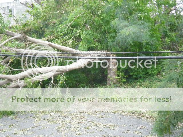