|
|
- - - 2022 Hurricane Season - - -
|
- CONSERVE - Not Just WATER -
|
- By Ian Martin Borde <readkrox51 at gmail.com>
- Date: Mon, 27 Mar 2023 11:55:19 -0400
|
Hi ! People of Paradise,
I see Avocados coming into Season. But my tree (the inverse usual with me). Looks like it needs to be cut down with woodlice.
We have Christian, Muslim and Hindi Feasts vying for Prayer and Fasting, ... Whether or Not, it's a colorful season for me. And this Easter should be more Colourful !
The reason being, The COVID Treath is much, much more Bearable, ...
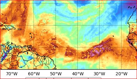
Weatherwise: It goes without saying, That we need to CONSERVE. And, NOT Just WATER.
The Barometric Pressures and SAL are a Mess. These climate conditions will still continue into the 'rainy' season.
Please Pay (without COVID) your Taxes and Dues, Gratefully. We are not organized, trained and equipped. To Do what The Authorities Do for US. [Hint: Poland] !!
[Quote: If in Doubt, read the Instructions.]
Standing By, Forever 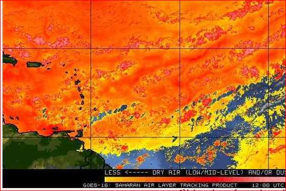
|
|
- ' Mother of all Carnivals ' - Monday & Tuesday Parade/Finale -
|
- By Ian Martin Borde <readkrox51 at gmail.com>
- Date: Mon, 20 Feb 2023 03:07:48 -0400
|
Tonight's 'Dimanche Gras' gives way to 'Jour Ouvert'. In this Theatre and Party, called Trinidad and Tobago Carnival, EVERYONE is 'Royalty, a King and a Queen'. EVERYONE is a Winner.
What started off as a Riot, during festivities, against 'Captain Baker'. Is now a Top Five foreign trade item. Martyrs died for this to take place. Not just 'Freedom' to express our Culture. But, The STAGING of what - Freedom - is all about?
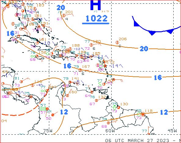
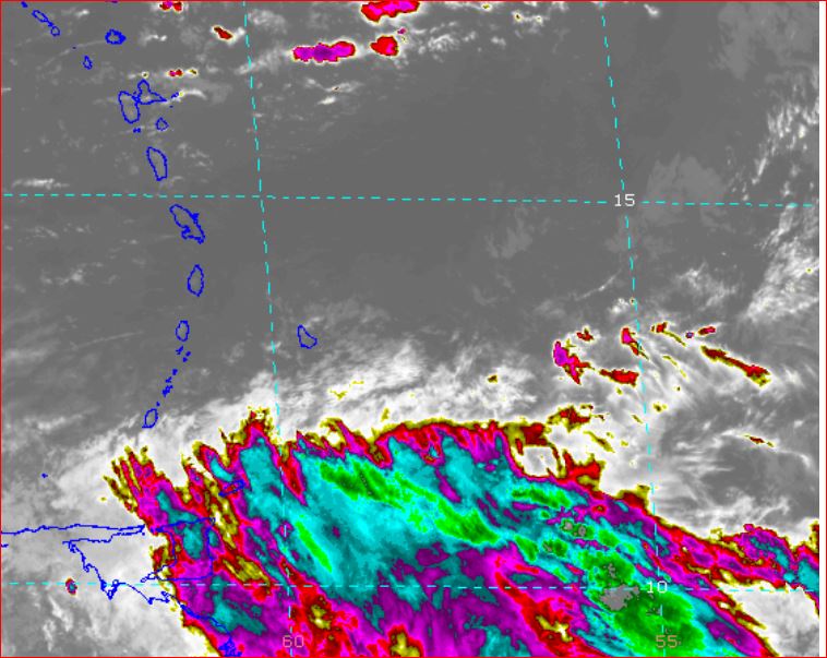
Weatherwise; The three usual factors to make more than Conventional Rainfall/Drizzle? Jet Stream and Wind Shear, Barometric Gradients, and SAL or Dry Air follows: Nothing Cyclonic can cross the Atlantic, is in the Gulf or the East Coast and Caribbean. Barometric thresholds to allow exit from the ITCZ is in Guyana almost Brazil. There is SAL past Trinidad almost in Guyana.
In short, any Rain to fall will be refreshing. [My take: Localized]. Security concerns are addressed by The New Police Commissioner. Food, Refreshments and Toilet Facilities are available. Because it is not an official holiday. But listen to 'Responsible Adults', not because the virus is still a threat. But, "for Your Own Personal Good!"
As for me, I'm off to the Greatest Street Theatre and Party, ....
See you next year, in God's Grace, . . . 


|
|
- Carnival - T'dad & T'bgo - Carnival -
|
- By Ian Martin Borde <readkrox51 at gmail.com>
- Date: Sun, 15 Jan 2023 13:14:54 -0400
|
The Trinidad Carnival has started in Earnest !
The Attached is a previous Carnival Sample.
Its hashtag (after COVID) - 2023 - is, ... ' The Mother of All Carnivals ' 
|
|
- * Happy Family Life in The New Year *
|
- By Ian Martin Borde <readkrox51 at gmail.com>
- Date: Sun, 1 Jan 2023 09:26:28 -0400
|
|
* Unity - P e a c e - Surplus *

|
|
- ALL The BEST -
|
- By Ian Martin Borde <readkrox51 at gmail.com>
- Date: Fri, 23 Dec 2022 11:23:35 -0400
|
" All The BEST for The Season "
* People of Paradise *
From: Ian and Madonna
-*Thanks!*- "Well Done!"
[The attachment is where we Celebrate, The Christmas Day, Thanksgiving Feast] 
|
|
- (smile) Hurricane Season - 'The Sequel' -
|
- By Ian Martin Borde <readkrox51 at gmail.com>
- Date: Sun, 4 Dec 2022 21:25:05 -0400
|
Battered People of Paradise, Struggling after COVID, to 'Make a Brighter World' for - Our Children -,
The ludicrous Title Caption, Hurricane Season - The Sequel, is to Draw Attention to maybe the BIGGEST FLAW in Relief Efforts. That is, - Outdated Methods of Analysis, ... - Including Disseminating Information, ... (Education, Learning, and Development).
Weatherwise, I did not make up the attachment. I did not predict the attachment. In NO WAY, did I alter the attachment.
It's there for you to see there will be at least more street flooding. Even if it's Sporadic and just bordering on one inch of precipitation an hour. IT WILL LAST MORE THAN 24 HOURS.
I didn't make this up. Much Better than me, Predicted this.
GOD! Please Bless 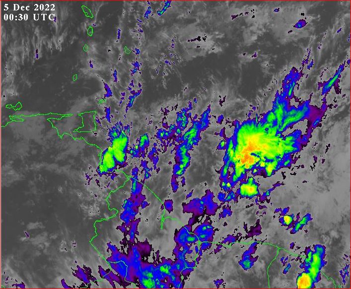

|
|
- What's in it for me!!! - Who's who and What's what?
|
- By Ian Martin Borde <readkrox51 at gmail.com>
- Date: Sun, 27 Nov 2022 00:04:48 -0400
|
People of Paradise,
Geographical Trinidad and Tobago is on - National Adverse Weather ALERT - (so far and rightly), till midday Monday !
Gov't has done and is doing far more than what I thought best! But, I would like to make three points for 'future' consideration?
The points are hidden in this anecdote, ...
"The very last 'FORMAL' Meeting I attended (and chaired). That was over seven years ago. I dissolved and abandoned it. Not just the Meeting but the Donation I instigated and was successful with.
A young starlet I had hoped would replace the old bridge. Before the meeting was abandoned. Kept asking, "How much of a cut each person wanted?"
Imagine if this meeting was for a heliport in Manzanilla/Mayaro?"
- End -
My friends, close, close family and friends, say every meeting is like that. Absolutely nobody in the meetings knows the who's who and what's what of fixing the problems, ... A New Year is coming, ...
God Bless
|
|
- T&T, - here we go, AGAIN !
|
- By Ian Martin Borde <readkrox51 at gmail.com>
- Date: Thu, 24 Nov 2022 10:56:42 -0400
|
|
|
|
- T&T - Huge TW, tonight and tomorrow -
|
- By Ian Martin Borde <readkrox51 at gmail.com>
- Date: Thu, 10 Nov 2022 13:35:11 -0400
|
Our Hearts go out to Post-'Dorian' Bahamas and 'Nicole'. Let us know and see. What little we can do, will be done.
Update: Trinidad and Tobago will experience a TW starting tonight/early morning. For now, its winds, waves and water are nothing Monumentally Disastrous. But very, very, very scientifically, not just thru emergency experience!!! It will have a hazardous effect, with damage control in geographical T&T!!! Not just Nariva, Tobago, Sangre Grande and Central!!!
I know we are STRESSED OUT over the Season.
Obey the second (2nd) Emergency Commandment?
The 1st is;- "Call for Help!" The 2nd is;- "Don't make a bad situation worse!!!!!"
GOD ! Please Bless 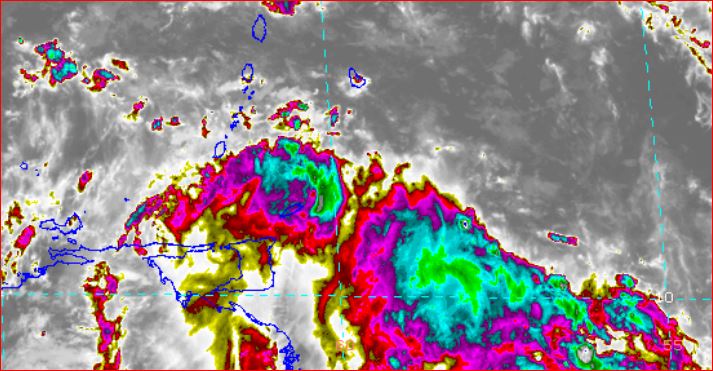
|
|
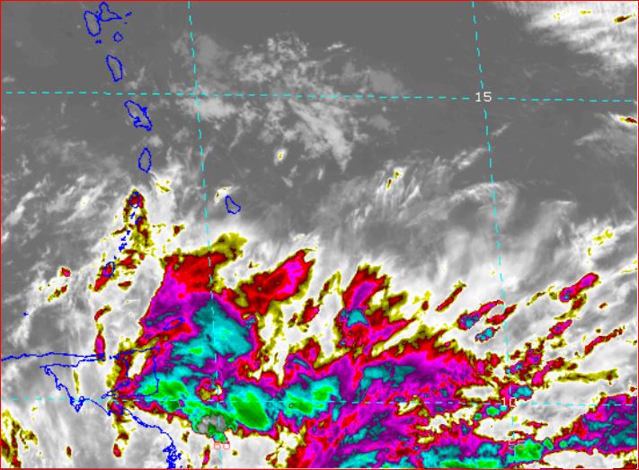
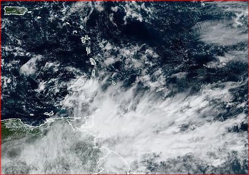
- Belize, (British) West Indies -
|
- By Ian Martin Borde <readkrox51 at gmail.com>
- Date: Tue, 1 Nov 2022 09:31:17 -0400
|
Belize, you're NOT FORGOTTEN.
The attachment has been filtered for 25mph. winds.
God Bless 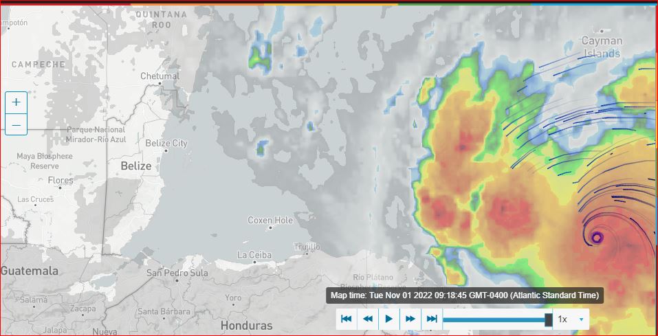
|
|
- Stand By !!!
|
- By Ian Martin Borde <readkrox51 at gmail.com>
- Date: Fri, 28 Oct 2022 00:59:50 -0400
|
All from NOW, there must be Damage Control ! Don't Sleep !!!
I praise and Bless the Authorities, ...
Stand By! for Damage Control, ... ... , from Tobago going forwards, ...
Stand By ! 
|
|
- TW is Here T&T !!
|
- By Ian Martin Borde <readkrox51 at gmail.com>
- Date: Sat, 22 Oct 2022 14:22:12 -0400
|
Hello to my Friends in Paradise,
Please don't forget Tobago has a Carnival of its own, ... Visit and Enjoy, ..., Freedom in Love and Nature, ...
A Tropical Wave has emerged from the WindShear.
The WindShear is bordering the east of us. The maximum Impact of the TW is still to the east of us. But it has arrived. With max. effect tomorrow morning, (wee hours till midday)!!!
Waves ; building to over six (06') feet. (overnight). Winds ; already 12 kms. - 18 kms. an hour. Water ; Building to over one (01") inch tomorrow, (overnight).
My Guess is, This TW is more than certain localities can sustain after the battering we had.this season!!
Don't let your guard down, ...
God Bless 


|
|
- 40 West and Water -
|
- By Ian Martin Borde <readkrox51 at gmail.com>
- Date: Tue, 11 Oct 2022 17:41:19 -0400
|
My Dearest People of Paradise,
I hope and pray , ... , I don't have to state the Obvious?
STAY AWAY from WATERWAYS and WATER COURSES, ... !!!!!
I see children (teenagers) playing in the mud during rain.
This OBVIOUS RESTRICTION is for a Long Time to come, ... !!
It's too much Water !
Besides the almost two weeks of precipitation T&T is having. There's a Tropical Wave embedded in the ITCZ coming. It will be HERE in less than three days!!!!
"How can warning systems and last minute systems/shopping stop people from Playing around with Hazardous Conditions?"
Education! All it needs is Education.
I fix my own bush-whacker and friends fix it for 'Free'. This is the first season it broke down (badly) without warning!!!
This is TOO MUCH WATER.


|
|
- More Precipitation Coming, ..., BUT! - ALL CLEAR -
|
- By Ian Martin Borde <readkrox51 at gmail.com>
- Date: Fri, 7 Oct 2022 05:09:54 -0400
|
- Empower Yourself - In The Name of The Highest 
|
|
- DEFINITELY - NO - ALL - CLEAR, ... , Standing By , . . .
|
- By Ian Martin Borde <readkrox51 at gmail.com>
- Date: Wed, 5 Oct 2022 21:46:59 -0400
|
Pray !!!
Already a Lady is Missing. ( Hours and Witnesssed !!! ) "That in itself puts us overnight in an islandwide Emergency situation. Pray !!!!!" 2) The formative Centre of Circulation wobbled and wobbled from 4:00 am in the pre-dawn morning. Until it stayed from 08:00am, (8:50pm at the time of beginning writing, ...) for over 12 hours with constant precipitation and gusty breezes south west of Grenada and northwest of the Gulf of Paria. That in itself signifies a Hazardous situation. 3) As per Dominica, that will be called cyclogenesis. The South American coast is stopping it and the shallow (warm waters) are boosting it. NOW! Permit me to Thank Jane for tipping me back to posting. And OUTSTANDINGLY Jurgen from Bim and the BMS for a continuation of Brotherly Love and Hardwork, ... 4) Nobody knows, but the 30% or less chance it rains tonight or even tomorrow. Will cause any living thing with a heart to help out and in my case, stand by. I already said in this post. Without tonight and tomorrow precipitation, we should be in emergency mode. 5) I am slightly moved to see how much people I affect and I apologise for not writing before.
pray, pray, pray, ... 
|
|
- Tropical wave effects
|
- By Adesh Nanan <adeshcnanan at gmail.com>
- Date: Wed, 5 Oct 2022 13:07:56 -0400
|
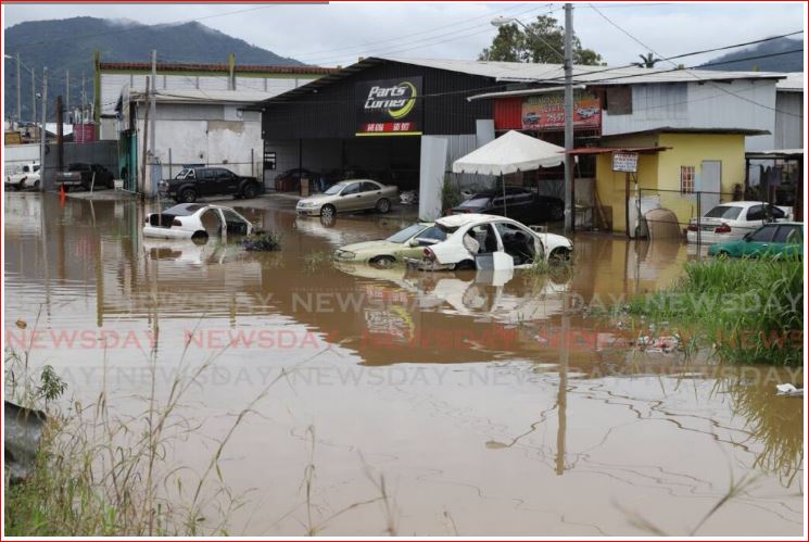
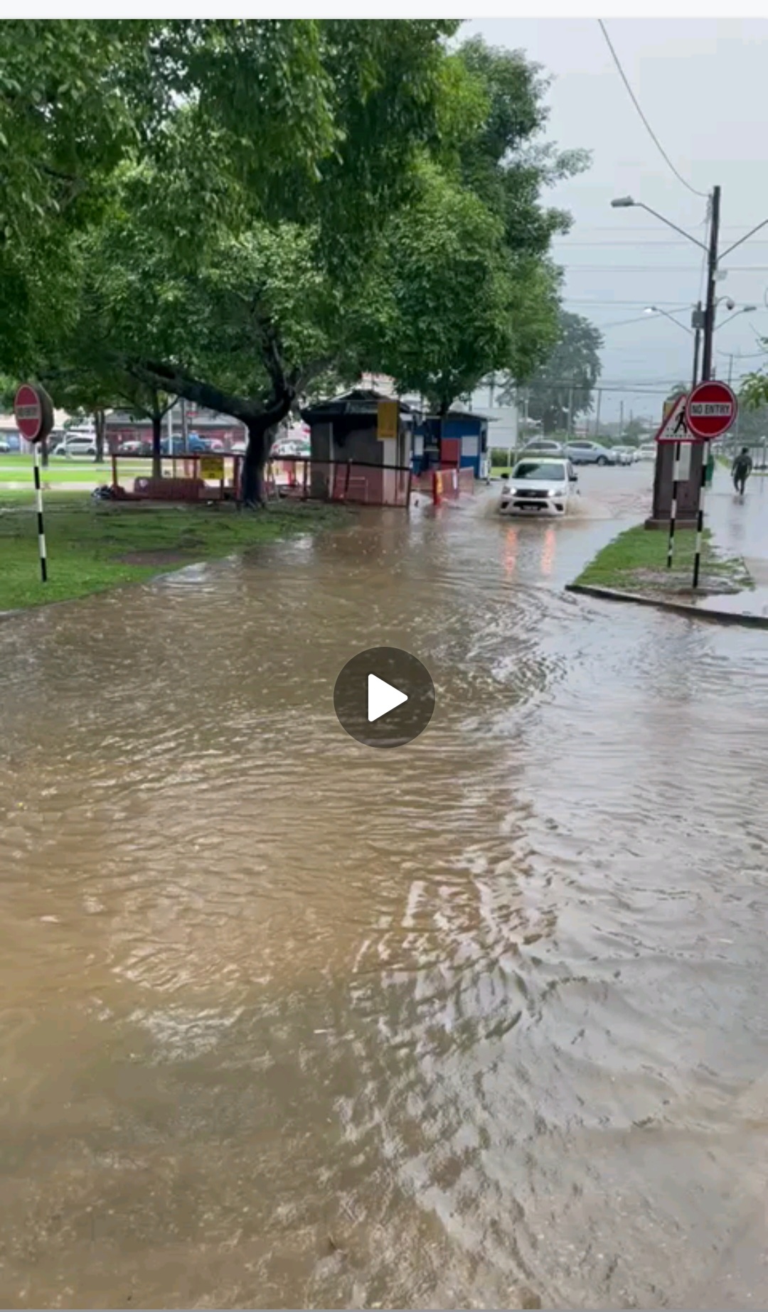
Dear Gert This is severe flooding pics of UWI St Augustine in the aftermath of heavy thundershowers in the east of the island. Rivers were overflowing due to the volume of rainfall. 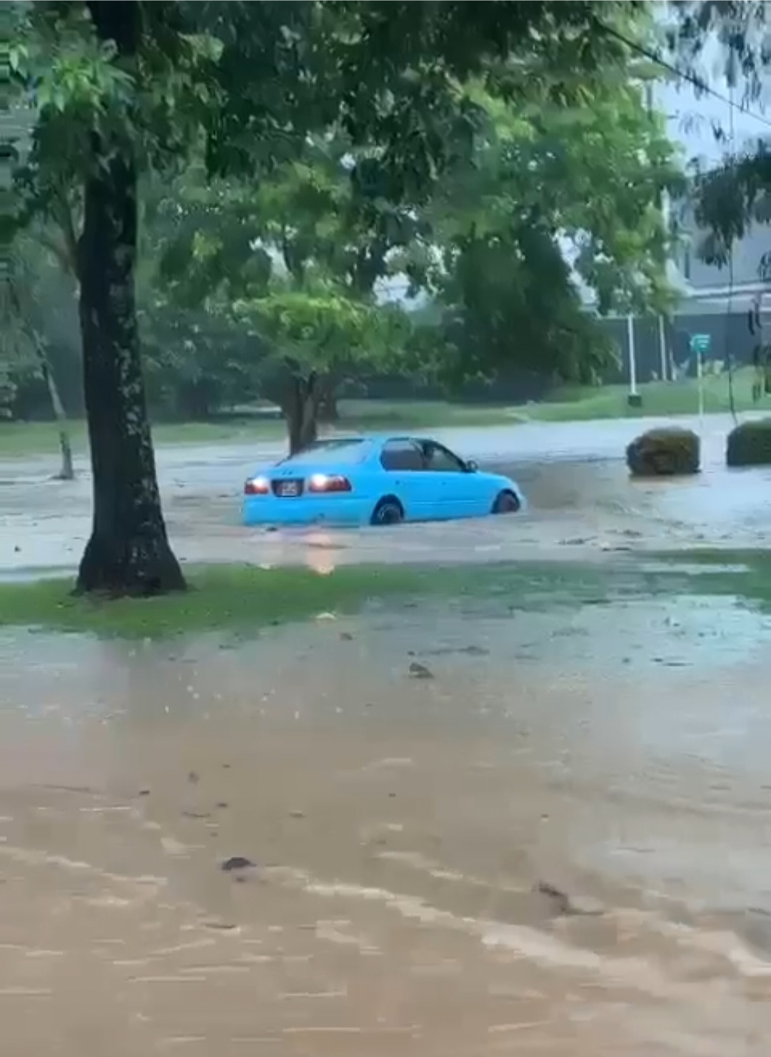
|
|
- Tropical wave : Flash flooding
|
- By Adesh Nanan <adeshcnanan at gmail.com>
- Date: Wed, 5 Oct 2022 12:51:09 -0400
|
Dear Gert Update of flash flooding in UWI St Augustine Trinidad Attachment:
VID-20221005-WA0019(1).mp4
Description: video/mp4
|
|
- Strong Tropical wave
|
- By Adesh Nanan <adeshcnanan at gmail.com>
- Date: Wed, 5 Oct 2022 12:26:14 -0400
|
Dear Gert, Presently there is thunder overhead with persistent rainfall in Palmiste San Fernando.There are reports of intense thundershowers in the east resulting in severe flash flooding.The University of the West Indies in St Augustine is flooded out and students are marooned at this time.
Attachment:
VID-20221005-WA0019(1).mp4
Description: video/mp4
|
|
- LPS > 36 Hours
|
- By Ian Martin Borde <readkrox51 at gmail.com>
- Date: Mon, 3 Oct 2022 12:15:33 -0400
|
I don't know where I got time to write this post. "We need the next generation to come forward, ... "
Here goes; There's a TW that exited the ITCZ at 11:00am today. It exited the ITCZ with High-Level Circulation. Soon-to-be; Low-Level Circulation. The 'Axis' exited at 50 West. (Max. barely a Depression). Because there is NO SAL, if it stalls; There will be more than one inch of rain an hour. My take is!!! "It's heading for Dominica and Martinique".
stormcarib has become a 'Responsibility' for me at the age of sixty-four (64yrs.). I will love to see the younger generation take over from me?
God Bless 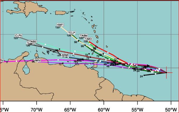
|
|
- Rest in Peace, Ronnie Lockhart, . . .
|
- By Ian Martin Borde <readkrox51 at gmail.com>
- Date: Sun, 2 Oct 2022 01:39:37 -0400
|
|
|
|
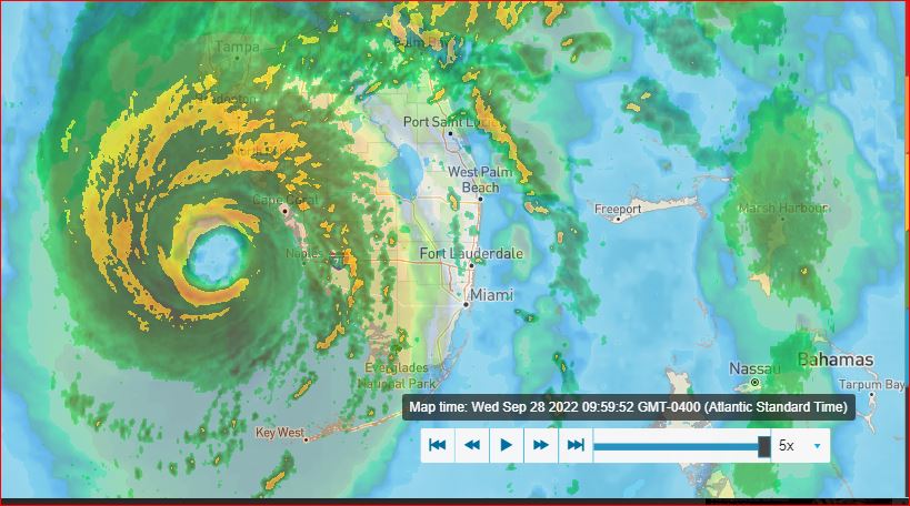
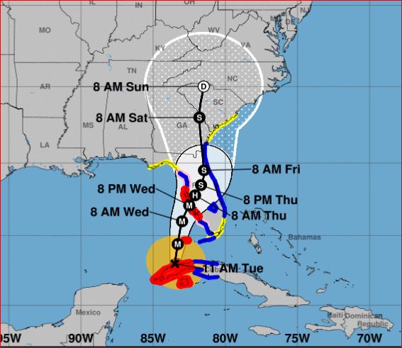
- Centre of Circulation Landfall - 'Ian' 09:30am - Part III
|
- By Ian Martin Borde <readkrox51 at gmail.com>
- Date: Wed, 28 Sep 2022 10:12:12 -0400
|
PRAY, ...
One map is filtered for 60 mph. winds and greater, ... Another is filtered for 40 mph. winds and greater, ...
Just read the map, everything is there. I don't want to say much more.
Except That, the Washington Post is on Spot and on Point !!!!!
Pray 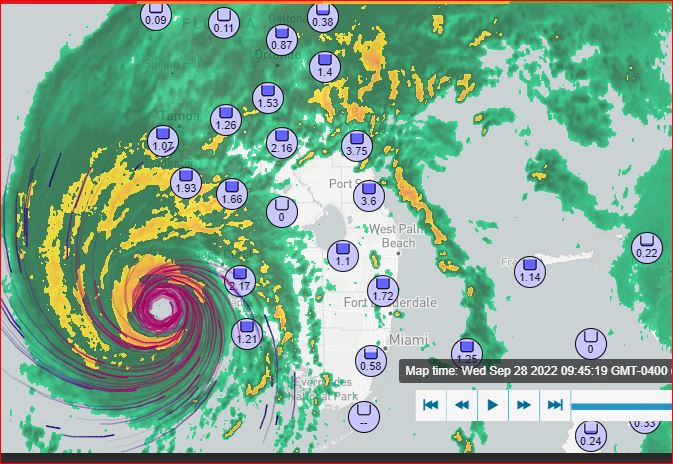
|
|
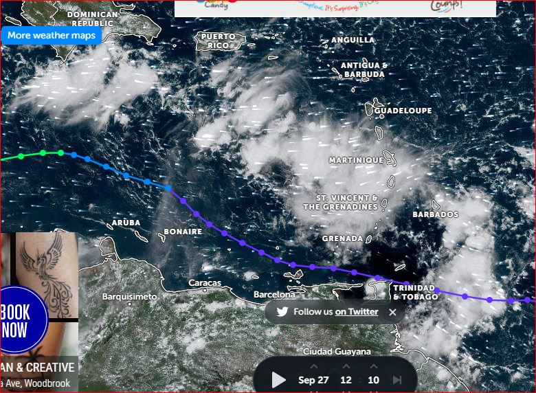
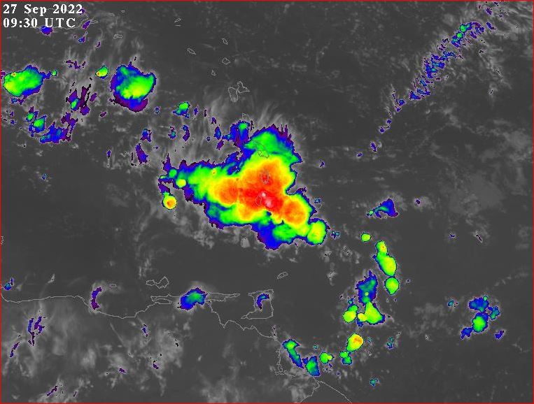
- Standing By 2022-09-27th - 29th Part II
|
- By Ian Martin Borde <readkrox51 at gmail.com>
- Date: Tue, 27 Sep 2022 12:52:08 -0400
|
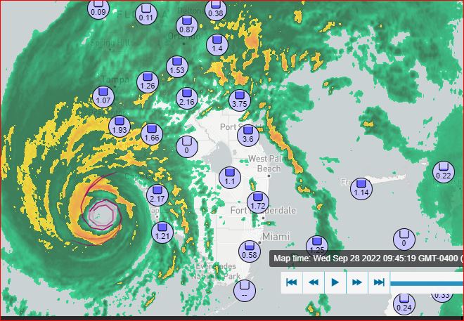
|
The worse is yet to come.
|
|
- Standing By, ... !!
|
- By Ian Martin Borde <readkrox51 at gmail.com>
- Date: Tue, 27 Sep 2022 06:15:40 -0400
|
Standing By! for, St. Lucia and St. Vincent !!
Any and Every thing, ... Except cash.
By the Way !!!! Yesterday was Oct. 2022 - Sept.2023 Budget Day !
Complacency Kills 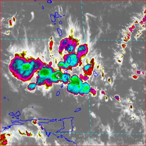
|
|
- Commendable Mobilization , . . . -
|
- By Ian Martin Borde <readkrox51 at gmail.com>
- Date: Mon, 26 Sep 2022 12:52:05 -0400
|
My Dear People of Paradise, and Not just 1st. Responders !
For the recent Past, the Present Time and Medium-Term Future, Your Mobilization is above most people's Expectations, . . . It is Highly Commendable to see; Old and New Fashioned, High and Low Technology, Disadvantaged and Affluent, W o r k ! In preventing Disaster Situations getting Worse.
For those who do not 'know the drill' ? It's Prep and Rest ! Prep and Rest ! then Prep A G A I N ! 
|
|
- Use Your Heart & Your Head but Work with Authorities, ...
|
- By Ian Martin Borde <readkrox51 at gmail.com>
- Date: Mon, 19 Sep 2022 03:42:46 -0400
|
In case you're wondering, ... ?
I am very much awake. I have been standing by throughout, ... And will continue, ...
One of the first things we learn, ... !!!!!!! Work with the Authorities !!!!!!!
You won't believe ! How negative and frustrating it is !!! Hearing criticisms and complaints and disobedience to SUPERIOR COMMON SENSE !!!!!!!
" Work with the Authorities !"
and, "Please accept our Condolences and Prayers, ... "
God is Blessing, right Here and Now 
|
|
- Standing By! (Whole Night) -
|
- By Ian Martin Borde <readkrox51 at gmail.com>
- Date: Sat, 17 Sep 2022 23:04:55 -0400
|
Notres Supplications aux Freres en Guadeloupe, . . . C'est meilleur d'envoyer des informations ici.
Oraciones a hermanos nuestros en Puerto Rico, ... Ponen importancia de enviar noticias aqui, ...
Our Prayers go out to Isabel and St. Croix, ... Keep (as long as it is possible), posting here, ...
My People are Here with me Here.
- E V A C U A T E -

|
|
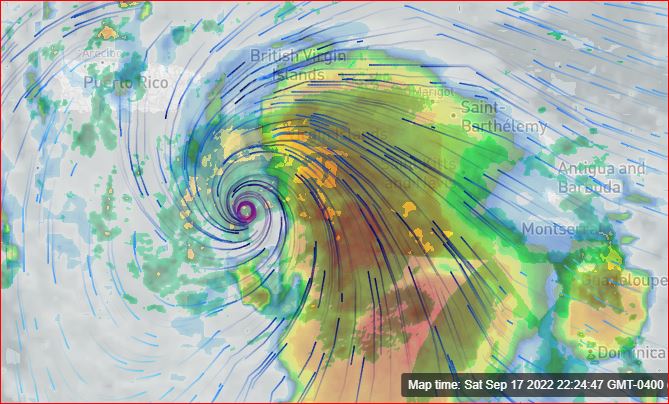
- Direct Impact of Centre of Circulation on Guadeloupe at 7:00pm. -
|
- By Ian Martin Borde <readkrox51 at gmail.com>
- Date: Fri, 16 Sep 2022 19:52:06 -0400
|
The Bottom Line 1st. !!!!!!! The Point 1st. ;
"Even Trinidad (and Tobago) who will be on STANDBY. My experience of Emergency Work. The Authorities Storm Forecasts. The HIGHLY POTENT POINT of Climate Change.
Rainfall (in the tail) will. Even in T&T. Will Be over 3" inches for a minimum of two days.
The Point is, ... , Emergency Work will be Hampered after the Winds. "
"The aftermath is an Emergency Situation".
If you are NOT TRAINED and Equipped, - EVACUATE - !!!
The Direct Centre passed Directly over Guadeloupe. What more do you need to save lifes? A Seance? An Obiturary?
Evacuate |
|
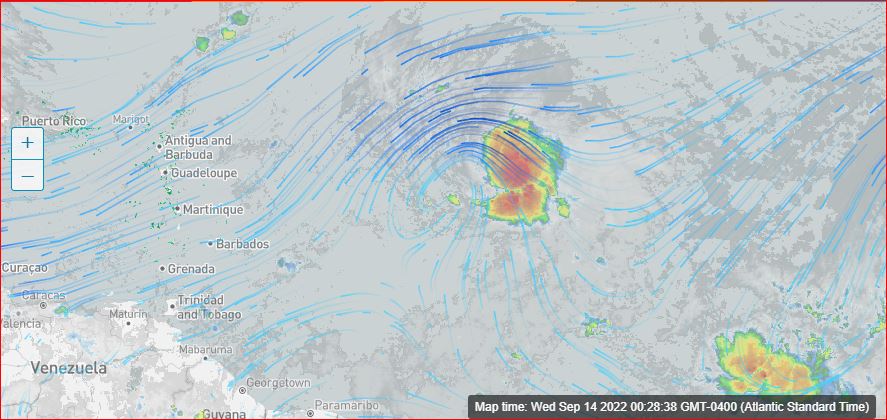
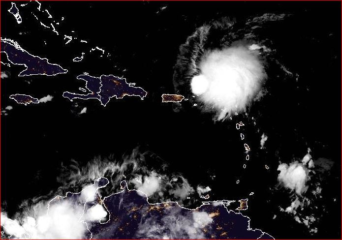
- 2022-09-14th Wednesday 00:40am. - 1st Look -
|
- By Ian Martin Borde <readkrox51 at gmail.com>
- Date: Wed, 14 Sep 2022 00:40:33 -0400
|
|
- Prepare and GOD Bless -
|
|
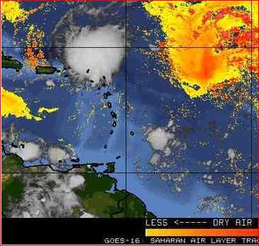
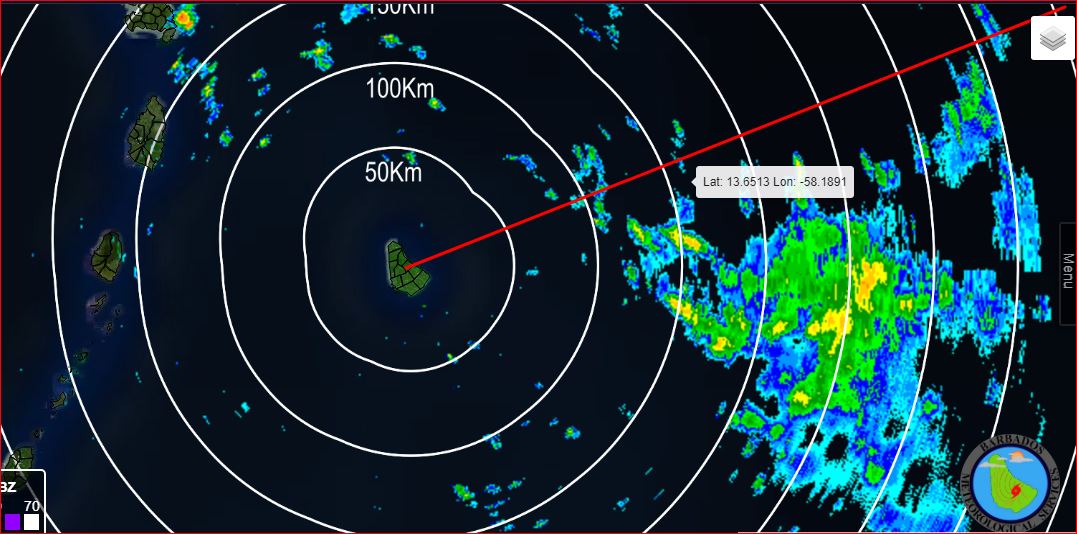
- Hazardous Trough for Eastern Caribbean (momentarily) -
|
- By Ian Martin Borde <readkrox51 at gmail.com>
- Date: Sun, 4 Sep 2022 04:43:53 -0400
|
People of Paradise in Barbados and the Eastern Caribbean, which includes T'dad & T'bgo,
The ITCZ or Monsoon System has reached the Latitude of Hurricane Season. For the new readers, that means LPS Systems don't have to come from Africa ONLY.
As the ensuing case in Point. ( With attached Graphics, ... ) !!!!
By the way, can my esteemed friend Dave or someone else. Indicate to me the circular winds without precipitation for now over two days over the Cayman Islands, ... ?
Back to the ITCZ Trough embedded in the 10 North ITCZ? Moisture and Precipitation Graphical Illustrations say it bears way more than one inch of rain an hour and can last in some islands for three days.
Another Aside and Gentle Reminder? "More than one inch of rain an hour can kill someone with their guard down".
God Bless
|
|
- 2022-09-03rd 06:30am - Update -
|
- By Ian Martin Borde <readkrox51 at gmail.com>
- Date: Sat, 3 Sep 2022 07:28:05 -0400
|
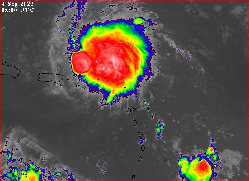
I DEFINITELY Don't like two things, ...
How slow 'Earl' is moving! How the 'Dry Air' is clearing!!!!
Aside: It's almost creaturelike; The Centre of Circulation leaves the Precipitation. Clears the SAL and goes back where he comes from.
More things are wrought by Pray. Than any Act of any Human. 
|
|
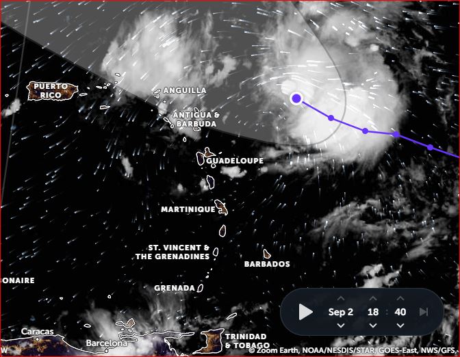
- Landfall IMMINENT Tonight -
|
- By Ian Martin Borde <readkrox51 at gmail.com>
- Date: Fri, 2 Sep 2022 19:23:16 -0400
|
People of Paradise, From Martinique to Puerto Rico,
It dipped South.
The Centre of Circulation has already entered the Leewards.
Landfall is Imminent Tonight. But, Breezes are less than 35mph.
Do your Best, God will do the rest, ... 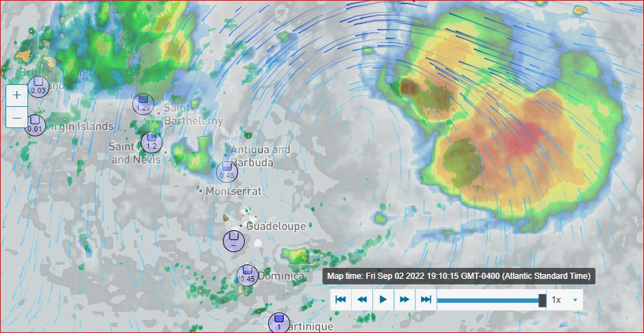
|
|
- 2022-08-24th Wed. 2:25pm - Update -
|
- By Ian Martin Borde <readkrox51 at gmail.com>
- Date: Wed, 24 Aug 2022 14:44:08 -0400
|
Don't Last Minute Prepare, ....
Prepare for the Season, People of Paradise!!!!
Thanks to Jurgen from Barbados!!! The attached shows the following:
It speeded up. It Dipped South. (towards Land & High Pressure). It has a Centre of Circulation, east south-east of Mayaro!! The Centre of Circulation is Surrounded by Moisture, ... !!! Winds in the Centre of Circulation are no more than 17kms. an hour. (for now). Landfall can be expected tonight/tomorrow as a long-lasting TW Thunderstorm.
NOBODY knows. Absolutely Nobody knows when a Disaster will occur?
Forget the Graphics and last-minute preparations and money-making ventures. Stay away from Rivers and Beaches! Marine Crafts should come ASHORE! WATER ! Stockup on WATER !!!!! Service Emergency Machinery, Medicines and Basic Essentials. Including Documents!!! Ask for HELP, ... (See about the less fortunate?) Ready Emergency Contacts for Emergency Personnel, ...
Treat it like, ... , a long-lastingTropical Wave. 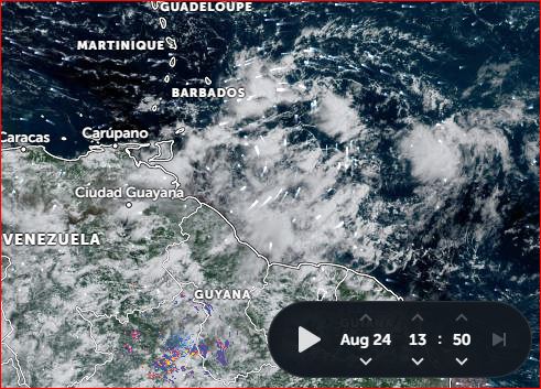
|
|
- High-Level Circulation exited the ITCZ! 2 - 3 Days away -
|
- By Ian Martin Borde <readkrox51 at gmail.com>
- Date: Wed, 24 Aug 2022 04:48:22 -0400
|
People of Paradise, Prepare !!
Basic Instinct:
Caribbean People of Paradise, Please Prepare, ... ... , NOT JUST for this Weekend !! But, for the Season, ...
Emergency Procedures are Basic Survival Instinct! - It keeps you Healthy. - It gives YOU Long-Life. - It SAVES Money. and when you get GOOd at it. - It makes you better off, Financially !!! It's Not Paranoia and Baseless. Climate Change is Real !
I had a lot to say about this Low-Pressure System this Weekend. But it was a bit sickening to see the climax to these systems. Culminating in a 'Freak' Storm Monday in Trinidad.
Para-Military Training comes in handy. As the anti-climax to the usurpers gives way to the National Hurricane Centre, ... !!!
Please Prepare 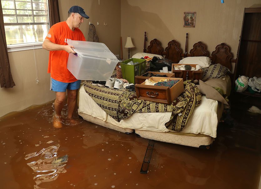
|
|
- ... , Just a TW, But , ... !!! -
|
- By Ian Martin Borde <readkrox51 at gmail.com>
- Date: Sun, 14 Aug 2022 07:58:30 -0400
|
I had the time but started late. This needs a good look and analysis. Trying to say, I'm busy. But I will be able to do so after 4:00pm. today. My daughter returned home three weeks ago.
This TW 'Blob' appeared out of nowhere. While the former mid-Atlantic Depression dispersed north of the Eastern Caribbean.
My early take? It's grandiose and resembles 'Bonnie' in its early stage. It's due West on West. It's Ominous.
Complacency Kills 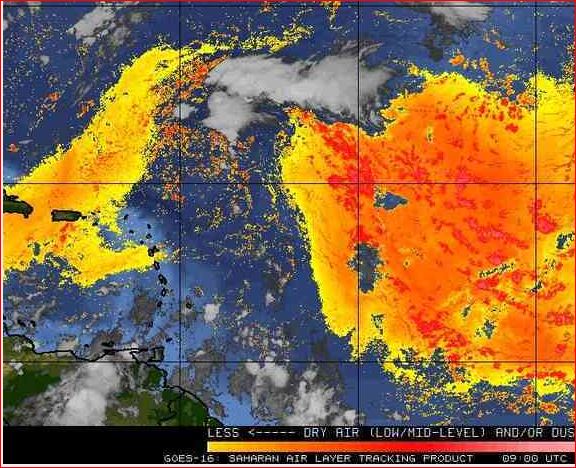
|
|
- Private Sector getting Involved -
|
- By Ian Martin Borde <readkrox51 at gmail.com>
- Date: Thu, 11 Aug 2022 22:30:38 -0400
|
This is one of many needed examples of the increased role of the Private Sector in the continuation of T&T Development.
Please God! No more tribal drums.

|
|
- Some Suspense is Over -
|
- By Ian Martin Borde <readkrox51 at gmail.com>
- Date: Sun, 31 Jul 2022 06:58:43 -0400
|
"This is a Partial, - 'All-Clear'."
Sorry! Pressed the wrong button.
The TW/LPS is over the southern Windwards now. Nothing Emergency Personnel cannot handle. It dipped 'REALLY' South, .... My take is; It's going to 'crash' into Latin-America at some point. It's moving really fast. No time to build up. Stay away from rivers.
God Thanks 
|
|
- Some Suspense is Over -
|
- By Ian Martin Borde <readkrox51 at gmail.com>
- Date: Sun, 31 Jul 2022 06:50:43 -0400
|
|
This is a Partial, - 'All-Clear'.
|
|
- 40 West and its 20/20 Insights -
|
- By Ian Martin Borde <readkrox51 at gmail.com>
- Date: Fri, 29 Jul 2022 09:55:54 -0400
|
Hi, People of Paradise!
I have three rotten tyres on the vehicle to fix this morning. So! Just a short Post.
There is 'Nascent' Circulation at 40 West.
The most Important Hazard Prevention Point, at this moment?
The 'History' of 2022 LPs are, 'Due West on West' !!!!
God Bless 
|
|
- Thunderstorms Tomorrow - No Circulation -
|
- By Ian Martin Borde <readkrox51 at gmail.com>
- Date: Sat, 16 Jul 2022 11:42:04 -0400
|
Thunderstorms slightly more organized than what Trinidad had. Are affecting Barbados right now. The axis will go through, Grenada and St. Vincent late tonight, more tomorrow. But, the 'Blob' stretches from St. Lucia to south Trinidad, ....
It took a dip 'South'. Was Heading for Dominica.
God Bless 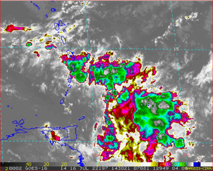
|
|
- There is NO Circulation -
|
- By Ian Martin Borde <readkrox51 at gmail.com>
- Date: Fri, 15 Jul 2022 08:08:07 -0400
|
Good Morning, People of Paradise!!
This is normal weather. This is normal heat and pressure. This 'Blob' has NO Circulation.
However !!! Having that Generalisation in mind. And Knowing it's going to end soon.
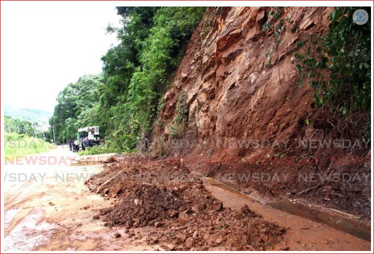
Based on the Landfall of what became 'Bonnie'. The Nariva area cannot recover properly. Based on all satellite images so far.
A guesstimate is a more MEDIUM-TERM AMELIORATION.
For the Easern Caribbean, ...
The Pressure Gradient for the Northward Swing of Cyclones. Has shifted more North. But only Inches, ... !!! and, Larger Systems than what Trinidad is having are Due West on West.
Stay Blessed 
|
|
- 2nd. (Potential) TW Blob - 2022-07-01st. Fri. 10:30am -
|
- By Ian Martin Borde <readkrox51 at gmail.com>
- Date: Fri, 1 Jul 2022 11:07:44 -0400
|
Hi, People of Paradise!!!
I'm still very much 'under-the-weather'. But, Circulation, (probably High-Level), Circulation has started off St. Lucia. At 10:30am. today it is due East of Martinique. That is the Wave Axis. My Take: I see it passing into Martinique, Dominica and Guadeloupe this Evening. The Leewards and Virgin Islands later than that but tonight. For the Windwards finishing by Sunrise. Nobody knows what will happen tonight. But right now, there is NO low-level Circulation.
[Aside]: have wind, wave and precipitation Data. (Buoys and Marine Crafts).
It's the EARLIEST THING that saves Lifes. Reduces Insurance.
Going into Port of Spain, eat lunch and go back to sleep. My daughter is returning within 21 days after more than 5 years.
GOD Bless 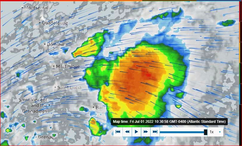
|
|
- Trinidad in a tail spin!
|
- By Adesh Nanan <adeshcnanan at gmail.com>
- Date: Wed, 29 Jun 2022 18:50:55 -0400
|
Dear Gert, There is thunder rolling overhead and lightning discharges in the Gulf.There has been a light shower in Palmiste San Fernando but in certain parts of the island there are reports of heavy rainfall
|
|
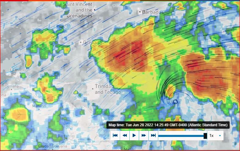
- 2022-06-28th Tue. 11:00pm - snippet (iii) Final for 'Bonnie' & TnT-
|
- By Ian Martin Borde <readkrox51 at gmail.com>
- Date: Tue, 28 Jun 2022 23:19:26 -0400
|
Okay, People of Paradise ?
We have the Precipitation to deal with now. For a select few. That's until tomorrow evening. For the Majority, it's until Thursday night.
An ameuter like me, will guess that's a comfortable 3" inches. Whether comfortable or not, we came out better than expected.
In order of looking forward to 'restitution and restoration' ? This ameuter suspects, Tobago, South Trinidad, Grenada, Toco/Sangre Grande Chaguanas (In that order), Have the most to Report, Post-Mortem and Teamwork with !!!!
I need to pray and take a rest, ...
GOD Bless (No all Clear as Yet!) 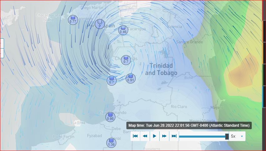
|
|
- Nariva Swamp Landfall at 8:25pm - snippet (ii) -
|
- By Ian Martin Borde <readkrox51 at gmail.com>
- Date: Tue, 28 Jun 2022 21:07:31 -0400
|
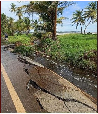
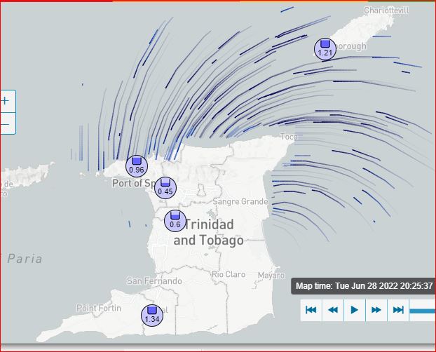
- T'dad & T'bgo, meaning from east in Tobago, to Nariva, to Pt. Lisas, then to 'Down the Islands', back to Tobago is encompassed in TD winds (>25mph.). - The north and east coasts are getting battered (37mph. winds). Not so much Tobago anymore. - Grenada had over 3" inches of rain presently. Please read the images. Our details with time are there. - Soon-to-be 'Bonnie' made landfall in Nariva Swamp at 8:25pm. As you can see ? Now for three (03") ins. of rain.
Thank GOD 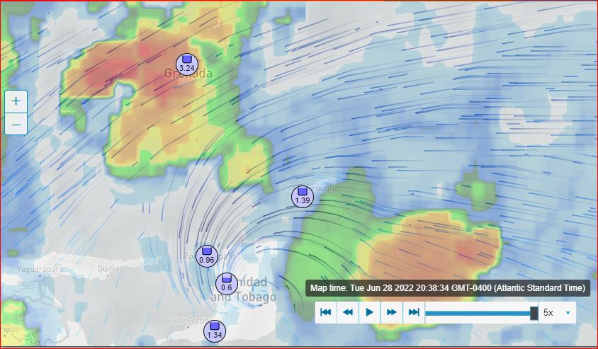
|
|
- 2022-06-28th. Tue. 7:00pm - Snippet (i) -
|
- By Ian Martin Borde <readkrox51 at gmail.com>
- Date: Tue, 28 Jun 2022 19:48:56 -0400
|
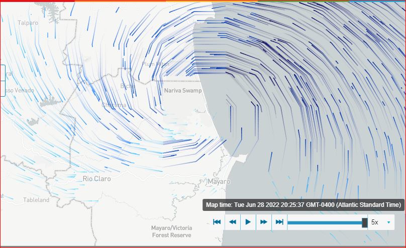
- The outer bands of the Centre of Circulation encompass Tobago with barely 25mph. winds. - Touching Toco with 20mph. winds.
- The Centre of Circulation (40mph. winds) will be North of Guyaguyare. - It is due East of The Mayaro/Victoria Forest Reserve. - That means its least Trajectory will be above Mayaro on Landfall. (Probably much better than that!). - The southern half of the Centre of Circulation has no discernible hazardous winds, ... - An example of the southern half's measurement is Mayaro to the tip of Trinidad.
(Will be back VERY Shortly). 
|
|
- 30 mins for effects
|
- By Adesh Nanan <adeshcnanan at gmail.com>
- Date: Tue, 28 Jun 2022 17:35:03 -0400
|
Dear Gert We are 30 mins away from projected heavy rainfall and winds.At present in Palmiste San Fernando ,there is a slight shower with thunder in the distance.Humidity is very high and a cold wind is blowing.
Dr Adesh Nanan |
|
- Centre of Circulation in 3 - 6 hours -
|
- By Ian Martin Borde <readkrox51 at gmail.com>
- Date: Tue, 28 Jun 2022 14:55:31 -0400
|
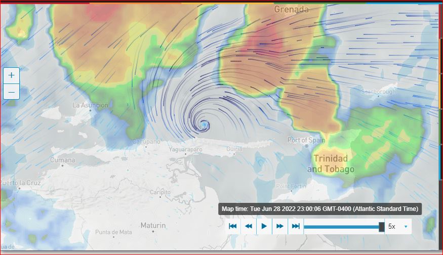
In case you haven't yet !
Get Indoors Get off the streets Evacuate if Necessary
It will take a Super, Supernatural Force for the Centre of Circulation not to pass directly over Trinidad & Tobago in 3 - 6 hours.
Tobago is having about 03" inches of rain.
In Jesus Name, Have Mercy ! 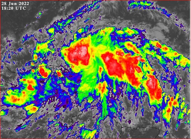
|
|
- 2022-06-28th Tue. 10:25am - Update -
|
- By Ian Martin Borde <readkrox51 at gmail.com>
- Date: Tue, 28 Jun 2022 10:44:22 -0400
|
* [Correction: northeast quadrant is as image below.]
The entire East Coast of Trinidad has 20mph. winds. Tobago is covered in 20mph. winds.
Don't let the northern Sector of the LPS fool you. The Centre of Circulation is still East of Trinidad. According to the officals, less than 320 kms away.
Finally; The image below is filtered with winds greater than 25mph.
God Bless 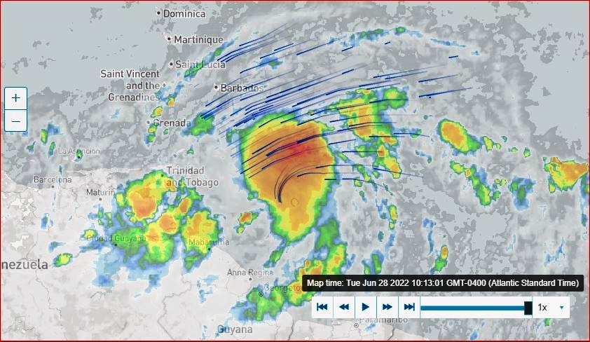
|
|
- Thunder rolling overhead
|
- By Adesh Nanan <adeshcnanan at gmail.com>
- Date: Tue, 28 Jun 2022 10:39:54 -0400
|
Dear Gert Presently high winds and heavy rainfall...maybe a squall in Palmiste San Fernando
Dr Adesh Nanan
|
|
- 2022-06-28th Tue. 05:55am - Touchdown -
|
- By Ian Martin Borde <readkrox51 at gmail.com>
- Date: Tue, 28 Jun 2022 06:15:03 -0400
|
Thanks, Isabel ! Thanks, Gert ! Thanks, Dave ! Thanks, Fellow Correspondents, ... ! Thanks, Donors ! Thanks, Everyone , ... !
There will be a lot of mangoes on the ground afterwards!
People of Paradise,
No storm precipitation , ... , but Tobago has 20 mph. Depression to-be-Storm Winds. Grenada you are going to feel the winds. Stretching a little less than 200 miles in the Northeast Quadrant are 30 - 40 mph. winds. Mayaro/Manzanilla has 10 - 15 mph. winds but 'storm-precipitation'. The smallest 'Hazard' Reality is (T'dad & T'bgo) rain for five (05) days.
As for 1st. Responders, ... - Their Safety comes First. Respect them. They are HIGHLY Trained and Equipped. - Comply!!! Don't Criticize and Complain. - a) They have left their family, b) risking their lifes, c) to assist you.
"Don't blame anybody but yourself". GOD Bless 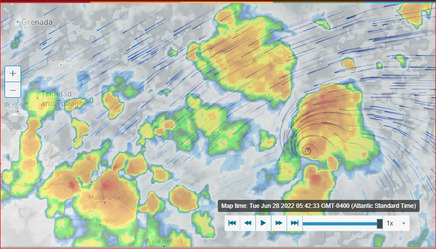
|
|
- Tropical Storm on our Doorstep
|
- By Adesh Nanan <adeshcnanan at gmail.com>
- Date: Mon, 27 Jun 2022 21:33:25 -0400
|
Dear Gert, The twin island republic has begun preparation for the approaching system. The Disaster Management unit in each of the 14 Regional Corporations in Trinidad are in a heightened state of alert distributing sandbags and opening certain selective shelters. Over in Tobago there is a similar sense of urgency. If this is a dry run, I must give the authorities a thumbs up!
Dr Adesh Nanan
|
|
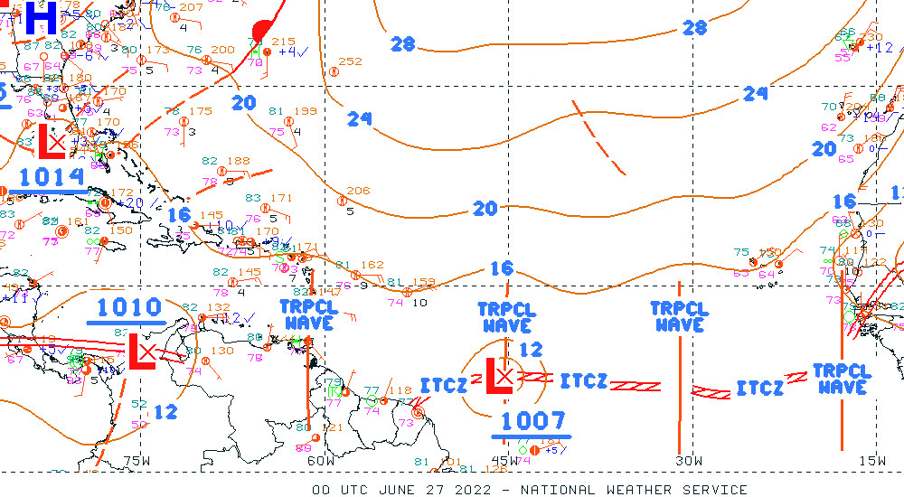
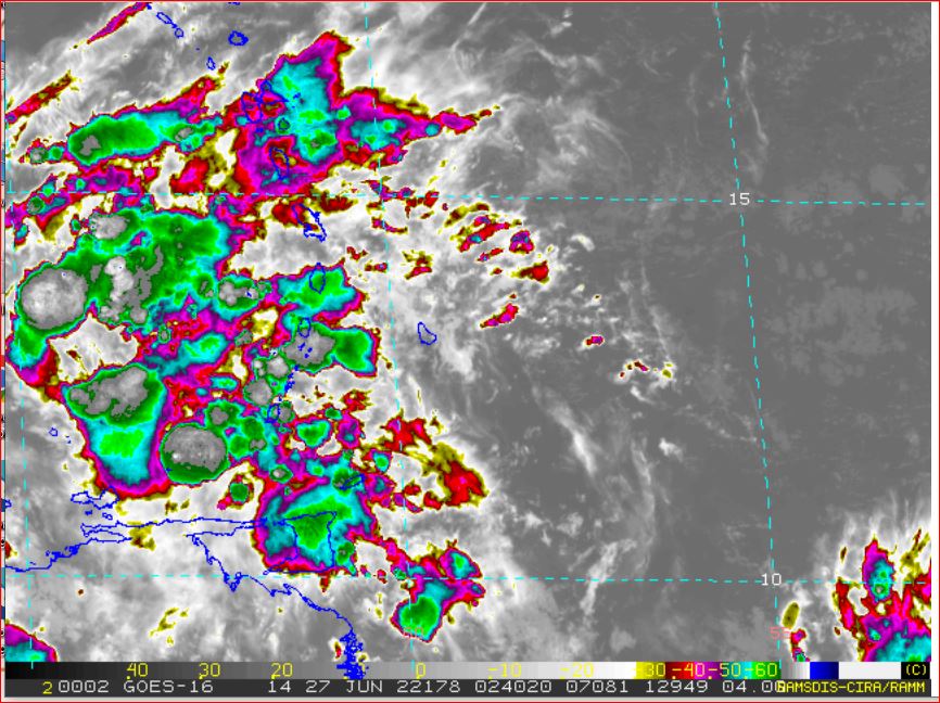
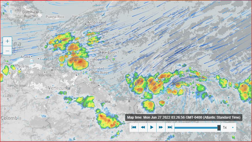
- 2022-06-27thMon. 01:45 - 03:45 am. - Update -
|
- By Ian Martin Borde <readkrox51 at gmail.com>
- Date: Mon, 27 Jun 2022 04:38:22 -0400
|
- It's too early and dangerous for a Post-Mortem. - This Post is going to be Long. So un-scientific readers will be turned off. All of this Post can be summed up in the next Post, right after. - If you look at the satellite details. The rain clouds from the 1st LPS merge with the 2nd. LPS.
a) At 01:45am. the (redundant, dispersed, former) Centre of Circulation of the 1st. LPS was in the area of Maturin, Venezuela. Quite West of Trinidad, BUT TRINIDAD WAS HAVING RAIN. A new Centre of Circulation will form somewhere West of the Windwards between 12 - 16 prevalent Isobars. The former Centre was heading for Caracas,
Venezuela at 03:45am. b) The Centres of Circulation in these Tropical Climate Change Low Pressure Systems are surrounded by approximately 1,500 nautical miles of a Cone of Uncertainty. (Or Danger). That means : Rain; more than two (02") inches in an hour. Wind; over 25mph. fairly consistently, ... Seas; Stormsurge and waves over 6' feet. 3) Last, but the reason for this particular post. (In terms of Alertness. Which I can't seem to retire from.) The rain clouds affecting the Windwards. [see: East of Barbados and Trinidad] Will show that the 1st. LPS merges with the 2nd. LPS. I can't remember the time. (Four hours of Research). But the Centre of Circulation for the 2nd. LPS. Is barely within 50 West and 10 North.
GOD Bless 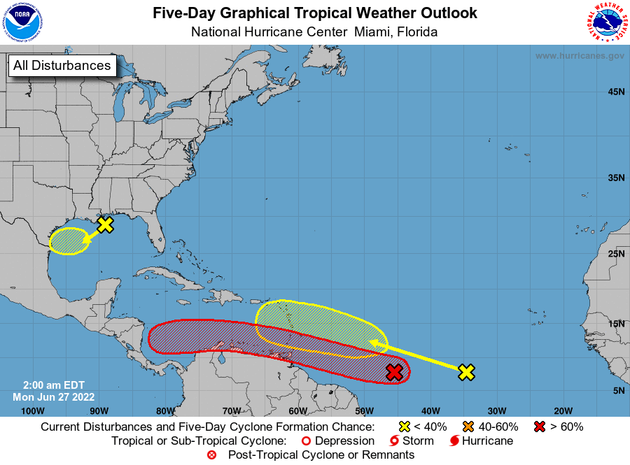

|
|
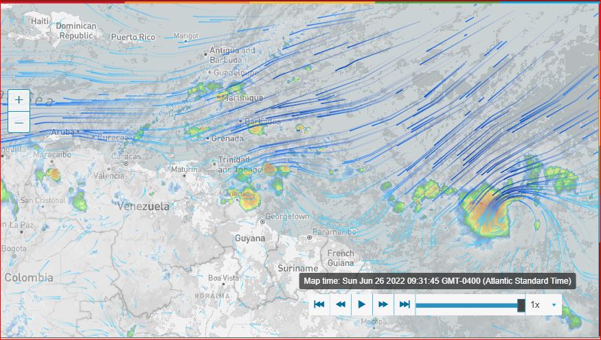
- 2022-06-26th Sun. 4:30pm - Bad, Bad, News !!!
|
- By Ian Martin Borde <readkrox51 at gmail.com>
- Date: Sun, 26 Jun 2022 16:37:29 -0400
|
I am interrupting my research and posts. To tell you, "The 1st. System Stalled".
As you know, and as St. Lucia reminded me. - I can't override the authorities - It's in the Authorities hands now.
Be alert and GOD Bless Your Preparations, Planning, Praying and Procuring, ... |
|
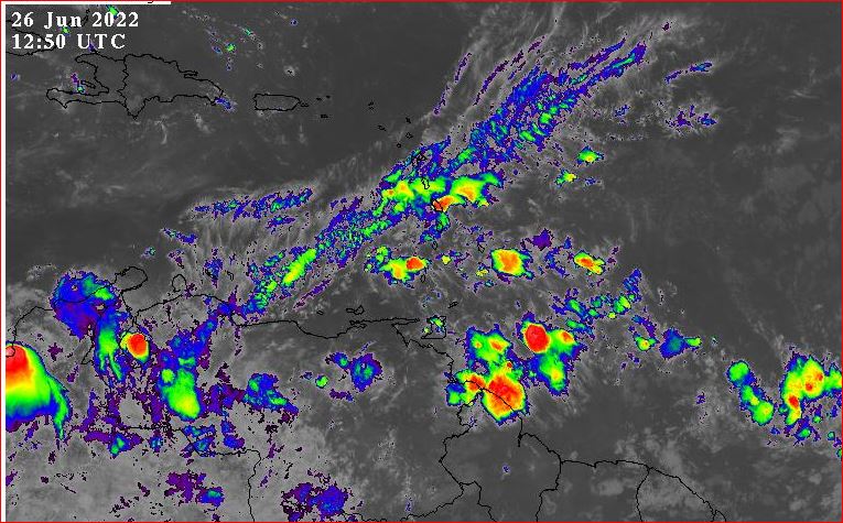
- 2022-06-26th Sun. 09:45am - Update -
|
- By Ian Martin Borde <readkrox51 at gmail.com>
- Date: Sun, 26 Jun 2022 10:03:48 -0400
|
Just Survive!
The welcome 'water' has reached, ... The 'Trio' have a Collective Climate-Change Feature!!!! Which means; Old-fashioned Analysis and the Centre of Circulation mean Nothing. In the SENSE that all 1,500 nautical miles of these Systems are 'Traumatic' and Devastating, ... !!!!
The 1st. Centre of Circulation is about 08 North 58.5 West. [attach: as you can see?] Along with everything else that we are Not prepared for. The 'Worstcase Scenario' is it runs off the Guyana and Venezuela Coast and passes directly over Southwestern Trinidad. However Southwestern Trinidad has a touch of SAL.
The 'most-reliable' but bankrupt site says, Trinidad and Tobago will have maximum Impact between 3:00 - 6:00 pm. today.
Just Survive
GOD! Please Bless! 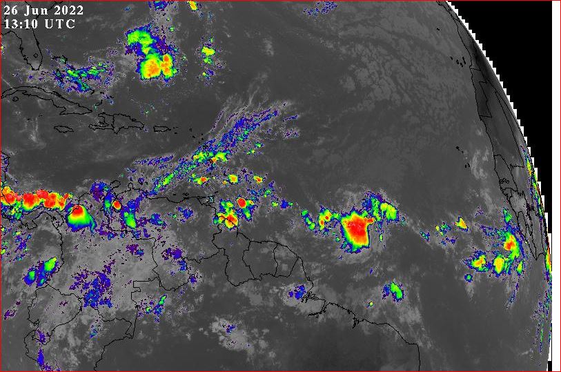
|
|
- 2022-06-25th 6:00pm. Update -
|
- By Ian Martin Borde <readkrox51 at gmail.com>
- Date: Sat, 25 Jun 2022 19:17:17 -0400
|
Please put the saving/making of money as a Lower Priority. During Life and Death Traumatic Episodes the ABC's of Basic Survival. Is the most Important !!!!!!! A - Airways B - Breathing C - Circulation
We are NOT ready But, GOD Bless 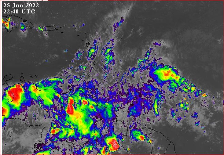
|
|
- Two (02) Blobs in 36 hours -
|
- By Ian Martin Borde <readkrox51 at gmail.com>
- Date: Sat, 25 Jun 2022 07:27:21 -0400
|
My Dearest People of Paradise,
I usually wait for 40 W. to Post advance Notice. But, Due to, Climate Change Characteristics of the Blobs. The soon-to-be absence of SAL. The Presence of formative uncovered Centres of Circulation. I am posting. Mainly to say, when it comes. (Both of Them). It will be minimum Depression. Which in this case means 30 mph. winds.
Last! But Not Least! All forecasters say Trinidad will be Impacted in some way !!!!
God Bless 
|
|
- 2022-06-14th 1:00pm - Update -
|
- By Ian Martin Borde <readkrox51 at gmail.com>
- Date: Tue, 14 Jun 2022 13:21:02 -0400
|
As Isabel accurately said, There are two!!!! This is literally the first one !
My take: This one is less Impactful to the one at 50W. Because, - It's in Windshear. - Barometer and lack of SAL will help the other or next one.
God Bless All Hands on Deck 
|
|
- 1st Significant TW Blob -
|
- By Ian Martin Borde <readkrox51 at gmail.com>
- Date: Mon, 13 Jun 2022 11:33:49 -0400
|
People of The Eastern Caribbean and Paradise,
Mother Nature has taken away our water supply, well almost. But replaced it with an abundance of cheap, natural, liquid Produce. The Harvest is Plentiful. And if we observe the agricultural side to Corpus Christi's Timing. The seeds as well as the soil are Ripe for Planting, ...
That's the good side to Precipitation and Wind. Now for the Hazardous Side?
North West Trinidad has had what I will call, "Non-Stop", four (04) hours of rain at time of posting. My Projections are? Over one (01") inch of rain in 24 hours. Breeze picking up late tomorrow. Not bad for now. Hazardous Weather (be careful of Rivers), for 3 - 4 days. Paths Greatest Intensity, ... , Barbados and St. Lucia.
It's no longer "Be Prepared!". It's, Help the less Fortunate Prepare,
Be Strong
|
|
- "What causes Cyclones?"
|
- By Ian Martin Borde <readkrox51 at gmail.com>
- Date: Wed, 25 May 2022 06:35:18 -0400
|
Westvale Park, Glencoe, Carenage, D'go M'rtn, St. George (West) 2022-05-25th.
"Do we know? What causes a Hurricane?"
It surely isn't. Because of Africa and Primitive Habitats. Apparently it's because, In the Tropical Zone, everyone knows of 'Refreshing NorthEast Trades'. Underknown is, 1) It flows westwards because of 'Rotation'. 2) In the South (Primitive?) it flows Eastwards. (It counteracts the North and flows from Southwest). 3) The South (and North) flows to replace Warm Air.
Therefore, in a Circle.
"Stop the Heat and PRESSURE, and there is no Cyclone".
God Bless 
|
|
- Invisible Troughs, ... !!
|
- By Ian Martin Borde <readkrox51 at gmail.com>
- Date: Mon, 16 May 2022 11:27:14 -0400
|
People of Paradise, I'm Sorry to Say,
I don't know. But, It seems from the past recent occasions. Tropical Waves can now form. Affecting and Including Trinidad. As the Image shows it's more like a Standard Trough or Troughs.
The Barometer Reading for Tropical Eastern Caribbean Waves, runs through South Western Trinidad.
Enjoy it, while it lasts.
GOD Bless 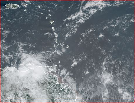
|
|
