|
|
- - - 2020 Hurricane Season - - -
|
- Trinidad and Tobago under Yellow Level weather alert in dry season!
|
- By Christine Westmaas <chrisalis1003 at yahoo.co.uk>
- Date: Sun, 28 Mar 2021 02:27:23 +0000 (UTC)
|
For the first time ever, Trinidad and Tobago has been placed under a Yellow Level Weather Alert in the Dry Season!!! The alert spans the period from 8.00 a.m. on Sunday 28th March. to Tuesday30th March at 2.00 p.m. We have already had some bouts of rain today, Saturday 27th. Rough seas are also expected. |
|
- EVACUATION WARNING ISSUED -
|
- By Ian Martin Borde <readkrox51 at gmail.com>
- Date: Fri, 1 Jan 2021 18:22:37 -0400
|
EVACUATION WARNINGS ON SEVERAL ISLANDS
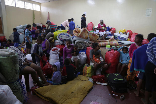
The attached was taken December 30th 2020 Showing a new and enlarged dome quickly forming, . . . !!!!! This is like a cap on an improperly sealed pressure cooker. In the History and Topography of The Soufriere, ... ... , this Dome will be Blasted in The Main Eruption. Ash, INTENSE ASH, Dust, Smoke, Lava, Poisonous Gases will cloud the atmosphere!!!!!!
IT IS NOT A LAVA VOLCANO ! 
|
|
- Merry Christmas -
|
- By Ian Martin Borde <readkrox51 at gmail.com>
- Date: Fri, 25 Dec 2020 07:30:21 -0400
|
|
All the Best for The Season !

|
|
- re: Eastern Caribbean
|
- By Ian Martin Borde <readkrox51 at gmail.com>
- Date: Fri, 11 Dec 2020 08:28:12 -0400
|
Weatherwise; There is a (fairly large) TW approaching in 36 hours. It is greatly disorganised due to SAL over the Lesser Antilles. Wind Shear is moving North-East out of Santo Domingo. The pressure gradient is between the Grenadines and Anguilla. In Faith: Let's see what it brings, ... !
COVID-wise; The Health System is Organizing itself (with International Help included). In the meantime, the see-saw of sickness/mortality and healthcare continues. On a relevant note. The Education System is getting a Christmas Break.
I Hope and I Pray, G O D Bless 
|
|
- Northerly Tropical Wave
|
- By Ian Martin Borde <readkrox51 at gmail.com>
- Date: Wed, 25 Nov 2020 14:34:30 -0400
|
2020-11-25th. Wed. 2:20pm.
Weatherwise: There is a TW North enough to affect T&T. In four hours time and lasting 18 - 24 hours. (That is localized heavy rain, not, mountaintop precipitation we currently get.) No breeze, no waves, just visibility and water.
Otherwise: Either WISELY or AS YOU SUSPECT ! No Congregating Allowed for Christmas. (Nobody talks about Carnival next year, God Permit?) Second Stimulus/Relief Cheques en train. For a selected segment of population. Migrants / Refugees without Portal, still coming. My Take: Air of Permanence re: Refugees???
We'll See. I know Nothing. 
|
|
- The Latest ! (Where I am concerned). -
|
- By Ian Martin Borde <readkrox51 at gmail.com>
- Date: Tue, 17 Nov 2020 01:52:51 -0400
|
|
|
|
- (sob, ...) Truly T R A G I C !!!!! (SOB, SOB, SOB, .... )
|
- By Ian Martin Borde <readkrox51 at gmail.com>
- Date: Mon, 16 Nov 2020 23:17:59 -0400
|
|

|
|
- Circulation Started -
|
- By Ian Martin Borde <readkrox51 at gmail.com>
- Date: Thu, 12 Nov 2020 18:45:18 -0400
|
2020-11-12th Thu. 6:30pm.
Circulation has started.
Winds (only in the North) are 15 - 20 mph. Precipitation less than 2" inches.
(I feel sick of this).
Prepare, ... 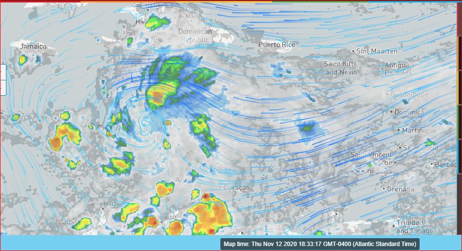
|
|
- Wishing for a New Year ?
|
- By Ian Martin Borde <readkrox51 at gmail.com>
- Date: Wed, 11 Nov 2020 09:44:09 -0400
|
The image speaks for itself, ...
Winds still less than 20mph.
Even though there is NO Circulation. The axis, (perpendicular with Hispaniola), is shaping out a Center. - At the Moment - 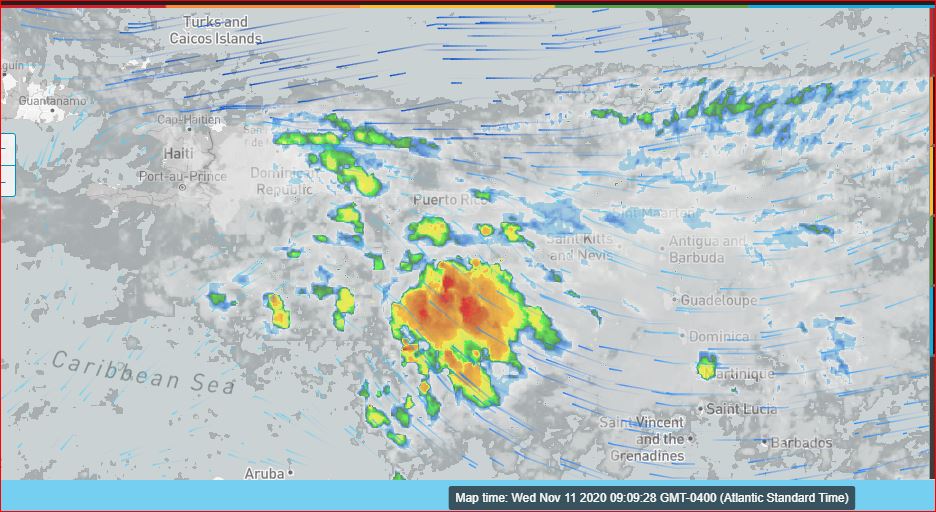
|
|
- Avec La Remorse -
|
- By Ian Martin Borde <readkrox51 at gmail.com>
- Date: Wed, 11 Nov 2020 09:35:59 -0400
|
Chers Martinique,
Veuillez de Accepter, Notres sympathies avec la morte dans l'île.
Il faut de penser qu'elle est la première en 'The Lesser Antilles'?
On prie que cette etait La Derniere.
Dieu vous benisse |
|
- Dignity - Integrity - Respect -
|
- By Ian Martin Borde <readkrox51 at gmail.com>
- Date: Wed, 11 Nov 2020 09:24:30 -0400
|
To: The Fallen 'We Shall Not Forget' 
|
|
- Wise Men Know Nothing !
|
- By Ian Martin Borde <readkrox51 at gmail.com>
- Date: Thu, 5 Nov 2020 02:29:32 -0400
|
With a Heavy Heart ! I hesitate to analyse and say, "We have seen the last of Cape Verde Storms!"
Before, the cessation was due to windshear. With a few troughs getting through?
Now! A typical, normal wave crashed into the Guyanas. The ITCZ (Meridian/South Summer) is low enough NOW ! Thank GOD. 


|
|
- Start Preparing to Assist -
|
- By Ian Martin Borde <readkrox51 at gmail.com>
- Date: Wed, 4 Nov 2020 00:56:51 -0400
|
Wednesday 04th. November 2020 T'dad & T'bgo, WI. 12:50 am.
S T A N D I N G R E A D Y 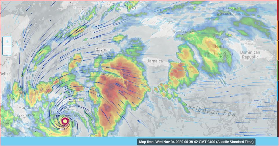
|
|
- ... , with Jamaica in Mind, ...
|
- By Ian Martin Borde <readkrox51 at gmail.com>
- Date: Sat, 31 Oct 2020 10:39:55 -0400
|
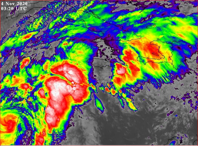
Hearty Weekend Greetings, People of Paradise, 2020-10-31st. Sat. 10 : 15 am.
There are a lot of Pluses, Weatherwise and Otherwise! I can only list a few in My Take?
Weatherwise: - There is no Circulation as Yet ! - I don't see Circulation until it exits Cuba. While Jamaica, and Haiti are definitely in the picture. - I see it passing in between and over Eastern Cuba. On Jamaica and Haiti Impact as it stands now. - I only see over 2" ins. in isolated/localized spots. REMEMBERING: It has the longest tail, I have ever seen!!!!!!
Otherwise: It's All - Fruits & Vegetables - (With lowering Prices, ...) Definitely, on the bad side: Each Day is a new Nightmare on which Businesses closed its doors. I forgot: Travel is Gaining Momentum and the Positive Patients and Fatalities are Steadying off. In Marginal Analysis, this is a decrease. However there is a lot of disappointment in the younger generation. Simply Because, nobody has acknowledged how traumatised they are!!!!
GOD, Please Bless 
|
|
- Watch out for - A Last Hurrah -
|
- By Ian Martin Borde <readkrox51 at gmail.com>
- Date: Sat, 17 Oct 2020 17:29:05 -0400
|
I am going to follow up on this post. So please accept my Brevity.
There are two embryonic systems east of us. One laterally in line with Barbados. Expected in 12 - 36 hours. Waves: averaging 8' feet. Wind: 12 - 15 mph. Water 2" inches. (localized areas could be more).
The other is four (04) days away. (My 'bottom-line' suspicion is that it has potential!) Even as a 'Trough'. One of a few reasons, there is no SAL (Dry Air).
Cape Verde Storms don't watch the Calendar.
God Bless

|
|
- Standing By !!! -
|
- By Ian Martin Borde <readkrox51 at gmail.com>
- Date: Tue, 6 Oct 2020 04:09:57 -0400
|
- Call for Help -
- Remain Calm -
- Don't Make a BAD SITUATION worse -
Standing By
GOD is Blessing 


|
|
- Centre of Circulation (CoC) forming (12 mph.)-
|
- By Ian Martin Borde <readkrox51 at gmail.com>
- Date: Mon, 5 Oct 2020 02:51:58 -0400
|
This Update Post: Is Disjointed with Bare Facts coming at You.
I apologize, ...
A Centre of Circulation ('Eye') is forming in 'Delta' with sustained winds of 12 mph. Winds are 18 mph. throughout Jamaica. The NorthWest EyeWall has relatively no moisture Protection. Precipitation is rapidly growing. With Precipitation close to two inches, not quite as yet ! 'Delta's' Centre is perpendicularly South and West of Jamaica but only Marginally. (Rain has eased up in East Puerto Rico and Eastwards.)
'Epsilon' has a trough axis, slightly north of Antigua and Barbuda laterally-speaking. Not a threat to anything.
'Gamma' has sustained winds of over 40 mph. 75 - 90 miles wide.
Trinidad had an Earthquake, 4.7 - 5.2 , particular to Trinidad. Specifically North West Trinidad.
It's still early, But, Standing by 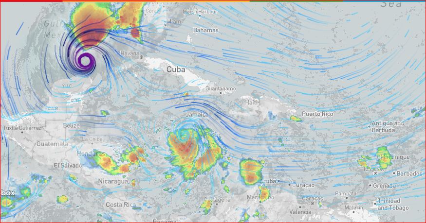
|
|
- Remembered the Third Thing -
|
- By Ian Martin Borde <readkrox51 at gmail.com>
- Date: Sun, 4 Oct 2020 13:52:05 -0400
|
Glencoe, Carenage, T&T, WI. 2020-10-04th. Sun. 1:30 pm.
People of Paradise, specially Jamaica and Haiti,
Things are getting interesting, . . . !! Rather, Don't let your guard and survival skills down. Because things continue to be interesting !! And, Complacency Kills !!!
- Les Cayes, Haiti - Isabel Segunda y Culebra, Puerto Rico - Had more than 0.80 inches of rain. - British Virgin Islands, Dominica, Martinique, Tobago and Trinidad - Similar, but not as much. Winds North of Jamaica are 21 mph.
That tells us what to expect in 36 hours.
As evidenced by the DISTANT Drum Party in the skies close to and above North-Western Trinidad. (No Lightning!)
"I wonder how 'Benji' and the 'small brown dog' are doing in all this up and down?"
Complacency Kills
God Bless and You do The Rest 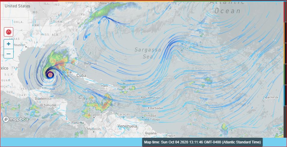
|
|
- Have to Post (but Nothing Urgent, okay?) -
|
- By Ian Martin Borde <readkrox51 at gmail.com>
- Date: Sat, 3 Oct 2020 14:21:39 -0400
|
(Trying to eat an already-cooked lunch a hour and a half now!!!)
On the bright side, It's nice to feel needed again.
At exactly midday, the one to watch (20%), is at approx. 12 North and 41 West. Yes, it has an identifiable Centre. In lateral terms that's between Grenada and North Trinidad. Most authoritative forecasters see it going North. I am not going to even speculate, far less add nonsense.
The one that is giving ALL of US, a REPRIEVE. (Delta?) Is attracting precipitation over Tobago moreso, and Trinidad. The slight wind and water is due to its (Delta's) interaction with ?Epsilon??? to the East of us and inauspiciously over Tobago.
There is a third thing. But, I can't remember now. And really need to tie off loose ends. (See about what is Mine and Myself.)
GOD Bless 
|
|
- No-Surprise, Surprise ! -
|
- By Ian Martin Borde <readkrox51 at gmail.com>
- Date: Wed, 30 Sep 2020 23:31:36 -0400
|
Briefly, but GOOD NEWS:
There are three weather systems between 10 - 20 N. Latitude in the Atlantic Region. The system affecting St. Lucia and that will be with (all of) us tonight and tomorrow bears the most Hazardous conditions at the present moment ! But with actual Scientific Data, ... , it's as follows:
Winds: less than 25 mph. Waves: (can't afford precise data but) less than 10' ft. Water: slightly, slightly, slightly less than two (02") inches.
Not that bad, won't you say ?
St. Lucia already has close to one inch.
Let me see if I can say something nice, like about flora and fauna. Besides the fact I can't bear witness to any fatalities for the first half of the season in the Eastern Caribbean?
Avocadoes, aka 'zabocas' and 'pears', sweet ones, watery ones, filling ones, along with passion fruit and limes are everywhere.
COVIDwise: There is (practically speaking) food, local nutritious food. Local includes nearby islands. At every street corner. People are cooking and eating at HOME, x2 times a day.
Transportation expenses are not a problem with domestic disposable income. But FOOD, medical supplies and toiletries and frontline ?labor? are throwing people out of pocket. You have to shop around and be innovative if not CHEAP!!! So much so, the jolt to my disposable income routine was so abruptly confusing. I got disconnected from the internet in the third month with two months arrears.
Well at least, the crime and delinquency is so in check. That Captain Marvel, The new Police Commissioner, went on Leave after doing a stupefying, long haul over two years. (Personally, I would have given everybody working in the medical field, including the top, a National Award)!!!!!!
God is Blessing us in ways and Timing we can't grasp, ...

|
|
- C o n g r a t u l a t i o n s ! -
|
- By Ian Martin Borde <readkrox51 at gmail.com>
- Date: Thu, 24 Sep 2020 12:40:37 -0400
|
Congratulations, Dave and Melody, . . . , Forever !
"It couldn't have happened to a Finer Gentleman!"
+++
God Bless
|
|
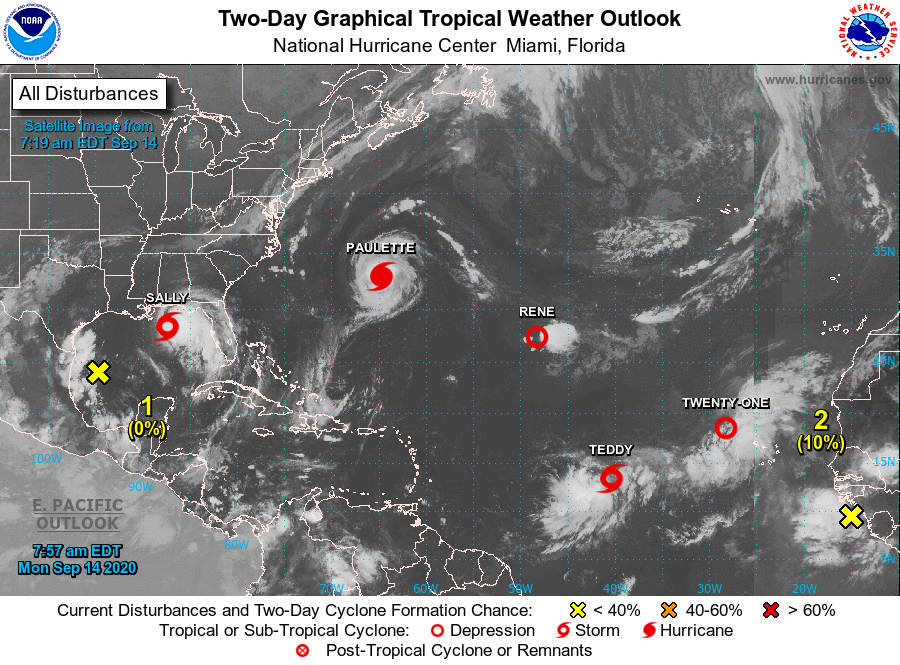
- Two Others ? -
|
- By Ian Martin Borde <readkrox51 at gmail.com>
- Date: Mon, 14 Sep 2020 11:46:59 -0400
|
|


|
|
- Bermuda Impact -
|
- By Ian Martin Borde <readkrox51 at gmail.com>
- Date: Mon, 14 Sep 2020 09:20:53 -0400
|
Winds are around 72 - 87 mph. (and Higher)
I have a special LOVE for Bermuda and The Bahamas. 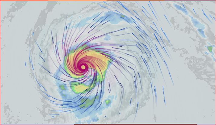
|
|
- FeederBand -
|
- By Ian Martin Borde <readkrox51 at gmail.com>
- Date: Wed, 9 Sep 2020 08:09:58 -0400
|
People of Paradise,
I am not taking time from something or someone else, to post that Trinidad will have rain today.
The 'Feeder Band' of 'Paulette' extends to Trinidad.
God Bless |
|
- Hark! What goes there? Friendly or Not? -
|
- By Ian Martin Borde <readkrox51 at gmail.com>
- Date: Sun, 6 Sep 2020 07:28:25 -0400
|
Glencoe, D'go M'rtn, 2020-09-06th. Sun.
"Everybody is Doing Well so far". This, The Peak of The Season, . . . ! Don't Be Superstitious ! But, at the same time. "Our Collective Hopes and Perspiration is Working".
Weatherwise: The Blob with Circulation that is stationary for one week !!! Has now Digested Everything around it ! Seems to have inched south !
Pray, Plan, Prepare, ProCure and Don't Panic !!! All, all People and Property !!! 
|
|
- Ill-Fated 40 W. -
|
- By Ian Martin Borde <readkrox51 at gmail.com>
- Date: Wed, 2 Sep 2020 09:38:31 -0400
|
My Dear People of Paradise,
Trinidad and Tobago had yesterday and today, the two (02) 'Most Glorious Sunrises' and Sunshine, Wafting Breezes and Embracing Humidity during sunlight hours.
Why worry about COVID-19 and what else have you? Like being unable to go to the Beach and Rivers. When one can open their windows and see and feel and smell 'Goodness' !
Weatherwise:
At 40 W. Longitude is the first (1st.) of three maybe four Tropical Waves with Low Pressure.
Do Your Best while God Bless 
|
|
- Circulation by Tomorrow Highly Improbable -
|
- By Ian Martin Borde <readkrox51 at gmail.com>
- Date: Sat, 29 Aug 2020 05:50:11 -0400
|
People of Pardise, God is Great, To Him Be The Glory !
I should complete my 'catchingup' today, so I have time to post. Once again, "God is Great!"
It is highly, highly improbable that the TW tomorrow night can develop Circulation.
I see St. Lucia in the picture. And if 'Laura' passed thru Haiti, then they should sleep with one eye open. I don't want to cry again. But there are a STREAM behind the TW tomorrow.
Let it be said, "I know Nothing". It's just a precautionary 'take'.
God continue to Bless us, Please
|
|
- Two TW's to Watch !!! -
|
- By Ian Martin Borde <readkrox51 at gmail.com>
- Date: Thu, 27 Aug 2020 13:08:18 -0400
|
Quickly:
I am very BUSY, (Personal, Family and Friends, Responsibilities, other) So even though we have SYSTEMS from ill-fated 40W. go back. I am resting off online on stormcarib.
Believe me, If you help one (01) person, ... , you have helped alot !!!!!!!!!! I am Busy Helping, . . . !
Just don't ask me for actual money.
God Bless |
|
- Hispaniola in Trouble -
|
- By Ian Martin Borde <readkrox51 at gmail.com>
- Date: Sun, 23 Aug 2020 05:25:46 -0400
|
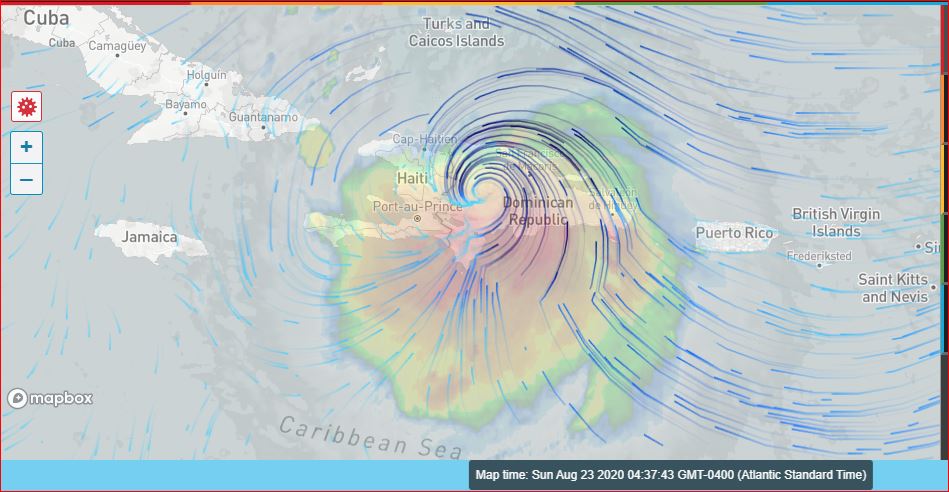
From southeast Santo Domingo to Cap-Haitien I see over three inches of Rainfall, . . . !!!!!!
Hoping Port-au-Prince is spared the winds.
'Laura' is in the middle of Hispaniola.
See attached:
(and do something about it, ... ?) 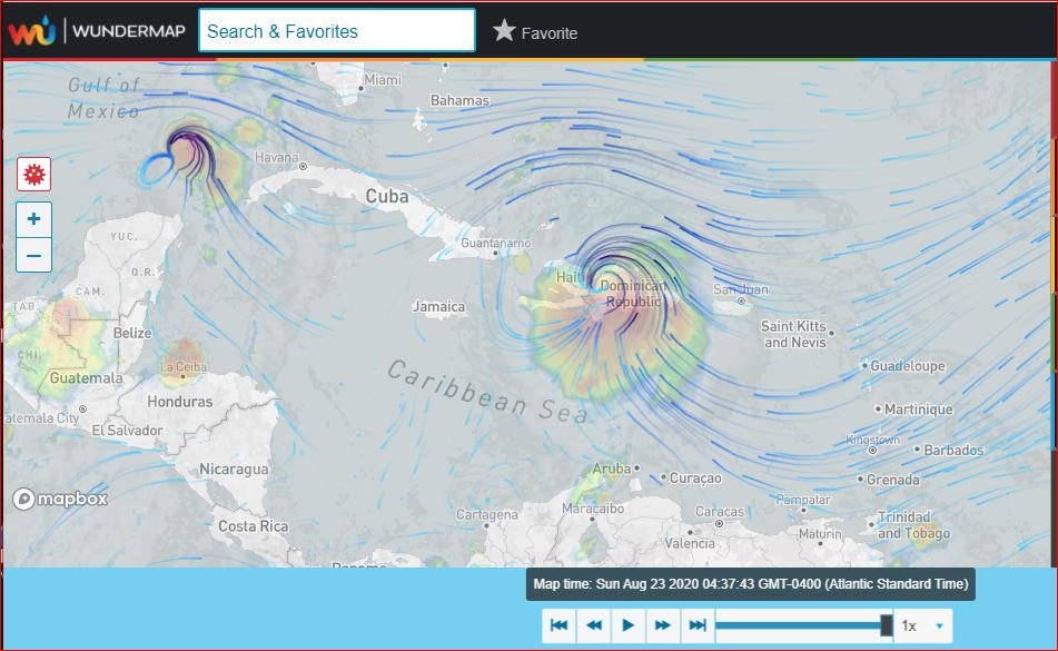
|
|
- Partial - All Clear -
|
- By Ian Martin Borde <readkrox51 at gmail.com>
- Date: Sat, 22 Aug 2020 20:44:30 -0400
|
Left to me, I would give. St. Marteen, St. Kitts Nevis Antigua Barbuda Montserrat Guadeloupe Dominica, a PARTIAL All Clear.
Only for the reason of MITIGATION !!
GOD Bless 
|
|
- Definitive Storm - Possible Category 1 -
|
- By Ian Martin Borde <readkrox51 at gmail.com>
- Date: Sat, 22 Aug 2020 09:33:21 -0400
|
First,
Montserrat, St. Kitts and Nevis had it worse than Antigua and Barbuda. [Close to two inches rain and stronger winds over 20mph.] "As soon as Communication allows it. Let us know."
Secondly,
The Center started its northward trek on the southeast coast of Puerto Rico at 08:45am. My take is, "It will transition as a Cat 1 over the Entire Puerto Rico !!!!" ["Hoping and Praying, ... , Laura leaves Haiti alone"!!!! and that a Frontal System appears out of nowhere and pushes it slap - dab in the middle of the Atlantic.]
I know Jamaica is on this website and works well with T&T in situations like the aftermath.
Haiti: Trinidad et Jamaique se teindent pret.
DR y P'Rico: Si se tienen communicaciones? Estamos listos a servir.
I had my day(s) with this. And I am fighting to keep my composure. Elections started or Finished and even detractors and profit-seekers are beginning to need me again. Thus allowing me little by little to speak. "I wish a certain someone would walk like Forrest Gump. But in their case, DON'T COME BACK!"
Once again; Leewards let us know? 
|
|
- Direct Touchdown on Antigua & Barbuda -
|
- By Ian Martin Borde <readkrox51 at gmail.com>
- Date: Fri, 21 Aug 2020 15:16:21 -0400
|
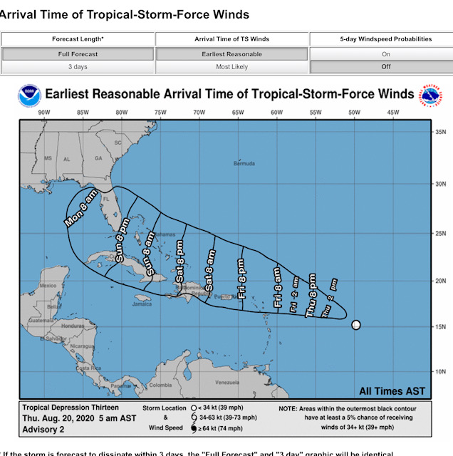
As I write (3:00pm.) Antigua and Barbuda is getting a Direct Hit.
We are ALL on Standby !
It has no tail. But, All the PRECIPITATION is to the South!!!
IT'S NOT OVER !!!!!
Standing By, . . . !!! |
|
- S L E E P - Pray - Do Yoga -
|
- By Ian Martin Borde <readkrox51 at gmail.com>
- Date: Thu, 20 Aug 2020 22:16:12 -0400
|
2020-08-20th Thu. 9:45 pm.
Try to get some REST / SLEEP.
Laura and Marco (The Center) have not reached as Yet !!!!!! Being Aware that HELP is All Around YOU. Is The Most Important Thing !!!!!! But, Once you are Aware of The Deluge of Help. Get Some REST ! Go to S L E E P, . . . . Because the 2nd. Most Important thing is, ... DON'T MAKE A BAD SITUATION WORSE, ... !!!!!!!
Now, for the Bad News:
I don't disagree, I agree. Just adding? - Dominica is in the picture. - There is a slim chance it can pass north of Guadeloupe. - Arrival time is whole day tomorrow from 04:30am. (Friday). - Climate Change is Synonymous with Rapid Intensification ! - Given the Addendum I present, work your way up!
To a Brighter Tomorrow !!!!!!
Standing By 
|
|
- T&T 50% chance of POTENT TW Direct Hit Tomorrow
|
- By Ian Martin Borde <readkrox51 at gmail.com>
- Date: Sat, 15 Aug 2020 17:17:19 -0400
|
May The Creator be Praised, ... Now you see what Silence (anti-Panic) and Faith; Humanity's Efforts for Truth. Is Able to get us through a Terrible Time / 2020. Two Named Storms! and, No Contact with Land as yet?
COVID-wise:
The PNM won 22 to 19 (UNC) seats. The Popular (Aggregate) Votes. Entire Tobago, Port of Spain and SanFernando. We are going into almost 100% Lockdown from Monday. and, When Parliament resumes, Facemasks Mandatory.
GOD is Blessing us now 
|
|
- 50/50 Blob in 24 Hours -
|
- By Ian Martin Borde <readkrox51 at gmail.com>
- Date: Wed, 5 Aug 2020 20:26:45 -0400
|
Just Quickly, People of Paradise,
There is a well-defined Tropical Wave without any type of circulation. That has a 'Strong' Chance of dropping more than one inch of rain. It will reach in 24 hrs. That is Thursday Night/Friday morning!!
The problem is , ... , The SAL will also clear up in 24 hours.
God Bless 


|
|
- Heartfelt SUPPORT to The BAHAMAS
|
- By Ian Martin Borde <readkrox51 at gmail.com>
- Date: Fri, 31 Jul 2020 12:05:12 -0400
|
I don't know what to say. So gonna be very, very brief but Definitely NEGATIVE.
One of the imps from 'Isaias' tore down this tree Yesterday 2020-07-30th on Brian Lara Promenade which is in the City Centre of Port of Spain.
Apparently this same short-lived (10mins.) Storm had sideways rain gushing under my front door.
"Let us know how we can Help".
But, (It's getting close to time when I can talk, ...) Now is Election Time.
Let us know how we can Help??? 
|
|
- Hope + Pray -
|
- By Ian Martin Borde <readkrox51 at gmail.com>
- Date: Wed, 29 Jul 2020 04:57:58 -0400
|
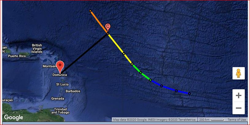
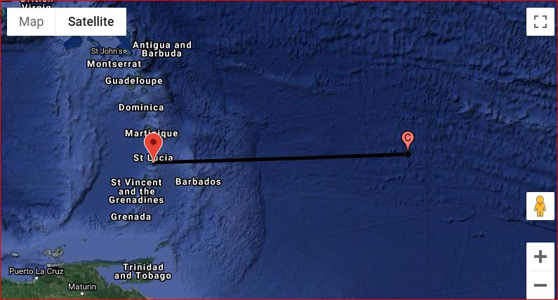
The tip of the Centre has touched the SouthEast Coast of Dominica.
Dominica had over two and a half inches of rain. Just Imagine ! Barbados bordered on two inches of rain. Just Imagine !
Hope and Pray, ... ! 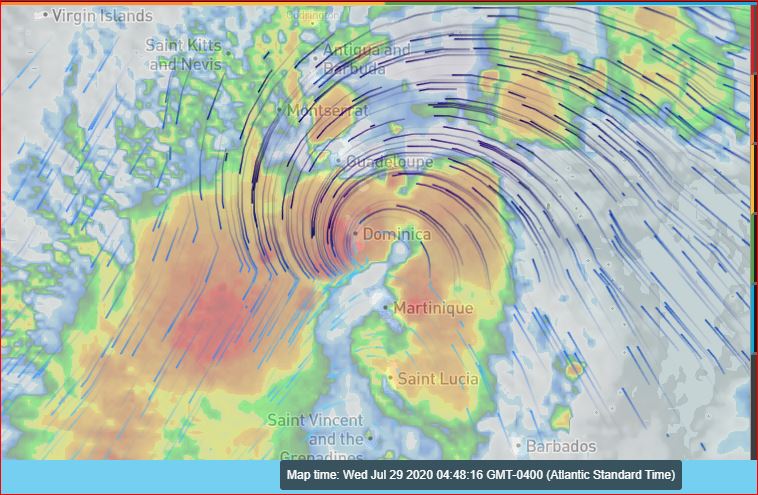
|
|
- Left out the most important one -
|
- By Ian Martin Borde <readkrox51 at gmail.com>
- Date: Wed, 29 Jul 2020 00:32:24 -0400
|
|
|
|
- SAD Not To Say! Very SAD ! -
|
- By Ian Martin Borde <readkrox51 at gmail.com>
- Date: Wed, 29 Jul 2020 00:22:11 -0400
|
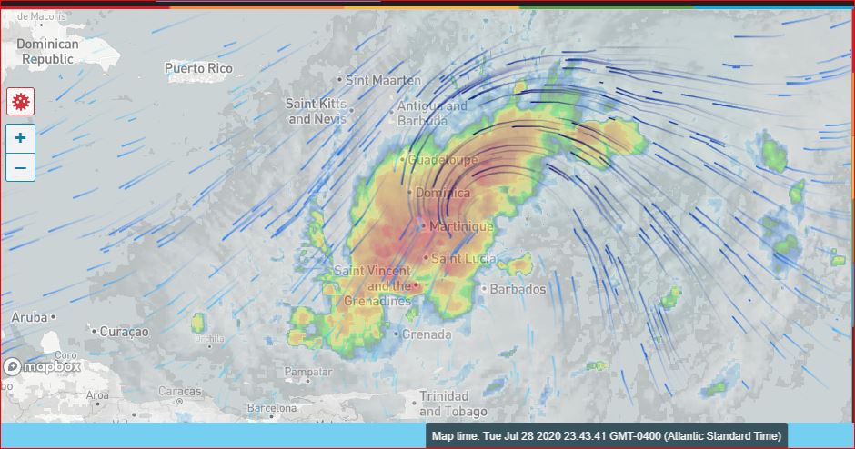
Tears are in my eyes as I write. I think of Puerto Rico. I think of Puerto Rico in three days time. I think of Dominica and The Dominican Republic. I think of St. Maarten and Barbuda. I think of School Children.
Even I, Have been Silenced !
[Quote: Ian M. Borde] "It is sad! When someone can't say. What needs to be said. Because, even little children speak and listen to the truth!"
Besides attaching images, ... , which I hope came out good.
That's all I can say for now.

|
|
- Seriously Hazardous Rain-Event !
|
- By Ian Martin Borde <readkrox51 at gmail.com>
- Date: Tue, 28 Jul 2020 03:51:18 -0400
|
Trinidad has gotten COPIOUS RAIN tonight from the Imps. This is gonna be a Rain-Event to go down in The Books. Prepare !!!! It has no Centre. The Definition of a Depression should change, ... ??? (Rain, not Wind is the Killer Factor in Climate Change!!!!) Anything above 2" inches, ....
In spite of a 2020 that has given me No Relief whatsoever, ...
GOD Bless 
|
|
- 40 West - ?('Isaias')? -
|
- By Ian Martin Borde <readkrox51 at gmail.com>
- Date: Mon, 27 Jul 2020 05:30:19 -0400
|
Good Night, Good Day, People of Paradise,
The ill-fated 40W. And, Still not a named Depression !!? Why ? "I ask?"
I am not going to have 'a take' or a 'as I see it'. Except, I will be Negative, ... ... , and say, "I don't see Dominica getting a Direct Hit!"
Weatherwise: We had a Tropical Wave yesterday with Thunder and Lightning. It lasted less than 10 minutes. On a bright and beautiful Sunday.
'Isaias', the Depression entered the area of windshear, its top and centre is digesting dust so much so. That no moisture is protecting the Centre. It's spinning slower than Gonzalo. Broad storms tend to dissipate easier but REMEMBER: Storms and Water temps. don't disappear. The graphical representation disappears.
"Don't you think God is trying to tell us who is in charge?"
GOD Bless 

|
|
- Update at 2:20pm.
|
- By Ian Martin Borde <readkrox51 at gmail.com>
- Date: Sat, 25 Jul 2020 14:29:44 -0400
|
|
The Centre has broken up!!!
|
|
- Update at 1:00pm. -
|
- By Ian Martin Borde <readkrox51 at gmail.com>
- Date: Sat, 25 Jul 2020 13:19:54 -0400
|
The Centre entered 'Manzan' at 1:00pm.
The Grenadines, Tobago and Grenada can begin Recovery.
Tropical Storm Force Winds have only NOW entered Trinidad !!! (Sangre Grande in Particular, . . . !)
Standing By, (but resting for Lunch, one hour and a half, ie. 2:30pm.) 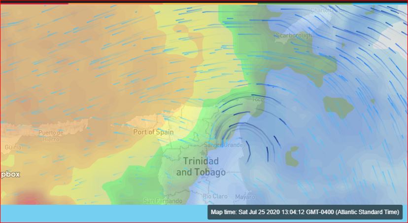
|
|
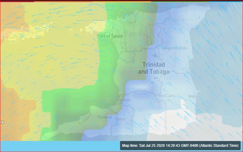
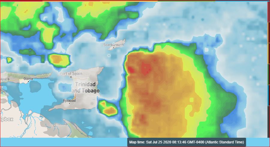
- Update at 11:05am. -
|
- By Ian Martin Borde <readkrox51 at gmail.com>
- Date: Sat, 25 Jul 2020 11:12:02 -0400
|
Caution:
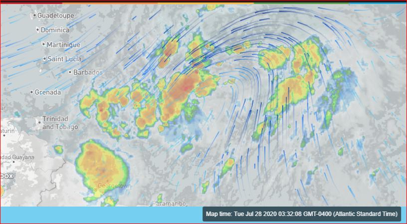
The Centre is not where you think it is? The heaviest precipitation passed thru the channel! Thank God!
At 11:00am. The Centre is Off Mayaro/Toco.
The caution can't be Lifted !!!!! 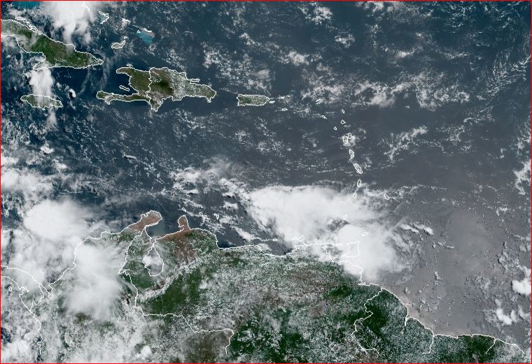

|
|
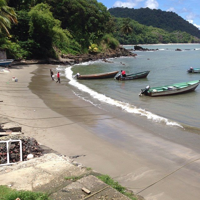
- Landfall for Gonzalo in Toco Trinidad
|
- By Adesh Nanan <adeshcnanan at gmail.com>
- Date: Sat, 25 Jul 2020 09:00:18 -0400
|
Dear Gert, At this time in Palmiste San Fernando Trinidad,sporadic wind gusts with squall of showers and heavy overcast. No thunder temp falling. Reports of heavy rainfall in Tobago and all over Trinidad. This disorganised storm is packing a punch
Dr Adesh Nanan |
|
- Listen to The Authorities -
|
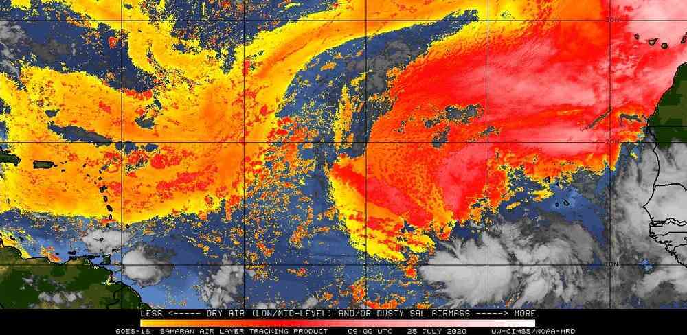
- By Ian Martin Borde <readkrox51 at gmail.com>
- Date: Sat, 25 Jul 2020 08:57:11 -0400
|
People from the Grenadines (and St. Vincent), Grenada, Tobago and Trinidad, ... Good Morning Blessings !
As Hogan said, we are NOT The Authorities !!!!! We know Nothing and are just QUOTING FACTS, . . . !!!!!
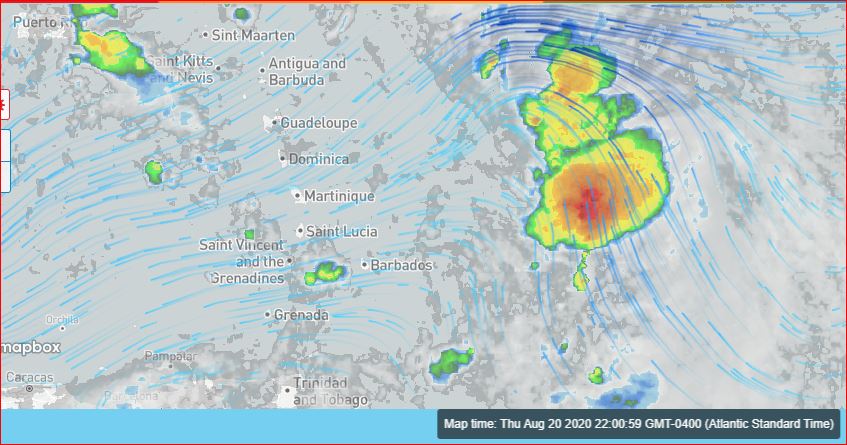
Tobago at 08:30am. started to be Impacted by Storm Winds. In the vicinity of Goldsboro Bay.
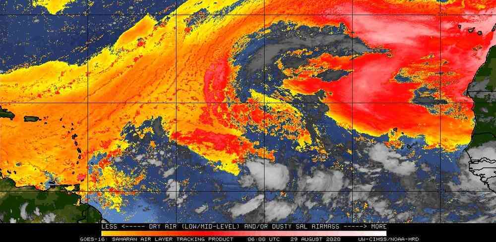
Carriacou has been affected the most (Precipitation-Wise) the most so far. St. Lucia is covered in Dry Air. As per the 05:00am SAL Graphic.
If you look at the jetstream image. The Centre (of a Depression/Storm) will make landfall Between Goldsboro Bay in Tobago and Matura Bay in Trinidad.
In The Name of Jesus, more and more I am tempted to say, the centre will pass through the channel between Trinidad and Tobago.
(Please see my previous post for timing?)
GOD BLESS 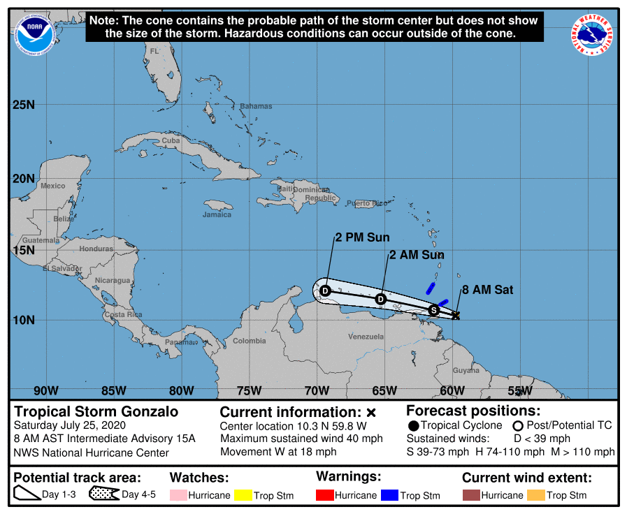
|
|
- Here We Go - Stay Indoors -
|
- By Ian Martin Borde <readkrox51 at gmail.com>
- Date: Sat, 25 Jul 2020 05:27:09 -0400
|
STAY INDOORS !
There is the temptation to say it will pass thru the channel between Tobago and Trinidad. Instead, I am trained to paint the worst case scenario and work my way up. (It saves lifes!) I see: - Landfall happening from NOW !!!!! - The Centre landfalling in Toco, just south of Toco, including Toco, then Sangre Grande, Arima/St. Augustine and Piarco. Ie. The Centre ! - I see it Dispersing or Intensifying. But, NOT staying the same. - I see Destructive Impact from 09:30am - 7:30pm. - I see a Plus, there is no tail to speak of.
STAY INDOORS
DON'T DRIVE THRU WATER
LISTEN TO THE AUTHORITIES
ASK FOR HELP
STAY INDOORS 
|
|
- Feeder Band for Trinidad
|
- By Adesh Nanan <adeshcnanan at gmail.com>
- Date: Sat, 25 Jul 2020 02:43:30 -0400
|
Dear Gert I just looked at the Barbados met service graphic for pathway of the storm and it appears that a feeder band will affect Trinidad while Tobago will experience more direct confrontation
Dr Adesh Nanan |
|
- Double whammy!...Possible Community spread of Covid19...and a possible hit by Tropical Storm for Trinidad
|
- By Adesh Nanan <adeshcnanan at gmail.com>
- Date: Sat, 25 Jul 2020 01:15:14 -0400
|
Dear Gert Yesterday there was a case of possible local transmission of the COVID...and now Gonzalo appears to be cutting a path to Trinidad. I CONTINUE TO PRAY FOR THE SAFETY OF THE PEOPLE! Ephesians Ch 2
Dr Adesh Nanan
|
|
- THANK GOD Gonzalo...is a small storm...25 miles wide!
|
- By Adesh Nanan <adeshcnanan at gmail.com>
- Date: Sat, 25 Jul 2020 01:02:56 -0400
|
Dear Gert The humidity is high and temp high in Palmiste in San Fernando Trinidad...classical signs of an approaching storm. By my calculations the storm is 6 hours away. The only advantage here is that it will be daylight when the impact will be felt I continue to pray for the people of this beautiful twin island Republic that is dealing now with possible community spread of Vivid 19.
Dr Adesh Nanan |
|
- Tropical Storm Gonzalo is very unpredictable
|
- By Adesh Nanan <adeshcnanan at gmail.com>
- Date: Sat, 25 Jul 2020 00:16:27 -0400
|
Dear Gert, At this time in Palmiste ,San Fernando in Trinidad thunder is rolling in the distance. No rain as yet but instability in the atmosphere. Eerie calm now! We wait and watch mother nature.
Dr Adesh Nanan
|
|
- Tonight we get a Closer Picture - Monitor -
|
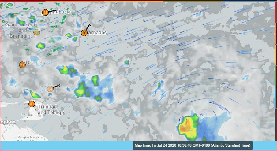
- By Ian Martin Borde <readkrox51 at gmail.com>
- Date: Fri, 24 Jul 2020 19:55:21 -0400
|
Still trying not to say much.
Listen to NHC and the Authorities, . . . .
Reason for Posting? (I'll be up most of the Night). No Matter what happens, . . . ! ! ! The Windsweep will be from Grenadines to Trinidad. Yes! Trinidad (North and South) is DEFINITELY INCLUDED !
There are two Progresssive Attachments and a SAL at 5:00pm. (inversely).
Standing By, (till Sunday Morning), . . . 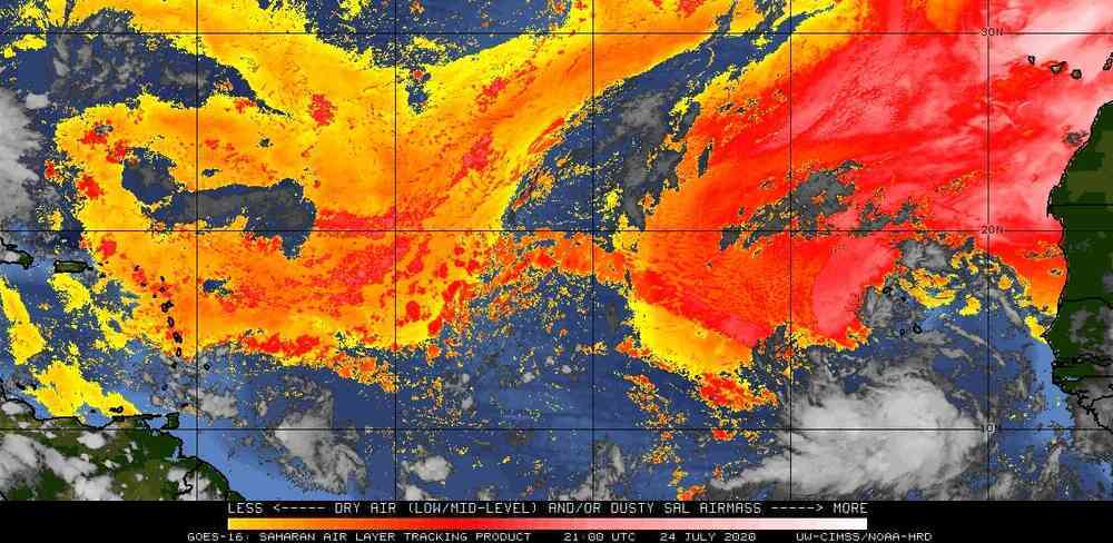

|
|
- Gonzalo's Arrival
|
- By Stephen Abouhamad <stephen_abouhamad at hotmail.com>
- Date: Fri, 24 Jul 2020 12:44:04 +0000
|
|
22nd Jul, 2020
Good Morning folks.
It has been a little while i have posted on this site. Gonzalo is a little trouble maker for Tobago. Hope everyone is safe.
Regards,
Michael Abouhamad
|
|
|
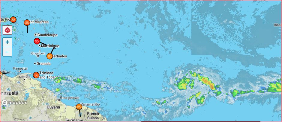
- Approaching Tropical Storm Gonzalo
|
- By Adesh Nanan <adeshcnanan at gmail.com>
- Date: Fri, 24 Jul 2020 07:51:31 -0400
|
Dear Gert This scenario is almost identical to 3 years ago when an approaching Tropical Storm jagged NW at the last minute and spared Trinidad and Tobago. I pray for another miracle for Tobago despite the latest models. Jesus Christ is in charge!
Dr Adesh Nanan |
|
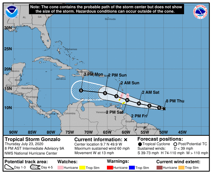
- 50West - Deadline for Preparedness - 50West
|
- By Ian Martin Borde <readkrox51 at gmail.com>
- Date: Thu, 23 Jul 2020 20:50:25 -0400
|
People of Paradise,
'Gonzalo' is at 50 West!
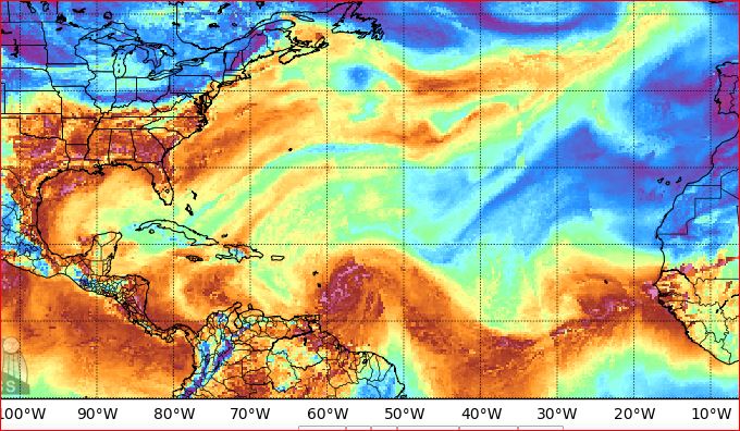
There are two attachments; 1) 2020-07-23rd 8:00pm NHC Advisory, ... !!!!! 2) Sahara Dust (SAL) at 2020-07-23rd 5:00pm.
I am in Full Agreement with this Latest Advisory! Except, I see it Exiting the Eastern Caribbean 04hrs. later. (04:00 - 07:30am.) (Even then, it has a tail by then!)
I don't Think, it is Highlighted Enough that, a) It's going to Intensify. b) It is NOT a straight line or Graphic. c) TOBAGO (as well as parts of Trinidad) are in the picture.
If you are a Critic, I say this because of, i) The SAL jet stream. ii) The Historical Nature of Climate Change.
The Point however is, "If you wait anytime after 50W. to PREPARE. YOU ARE TEMPTING THE DEVIL!!!!!" If you are not a Critic and worried about Financial Opportunities, ... ? Factors like, You are not covered by Insurance. First responders will find it difficult to help you . Begin to introduce themselves, ...
God Bless, because I can go on and on , . . . . 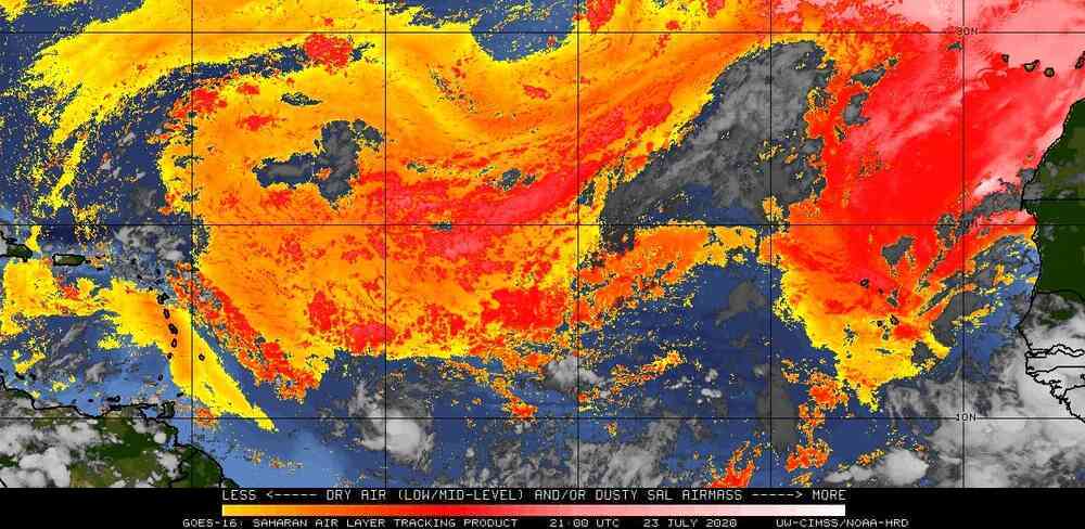
|
|
- Truly Thankful for stormcarib.com -
|
- By Ian Martin Borde <readkrox51 at gmail.com>
- Date: Tue, 21 Jul 2020 10:40:44 -0400
|
I am NOT going to say much.
Just leave these two images at the ill-fated 40W.
Don't Panic. Ask for Help (in Your Preparations), . . . & Prepare You Must !
Be Prepared
GOD Bless 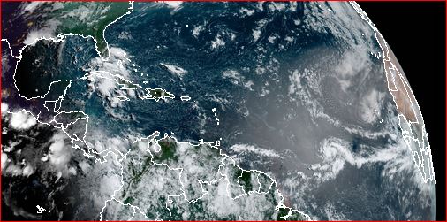
|
|
- The K E Y is "Prepare" -
|
- By Ian Martin Borde <readkrox51 at gmail.com>
- Date: Mon, 20 Jul 2020 08:06:14 -0400
|
You see what I mean?
A storm is a storm is a storm.
No matter what you do, "It is an unpredictable Act of God', . . .
Weatherwise for Example;
A Very Weak (Embryonic) Tropical Wave formed/exited at 58 W. this morning in daylight. Not hazardous to T&T but is a TW.
At 35W. (still hiding in the ITCZ) is a TW/Trough with massive Circulation.
You see what I mean !
Be Prepared,
God Bless |
|
- TW Blob - Tonight/Tomorrow
|
- By Ian Martin Borde <readkrox51 at gmail.com>
- Date: Fri, 17 Jul 2020 11:48:00 -0400
|
Good Day, Good Everything, People of Paradise!
Two bad news first, ... , (not so bad).
T&T is going to start water rationing.
A southerly, fast moving TW is approaching in just after 12 hours. There is a hole in the SAL (Dust). Windshear is east of the wave. However, (My Take): Winds; Normal Seas; Choppy, not excessively Rough Precipitation; Bordering closely on one inch
My RELIEF in a four year waiting period is approaching, ... ! Thank GOD ! But, I still have to wait and can't tell?
[Thought]: The Dahara Dust is clearing during a Formidable Season.
Be Prepared, . . . 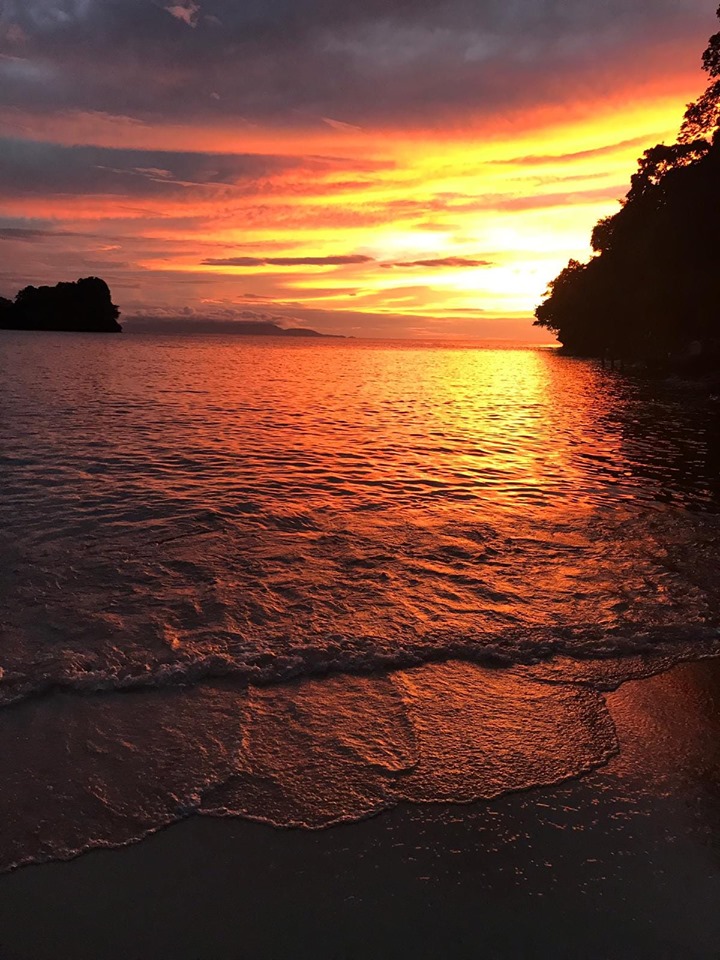
|
|
- SAL Dust Outbreak!
|
- By Matthew de Sousa <mattdesousa1994 at gmail.com>
- Date: Tue, 14 Jul 2020 10:06:32 -0400
|
Good day everyone! Much of the Lesser and Greater Antilles are being pummelled by this latest surge of dust and as expected, this will put a lid on tropical development for the time being until probably late July into August. Have a fantastic week everyone!
- Matthew 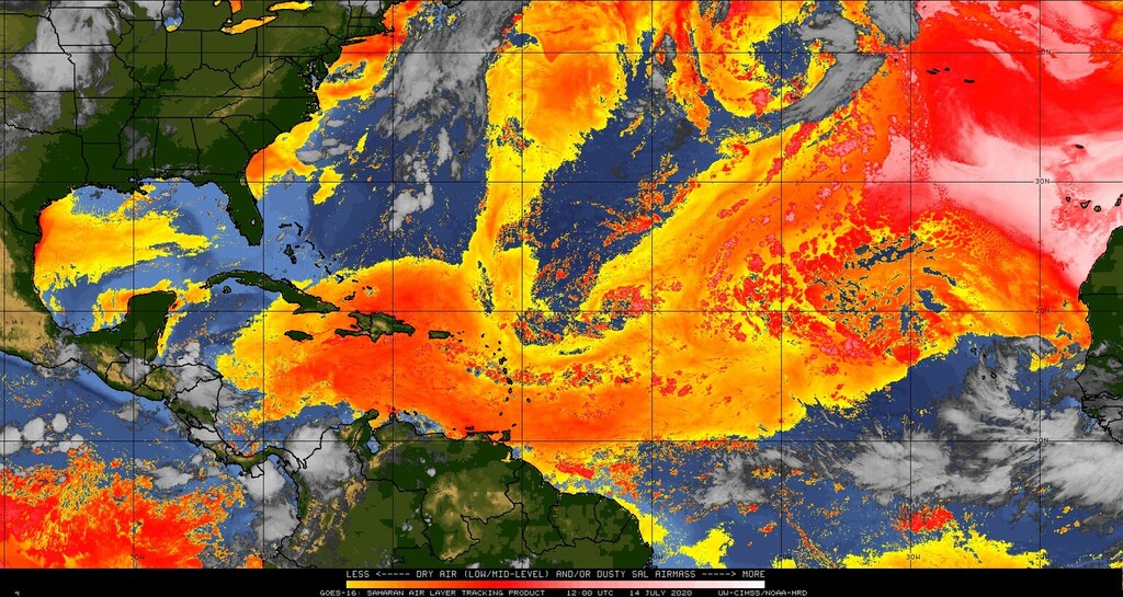
|
|
- Latest on 'My Take' -
|
- By Ian Martin Borde <readkrox51 at gmail.com>
- Date: Tue, 30 Jun 2020 13:56:15 -0400
|
I am sorry this post is all about a blob.
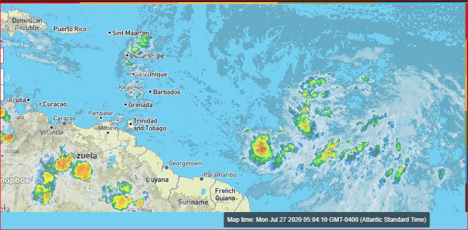
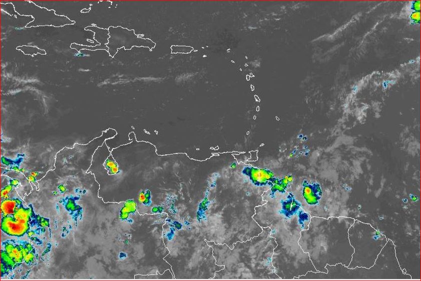
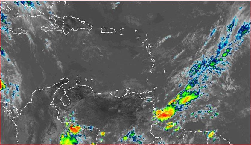
When I checked at eight o'clock. Circulation started at seven o'clock. Currently (my take) the centre is at 15N. 55W. At 15N. it has run into deep SAL. Therefore all precipitation is south of 15N. Precipitation (over one inch) stretches for almost 400 miles. At exactly midday rain fell where I live. More rain 75 miles east of Manzanilla, Trinidad.
The SAL is not going to clear up. So let's see how strong or rather weak it is.
God Bless 

|
|
- TW exiting ITCZ - Beware -
|
- By Ian Martin Borde <readkrox51 at gmail.com>
- Date: Mon, 29 Jun 2020 23:03:19 -0400
|
Good Night, Good Day, People of Paradise,
Getting straight to the Point; The TW mentioned at midday Monday, (today) at 50W. has not slowed down. It was moving fast. But, What is going to be 'The Centre of Circulation' is still at 50W. at 10:45pm. The imps of this exiting TW are still on schedule for Tuesday (around midday). I was going to headline this post as: - Beware - Rapid Intensification & Climate Change - but that's not how we do things at stormcarib. Further: This possible 'Centre of Circulation' is bordering at 12N. 50W. which is 02 degrees higher than Trinidad. Or where it was.
If we are doing Preparedness Preparations. Then, One cannot underscore enough one of the measures. Monitor the System ! I repeat, Monitor the System ! From no later than early Tuesday morning.
God Bless 


|
|
- TW tomorrow afternoon till Wednesday
|
- By Ian Martin Borde <readkrox51 at gmail.com>
- Date: Mon, 29 Jun 2020 12:44:47 -0400
|
Brief Notice:
While we are currently having inclement weather due to a 'Blob' over us at 12:30pm. Monday. It is just a typical lunchtime blob embedded in ITCZ without circulation or less than one inch of rain.
Tomorrow's midday shower if there is direct impact will have two inches of rain (maybe slightly more). This TW embedded in the ITCZ will last more than 24 hours. However; - It is in the ITCZ (no circulation as yet). - There is Sahara Dust ( little but there). - There is Wind-Shear.
Note: During Relief Efforts due to Saturday's Storm, or in any Emergency. Don't criticize or complain, but comply. 1) They are skilled workers with emergency equipment. 2) They are risking their lifes. 3) Some of them are leaving disasters of their own to help you.
Just saying,
GOD Bless 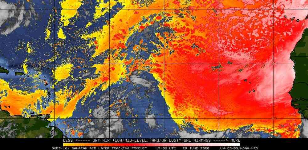
|
|
- Direct Impact from 'Freak' TW
|
- By Ian Martin Borde <readkrox51 at gmail.com>
- Date: Sat, 27 Jun 2020 09:54:50 -0400
|
Trinidad is winding down during a Direct Impact.
Authorities are already out working on Recovery.
Icacos and Tobago least affected.
See attached.
God Bless 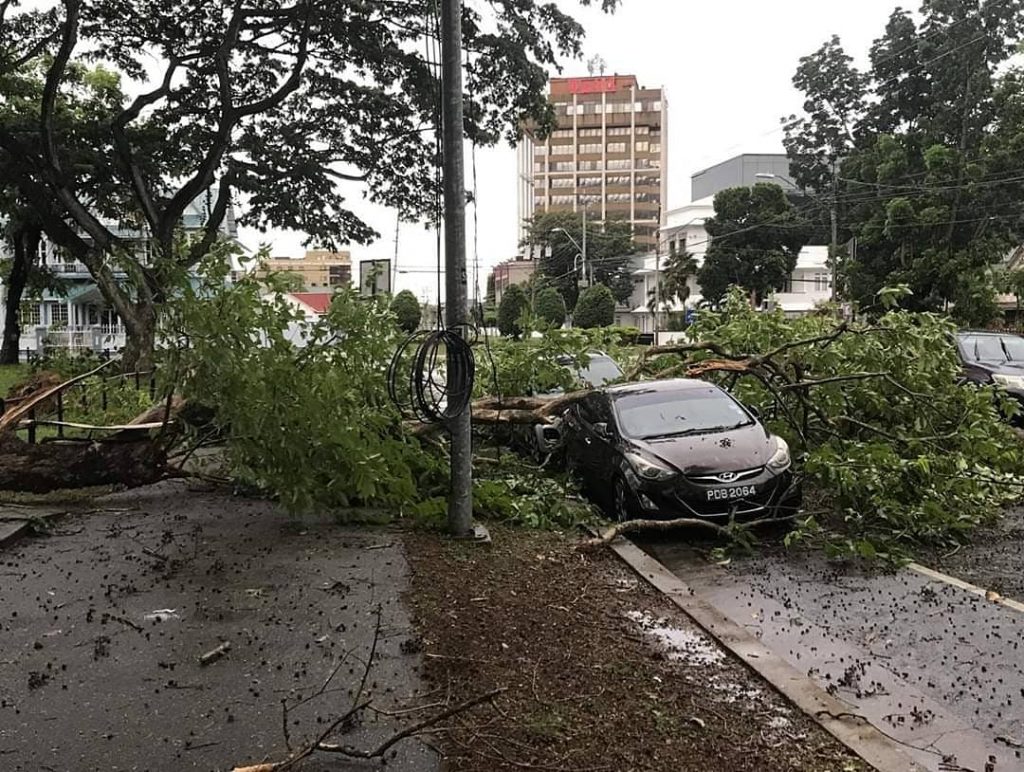
|
|
- Interim Report -
|
- By Ian Martin Borde <readkrox51 at gmail.com>
- Date: Wed, 17 Jun 2020 16:29:24 -0400
|
It will still be Hazardous Tonight !
But !!!!!!
And the point is: 1) The main system is west of us. (4:00pm.) 2) There seems to be nascent circulation west of T&T. 3) Over water, directly heading for Margarita, (hardly inland). Even if it stops for 36 hours after lunch tomorrow. There is another southerly wave right behind. 4) Toco/Valencia had the most rainfall. 5) The entire twin-island had more than one inch of rain.
Waiting for Damage Reports, . . .
Shouldn't be much ???
God Bless |
|
- Incoming Tropical Wave!
|
- By Matthew de Sousa <mattdesousa1994 at gmail.com>
- Date: Wed, 10 Jun 2020 21:46:18 -0400
|
Good evening everyone! The NHC has tagged a Tropical Wave east of the Windward Islands with a 10% chance of development over the next 48 hours to 5 days.
There's a substantial amount of Saharan dust and strong upper level winds affecting the wave so further development isn't expected but we could receive some heavy rains and gusty winds tomorrow (Thursday) going into the night. I'm of the opinion that the T&T Met Office might issue an Adverse Weather Alert sometime tonight or tomorrow morning just to be safe but nevertheless, it looks like we're in for a wet Corpus Christi holiday!
Have a good night everyone!
- Matthew 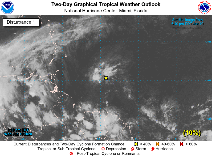
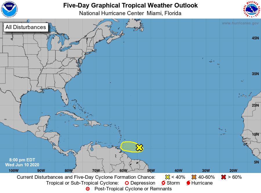
|
|
- Corpus Christi -
|
- By Ian Martin Borde <readkrox51 at gmail.com>
- Date: Mon, 8 Jun 2020 16:53:37 -0400
|
There is a more Northerly Blob tomorrow. The Blob itself, plus windshear and SAL, makes it ineffective except for supply of water.
Spiritual Holidays have Temporal Value. Corpus Christi (Thursday) is a season for Planting/Sowing.
It is also the most Significant Day of Reopening the Economy.
In other words, "It always 'rains' for Corpus Christi."

|
|
- All (Almost) Clear -
|
- By Ian Martin Borde <readkrox51 at gmail.com>
- Date: Sat, 6 Jun 2020 06:23:47 -0400
|
For the sake of The Recovery Economy,
Even though there will be an ongoing 'drizzle' for 2 - 3 more days. The Brilliant, National - Restraint & Precautions - deem it also necessary to consider that the 'bad' weather has cleared up !!! Congratulations T'dad & T'bgo of taking a cut-throat 2020 Year and managing to begin, to start, to work on bouncing back.
May GOD continue to 'Bless', all in The Caribbean, . . . !!! 
|
|
- Incoming Tropical Wave
|
- By Matthew de Sousa <mattdesousa1994 at gmail.com>
- Date: Thu, 4 Jun 2020 18:25:12 -0400
|
Good evening everyone! It seems that both islands are in for a bit of possible adverse weather to close off the work week from an incoming Tropical Wave. This approaching wave has prompted the local Met Office to issue a Yellow Level Adverse Weather Alert which in the past has been kind of hit and miss but this wave looks like it'll indeed bring a hefty amount of rain. Don't forget your umbrellas tomorrow trinis!!
- Matthew 

|
|
- TW next 12 - 72 Hrs.
|
- By Ian Martin Borde <readkrox51 at gmail.com>
- Date: Thu, 4 Jun 2020 14:27:37 -0400
|
Good People of Paradise,
There are mangoes, cherries, bananas (plantain & fig), two Public Holidays, more COVID Reopening this June.
There is also the first Blob to pay attention to !
Scientific ENOUGH, but not actual Data says;
Waves over 6' (ft.) Winds bordering on 20 - 25 mph. Precipitation, definitely over one(01") inch.
The Pink and Yellow gigantic tree synonymous with the beginning of The Wet Season is called 'Poui' locally.
God Bless 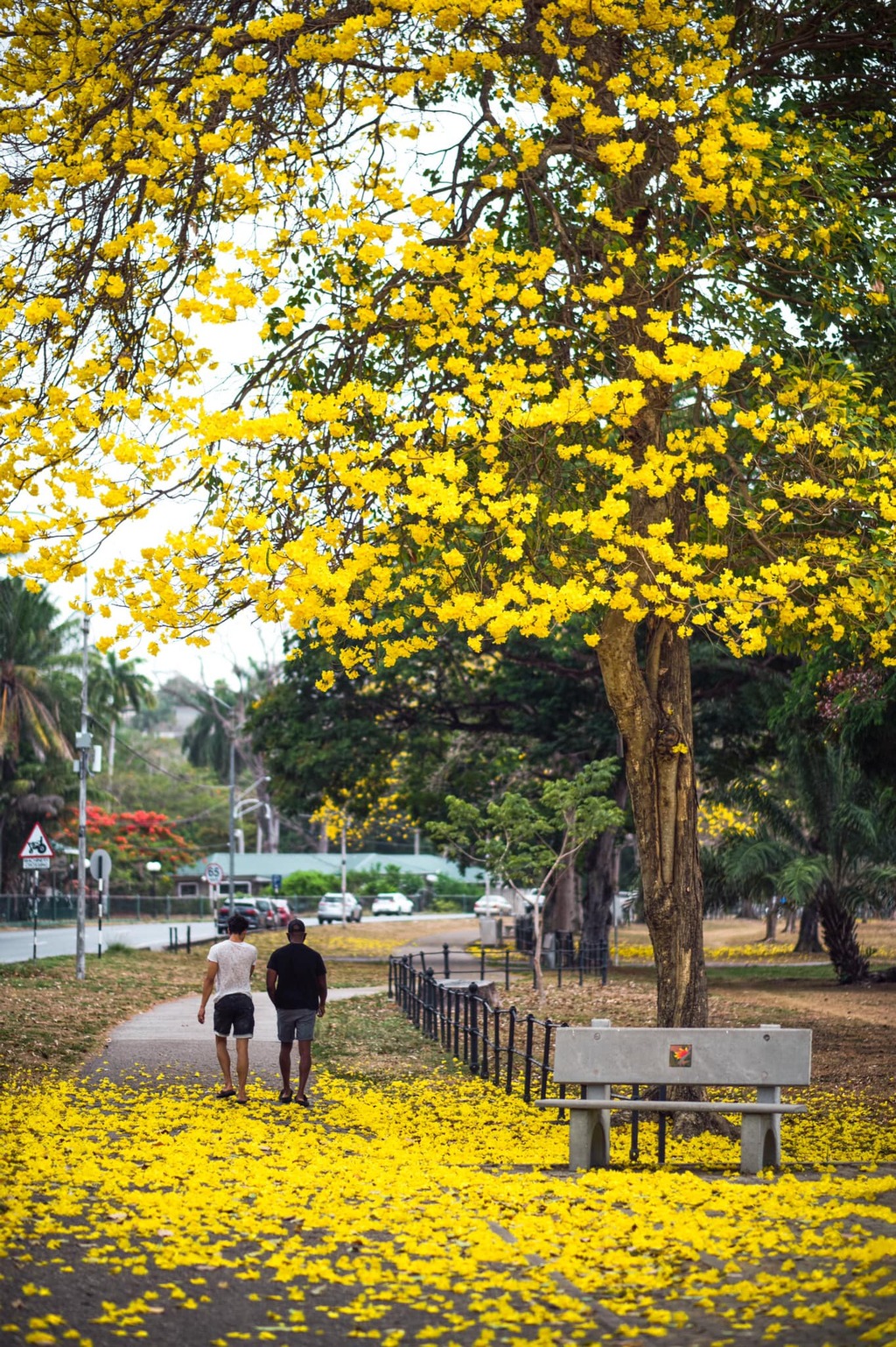

|
|
- Good day everyone!!
|
- By Matthew de Sousa <mattdesousa1994 at gmail.com>
- Date: Sun, 31 May 2020 11:32:28 -0400
|
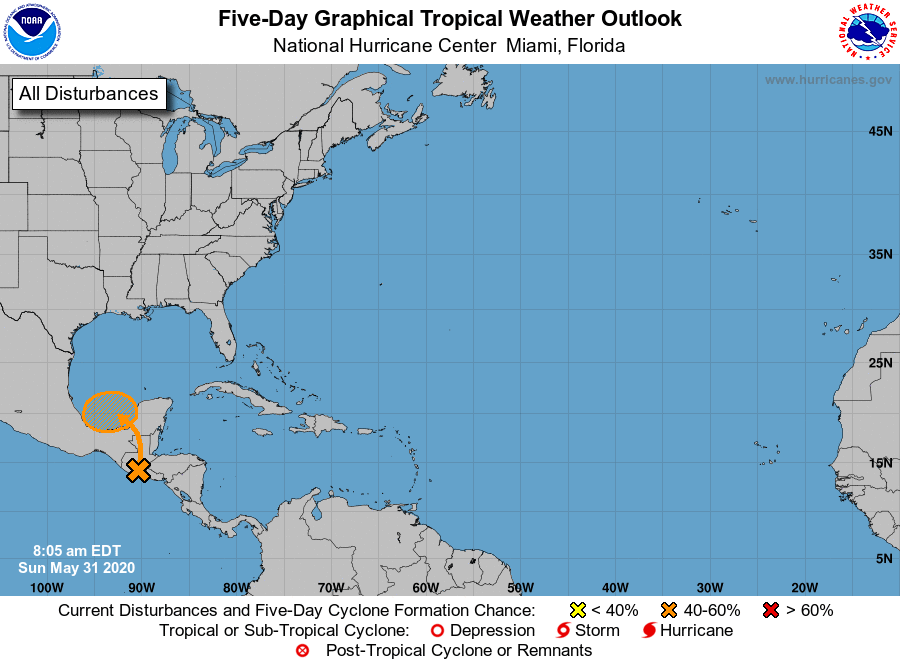
We're only about just over 12 hours away from the official start of the 2020 Atlantic Hurricane Season and we're already two storms in and with another area of interest marked for possible development but this one is rare.
As I type this, TS Amanda is currently impacting portions of Guatemala and El Salvador. Amanda is forecast to dissipate over the mountainous terrain of those areas tonight but then possibly regenerate in the Bay of Campeche and possibly strengthen back into a TS but be designated with the name Cristobal seeing as the system reformed in the Atlantic basin.
I have a hunch that this hurricane season just might one for the record books I reckon!! We'll just have to wait and see.
Have a good day everyone!!
- Matthew 
|
|
- Blob Tomorrow -
|
- By Ian Martin Borde <readkrox51 at gmail.com>
- Date: Mon, 25 May 2020 20:02:33 -0400
|
The Tropical Wave Hogan spoke about is coming tomorrow.
This second one is more southerly. It is already impacting the Guyanas. Windshear and SAL is not a hindrance.
It is a non-event but treat all as if they will stall over the Caribbean.
Blessings Flow 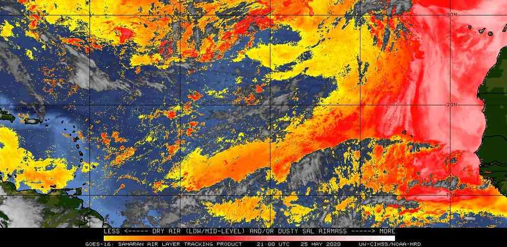


|
|
- Still Waiting -
|
- By Ian Martin Borde <readkrox51 at gmail.com>
- Date: Wed, 20 May 2020 19:14:43 -0400
|
2020-05-20th
1st Tropical Wave :
I am still waiting but being SILENT & PRUDENT, ... ! Without knowing me, a thousand guesses will be, Mostly Correct. It can be summed up as. I am waiting for 'Good Common Sense' to Prevail.
Weatherwise: We have the first tropical wave/blob for the 2020 Wet Season. Based on links Dave and Gert provided in the right-hand column. I see, Winds, above 15mph. Seas, less than 10ft. Precipitation, Marginally over one inch in Dominica and Martinique. Maybe Guadeloupe, then Monsterrat, St. Kitts, Nevis area and then St. Thomas area.
COVID-19 & T&T; Tomorrow over one-third of the 'Recovery' Economy will 'Reopen'. All Emergency Travel was accomplished weeks now. UWI Students will be next to Travel. (Maybe Cruiseship Workers???) Exams and Online Education/Academics, like a 'toddler', is making new and shaky PLEASANT AND SATISFYING Steps Forwards. NO NEW CASES for 21 Days, ... ! (In the Name of Jesus, ... !) My Daughter is a Final Year Undergraduate.
But, I'm Still Waiting. Please GOD!
( I mean it's Obvious?)


|
|
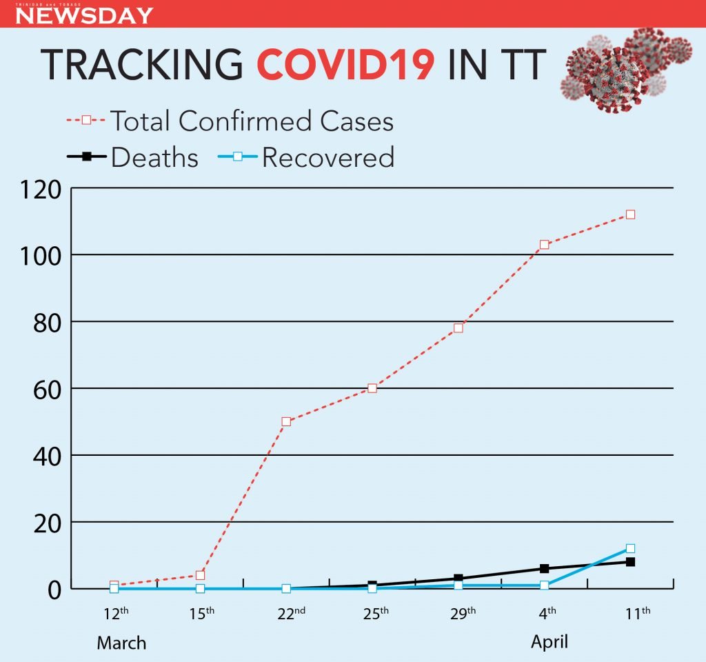
- T&T, ... , Flatten The Curve -
|
- By Ian Martin Borde <readkrox51 at gmail.com>
- Date: Sun, 12 Apr 2020 21:55:51 -0400
|
The NEXT TWO WEEKS are VITAL in T&T!
STAY HOME
for Two More Weeks.
(Then ?Maybe? we will have academic exams in May/June and Emergency Travel.)
REMEMBER: RESTRICTIONS ad infinitum, TILL WE HAVE A CURE AND TREATMENT.
[ref: (retired) RC51-Ian M. Borde]


|
|
