|
|
- - - 2019 Hurricane Season - - -
|
- good morning
|
- By Barbara Cannegieter <barcann at hotmail.com>
- Date: Sat, 21 Mar 2020 14:01:43 +0000
|
|
It's a rainy, cool, windy morning in St Maarten. And we are all in our homes trying to stay safe from COVID-19.
|
|
|
- Saharan dust
|
- By Barbara Cannegieter <barcann at hotmail.com>
- Date: Fri, 21 Feb 2020 14:07:25 +0000
|
Good morning from St Maarten.
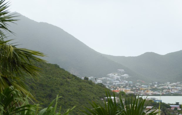
This picture may look like it’s raining but it’s not.
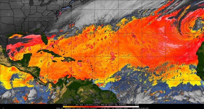
This is Saharan dust currently affecting the island and surrounding area.

The other attached image shows the SAL layer.

It is early in the season for such an influx of Saharan dust. If you have allergies or respiratory problems, please take care.
Sent from
Mail for Windows 10
|
|
|
- Farewell Miss Mermaid
|
- By Barbara Cannegieter <barcann at hotmail.com>
- Date: Mon, 17 Feb 2020 13:37:10 +0000
|
Just reading about Miss Mermaid who passed away in December. I was sad to hear the news.
She was a well known Caribbean blogger and a hurricane correspondent here on Stormcarib for many years.
I think words such as quirky and free spirit best describe her for those of you who have never read her blog or her stories here. She brought amazing stories of Caribbean life to many.
Rest in Paradise, Miss Mermaid.
Sent from
Mail for Windows 10
|
|
|
- Hello Statia!
|
- By Barbara Cannegieter <barcann at hotmail.com>
- Date: Sat, 30 Nov 2019 22:34:26 +0000
|
|
hi everyone
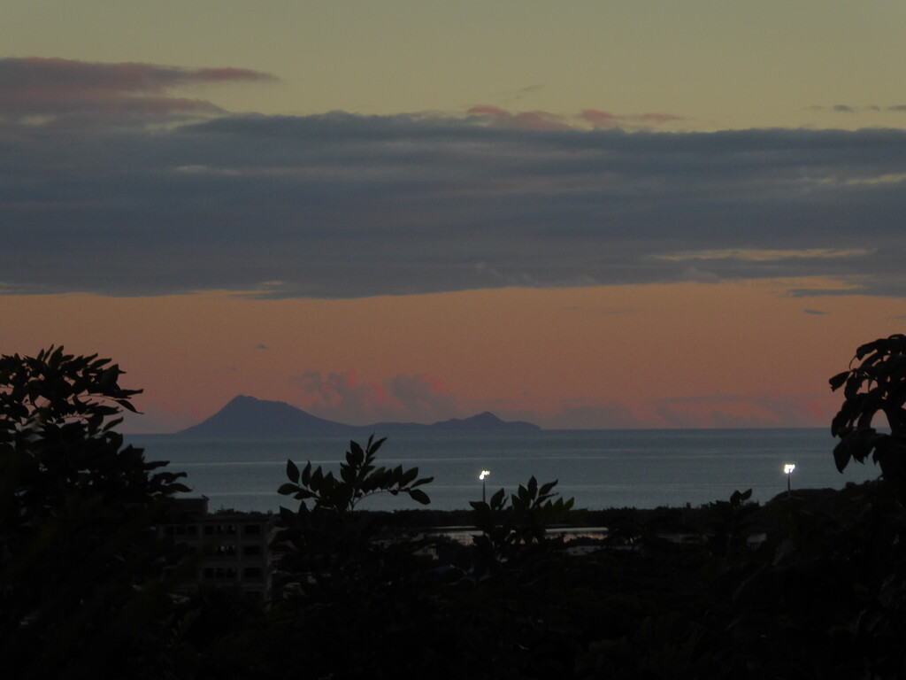
Here is a picture I just took from my porch. The visibility today is outstanding.
I can't always see Statia so clearly.

|
|
|
- It's all over until next year!
|
- By Barbara Cannegieter <barcann at hotmail.com>
- Date: Sat, 30 Nov 2019 19:56:33 +0000
|
|
November 30th, the end of hurricane season. We can relax for a few months before it starts again.
Today in St Maarten it is partly cloudy with not much wind and the visibility is excellent. I love this time of year in the Caribbean.
The attached image is Philipsburg, with 2 ships in port and Saba in the background. We can't always see our neighbor Saba but we can today. The image is a screenshot from
https://www.portstmaartenwebcam.com/
|
|
|
- Karen, go away!
|
- By Barbara Cannegieter <barcann at hotmail.com>
- Date: Wed, 25 Sep 2019 14:56:31 +0000
|
|
Good morning
Tropical storm Karen continues affecting us. it was a calm night but this morning out of nowhere there were gusty winds and heavy rain.
It's just cloudy now.
We are grateful it hasn't been worse, and hope that PR fared OK.
Our main town of Phillipsburg faces South. There is a boardwalk running along the beach lined with beach bars and restaurants.
It's quite a mess there this morning due to the high waves.
There are tons of seaweed to clean up.
These pictures were taken this morning by a friend of mine.
|
|
|
- windy and squally
|
- By Barbara Cannegieter <barcann at hotmail.com>
- Date: Tue, 24 Sep 2019 13:46:50 +0000
|
Good morning
Tropical Storm Karen is passing to our west.
Met Office keeps saying we can get some heavy rain but so far we have just had squalls with light rain. It's very breezy here and the wind picks up quite a bit during those squalls.
The sea is very rough.
School is cancelled on the island just in case. The roads leading to many of the schools are very easily flooded.
I know we are only lightly being touched by Karen and for that we are grateful.
The flooding in Trinidad and Tobago was terrible and I know PR and VI are going to get much more bad weather than us.
So please be safe everyone.
The picture is from PTZtv camera at Philipsburg.
|
|
|
- Hurricane Jerry passed us with only a whimper
|
- By Barbara Cannegieter <barcann at hotmail.com>
- Date: Sat, 21 Sep 2019 12:31:01 +0000
|
|
Good morning
The sun is shining and people on St Maarten are getting back to normal.
Jerry caused us no problems except for high seas which did flood the boardwalk in Philipsburg.
Other than that, no rain and no wind.
Now I start watching once again the waves that are crossing the Atlantic.
But not today! I am taking a day off from the weather.
Have a good weekend everyone
|
|
|
- Dead Calm zero wind
|
- By Pelican <sxmwx at miwww.com>
- Date: Fri, 20 Sep 2019 18:51:19 -0400
|
Since around early afternoon the wind has died down completely, must
be something to do with Jerry sucking up all the air. The sea looks
like a table, except for some swells that where coming in late
afternoon and causing some decent waves at the rocks near Flamingo resort.
At the Windy.com wind flow animation one can easily spot an area
south of Sint Maarten that also encompasses Saba and even St Kits as
well where there is almost no circulation. Since yesterday Windguru
was predicting very light breeze between 3-6 maybe 8 knots. Looked
like an error given the circumstances, but they nailed it for sure.
Since the 3pm rain not a drop more. The frogs are signing outside and
Jerry is moving on, hopefully into open waters. Got lucky this time,
but more is on the way.
Alex at Pelican Key
|
|
- Very rainy Friday morning + Thunder
|
- By Pelican <sxmwx at miwww.com>
- Date: Fri, 20 Sep 2019 15:26:19 -0400
|
Woke up this morning around 5:30am to persistent heavy rains and
extremely close and loud thunder, less than a second between the
flash and the sound. Then noticed my DSL router not showing any
signs of life. After a forensic analysis a surge seems to have gotten
into it mostly through the phone line cable as shown by burned up
components. So much for all the internal protection of the router.
Had to go get a new one, fortunately all went well as the ISP had
them in stock, so I am back up and running since mid morning.
Its now 3pm and the sky is starting to show a lot of dark clouds.
Earlier had a ~5 minute "good size" rain, but it has stopped now.
Guadeloupe radar is showing a couple of rain specks passing by our
area, so I guess that's what it was. Also on the radar seeing some
substantial higher rain activity towards Antigua, although it only
looks like rain bands passing by.
Lots of complacency here [again] among people I've talked to, and on
the other hand lots of other people taking it more seriously. Guess
some already forgot about Gonzalo 2016 with its last hour cat2
surprise when a lot of persons where caught off guard and only
expecting a TS. Just like now.
So far so good... Prepare for the worst, hope for the best.

Alex  at  Pelican Key
|
|
- Hurricane Jerry approaches
|
- By Barbara Cannegieter <barcann at hotmail.com>
- Date: Fri, 20 Sep 2019 18:44:33 +0000
|
|
St Maarten is hunkered down in anticipation of the arrival of Jerry.
Jerry is expected to pass North of us tonight into tomorrow, but we expect heavy rains.
Businesses have closed down at 2:00 PM.
This link provides updated satellite imagery on the approach of Jerry.
|
|
|
- We are under a tropical storm watch!
|
- By Barbara Cannegieter <barcann at hotmail.com>
- Date: Wed, 18 Sep 2019 21:36:32 +0000
|
|
as per NHC 5 PM advisory:
CHANGES WITH THIS ADVISORY:
The government of St. Maarten has
issued a Tropical Storm Watch for
St. Maarten.
Meteo-France has issued a Tropical
Storm Watch for St. Martin and
St. Barthelemy.
SUMMARY OF WATCHES AND WARNINGS IN
EFFECT:
A Tropical Storm Watch is in effect
for...
* St. Maarten
* St. Martin
* St. Barthelemy
The Stormcarib tool how close can it get shows this as of the present track:
Results for St.Maarten/St.Martin (18.05N, 63.12W):
The approximate Closest Point of Approach (CPA) is located near 19.5N,
62.3W or about 114.7
miles (184.5 km) from your location.
The estimated time of when the center of the storm will be at that location is in about 51
hours and 56 minutes from now (Friday,
September 20 at 9:30PM AST).
This is a useful little tool.
https://stormcarib.com/closest.htm
I am still more worried about the one behind it.
|
|
|
- watching TD 10. could come close to the northern islands
|
- By Barbara Cannegieter <barcann at hotmail.com>
- Date: Tue, 17 Sep 2019 15:40:06 +0000
|
Tropical Depression Ten Discussion Number
1
NWS National Hurricane Center Miami FL
AL102019
1100 AM AST Tue Sep 17 2019
Deep convection associated with the area of low pressure over the
central Atlantic has become more persistent and better organized
this morning. Data T-numbers from both SAB and TAFB are 2.0 on the
Dvorak scale, therefore advisories are being initiated on a tropical
depression. The initial intensity is set at 30 kt, in line with the
satellite estimates. The depression is forecast to move over
gradually increasing sea surface temperatures within a favorable
upper-level environment. The only negative factor for
intensification appears to be some nearby dry air, but with low
shear conditions expected, so steady strengthening is forecast
during the next several days. The NHC forecast calls for the
depression to become a tropical storm later today, and attain
hurricane status within 72 hours. The NHC intensity forecast is in
good agreement with the SHIPS and LGEM statistical models.
Since the depression is still in the development phase, the initial
motion is a somewhat uncertain 295/10 kt.
A strong deep-layer
ridge to the north of the cyclone should steer the depression
generally west-northwestward at a faster forward speed during the
next few days. The track guidance is in relatively good agreement
through 72 hours, and brings the cyclone near the northern Leeward
Islands in about 3 days.
By late in the period, the cyclone is
expected to reach the western periphery of the ridge, and there is
increasing spread among the guidance. The global model ensemble
means are along the right side of the envelope while the HWRF and
UKMET are along the left side. The NHC track lies close the
consensus aids, which is also in good agreement with the latest
ECMWF.
Interests in the northern Leeward Islands should monitor the
progress of this system.
|
|
|
- watching 97-L
|
- By Barbara Cannegieter <barcann at hotmail.com>
- Date: Mon, 16 Sep 2019 16:16:14 +0000
|
|
From Crown Weather:
"Invest 97-L Located Halfway Between The Lesser Antilles & The Coast Of Africa (Near 45 West Longitude): An area of disturbed weather, designated Invest 97-L by the National Hurricane Center, is located about
halfway between the coast of Africa and the Lesser Antilles. Satellite imagery indicates that Invest 97-L is becoming better organized with an increase in shower and thunderstorm activity noted. In addition, a low pressure system has formed within the area
of disturbed weather and that low pressure center is gradually becoming better defined.
Analysis of environmental conditions around Invest 97-L indicates that the environmental conditions will be favorable for development and strengthening throughout this week. This means that I think it’s likely that Invest 97-L will become
a tropical depression and then a tropical storm over the next 2 to 3 days or so.
Those of you in the northern Leeward Islands, Virgin Islands and Puerto Rico should keep a close eye on the progress and development of Invest 97-L. At this point, I think it’s likely that this system will
pass to the north of the Leeward Islands on Saturday, but it’s a good idea to keep an eye on this system just in case."
|
|
|
- What a mess it is out there east of us!!
|
- By Barbara Cannegieter <barcann at hotmail.com>
- Date: Sat, 14 Sep 2019 16:19:17 +0000
|
|
this is an excerpt from Crowne Weather Service posted by Meteorologist Rob Lightbown.
His weather analyses for the Caribbean are pretty much spot on.
No one knows what these waves are going to do though so I am keeping close watch.
"Tropical Waves Between The Lesser Antilles & The Coast Of Africa: The area between the Lesser Antilles and the coast of Africa is just a huge mess of westward tropical disturbances that all seem to be competing
with each other.
The first tropical wave is located about 900 miles or so to the east of the Lesser Antilles very near 45 West Longitude. This tropical wave is moving at a quick forward speed and because of this, development
is not expected anytime soon, if ever. This first tropical wave is likely to bring some gusty showers and thunderstorms to the Lesser Antilles on Monday.
A tropical disturbance that is located over the eastern Atlantic in the vicinity of 35 West Longitude is being watched closely for potential development in the coming days. This disturbance is likely to push
westward and probably will become a tropical depression and then a tropical storm next week.
At this point, it looks possible that this tropical disturbance will be guided to the north of the Lesser Antilles by the “wake” left behind by Humberto. All of the model guidance forecast that this seems to be the most probable scenario.
With that said, I am still gong to keep an eye on this tropical disturbance in case we see a further west track than what is being suggested right now."

|
|
|
- Rainy morning
|
- By Barbara Cannegieter <barcann at hotmail.com>
- Date: Wed, 28 Aug 2019 11:39:37 +0000
|
Good morning
It's been raiing on and off all night in St Maarten. Currently skies are cloudy and we can expect showers throughout the day.
We have been lucky on ths one.
Hoping VI and PR will be OK as Dorian moves in that direction.
|
|
- Dorian
|
- By Barbara Cannegieter <barcann at hotmail.com>
- Date: Sun, 25 Aug 2019 13:55:31 +0000
|
|
Good morning!
This is a portion of my latest update from Rob Lightbown at Crown Weather.
Be careful Barbados, St Lucia, and Martinique.
"I think that we are looking at Dorian either remain nearly the same in intensity or strengthen
a little over the next couple of days. This means that I think that Dorian will move right across the island of Barbados as
a 40-50 mph tropical storm on Monday night. The center of Dorian is then expected to move right over the islands of St.
Lucia and Martinique as
a 50 mph tropical storm during Tuesday morning.
Forecast Impacts: Tropical storm conditions, including wind gusts of up to 40-50 mph, locally heavy rainfall and rough seas, are possible on the island of Barbados on Monday night and then on the islands of St. Lucia and Martinique during Tuesday. Given the
very small size of Dorian, the overall area that the storm will impact will be small."
|
|
|
- Stay alert!
|
- By Barbara Cannegieter <barcann at hotmail.com>
- Date: Sat, 24 Aug 2019 14:46:41 +0000
|
|
BULLETIN
Tropical
Depression Five Advisory Number 1
NWS
National Hurricane Center Miami FL AL052019
1100
AM AST Sat Aug 24 2019
...NEW
TROPICAL DEPRESSION FORMS EAST-SOUTHEAST OF THE LESSER
ANTILLES...
SUMMARY
OF 1100 AM AST...1500 UTC...INFORMATION
-----------------------------------------------
LOCATION...10.4N
47.9W
ABOUT
805 MI...1300 KM ESE OF BARBADOS
MAXIMUM
SUSTAINED WINDS...35 MPH...55 KM/H
PRESENT
MOVEMENT...W OR 280 DEGREES AT 12 MPH...19 KM/H
MINIMUM
CENTRAL PRESSURE...1010 MB...29.83 INCHES
WATCHES
AND WARNINGS
--------------------
There
are no coastal watches or warnings in effect.
Interests
in the central and northern Lesser Antilles should
monitor
the progress this system.
DISCUSSION
AND OUTLOOK
----------------------
At
1100 AM AST (1500 UTC), the center of newly formed Tropical
Depression
Five was located near latitude 10.4 North, longitude
47.9
West. The depression is moving toward the west near 12 mph
(19
km/h) and this general motion is expected to continue today.
A
turn toward the west-northwest is forecast on Sunday, and that
motion
is expected to continue through Tuesday. On the forecast
track,
the tropical cyclone is expected to be near the central
Lesser
Antilles on Tuesday.
Maximum
sustained winds are near 35 mph (55 km/h) with higher gusts.
Gradual
strengthening is forecast during the next few days, and the
depression
is forecast to become a tropical storm later tonight or
on
Sunday.
The
estimated minimum central pressure is 1010 mb (29.83 inches).
HAZARDS
AFFECTING LAND
----------------------
None.
NEXT
ADVISORY
-------------
Next
complete advisory at 500 PM AST.
|
|
|
- Hot, hot, hot!
|
- By Barbara Cannegieter <barcann at hotmail.com>
- Date: Sat, 17 Aug 2019 13:13:28 +0000
|
|
Good Morning
Clearly the world is heating up.
Thankfully it's been a quiet hurricane season so far.
But Crown Weather states:
There are subtle signs in the data that suggest tropical development
chances will probably be on the increase during the last week of this month. It appears that by the end of this month we will see the Africa tropical wave train drop southward towards the equator. This shift southward will lessen the amount of dust that pushes
off of Africa and will also place these waves in a more conductive environment for development. The transition towards the equator of the wave train is about 3 weeks delayed this year, but it looks like it is about to happen quite soon.
So stay alert, be prepared and check your local forecasts and your favorite weather sites.
|
|
|
- more rain
|
- By Barbara Cannegieter <barcann at hotmail.com>
- Date: Wed, 31 Jul 2019 12:14:08 +0000
|
|
Good morning
It's another wet morning for St Maarten. After the 5 inches of rain accumulated from 95L the other day, I had another 1.5 inches in my rain gauge overnight from the tropical wave that is pushing through.
Currently it s raining lightly and thundering.
we are under a heavy rain advisory until mid day.
I think I can safely say the drought is over.
|
|
|
- rain update
|
- By Barbara Cannegieter <barcann at hotmail.com>
- Date: Mon, 29 Jul 2019 16:11:48 +0000
|
|
Currently skies are clearing a little. Maybe the worst is over?
What a deluge it has been this morning.
Early this morning before the rain started I emptied my rain gauge. We had received 2 inches overnight.
Then the heavens opened up once again this morning. Currently my rain gauge measure 3 inches more of rain.
There are reports of many roads flooded.
I received a video on my Whatsapp of boys jet skiing on the streets of Marigot on the French side.
and I also received pictures of a landslide in Saba where a huge boulder crashed through the side of a house.
It's been a rough morning out there.
|
|
|
- rain,rain, rain
|
- By Barbara Cannegieter <barcann at hotmail.com>
- Date: Mon, 29 Jul 2019 14:22:12 +0000
|
|
Good morning
According to the latest satellite image on the page, it looks like 95L is right on us.
I can tell you that since morning we have had continuous thunder, lightning, and lots of rain.
We need the rain, but not this much all at once.
There are reports of minor flooding all over the island.
There is minor flooding in my house too.
I have to go put some more towels down.
Have a nice day, everyone.
|
|
|
- update from St Maarten
|
- By Barbara Cannegieter <barcann at hotmail.com>
- Date: Sat, 13 Jul 2019 13:58:12 +0000
|
|
Good morning from St Maarten
It's been very hot and humid in St Maarten for the past few weeks. Everyone is complaining about the heat and worrying about what that will mean for us when we reach the height of hurricane season. St. Maarten is still recovering from Hurricane Irma and another
storm would be a hard blow for us.
But we will think positively.
It does say:
"Total rainfall for the last 3 months was 99.3 mm, this amount was below the normal range (156-253 mm). There was only one day with heavy rainfall (>10mm) within that period. This has been the driest Apr-May-Jun. since 2016 (98.9mm)."
In spite of the low rainfall, our flamboyant trees are blooming beautifully all over the island. We have several in our neighborhood and in our yard.
I have attached some pictures.
Enjoy!
|
|
|
- Update
|
- By Barbara Cannegieter <barcann at hotmail.com>
- Date: Fri, 14 Jun 2019 21:02:49 +0000
|
|
After a couple of months of absolutely no rain at all, St Maarten has finally started getting some showers. The rain has not been very heavy but it's been enough to make the hills green again, and make it feel more like living in a steam bath, and, of course,
bring out the mosquitoes.
Our garden is very happy and the plants we thought were probably dying have suddenly blossomed.
Yesterday I took a picture of our petrea, which is in full boom. it absolutely loves rain.
I never tire of these colours.
|
|
|
- Caribbean remains in a drought
|
- By Barbara Cannegieter <barcann at hotmail.com>
- Date: Fri, 3 May 2019 22:31:08 +0000
|
|
The St Maarten Met Office Newsletter for May has been released.
In summary it says:
"Most of the islands in the Caribbean have experienced low rainfall activity over the past six months to a year. Severe drought has developed and water rationing has begun in Antigua and St. Eustatius. Severe drought has also developed in Aruba, Barbados, Northern
Guyana, Martinique and St. Kitts among others. The alert level for St. Maarten and the most of the Leeward Islands has been upgraded to Warning. A drought warning means drought is evolving therefore management plans should be implemented and water should be
conserved and/or recycled. "
|
|
|
- no rain
|
- By Barbara Cannegieter <barcann at hotmail.com>
- Date: Fri, 5 Apr 2019 13:11:14 +0000
|
|
Good Morning
St Maarten is dry, dry, dry. We need rain badly.
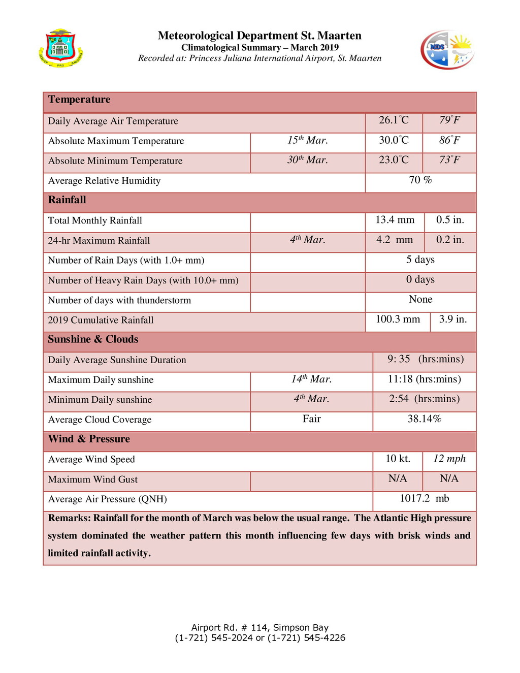
The attached image shows climate information for March.
Rainfall was below average and so far April is looking like it will be the same.

|
|
|

