 |
Climatology
of Caribbean Hurricanes |
|
|
Tobago (TTPT)
Location: 11.15N 60.83W
Tropical systems passing within 60nm (= 69mi.) of the island. Used latitude/longitude coordinates (11.15N, 60.83W) might not be the center of the island. Often the location of the island weather station was used, which is normally at the airport.
Please note that not only hurricanes (h1-h5) are included but also tropical storms (ts). Wind/category reported is maximum measured while the system moved through region (box). Each category storm has its own color (see color bar below; ts=tropical storm; h1=category 1 hurricane; etc., see the guide for definitions). Different projections can be selected, the island projections are most zoomed in (select if you want to see how close the systems passed by the island [not available for regions]), while the world projection most zoomed out (select when you want to see the complete path of the storm). Winds are in miles per hour. It is also calculated how close the center of the storm came to the island, the so-called closest point of approach (cpoa, in miles).
Below you can see all stormtracks for each decade since 1851 for Tobago. All storms since 1851 in one image [colored spaghetti] can be found elsewhere. In the climatology section there is also a weekly analysis of the data which shows when the real peak of hurricane season is for Tobago and a five-year analysis to find out if more storms have passed close by Tobago recently.
Projection: Island | Caribbean | Atlantic | World |
![[ts=tropical storm; h1=category 1 hurricane; etc.]](colorbar.png)
| 2010 - 2019 |
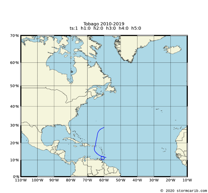 |
    date     wind  cat. cpoa  name
22 Sep 2019    40   ts   59   KAREN
|
|
| 2000 - 2009 |
 |
    date     wind  cat. cpoa  name
 1 Oct 2000    40   ts    9   JOYCE
15 Aug 2004    52   ts   45   EARL
 7 Sep 2004   127   h3   42   IVAN
14 Jul 2005    86   h1   40   EMILY
 1 Sep 2007    52   ts   65   FELIX
|
|
| 1990 - 1999 |
 |
    date     wind  cat. cpoa  name
25 Jul 1990    52   ts   21   ARTHUR
 7 Aug 1993    58   ts   24   BRET
|
|
| 1980 - 1989 |
 |
    date     wind  cat. cpoa  name
14 Oct 1988    52   ts   58   JOAN
|
|
| 1970 - 1979 |
 |
    date     wind  cat. cpoa  name
14 Aug 1974    46   ts   64   ALMA
11 Aug 1978    52   ts   59   CORA
|
|
| 1960 - 1969 |
 |
    date     wind  cat. cpoa  name
20 Jul 1961    58   ts   40   ANNA
30 Sep 1963   104   h2    6   FLORA
|
|
| 1950 - 1959 |
 |
    date     wind  cat. cpoa  name
 5 Oct 1954    63   ts   67   HAZEL
|
|
| 1940 - 1949 |
 |
    date     wind  cat. cpoa  name
17 Aug 1944    69   ts   68   UNNAMED
|
|
| 1930 - 1939 |
 |
    date     wind  cat. cpoa  name
10 Aug 1938    46   ts   32   UNNAMED
|
|
| 1920 - 1929 |
 |
    date     wind  cat. cpoa  name
 8 Sep 1921    92   h1   41   UNNAMED
|
|
| 1910 - 1919 |
 |
    date     wind  cat. cpoa  name
  NO STORMS PASSED BY THIS PERIOD
|
|
| 1900 - 1909 |
 |
    date     wind  cat. cpoa  name
  NO STORMS PASSED BY THIS PERIOD
|
|
| 1890 - 1899 |
 |
    date     wind  cat. cpoa  name
 6 Oct 1892    75   h1    3   UNNAMED
27 Nov 1896    46   ts   25   UNNAMED
|
|
| 1880 - 1889 |
 |
    date     wind  cat. cpoa  name
  NO STORMS PASSED BY THIS PERIOD
|
|
| 1870 - 1879 |
 |
    date     wind  cat. cpoa  name
22 Sep 1877    81   h1   45   UNNAMED
 2 Sep 1878    92   h1   20   UNNAMED
|
|
| 1860 - 1869 |
 |
    date     wind  cat. cpoa  name
  NO STORMS PASSED BY THIS PERIOD
|
|
| 1850 - 1859 |
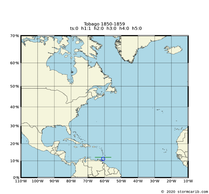 |
    date     wind  cat. cpoa  name
13 Aug 1856    81   h1   65   UNNAMED
|
|
Tobago: all dec peak 5yr rank
Copyright © 2020 Caribbean Hurricane Network. All Rights Reserved