|
|
- - - 2022 Hurricane Season - - -
|
- A few images from Fiona
|
- By John Lawson <j.lawson3 at me.com>
- Date: Wed, 21 Sep 2022 05:45:34 -0400
|
|
Attachment:
Video.mov
Description: QuickTime movie
Attachment:
Video_1.mov
Description: QuickTime movie
Attachment:
Video_2.mov
Description: QuickTime movie
All the Best,
John
|
|
- 5am Report
|
- By John Lawson <j.lawson3 at me.com>
- Date: Wed, 21 Sep 2022 05:41:20 -0400
|
Fiona has left the building!  Well, not totally gone but on her way out.

Unfortunately, Fiona has now grown to a CAT 4 with winds to 130mph.  With luck
she will diminish significantly on her path to Canada.

All the Best,
John
|
|
- Fairly Quiet
|
- By John Lawson <j.lawson3 at me.com>
- Date: Wed, 21 Sep 2022 04:21:05 -0400
|
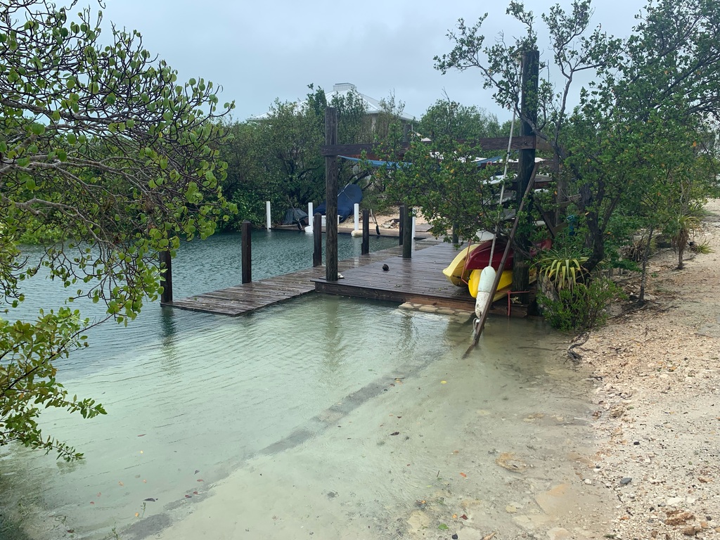
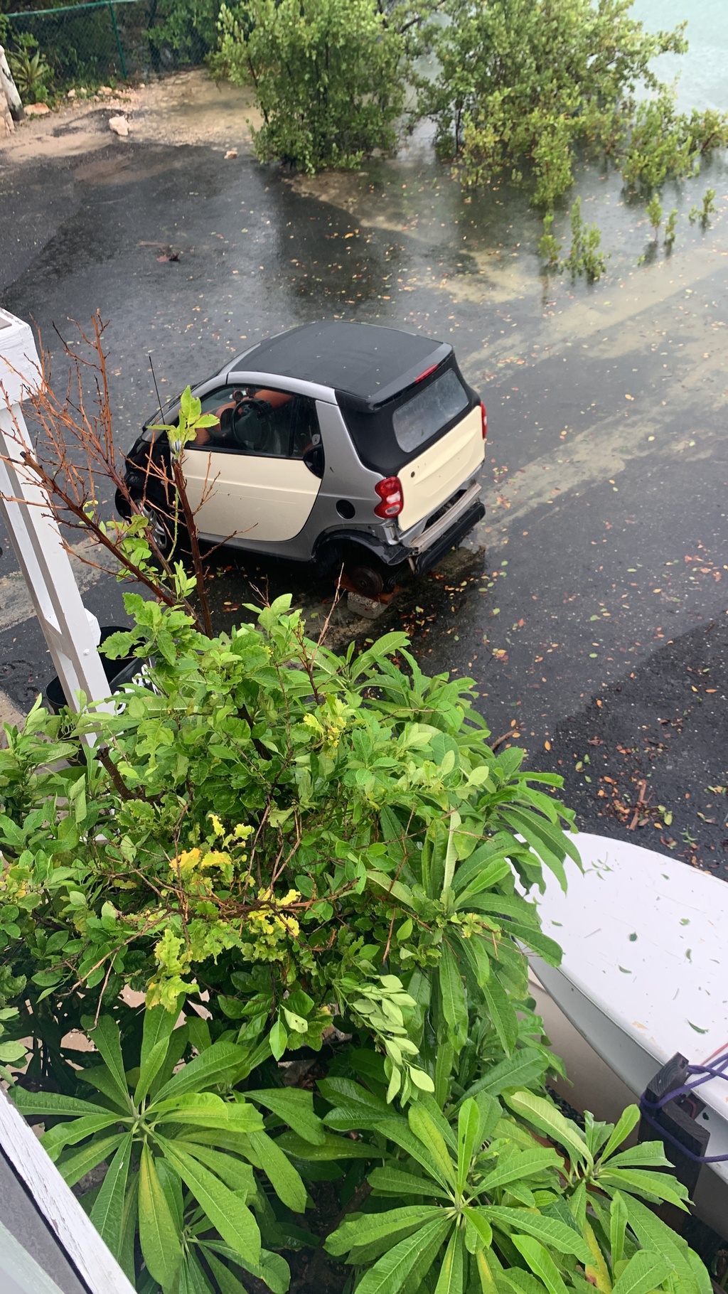
| Hi from Provo (I won’t say good morning just yet! 🤣)
I am up to fire the generator to chill the fridge, pressurize the pump, drain some puddles, and to generally check things out.
The first thing I noticed when stepping outside is the silence. I guess we get used to the constant howling of wind and rain. Of course, there is still the hum of the neighbours generators!
No power yet in Thompson Cove, Blue Mountain and areas of downtown. The outage/s do not affect the whole island and from reports it seems there are only a few areas without power.
Everything is coated in green confetti, the walls, deck, driveway, paths and cars all have a layer of leaf mulch. Despite a lot of green on the ground it seems that we only lost 25% of the leaves in the trees. Lots broken branches, sticks, some wires on the roads. There are large puddles everywhere.
Despite the current, seemingly still, night, the storm is only 100 miles north of us, and there are still outer bands with wind and rain.
I’ll send pictures once it gets light out.
|
|
|
- Quick note -> Thanks Mark
|
- By John Lawson <j.lawson3 at me.com>
- Date: Tue, 20 Sep 2022 12:20:10 -0400
|
Keep in mind that as the eye of the storm passes us over the next few hours, the wind direction will also change. The animated graphic (sent to me by Mark, thanks!) below illustrates this well. This is important as the side of your house (or where ever you are) that is sheltered now, could become the windy side.
For example, I have a door open and I have been going in and out the south side exit. I can stand in the open doorway and watch the storm. Soon the weather will be coming from that direction and I’ll have to close down that access.
|
Attachment:
RPReplay_Final1663690058.mov
Description: QuickTime movie
|
|
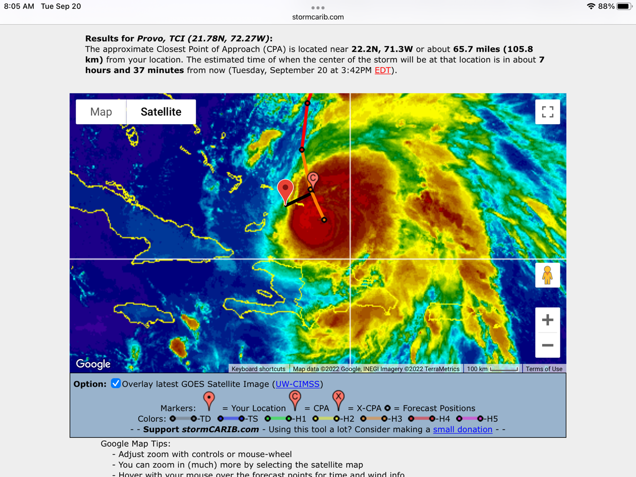
- Now What?
|
- By John Lawson <j.lawson3 at me.com>
- Date: Tue, 20 Sep 2022 11:29:08 -0400
|
| Good Morning from blustery Provo!
Here is my observations based on the 11am update.
Hurricane Fiona is moving away from Grand Turk. I am guessing they are delighted!
The forecast indicates that the center of the storm is now passing us, however a peek at the CPA image below might suggest that we are just entering a very intense wind field and that we might be in it for a while as it seems to be about 100 miles wide.
|
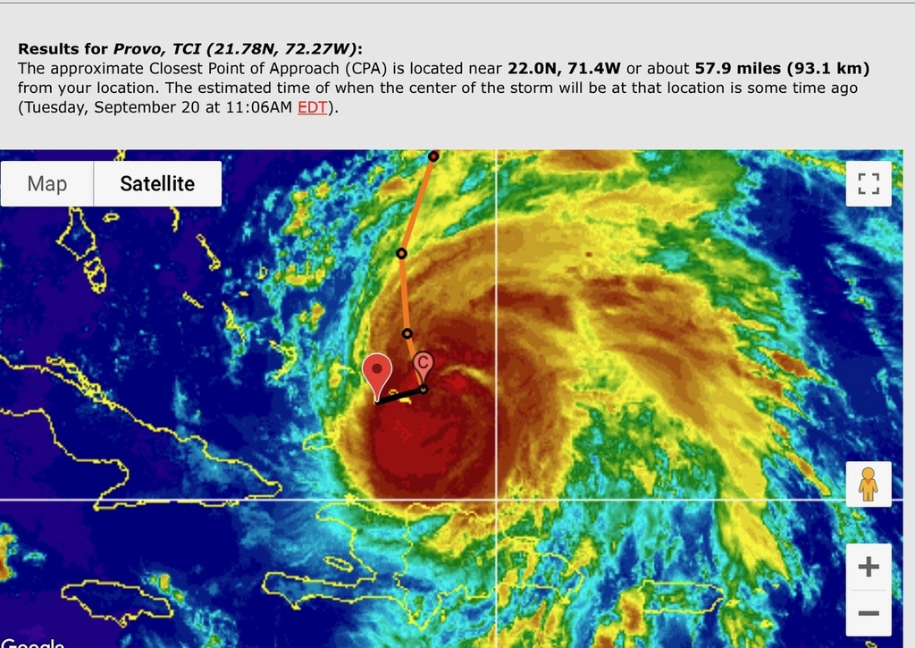
The wind strength has increased, but I am not sure to what. I just know that it is pushing rain into the house through places that do not usually leak. The intense wind is likely to be with us until 10pm or midnight, then start to subside. We should be “back to normal” late Wednesday afternoon.
I have heard reports that some areas of Provo have had power restored. That is pretty amazing! I do not yet have power, so I’ll go out and switch on the generator for a few hours.
Here are a couple of shots I took BEFORE the wind intensified.
|
Attachment:
Video.mov
Description: QuickTime movie
Attachment:
Video_1.mov
Description: QuickTime movie
Now what do I do? A couple of people have asked me if it will be over soon? Not soon enough. The bottom line is that this will be on us until we’ll into the night. Get a good book, or if you are fortunate enough to have power, watch a movie or 5! 🤣🤣🤣
|
|
|
- Update Fiona Provo
|
- By Jimmy and Sharon <piratesofsaltcay at mac.com>
- Date: Tue, 20 Sep 2022 11:22:52 -0400
|
| Morning Provo,
The early morning was mostly rain with gusty winds. Within the last hour winds have picked up with gusts to 45-50 MPH. Sustained wins of about 25-20 MPH in the Discovery Bay area. Power outages are increasing now. Lost power on Discovery Bay area 4am and still out. On generator now. Only 1/2 inch of rain so far but it is increasing hourly. Barometer is 29.46 and dropping. Fiona’s movement is about 10 MPH and if we are lucky we should see a lessening of wind in the next 5-6 hours. Stay Safe and inside.
Best of Luck to all.
|
|
|
- Fiona Stops in for Breakfast
|
- By John Lawson <j.lawson3 at me.com>
- Date: Tue, 20 Sep 2022 08:18:59 -0400
|
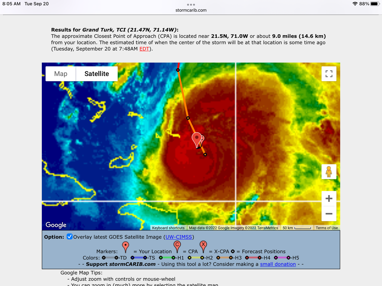
| Good Morning from Provo,
The eye of the storm is about 70 miles away from us. We are currently experiencing gusty winds of about 40mph. That is forecast to increase as Fiona nears us. The wind is currently from the north and will gradually move to the west as the storm passes us. Peak winds seem to be around 12noon today, with the storm set to pass us at about 3pm. The forecast still calls for rain, although I have not seen that yet.
Grand Turk has just gone through the eye, the full force of the storm is upon them now. There is very little communication from Grand Turk as apparently there are both power and telco outages.
South Caicos is on the 30mile hurricane winds field, so it will be getting a lot of wind right now too.
Power is out on North and Middle. Their wind is gusty and should stay within the tropical storm range (less than 74mph)
The power is still out in Thompson Cove (not that I expect anyone to be out fixing it now!). In addition to power outages, there are also telco outages on Provo currently. I can hear the generator chugging which means my first tank of gas is nearing the end.
|
|
|
- Fierce Fiona
|
- By John Lawson <j.lawson3 at me.com>
- Date: Tue, 20 Sep 2022 05:27:52 -0400
|
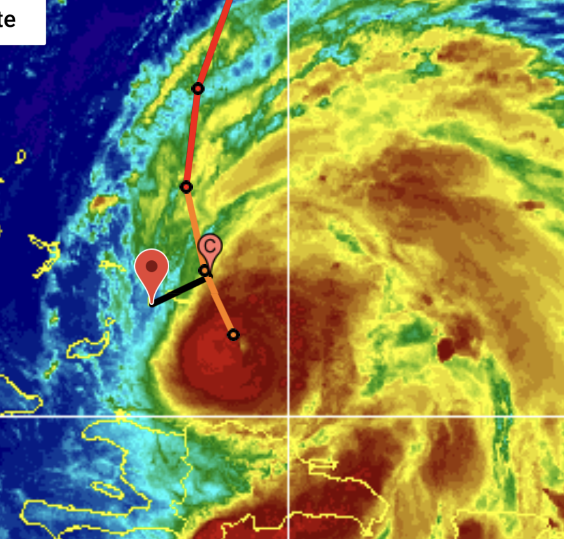
Good Morning from Provo;

Hurricane Fiona has been upgraded to a Cat 3 boasting sustained winds of 115mph.

The center is about 100 miles away.  It will pass us in about 10hours.  At
least it will be light soon and that will make folks feel better for the real
storm.

The wind has certainly increased, however as you can see in the image below, we
aren’t yet in the real storm.  What has caught some peoples attention is the
“tail” trailing after Fiona.  It is still causing havoc in the DR.  Even after
she passes us, her tail will continue to bring wind and rain.

There are a few branches on the road, but really nothing yet.

Sadly for me, the power is out in Thompson Cove.  It is not an island outage.
Stay Safe,
John
|
|
- Provo TCI
|
- By Jimmy and Sharon <piratesofsaltcay at mac.com>
- Date: Mon, 19 Sep 2022 20:39:58 -0400
|
| Hello everyone,
Last time I posted was during Irma when I was on Ambers Cay. Not a good time for sure.
I am now back on Providenciales in Discovery Bay.
John has been keeping you updated about what has been going on recently so here is my latest update.
Sunshine most of the day with a little rain.
Now as of 8:29pm the rain has started. Currently have 0.17 of rain falling at a rate of 1.12 inches a minutes an hour. Wind is 5 MPH in Discovery Bay. Barometer is 29.85 Temperature is 77.
Will update as we go through the night. Fiona is tentatively, hope fully bending more to the North which should lesson the impact on the TCI. Unfortunately our Island sisters, Grand Turk, Salt Cay and south Caicos will be much closer to the storm. Pray for them to keep them safe.
Good luck to everyone and STAY SAFE.
Jim
|
|
|
- Feisty Fiona
|
- By John Lawson <j.lawson3 at me.com>
- Date: Mon, 19 Sep 2022 14:34:46 -0400
|
Good Afternoon from Provo,
Very little change in the 2pm forecast. Provo is still within the tropical storm wind area, Grand Turk and Salt Cay within the Cat2 Hurricane force winds area.
As predicted the DDME has issued a “Shelter in Place” order. Effective 7pm tonight, everyone off the streets of Provo (earlier for the more eastern islands). We are not used to this in Provo, but as more and more people come to our shores, many not familiar with Hurricanes or even storms, it is necessary to limit local traffic to emergency crews, utilities, etc. I get it. I have often loved wondering around to get the “Jim Cantore” live footage, but I won’t do that and you shouldn't either.
The hospital has invoked their “emergency mode”. All non life threatening services are suspended.
The airport closed at 9 am and remains closed.
There is an eerie stillness and silence in the air. No planes, no boats, sparse traffic, just the wind gusts going through our casuarinas! The calm before… possibly.
As the evening progresses, we will start to think of things we should have done. Once nightfall hits, the wind noise will seem louder and we will naturally be more worried than we are at 2pm when it is sunny and quiet. 
I heard from an acquaintance in Higuey, DR. His house was totally wiped out. I understand that there has been significant damage in eastern DR and, of course Puerto Rico. As Fiona heads over the Samana peninsula this afternoon and evening, we will be thinking of those folks directly in the path of the storm. Provo has some awesome construction standards, while the DR does not. We are very lucky.
The path across the Atlantic from the DR to Provo is relatively short. 120 miles. A friend and I just brought a boat across. Unfortunately, this stretch is famous for strengthening hurricanes, and that is what our Fiona will do. Move slow, and gain strength.
By the way, if you find these updates and in fact this site useful, as I do, you should consider making a small donation. These guys operate this site on a volunteer basis, but there are many costs involved. Helping them out, is helping you out. Donate! |
|
|
- Feisty Fiona
|
- By John Lawson <j.lawson3 at me.com>
- Date: Mon, 19 Sep 2022 05:54:57 -0400
|
Good Morning from Provo!
Overnight, Hurricane Fiona’s forecast path has moved west toward TCI and she has plans to intensify. Her forward speed has slowed to 8mph.
Turks and Caicos is now under a hurricane warning.
Tropical Storm force winds extend 150 miles, and the storm will pass us at 86.5 miles. We are well within the Tropical Storm force wind zone and we, in Provo are likely to see 39mph - 74mph winds.
Further, the Hurricane force winds extend out 30 miles, and the storm will pass Grand Turk and Salt Cay at 29.4 miles. Grand Turk and Salt Cay are likely to see CAT 2 and possible CAT 3 force winds.
In terms of timing, in Provo we’ll start to experience Tropical Storm force winds early Tuesday morning (24 hours from now) and this will continue all day with the storm center passing us late Tuesday night. The timing for the easternmost islands is the same for Tropical Storm force winds however they will continue to feel increasing wind and will experience Cat2/Cat3 force winds Tuesday evening. For those easterly islands, the hurricane winds may last 8 or 10 hours.
With the increased wind intensity comes an increase in rain. We are looking at 3” or more in Provo and 6” on the eastern side of the country. Better check your bilge pump! |
|
|
- Just a quick note or two on Hurricane Fiona
|
- By John Lawson <j.lawson3 at me.com>
- Date: Sun, 18 Sep 2022 20:16:11 -0400
|
| Good Evening;
This is a quick update based on the 8pm report.
Sadly for the Turks and Caicos, Fiona has been forecast to strengthen, and move a bit closer.
Hurricane force winds currently extend out 30 miles from the center of Fiona, while Tropical Storm winds extend out 140 miles. According to the most recent report, Turks and Caicos is now about 112 miles away from the center when Fiona passes. If the current forecast path is accurate, we are well within the Tropical Storm force winds, but not in the hurricane force winds area. This means we might see wind up to 39mph.
The westerly trend of Fiona’s path is not good for TCI, especially Grand Turk, Salt Cay and South Caicos. They are the closest to the storms path and will witness more of the storm. |
|
|
- Hurricane Fiona Enroute
|
- By John Lawson <j.lawson3 at me.com>
- Date: Sun, 18 Sep 2022 17:48:21 -0400
|
Good Afternoon from TCI.
We are now under a Tropical Storm Warning, which means the tropical storm conditions (winds 39-74 knots) are possible in the next 36 hours. The winds will build starting now, so every few minutes, we’ll hear a gust that is just a wee bit stronger than the last one. We will likely see a hurricane warning, but TCI is still not likely to see hurricane conditions (winds of 75mph or higher).
Several additional flights have been added this afternoon and first thing tomorrow, to allow folks with Monday or Tuesday flights to get out now. The airport will close at 9am Monday.
A quick trip out to fill a few gas cans and replenish tonic showed no cues and no panic. Of course lots of chat, but everyone I spoke to was taking it in stride and seemed to be prepared.
With the 5pm report, the eye’s path has moved a little closer to us, and a lot more of the storm is now on the east side of the eye. Neither of these developments helps us.
Power is likely to stay on throughout this event, as the utility typically does not shut down the grid until the wind is consistently at 65mph, however, flooding, down lines or problem transformers could shut down power to specific areas at any time.
Monday night (about 36 hours) is when we are predicted to feel Tropical Storm force winds. That is winds of about 40 mph will be felt around 9pm. Of course it will be dark and that will make it seem worse. The rain is predicted to start midday on Monday, with the odd shower earlier. The rain is forecast to last until Wednesday midday with a peak at about Tuesday morning. Keep in mind the rain will come and go. We are currently looking at about 5” of rain, but this changes a lot with each new report.
This is just my personal opinion, but it is my guess that the DDME will issue a “shelter in place” order tomorrow (Monday) just when things start to feel like a storm. At that point the airport, the ferry and roads will be closed until the “all clear” is given. This is a preventative measure to allow the utilities and emergency crews to inspect, monitor and repair anything that may have gone askew, without the unnecessary burden of little cars stuck in puddles along the road. The “all clear” will likely be issued midday Tuesday as the wind subsides and the sun pokes out.
We are all hearing accounts of huge rain, and flooding in the islands already hit by Fiona. We are keeping these folks in our thoughts as we make final preparations for this significant Tropical Storm. |
|
|
- Hurricane Fiona
|
- By John Lawson <j.lawson3 at me.com>
- Date: Sun, 18 Sep 2022 11:40:34 -0400
|
The Closest Point of Approach (CPA) image below, shows the storm turning to the northwest away from us. This is a good trend and we hope is continues! Current we are still on the edge of the track and we expect (and hope for) nothing but a glancing blow. As can also be seen in the image, the “other side” (northeast quadrant) of the storm has more activity than the side that will go by us. This should lessen the impact of the glancing blow. The government and local businesses are taking this seriously. There will be little, if any commercial activity on “Mourning Monday (National Holiday) or “Tempest Tuesday” when the storm will pass us. There have been announcements of airlines putting on extra flights today to take passengers that were meant to fly tomorrow or Tuesday. The airport will close on Monday at 9am and reopen after Fiona has passed and it is safe to reopen. The ferry has suspended trips starting tomorrow. There may be a single trip on Monday morning, but please check directly with the ferry office. 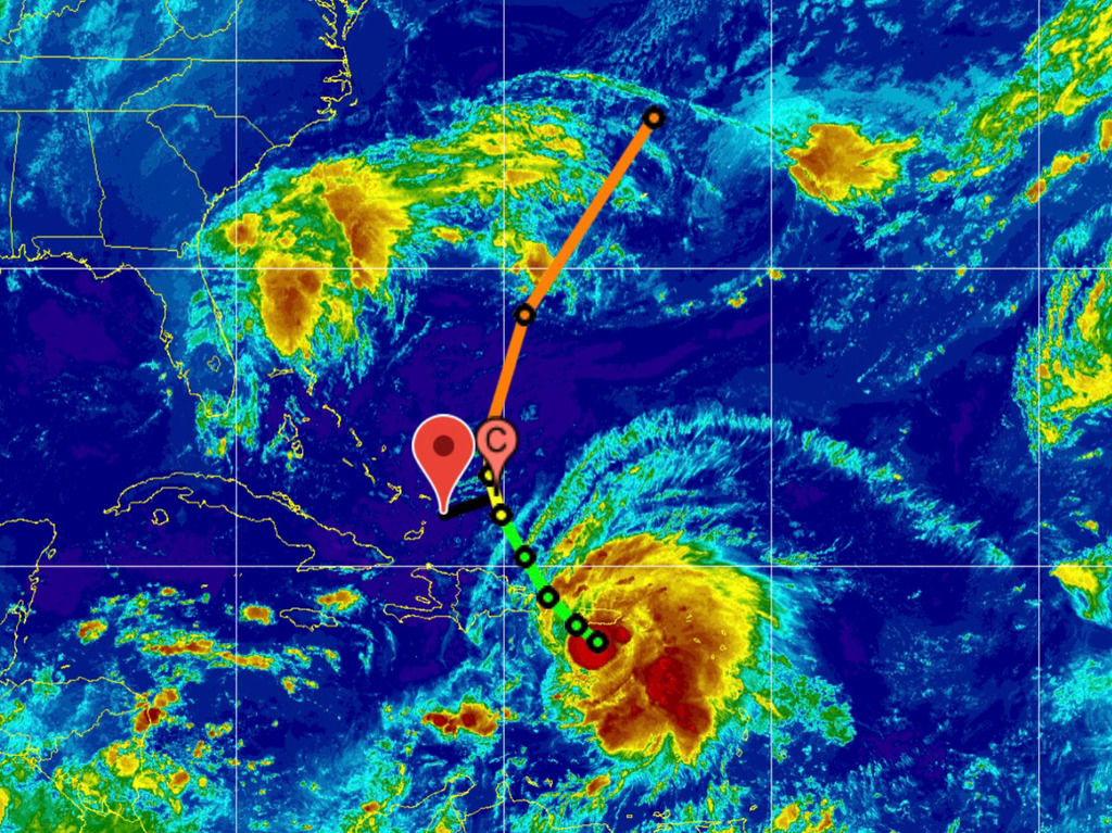
|
|
|
- The Approach of Fiona
|
- By John Lawson <j.lawson3 at me.com>
- Date: Sun, 18 Sep 2022 05:37:31 -0400
|
| Good Morning From Provo, Turks and Caicos!
The 5am report has Fiona passing 126.6 miles to the east, and the tropical storm force winds extending out 140 miles. That puts us just inside. The speed, direction and intensity have varied greatly recently and the impact on TCI is thought to be a lot of rain and 30-40mph wind, but best to keep watching.
The current forecast shows outer bands approaching us Sunday night, with more constant rain starting Monday. Monday afternoon, Tuesday and Wednesday morning look like constant rain. A total downfall of about 5” is the current expectation.
The center of the storm is still over 500 miles away and will pass us in about 60 hours (Tuesday afternoon), however we will start to feel the wind in about 48 hours.
The airport has announced that it will close Monday at 9am. I am guessing that will mess up a lot of flights and make Sunday at the airport quite the “cluster”.
Our government and the supporting organizations seem very ready. The DDME are very keen to showcase their new app, which provides updated info on shelters, flooding, and of course weather. One shelter on each inhabited island will be open today at noon, for details download the DDME app at the App Store. |
|
|