|
|
- - - 2022 Hurricane Season - - -
|
- NOAA Weather Data for Nevis
|
- By H Hallstrom <hwh888 at gmail.com>
- Date: Fri, 3 Mar 2023 08:36:58 -0400
|
Greetings All,
Attached weather station data for the month of February for those interested. Attachment:
02_Feb_NOAA Nevis Weather Data.pdf
Description: Adobe PDF document
|
|
- January NOAA Weather Data for Nevis
|
- By H Hallstrom <hwh888 at gmail.com>
- Date: Thu, 2 Feb 2023 17:04:49 -0400
|
Greetings All,
Attached pdf file for Nevis weather for those interested.
Attachment:
01_Jan_NOAA Nevis Weather Data.pdf
Description: Adobe PDF document
|
|
- October Weather Data for Nevis
|
- By H Hallstrom <hwh888 at gmail.com>
- Date: Sun, 6 Nov 2022 13:05:05 -0400
|
Greetings All,
Attached pdf file for Nevis Weather data for those interested.
Attachment:
10_Oct_2022 NOAA Weather Data.pdf
Description: Adobe PDF document
|
|
- Saturday morning & Fiona
|
- By H Hallstrom <hwh888 at gmail.com>
- Date: Sat, 17 Sep 2022 10:34:04 -0400
|
|
Greetings All,
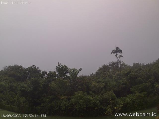
Fiona is still with us but center of storm has passed over the Caribbean chain of islands. Lots of gusty winds and rain showers. It appears more heavy rain in swinging this way from out of the south, back side of storm as it moves away. No sun today and maybe tomorrow as well. Else all is well.
Harry --
Sent via IPhone.
|
|
- NEVLEC Latest
|
- By Frank Goodwill <nevis.storm at hotmail.com>
- Date: Sat, 17 Sep 2022 04:34:58 +0000
|
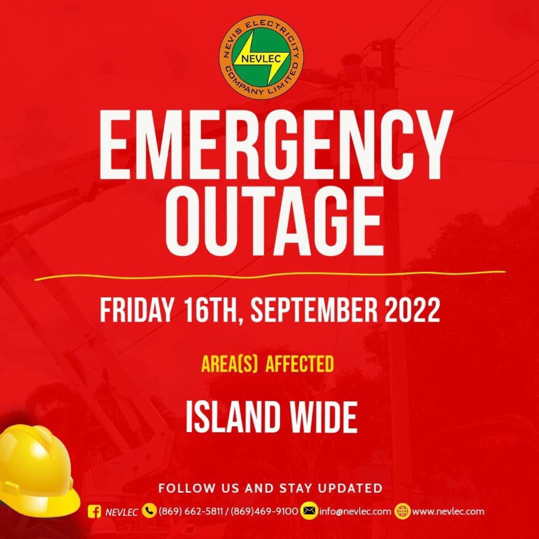
Good night all

Latest from our grid supplier NEVLEC

Dear Valued Customers,

Due to the passage of Tropical Storm Fiona, the NEVLEC Transmission System is
being adversely affected by strong winds and lightning. We are doing our best
to maintain Electricity Supply in all areas. However, as conditions worsen we
will need to curtail supply in order to ensure public safety and avoid
equipment damage.

We encourage all customers to continue to take the usual precautions and stay
safe as the storm passes.

Regards,

Frank Goodwill

Sent from my iPhone
|
|
- T.S. Fiona - power out
|
- By Frank Goodwill <nevis.storm at hotmail.com>
- Date: Sat, 17 Sep 2022 03:16:47 +0000
|
|
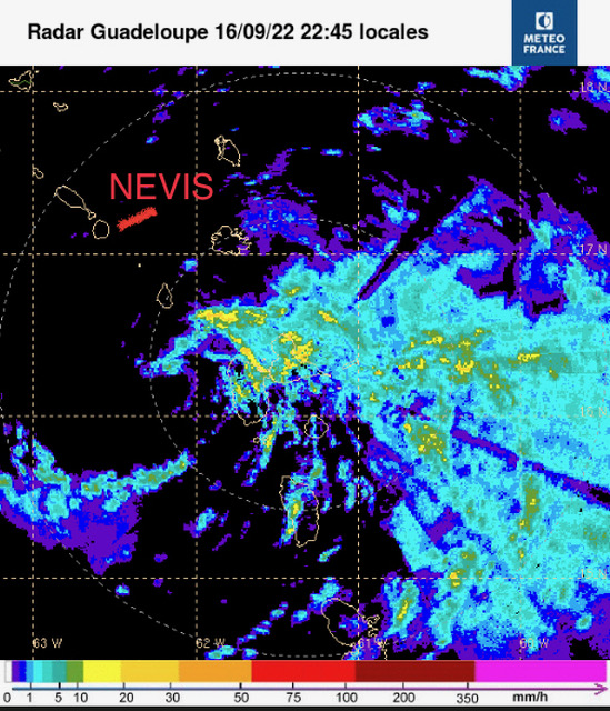
Good night all,
We have an island wide power outage at the moment so any reporting will be limited. Not sure if this is due to the storm though.
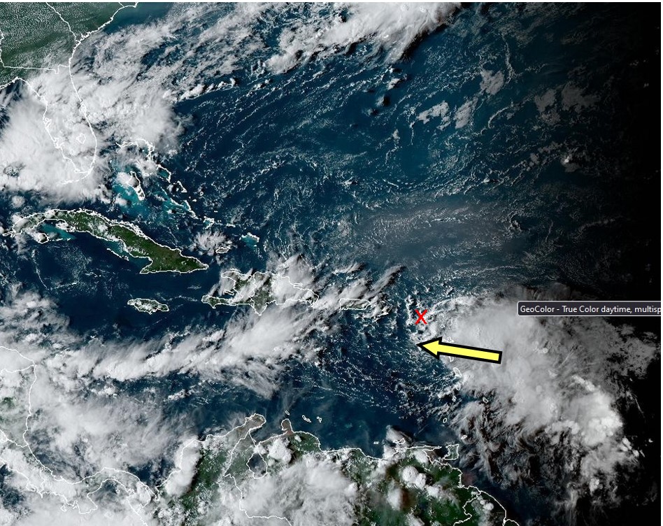
The Meteo France 🇫🇷 Guadeloupe is starting to reveal the rain field to the east of the centre of the storm. Lots of wet stuff! Looks as if the centre of the storm has passed Guadeloupe.
Stay safe.
Frank Goodwill
Sent from my iPhone
|
|
|
- T.S. Fiona
|
- By Frank Goodwill <nevis.storm at hotmail.com>
- Date: Sat, 17 Sep 2022 00:39:37 +0000
|
|
Good night all,
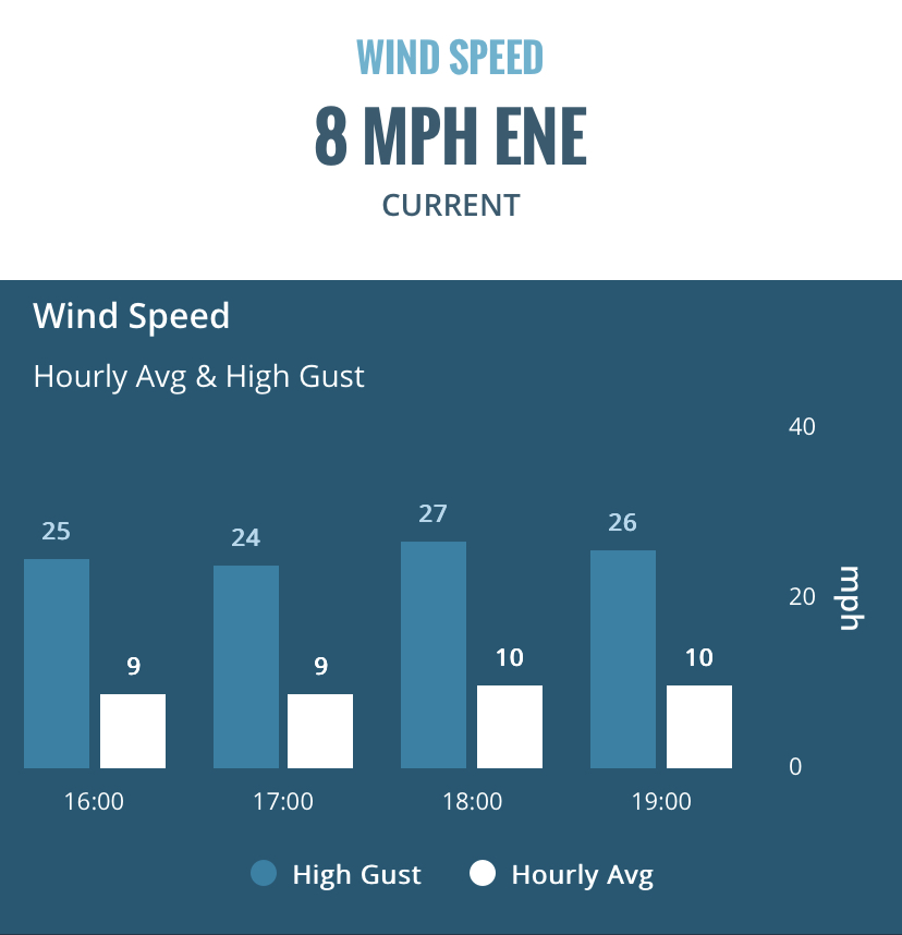
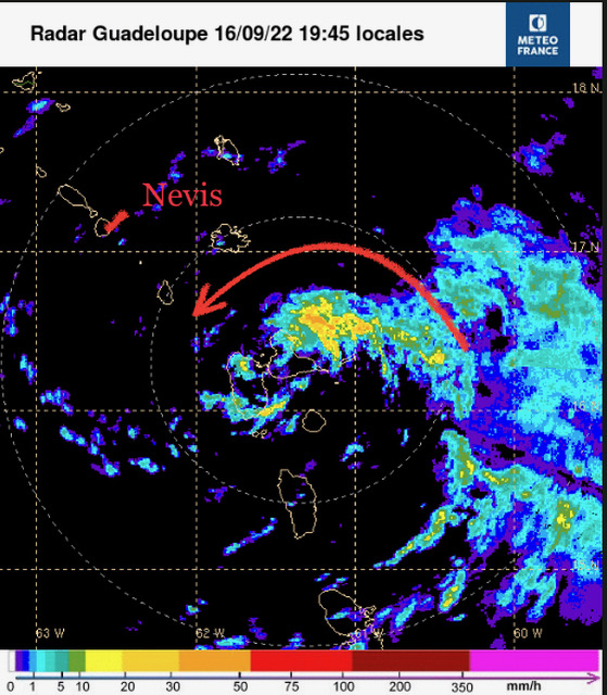
Fiona has had to struggle with wind shear interacting with its front (west) face. As a result it has been a bit ragged. Moving to the west at about 15 mph and centred around Guadeloupe. Today has been cloudy with the occasional shower. Winds haven’t been
to bad (see attached - related to the Hermitage area). Looking at the Meteo France 🇫🇷 Guadeloupe rain radar (see attached), the punch to the storm is on its eastern side. Some of that may be dragged around the northern side by the storms circulation so it
could become wetter later tonight.
More later
Frank Goodwill
|
|
|
- Fiona 5 pm Update
|
- By H Hallstrom <hwh888 at gmail.com>
- Date: Fri, 16 Sep 2022 17:48:16 -0400
|
Greetings All,
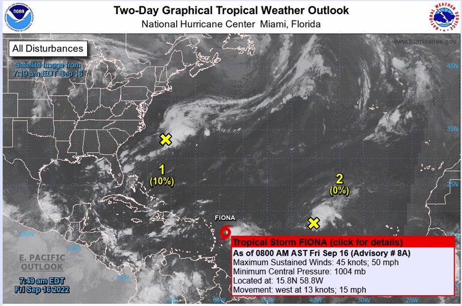
Nothing seems to have changed since last NHC report. All is quiet on Nevis, some showers now & then. A little breeze here & there. The storm pressure is pretty much remaining the same hour to hour. If anything is going to happen, it will be in the nighttime hours.
Tropical Storm Fiona is centered near 16.2N 60.3W at 16/1800 UTC
or 65 nm E of Guadeloupe moving W at 12 kt. Estimated minimum
central pressure is 1005 mb.
|
|
- Fiona 11 am update
|
- By H Hallstrom <hwh888 at gmail.com>
- Date: Fri, 16 Sep 2022 12:02:22 -0400
|
|
Greetings All,
As of the NHC 11am report the westward direction has shifted to a more Northerly direction. The track shifted from 260 deg to 275 deg.
That will move the storm closer to our location, how much? I’ll recalculate after the 3pm report from NHC. The storm radius extends outward approx 75 miles from its center. So I’m guessing we will see windy conditions. The probability charts still remain at 45 mph for us.
Harry --
Sent via IPhone.
|
|
- Fiona Storm 8 am
|
- By H Hallstrom <hwh888 at gmail.com>
- Date: Fri, 16 Sep 2022 09:35:47 -0400
|
Greetings All,
Another look at position and based on last 24 hours tracking the storm is passing even further south of SKB/NEV. Its path has been 260 deg, 10 degrees south of true West. That will place the path over Dominica. Approx 120 miles south of our location.
NHC still predicting 3-6 inches of rain for our area. Hard to see any big 45-50 mph winds for our area. Looks to be more south around Dominica and Guadeloupe.
|
|
- Latest 8 pm Update from NHC
|
- By H Hallstrom <hwh888 at gmail.com>
- Date: Thu, 15 Sep 2022 21:22:21 -0400
|
Greetings All,
Latest data from HNC and a Hurricane Hunter Flight to measure. As of 8 pm Thursday, the storm's center is about 430 miles to our East. Moving at about 14 MPH direct for SKB & NEV. That will put the center slightly South of our islands about Midnight Friday night.
Expect affects well before that time. Being in the Northern quadrant of the storm.
NHC predictions put us in the 41 MPH sustained winds probability zone. They don't show anything greater, but gusts to 50-60 mph are possible.
Expect heavy rains and low level flooding. Can't find any info on projected rain fall amounts. Heavy rains, to me, means 4-6 inches or more. If they appear during daytime hours, STAY off the road. Obviously at night, for sure, stay home.
Will post again at the 11 am NHC report if anything has changed.
|
|
- Friday Rain not the storm
|
- By H Hallstrom <hwh888 at gmail.com>
- Date: Thu, 15 Sep 2022 10:57:35 -0400
|
|
Greetings All,
What you see outside this Thursday is not the storm. There are a band of clouds with rain & lightening preceding the storm.
The now names storm, It was labeled depression Seven yesterday,is now a named storm, Fiona. Is still several hundred miles to our East. Still on track to pass over us.
Stay tuned.
Harry
--
Sent via IPhone.
|
|
- Depression Seven Update
|
- By H Hallstrom <hwh888 at gmail.com>
- Date: Wed, 14 Sep 2022 19:27:37 -0400
|
Greetings All,
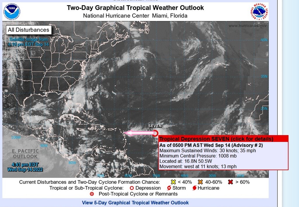
Just had another look at the Atlantic and since last post the depression, #Seven has changed a bit. Its track is now moving west and located 700 nm to the east of the Leeward Islands. Which puts us in its path.
Projected path & time will put #Seven over us Friday morning. Expect windy conditions 35-40 knots. Seas are at present 10-12 feet.
There is a very small area in the NE quadrant registering 50 knots & possible higher. That appears to pass north of our area.
So expect windy and rainy conditions for Friday.
|
|
- Looks like rain coming
|
- By H Hallstrom <hwh888 at gmail.com>
- Date: Mon, 12 Sep 2022 12:56:02 -0400
|
Greetings All,
It looks like rain will be the forecast by this coming end of week/weekend. Indicated path & discussion says windward islands on its present path, but what I see it will be shared between lee wards & wind wards. Doesn't appear to be a storm of any consequence per NHC.
Will have another look mid-week or end of week.
|
|
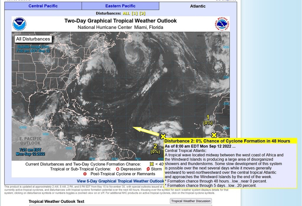
- Latest image of the wide Atlantic
|
- By H Hallstrom <hwh888 at gmail.com>
- Date: Tue, 6 Sep 2022 08:25:36 -0400
|
Greetings All,
The next Disturbance #1 moving off Africa is no threat to our area per report from NHC.
|
|
- August NOAA data from weather station
|
- By H Hallstrom <hwh888 at gmail.com>
- Date: Thu, 1 Sep 2022 17:00:11 -0400
|
Greetings All,
Attached the downloaded data for month of August for those interested.
Attachment:
08_Aug_2022 NOAA Weather Data.pdf
Description: Adobe PDF document
|
|
- Latest Images for SKB & NEV
|
- By H Hallstrom <hwh888 at gmail.com>
- Date: Thu, 1 Sep 2022 16:57:57 -0400
|
Greetings All,
This has to be the slowest moving disturbance ever. Seems like it will never pass us. We are on the very very edge of it. May or may not see much of any rain from this. But a tropical shower can develop any time, disturbance or no disturbance.
|
|
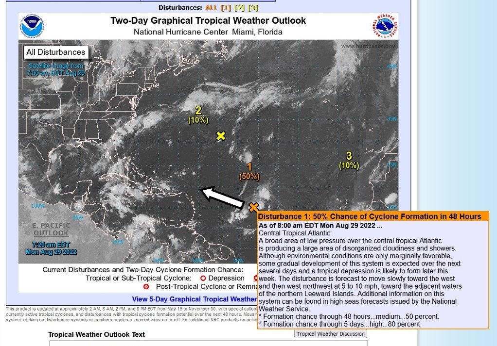
- Moving above us........
|
- By H Hallstrom <hwh888 at gmail.com>
- Date: Mon, 29 Aug 2022 10:21:36 -0400
|
Greetings All,
The approaching tropical disturbance looks to be passing north of the leewards. Looking at satellite images we will be on the "edge" of things and even then it doesn't look to be much of a rainmaker.
The next one, now just moving off Africa, is projected to move further north of leewards as it moves across the Atlantic.
Will keep a watch on events as they develop, especially this time of year.
Harry
|
|
- Update .....
|
- By H Hallstrom <hwh888 at gmail.com>
- Date: Wed, 10 Aug 2022 02:48:41 -0400
|
Greeting All,
Another look at things and there is nothing to report. No threat, most likely no rain.
|
|
- Tropical Atlantic post
|
- By H Hallstrom <hwh888 at gmail.com>
- Date: Sun, 7 Aug 2022 09:15:18 -0400
|
Greetings All,
NHC post this am...........
1. Eastern Tropical Atlantic:
A tropical wave located just off the west coast of Africa is
producing disorganized showers and thunderstorms over the far
eastern tropical Atlantic. Environmental conditions appear generally
conducive for gradual development of this system while it moves
westward to west-northwestward at 15 to 20 mph across the eastern
and central tropical Atlantic, and a tropical depression could form
around the middle part of this week.
Looking at steering winds, if anything developes it will move well north of the Leewards and surrounding area. Will post again if any changes else just continue to watch things. |
|
- July Weather Data for Nevis
|
- By H Hallstrom <hwh888 at gmail.com>
- Date: Mon, 1 Aug 2022 11:25:57 -0400
|
Greetings All,
Attached station weather data for July 2022 for those interested.
Attachment:
07_Jul_2022 NOAA Weather Data.pdf
Description: Adobe PDF document
|
|
- Latest Nevis Weather
|
- By H Hallstrom <hwh888 at gmail.com>
- Date: Sat, 2 Jul 2022 05:38:20 -0400
|
Greetings All,
Last night's rain was a wave that passed well south of Nevis/St.Kitts. It's now moved into the Caribbean Sea moving West and away.
Attachment:
Nevis Weather Jul 2,22.pdf
Description: Adobe PDF document
|
|
- June Weather Data
|
- By H Hallstrom <hwh888 at gmail.com>
- Date: Fri, 1 Jul 2022 08:32:31 -0400
|
Greetings All,
Attached June 2022 Weather Station Data for Nevis,
for those interested.
Attachment:
06_Jun_2022 NOAA Weather Data.pdf
Description: Adobe PDF document
|
|
- May Weather Station Report
|
- By Harry Hallstrom <hwh888 at gmail.com>
- Date: Wed, 1 Jun 2022 21:19:40 -0400
|
Greetings All,
Attached Weather Station Date Report for May 2022 for those interested.
Attachment:
05_May_2022 NOAA Weather Data.pdf
Description: Adobe PDF document
|
|
- Weather Data for Month of April
|
- By Harry Hallstrom <hwh888 at gmail.com>
- Date: Sun, 1 May 2022 10:35:22 -0400
|
Greetings All,
Attached Weather Station data for Nevis April 2022 .
Attachment:
04_Apr_2022 NOAA Weather Data.pdf
Description: Adobe PDF document
|
|