|
|
- - - 2022 Hurricane Season - - -
|
- Ian goes North?
|
- By DushiSolo <marcusdemaaijer at gmail.com>
- Date: Mon, 26 Sep 2022 11:12:43 -0400
|
This is the current position of Ian, it is forecasted to go North, but.... it can still move East or SE, because a cold, high pressure wave is approaching it from the NW, and there is a low and much warmer low pressure East and SE... Eventually it may keep going North, but at this point Curacao does not want a SE movement. not even if it is short lived because this system is Cat 1+ now and can still send compounded waves to the fragile southern coastline of Curacao. Keep your fingers crossed it does not do that... https://ocean.weather.gov/UA/Atl_Tropics.gifLet's start collecting aid for Cuba, and a note to USA border patrol, please scout for economic refugees who may mistakenly get caught up in this bad weather system
Godspeed and Qi to all
-- sincerely,
Marcus A.T. de Maaijer
Willemstad, Curacao (UTC--4)
|
|
- about weather outlook 2022 season
|
- By DushiSolo <marcusdemaaijer at gmail.com>
- Date: Mon, 26 Sep 2022 08:41:30 -0400
|
After the weather system at that time named "9" passed Curacao, it turned back towards Curacao, then moved back in the NW direction. The waves that 9 sent to us arrived yesterday at Westpoint and were mild compared to the waves that Hurricane Omar sent to us in Curacao in 2008. Hurricane Omar too had passed Curacao, then moved in the SE direction towards Curacao for 18 hours, then moved back to the N direction. Several days later the compounded waves hit Curacao and nearly swept Queen Beatrix into Annabay when she was at an event in Punda, and literally destroyed all the fishermen's boats that were onshore or moored at the Southern coastline, and damaged properties on southern coastline areas that had not taken precautionary measures. I and another person at that time did know those waves were heading our way and we issued warnings that helped many. Number 9 now is called Ian and we were lucky that it sent waves in our direction only for the duration of 2 hours. I use NOAA buoy data, which I analyse on spreadsheets and create statistical data tables. I often do not copy and paste sat images/data from other third party sources. Yes, I am an amateur meteorologist and oceanographer. I live on a tiny island in the Caribbean and also knew that climate change will put Curacao smack in the hurricane belt. The thought that we are not in the hurricane belt thus is no longer a fact. Hurricanes are now going places they have never gone before. Even Nova Scotia, Canada found this out when it was hit by ocean waves that pounded the town of Channel-Port Aux Basques on the southern coast of Newfoundland, where entire structures were washed into the sea. Mayor Brian Button said Saturday over social media that people were being evacuated to high ground as winds knocked down power lines, never before in the history of Canada it was hit by a hurricane that came from the Caribbean. The season ends at the end of November. Godspeed and Qi to all. Start preparing if you have not prepared yet. Nobody in or near the Atlantic is safe until mid December.
-- sincerely,
Marcus A.T. de Maaijer
Willemstad, Curacao (UTC--4)
|
|
- rain rain rain
|
- By DushiSolo <marcusdemaaijer at gmail.com>
- Date: Thu, 22 Sep 2022 19:49:01 -0400
|
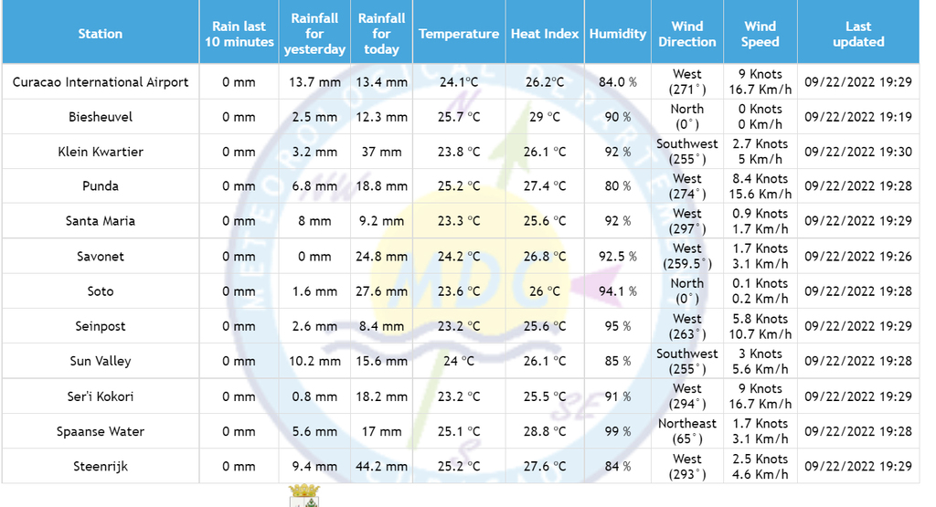 above chart shows how much rain Curacao endured today. The forcast calls for double to tripe amount of rain on Friday between midnight and 6am. We will see....Godspeed and Qi for all.
-- sincerely,
Marcus
Willemstad, Curacao (UTC--4)
|
|
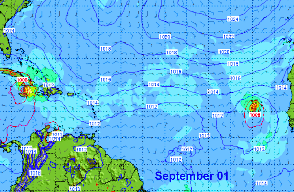
- Sept 1 2022 forecast
|
- By DushiSolo <marcusdemaaijer at gmail.com>
- Date: Tue, 23 Aug 2022 23:43:28 -0400
|
-- sincerely,
Marcus
Willemstad, Curacao (UTC--4)
|
|
- here we go....
|
- By DushiSolo <marcusdemaaijer at gmail.com>
- Date: Tue, 23 Aug 2022 23:29:27 -0400
|
After a rather quiet hurricane season we may see two storm systems pop up at the end of August. One forming north of the ABC islands on Sunday, then possibly heading towards Jamaica or Cuba. A second system jumping off the African coast into the Atlantic at the end of August. I am going to the stores tomorrow on Wednesday to restock my non refrigeration supplies, because September is kicking off with 2 storms on Day 1. Godspeed to everyone.
-- sincerely,
Marcus
Willemstad, Curacao (UTC--4)
|
|
- storm season waking up?
|
- By DushiSolo <marcusdemaaijer at gmail.com>
- Date: Sun, 14 Aug 2022 23:03:52 -0400
|
I hope everyone enjoyed summer break and summer activities during this very mellow storm season. On Tuesday August 23, we may see the first sign of a possible invest developing off the African coast, west of the Cape Verde islands. Is this the one pulling hurricane season out of its slumber? I am actually looking forward to this storm season to be a bust, contradicting the forecast of being above average. -- sincerely,
Marcus
Willemstad, Curacao (UTC--4)
|
|
- weather update June 30 at 5Pm
|
- By DushiSolo <marcusdemaaijer at gmail.com>
- Date: Thu, 30 Jun 2022 17:20:40 -0400
|
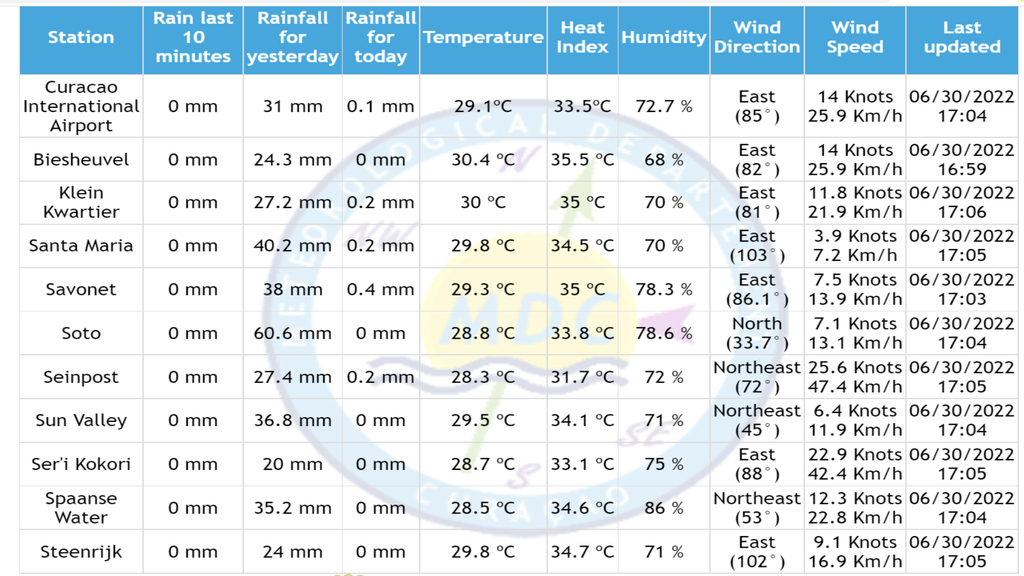
-- |
|
- rain accumulation up to 925pm
|
- By DushiSolo <marcusdemaaijer at gmail.com>
- Date: Wed, 29 Jun 2022 21:48:15 -0400
|
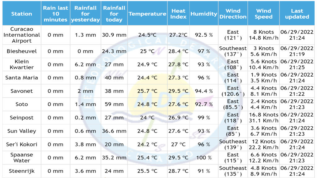
Worst rain accumulation is in the area of Soto with 59mm and Jongbloed, where some houses have been inundated in the latter area. Aside from that Curacao was spared storm winds that passed by due North. No info yet what damage the waves have done on the southern and northern coastline, if any.
The government of Curacao warns that thunderstorms and more rain can follow in the tail of Tropical Storm Two, which can add more rain and flooding such as we experienced during Tomas in 2010,
-- sincerely,
Marcus
Willemstad, Curacao (UTC--4)
Whatsapp: +59996735667
|
|
- Two update
|
- By DushiSolo <marcusdemaaijer at gmail.com>
- Date: Wed, 29 Jun 2022 21:32:48 -0400
|
During the press conference of the government of Curacao at 9pm, the following decisions were made: 1. Curfew will be lifted at 04:00 am on June 30th 2. Schools will remain closed on June 30th 3. The shelters will be closed today at 11pm 4. Curacao now gets code orange 5. Government warns of rain and lightning that may yet come in the tail of this tropical storm. 6. All government personnel are expected to be at work on June 30 and all public departments reopened on June 30.
-- sincerely,
Marcus
Willemstad, Curacao (UTC--4)
Whatsapp: +59996735667
|
|
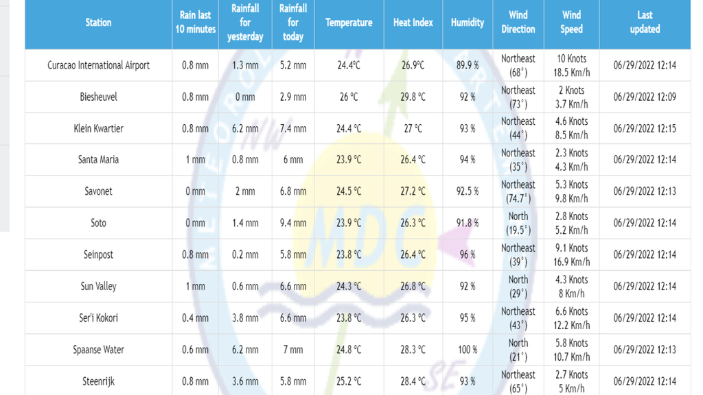
- rain accumulation (so far)
|
- By DushiSolo <marcusdemaaijer at gmail.com>
- Date: Wed, 29 Jun 2022 18:07:25 -0400
|
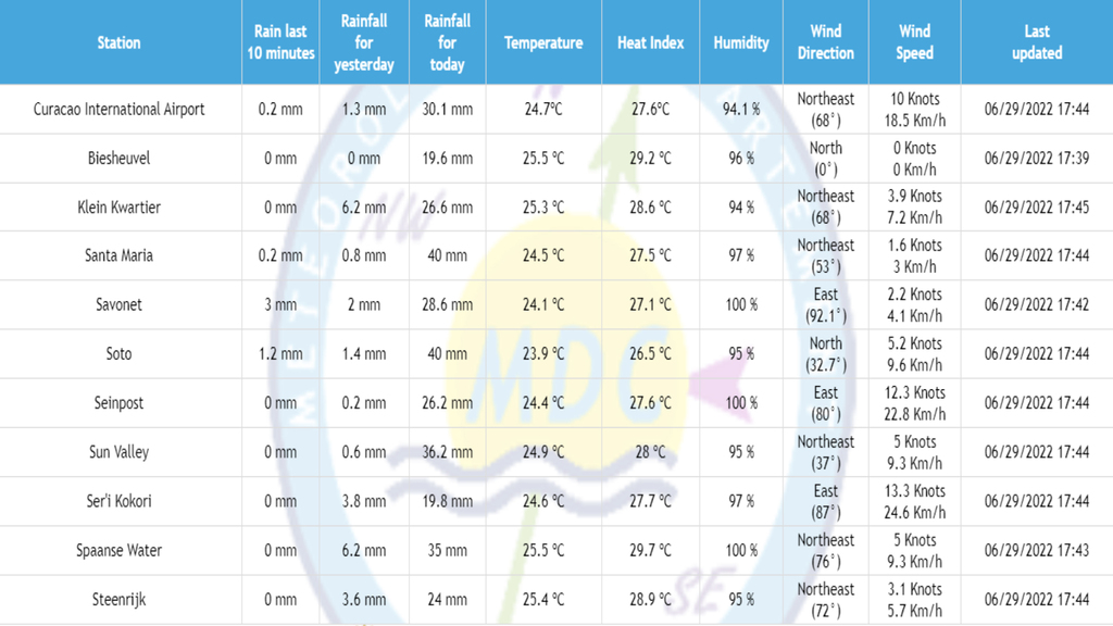
-- sincerely,
Marcus
Willemstad, Curacao (UTC--4)
Whatsapp: +59996735667
|
|
- curfew at 11 am instead of at 4pm
|
- By DushiSolo <marcusdemaaijer at gmail.com>
- Date: Wed, 29 Jun 2022 12:30:18 -0400
|
The government of Curacao announced at a press conference at 915am that the curfew is in effect at 11am instead of 4pm.
-- sincerely,
Marcus
Willemstad, Curacao (UTC--4)
Whatsapp: +59996735667
|
|
- rain accumulation report
|
- By DushiSolo <marcusdemaaijer at gmail.com>
- Date: Wed, 29 Jun 2022 12:27:32 -0400
|
-- sincerely,
Marcus
Willemstad, Curacao (UTC--4)
Whatsapp: +59996735667
|
|
- announcement of Curacao government
|
- By DushiSolo <marcusdemaaijer at gmail.com>
- Date: Tue, 28 Jun 2022 21:29:51 -0400
|
This was announced during the press conference of the Curacao government: at 730pm local time in Willemstad, Curacao. 1. on June 29 curfew from 4 p.m. until further notice, with the exception of vital functions 2. On June 29, all stores except vital signs must close at 3 p.m. This also applies to public authorities. 3. All civil servants can stay home on June 29. This as far as the service allows. Tomorrow and Thursday all public services will be closed 4. All persons residing on the coast areas are advised to move elsewhere inland. The same applies to areas that normally have to deal with flooding. 5. All activities for June 29 and 30 must be cancelled. The government will provide further details on Thursday. 6. On June 29, public transport will run until 4 p.m. Keep this in mind. 7. On June 29, the Emma Pontoon Bridge will be removed from 10:00 a.m. Ferries are available until 4pm to cross between Punda and Otrobanda 8. Use of shelter is the last option if one is not safe at home or elsewhere. There are shelters at Maris Stella sbo, red cross in Barber, among others. Tomorrow the government will indicate all locations for shelters. 9. The Curacao Coastguard advises everyone not to go out to sea and to secure the boats in time by taking them out of the sea and away from the coast areas or placing them in inland waters. 10. As of today, June 28, 97.9 FM (Radio Easy FM) is the emergency radio that the government uses to provide latest information. It is recommended to buy batteries to be able to continue listening to the radio in case power is cut off by the government or due to a failure in the electrical network.
-- sincerely,
Marcus
Willemstad, Curacao (UTC--4)
|
|
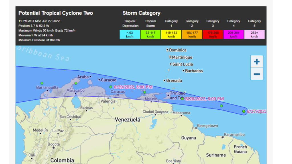
- Two data
|
- By DushiSolo <marcusdemaaijer at gmail.com>
- Date: Tue, 28 Jun 2022 00:20:33 -0400
|
The green dot is where the center of the storm is and possibly will be in the next few days to come. This map shows barometric pressure, wind speeds and direction the storm is moving. What this forecast does not show (yet) is the amount of rain accumulation, potential flooding of inland areas, the coastal damage due to sea waves and storm surge entering southern coastal land areas. Right now it is not a tropical depression, it is a tropical storm, and it has potential to become a cat 1 near us or after passing us in Curacao. Start pruning trees, make a shelter inside your home for pets, remove loose material near buildings, place storm shutters or plywood panels on windows,and if you have a boat, take it out of the water, plus move it inland away from the shore or move it into Spanish Waters, Sint Joris bay, Piscadera bay or Anna Bay. I will update this at 5 - 7 pm on June 28
-- sincerely,Marcus
 |
|
