|
|
- - - 2020 Hurricane Season - - -
|
- Yesterday's eruption spared Barbados
|
- By Jurgen Starck <weather at turtle48.de>
- Date: Sat, 17 Apr 2021 09:05:09 -0400
|
|
Good morning to all,
Barbados got away from yesterday's eruption, the winds blew the
ash plume north-westwards from St. Vincent. However, there was
minimal ashfall in Barbados, a very fine layer of new ash came
down on us.
--
Best regards and stay safe and COVID-19 free! Keep your distance!
Jurgen
Barbados South, near airport (BGI)
|
|
- More damage to come from La Soufrière?
|
- By Jurgen Starck <weather at turtle48.de>
- Date: Sun, 11 Apr 2021 17:03:13 -0400
|
|
Good afternoon to all,
This is an article I just came across, which
is confirming what I have already reported about. It also carries some other
interesting information.
https://www.nationnews.com/2021/04/11/robinson-expects-damage-ashfall/
--
Best regards and stay safe and COVID-19 free! Keep your distance!
Jurgen
Barbados South, near airport (BGI)
|
|
- The day after
|
- By Jurgen Starck <weather at turtle48.de>
- Date: Sun, 11 Apr 2021 12:02:12 -0400
|
|
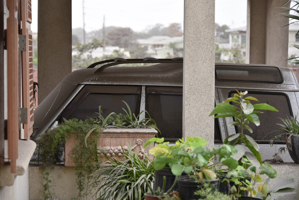
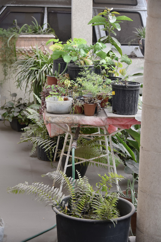
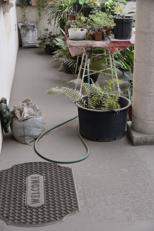
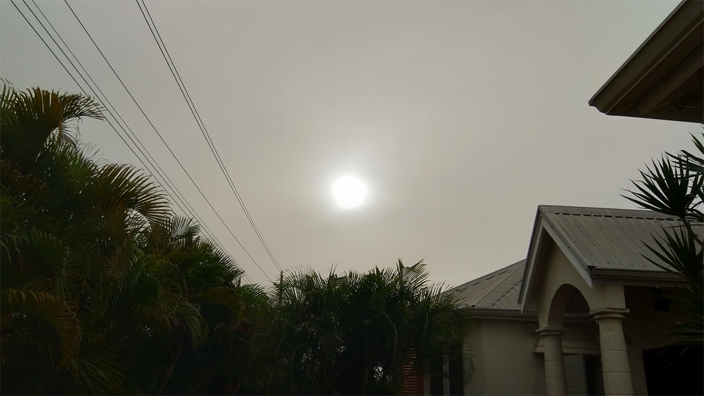
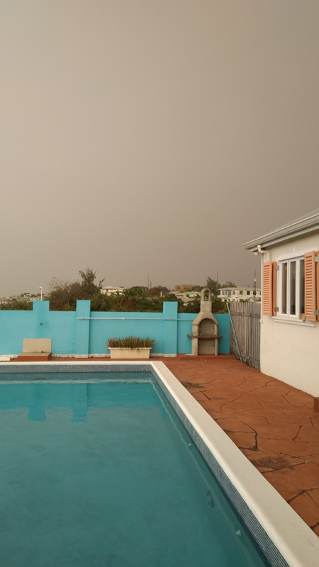
Good morning everyone,
this day began with the most surreal morning view I ever had in
my life. Everything outside looks grey. After a night with
obviously repeated eruptions, about one every two hours, according
to satellite observations. The area looks like it was powdered
with cement. Visibility is still bad and Barbados therefore is
under a small craft warning and ashfall warning.
This is today's newspaper:
https://www.nationnews.com/2021/04/11/new-dome-la-soufriere-blown-away/
Quote NationNews.com: “It seems that a substantial amount of
the 2021 dome has gone, it’s been destroyed. It seems that all
that black 915 [ft] length piece of bits of rock, all that 13
million cubic metres of material has mainly been destroyed in
the activity that we’ve had so far.”
The following article is from yesterday and is showing a part of
the North of Barbados and how dark it was in the afternoon.
https://www.nationnews.com/2021/04/10/volcano-ash-turns-northern-skies-dark/
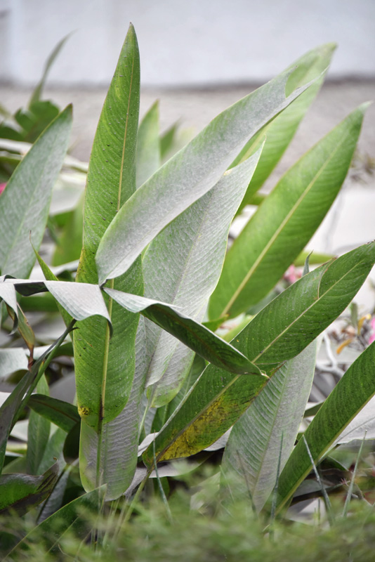
Now my photos are following:
1) Last Night: 21:17 hours. The stripes are from falling ash
particles (due to long exposure they appear as stripes). You could
feel the impact on your skin.
2) This morning: My car covered in dust (original colour is
silver metallic).
3) My wife's plant nursery. I hope the plants will survive that,
otherwise I'll be a dead man after her return from England.
4) The patio floor (original surface: Clay-tone tile2).
5) The heliconias.
6) The driveway in the background (original surface: Clay-tone
bricks).
7) Visibility less than 2 kilometres (the ocean, our usual
horizon is 2 km away but not visible).
The airport is closed since yesterday morning and the closure was
extended to noon today. I suppose we will hear of another
extension soon.
I just heard the latest eruption lasted 1 hr. 20 minutes! I think
right now the plume is arriving here as I am writing.
I will post more news when they come to hand.
--
Best regards and stay safe and COVID-19 free! Keep your distance!
Jurgen
Barbados South, near airport (BGI)

|
|
- The last after the last post
|
- By Jurgen Starck <weather at turtle48.de>
- Date: Sat, 10 Apr 2021 19:50:25 -0400
|
|
Good evening to all,
I am just posting this link which I just have found, not so much
because of the statement of our Minister of Tourism, but more-so
for the statements below, that of our "Chief Weather Man" Dr. Sabu
Best and those following after that. So, scroll down to find it.
https://www.nationnews.com/2021/04/10/live-updates-tourism-ministers-address-april-10-2021/
I thought this might be of interest for some people.
Good night everyone
--
Best regards and stay safe and COVID-19 free! Keep your distance!
Jurgen
Barbados South, near airport (BGI)
|
|
- Daylight conditions changing by the hour
|
- By Jurgen Starck <weather at turtle48.de>
- Date: Sat, 10 Apr 2021 18:27:38 -0400
|
|
It is about 16:30 (4:30 pm) by now. It is
almost dark outside. See first photo, taken around noon.
I can't take any more appropriate photos of the current
situation, because the automatic photo enhancement feature of my
phone is trying to put it back to normal light conditions. I hate
it, when a device wants "to be smart", when it is NOT! Saying the
photos I have don't really reflect the current situation, besides
the first one, too bad!
I also realised, that my "internal clock" is focussed on
daylight. On normal days I could always tell you how late it
approximately is, meaning time of day. Today that clock was
completely screwed up. I went to the kitchen to prepare dinner
around 16:30 hours (4:30 pm). Usually, I never do that before 6 or
7 pm!
At about 15:30 (3:30 pm) the photo cell controlled street light
came on. Second photo. Usually it comes on around sunset (6 pm or
so).
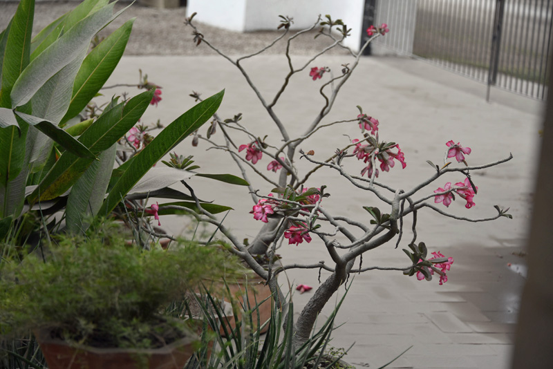
In the afternoon 17:30 (5:30 pm) the ash downfall became visible
to the naked eye on my plants. Third photo.
That was my last post for the day.
--
Best regards and stay safe and COVID-19 free! Keep your distance!
Jurgen
Barbados South, near airport (BGI)


|
|
- Ash fall minimal, so far
|
- By Jurgen Starck <weather at turtle48.de>
- Date: Sat, 10 Apr 2021 12:37:44 -0400
|
|
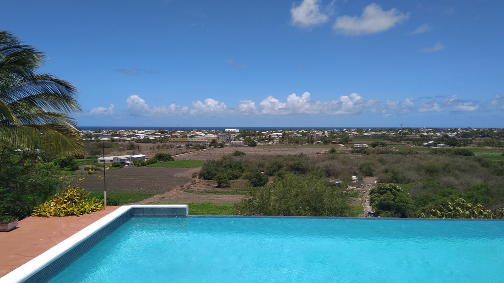
I just made the "finger test" on the ground.
There is minimal ash fall,
invisible to the naked eye and very fine, in Barbados. Only on
the finger it is visible.
I also added two photos of my current view
and my view on a clear day.
--
Best regards and stay safe and COVID-19 free! Keep your distance!
Jurgen
Barbados South, near airport (BGI)

|
|
- Brown Sky!
|
- By Jurgen Starck <weather at turtle48.de>
- Date: Sat, 10 Apr 2021 09:09:40 -0400
|
|
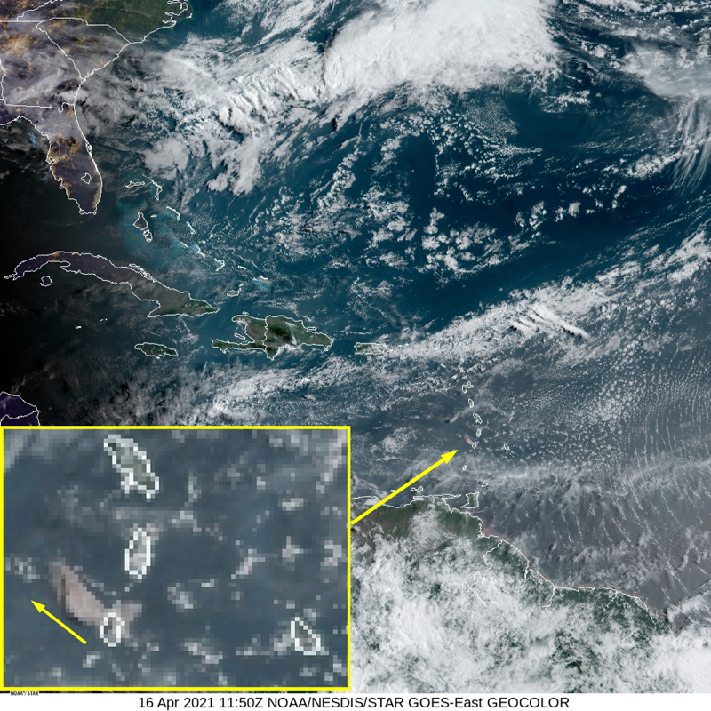
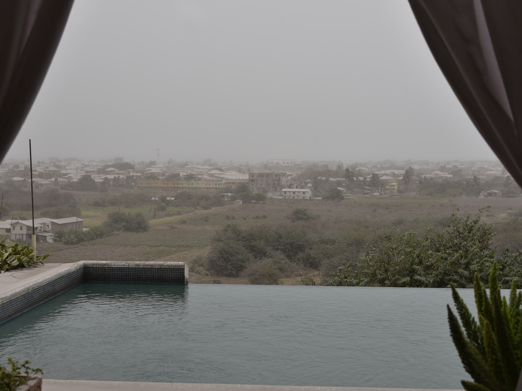
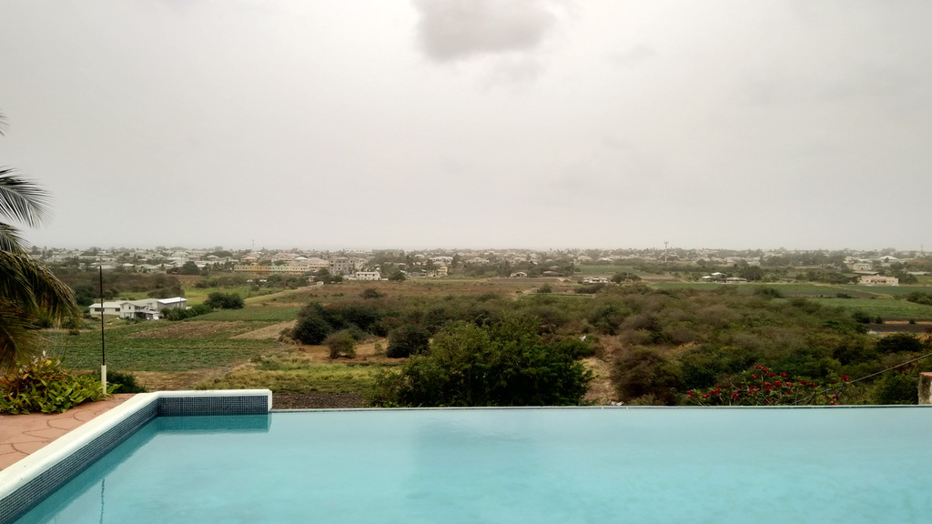
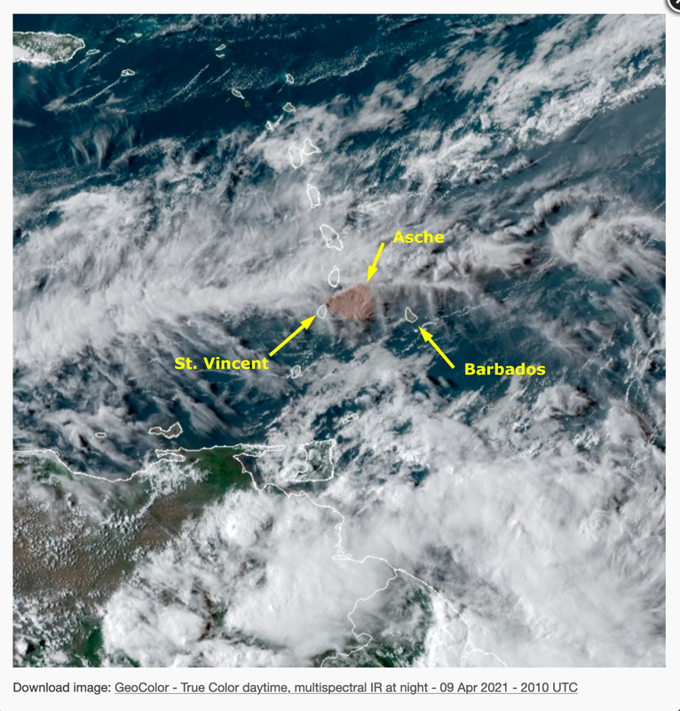
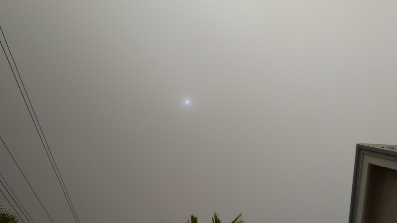
Good morning to all,
Ashes from La Soufrière passing over
Barbados. The ash plume from La Soufrière volcano gets blown
right across Barbados, see attached images. According to the
NOAA GOES Satellite images from yesterday the plume should have
arrived over Barbados around sunset. However, daylight
disappeared and there was no ash visible at that time. This
morning it's a very different story. The sun is having trouble
to get through the ash plume. Apart of that we also have a very
thick layer of Saharan Dust.
As I am writing all of a sudden it became pretty
dark! The ash plume is getting much thicker and indeed it looks brown. So
far, there was no downfall of ash.
A satellite video showing the moment when
the volcano erupted can be seen using the link below, quite
impressive.
https://twitter.com/uwiseismic?fbclid=IwAR2ej6iCAO_kPHcTpgOBpnEy9RfCpP7LJ0QOLOpMtFBqOFufAx1Qwe-iCEM
That's it for now.
--
Best regards and stay safe and COVID-19 free! Keep your distance!
Jurgen
Barbados South, near airport (BGI)
|
|
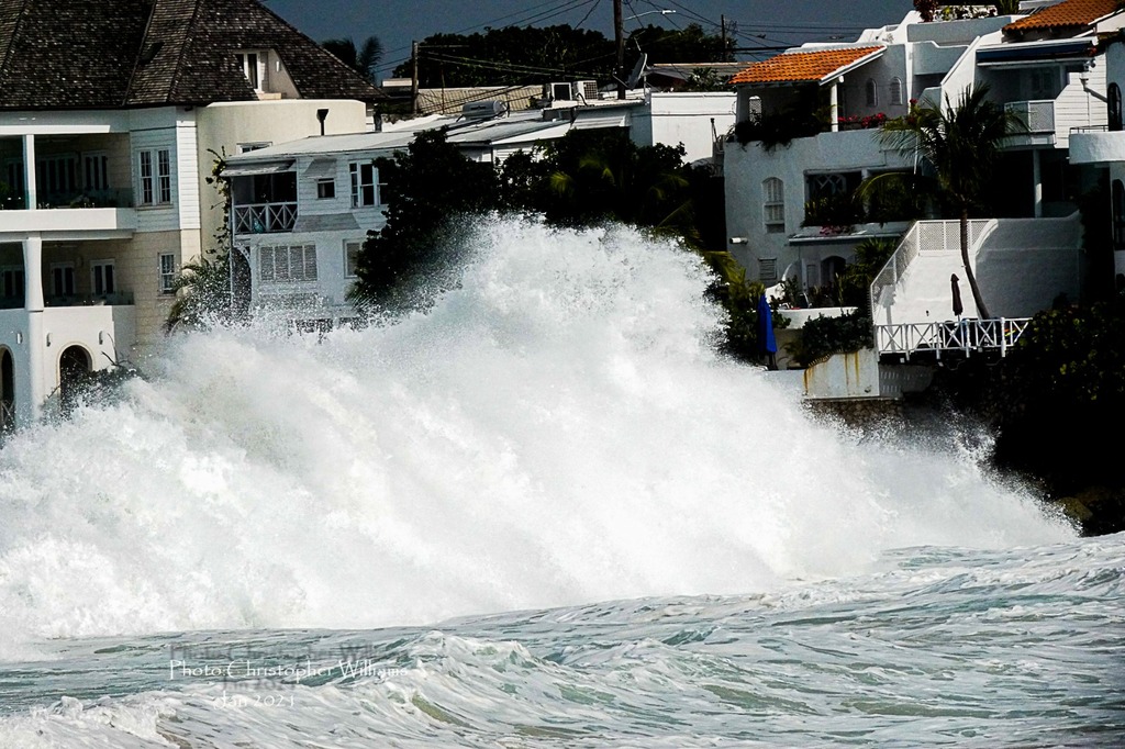
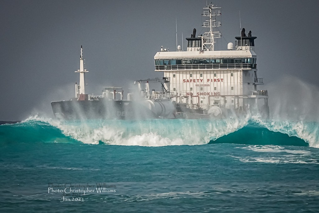
- High Surf
|
- By Jurgen Starck <weather at turtle48.de>
- Date: Wed, 3 Feb 2021 18:43:12 -0400
|
|
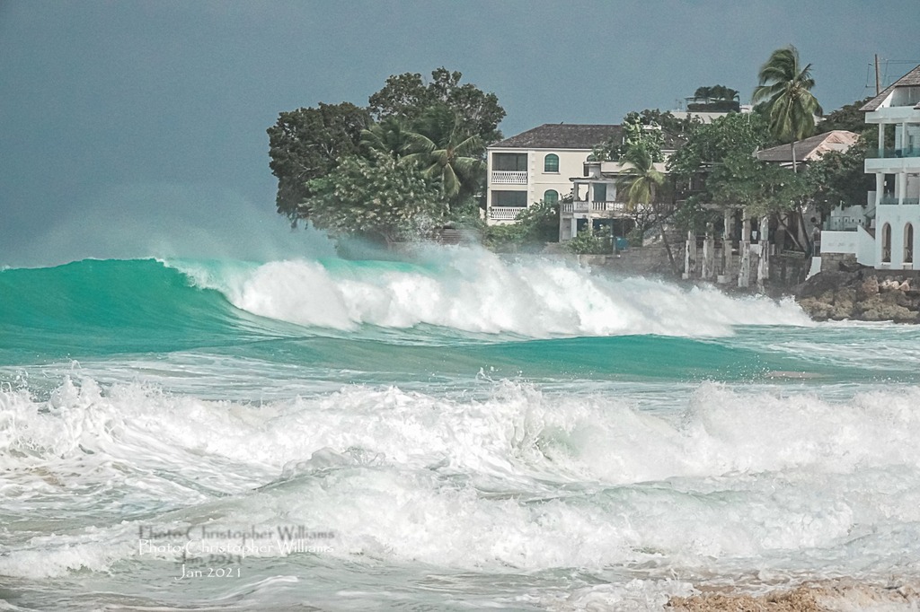
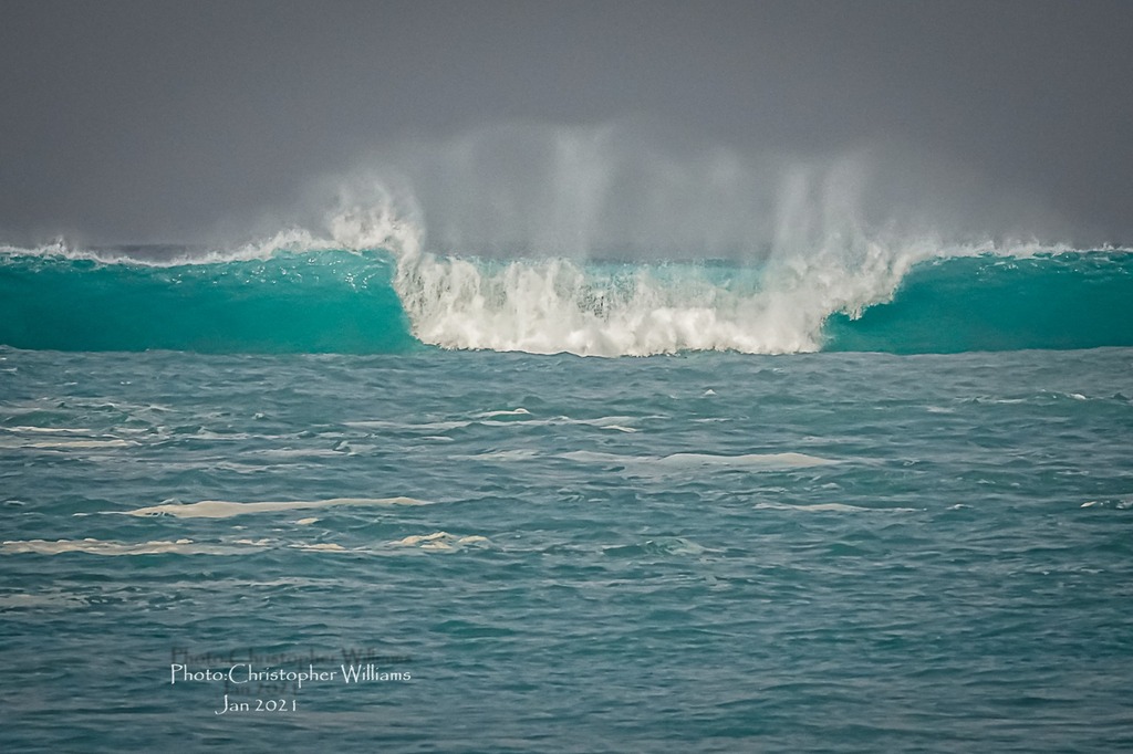
Good evening everyone,
I am sorry for posting late I am just in the process of getting a
new computer going. Since months I was without one.
During the past few days Barbados has been under a "High Surf and
Small Craft Warning", due to swells up to 3.5 meters (12') along
with winds of about 35km/h with higher gusts. In the mean time
this Warning has been downgraded to an Advisory. Because those
swells were very impressive, I thought I will post them here. It's
something you really don't see every day. In particular not on
Barbados' West Coast, which usually is very calm.
Sadly, one British tourist did not adhere to warnings from locals
and ventured into the sea. He got hit by one of those big rollers
and did not resurface. His body was found a day or two later on
the same coast a few miles South of where he was hit.
So, here it comes. These photos have not been taken by myself (I
wished they were...), they are from the internet and I don't know
whom to give credit.
--
Best regards and stay safe and COVID-19 free! Keep your distance!
Jurgen
Barbados South, near airport (BGI)


|
|
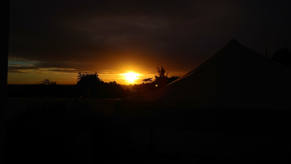
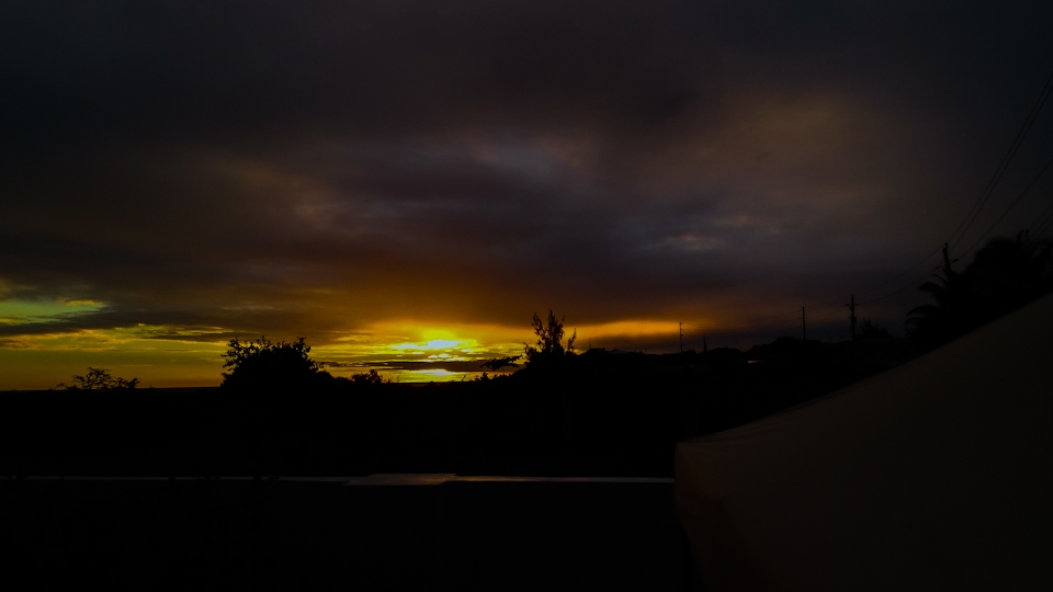
- Isabel's post from St. Croix really touched me!
|
- By Jurgen Starck <juergen at turtle48.de>
- Date: Fri, 04 Dec 2020 00:43:20 -0400
|
|
Isabel's post of 2020-11-30 from St. Croix really got me. Everyone interested can find it on the "Special Hurricane Correspondents" page of St. Croix. I am not going into details here because it's not my place do.
But, for the sake of the "tradition" she has started I have asked her, if I may use her photo title "Last photo(s) of the day" as well, and I just got her positive reply. Thanks, Isabel!
As Gert has mentioned, Isabel is one of us correspondents who has posted every day! No matter if something has happened or not. But her "last photo(s) of the day" and other photos have always been phenomenal!
Since she now has to care about here private life, I want to pick up on the her photo scheme, using the same title with her permission. Probably I am not doing that every day. But when the sunset is beautiful or dramatic, and I have a chance to shoot it, I will certainly try my best.
Starting tonight right here and now!
|
|
- We had some too
|
- By Peter Allen <stilettocruises at yahoo.com>
- Date: Mon, 9 Nov 2020 10:50:31 +0000 (UTC)
|
We had some too Sunday afternoon,one rain band for an hour or so.I was out on a
cruise and you could'nt see 50 ft in front of the boat what you would call
white rain.No flooding that i'm aware of as it did not last long enough but it
shure was wet,the potato salad was floating out of the salad bowl lol.
|
|
- Rain
|
- By Peter Allen <stilettocruises at yahoo.com>
- Date: Thu, 29 Oct 2020 11:23:31 +0000 (UTC)
|
If the cloud i see on radar this morning materializes with more rain we will
have to rename the island "All AWASH"
|
|
- Rain
|
- By Peter Allen <stilettocruises at yahoo.com>
- Date: Tue, 29 Sep 2020 11:45:13 +0000 (UTC)
|
Late yesterday afternoon into early night we had some good rain in Barbados
including an electric light show.
|
|
- Different Planet
|
- By Peter Allen <stilettocruises at yahoo.com>
- Date: Wed, 23 Sep 2020 13:00:08 +0000 (UTC)
|
Looking at the NHC this morning feels like being on the wrong planet,an empty
Atlantic Ocean phew.
|
|
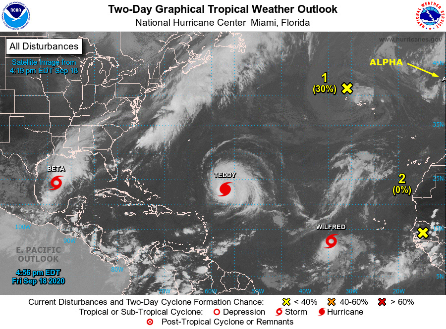
- North Swells
|
- By Peter Allen <stilettocruises at yahoo.com>
- Date: Sat, 19 Sep 2020 13:41:14 +0000 (UTC)
|
I'm seeing a forecast for a surging north swell turning into a rather large one
Thursday/Friday from the North so the whole week it looks like the west coast
of the islands will have surf.What gets me  is where is it coming from,Teddy is
moving NW and can't be generating a swell behind it,who knows fill me in.I also
see a spurt of (SAL) coming down from North Africa,hopefully this will inhibit
every cloud coming out of West Africa to be searching for a name.
|
|
- What a crazy day!
|
- By Jurgen Starck <weather at turtle48.de>
- Date: Fri, 18 Sep 2020 18:50:45 -0400
|
|
Good evening to all,
Three new storms in one day and already TWO Greek names taken!
Today must be another record breaking day! I got to be careful,
this day isn't over yet. ;-)
The first Greek name taken by a storm on Portugal's coast?!
Awesome. =-O
Speaking of "Greek names". What is next when they run out? Does
the NHC have a plan "C" or may they go into collective
self-isolation? :-\
To make things worse in terms of "crazy", there was also a
"Medicane" named IANOS today! =-O
See here
https://edition.cnn.com/2020/09/17/weather/medicane-ianos-mediterranean-hurricane-greece/index.html.
I heard in some news a passenger ship has capsized in it.
Feel free to comment/reply.
May you all have a good night.
--
Best regards and stay safe and COVID-19 free! Keep your distance
and wear proper masks!
Jurgen
Barbados South, near airport (BGI)
|
|
- 98l
|
- By Peter Allen <stilettocruises at yahoo.com>
- Date: Thu, 17 Sep 2020 11:42:57 +0000 (UTC)
|
Not that it means anything but the models have moved the track of 98L north
lets all hope it bears fruit,the present intensity forecast is to TS
strength,With Teddy at his closest point after lunch today we can look forward
to another no wind ripping hot day in the windward islands.I expect to see
convective cloud from the heat on island which can produce flooding,with top
gust forecast to be 6 Knots and direction all over who knows where the cloud
will set up and flood out while sunbathers on the opposite side bask and
complain how hot and it is.
|
|
- I cringe looking at the NHC home page with storms everywhere
|
- By Peter Allen <stilettocruises at yahoo.com>
- Date: Tue, 15 Sep 2020 17:03:11 +0000 (UTC)
|
Teddy is now 14N latitude and appears to have started the jog northward thank
goodness for us all.It is a belief that when hurricanes approach the island
chain once north of your latitude they are gone bye bye,a sobering reminder
would be the last major hurricane to hit Barbados (Janet 1955) she came from NE
to SW after us it hit Grenada so not always true.Next in line is 98L at 9N
looking to fill the void south where these other storms have not, humm eyes
peeled to the east.
|
|
- Hurricane Teddy to be.
|
- By Peter Allen <stilettocruises at yahoo.com>
- Date: Mon, 14 Sep 2020 10:33:05 +0000 (UTC)
|
Thank goodness the NHC track takes this one north of the islands,Teddy has
nothing in his way,don't take your eye off this thing until you see 19.5
latitude.Next in line is the wave that emerged off the African coast with a
projected westward track.Several of us boat owners can't run south,Trinidad is
locked down and Grenada is probably chock a block with boats.Weather in
Barbados has been no wind and ripping HOT!
|
|
- Flash flood warning in effect for Barbados!
|
- By Jurgen Starck <weather at turtle48.de>
- Date: Sat, 12 Sep 2020 16:58:35 -0400
|
|
Good afternoon everyone all,
Barbados is under flash flood warning again, as of 3:20 pm. I am
seeing dark clouds from my location and thunder coming from the
centre of the island. There has practically been no wind today and
it is awfully humid. After looking at some websites (links below),
it appears that TS PAULETTE is sucking in the trade winds coming
fro the East and steeling us the breeze. But not just that, it
also appears that it is sucking in the moisture from south-east of
Barbados. The BWS weather cam (link below) is looking NW and the
clouds are coming from the left, hence a southerly direction.
These Thunderstorms came from the South, not from the East (at
least not directly).
GOES Tropical Atlantic animation:
https://www.star.nesdis.noaa.gov/GOES/sector_band.php?sat=G16§or=taw&band=GEOCOLOR&length=96
BWS weather cam looking NW from the airport:
https://www.barbadosweather.org/VideoStore/WxCam_displayer.php?Instrument=Camera&Period=20%20min&Title=Cam%204%20NW
--
Best regards and stay safe and COVID-19 free! Keep your distance
and wear proper masks!
Jurgen
Barbados South, near airport (BGI)
|
|
- Torrential Rain
|
- By Jurgen Starck <weather at turtle48.de>
- Date: Thu, 3 Sep 2020 17:49:38 -0400
|
|
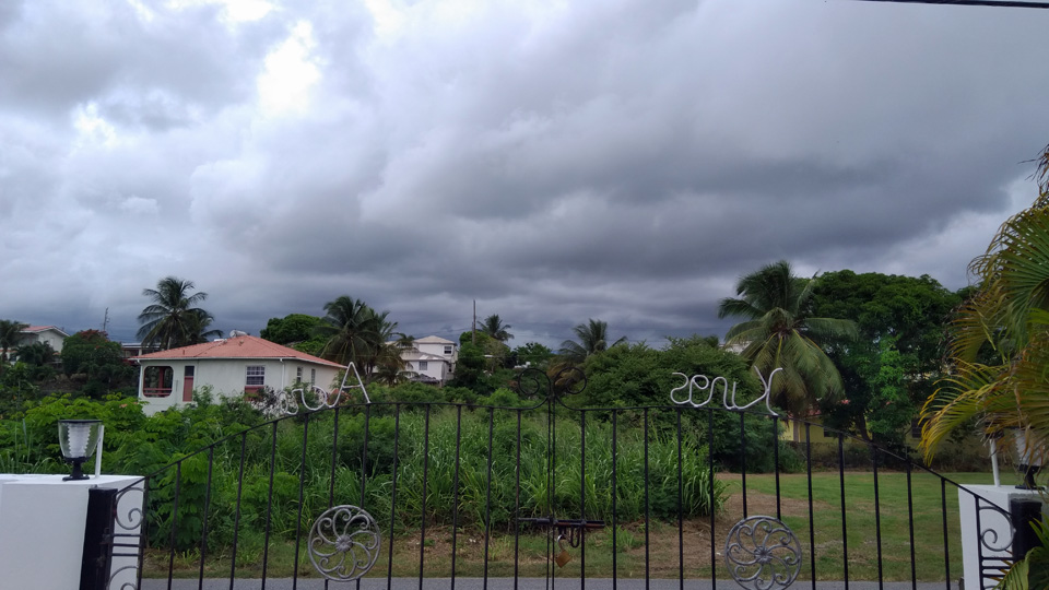
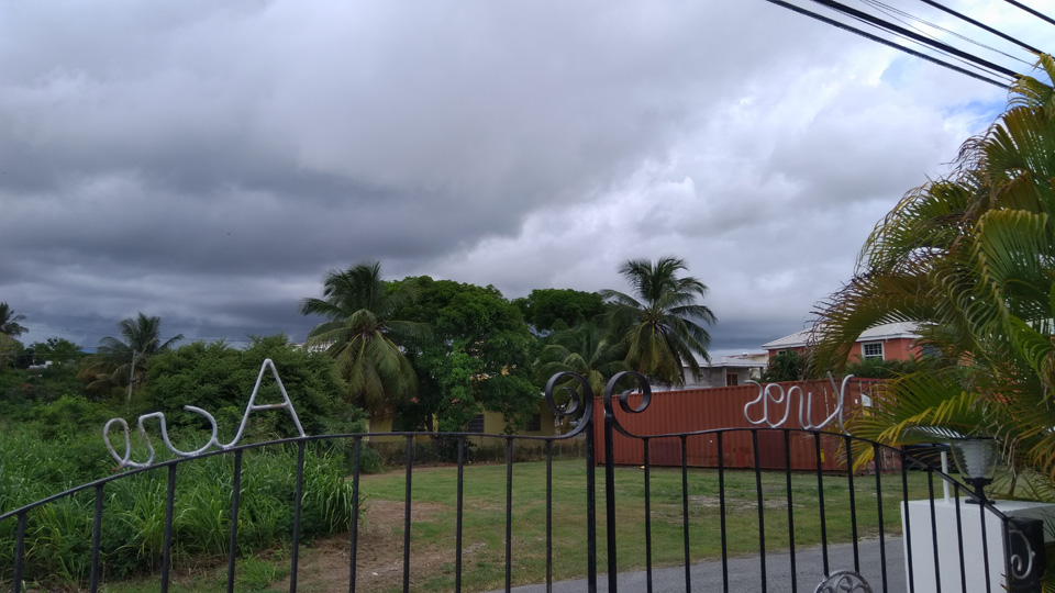
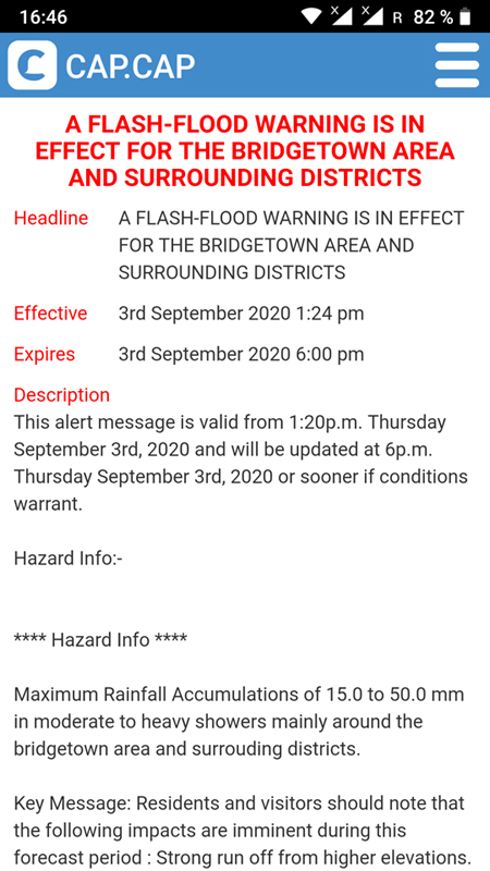
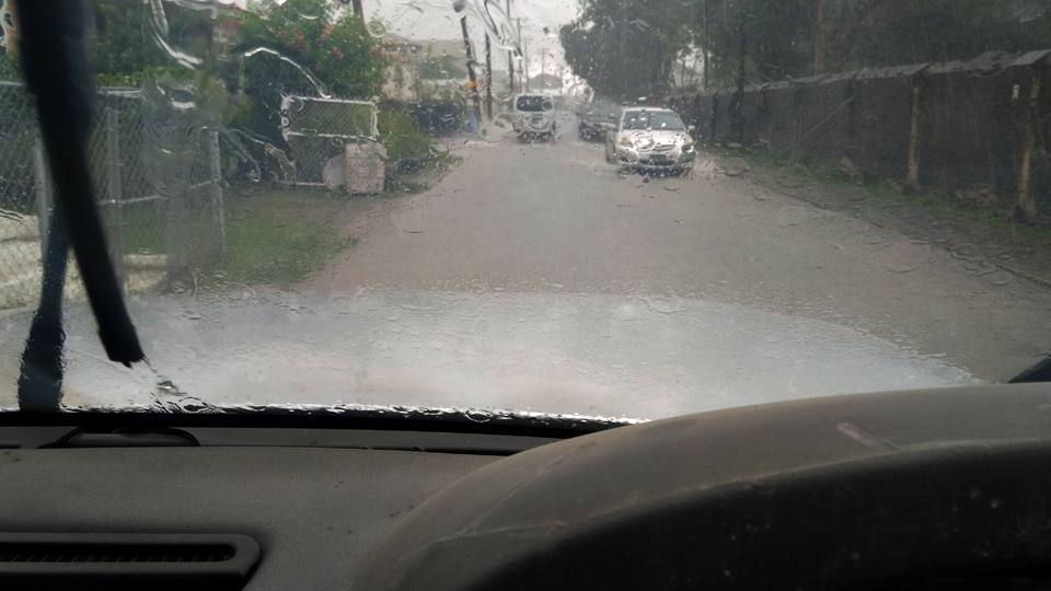
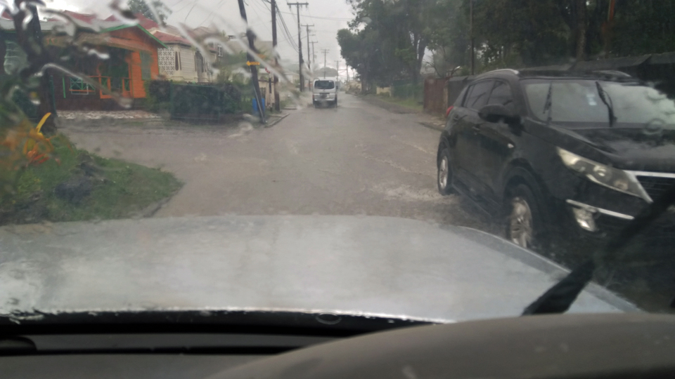
Good afternoon to all,
A low pressure system was passing through around midday.
According to GEOCOLOR satellite image slide show and personal
observation of changing wind directions, apparently it had some
sort of a light rotation attached to it. Also lots of torrential
rain in it's "carry on luggage".
A flash flood warning from the Barbados Weather Service issued
via the CAP.CAP App at 13:21 hrs came about an hour too late to be
a useful warning (image 1, partial warning). Hence, I was driving
right through it, felt like having a riverboat cruise ;-) ! (image
2 and 3)
--
Best regards and stay safe and COVID-19 free! Keep your distance
and wear proper masks!
Jurgen
Barbados South, near airport (BGI)
|
|
- Invest 97L
|
- By Jurgen Starck <weather at turtle48.de>
- Date: Mon, 17 Aug 2020 22:24:55 -0400
|
|
Good night to all,
Down here in the South of Barbados we had a number of showers
over the day, from just drizzle all the way up the scale to
strong. On and off not continuously. As I type a light rain
started again after we had a pause for a few hours, which now
getting more moderate. Glad that the much needed water didn't come
down in one single water inferno. However, Barbados is still under
flash flood warning.
Looking out now for 98L. Let's see what cards that one is holding
in his hands.
--
Best regards and stay safe and COVID-19 free! Keep your distance!
Jurgen
Barbados South, near airport (BGI)
|
|
- Invest 97L
|
- By Peter Allen <stilettocruises at yahoo.com>
- Date: Mon, 17 Aug 2020 17:30:10 +0000 (UTC)
|
It's now 1.30 pm and we are still under yellow orange and red clouds per the
satellite pic but no rain so far to speak of .
|
|
- Tropical wave
|
- By Peter Allen <stilettocruises at yahoo.com>
- Date: Mon, 17 Aug 2020 14:00:01 +0000 (UTC)
|
Barbados is under some good cloud mass via satellite pics, however very little
rain here so far this morning winds are NE 10-12K.The dog is at my feet under
the desk and has not bolted for the bathroom up behind the toilet bowl,this
means the barometric pressure is still reasonably high.
|
|
- Now it's August
|
- By Peter Allen <stilettocruises at yahoo.com>
- Date: Fri, 7 Aug 2020 12:17:39 +0000 (UTC)
|
Here we go again,good rain in Barbados last nite though,my weatherman the dog
spent the better part of it in the bathroom awating the thunder,i think she has
an onboard barometer.
https://www.nhc.noaa.gov/gtwo.php?basin=atlc&fdays=5
|
|
- NINE ???
|
- By Jurgen Starck <weather at turtle48.de>
- Date: Wed, 29 Jul 2020 00:17:10 -0400
|
|
Good evening to all,
I am getting the feeling that the NHC is that one not getting
right either, like GONZALO! The latter was "too small" this one is
"too large and elongated". What will be the next excuse? The
latest advisory did not even referred to the results of the
Hurricane Hunter they claimed earlier to have sent into it. How
can we possibly trust the NHC any longer?
The Barbados Weather Service
(BWS) is since recent times having their own access to
satellite and radar images and analysis software. This allowed
them to call off storm conditions for GONZALO on Saturday before
it would have possibly hit us. The same thing now with NINE. This
one have never been a threat to our island according to the our
BWS.
BTW: We have an early warning system in place for all sorts of
emergencies affecting us like high seas, storms, earthquakes,
volcanoes and whatsoever. It's called CAP. What I don't know is
how far the reach goes out, but the news are focussed on Barbados
only. Google CAP or CAP.CAP and find out if your country/island
has coverage.
For a round-up of this day the rain was on and off the whole day.
Being strong and short (see video attached) to long and just a
drisle. Right now nothing, nada, niente. Saying no wind no rain.
And no, never any wind even near storm-force. Some gusty breezes,
yes. But all in the green alarm level.
The worst we had today was this, enjoy the lame video.
However, I am truly crossing my fingers for the Leeward Islands!
What an ironic name when you are in the cross hairs! A very
special "Good Luck" to all you up there!
--
Best regards and stay safe and COVID-19 free! Keep your distance!
Jurgen
Barbados South, near airport (BGI)
Attachment:
20200728_141118_PC_NINE.mp4
Description: video/mp4
|
|
- 92L
|
- By Jurgen Starck <weather at turtle48.de>
- Date: Tue, 28 Jul 2020 13:30:40 -0400
|
|
Good afternoon to all,
the first rain of 92L just began to fall and heavy but short! And
this is obviously just the western edge of it. Thunder rolling in
the distance as I am typing.
--
Best regards and stay safe and COVID-19 free! Keep your distance!
Jurgen
Barbados South, near airport (BGI)

|
|
- Tropical storm Gonzalo
|
- By Peter Allen <stilettocruises at yahoo.com>
- Date: Sat, 25 Jul 2020 10:06:16 +0000 (UTC)
|
Tropical storm hits Trinidad 25th July 2020 weak as it maybe,well well just
when i thought i'd seen it all for 2020.
|
|
- TS GONZALO - no longer a threat to Barbados
|
- By Jurgen Starck <weather at turtle48.de>
- Date: Fri, 24 Jul 2020 20:20:00 -0400
|
|
Hi to all,
As of 8pm tonight the storm warning for Barbados has been lifted!
Let's see what the current Disturbance 1 is bringing us. The
5-day-chance is at 50%!
--
Best regards and stay safe and COVID-19 free! Keep your distance!
Jurgen
Barbados South, near airport (BGI)
|
|
- What is going on?
|
- By Jurgen Starck <weather at turtle48.de>
- Date: Thu, 23 Jul 2020 11:54:21 -0400
|
|
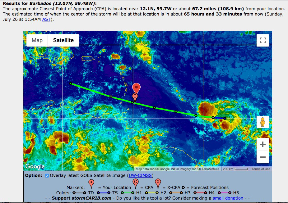
Hi to all,
Have a look at stormcarib.com (closest
point), it looks like GONZALO has split in TWO (or THREE?)!!! I
have never seen anything like that! Even the NHC has no clue
(excerpt from advisory #8):
...GONZALO FACES AN UNCERTAIN FUTURE...
...BUT EXPECTED TO BEGIN AFFECTING PORTIONS OF THE WINDWARD ISLANDS
ON SATURDAY...
I haver never read anything like that. I think that is the right
moment to send a Hurricane Hunter down here!!!
This is getting more interesting by the minute!
--
Best regards and stay safe and COVID-19 free! Keep your distance!
Jurgen
Barbados South, near airport (BGI)
|
|
- Saharan Dust Haze, Forecast
|
- By Jurgen Starck <weather at turtle48.de>
- Date: Mon, 22 Jun 2020 14:53:33 -0400
|
|
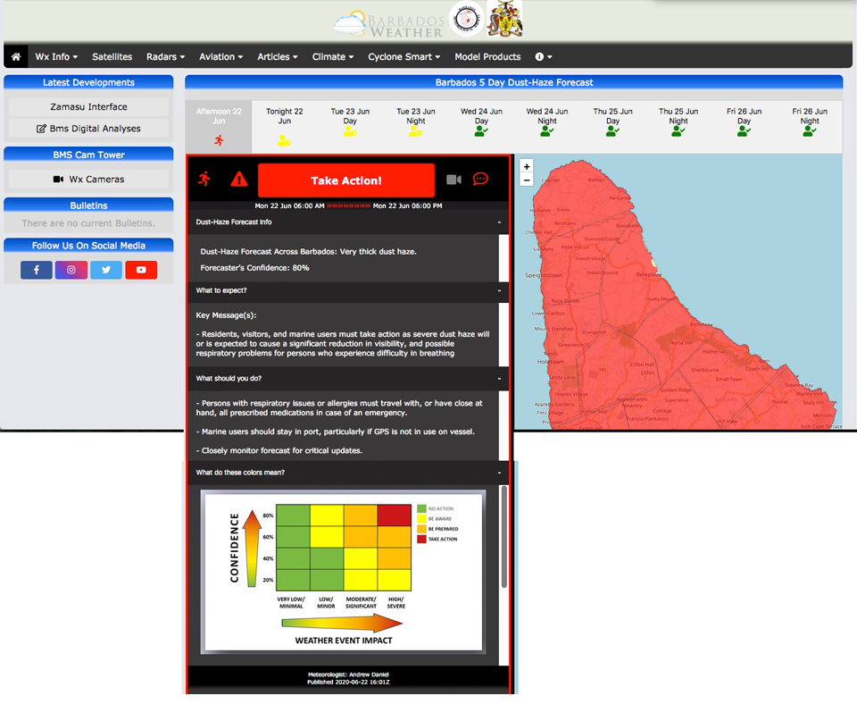
Hi to all,
this is an addendum to my previous post. I have compiled an
all-in-one graphic from the BWS website
[https://www.barbadosweather.org/dustHazeBarResp.php] which
summarizes all the tabs in the red framed area. See attachment.
The forecast (the row of icons with dates and times) below the
blue headline shows that the "red-alert-level" will end by this
evening. It will be lowered to "yellow" from this evening until
tomorrow evening an by Wednesday it should be over.
NOTE: This is valid for Barbados! The timeline may vary,
depending on which island you are!
I thought this might be of interest for many of you, if not all.
--
Best regards and stay safe and COVID-19 free! Keep your distance!
Jurgen
Barbados South, near airport (BGI)
|
|
- Saharan Dust Haze
|
- By Jurgen Starck <weather at turtle48.de>
- Date: Mon, 22 Jun 2020 11:34:26 -0400
|
|
Hi to all,
as some correspondents from other islands have reported the
Saharan Dust Layer is here an can be easily seen. In Barbados it's
no different. The following photo shows the haze from my terrace
looking South. The horizon can hardly be seen! This photo has been
taken Jun 21 10:20 am.
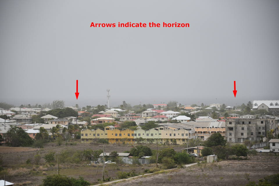
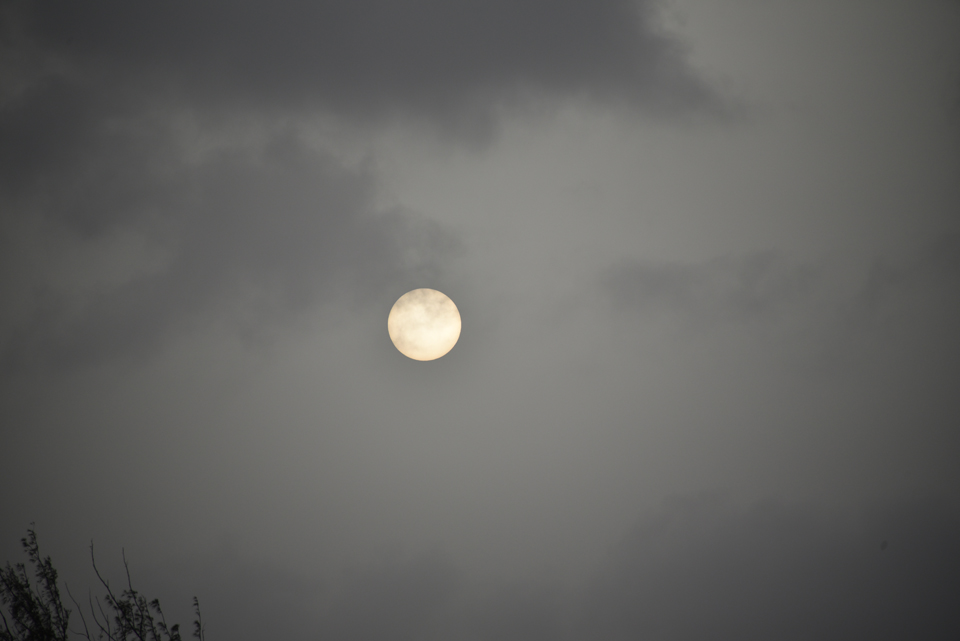
The following photo is yesterdays sunset. I have never seen such
a sunset. Not a bit of the usual orange tint, just the yellowish
colour of the dust haze.
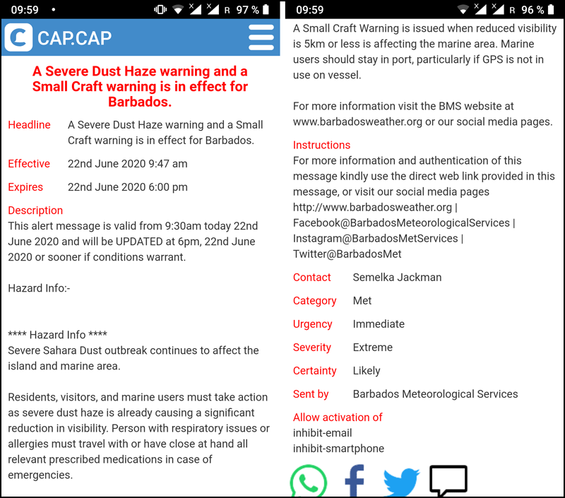
Over the past few days the Barbados Met service has issued a
number of warnings over the media and the emergency warning system
"CAP". The latest warning came in just at 9:59 am this morning.
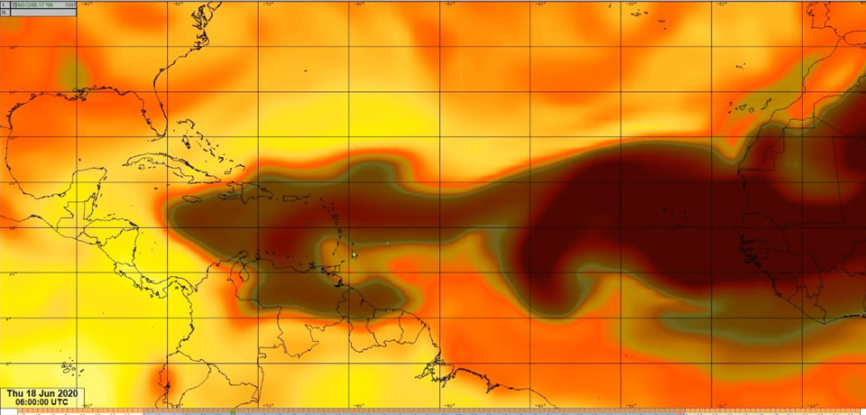
I also found this graphic on the Barbados Met service website
[https://barbadosweather.org/]. It is from 4 days ago when the
dust haze began to intensify. It's a screenshot of animation.
Unfortunately, this animation has been taken off the website.
That's it for today.
Be prepared!
--
Best regards and stay safe and COVID-19 free! Keep your distance!
Jurgen
Barbados South, near airport (BGI)
|
|
- Disturbance 1, a.k.a, "The X"
|
- By Jurgen Starck <weather at turtle48.de>
- Date: Thu, 11 Jun 2020 22:29:34 -0400
|
|
Hi to all,
what this morning was "Disturbance 1" on NHC's website has
disappeared from NHC. A while ago I was about to write the same
thing as Peter. Then the 20 sec rain he mentioned came down. After
a while more came. It seems to have stopped about 45 min. ago or
so. Was a good garden soaking, but way not enough for our
aquifers. Some of their water levels are dangerously low!
I added a few pictures.
--
Best regards and stay safe and COVID-19 free! Keep your distance!
Jurgen
Barbados South, near airport (BGI)


|
|
- The X
|
- By Peter Allen <stilettocruises at yahoo.com>
- Date: Fri, 12 Jun 2020 00:51:12 +0000 (UTC)
|
So far not a puff not a drop not a rumble,i have a small old dog who is semi
blind,this animal (Tinks)can out wit the NHC,she don"t like to get wet bathe or
clip nails but she 's outside running down the neighbor's cat,i think smell and
ear have improved along with some bat like qualities.The one before her was
Rabies who came home with me from Union,she had lunch with the minister of
health,that one is another story.
|
|
- Bad Weather
|
- By Peter Allen <stilettocruises at yahoo.com>
- Date: Fri, 12 Jun 2020 01:03:08 +0000 (UTC)
|
No sooner than i press click the dog fly inside,big heavy rain for 20 sec maybe
this is the start of water for the plants.
|
|
- Sun's highest altitudes dates and times.
|
- By Jurgen Starck <weather at turtle48.de>
- Date: Sun, 26 Apr 2020 18:48:08 -0400
|
|
Good evening to all,
in addition to my previous posting here is the list I mentioned.
I hope this works, because it contains some HTML-code.
The Sun's highest altitudes for 2020.
Past events (as of date of posting):
Grenada 20th April at 12:05
Barbados 23/24th April at 11:56
Events to come (as of date of posting):
St Lucia 26th/27th April at 12:01
Martinique 28th/29th April at 12:01
Dominica 1st May at 12:02
Guadeloupe 4th May 12:03
Montserrat 6th May 12:05
Antigua 7th May 12:04
St Kitts 8th May 12:07
Jamaica (Kingston) 10th May 12:04
St Maarten 11th May at 12:09
Anguilla May 11th 12:09
Puerto Rico May 12th 12:21
Dominican Republic (Santo Domingo) 12th May 12:36
All times are in [AST] around noon. List ordered by date.
Credits: Chris Bolt, Grenada / heavens-above.com.
--
Best regards and stay safe and COVID-19 free! Keep your distance!
Jurgen
Barbados South, near airport (BGI)
|
|
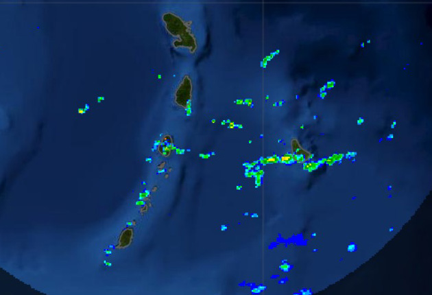
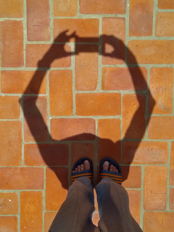
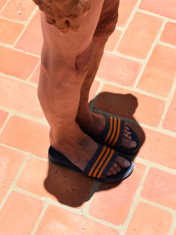
- Not about storm, but also starts with an "s" as in sun.
|
- By Jurgen Starck <weather at turtle48.de>
- Date: Fri, 24 Apr 2020 21:17:00 -0400
|
|
Good evening to all,
today at 11:56am the sun was passing over Barbados at it's
highest point for the year and straight up above our heads. A
fellow "special hurricane correspondent" from Grenada, Chris Bolt
(a.k.a. "Hogan"), pointed me to this event, as it was on past Mon,
20 Apr 2020 06:55:01 [AST] for Grenada. Have a look at the Grenada
page for that matter. When I read about the Monday event it was
already too late for me to take a photo that day, so I tried it a
day later. I took a quick shot with my cell phone. See first
attachment. I have sent it to Hogan, who was thrilled about it,
and then he supplied me with the exact time for Barbados. Thanks a
lot, Hogan!
So, today was the day and I had some time to prepare and set up
the cameras. While waiting for 11:56am to come I took a shot of
the scene with my remote controlled cell phone. See attachment #2.
Shortly after the moment was here and, "cheese" and click! See
attachment #3!
If you kindly neglect the shadow of my arms and shoulders, you
may find that there is hardly any other shadow left on the ground.
Note the timestamp in the file name (if visible). The photo was
taken at 2020-04-24 11:56:21 [AST], sharp on the minute.
I thought it might be worth posting, since this was not a daily
phenomenon to happen.
BTW, Hogan told me he created a list for all the other islands
where this is going to happen next with the exact dates and times.
You will find the list soon on stormcarib.com. Either Gert may
post the list on the front page or Hogan will put it on the
Grenada page or maybe both. We'll see.
Once this list is up, I am looking forward to see YOUR PHOTOS to
come! Let's give the stormcarib.com website a little "warm-up"
before the hurricane season begins. ;-)
NOTE: You don't need to do a similar shot of your feet, a photo
of anything standing up vertical which is casting a shadow on a
horizontal surface would do, too! Let your imagination fly!
My kudos to Hogan! :-)
--
Best regards and stay safe and COVID-19 free! Keep your distance!
Jurgen
Barbados South, near airport (BGI)
|
|
