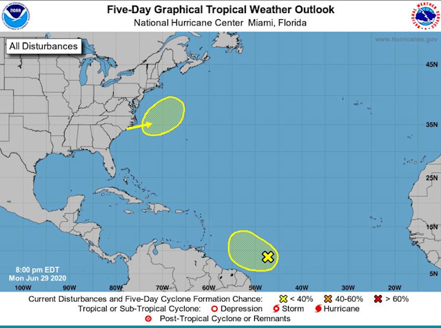
|
|
- - - 2020 Hurricane Season - - -
|
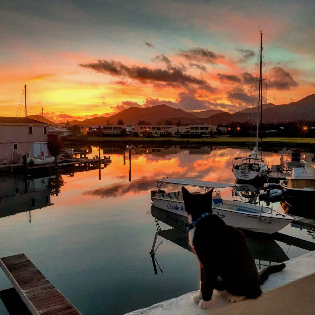
- Sunrise In Antigua
|
- By Steve Selim <stevenselim at gmail.com>
- Date: Fri, 15 Jan 2021 15:25:05 -0400
|
|

|
|
- ANTIGUA WEATHER
|
- By Martha Watkins Gilkes <marthawatkinsgilkes at gmail.com>
- Date: Tue, 10 Nov 2020 09:42:56 -0400
|
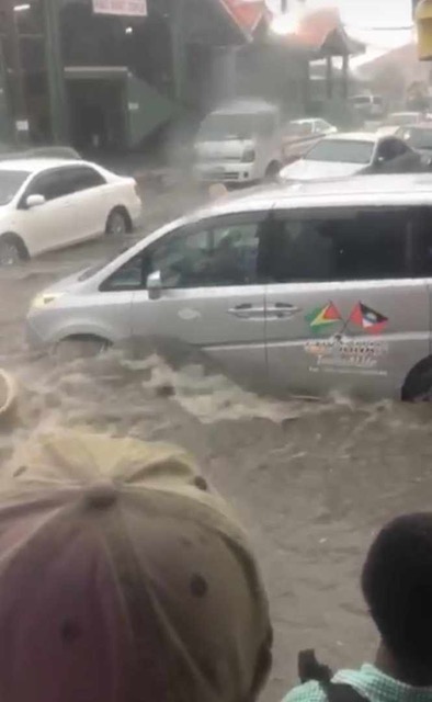
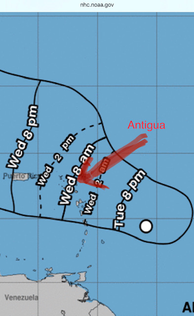
Antigua & Barbuda have had HEAVY RAINS the last day and it continues for a couple of days with the passing of the weather described below on our MET OFFICE SITE. WE had serious flooding yesterday and today many places are CLOSED due to the flooding. SO WE ARE WEATHER WATCHING but thankful it is not a HURRICANE. Synopsis: An area of disturbed weather has developed just southwest of the Leewards. Whereas significant development is not anticipated in the short-term, the combination of a southeasterly windflow, aided by a moist environemnt and critical upper support, favors the formation of moderate to heavy precipitation over the Leewards later today and into tonight. As a result, a flash Flood watch is in effect. Rainfall accumulation could total between 25.4 to 76 mm or 1 to 3 inches. Residents are advised that the watch could be upgraded to an advisory or warning at short notice Weather today: Cloudy to Overcast with occasional showers some of which will be moderate to heavy this afternoon. There is also a moderate chance of afternoon thunderstorms |
|
|
- Storm Wilfred
|
- By Martha Watkins Gilkes <marthawatkinsgilkes at gmail.com>
- Date: Sun, 20 Sep 2020 18:24:16 -0400
|
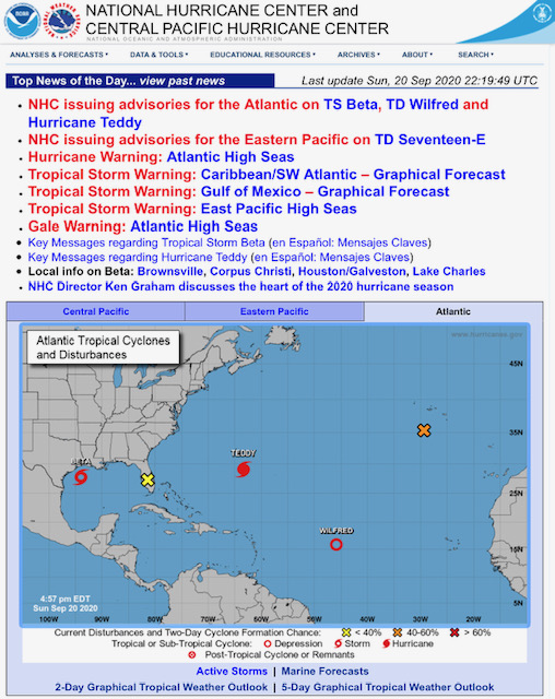
Thankful  this storm seems to be breaking up and most like we will have no
effects.

Martha Watkins Gilkes
P.O. Box W1924
Antigua, West Indies
268 460 4423
Cell 2687647722
Sent from my  fab iPhone
Marthawatkinsgilkes at gmail.com
|
|
- Disturbance #2 watching.
|
- By Martha Watkins Gilkes <marthawatkinsgilkes at gmail.com>
- Date: Wed, 16 Sep 2020 15:50:41 -0400
|
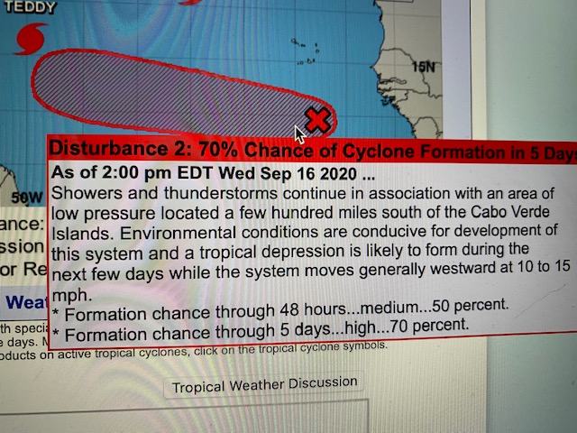
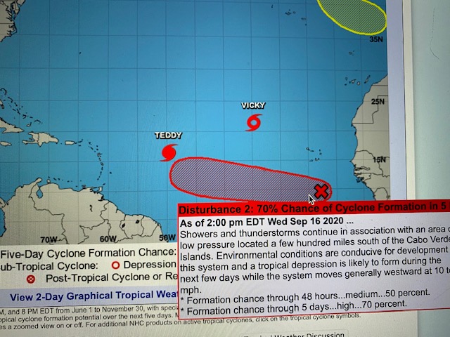
Watching to see if this one takes the north turn !


Martha Watkins Gilkes
P.O. Box W1924
Antigua, West Indies
268 460 4423
Cell 2687647722
Sent from my  fab iPhone
Marthawatkinsgilkes at gmail.com
|
|
- Weather in the Atlantic
|
- By Martha Watkins Gilkes <marthawatkinsgilkes at gmail.com>
- Date: Sat, 12 Sep 2020 07:57:38 -0400
|
Wierd times!  this morning as we start our  weekend..... not a leaf blowing on
a tree (perfect  day to be  at sea with such calm waters)  and we have this
EXCESSIVE HEAT  ALERT on our warning system ....and  all of these  hurricanes
and   potential storms dancing around  us!   and meanwhile watching
internationally how COVID is on the rise and countries are  having to lock down
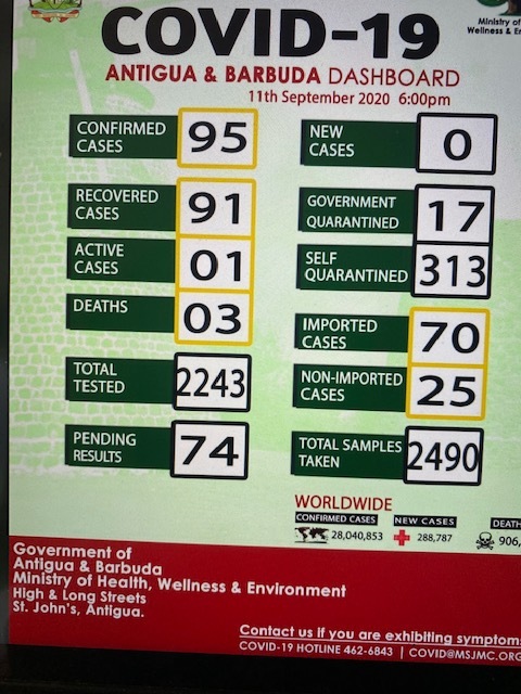
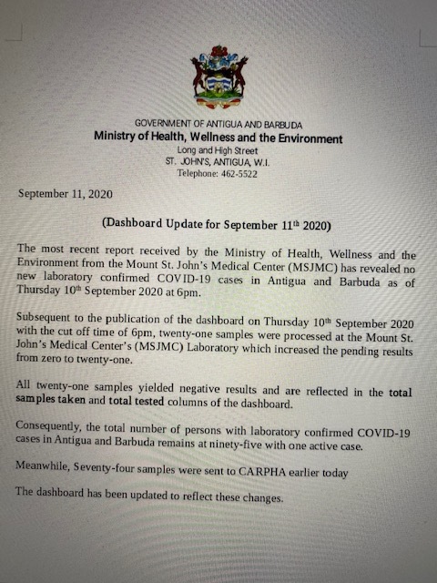
AGAIN and thankful antigua remains with  only  3 deaths and ONE ONLY  Active
case as our Government continues to keep things in check  ( we are  still in a
state of emergency with curfew and mask wearing in public and many other
"restrictions"  that  seem to be  working !)  I  am grateful to be
"sheltering"  here in this  tropical paradise.   HAPPY WEEKEND to all and keep
safe !


Martha Watkins Gilkes
P.O. Box W1924
Antigua, West Indies
268 460 4423
Cell 2687647722
Sent from my  fab iPhone
Marthawatkinsgilkes at gmail.com
|
|
- Active Atlantic
|
- By Martha Watkins Gilkes <marthawatkinsgilkes at gmail.com>
- Date: Fri, 11 Sep 2020 13:59:04 -0400
|
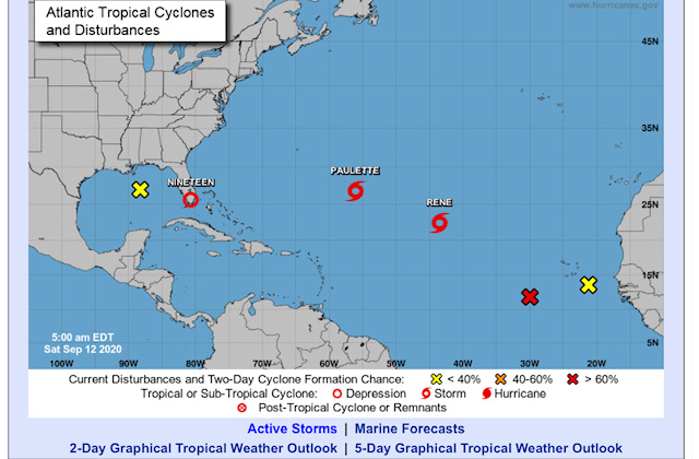
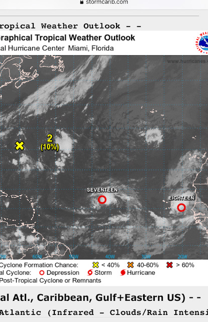
As we sadly reflect on Sep 11th  we are also watching all this Atlantic action.
  The one is red is of concern as it moves west towards the 🌴 islands.  Stay
alert all

Martha Watkins Gilkes
P.O. Box W1924
Antigua, West Indies
268 460 4423
Cell 2687647722
Sent from my  fab iPhone
Marthawatkinsgilkes at gmail.com
|
|
- Heat wave in Antigua
|
- By Martha Watkins Gilkes <marthawatkinsgilkes at gmail.com>
- Date: Fri, 11 Sep 2020 13:50:19 -0400
|
|


Excess Heat Warning in Effect for Antigua and Barbuda from 10 am to 4 pm Until MondayEffective 11th September 2020 12:45 pm Expires 12th September 2020 11:45 am Description Synopsis: Light winds will allow for the heat index to rise to excessive levels – dangerous hot conditions. The threat of health problems, for mainly sensitive people is forecast to be high. An excess heat warning is issued when the combination of heat and humidity is expected to make the temperature feels like 42 °C or 108 °F or higher, for two or more consecutive days.
Sensitive groups: While extreme heat can put everyone at risk for heat illnesses, health risks are greatest for the elderly, young children, people with chronic illnesses such as breathing difficulties, heart conditions or psychiatric illnesses, people who work or who exercise in the heat, homeless people and low-income earners.
Potential Health implications: Heat illnesses, including heat cramps, heat exhaustion and heat stroke. Heat illnesses can lead to long-term health problems and heat stroke can lead to death. Instructions If any symptoms of health illness are present (such as dizziness or fainting, nausea or vomiting, headache, rapid breathing and heartbeat, or extreme thirst) immediately move to a cool place and drink liquids; water is best. The most dangerous heat illness is heat stroke, with symptoms that include complete or partial loss of consciousness or confusion and high body temperature. If caring for someone with those symptoms, call 911 immediately. While waiting for help, cool the person right away by moving them to a cool place, applying cold water to large areas of the skin or clothing and fanning the person as much as possible.
Everyone should stay alert and take precaution – stay cool and hydrated. Check on vulnerable family members, friends and neighbours. Those who take medication or have a health condition should ask their doctor if it increases their health risk in the heat and follow their recommendation.
Stay tuned to updates coming out of the Met Office via antiguamet.com and facebook.com/abmetservice I’ll Contact ABMS Met Office at 462-3017, if confirmation of this message is needed. |
|
|
- Weather
|
- By Martha Watkins Gilkes <marthawatkinsgilkes at gmail.com>
- Date: Mon, 7 Sep 2020 06:30:09 -0400
|
As we start another week thankful it looks like both systems we are watching
will go North

Martha Watkins Gilkes
P.O. Box W1924
Antigua, West Indies
268 460 4423
Cell 2687647722
Sent from my  fab iPhone
Marthawatkinsgilkes at gmail.com
|
|
- watching MONSTER HURRICANE LAURA about to hit
|
- By Martha Watkins Gilkes <marthawatkinsgilkes at gmail.com>
- Date: Wed, 26 Aug 2020 19:21:57 -0400
|
IT IS HEART BREAKING TO watch this.. i have family in this area and it is going to be so devastating .. For us in the islands such a storm is the same but we are more hurricane savvy' and ready to ride out the after math much better with cisterns and water supply and generators and more "seasoned" so my heart goes out to so many who will be so effected.. a nightmare.. I pray for life ! Hard to believe we went thru the MILD LAURA this time last week ( on Friday ) .. we will soon enter SEPTEMBER … our peak month. WE all need to be alert for such a hurricane coming our way
|
|
|
- After Storm Laura. Saturday morning
|
- By Martha Watkins Gilkes <marthawatkinsgilkes at gmail.com>
- Date: Sat, 22 Aug 2020 07:10:31 -0400
|
Good morning on this Saturday morning!   Antigua and Barbuda in the all clear
as you see in this official release.  We are still having gusty winds and may
get a few more showers (hopefully)  but were spared anything serious !  Still
have September to face so perhaps a good practice run. Even if a big pain to
shutter up !!!  Thankful I am reporting this !! Have a great weekend 🌴


Martha Watkins Gilkes
P.O. Box W1924
Antigua, West Indies
268 460 4423
Cell 2687647722
Sent from my  fab iPhone
Marthawatkinsgilkes at gmail.com
|
|
- Update
|
- By "Brian P. Mangum" <epidemiology.doc at gmail.com>
- Date: Fri, 21 Aug 2020 16:15:28 -0400
|
Here on Antigua we have had about two hours of moderate rain, but the big news was the lightning and thunderstorm which put on quite the show before moving on to the west.
Right now, we can actually see across the bay towards the open ocean, and things appear clear. I estimate that we can see about 30 miles to the horizon from our height at 380 ft above sea level.
The winds have come up a little, allowing us to open the house and get a nice cross breeze, as earlier when the lightning was active and we had the house closed up it was very, very humid. Reminds me of the humidity of the South Pacific such as in PNG.
We anticipate that the presence of the storm will make itself more widely felt as the afternoon progresses, and into the evening hours, with the CPA still being around 1800 hours. The barometer continues to fall, and right now stands at 995.15 mb with 89% relative humidity at 27 C.
Stay safe! |
|
- Update
|
- By "Brian P. Mangum" <epidemiology.doc at gmail.com>
- Date: Fri, 21 Aug 2020 12:44:02 -0400
|
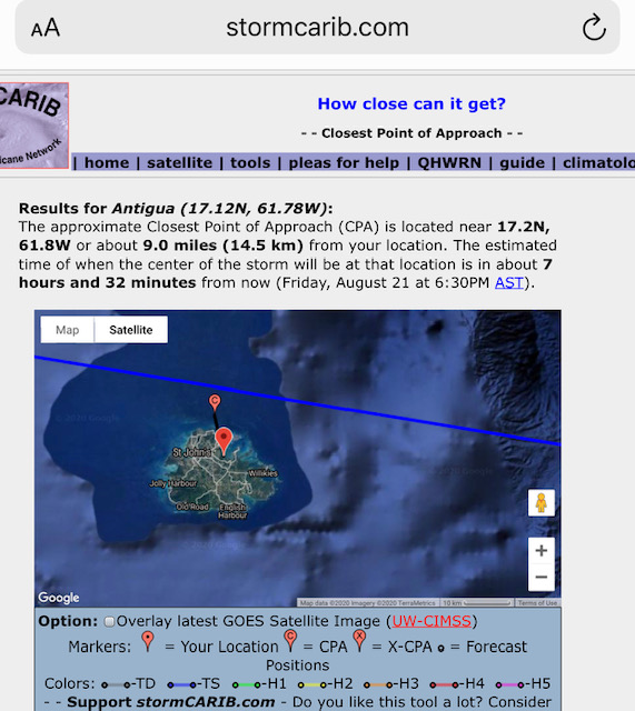
Hello all, Closest point of approach for ANU: 9 miles north, today at 1830 hours. Anticipate the arrival of the winds around 1400 hours AST, and are in the 60-70% range of receiving tropical storm force winds (>39mph). Locally, there has been very little guidance from the emergency management agency. I have lived in the tropics over fifteen years, having passed through several super typhoons in the Pacific, including Winston and Yutu. Even though this is not a cyclone, they have not been very proactive, and have been downplaying the risk. Consequently, in public, it is business as usual, and there was even talk that they were going to cancel the storm warning. Stay safe! |
|
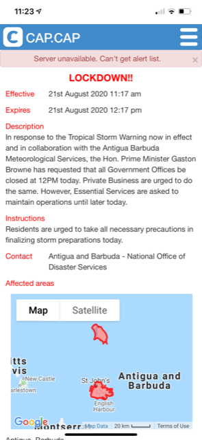
- Antigua on lockdown
|
- By Martha Watkins Gilkes <marthawatkinsgilkes at gmail.com>
- Date: Fri, 21 Aug 2020 11:28:21 -0400
|
Just in.

Martha Watkins Gilkes
P.O. Box W1924
Antigua, West Indies
268 460 4423
Cell 2687647722
Sent from my  fab iPhone
Marthawatkinsgilkes at gmail.com
|
|
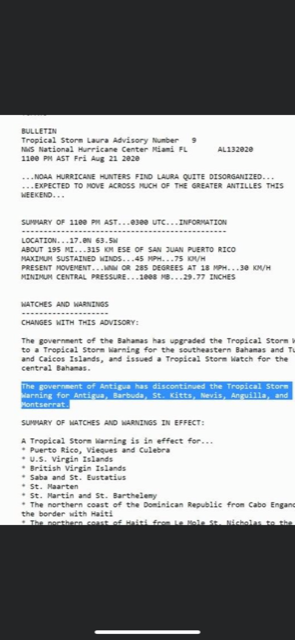
- Tropical storm Laura.
|
- By Martha Watkins Gilkes <marthawatkinsgilkes at gmail.com>
- Date: Fri, 21 Aug 2020 11:06:14 -0400
|
Tropical Storm Laura  now will pass very close to Antigua and Barbuda.  This
track puts it only 9 miles from us.    Could move even closer and should get
effects later this afternoon. Hope all are prepared as we have been saying 😱.
Be safe Antigua.  At least we are not facing a Cat 4 hurricane but of course
can still have damage


Martha Watkins Gilkes
P.O. Box W1924
Antigua, West Indies
268 460 4423
Cell 2687647722
Sent from my  fab iPhone
Marthawatkinsgilkes at gmail.com
|
|
- Latest on weather
|
- By Martha Watkins Gilkes <marthawatkinsgilkes at gmail.com>
- Date: Fri, 21 Aug 2020 09:14:55 -0400
|
Game changer here.   Just in and spoke to Met Office.  This storm seems to be
to the south of Antigua and may place it passing right over us !  Late
afternoon today Friday thru midday tomorrow.

Was advised to listen to 11 am update and especially 2 pm.    We may get gusty
winds and badly needed rains

Update:
TCUAT3

Tropical Storm Laura Tropical Cyclone Update
NWS National Hurricane Center Miami FL       AL132020
905 AM AST Fri Aug 21 2020

...NOAA HURRICANE HUNTER AIRCRAFT FINDS THAT THE DEPRESSION HAS
STRENGTHENED TO TROPICAL STORM LAURA...

Data from a NOAA Hurricane Hunter aircraft indicate that Tropical
Depression Thirteen has strengthened and is now Tropical Storm
Laura with maximum sustained winds of around 45 mph (75 km/h). The
aircraft also found that the center of Laura is located south of the
previously estimated position. These changes will be reflected in
the track and intensity forecasts with the upcoming advisory that
will be issued at 1100 AM AST (1500 UTC).
|
|
- Antigua weather watching
|
- By Martha Watkins Gilkes <marthawatkinsgilkes at gmail.com>
- Date: Thu, 20 Aug 2020 09:51:22 -0400
|
This morning  we are  not much better advised from ANY  WEATHER SOURCES   on
what to expect for now  #13   (Could become  LAURA)    It is a  DEPRESSION  now
 but  conditions are  favorable for development  but  the path is not
certain... seems it will  track NORTH OF  Antigua  &  Barbuda but that  is not
written in  stone  so it could  be much closer to us.  I spoke to the MET
OFFICE  just now and  they  advised  each person  must decide on  how
vulnerable  your  house location  is  and if  you need  to  put up  hurricane
shutters  !   For Me  I WILL DO MORE   RATHER THAN LESS... once  the ILL WINDS
START TO BLOW  IT WILL BE TOO LATE..   so better  safe than sorry.  IT  appears
  FRIDAY NIGHT  the  system will be the closest  to us....

Martha Watkins Gilkes
P.O. Box W1924
Antigua, West Indies
268 460 4423
Cell 2687647722
Sent from my  fab iPhone
Marthawatkinsgilkes at gmail.com
|
|
- Storm coming
|
- By Martha Watkins Gilkes <marthawatkinsgilkes at gmail.com>
- Date: Wed, 19 Aug 2020 20:00:52 -0400
|
Looks like we may get a blow. We should all be in a state of readiness !!

Martha Watkins Gilkes
P.O. Box W1924
Antigua, West Indies
268 460 4423
Cell 2687647722
Sent from my  fab iPhone
Marthawatkinsgilkes at gmail.com
|
|
- On the weather!!
|
- By Martha Watkins Gilkes <marthawatkinsgilkes at gmail.com>
- Date: Wed, 19 Aug 2020 15:57:15 -0400
|
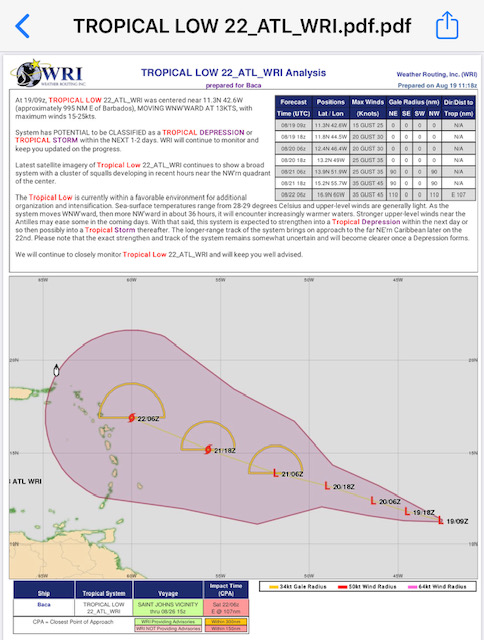
To check out more on the system near Antigua
|
|
|
- ANTIGUA BARBUDA on TROPICAL CYCLONE ALERT
|
- By Martha Watkins Gilkes <marthawatkinsgilkes at gmail.com>
- Date: Wed, 19 Aug 2020 10:46:50 -0400
|
The Following  just out from our  MET OFFICE…  so  we are watching !  Hopefully
 it will  not be  any  serious  damaging  winds but  will bring us  very needed
 RAIN.      Stay  WEATHER  ALERT ALL.


Tropical Cyclone Alert in Effect
Effective19th August 2020 9:53 am
Expires20th August 2020 8:53 am
Description
A tropical cyclone alert (TCA) is in effect for Antigua and Barbuda. The TCA
means, in this case, that there is a tropical disturbance (Tropical Disturbance
AL98) in our monitored area; however, a tropical cyclone watch or warning is
not required, at this time but could become necessary in the near future.

Given the normal uncertainty in the forecast track, intensity and size of the
developing tropical cyclone, it is impossible to predict what exact
tropical-cyclone-hazard values, if any, are expected to occur this far in
advance. Notwithstanding, the threat level, based on the reasonable worst-case
scenario, is elevated. There is the potential for limited impacts from
storm-force-winds, high seas and minor flooding, resulting in life-threatening
conditions, disruptions to daily life and minor damage to infrastructure. To be
safe, have your hurricane disaster plan ready for execution and monitor closely.

At 8 am this morning, Tropical Disturbance AL98 was located about 1240 miles
east-southeast of Antigua and Barbuda moving west-northwest at around 18 mph.
This general motion is expected to continue for the next few days.

Maximum sustained winds are less than 35 mph. Strengthening is forecast and a
tropical cyclone, in this case, a tropical depression or storm, is expected to
form in 48 hours.

Most models have Tropical Disturbance AL98 becoming a tropical storm – Tropical
Storm Laura, and passing near or over Antigua and Barbuda late Friday or
Saturday. Hence, there is the potential for limited damage to property along
with financial losses, as the country may have to close, for a while, perhaps
similarly to when we had Potential Tropical Cyclone Nine. However, it is still
relatively early days and the system could still spare us any harm.

A tropical cyclone watch will likely be required in the next 24 hours.
Instructions
Residents are advised to monitor this developing system closely and have their
hurricane plans prepared, as the system has the potential to cause
life-threatening conditions and property damage this weekend.
ContactABMS Met Office at 462-3017, if confirmation of this message is needed
|
|
- Mistaken
|
- By Martha Watkins Gilkes <marthawatkinsgilkes at gmail.com>
- Date: Tue, 18 Aug 2020 06:41:31 -0400
|
In my last post I was wrong. #2 much further away that 700 miles from us. So
won’t be in the islands for  5 to 7 days !
|
|
- Weather
|
- By Martha Watkins Gilkes <marthawatkinsgilkes at gmail.com>
- Date: Tue, 18 Aug 2020 06:06:35 -0400
|
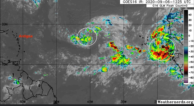
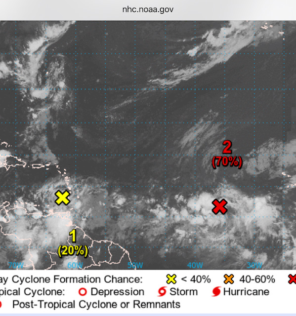
I posted on Sunday about these 2 systems
The #1 is moving through the windward islands now   Already.   shown here.
Bringing badly needed rain to Barbados.
  Antigua is just above the yellow X
#2  is 700 miles out moving 15 to 20 mph so about 30 to 40 hours away but not
yet formed or not named  and the path is not known.
     So we watch and be ready if quick boarding up needed !

|
|
- Rough seas
|
- By Martha Watkins Gilkes <marthawatkinsgilkes at gmail.com>
- Date: Mon, 17 Aug 2020 06:25:10 -0400
|
| Good morning on this Monday morning!
We are watching the weather and have this advisory out as our seas are rough ! Urgent Marine Weather Message - A Small Craft Advisory is in Effect Until Tuesday NightEffective 17th August 2020 12:43 am Expires 17th August 2020 11:43 pm Description Fresh winds, due the tightening of the pressure gradient, are expected to cause hazardous seas, raising threat level to moderate, at sea, with the potential of significant impacts to the life and property of mariners. The threat level could rise to high levels Monday night when seas are likely to reach over 2.5 metre (9 feet); a warning may be required then.
|
|
|
- Sunday morning weather
|
- By Martha Watkins Gilkes <marthawatkinsgilkes at gmail.com>
- Date: Sun, 16 Aug 2020 09:35:15 -0400
|
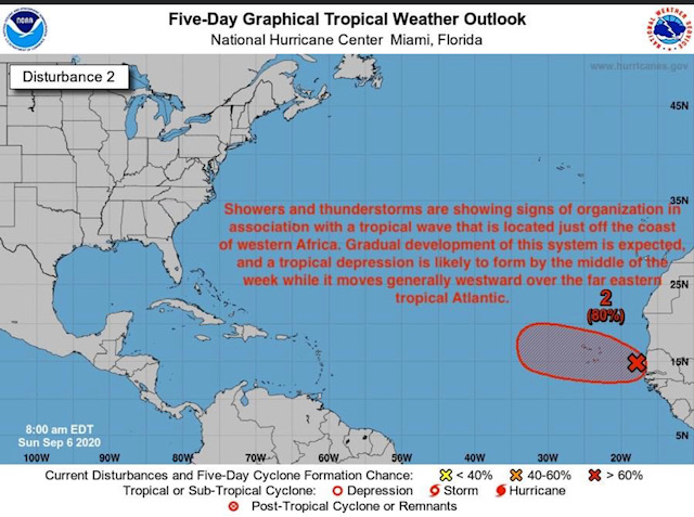
Waking this morning to this  probably coming our way !    Never a dull moment!
 The first one may not be too bad  as it is moving fast which may hinder
development. But the second system is anyone’s guess and a long way out —maybe
a week from us !   Key is as always be prepared!!
Happy Sunday to those weather watchers reading this   🙏

Martha Watkins Gilkes
P.O. Box W1924
Antigua, West Indies
268 460 4423
Cell 2687647722
Sent from my  fab iPhone
Marthawatkinsgilkes at gmail.com
|
|
- Goodbye to Storm Josephine
|
- By Martha Watkins Gilkes <marthawatkinsgilkes at gmail.com>
- Date: Sun, 16 Aug 2020 09:26:05 -0400
|
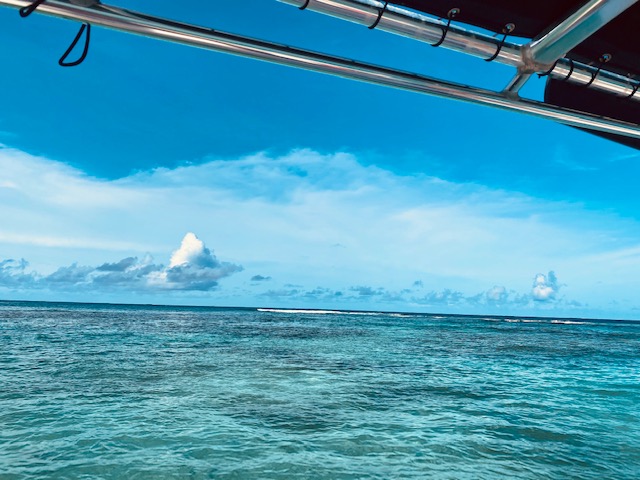
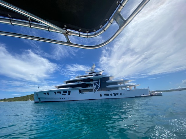
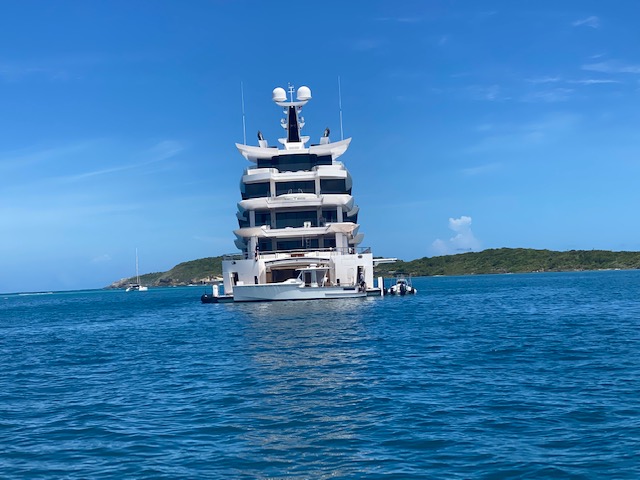
Yesterday went to sea to watch the edge of the storm  Josephine about 160 miles
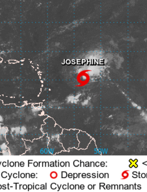
to our north.  Clouds shown here.    And very unusual to come across this super
yacht Artefact in our waters in hurricane season!  Goggle  her for some amazing
facts and the Greek owner !!


Martha Watkins Gilkes
|
|
- Calm weather
|
- By Martha Watkins Gilkes <marthawatkinsgilkes at gmail.com>
- Date: Sat, 15 Aug 2020 06:34:56 -0400
|
On this early Saturday morning we are wakings up to totally calm weather.
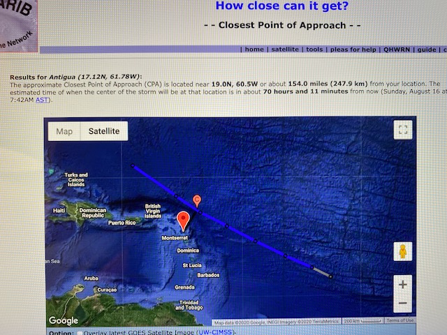
Hardly a  leaf is blowing!   seems Tropical Storm Josephine has moved more
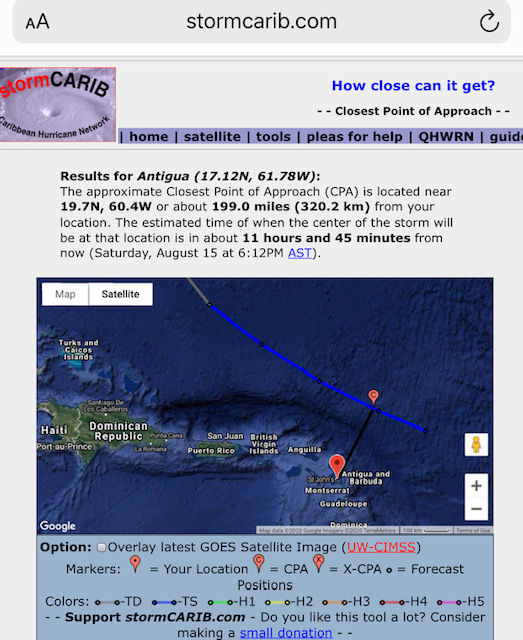
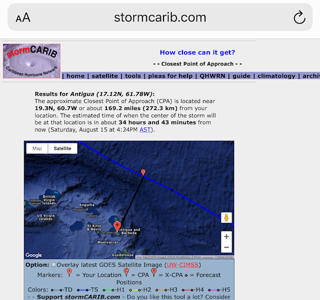
north of us  according to Stormcaribs tool on How close can it get !   Lucky 🍀
again and hopefully my Bermuda 🇧🇲 friends will be spared as the storm moved
north  We still have September to face — our most active hurricane month so
still eyes to the East !  But very thankful not to be packing up garden
umbrellas and “things” on this day !   I wish a Lovely weekend to you !

Martha Watkins Gilkes
|
|
- Tropical storm Josephine
|
- By Martha Watkins Gilkes <marthawatkinsgilkes at gmail.com>
- Date: Fri, 14 Aug 2020 06:12:15 -0400
|
The storm has made a slight north turn thankfully But our Met Office advises this
WE ARE NOT YET OUT OF THE WOODS. THERE IS STILL THE POTENTIAL FOR THE TURN NOT TO BE ENOUGH, RESULTING IN JOSEPHINE BRINGING BARBUDA AND TO A LESSER EXTENT ANTIGUA STORM-FORCE-WINDS AND HIGH SEAS ON SATURDAY - A REASONABLE WORST-CASE SCENARIO THAT CANNOT BE OVERLOOKED.
On the projected track the closest to Us is 160 miles to the North But tracks Change so be prepared! Keep safe all 
Martha Watkins Gilkes P.O. Box W1924 Antigua, West Indies 268 460 4423 Cell 2687647722 Sent from my fab iPhone Marthawatkinsgilkes at gmail.com
|
|
|
- Storm coming towards Antigua
|
- By Martha Watkins Gilkes <marthawatkinsgilkes at gmail.com>
- Date: Thu, 13 Aug 2020 22:13:11 -0400
|
I never took down my hurricane shutters from the last storm.    thankful lots
less to Prepare but still
Looking to the East.    For the next one


Martha Watkins Gilkes
P.O. Box W1924
Antigua, West Indies
268 460 4423
Cell 2687647722
Sent from my  fab iPhone
Marthawatkinsgilkes at gmail.com
|
|
- Antigua weather
|
- By Martha Watkins Gilkes <marthawatkinsgilkes at gmail.com>
- Date: Wed, 12 Aug 2020 18:31:39 -0400
|
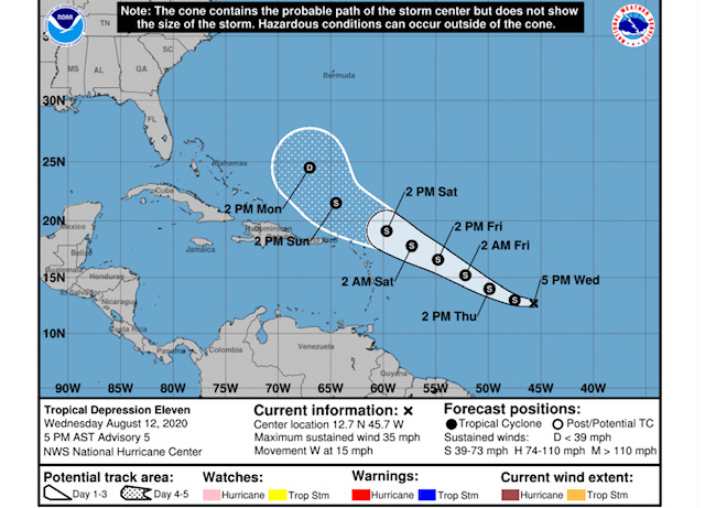
Tropical Depression 11 has formed in the Atlantic. The depression is likely to be upgraded to a Tropical Storm within the next 24 hours and is expected to pass north of Antigua over the weekend. Please click on this link https://www.nhc.noaa.gov/graphics_at1.shtml?start#contents for further details. Currently, there is high uncertainty regarding the magnitude of the potential impact that this storm will have on the island. However, we should be prepared to experience high winds, storm surges, and flooding. |
|

Martha Watkins Gilkes P.O. Box W1924 Antigua, West Indies 268 460 4423 Cell 2687647722 Sent from my fab iPhone Marthawatkinsgilkes at gmail.com
|
|
|
- August look out
|
- By Martha Watkins Gilkes <marthawatkinsgilkes at gmail.com>
- Date: Sun, 9 Aug 2020 11:20:59 -0400
|
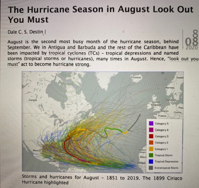
Our Antigua weather guru says look out given our history of August Hurricanes.
 We know September is our most active month however !
Keep eyes to the East.

Martha Watkins Gilkes
|
|
- July 2020 hurricanes
|
- By Martha Watkins Gilkes <marthawatkinsgilkes at gmail.com>
- Date: Sun, 2 Aug 2020 06:02:59 -0400
|
2020 strikes again !!!!
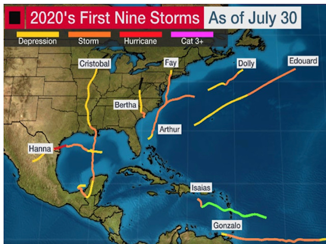
According to our Met office and Mr Dale Westin. July stand by turned out to be a historic month. This July tied with July 2005 for the greatest number of Atlantic named storms – five, for the month, on record dating back to 1851. It was also the first time since 1996 Antigua and Barbuda experienced sustained storm-force winds.
Now to get thru August and September!!!

|
|
|
- Continued Weather Watching
|
- By Martha Watkins Gilkes <marthawatkinsgilkes at gmail.com>
- Date: Sat, 1 Aug 2020 08:54:25 -0400
|
As we enter the weekend we are sorry to see the hurricane heading thru our
sister islands 🌴 especially the Bahamas.  And now to Florida.  We are watching
these 2 other systems out in the Atlantic now.   We have August and September
to get thru!   I have left most of my hurricane shutters in place !   We
continue to be vigilant.   This would have been our big Carnival weekend in
Antigua.  A major cultural event. Cancelled due to Covid !    Monday Tuesday
holidays !   A very different new norm !

Martha Watkins Gilkes
P.O. Box W1924
Antigua, West Indies
268 460 4423
Cell 2687647722
Sent from my  fab iPhone
Marthawatkinsgilkes at gmail.com
|
|
- Waves. Coming in Half moon bay
|
- By Martha Watkins Gilkes <marthawatkinsgilkes at gmail.com>
- Date: Wed, 29 Jul 2020 15:08:41 -0400
|
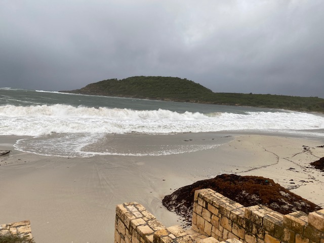
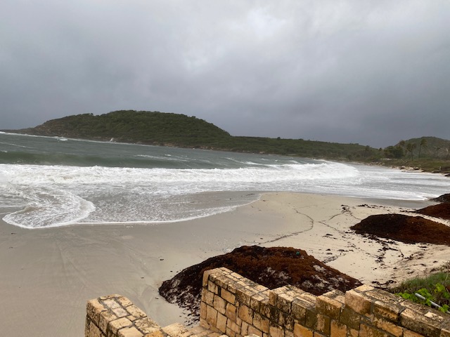
After the storm.     Waves 🌊 still rolling in.
Wind still gusty


Martha Watkins Gilkes
P.O. Box W1924
Antigua, West Indies
268 460 4423
Cell 2687647722
Sent from my  fab iPhone
Marthawatkinsgilkes at gmail.com
|
|
- As the storm is passing
|
- By Martha Watkins Gilkes <marthawatkinsgilkes at gmail.com>
- Date: Wed, 29 Jul 2020 12:19:20 -0400
|
|
|
|
- Potential Tropical Cyclone 9
|
- By Daniella Seepaul <daniellaseepaul at gmail.com>
- Date: Tue, 28 Jul 2020 22:56:37 -0400
|
Hi Fellow Islanders,
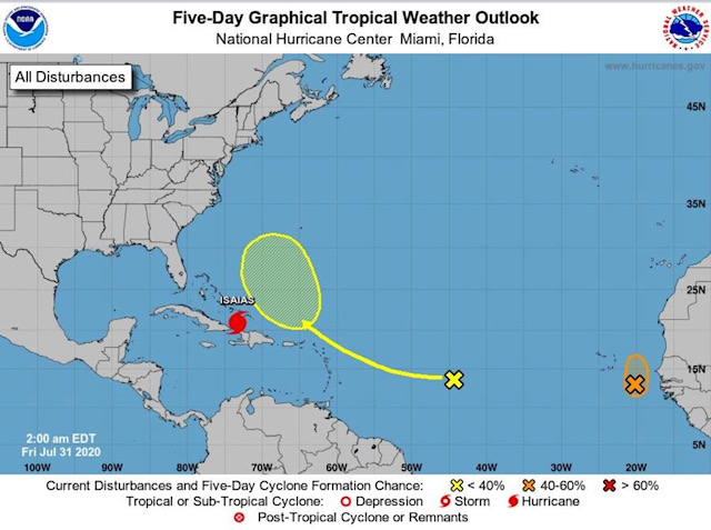
As PTC9 "future TS Isaias" passes our islands the national office of disaster services (Nods) have ordered a national shut down for the islands of Antigua and Barbuda tomorrow, and the Antigua met office just issued a flash flood watch for Antigua, Barbuda, Nevis, and Anguilla.
Be safe everyone!
Regards, Daniella Seepaul |
|
- Storm ready
|
- By Martha Watkins Gilkes <marthawatkinsgilkes at gmail.com>
- Date: Tue, 28 Jul 2020 17:37:11 -0400
|
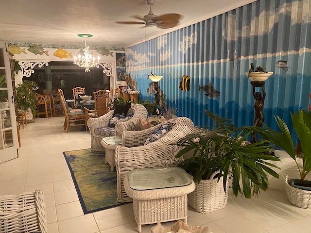
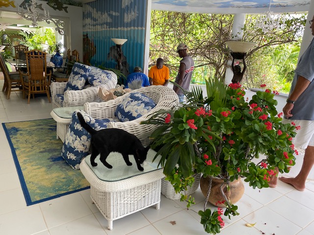
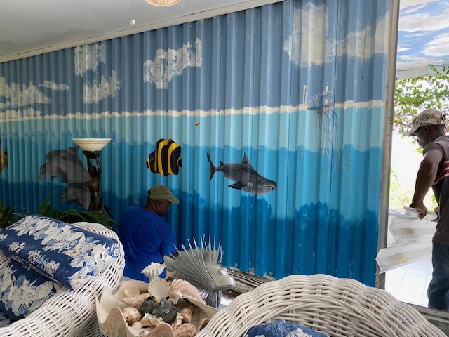
Boarding up as better to be safe than sorry!!! A bit of a pain but smart thing
to do !!    Actually nice to behind my under the sea themed hurricane shutters
painted by a fab group of girlfriends!!! This  Storm is an odd one.   Not  a
clear pattern on the course yet   But they say. Antigua will start getting
this Tonight and all tomorrow...... heavy rain predicted.     Keep safe my
fellow Antiguans !!!!


|
|
- WATCHING AND WAITING
|
- By Martha Watkins Gilkes <marthawatkinsgilkes at gmail.com>
- Date: Mon, 27 Jul 2020 14:11:43 -0400
|
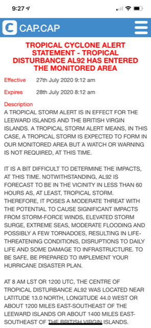
We continue to watch 92L and as of TODAY the HURRICANE HUNTERS will start to fly the system aslisted below. I always like to see that because that means
we will get much more accurate data than just the sat reading This i a summary of the activity..so it continues westward to west northwestward ( would like to see a more NORTH TURN but that is not happening yet. Shower activity associated with a broad area of low pressure located
about 1000 miles east of the Windward Islands has changed little in
organization since this morning. Environmental conditions are
expected to become somewhat more favorable for development during
the next few days and a tropical depression or tropical storm is
likely to form during that time frame. The system is forecast to
move westward to west-northwestward at 15 to 20 mph and it could
bring heavy rain to portions of the Leeward Islands by late
Wednesday, regardless of development. As we have stated to early to tell if we will get something or not and i have seen them coming when we boarded up and NOTHING CAME…and we were all
cursing the major effort made to have a NON EVENT but better SAFE THAN SORRY PEOPLE.. SO be prepared as everyone is saying
HURRICANE HUNTERS PLAN OF THE  DAY
NOUS42 KNHC 271452
REPRPD
WEATHER RECONNAISSANCE FLIGHTS
CARCAH, NATIONAL HURRICANE CENTER, MIAMI, FL.
1100 AM EDT MON 27 JULY 2020
SUBJECT: TROPICAL CYCLONE PLAN OF THE DAY (TCPOD)
         VALID 28/1100Z TO 29/1100Z JULY 2020
         TCPOD NUMBER.....20-062

I.  ATLANTIC REQUIREMENTS
    1. SUSPECT AREA (CENTRAL ATLANTIC)
       FLIGHT ONE - TEAL 73          FLIGHT TWO - TEAL 72
       A. 28/1800Z                   A. 29/0530Z
       B. AFXXX 01EEA INVEST         B. AFXXX 0209A CYCLONE
       C. 28/1500Z                   C. 29/0345Z
       D. 14.0N 53.0W                D. 15.5N 57.0W
       E. 28/1730Z TO 28/2200Z       E. 29/0500Z TO 29/0830Z
       F. SFC TO 10,000 FT           F. SFC TO 10,000 FT

       FLIGHT THREE - TEAL 71
       A. 29/1130Z,1730Z
       B. AFXXX 0309A CYCLONE
       C. 29/1000Z
       D. 16.0N 59.0W
       E. 29/1100Z TO 29/1730Z
       F. SFC TO 10,000 FT

    2. OUTLOOK FOR SUCCEEDING DAY:
       A. CONTINUE 6-HRLY FIXES IF SYSTEM DEVELOPS.
       B. POSSIBLE NOAA G-IV SYNOPTIC SURVEILLANCE MISSION AROUND
          THE SYSTEM FOR 30/0000Z, DEPARTING TISX AT 29/1730Z.
|
|
|
- Update
|
- By "Brian P. Mangum" <epidemiology.doc at gmail.com>
- Date: Mon, 27 Jul 2020 13:19:10 -0400
|
As 92L makes its way towards the Basin, there is considerable discussion as to what effect it will have.
The consensus among long-term residents here in Antigua seems to be that when storms have a potential track directly over the island at 48-72 hours out, that they generally turn to the north of us.
Still, it is never a bad idea to stock up and be ready. And of course, any rain that it brings in the outer bands will be welcome locally where the drought persists. Today we have received a decent amount of rain to go with what we had over the weekend. We even enjoyed another night of natural fireworks on the horizon overnight.
Stay safe! |
|
- Antigua Barbuda on storm alert
|
- By Martha Watkins Gilkes <marthawatkinsgilkes at gmail.com>
- Date: Mon, 27 Jul 2020 09:38:44 -0400
|
Antigua & Barbuda on a tropical storm alert.   This one a bit tricky as it is
only 1200 miles out  and could develop quickly.   Monitoring carefully!   All
eyes to the East !


Martha Watkins Gilkes
P.O. Box W1924
Antigua, West Indies
268 460 4423
Cell 2687647722
Sent from my  fab iPhone
Marthawatkinsgilkes at gmail.com
|
|
- SUNDAY MORNING WEATHER WATCHING
|
- By Martha Watkins Gilkes <marthawatkinsgilkes at gmail.com>
- Date: Sun, 26 Jul 2020 13:42:26 -0400
|
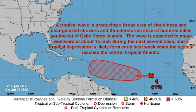
Good DAY and HAPPY SUNDAY to all checking on Gerts informative weather site! — thanks GERT for your continued effort in keeping this STORM CARIB site going in spite of all the efforts!
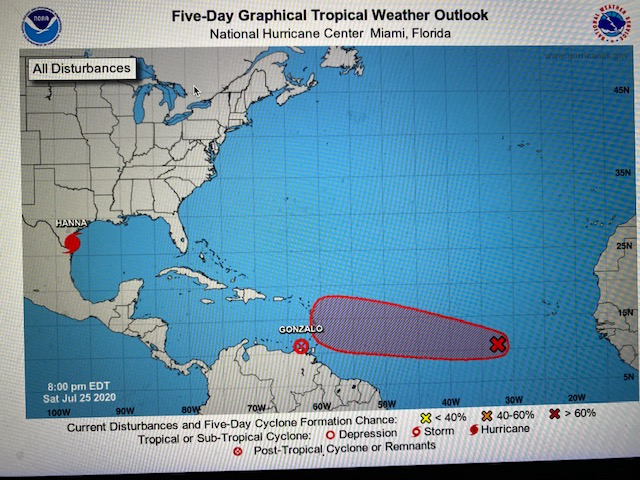
The system off in the ATLANTIC (pictured below) is pretty certain to develop.. Nat Hurricane center says 90% chance so pretty high % !!! but it is still TOO SOON TO KNOW WHAT it will develop into as it reaches the islands.. and WHERE IT WILL GO.. Looking like the path will be “THE NORTHERN LEEWARDS” - that includes US !! Antigua & Barbuda!! so HEADS UP HERE.. and while it is NOT TOO SOON TO “BE PREPARED” we cant know what we will get YET.. ( having said that I ALREADY JUST CLOSED UP MY GUEST COTTAGE with the Hurricane shutters as it is better to get that OUT OF THE WAY in case…. They are predicting around THURSDAY… so a few days still to “get ready”! WE in Antigua & Barbuda are hurricane savvy and know what to do…so we should all have our gasoline stash our grocery stash/ medical supplies/ drinking water ETC… EYES TO THE EAST !!! Enjoy your Sunday... |
|
|
- ANTIGUA STILL WEATHER WATCHING
|
- By Martha Watkins Gilkes <marthawatkinsgilkes at gmail.com>
- Date: Sat, 25 Jul 2020 20:53:08 -0400
|
We STILL HAVE ALL EYES to the east with another system that has formed and is expected to come our way in the next week or so. Suddenly things have become very active. Too early to know a path but all we should pay attention. The next few days will show more on the path.
|
|
|
- Watching
|
- By Martha Watkins Gilkes <marthawatkinsgilkes at gmail.com>
- Date: Fri, 24 Jul 2020 08:12:50 -0400
|
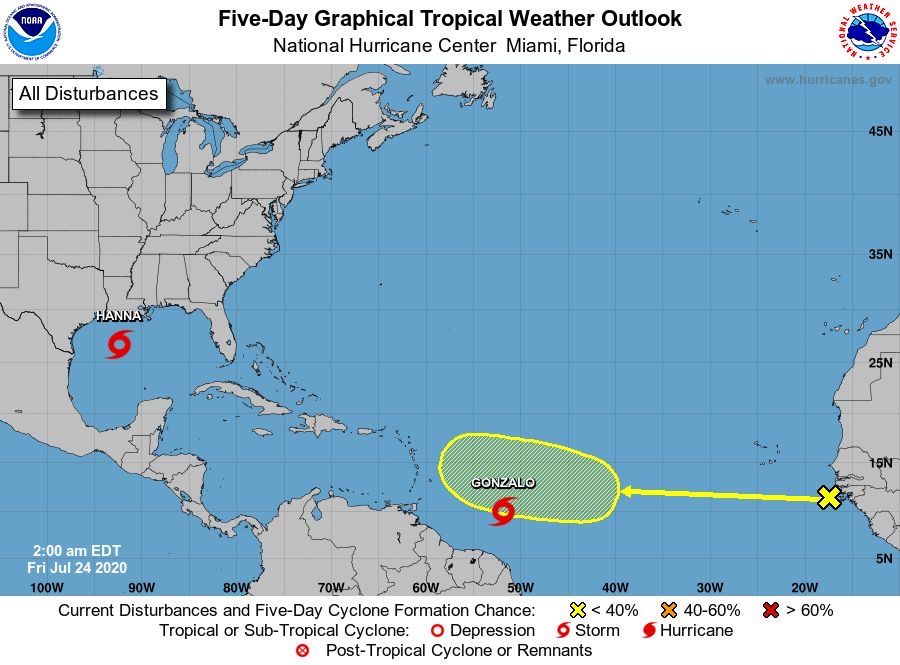
Good morning from Antigua
We are storm watching here.   Looks  like the system will stay south of the
Leewards but have  to monitor!   Also one just behind this one !!!  ‘Tis the
season!


Martha Watkins Gilkes
|
|
- Update
|
- By "Brian P. Mangum" <epidemiology.doc at gmail.com>
- Date: Fri, 24 Jul 2020 07:12:16 -0400
|
We have lived in the tropics for about ten years now. We have lived through cyclones, hurricanes, and typhoons. My kids even slept through TC Winston in Fiji, a super cat 5. But last night, we had one of the biggest electric storms I have ever seen. It was fantastic, until we also encountered the largest thunder clap we have ever heard. It shook the house, set off the alarm, scared the dog, and freaked out the adults and kids in the house. This morning, the rain has passed, and while I am not sure, I think this is the forefront of the Sahara Air Layer they are predicting for next week. Such a shame. |
|
- Update
|
- By "Brian P. Mangum" <epidemiology.doc at gmail.com>
- Date: Thu, 23 Jul 2020 07:33:23 -0400
|
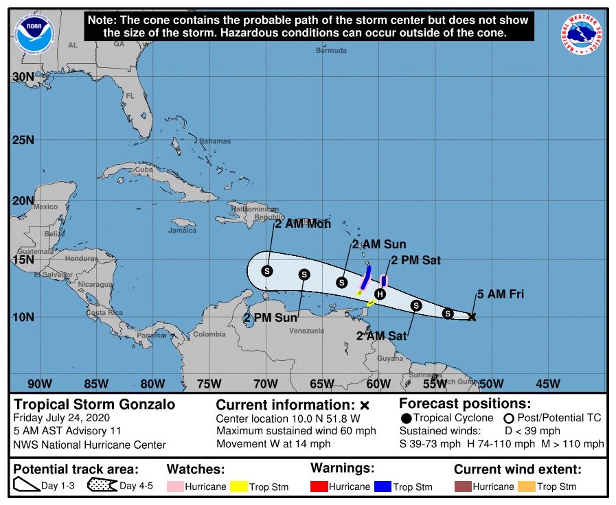
The outer bands of TS Gonzalo seem to be pushing some much-needed rain our way this morning. Since around 0430 we have been having a good amount of rain. Not as much as we were used to in the Pacific, but still enough I won't have to water the pot plants this morning, and the pool, cistern, and plants will get a good dousing. I have high hopes this will persist across the day, as we can certainly use the rain, even if the kids are disappointed about not taking a day trip to the beach. Go well! |
|
- Update
|
- By "Brian P. Mangum" <epidemiology.doc at gmail.com>
- Date: Wed, 22 Jul 2020 10:16:00 -0400
|
As we are watching the approach of TS Gonzalo, today is rainy and windy on the southeast corner of Antigua. Much needed water for the plants and the cistern. Plus, a cooler day in which to enjoy a bit of relaxation. Stay safe out there! |
|
- Antigua is watching
|
- By Martha Watkins Gilkes <marthawatkinsgilkes at gmail.com>
- Date: Tue, 21 Jul 2020 16:23:05 -0400
|
First serious system we are watching for development. Stand by for more

Martha Watkins Gilkes
P.O. Box W1924
Antigua, West Indies
268 460 4423
Cell 2687647722
Sent from my  fab iPhone
Marthawatkinsgilkes at gmail.com
|
|
- Tropical
|
- By Martha Watkins Gilkes <marthawatkinsgilkes at gmail.com>
- Date: Wed, 1 Jul 2020 06:08:48 -0400
|
Watching a tropical system.   Hoping we will get some badly needed rain!  Still
have some of the Sahara dust

|
|
- Update
|
- By "Brian P. Mangum" <epidemiology.doc at gmail.com>
- Date: Wed, 24 Jun 2020 05:57:49 -0400
|
|
As everyone is noting, the dust from the Sahara seems to be the worst in memory. Recent comments from scientists at the University of Puerto Rico suggest it’s the worst in fifty years. Yesterday, it was dark enough that the street lights were coming on at midday. Plus, we have the continued sargassum smell that seems to be getting worse over the past few days. Stay safe, everyone!
--
"Statistics or graphs are not optimal to understand the experience of suffering" Paul Farmer, MD, PhD, Harvard Medical Anthropologist and ID Physician |
|
- SAL Antigua
|
- By Daniella Seepaul <daniellaseepaul at gmail.com>
- Date: Mon, 22 Jun 2020 21:09:12 -0400
|
Hi Fellow Islanders,
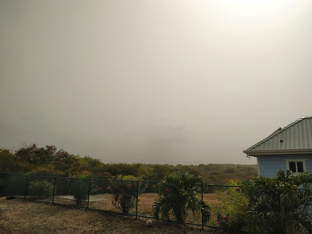
It's so weird heading outside to this great amount of dust over Antigua. It's almost apocalyptic. Just wanted to share two photos taken today. Stay safe!
Regards, Daniella Seepaul 

|
|
- Update
|
- By "Brian P. Mangum" <epidemiology.doc at gmail.com>
- Date: Mon, 22 Jun 2020 14:08:42 -0400
|
Here in Antigua, the Saharan Air Layer is the worst we have seen it thus far. We cannot even see the headland across the bay, let alone the horizon. Looking inland, things are quite hazy as well across the entire island. A dull, grey day. At the very least, we do have a nice breeze that is keeping things cool here at the house |
|
- Update
|
- By "Brian P. Mangum" <epidemiology.doc at gmail.com>
- Date: Fri, 19 Jun 2020 11:13:10 -0400
|
Happy Friday from Antigua! Windy with the Sahara dust layer really reducing visibility off the southeast corner of the island today. While the breeze is keeping things cool, it is also bringing more of the sargassum odour. A few clouds, but no rain. |
|
- Update
|
- By "Brian P. Mangum" <epidemiology.doc at gmail.com>
- Date: Tue, 9 Jun 2020 09:43:39 -0400
|
The weather here in Antigua has become increasingly hot as of the last week with little in the way of rain to cool things off or offer a little nourishment to the plants.
The hills, especially here in the southwest corner of the island, are a dusky brown with the brush slowly disappearing as we enter into summer. We continue to capture the shower water runoff to water the pot plants around the yard. Having spent the past decade in the Pacific, drought is a new (but rapidly recalled from our time in St Kitts and Nevis, as well as Aruba) experience for the family.
We rely on the trade winds coming in off the Atlantic side to cool our house, and with the slowing of the winds things are getting hotter. On the bright side, the influx of sargassum has slowed down, and with it the smell of sulfur that makes it feel like living atop an active volcano.
With the house open, and a few strategically placed feeders, we have had increasing numbers of Antillean Crested Hummingbirds and Caribbean Martins around, including inside the house. This is a real delight to the kids, and our little visitors always seem to find their way out of the French doors on either end.
We have also started to see the return of a limited number of tourists, with at least one of the villas near us having guests this week, including a young family.
Stay safe, everyone!
|
|
- Happy Silver Anniversary
|
- By "Brian P. Mangum" <epidemiology.doc at gmail.com>
- Date: Mon, 1 Jun 2020 17:25:59 -0400
|
Here in Antigua we continue hot and dry, with apparently little relieve in sight.
However, the real reason I am writing is to wish stormCARIB a happy twenty-fifth anniversary!
We have been living off an on in the Caribbean for the past decade, including St Kitts and Nevis, Aruba, and now Antigua and Barbuda, and stormCARIB has been a constant companion as a reliable source of information on what was happening weather-wise in the region.
A big thank you to stormCARIB and all of the amazing correspondents across the region - thank you for your service! Here's to 25 more years!
Cheers, Brian |
|
- TONIGHT MIDNIGHT END OF 2019 HURRICANE SEASON
|
- By Martha Watkins Gilkes <marthawatkinsgilkes at gmail.com>
- Date: Sat, 30 Nov 2019 20:37:06 -0400
|
| FOR MY WEATHER WATCHING friends ... tonight at MIDNIGHT our 2019 HURRICANE OFFICIALLy ends and we are breathing a BIG SIGH OF RELIEF. This has been a bad season as is so well summarized in this review by Mr. Dale Destin....with great respect. Each season it is a more anxious time for those of us "in harms way" with the changing weather patterns. My thoughts continue to go out to those in Bahamas who struggle to rebuild their lives and some never will. The aftermath of a hurricane is a hard time. For me the 1995 LUIS devastated our life and we were without electricity for FOUR ( YES 4) months after. But we rose again ! Hurricanes are a way of life it seems. So i wanted to share this review. Meanwhile we focus on the HOLIDAY SEASON and I wish a Happy Holiday time to all.
|
|
|
- Frightening super storm in the pacific
|
- By Martha Watkins Gilkes <marthawatkinsgilkes at gmail.com>
- Date: Mon, 7 Oct 2019 18:23:15 -0400
|
|
|
|
- ANTIGUA weather last few days
|
- By Martha Watkins Gilkes <marthawatkinsgilkes at gmail.com>
- Date: Wed, 25 Sep 2019 07:29:45 -0400
|
Download Attachment Available until Oct 25, 2019
Martha Watkins Gilkes P.O. Box W1924 Antigua, West Indies 268 460 4423 Cell 2687647722 Sent from my fab iPhone Marthawatkinsgilkes at gmail.com
|
|
|
- Tropical Storm Karen
|
- By Martha Watkins Gilkes <marthawatkinsgilkes at gmail.com>
- Date: Wed, 25 Sep 2019 05:53:14 -0400
|
We have had an unexpected rough 2 days weather wise.     At least on the
Atlantic side high on the hill (210 feet) above half moon bay.   We did not
expect this “lashing” from Tropical Storm Karen but we sure got it.    My phone
and internet still out and. Electricity been off and on for who knows when
And a few big tree branches been broken!    Not complaining looking at hard hit
 Bahamas   But we are having some challenges too.

Martha Watkins Gilkes
|
|
- Six named storms
|
- By Martha Watkins Gilkes <marthawatkinsgilkes at gmail.com>
- Date: Thu, 19 Sep 2019 20:54:23 -0400
|
Evidence of the terrible damage done to our environment... and the price we are
paying..   what makes my  blood boil is the fact that  the big  "industrial"
countries are the ones who have  caused the problem.. with the damage to the
ozone layer and with pollution  ..   we "small island states"  are   "fisher
folks, agricultural / farmers and  cause little harm in  comparison and yet  WE
ARE  THE ONES PAYING THE  BIG PRICE due to our location  in  "hurricane ally"
where these monster  storms come across and form and destroy our way of life  (
which is  a simple easy going  lovely way of living with  nature and our
surrounds)   THE BIG COUNTRIES dont  pay nearly the price  we do  living on an
isolated island where  there is not help when we are  "blown apart"   case in
point..  Beautiful little  Barbuda with HURRICANE IRMA and then HURRICANE MARIA
with "THE NATURE ISLAND  DOMINICA  2 years ago.. and now the  magnificent
BAHAMAS  just now..  sooo  terribly destroyed!  Because of what  "they "  have
and  are  doing.  IT MUST BE STOPPED.. People have to change their way of
living to protect "Mother earth"  before it is too late.

Martha Watkins Gilkes
|
|
- Antigua storm update
|
- By Martha Watkins Gilkes <marthawatkinsgilkes at gmail.com>
- Date: Thu, 19 Sep 2019 09:29:27 -0400
|
This morning good news with a more north turn of The Storm!  ANTIGUA In more of
the green which is good news
Still watching just in case a turn south.
We are very thankful.

Martha Watkins Gilkes
P.O. Box W1924
Antigua, West Indies
268 460 4423
Cell 2687647722
Sent from my  fab iPhone
Marthawatkinsgilkes at gmail.com
|
|
- Antigua now
|
- By Martha Watkins Gilkes <marthawatkinsgilkes at gmail.com>
- Date: Wed, 18 Sep 2019 20:39:39 -0400
|
Just posted by Dale Westin. Looking better for Antigua as no watch had been put
out for us.   Thinking of those in harms way.

Martha Watkins Gilkes
|
|
- Tropical Storm Jerry
|
- By Martha Watkins Gilkes <marthawatkinsgilkes at gmail.com>
- Date: Wed, 18 Sep 2019 14:54:01 -0400
|
The system is showing slight  south move closer to ANTIGUA . Fear for our
Sister isle BARBUDA  as it will be nearer there.

 The Hurricane Hunters will fly the storm at 1500 zuloo. (11 am) tomorrow
Thursday and this will give us much better info than only satellite data.
Standing by for how this plays out.


Martha Watkins Gilkes
|
|
- Development in Strength
|
- By Martha Watkins Gilkes <marthawatkinsgilkes at gmail.com>
- Date: Wed, 18 Sep 2019 06:38:30 -0400
|
Early morning on Wednesday.   It is now TS Jerry.  To strengthen to a hurricane
most likely.     Due east of the islands 🌴 with expected effects between
Thursday night and Friday as shown below. Right now tracking north of us but
over the next day this could change.   The bottom photo shows Antigua just on
the edge of the worst weather  so we have to careful monitor this !   Hopefully
the future track takes it out to sea with no harm to other islands 🌴


Martha Watkins Gilkes
|
|
- HURRICANE to come
|
- By Martha Watkins Gilkes <marthawatkinsgilkes at gmail.com>
- Date: Tue, 17 Sep 2019 21:26:45 -0400
|
TROPICAL DEPRESSION 10 has formed and will most likely become a hurricane before it reaches the Northern leeward islands. We have been looking at a more northern turn but it now looks like it will come very close to the islands so we will all need to be ready to take quick action in our hurricane shutters and securing things. Antigua Is the tiny red dot within the cone below … located just north of Guadeloupe ( the “butterfly shaped island) Some models are still showing a north turn but as we know with weather it is not predictable. THE www.stormcarib.com site puts it about 129 miles from Antigua. But any shift south could put it right over us. We will know more in 24 hours but in the meantime best to be as prepared as possible. We will all be closely watching this one! and with the hope it certainly does not develop into a strong hurricane and head the way of the Bahamas… they need to be spared for sure! Stay tuned folks as we “island people” get ready!
|
|
|
- Weather watching this week
|
- By Martha Watkins Gilkes <marthawatkinsgilkes at gmail.com>
- Date: Tue, 17 Sep 2019 06:40:14 -0400
|
System 97 L has developed and should be passing just north of the islands 🌴 on
the weekend but we need to watch closely in case of any change.
There are 3 more weather systems off the African coast behind this one.  That
time of the year !!

Martha Watkins Gilkes
|
|
- Update
|
- By John Fuller <fullaw at candw.ag>
- Date: Mon, 9 Sep 2019 17:11:41 -0400
|

Sent from my iPhone
|
|
- Update
|
- By John Fuller <fullaw at candw.ag>
- Date: Mon, 9 Sep 2019 17:18:26 -0400
|


Sent from my iPhone
|
|
- Stormy night.
|
- By Martha Watkins Gilkes <marthawatkinsgilkes at gmail.com>
- Date: Sun, 8 Sep 2019 20:44:45 -0400
|
Lots of lightning around tonight.    My NOAA site shows 16 miles away.   Seems
much closer.    Nature !


Martha Watkins Gilkes
P.O. Box W1924
Antigua, West Indies
268 460 4423
Cell 2687647722
Sent from my  fab iPhone
Marthawatkinsgilkes at gmail.com
|
|
- Weather Watching invest 94
|
- By Martha Watkins Gilkes <marthawatkinsgilkes at gmail.com>
- Date: Sun, 8 Sep 2019 08:29:25 -0400
|
Eyes to the east with this system... All models but 2 (CLPS & TCLP) track the
system to the South of ANTIGUA.  Around 12 to 14 N and ANTIGUA is 17.1 N.  But
it is early days so we will keep alert as we are in prime time for hurricanes.
 Today in Antigua there is not a breath of air!   It is going to be a 🥵 hot hot
one !


Martha Watkins Gilkes
|
|
- HURRICANE DORIAN
|
- By Martha Watkins Gilkes <marthawatkinsgilkes at gmail.com>
- Date: Tue, 3 Sep 2019 16:12:52 -0400
|
It has been a HARD WATCH to witness this devastating hurricane lashing the poor Bahamas. HEARTBREAKING.. I personally have a number of friends there and have been so concerned for them. We here in Antigua have faced similar devastation when our “little sister island” Barbuda was so destroyed in Hurricane Irma 2 seasons ago…... and in 1995 with Hurricane Luis hit, although not to this magnitude. OUR HEARTS GO OUT TO Those in the Bahamas and I hope many countries come together to help in the recovery. Meanwhile we are still watching as Dorian moves right now towards the US east coast hoping there will not be major destruction.
We are in the HEIGHT of Hurricane season with September being the most active month. There are a number of active areas out there but the area that we in the Leewards are keeping an eye on is mentioned by Dave on STORM CARIB that will probably be 94L. We watch and advance preparation is the key as we all know. Be prepared people… “The Boy scout motto”! ( not too early to check your own home/ yard for any objects that could fly… for your hurricane shutters being ready.. for food and water supply …
FROM DAVE : "The interesting one is behind 91L ready for splashdown off the African coast. An area of interest, soon to be probably designated 94L, this wave could be a business shaker down the road. Way too early to tell at this time." |
|
|
- Weather watching.
|
- By Martha Watkins Gilkes <marthawatkinsgilkes at gmail.com>
- Date: Sun, 1 Sep 2019 12:31:54 -0400
|
We are all absorbed with this monster Dorian.   But we need to keep eyes to the
east as a system is just off Africa with a 50% chance to develop   Could be
with us in 8 to 10 days.      Thinking of all In The path of hurricane Dorian.

|
|
- Tropical Storm Dorian
|
- By Martha Watkins Gilkes <marthawatkinsgilkes at gmail.com>
- Date: Mon, 26 Aug 2019 13:59:31 -0400
|
We are breathing a big sigh of relief as it seems the Storm Dorian which could
become a hurricane today is tracking south and will not effect ANTIGUA!   We
have certainly had our share of big blows so thankful this go round.   But we
have September to go — the worst month for hurricanes.  So still.  Eyes to the
east !  Thinking of those facing the bad weather!

Martha Watkins Gilkes
P.O. Box W1924
Antigua, West Indies
268 460 4423
Cell 2687647722
Sent from my  fab iPhone
Marthawatkinsgilkes at gmail.com
|
|
- Watching Tropical storm Dorian
|
- By Martha Watkins Gilkes <marthawatkinsgilkes at gmail.com>
- Date: Sat, 24 Aug 2019 19:43:03 -0400
|
Watching this.        Closest point right. Now.
137? Miles
 This is fluid.

Be  ready. People

H


Martha Watkins Gilkes
|
|
- Invest 99L
|
- By Daniella Seepaul <daniellaseepaul at gmail.com>
- Date: Fri, 23 Aug 2019 10:29:18 -0400
|
Hi Fellow Islanders, Seems we have an Invest to keep an eye on. 99L?
Be vigilant! Be prepared!
Regards, Daniella Seepaul

|
|
- CARIBBEAN storms
|
- By Martha Watkins Gilkes <marthawatkinsgilkes at gmail.com>
- Date: Sun, 4 Aug 2019 07:15:32 -0400
|
From today’s view things look good that we will not get bad weather or a
tropical storm ⛈ over the next days.  The system we have been watching seems to
be breaking up and if any thing will just bring more rain over the next days.
But as Dave on Stormcarib.com has said

“Will it be a quiet season this year or will the season suddenly explode with
activity and possible calamity? It will be interesting and problematic at the
same time. Interesting to see how it all pans out. Problematic if just one
storm is the calamity. After all, it does, only take one.

Be safe. Be prepared.”

   (I am still remembering Hurricane Irma that destroyed BARBUDA and was
heading direct to us with that last minute north turn 😱)

Have a good Sunday ☀️

Mine just got better reading the lastest weather updates here 🙏
|
|
- Still weather watching ! COULD BE TROPICAL STORM CHANTAL
|
- By Martha Watkins Gilkes <marthawatkinsgilkes at gmail.com>
- Date: Sat, 3 Aug 2019 07:59:29 -0400
|
IT IS NOT A CLOSED BOOK.. and this Weather watching thing is NOT FOR THE FAINT OF HEART or sissies ! This system could STILL develop at least into a TROPICAL STORM ( which can do plenty of damage too.. of course NOT A HURRICANE - hopefully.. but i dont take anything for granted after IRMA 2 years ago …. SO we need to keep eyes peeled… this would be near us early next week. BE SURE to note DAVEs comments on the main STORM CARIB PAGE ( as posted blow )    Martha Watkins Gilkes |
|
|
- Weather watching
|
- By Martha Watkins Gilkes <marthawatkinsgilkes at gmail.com>
- Date: Fri, 2 Aug 2019 12:42:07 -0400
|
From our Met Office.  Seems  96L may not develop which is good news.   still
watching however.   This is a good “get ready” call

|
|
- Watching
|
- By Martha Watkins Gilkes <marthawatkinsgilkes at gmail.com>
- Date: Thu, 1 Aug 2019 05:37:21 -0400
|
Now classified as invest 96L

If it comes Over the weekend or early next week    We are watching.  Get ready
people.


|
|
- We are watching
|
- By Martha Watkins Gilkes <marthawatkinsgilkes at gmail.com>
- Date: Wed, 31 Jul 2019 20:40:45 -0400
|
First one that really has our attention. But early days. Standing by

Martha Watkins Gilkes
|
|
- Hurricane Sector - Satellite Imagery
|
- By John Fuller <fullaw at candw.ag>
- Date: Wed, 31 Jul 2019 19:26:18 -0400
|
https://stormcarib.com/goes.htm


Sent from my iPhone
|
|
- Update
|
- By John Fuller <fullaw at candw.ag>
- Date: Wed, 31 Jul 2019 19:25:51 -0400
|

Sent from my iPhone
|
|
- Screenshot 2019-07-31 at 7.08.31 PM
|
- By John Fuller <fullaw at candw.ag>
- Date: Wed, 31 Jul 2019 19:11:56 -0400
|


Sent from my iPhone
|
|
- Standing by
|
- By Martha Watkins Gilkes <marthawatkinsgilkes at gmail.com>
- Date: Sun, 21 Jul 2019 22:10:41 -0400
|
We are standing by to report to you if needed.  Thankful so far all quiet on
the home front.
|
|
- Rainy Weather
|
- By Daniella Seepaul <daniellaseepaul at gmail.com>
- Date: Sat, 1 Jun 2019 08:17:01 -0400
|
Hi Fellow Islanders,
Could this be the most rain Antigua have seen for the past 5 years? Sure feels like it!
Be Safe! Be Prepared!
Regards,
Daniella 
|
|
- Rain. 4.5 inches since 4 am
|
- By John Fuller <fullaw at candw.ag>
- Date: Sat, 1 Jun 2019 07:47:37 -0400
|
Sent from my iPhone
|
|
- 2019 HURRICANE SEASON
|
- By Martha Watkins Gilkes <marthawatkinsgilkes at gmail.com>
- Date: Thu, 2 May 2019 09:38:06 -0400
|
Hello all you weather watchers… been since NOV 11th 2018 that i Posted.. The months have literally FLOWN by as we are warned happenes.
A VERY EARLY start to weather disturbance ……The old saying in the islands is JUNE TOO SOON JULY STAND BY AUGUST A MUST SEPTEMBER REMEMBER OCTOBER ALL OVER
We are still a month away from the JUNE 1 official hurricane start and yet this has developed ! So good warning for us to all be on our toes. This of course, is far too north to effect the Leeward islands but a good eye opener for us to take heed.
On another note sending wishes for a full recovery to long time STORM CARIB REPORTER JOHN ELI FULLER from Antigua ( part of those “boys in the backroom” ) from a stroke he had yesterday. We wish him a full recovery and hope to see him posting in due course.
|
|
|

