|
|
- - - 2019 Hurricane Season - - -
|
- Tropical Wave on Hallowe'en
|
- By Matthew <matthew at virek.net>
- Date: Thu, 31 Oct 2019 15:04:21 -0400
|
A lot of rain over the last few hours here in Martinique. Several parts of the south of Martinique experienced flooding and localised landslides. No reports of injuries to people, but several rivers have burst their banks.
This map of the lightning strikes by 10am, tells quite a story:
|
|
|
- Satellite images of the Bahamas coming out
|
- By Matthew <matthew at virek.net>
- Date: Tue, 3 Sep 2019 11:08:17 -0400
|
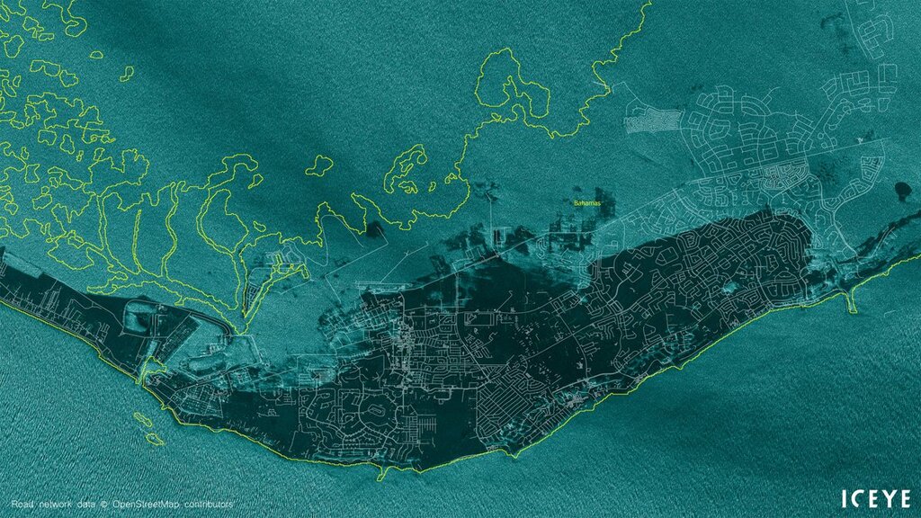
Satellite images of the Bahamas coming to light. Extremely saddened to see this. The Yellow line is where the coast line was:
ICEYE ( at iceyefi) Tweeted:
#HurricaneDorian has affected Bahamas heavily on Monday, with vast areas hit with #flooding, including the Grand Bahama International Airport, Freeport. ICEYE #SAR satellite image from 11:44AM local time. Please, stay safe! (Y: coastline. W: roads. Source: OpenStreetMap.) https://t.co/ruXau8QhKn
|
|
|
- Dorian update 12:00 27/08/2019
|
- By Matthew Cowen <matthew at virek.net>
- Date: Tue, 27 Aug 2019 12:03:34 -0400
|
| Heavy rain is always the biggest danger. A supporting wall collapsed under pressure from sodden ground during the storm:
|
|
|
- Dorian update at 11:55 27/08/2019
|
- By Matthew Cowen <matthew at virek.net>
- Date: Tue, 27 Aug 2019 11:58:37 -0400
|
| Looking at Martinique Radar it looks like the center wobbled up sharply over the southern part of Martinique. Here in the north it has become much windier since this morning and a lot more rain has bee consistently falling for a couple of hours.
|
|
|
- Dorian update at 08:45 27/08/2019
|
- By Matthew Cowen <matthew at virek.net>
- Date: Tue, 27 Aug 2019 08:49:32 -0400
|
Sustained rain but not too hard — about an inch or so in the last hour, here in the north of he island. Winds are up with a few strong gusts but nothing that’s knocking the plant pots over (my unscientific windspeed measurement 😀).
Any more reports from our friends in St Lucia?
|
|
|
- Center passing south side of St Lucia
|
- By Matthew Cowen <matthew at virek.net>
- Date: Tue, 27 Aug 2019 05:59:59 -0400
|

Martinique radar is showing a messy and distinctly non-round center passing
over the south of St Lucia this morning. The storm is struggling with what
experts believe is dry air to the north and south of the storm, this is
inflowing, making intensification difficult. Once past our islands Dorian may
intensifying there is moist air over the eastern Caribbean Sea.

--

Matthew
|
|
- Direct link to Martinique Radar
|
- By Matthew Cowen <matthew at virek.net>
- Date: Mon, 26 Aug 2019 19:02:52 -0400
|
|
|
|