|
|
- - - 2019 Hurricane Season - - -
|
- Another interesting weather day
|
- By Chris Bolt <gommier at gmail.com>
- Date: Mon, 16 Mar 2020 13:10:27 -0400
|
Like yesterday, there is hardly any breeze, again due to the low
pressure just North of Antigua (my guess).
Yesterday we spent our time on Grand Anse beach at Coconut Beach bar,
where we had a small shower. Not until I got home did I notice that
there was debris down the road and our water tank was full to
overflowing. and the pool had risen at least an inch.
Today, something similar, we have just had a heavy shower, no breeze,
yet out to sea there is sunshine. So it appears the heating of the land
is causing the moist air to rise then drop as rain over land, at least
in the South-west corner. Brighter sky towards Grand Anse.
This lack of wind is predicted to last a few days, so I would expect
something similar tomorrow, maybe?
All the best

Hogan
|
|
- Strange calm and cloudy weather with a few showers
|
- By Chris Bolt <gommier at gmail.com>
- Date: Sun, 15 Mar 2020 10:15:10 -0400
|
Hi, sometime since I posted.
There is hardly any wind today, this looks like lasting for a few days.
As I write, there is 100% cloud cover, which appears to be a combination
of low, medium and high clouds. We are having a few not too heavy
showers, which look as if they could continue this afternoon. The lack
of breeze appears to be caused by a low pressure system just North of
the Lesser Antilles.
All my best to all of you during these difficult times, where ever you are.

Hogan
|
|
- Overcast and looks like some rain coming from the East.
|
- By Chris Bolt <gommier at gmail.com>
- Date: Wed, 29 Jan 2020 10:05:37 -0400
|
Radar and satellite shows a good bit of cloud east of us, and a few
showers on radar. Also, looking out, I see some rain about 2 miles to
our East.
Hogan
|
|
- Waves at the car park
|
- By Brian P <realwedda at gmail.com>
- Date: Mon, 20 Jan 2020 11:25:06 -0400
|
|
Here are some pics
|
|
- Update
|
- By Brian P <realwedda at gmail.com>
- Date: Mon, 20 Jan 2020 11:11:50 -0400
|
|
Here is a clip of the Carenage.I understand that person's at the Ariza car park on the other side of town have to move their vehicles because of the high seas
Attachment:
3.mp4
Description: video/mp4
|
|
- Rough waves
|
- By Brian P <realwedda at gmail.com>
- Date: Mon, 20 Jan 2020 11:02:53 -0400
|
|
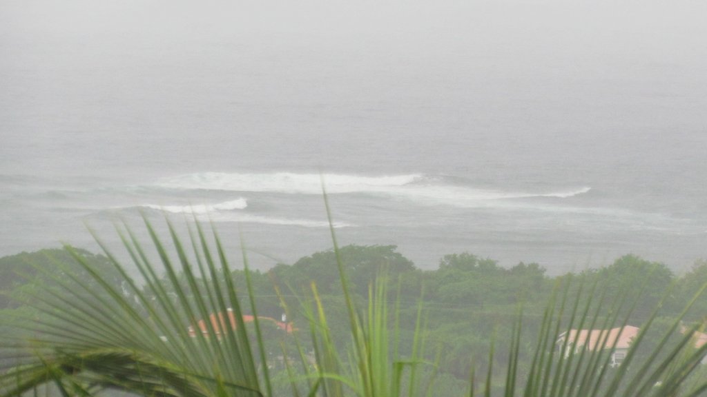
Grenada is getting its fair share of the rough waves. I have not seen the Carenage so bad in quite a while
|
|
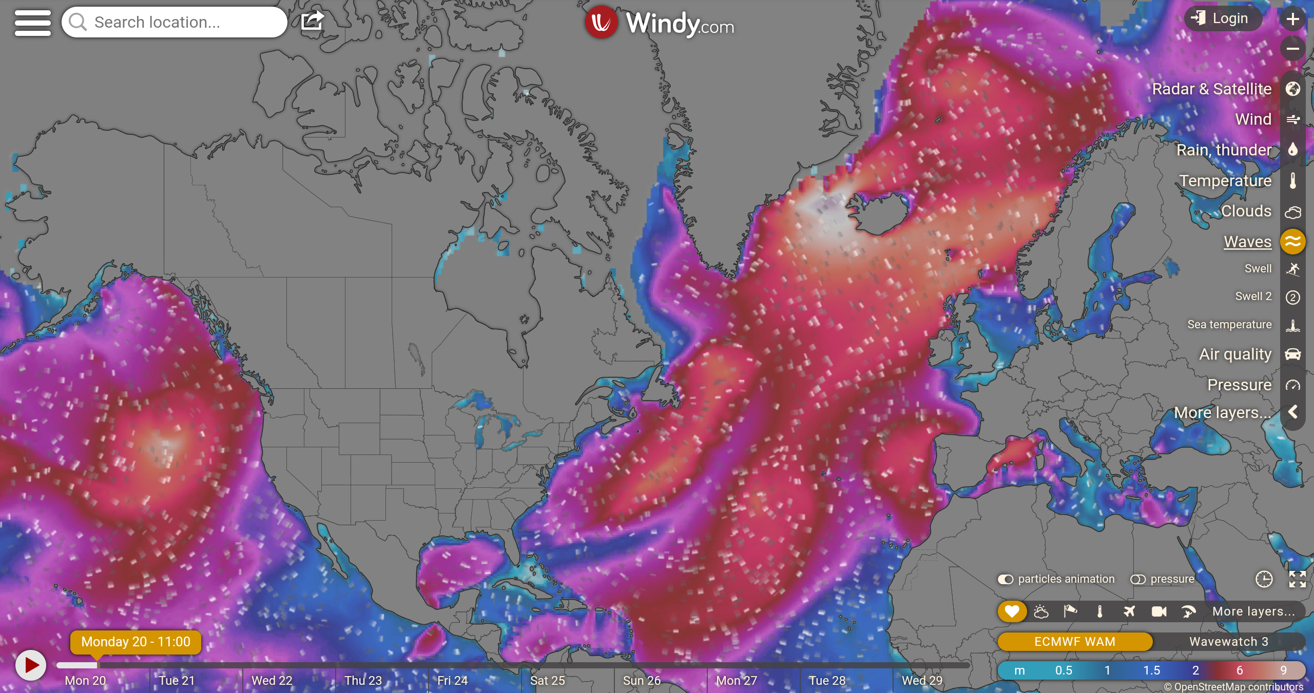
- The Swell has arrived.
|
- By Chris Bolt <gommier at gmail.com>
- Date: Mon, 20 Jan 2020 08:14:34 -0400
|
Good morning,
The swell has a arrived, a bit late. The Dive Grenada shows much larger
waves than yesterday. I have also heard from someone who lives near the
Aquarium Beach bar & restaurant that the waves are big there. They can
see the waves breaking over the reef offshore - this is unusual.
Also noticed that the Freewinds ship tried to moor at the Cruise
Terminal, but backed off and has now gone into the cargo dock, where it
is protected from the swell. There is the JJ Robinson Charity event
being held on it this evening. Waiting to hear that the event may have
moved to there?
Worth having a look at the Dive Grenada Webcam:
https://www.skylinewebcams.com/en/webcam/grenada/saint-georges/grand-anse-beach/grand-anse-beach-caribbean-sea.html
Have a nice day, look forward to seeing many of you on the Freewinds -
where ever it is.
Hogan
|
|
- What Swell?????
|
- By Chris Bolt <gommier at gmail.com>
- Date: Sun, 19 Jan 2020 19:27:50 -0400
|
Spent the afternoon at Coconut beach, expecting largish waves, but only
slightly bigger than normal there, although they were getting a bit
bigger as we left. The only other report on StormCARIB was from
Anguilla, which is getting very big surf. Let us see what tomorrow
holds, as the swell is expected to increase over night, slightly..
Still we had a pleasant afternoon at the beach and were able to have a swim.

Hogan
|
|
- Trying to find out more about the swell that is due.
|
- By Chris Bolt <gommier at gmail.com>
- Date: Sat, 18 Jan 2020 08:51:26 -0400
|
The best I can find out is that the North Atlantic Swell should start to
arrive Sunday. Various Websites are predicting greater than 3 meters
between (10-12 ft) swell, which will build up tomorrow and overnight
into Monday. The swell will be coming from the NNE and has to pass
through the other Windward Islands before getting to us.
We are planning to go to Coconut Beach tomorrow, it will be interesting
to see if the prediction is correct?
For those away from the island who would like to see if we are affected
by the swell, can I suggest you look at Dive Grenada webcam :
https://www.skylinewebcams.com/en/webcam/grenada/saint-georges/grand-anse-beach/grand-anse-beach-caribbean-sea.html

It looks lovely at the moment!

Hogan
|
|
- A large Swell to hit the Caribbean coasts ???
|
- By Chris Bolt <gommier at gmail.com>
- Date: Fri, 17 Jan 2020 22:02:38 -0400
|
Please folks, I am just passing on something that is being reported.
Whether it is true or not we will have to look into, but it does appear
that some weather in the North Atlantic could bring a very large swell
down through the Caribbean, starting on Saturday up near PR and Antigua
and then come down to our neck of the woods (or beaches) on
Sunday-Monday. The websites are predicting wave heights of more than 3
meters, from the North.
A link I use is Ventusky.com The link here is for about 20:00 on Sunday
https://www.ventusky.com/?p=14.12;-62.16;6&l=wave&t=20200120/0000 You
can adjust the date/ time yourselves.
It shows a swell coming from the North, from this direction I would
expect large breaking waves on North facing beaches, which could affect
Grand Anse (especially the Southern end), and the beach at the
Aquarium. I have picked this up from two sources now. The other is Dale
Destin - 268Weather.com
https://268weather.wordpress.com/2020/01/16/bomb-cyclone-to-push-damaging-swells-across-the-caribbean/
I stress, I am just passing on information from other websites, anyone
who has concerns should check it out themselves. Please Don't shoot the
messenger!
From Saturday onwards it might be worth looking at reports coming in
from islands further North on the Stormcarib website:
https://www.stormcarib.com/ this will give an indication of what to
expect, maybe.
Hogan
|
|
- At last the wind has died down
|
- By Chris Bolt <gommier at gmail.com>
- Date: Fri, 17 Jan 2020 07:34:45 -0400
|
Still breezy, but far less than we have had for the last few weeks.
The Martinique and Trinidad radars are now working, with hardly any
showers showing in our area. So it looks like a pleasant day with low
chance of rain showers.
Hogan
|
|
- Still windy, but roof not rattling so much.
|
- By Chris Bolt <gommier at gmail.com>
- Date: Sun, 12 Jan 2020 07:25:10 -0400
|
The wind has dropped slightly, but still strong gusts. I can see large
waves breaking over the cliffs at the end of Ft Jeudy. It looks like a
good day plenty of Sun, possibly some fast moving showers, but very breezy.
Hogan
|
|
- We are well and truly blowing into 2020
|
- By Chris Bolt <gommier at gmail.com>
- Date: Sat, 11 Jan 2020 07:55:17 -0400
|
Extremely high winds are being caused by a very 'high pressure' in the
North Atlantic. If you think it is bad here in Grenada, it is even worse
the further North you go in the Lesser Antilles.
Sorry Dave S that you chose Antigua at this time for your holiday!
It looks as if the winds will ease off about Wednesday. Until then it
will be roof rattling!
Apart from that it should remain mostly dry.

Happy new year

Hogan of Grenada
|
|
- Winter Weather
|
- By Gert van Dijken <gert at vandijken.com>
- Date: Tue, 7 Jan 2020 11:27:04 -0800
|
Greetings and Happy New Year
I had the pleasure of visiting Grenada after a 20 year hiatus. Certainly, the island has changed but in a good way. Not only is the island Styrofoam free, they are seeking to be fully plastic free. It was wonderful to see establishments using non plastic straws. There is a no kill shelter and animal welfare is in the forefront in many ways.
Weather wise, the Xmas trades were strong. Dec. 21st, we were chased off the beach due to whipping sands. As the week passed, the winds diminished. The weather overall was wonderful.
Sending positive vibes to all in PR, post earthquake. More positive vibes to The Abacao's, St. Martin and the other islands striving to overcome the incredible obstacles, post hurricanes. I pray for resilience and strength.
I love the Caribbean and appreciate this forum. I head to an island this summer to bring Buti Yoga and Mindfulness to the community and am seeking a host property to offer my wellness services (gratis). Feel free to email me with any suggestions or invites.
Ann Phelan Instagram: caribchakita and blissfilledtravel
|
|
- Look into the Western Sky this evening just after Sunset
|
- By Chris Bolt <gommier at gmail.com>
- Date: Sat, 28 Dec 2019 12:30:44 -0400
|
As there isn't much to say about the weather other than it seems to be
turning dry, I thought I would just mention.......
This won't only apply to being in Grenada, but just after Sunset this
evening, there will be a pretty sight of the crescent Moon and just
above it a very bright dot. This will be visible almost everywhere on
Earth, although the far East and Australia etc will see the Moon above
the bright dot. For those in Grenada, or other places in the Caribbean
that believe the bright dot, which has been visible for several weeks,
is a US satellite 'spying on them' as I have often heard in Grenada, it
is not, it is Venus, which is a planet nearer to the Sun than us. For
that reason we only ever see it either just before Sunrise or, as is the
case at the moment, just after Sunset. Enjoy the view this evening when
the Sun has gone, but the sky is still glowing.
May I take this opportunity to wish all who look at my weather blog, and
StormCARIB a very happy 2020.
Hogan of Grenada
|
|
- Been away for a while, but now back
|
- By Chris Bolt <gommier at gmail.com>
- Date: Fri, 13 Dec 2019 08:33:22 -0400
|
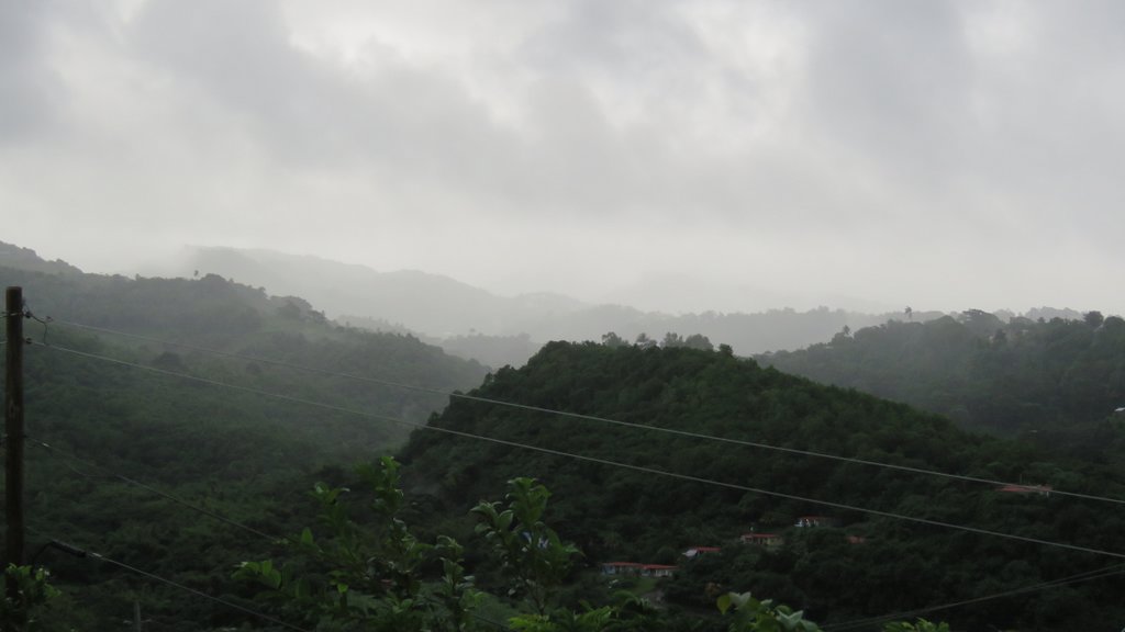
Hi all,
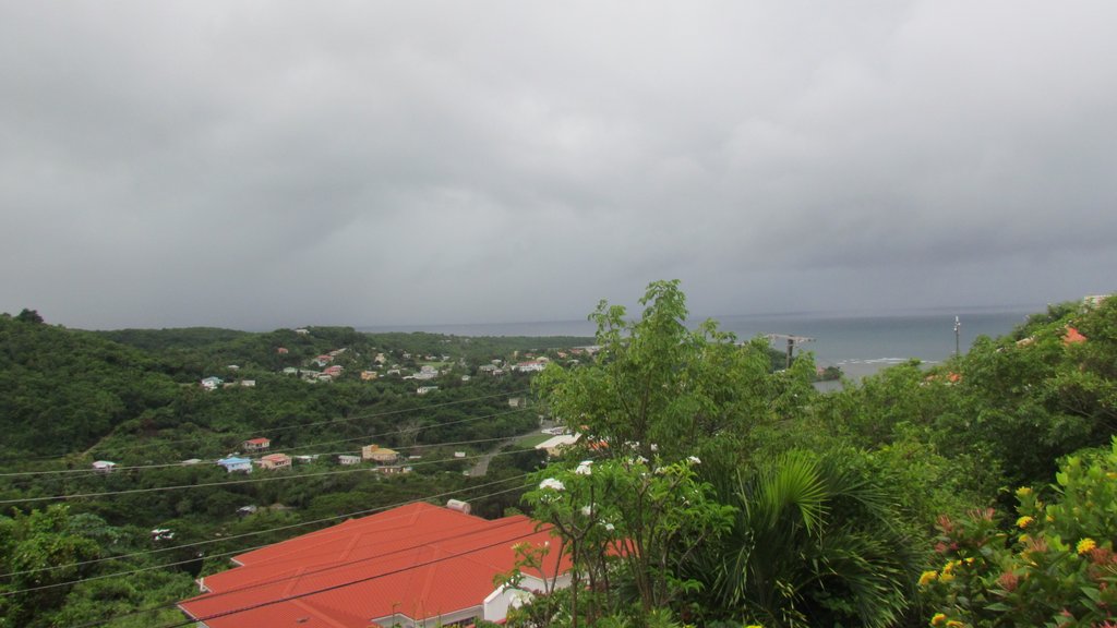
I am back in Grenada. I seem to have come back to some grim weather. It
seemed to be getting brighter this morning, but now having to put lights
on. Photo of mountains and cloud. Now raining heavily again.
The Trinidad radar does not seem to be working. But the Martinique radar
shows numerous showers around.
Regardless of the weather, it is nice to be back.

Hogan

You have been sent 1 picture.

IMG_0920.JPG

These pictures were sent with Picasa, from Google.
Try it out here: http://picasa.google.com/
|
|
- Did anyone feel an earthquake yesterday evening about 8:10pm?
|
- By Chris Bolt <gommier at gmail.com>
- Date: Tue, 19 Nov 2019 08:15:36 +0000
|
There was a magnitude earthquake between Grenada and Barbados. It was a
magnitude 4,7 (not very strong), at a depth of 57km. Did anyone in
Barbados or Grenada feel it? It was at 20:10 (8.10pm).
Hogan
|
|
- Tropical wave
|
- By Brian P <realwedda at gmail.com>
- Date: Tue, 5 Nov 2019 14:57:15 -0400
|
|
A tropical wave is approaching the island. Seems as if we may have a few showers. Persons on low lying areas should always take precaution. You never know what will happen with these waves.
|
|
- The weather system off to our East...
|
- By Chris Bolt <gommier at gmail.com>
- Date: Tue, 15 Oct 2019 14:34:20 -0400
|
The area of concern in this morning's post, is now down to 0% chance of
developing in next 2 and 5 days (per NHC).
Hogan
|
|
- Tropical Depression 15 has developed Just SE of Cabo Verdes
|
- By Chris Bolt <gommier at gmail.com>
- Date: Tue, 15 Oct 2019 07:01:16 -0400
|
This system will pass over the Cabo Verdes into the North Atlantic.
Meanwhile the system off to our East, briefly went to a 20% chance of
developing (last night), but has dropped back to 10% in next 48 hours.
It looks as if it will track to the North of Barbados (NHC 5 day).
There are only a few blips on the weather radar as the trailing edge of
the tropical wave moves out to the West.
There are some areas of high cloud and there is a small shower passing
to my SE. It is hazy.
Hogan
|
|
- Just as it is meant to be getting quieter!
|
- By Chris Bolt <gommier at gmail.com>
- Date: Mon, 14 Oct 2019 06:29:08 -0400
|
The Atlantic is starting to buzz. There are now 4 areas of storms or
possible storms.
Melissa in the North Atlantic and of no worry to us. Another area just
off the East coast of Central America with a small chance of developing
as it moves over the Yucatan. Over the other side of the Atlantic just
coming off Africa is a 70% chance of developing over next 2 days, but
likely to turn North into the Cabo Verdes. And lastly an area just this
side of mid Atlantic is an area of thunder storms which has a 10% chance
of developing by Wednesday as it reaches The Windwards.
This morning there is hardy any breeze. It is mostly sunny with only a
few clouds. A small shower can be seen out at sea to the South. The
radar has a few blips to our East. The synoptic chart shows a weak
tropical wave passing through, so there is an increased chance of
showers later.
Have a nice day.
|
|
- A weather system is coming off of Africa.
|
- By Chris Bolt <gommier at gmail.com>
- Date: Sat, 12 Oct 2019 07:00:26 -0400
|
This is late in the year for tropical cyclones to form in that area. It
is not expected to develop - only 30% chance in 5 days. Also it is
expected to travel in a North-Westerly direction, and not expected to
survive upper level winds.
Today looks a nice day (hope so as we are going round the island with
friends). Only a couple of small blips on the radar and very light
winds. I am guessing that showers could develop as the land heats up,
especially over hills. Much less high cloud today, so far, although
there is still the upper level Westerly wind (but not as strong as
yesterday) also storms just north of the Venezuela/Columbia border area.
Found that Dive Grenada Webcam has a 24 hour time lapse of yesterday,
not sure if this link will work, but the high cloud I mentioned was
visible. The rain showers they had, we didn't, and we are only about 4
miles away, as the crow (rain clouds) fly! :
https://www.skylinewebcams.com/en/webcam/grenada/saint-georges/grand-anse-beach/grand-anse-beach-caribbean-sea.html?timelapse=1
Currently there are a few fluffy clouds around, with the mountains
topped with clouds.
Have a nice Saturday.

Hogan
|
|
- Fwd: Much nicer morning.
|
- By Chris Bolt <gommier at gmail.com>
- Date: Fri, 11 Oct 2019 08:06:32 -0400
|
There is some high hazy cloud, and looking towards the East-South-east
there a re a few high Cumulus clouds. They are visible on the radar just
North of Tobago and appear to be moving in a NE direction, most look as
if they will pass to the North of Grenada. But they also appear to be
breaking up. So maybe we will get the odd shower later this morning???
What we are likely to see is an increase in the high cloud which is
sweeping in from the West (yes West). This cloud seems to be coming from
storms in the NW of Venezuela where the high altitude jet stream is
ripping the tops off the clouds. This band of cloud appears thicker
towards St Vincent and St Lucia. The different direction of high and low
cloud can be seen clearly on time-lapse photos from Barbados website:
http://www.barbadosweather.org/VideoStore/WxCam_displayer.php?Instrument=Camera&Period=20%20min&Title=Cam%201%20NNE
The rest of our part of the Atlantic looks OK, apart from two tropical
waves, one in the East and one midway across the Atlantic.
Have a nice day

Hogan
|
|
- Much better morning than yesterday.
|
- By Chris Bolt <gommier at gmail.com>
- Date: Wed, 9 Oct 2019 07:50:59 -0400
|
There are showers on the radar, one of which we just had, but most look
as if they will pass south of us. Our part of the Atlantic is free of
any areas of concern.
Hazy nice breeze. Looking East - The Sun is shining through various
layers of clouds with some larger cumulus clouds pushing through those
layers. Putting this together with the radar, it looks as if we could
get one of the showers (mentioned above) fairly soon.
Have a nice day.

Hogan
|
|
- A lovely Sunset after a very wet day.
|
- By Chris Bolt <gommier at gmail.com>
- Date: Tue, 8 Oct 2019 18:07:30 -0400
|
Hogan

You have been sent 1 picture.

IMG_0327.JPG

These pictures were sent with Picasa, from Google.
Try it out here: http://picasa.google.com/

|
|
- Horrible morning
|
- By Chris Bolt <gommier at gmail.com>
- Date: Tue, 8 Oct 2019 08:00:24 -0400
|
Rained a lot during the night and more rain as I write. 100% overcast
with drizzly rain. Some strong gusts of wind.
The radar shows an area of cloud/rain Between just South of Barbados and
Tobago. The satellite images show a large area of clouds bubbling up as
part of what is shown on the radar and further East. But it does
coincide with the Inter Tropical Convergence Zone (ITCZ) as shown on the
synoptic chart. As such, may not move in our direction - big guess!
As I finish, the wind has dropped and the rain also. Still completely
overcast with high cloud. Looks like a day of cloud and probably shower,
maybe longer periods of rain.
Back to decorating!

Hogan
|
|
- Plenty of heavy rain over night.
|
- By Chris Bolt <gommier at gmail.com>
- Date: Mon, 7 Oct 2019 07:40:24 -0400
|
Yesterday was very hazy. But no rain here (Westerhall).
But overnight we had several heavy showers. Looking at the radar we have
more to come. There is a tropical wave passing through our area.
Nothing to report in the Atlantic, except another tropical wave
following this one (mid Atlantic).
Hogan
|
|
- Woke up to a heavy shower.
|
- By Chris Bolt <gommier at gmail.com>
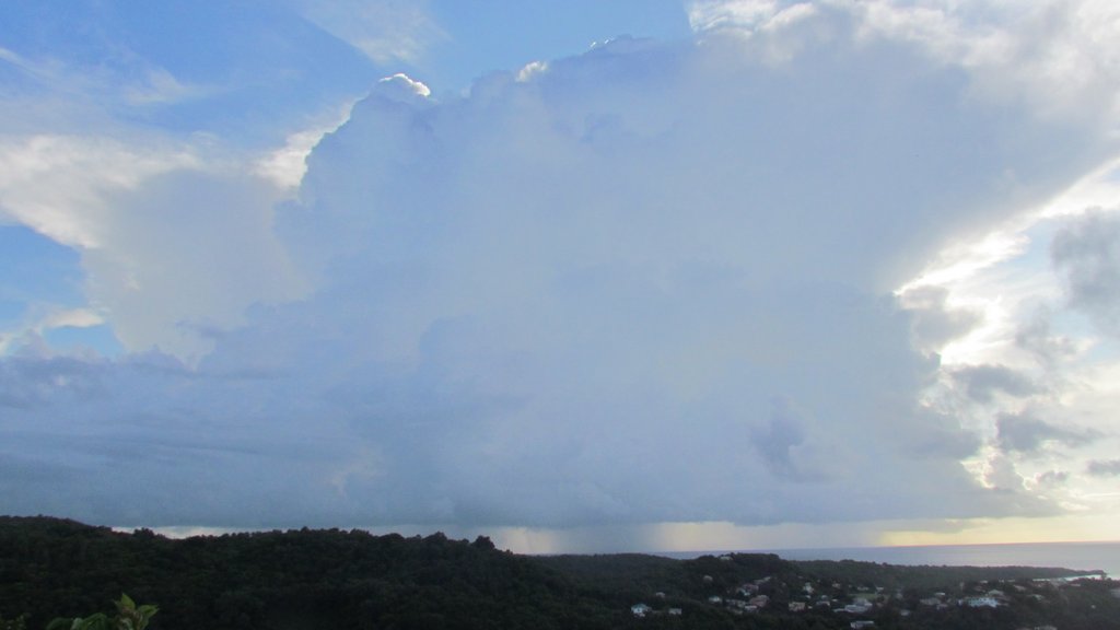
- Date: Sat, 5 Oct 2019 07:12:10 -0400
|
The Atlantic is quiet, at the moment, no tropical storms anywhere.
Looking out to our East I see some large clouds creeping in this
direction. The radar confirms that there are scattered showers within
the triangle Grenada, Barbados, Tobago and they are moving in our
general direction. So chances of rain are a bit hit and miss. Although
the one in the photo looks like it will be a hit!
Have a nice day.

Hogan

You have been sent 1 picture.

IMG_0325.JPG

These pictures were sent with Picasa, from Google.
Try it out here: http://picasa.google.com/
|
|
- Lightning, thunder and some heavy rain over night.
|
- By Chris Bolt <gommier at gmail.com>
- Date: Thu, 3 Oct 2019 07:06:45 -0400
|
The leading edge of a tropical wave passed through, bringing heavy rain
for a while, with some lightning and thunder. That has passed, but the
radar does show several showers still around. Looking out I can see rain
to the East, SE and South. High overcast cloud, a bit of Sun shining
through the clouds to the East. And I just heard another rumble of
thunder from the South-east.
It looks like a day of showers. Some websites show plenty of cloud,
especially high cloud.
Lorenzo has disappeared from the NHC, but looking at the UK BBC weather,
I see that the UK is about to get the remnants of what was hurricane
Lorenzo, later today and tomorrow.
A last look out and it does look as if the shower to our East might
scrape through the South of Grenada in the next half hour.
Hogan
|
|
- Another mostly dry couple of days?
|
- By Chris Bolt <gommier at gmail.com>
- Date: Tue, 1 Oct 2019 06:53:33 -0400
|
It looks like yet more of the same. The radar shows just a few small
showers passing Grenada to the South, although I can't see any from
here. There is some high wispy clouds, making the sun hazy. There are
clouds over the mountains (not unusual). A slight Easterly breeze.
There are a couple of weak tropical waves crossing the Atlantic, but no
sign, as yet, of anything significant.
Lorenzo, still a very large hurricane is about to affect the
North-western Azores and is heading towards NW Scotland, although will
have, hopefully, reduced to just a storm when it gets there (Thursday?).
One website has it hitting the UK further South.
Now, back to decorating!

Have a nice day

Hogan
|
|
- Some heavy rain.
|
- By Chris Bolt <gommier at gmail.com>
- Date: Mon, 30 Sep 2019 12:11:30 -0400
|
Rain has just popped up from nowhere. Radar didn't show it coming - but
it is welcome.
Lorenzo is mid Atlantic 30N 42.6W and heading in the direction just
north of Scotland (at the moment).
Hogan
|
|
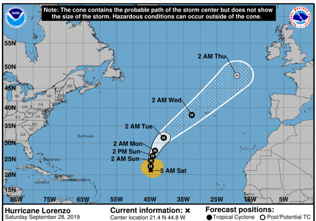
- Hurricane Lorenzo heading in the direction of the UK?
|
- By Chris Bolt <gommier at gmail.com>
- Date: Sat, 28 Sep 2019 10:42:20 -0400
|
Good morning,
The only weather system left in the Atlantic is hurricane Lorenzo
(current location 21.4N 44.8W). The NHC chart shows it heading in the
direction of the UK.
There is a tropical wave coming across the Atlantic, below and to the
East of Lorenzo
Here it is a fine day, just a few showers in the area.

Hogan


You have been sent 1 picture.

Fullscreen capture 28092019 103357.jpg

These pictures were sent with Picasa, from Google.
Try it out here: http://picasa.google.com/
|
|
- Hot! Hot!Hot!
|
- By Brian P <realwedda at gmail.com>
- Date: Fri, 27 Sep 2019 17:41:09 -0400
|
It has been really hot here for the past couple of days. A tropical wave is approaching but it really has little moisture associated with it due to the harsh conditions out there. Lots of dry air around. Seems as if Barbados will get most of the little moisture associated with this wave. Let's hope we get some tonight too.
|
|
- Just a brief update
|
- By Chris Bolt <gommier at gmail.com>
- Date: Wed, 25 Sep 2019 15:56:18 -0400
|
Lorenzo is now a hurricane over the other side of the Atlantic. It is
following forecast path up into the Atlantic. Current position is 14.1N
35.7W.
Hogan
|
|
- Karen heading for Puerto Rico
|
- By Chris Bolt <gommier at gmail.com>
- Date: Tue, 24 Sep 2019 10:45:54 -0400
|
Karen is still only 1 mph over Tropical Storm status and heading for
Puerto Rico. It looks like they could get plenty of rain.
Across the Atlantic TD13 has become Tropical Storm Lorenzo. The last
reported position is 12N 28W (well over 2000 miles due East of us. But
it is expected to take a N-Westerly direction, into the Atlantic.
Here, the weather has returned to normal. A slight breeze from the SE.
The Sun is shining. Clouds over the hills, but mostly blue sky out to sea.
Have a nice day.

Hogan
|
|
- After TS Karen
|
- By Chris Bolt <gommier at gmail.com>
- Date: Mon, 23 Sep 2019 09:43:02 -0400
|
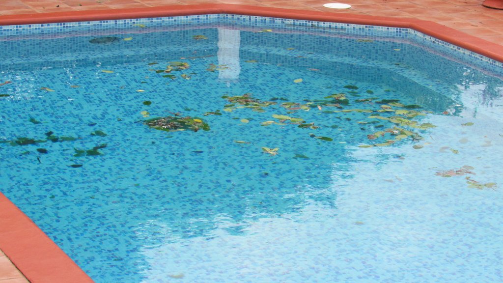
TS Karen has gone by, supposedly between Carriacou and Grenada according
to the NHC, although reports from near Sauteurs say the weather they had
was nowhere near as bad as down South. The only effect Karen had on us
was leaves in the pool. But there were reports of severe flooding,
including the golf course being flooded and someone floating into a
ditch as they tried to drive through a flooded road. Trinidad had some
severe flooding. We had some strong winds, but nothing too bad. The
highest wind speed showing on the airport graph was 26mph. Tropical
Storm speed starts at 39mph. Maybe Carriacou, apparently being on the
North of 'the storm' had TS winds? Is there anyone there who has a
weather station who can tell us what sustained speeds were recorded? The
lowest pressure reported at Maurice Bishop airport was nowhere near what
the NHC said it was as it passed through the Grenada area. I see a
report from Bequia had some strong gusts.
Now let's leave Karen behind us (hope all OK for PR), and look East.
Already the tropical wave, that has come off of Africa, is a Tropical
Depression (Thirteen). It is approximately 12N 23W ( Just South of Gabo
Verdes). Although at our latitude, the predicted path takes it up
through the Atlantic. I shall keep an eye on it.
No rain here overnight, just a southerly stiff breeze. This morning we
still have the breeze from SSE. The breeze should drop off a bit as the
day goes on and the wind turns more towards the SE to ESE.
The radar shows very few blips between us and Tobago. The Sun is
shining, just some wispy high cloud and a 'street' of clouds between us
and Barbados, but they are moving north, they appear clearly on the radar.
temperature is 29C (84F) at 09:00  already better than at anytime yesterday.

Hope you have a nice day.

Hogan

You have been sent 1 picture.

IMG_0247.JPG

These pictures were sent with Picasa, from Google.
Try it out here: http://picasa.google.com/
|
|
- Large waves breaking on the reef.
|
- By Chris Bolt <gommier at gmail.com>
- Date: Sun, 22 Sep 2019 13:18:08 -0400
|
The heavy rain has stopped (for now). The strong gusty westerly winds
have also stopped, just back to a gentle westerly breeze. Still
completely overcast. We have just had about 2 inches of rain in half an
hour.
The photo shows easterly swell breaking over the reef. Possibly an
indication of the stronger Easterly winds that have been chasing Karen.
My guess is that Southerly, followed later by South-Easterly winds will
pick up this afternoon/evening, hopefully not too much. Probably in the
20's mph, maybe higher gusts - If that is the case then not too bad.
As I am about to post this, the Westerly breeze is picking up a bit,
latest from airport is from West at 20mph. We have moved all light
furniture away from the expected wind direction.
Had text to say NAWASA turned off all water systems from 12:00 - also
NaDMA have opened shelters.
We are now entering the windier part of this system - all the best.
Listen to the official reports.
Hogan


You have been sent 1 picture.

IMG_0243.JPG

These pictures were sent with Picasa, from Google.
Try it out here: http://picasa.google.com/
|
|
- KAREN
|
- By Brian P <realwedda at gmail.com>
- Date: Sun, 22 Sep 2019 09:24:31 -0700
|
|
Well it's raining in my neck of the woods. No wind to speak about so far. Water systems have been shut down as a precautionary measure.
Let's see what Karen brings. So far so good.
|
|
- Karen
|
- By "Richard and Jenita" <richardandjenita at spiceisle.com>
- Date: Sun, 22 Sep 2019 10:29:00 -0400
|
Sky is dark with not much wind here in Hope City. A little drizzle but haven’t heard the thunder that Chris mentioned probably because we are a little further north. Not by much though. Just waiting........ |
|
|
- Dark sky to the East
|
- By Chris Bolt <gommier at gmail.com>
- Date: Sun, 22 Sep 2019 10:16:14 -0400
|
Still getting Thunder, although it has slowed, and the sky is pretty
dark in the East and South. The westerly breeze has stopped. Now it is
raining.
Hogan

You have been sent 1 picture.

IMG_0242.JPG

These pictures were sent with Picasa, from Google.
Try it out here: http://picasa.google.com/
|
|
- Karen update - just hearing some distant Thunder.
|
- By Chris Bolt <gommier at gmail.com>
- Date: Sun, 22 Sep 2019 09:16:34 -0400
|
Good morning,
99L is now a named storm, just as it approaches the islands. We
now have Karen on our doorstep.
Plenty of rain over night. Now (07:30) we have complete
overcast sky, and a slight breeze from the NNW. The
latest position from NHC at 02:00 local time was 11.9N
60.2W which was about 100 miles East of us.
Looking at the current radar, the rain showers seem to be
circulating round a point between Tobago and Grenada.
And we appear to be in an area with little rain (for
now). See:
http://www.barbadosweather.org
Now, if the NHC report is correct, and Karen passes directly
through Grenada, then it looks like we can expect the
strongest winds after the storm passes us. And they will
come from the South, before turning later to the SE.
Looking out it is overcast, mostly high cloud, with a very
hazy Sun trying to show through. There is a slight North
Westerly breeze, all the boats, at anchor, pointing in
that direction. There seems to be a bank of low cloud
(maybe rain) in the direction of ST George and Point Saline,
but just high cloud here (Westerhall) and to the East. ( I have just
checked the pressure at the airport, this hasn't changed for 3 hours,
so no rapid drop). It does feel that we are in or near the middle
of Karen.
Outlook for today - windy (S or SE), overcast, rain.

All the best for today.

Hogan
|
|
|
- Just heard some thunder
|
- By Chris Bolt <gommier at gmail.com>
- Date: Sun, 22 Sep 2019 09:12:05 -0400
|
Wind dropping, but still from NW.
|
|
- 99L jumped from being disorganised, bypassing a Tropical Depression, to Tropical Storm Karen.
|
- By Chris Bolt <gommier at gmail.com>
- Date: Sun, 22 Sep 2019 07:42:21 -0400
|
Good morning,
99L is now a named storm, just as it approaches the islands. We now have
Karen on our doorstep.
Plenty of rain over night. Now (07:30) we have complete overcast sky,
and a slight breeze from the NNW. The latest position from NHC at 02:00
local time was 11.9N 60.2W which was about 100 miles East of us.
Looking at the current radar, the rain showers seem to be circulating
round a point between Tobago and Grenada. And we appear to be in an area
with little rain (for now). See:
http://www.barbadosweather.org
Now, if the NHC report is correct, and Karen passes directly through
Grenada, then it looks like we can expect the strongest winds after the
storm passes us. And they will come from the South, before turning
later to the SE.
Looking out it is overcast, mostly high cloud, with a very hazy Sun
trying to show through. There is a slight North Westerly breeze, all the
boats, at anchor, pointing in that direction. There seems to be a bank
of low cloud (maybe rain) in the direction of ST George and Point
Saline, but just high cloud here (Westerhall) and to the East. ( I have
just checked the pressure at the airport, this hasn't changed for 3
hours, so no rapid drop). It does feel that we are in or near the
middle of Karen.
Outlook for today - windy (S or SE), overcast, rain.

All the best for today.

Hogan
|
|
- Many people have been asking me about the weather system expected tomorrow.
|
- By Chris Bolt <gommier at gmail.com>
- Date: Sat, 21 Sep 2019 16:50:02 -0400
|
|
The answer is, I don't know, or I am reluctant to say. The NHC
have stated :-
A NOAA hurricane hunter aircraft has been investigating a tropical
wave located several hundred miles east of the Windward Islands this
afternoon. The aircraft found evidence of a sharp surface trough but
confirmed that a well-defined circulation has not formed.
The satellite images give the impression the system has become
less organised. The NHC also no longer have a Lat/Lon for it's
location. The synoptic chart only shows a tropical wave and no
longer shows a 'Low' in the tropical wave. They are giving it a
50% chance of developing in 48 hours (we are expecting it in 24
hours, or so). So it does look as if we could get rain, possibly
some very heavy, with gusty winds. But it does look unlikely we
will get a tropical storm, but possibly a tropical depression. But
please do not take actions based on my guesswork. Always take
advice from the official weather forecast.
Also, there seems to be a text going round, called the Equinox
phenomenon and that it will affect us over the next few day. It
states that the Sun is overhead at the Equator. This is true, But
the rest of the text telling people that because of this you
should stay indoors between 11am and 4pm, to keep the pets
indoors, temperatures could reach 40C, and have buckets of water
in the room and to drink 3 litres of water. Most of this text is
absolute nonsense (apart from obvious things that should apply all
the time). For the record, the Sun was directly overhead of
Grenada at midday about a month ago, and this did not affect our
normal weather. So if you do get this text, my suggestion is to
ignore it and do not pass it on. Thank to the person who told me
about it.
More later if the weather changes.
Hogan
|
|
|
- 99L about 600 miles Just East-South-East of us.
|
- By Chris Bolt <gommier at gmail.com>
- Date: Sat, 21 Sep 2019 07:11:29 -0400
|
|
Good Morning,
Sorry about the East/West mistake yesterday. 99L is definitely
out to our East and now is about just under 600 miles from us. The
latest position from NHC was 10N 51.7W and moving West or
West-Northwest at about 15-20 MPH, at 02:00 EDT (wish they would
use UTC), anyway that was a few hours ago. Most of the tracks are
showing a path that goes North of Grenada and South of Barbados,
most have it going through St Vincent, but a couple have it
passing South of Grenada.
Below is a quote from NHC re 99L at 02:00 EDT:-
"a tropical depression could form on Sunday
or early next week while the system moves quickly westward to
west-northwestward at 15 to 20 mph, crossing the Windward Islands on
Sunday....... Regardless of development, heavy rainfall is possible
over much of the Lesser Antilles over the weekend, and interests on
those islands and Puerto Rico should monitor the progress of this
disturbance".

The radar and satellite images show only a couple of showers in our
region. The latest satellite shows the first of the big clouds from
99L still about 400 miles away.  We had some rain over night.  Looking
out, I can see a couple of showers passing the South of us. It is hazy
and no wind, quite a bit of broken clouds, the Sun is
shining. Temperature is 27C at 10:00 UTC (06:00 in Grenada).

Have a good day, I will do an update later today, if there is any
change to 99L.

Hogan
|
|
|
- 99L two days away - correction
|
- By Chris Bolt <gommier at gmail.com>
- Date: Fri, 20 Sep 2019 23:10:42 -0400
|
|
Thanks Jurgen for spotting it.
The tropical wave is now 48 hours away and has been designated
99L. It's current position is 10.2N 49.5W That is 830miles to our
East (Not West) and travelling West at about 20mph. So
that means it will be here about Sunday. NHC have it as 30% chance
of developing into a cyclone in that time. By that I am assuming
that can mean Tropical Depression. There are some model tracks for
99L showing a course just North of Grenada.
Let us see what tomorrow brings morning brings.
Hurricane Jerry is about 100 miles North of Antigua and heading
into the Atlantic. Bermuda is in it's path.
Hogan
|
|
|
- 99L two days away
|
- By Chris Bolt <gommier at gmail.com>
- Date: Fri, 20 Sep 2019 18:29:29 -0400
|
The tropical wave is now 48 hours away and has been designated 99L. It's
current position is 10.2N 49.5W That is 830miles to our West and
travelling West at about 20mph. So that means it will be here about
Sunday. NHC have it as 30% chance of developing into a cyclone in that
time. By that I am assuming that can mean Tropical Depression. There are
some model tracks for 99L showing a course just North of Grenada.
Let us see what tomorrow brings morning brings.
Hurricane Jerry is about 100 miles North of Antigua and heading into the
Atlantic. Bermuda is in it's path.
Hogan
|
|
- Did I say no sign of rain yet????
|
- By Chris Bolt <gommier at gmail.com>
- Date: Fri, 20 Sep 2019 09:25:19 -0400
|
|
Yet again - wrong, well at least
here in Westerhall!!!
------------------------------------------------------------------------------------
Hurricane Jerry is at 18.5N 59.6W and looks like passing NE of
the Leewards. But tracks indicate a turn towards Bermuda.
There is a tropical wave about 700 miles East of us that has a
30% chance of developing in the next 5 days. Although
(hopefully) not too strong, we should get the effects of it
Sunday-Tuesday. The cone of probability is through the Windward
islands, at the moment. Comparing today's satellite images with
this mornings, it does seem to be getting more organised (far
more clouds and clumping together).
A little bit more worrying, is a tropical wave just about to
come off of Africa. This is already showing a 70% (in 5 days) of
developing South of the Gabo Verdes. More on this tomorrow.
View outside shows some clouds, including a long 'street'
stretching from about Point Saline, to our West, out to the East
of here, but just out to sea. Some parts of it look quite dark,
but no sign of rain, as yet.
The radar does show some showers just North of Tobago, they are
moving in our direction, but appear to be breaking up. It looks
like a pleasant day ahead?
have a nice day
Hogan

|
|
|
- Jerry looks like missing the Caribbean - but
|
- By Chris Bolt <gommier at gmail.com>
- Date: Fri, 20 Sep 2019 08:30:18 -0400
|
|
Hurricane Jerry is at 18.5N 59.6W and looks like passing NE of
the Leewards. But tracks indicate a turn towards Bermuda.
There is a tropical wave about 700 miles East of us that has a
30% chance of developing in the next 5 days. Although (hopefully)
not too strong, we should get the effects of it Sunday-Tuesday.
The cone of probability is through the Windward islands, at the
moment. Comparing today's satellite images with this mornings, it
does seem to be getting more organised (far more clouds and
clumping together).
A little bit more worrying, is a tropical wave just about to come
off of Africa. This is already showing a 70% (in 5 days) of
developing South of the Gabo Verdes. More on this tomorrow.
View outside shows some clouds, including a long 'street'
stretching from about Point Saline, to our West, out to the East
of here, but just out to sea. Some parts of it look quite dark,
but no sign of rain, as yet.
The radar does show some showers just North of Tobago, they are
moving in our direction, but appear to be breaking up. It looks
like a pleasant day ahead?
have a nice day
Hogan
|
|
Older reports from Grenada have been moved to another page.
|
