|
|
|
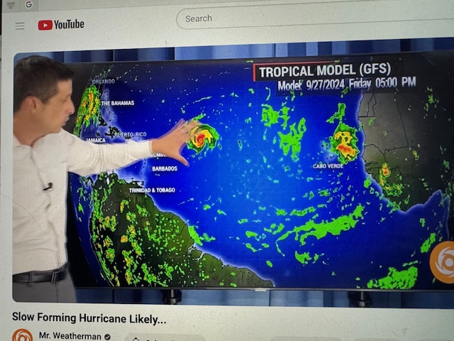
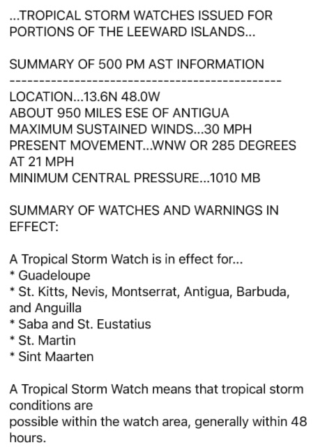
- Watching to the East
|
- By Martha Gilkes <gilkesm at me.com>
- Date: Fri, 20 Sep 2024 20:51:28 -0400
|
Possibly forming over next week ! Stay alert !
Sent from my iPhone
|
|
- Antigua stormy weather
|
- By Martha Gilkes <gilkesm at me.com>
- Date: Fri, 13 Sep 2024 03:42:28 -0400
|
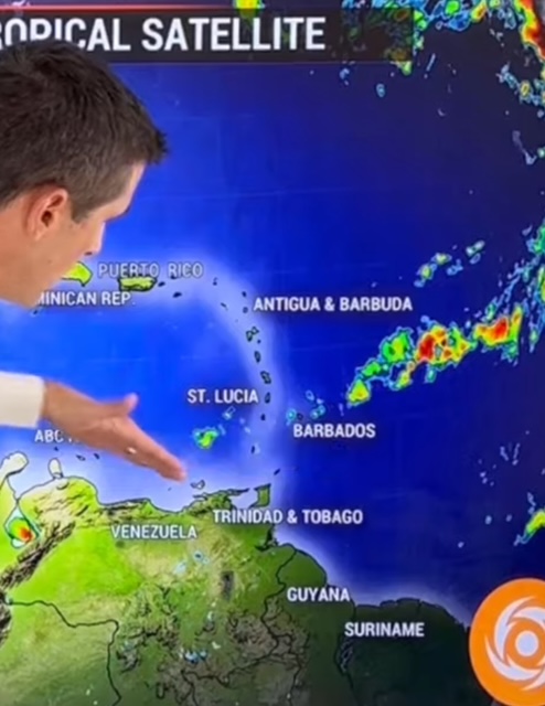
We have this weather on top of us now     Lots of thunderstorms and lightning!

This is shared by Steve on Antigua weather  site
I have been watching the small but potent area of deep convection as it
approached us.........Had conditions been different, Invest 94 would likely
have developed to be a tropical cyclone before it reached us, but fortunately
that seems not to be the case, and the NHC is classifying this as a surface
trough of low pressure.
Sent from my iPhone
|
|
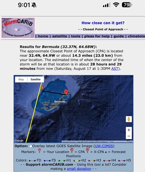
- Hurricane Ernesto
|
- By Martha Gilkes <gilkesm at me.com>
- Date: Fri, 16 Aug 2024 09:05:08 -0400
|
HAVING JUST GONE THRE ERNESTO as A STORM… very concerned with this path which seems to be OVER BERMUDA as it is now a strong hurricane. Thinking of my “ Bermuda Family” who also have a house next door to me here in ANTIGUA …. and pray for thier safety and that lives will be spared on Bermuda. They should be getting the effects tomorrow SATURDAY from this tool on GERTS www.stormcarib.com site Thank you GERT FOR YOUR INFO YOU PROVIDE US with your site.
 Sent from my iPhone |
|
|
- Antigua and Barbuda Update 4:40 PM
|
- By Linda Toth <ltothtravels at gmail.com>
- Date: Tue, 13 Aug 2024 16:40:14 -0400
|
Adios Ernesto!
Just as quickly as Ernesto arrived, he left. The sun is trying to peek out once again and all reports are indicating that we are in the clear. Patio furniture and plants are back on the deck and sandbags removed. Flights are back on track and the airport has re-opened.
We were very fortunate with this Tropical Storm. Ernesto has moved north of us and will soon become a hurricane.
Again, time has been utilized well with preparing residents with instructions on securing their homes and opening up shelters for the less fortunate. Wishing everyone in the Virgin Islands and Puerto Rico safety as they brace for Ernesto's impact.
Linda Toth, Jolly Harbour, Antigua and Barbuda 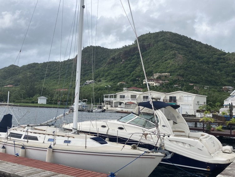
|
|
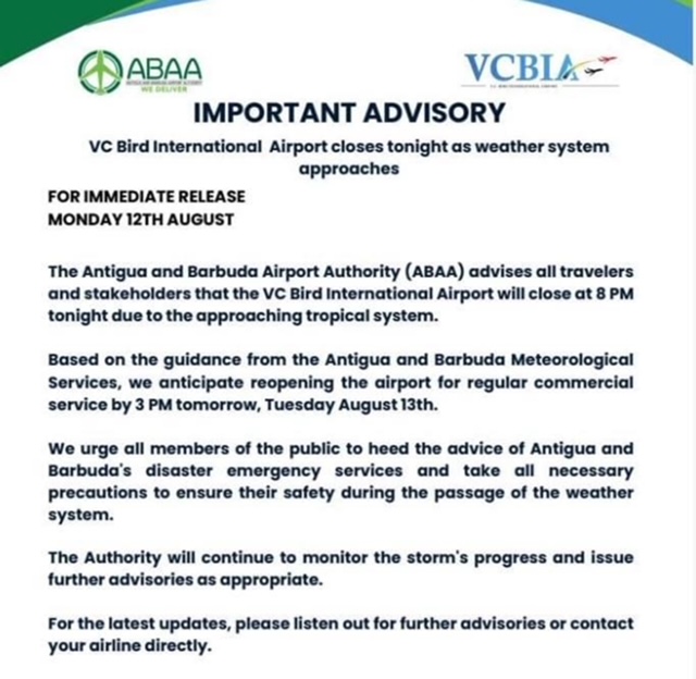
- 9:15 AM Update from Jolly Harbour Antigua and Barbuda
|
- By Linda Toth <ltothtravels at gmail.com>
- Date: Tue, 13 Aug 2024 09:31:13 -0400
|
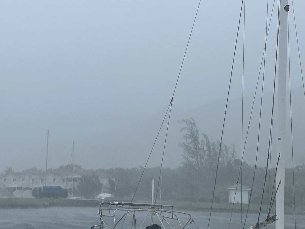
Tropical Storm Ernesto is upon us now. Our airport here, VC Bird, wisely closed last night and will re-open again today at 3 pm, weather permitting. As the storm approached we lost power at 8:45 am and it was just restored now at 9:15 am, as I am writing this report.
The air temperature has dropped several degrees celsius down to 26 and the wind is gusting at 48 km/hour. With a good view point from our deck on the harbour I can see neighbours have prudently removed plants, patio furniture etc from their decks and hurricane shutters are up.
At times visibility is reduced and when I look to the right I can no longer see the iconic Sleeping Indian hills, a popular landmark here in Jolly Harbour.
We know from watching current and detailed reports that we will be experiencing more weather like this over the next few hours. Following the protocols that were provided to us will keep us safe and dry. Linda Toth
Attachment:
454857153_7152657894837221_4284568417941008906_n.mp4
Description: MP4 movie
|
|
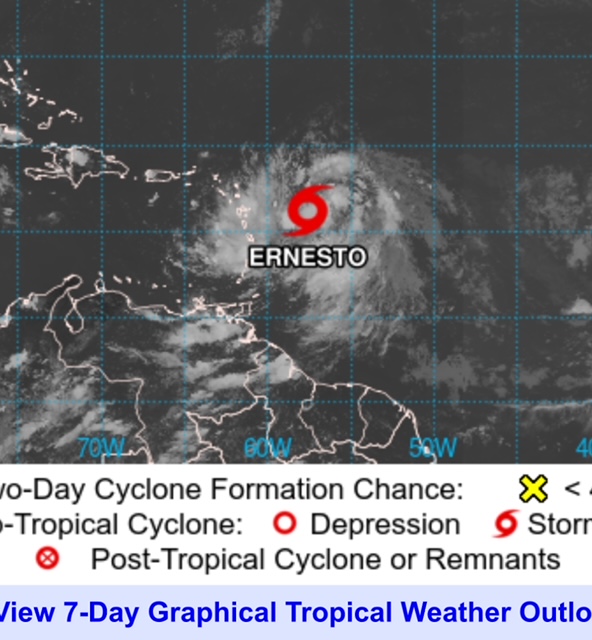
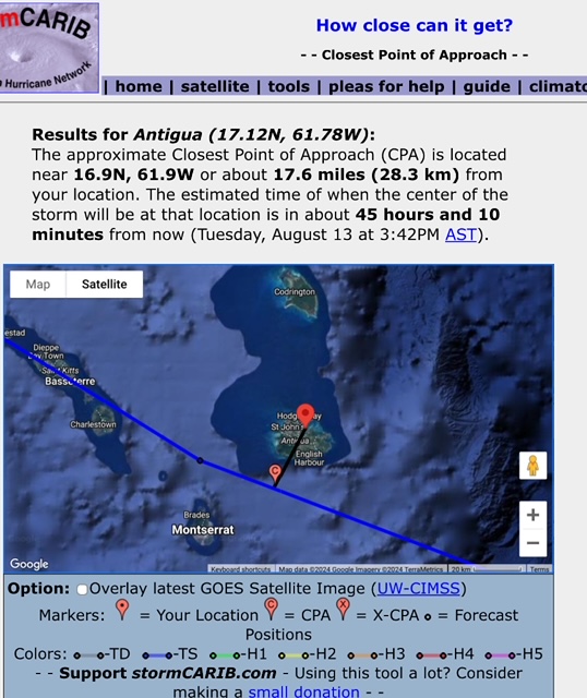
- TROPICAL STORM ERNESTO early morning Tuesday
|
- By Martha Gilkes <gilkesm at me.com>
- Date: Tue, 13 Aug 2024 06:52:50 -0400
|
EARLY MORNING STORM ERNESTO STATUS
After a stormy night I am waking up early to be thankful STORM ERNESTO has stayed SOUTH of ANTIGUA, unlike predicted that it would be closer to us. As can be seen here it is DIRECTLY over Guadeloupe and remains 16.1 N ( Antigua is 17.1 N ) Seems the closest it will come will be around 46 miles to the south. But as can be seen in the photos and the heavy clouds there is still a lot of clouds to pass over and more rain is expected so all should take care to remain in a safe location. We have not lost electricity at all, thankfully. Hopefully those in the path of this storm will not face a strong hurricane.
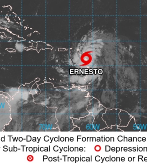 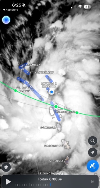 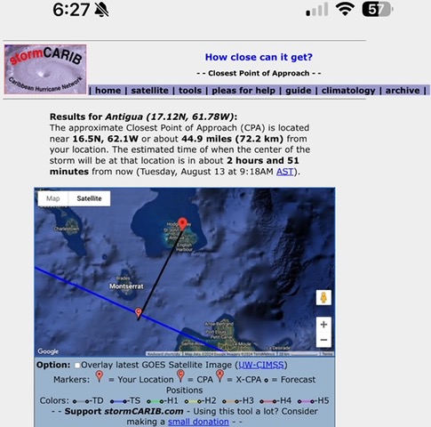 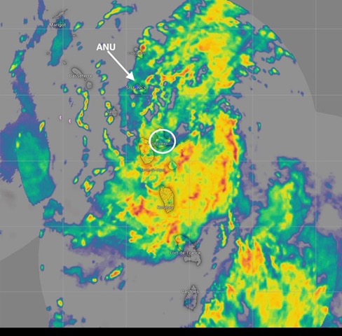 Sent from my iPhone |
|
|
- Storm Ernesto
|
- By Martha Gilkes <gilkesm at me.com>
- Date: Mon, 12 Aug 2024 20:07:06 -0400
|
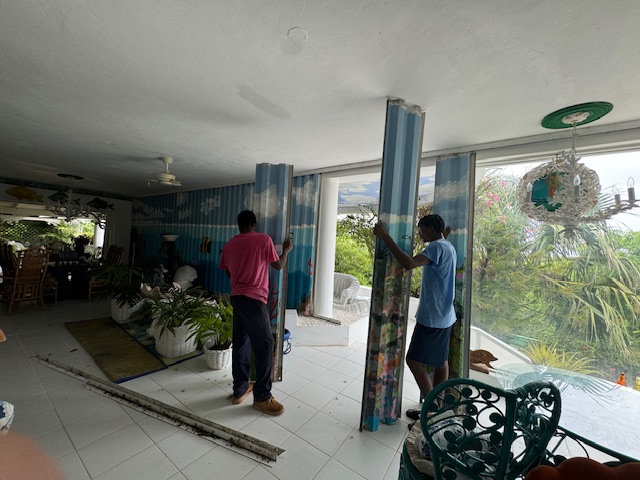
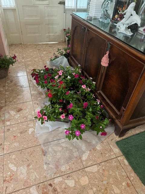
Officially storm Ernesto now and  we made the decision to put up hurricane
shutters!!  Mainly to stop rain flooding the house but also gusts as we are
perched on a 212 foot hill so wind can be heavy!    Dragged in my window
flower boxes as the predicted heavy rains would probably be the end of them !
Our airport closed for the night and  the system has moved a bit closer to
Antigua but thankfully still not a hurricane.   Meant to be lots of rain over
the next 24 hours.  Keep safe !
Sent from my iPhone
|
|
- Update From Jolly Harbour, Antigua and Barbuda 2:15 PM
|
- By Linda Toth <ltothtravels at gmail.com>
- Date: Mon, 12 Aug 2024 14:25:49 -0400
|
Good afternoon from Jolly Harbour, Antigua.
We are watching closely as Cyclone 5, soon to officially become Tropical Storm Ernesto, approaches our Leeward Islands.
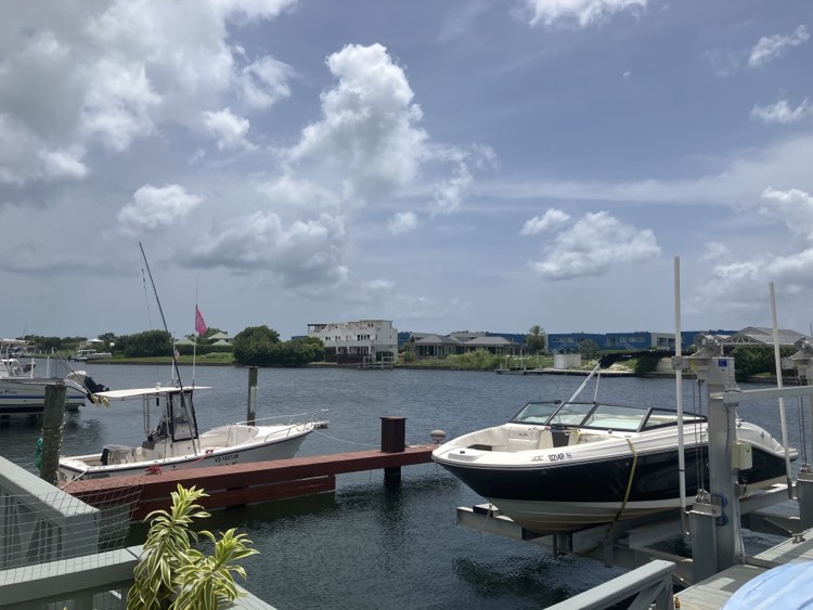
Being prepared for storms and hurricanes is vital and we are taking the time now to do so. We have all been informed to move vehicles to higher ground, put sandbags up against our doors and close the hurricane shutters tonight before sunset. We were also told that we may experience power outages, flash flooding and mudslides. Many of the boats here have been removed from the harbour and placed in the dockyard for safe keeping.
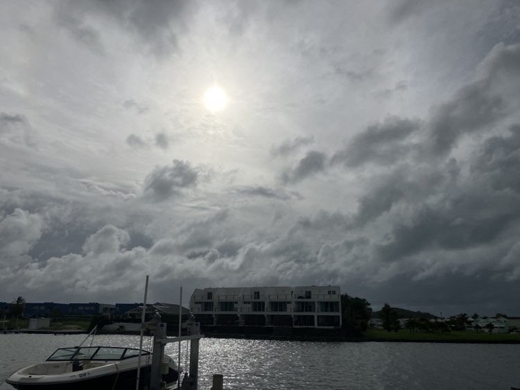
At the time I write this update, the storm is approximately 360 miles east southeast of Antigua and Barbuda. The sun is shining here in the harbour with a gentle warm breeze. This is the calm before the storm, giving us time to prepare.
Living in the Caribbean we understand that weather can change quickly and we see from the spaghetti models that we will be in Ernesto's path, however, the good news is that it will leave quickly turning north.
This afternoon Air Force Hurricane Hunters investigated and determined that tropical storm conditions and heavy rainfall in the Leeward islands are expected either late tonight or early Tuesday morning. The job of a NOAA Hurricane Hunter pilot impacts the day to day lives of people like us. The most accurate information about a storm is found within the storm itself. This information dictates how people prepare to ride out a storm or whether people evacuate and businesses close. This can ultimately save lives and millions of dollars in property.
Preparedness and staying calm is key in times like these. Stay safe everyone, Linda Toth 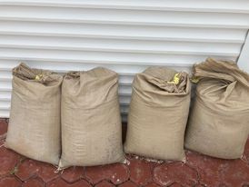
|
|
- Antigua Barbuda update
|
- By Martha Gilkes <gilkesm at me.com>
- Date: Sun, 11 Aug 2024 18:39:31 -0400
|
Sent from my iPhone
|
|
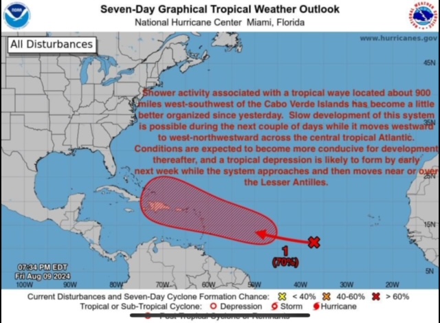
- AL 98. Weather !!
|
- By Martha Gilkes <gilkesm at me.com>
- Date: Sun, 11 Aug 2024 14:02:57 -0400
|
Download Attachment Available until Sep 10, 2024 WE in the leeward islands are closely watching this and the HURRICANE HUNTERS. WILL FLY THE SYSTEM SOON WHICH GIVES US MUCH BETTER INFORMATION. We just pulled our boat 🛶 out. In case !!!
000
NOUS42 KNHC 111736
REPRPD
WEATHER RECONNAISSANCE FLIGHTS
CARCAH, NATIONAL HURRICANE CENTER, MIAMI, FL.
0135 PM EDT SUN 11 AUGUST 2024
SUBJECT: TROPICAL CYCLONE PLAN OF THE DAY (TCPOD)
         VALID 12/1100Z TO 13/1100Z AUGUST 2024
         TCPOD NUMBER.....24-072 CORRECTION

I.  ATLANTIC REQUIREMENTS
    1. SUSPECT AREA (EAST OF THE LESSER ANTILLES - AL98)
       FLIGHT ONE - TEAL 74          FLIGHT TWO - NOAA 42
       A. 12/1730Z                   A. 13/0000Z
       B. AFXXX 0205A CYCLONE        B. NOAA2 0305A CYCLONE
       C. 12/1430Z                   C. 12/2045Z
       D. 15.0N 55.0W                D. 15.4N 57.1W
       E. 12/1700Z TO 12/2030Z       E. 12/2100Z TO 13/0245Z
       F. SFC TO 10,000 FT           F. SFC TO 15,000 FT
       G. FIX                        G. TAIL DOPPLER RADAR
       H. WRA ACTIVATION             H. WRA ACTIVATION

       FLIGHT THREE - TEAL 75        FLIGHT FOUR - NOAA 43
       A. 12/2330Z,13/0530Z          A. 13/1200Z
       B. AFXXX 0405A CYCLONE        B. NOAA3 0505A CYCLONE  (CORR)
       C. 12/2045Z                   C. 13/0830Z
       D. 15.4N 57.0W                D. 16.3N 60.8W
       E. 12/2300Z TO 13/0530Z       E. 13/0900Z TO 13/1300Z
       F. SFC TO 15,000 FT           F. SFC TO 15,000 FT
       G. FIX                        G. TAIL DOPPLER RADAR
       H. WRA ACTIVATION             H. WRA ACTIVATION

       FLIGHT FIVE - TEAL 76
       A. 13/1130Z,1730Z
       B. AFXXX 0605A CYCLONE
       C. 13/0930Z
       D. 16.3N 60.7W
       E. 13/1100Z TO 13/1730Z
       F. SFC TO 15,000 FT
       G. FIX
       H. WRA ACTIVATION

    2. OUTLOOK FOR SUCCEEDING DAY:
       A. CONTINUE 6-HRLY FIXES IF SYSTEM DEVELOPS.
       B. TWO ADDITIONAL NOAA P-3 TAIL DOPPLER RADAR MISSIONS INTO
          AL98 FOR 14/0000Z AND 14/1200Z, DEPARTING TBPB AT 13/2015Z
AND 14/0730Z, RESPECTIVELY. |
|
|
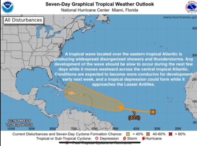
- Continued Storm watching.
|
- By Martha Gilkes <gilkesm at me.com>
- Date: Sat, 10 Aug 2024 08:07:28 -0400
|
We in Antigua & Barbuda 🇦🇬 are watching this carefully.   Already doing so prep
in case this develops quickly !
|
|
- STORM WATCHING
|
- By Martha Watkins Gilkes <marthawatkinsgilkes at gmail.com>
- Date: Thu, 8 Aug 2024 17:54:30 -0400
|
WE  IN  ANTIGUA  ARE  ON  ALERT  AGAIN.    This  system  will probably be
developing in the next  week and possibly  coming our way …. hopefully  not as
a  HURRICANE.

EYES  TO THE EAST !!!

>
>
>

>
> Sent from my iPhone
|
|
- STORM WATCHING
|
- By Martha Watkins Gilkes <marthawatkinsgilkes at gmail.com>
- Date: Thu, 8 Aug 2024 17:54:30 -0400
|
WE  IN  ANTIGUA  ARE  ON  ALERT  AGAIN.    This  system  will probably be
developing in the next  week and possibly  coming our way …. hopefully  not as
a  HURRICANE.

EYES  TO THE EAST !!!

>
>
>
>
> Sent from my iPhone
|
|
- Thoughts after Beryl
|
- By Ann P <annlouisephelan at gmail.com>
- Date: Wed, 10 Jul 2024 08:52:02 -0400
|
Like most of you, I have been glued to social media to follow what has transpired in the Caribbean post Beryl. It is staggering to see 5 islands so devastated. With the amazing relief efforts underway, there is still so much to consider; PTSD due to trauma, animal welfare, healthcare and long term considerations. I came across this article on the Facebook Page WIld Caribbean. Barbuda was left so vulnerable after Irma. I hope the people in Union, Mayreau, Canouan, Carriacou, Petite Martinque and others are able to retain their land and get back to living. The carbon footprint for these islands is small but the environmental disasters will impact these fragile places year after year.
Ann Phelan
|
|
- Antigua weather!
|
- By Martha Gilkes <gilkesm at me.com>
- Date: Tue, 9 Jul 2024 04:35:01 -0400
|
Sharing Steve Coghlans post (thanks Steve) and nice to have some quiet time
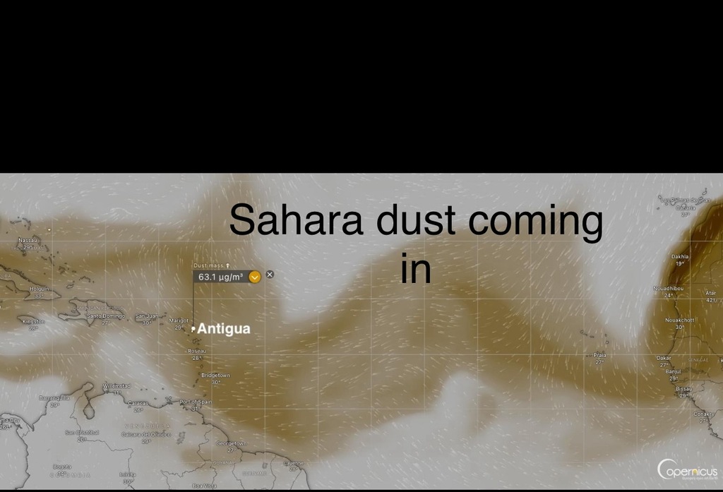
after the nightmare of hurricane Beryl. Many don’t know about our “dust”.
Goggle it for more ! We continue to have eyes 👀 to the east as we “weather
the hurricane season “.
The SAL (Sahara Air Layer) is quite active at the moment, and as a result there
are high dust levels over much of the Atlantic and even the Caribbean
Basin........Persons whose health is adversely affected by this dust should
take note and precautions as necessary!
Sahara dust over the Atlantic is not a completely negative issue for us
however, as it causes very dry and sinking air which provides a hostile
environment for tropical cyclone formation and development.
Additionally, the dust helps to keep the Sea Surface Temperatures (SSTs) cool
by shading some of the sun's rays from the ocean surface....It might not make
much of a difference this year, as these waters are already much warmer than
usual, but every little bit helps I reckon!
The Atlantic to the East of the Eastern Caribbean is quiet at this time!
|
|
- Palm Island
|
- By Ann P <annlouisephelan at gmail.com>
- Date: Thu, 4 Jul 2024 06:16:14 -0400
|
I am sorry to share more news, Palm Island is gone
|
|
- Gratitude
|
- By Ann P <annlouisephelan at gmail.com>
- Date: Thu, 4 Jul 2024 06:12:34 -0400
|
I have been glued to my many internet weather sources for days. Anyone connected to the Caribbean feels darkness that has settled amongst the community, post Beryl.
I started tracking storms in the late 80's when I lived in Antigua. A few times when off island during hurricanes, I used ham radio operators to relay information to my husband. Times have changed. Gert, how long have we had this amazing community? How grateful I am to have this connection to stay close to the islands whether I am in the Caribbean or on Cape Cod.
I am gutted about the tragedy that is unfolding in Carriacou and Petite Martinique. I was in Carriacou in 1990 and was planning a trip back in March. 30 minutes of weather created hell for the people. There is some astounding footage of Beryl during and after.
Union was one of the 11 islands I visited in 7 days (work trip) in 1990. WC Kitchen has been reporting from there. They are incredible, really. Their reports are staggering. I heard Mayreau was hit too. There used to be a hotel there, Salt Whistle Bay. I had lunch there and later swam in the Tobago Cays. How will they bounce back? How is Palm? I met the owner Coconut Johnny once and was a rep for the property. I hope to hear all is well.
Thanks for keeping this community alive, Gert and Dave and all the weather spotters. Gert needs some change to pay the fees to keep this site running. If you can add a little to the fund, it will be wonderful.
I am a Mindfulness Based Stress Reduction Teacher (MBSR) and one word that has created calm in my own crazy life is "impermanence.".
PM Mitchell of Grenada made a comment in his address. The summary was his country had little contribution to the fossil fuel mess yet his islands are going to face devastation as seen already.
Be well
Ann Phelan
|
|
- Antigua this afternoon
|
- By Martha Watkins Gilkes <marthawatkinsgilkes at gmail.com>
- Date: Mon, 1 Jul 2024 16:34:27 -0400
|
>

4 pm  MONDAY  and Antigua  is  covered in the outer bands and clouds from
Hurricane Beryl.   Quite gusty  winds  here on the  East  Coast  and rough seas
 at HALF MOON BAY.     I  am  with out  power   with APUA coming  to  try to
restore  to  some of the homes in the area.    Not sure  WHY as  we have NOT
HAD SUCH STRONG  WINDS.   Sadly  very little rain also.  Seeing tragic reports
from  Grenada  with   an address by the Prime  Minister on what they fear is
terrible damage on  Carricou and the smaller islands as we wait more  details.
  Hopefully no loss of life.       Antigua was spared  this time  but  we know
we have  a long  hot summer ahead  and have to be  prepared for the worst.
Tragic times   with  global  warming  and the  effects.

>
> Thankful to GERT AND  DAVE FOR  STORM CARIB and the service this provides in
> getting  info out there.
>
>
>
>
>
|
|
- 4 am Monday Storm Carib Report
|
- By Martha Gilkes <gilkesm at me.com>
- Date: Mon, 1 Jul 2024 04:02:08 -0400
|
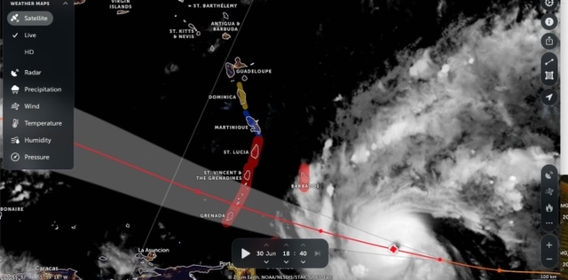
| All quiet here. 4 am. Even tree frogs singing. But this sat shows outer bands in upper area to pass. Devastated to see the monster approaching Grenada st Vincent & Grenadines. Hopefully Barbados spared the worst 🙏. https://www.myfoxhurricane.com/storm2_satellite.html
|
|
|
- Antigua Met office warning
|
- By Martha Gilkes <gilkesm at me.com>
- Date: Sun, 30 Jun 2024 19:11:53 -0400
|
Just out. We may get some gusty winds from outer band and high seas
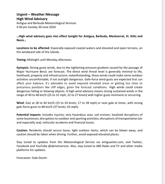
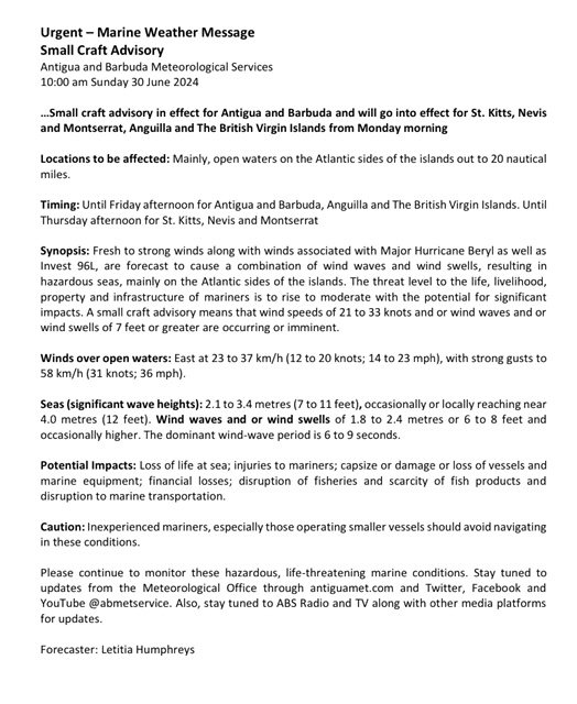
Sent from my iPhone
|
|
- Hurricane Beryl
|
- By Martha Gilkes <gilkesm at me.com>
- Date: Sun, 30 Jun 2024 09:32:39 -0400
|
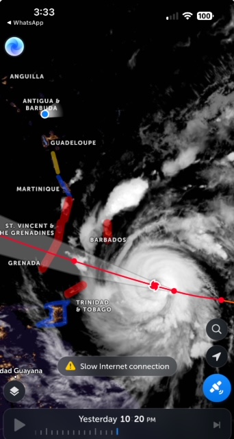
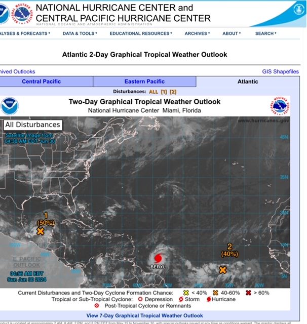
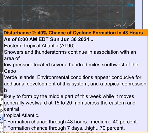
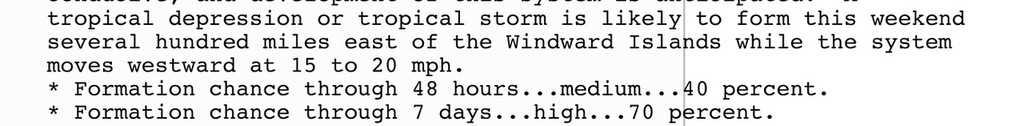
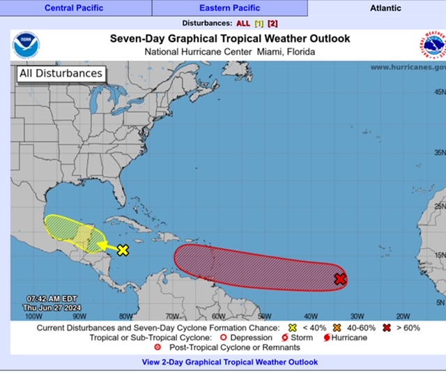
On this Sunday morning, the last day of June, it feels surreal this early in the hurricane season to be tracking what is becoming a monster hurricane - NHC says it will be a CAT 4 (winds 130 -156 mph) which is what HURRICANE LUIS was in 1995 when it tore up Antigua and my home ! My heart goes out to those in the path (Barbados is home to my husbands family ) and Grenada was my home as a Peace corps volunteer in 1974 with many friends there…..and a long time friend in St Lucia — so while I am thankful Antigua is not getting hit it is heartbreaking to see these islands affected— and others in the path beyond - ALSO watching DISTRUBANCE 2 just behind the hurricane with concerns on this and the path it will take. As of now it is moving ‘“GENERALLY WESTWARD” - the same path as Hurricane Beryl but these systems often make a north turn so those of us in the Leeward islands need to pay close attention. It is going to be a trying summer “weather watching”. 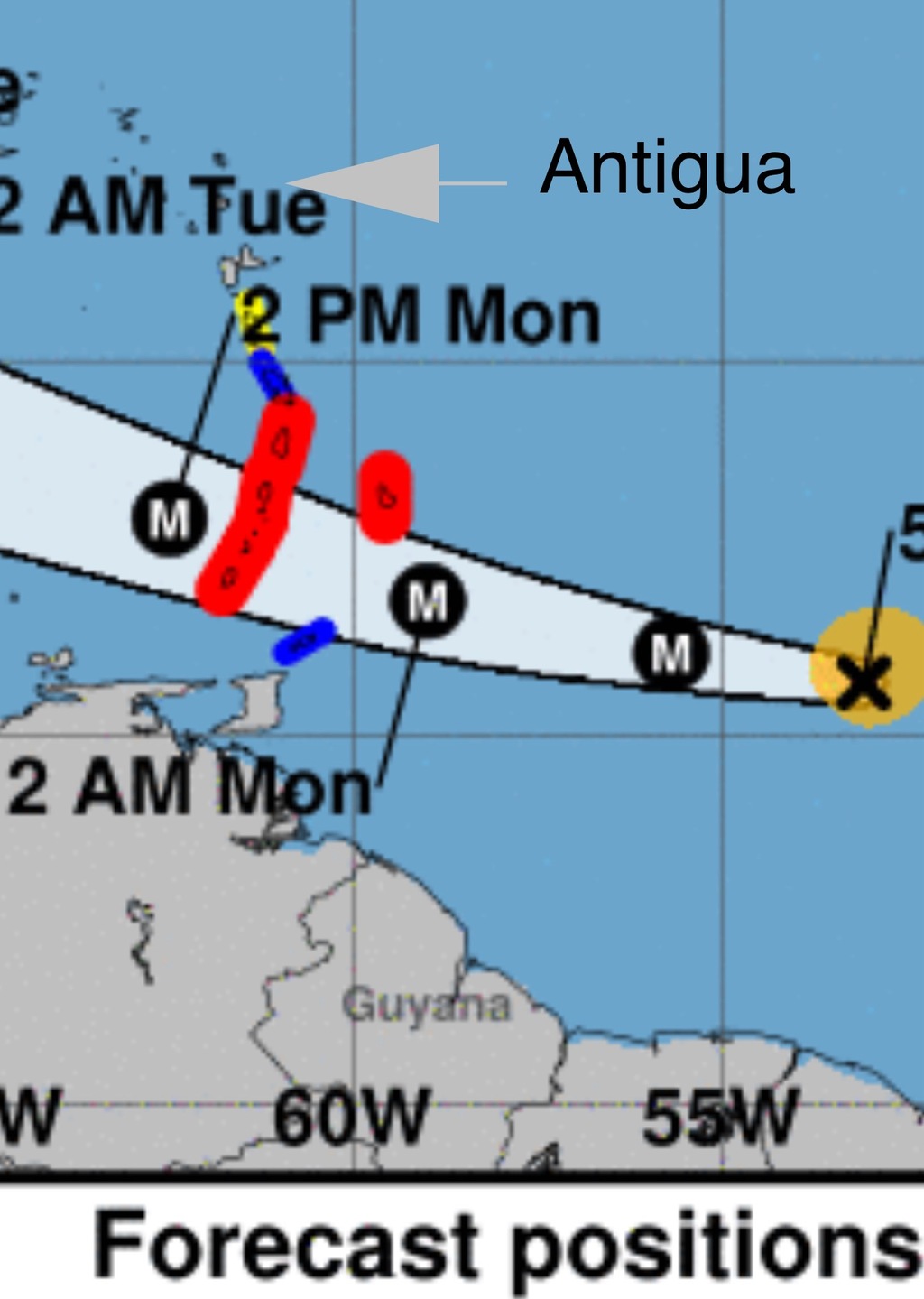
Sent from my iPhone |
|
|
- WEATHER WATCHING FROM ANTIGUA
|
- By Martha Watkins Gilkes <marthawatkinsgilkes at gmail.com>
- Date: Fri, 28 Jun 2024 16:12:04 -0400
|
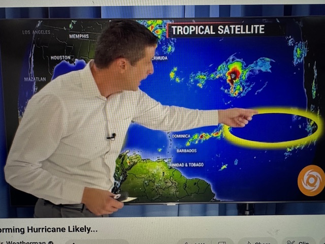
IT SEEMS looking at the models, 95 L WILL STAY SOUTH OF the LEEWARDS and track thru the WINDWARDS hopefully AS A STORM AND NOT A HURRICANE. There is a DISTRUBANCE JUST BEHIND 95 L that may do a more NORTH TURN so we are all watching . 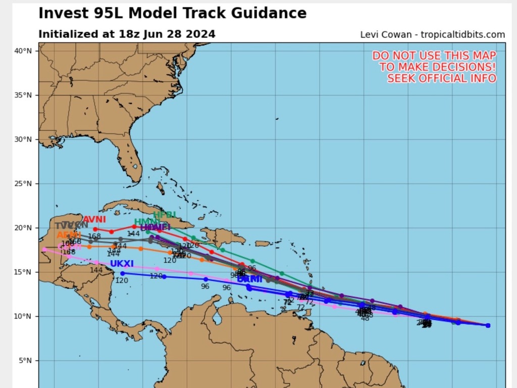 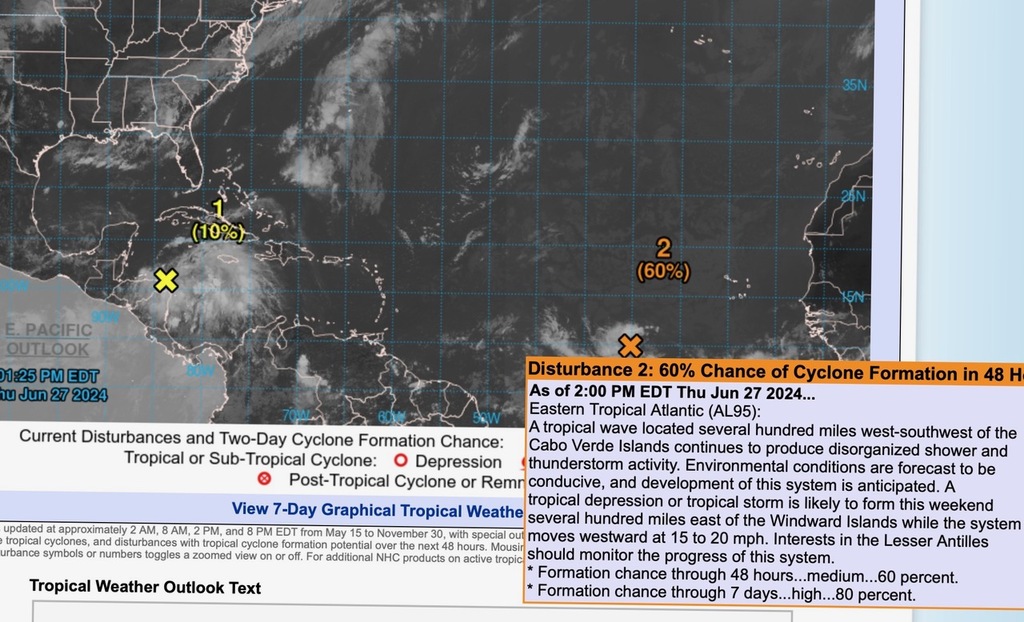 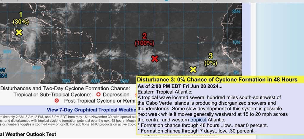
|
|
|
- Possible weather
|
- By Martha Watkins Gilkes <marthawatkinsgilkes at gmail.com>
- Date: Thu, 27 Jun 2024 08:28:38 -0400
|
Early days to be seeing this !!!

> This  system  seems to be  staying  SOUTH    but could do a north turn as
> they often do… It  is moving around   20  mph  ( 300 miles to the  east )
> so  SHOULD  be  thru  the islands  in     24 hours      (FRIDAY)… or  i would
>  think  by    SAT … they do slow down tooo!!     SO I WOULD  THINK  BY SUNDAY
>   WE WOULD  SEE IT  GONE.  ( but  always something else  behind   !!!    We
> never know  with  weather…
>
>
>
>
>
> Sent from my iPhone
|
|
- Tropical wave
|
- By Ann P <annlouisephelan at gmail.com>
- Date: Wed, 26 Jun 2024 14:44:08 -0400
|
I was reading Crown Weather's daily tropical report that suggested some weather possible for T&T and Barbados. It will be interesting to see how and if this develops. I am always concerned about flash floods and poor infrastructure. In the US, climate change is already wreaking havoc on towns and cities; fire, floods, heat. Be safe all.
Ann Phelan
|
|
- Hurricane season is here again
|
- By Martha Gilkes <gilkesm at me.com>
- Date: Tue, 4 Jun 2024 11:49:46 -0400
|
JUNE 1st - THIS DATE HAS MIXED FEELING IN MY LIFE………. THE START OF THE HURRICANE SEASON which for those of us ISLAND BASED is becoming more and more of a “worrying time” as climate change is causing more severe hurricanes. It is the “small island states” paying the highest price for what the “BIG WORLD COUNTIRES” have caused with the damage to the ozone layer and atmosphere. June 1st is ALSO my ANNIVERSARY ( this year of 43 years ) so it is also a “celebration day”!
AND NOW THE OFFICIAL HURRICANE SEASON HAS STARTED. I consider myself somewhat of a seasoned hurricane “amateur expert” having gone thru the eye of 5 HURRICANES - One IN THE AIR FLYING WITH THE elite US HURRIANE HUNTERS into HURRICANE FABIAN ( Category 4 ) - but that is another story !!!
All forecasts are SERIOUS ones… and we expect severe heat during the summer months…….NOAA is saying 17 to 25 named storms and 4 -7 major hurricanes ! There is only SO MUCH homeowners can do to be prepared but I for one WILL BE GETTING PREPARED well ahead ( generator serviced with fuel on hand , gutters cleaned, checking all hurricane shutters food supply on hand, first aid supplies on and on - we all should know and have the “check list” SO “people get ready” as that song says. A few years back we added rafter supports in all of our roofs across the normal rafters which we were advised gives a lot of strength to the roof not ripping off in a hurricane. So hope that extra step helps !
IT IS IMPOSSIBLE to know which islands will fall victim to a hurricane and even when one is barreling down on an island there can be a last minute turn ( as happened to Antigua with HURRICANE IRMA in September 2017 as she approached us in what forecasters said was a Category 5 PLUS PLUS PLUS causing the HAIR TO STAND UP on our heads…. and during the night she took a NORTH TURN and DESTROYED our sister island of Barbuda, sparing Antigua.
THE OLD TIME SAYING for hurricanes
JUNE TOO SOON JULY GET READY SEPTEMBER REMEMBER OCTOBER ALL OVER
But this is no longer the norm as THERE IS NO NORM! EYES TO THE EAST as we begin the “long hot summer” !!! 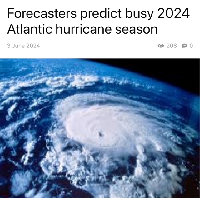  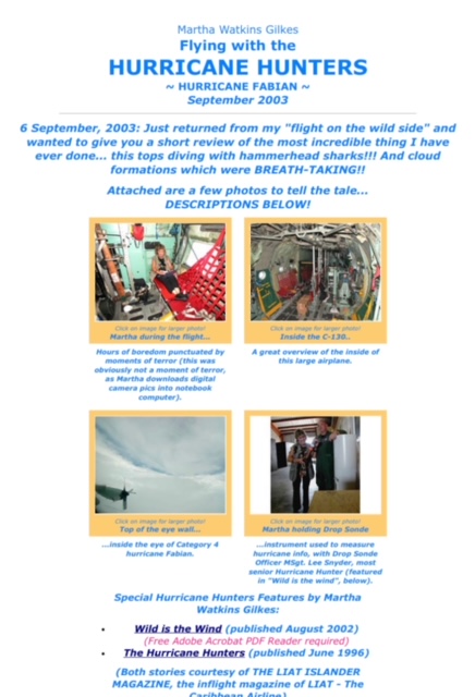  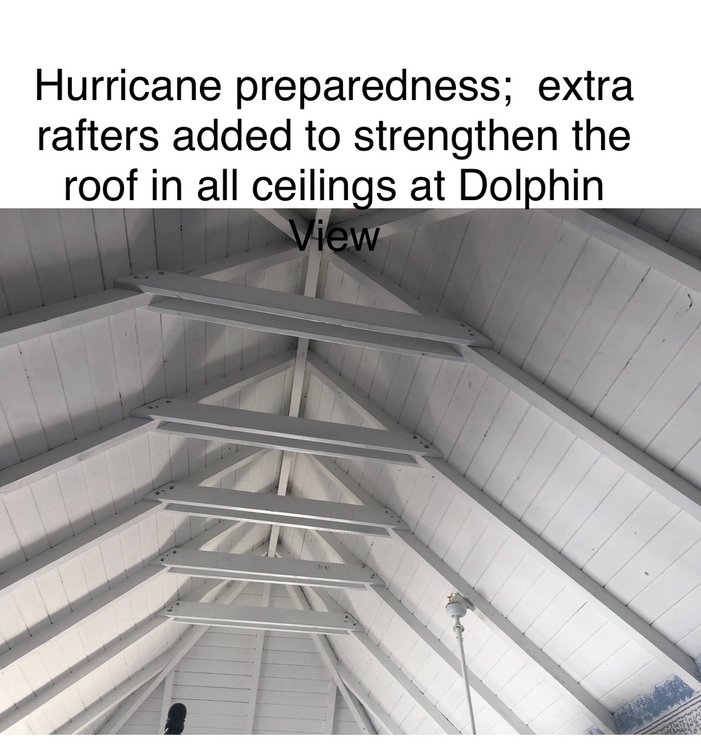
Sent from my iPhone |
|
|