|
|
- - - 2025 Hurricane Season - - -
|
- Highly Catastrophic and Dangerously Menacing Category Five Melissa...
|
- By Fedaw Shercloh <fedawshercloh at gmail.com>
- Date: Tue, 28 Oct 2025 01:00:18 -0500
|
Our Hearts truly ache as we watch Super Powerful Category 5 Hurricane Melissa inch closer towards Jamaica. Of course, so many of our people here in Dominica, the Nature Isle of the Caribbean, vividly remember another super catastrophic & traumatic M- named storm called Maria which decimated our island just 8 years ago in September 18-19, 2017.
Our thoughts and prayers are with the People of Jamaica as Landfall is expected by later Tuesday morning. We All Hope and pray that persons moved to shelters and prepared as best as they could for this multi- day Hurricane onslaught, which appears bent on being an absolute nightmarish and apocalypticly life threatening situation for Jamaica. Also, Let's Hope and pray that Melissa does not continue to intensify any further.
On the local front we had a series of Earthquakes yesterday, Monday, 27th October;- a Major foreshock of 6.5 in the early morning, was followed by a 6 Magnitude (quake) or aftershock, and then a lesser Aftershock of 5.4 Magnitude and then a 4.9 magnitude tremor in the evening. All were centered nearer our northern French neighboring Island of Guadeloupe. Thankfully & miraculously the impacts were negligible to unnoticeable here across the Nature Isle. Some residents did feel some shaking, but a lot of persons never felt any of the quakes. My area experienced some mild or light to moderate shaking from the first two tremors, however the subsequent aftershocks were not felt.
Well, these Natural phenomena are certainly inviting us All to remain on our knees, and be ever aware that indeed we are merely a breath. Let us strive to Live in the best way possible in Keeping with God's Will, & let's leave this planet a little better than we first met it!
Blessings & Stay safe this season folks. Special Thoughts and prayers are with Jamaica. Jesus Christ is Lord! #We Are Caribbean Strong! |
|
- 98L swiftly heading west
|
- By Fedaw Shercloh <fedawshercloh at gmail.com>
- Date: Sun, 19 Oct 2025 13:20:31 -0500
|
The radar images out of Barbados clearly shows the center of 98L approaching SVG- the mainland area of St. Vincent at this time. Hopefully impacts will not be too bad overall as it moves directly over that area, and as it's peripheral effects bring impacts over the remainder of the Windward islands.
Here in the Nature Island of the Caribbean, Dominica we have been having occasional showers from morning time - some of which have been mostly moderate with a few heavy showers interspersed. One particularly heavy thunderstorm squall knocked out power for a while on the West Coast, but as of typing all utilities have been fully restored thank God.
Stay safe folks. God Bless! |
|
- 98L Consolidation...
|
- By Fedaw Shercloh <fedawshercloh at gmail.com>
- Date: Sat, 18 Oct 2025 23:53:52 -0500
|
It looks like 98L is consolidating quite nicely as it approaches the Lesser Antilles. Sites such as Windy.com etc. show that it's center of circulation is wrapping up nicely. In fact, Perhaps it may make it to Tropical depression status while coming through the Windward Islands.
Nonetheless, tropical storm conditions are likely from this Sunday into Monday. 98L is yet Another system which is seemingly exhibiting the "Lesser Antilles rule" often referred to by fellow blogger Conan Shillingford (Fr.) as systems tend to close off their center of circulation; consolidate and intensify their convection while nearing the Lesser Antilles Islands. It's a wait and see at this point... |
|
- 98L Bears watching... Cyclogenesis is likely
|
- By Fedaw Shercloh <fedawshercloh at gmail.com>
- Date: Sat, 18 Oct 2025 14:51:44 -0500
|
We need to keep an eye on what is now an area of tropical weather investigation just to the East of the Lesser Antilles labelled as 98L.. It seems like the wave preceding it may also act as a sort of precursor event with the more serious tropical storm conditions likely by Sunday afternoon or evening in the windward islands as the vigorous tropical wave labelled as 98L approaches.
Stay safe everyone. Blessings! |
|
- Jerry's loitering...
|
- By Fedaw Shercloh <fedawshercloh at gmail.com>
- Date: Fri, 10 Oct 2025 08:51:43 -0500
|
Thankfully the weather conditions have generally improved quite a bit this morning compared to what obtained late last night and into the wee hours of the morning. We are still expecting more Inclement weather though, and although the wind direction has now changed to coming predominantly from the South East we are in many respects receiving higher wind gusts now compared to last night.
Of course, we are not yet 'fully out of the woods' so additional vigilance should be maintained. Hopefully, the additional expected rainfall will not be too heavy. So far there are no no significant reports of flash flooding etc. across the Nature Island which is good news. Also, All utilities have held up soundly in my area after a bit of a beating from last night so kudos to our utility companies & networks -post Erika/ Maria.
Incidentally I haven't heard anything Official Re: schools which is unfortunate given the prevailing conditions. I think a lot of parents may assume that there might not have been given the continued Inclement conditions island-wide.
However, this should really have been a no-brainer for the officials in light of the safety of our kids etc. St. Lucia and Martinique including Guadeloupe have All cancelled schools as a precaution. SMH....
I suppose with the recent cancellation when the last system affected us (94L in September) the Ministry of Education may have been hesitant in that regard... Trusting that everyone will Keep safe as Jerry continues to move away from our area.
Blessings
|
|
- Non-Jester Jerry...
|
- By Fedaw Shercloh <fedawshercloh at gmail.com>
- Date: Fri, 10 Oct 2025 00:56:10 -0500
|
Well Jerry is certainly not joking... Initially We had been having the occasional feeder band activity from about 10p.m., which were really on the mild side on the West Coast. However, things picked up by about 11:30p.m. with more intense convergence and feeder band activity island-wide. At that point the East and south of the island had been having the Worst of conditions being reported up until about midnight (12a.m.)
Currently, However this more extreme rainfall incidence and associated adverse conditions have now spread to the West Coast where gusts have also recently picked up -in the range of probably 25mph tops. Winds continue to be mainly out of the South West and West for now with some variable gusts as well.
Whereas just about an hour ago there was mainly only light to moderate showers with occasional lightning flashes- right now ongoing thunder showers and thunderbolts have made there presence felt during the last 45 minutes or so. At the moment the heavy rains are abaiting as the thunder rumbles continue -Until the next convective band comes around.
I really hope that persons living in the more vulnerable parts of the island took this tropical system seriously enough. Storms at night are always more unnerving and of course PTSD filled. On a positive note though -from my commute back from town today -it seemed like most of the fisher folk heeded the high seas warning and had their boats hauled ashore, or placed in safe harbour as may be available.
Hopefully, daylight will not reveal too many impacts from Jerry's feeder band activity over the Nature Isle. We continue to be under the effect of a competing low level center of circulation within Tropical storm Jerry, or a secondary convective blob/ blowup. Need I say- we are all thankful that Jerry was not any stronger having come so near- to over- the Lesser Antilles Chain of islands. Will update as may be necessary...
God Bless! |
|
- First round...
|
- By Fedaw Shercloh <fedawshercloh at gmail.com>
- Date: Thu, 9 Oct 2025 14:55:34 -0500
|
The winds coming out of the West have been steadily building and peaked a while ago with the first substantial Western peripheral band, which thankfully was weak, & brought mostly light rainfall. We do expect further squalls and bands into tonight as per the forecast. As Always time will tell -regarding the impacts which Jerry may bring to our area.
Blessings! |
|
- The calm before the storm (proverbial)...
|
- By Fedaw Shercloh <fedawshercloh at gmail.com>
- Date: Thu, 9 Oct 2025 10:44:38 -0500
|
Well Jerry is definitely nigh as it swoops ever closer to the island chain... Here in the Nature Island of the Caribbean, Dominica, it's getting increasingly Overcast as one of the peripheral bands of Jerry gradually closes in. It's sort of the proverbial calm before the storm at this point. Seas on the Western coastline are expected to build by this evening, however, the Atlantic is already starting to produce some swells and will grow more rough as the day progresses.
Will report further as conditions warrant...
As Always stay safe and prepared. God Bless! |
|
- Jerry's Peripheral bands on the way...
|
- By Fedaw Shercloh <fedawshercloh at gmail.com>
- Date: Thu, 9 Oct 2025 03:21:10 -0500
|
Well, as Jerry daws nearer it's a wait and see at this point. Yet, as always- Better safe than sorry with regards to Tropical Systems and their associated storm impacts. Indeed, Precaution is always better than cure...
Hopefully, Most persons did some amount of preparation for the storm even though a storm watch or alerts for Flash flooding etc. have not Yet been issued. I was pleased to see our National water company (Dowasco) -advising persons to stock up early on at least three days supply for their households -given the expected water turbidity etc. & possible interruptions to the supply.
This good advice serves both as a safe measure and precaution for families in particular. In this era of Climate change and accelerated Human caused Global warming it's imperative that consistent mitigatory steps are adopted by everyone as much as possible.
-Likely island impacts from T.S. Jerry as per our Met Service: (8/10/2025)
⚠️🌪️ TROPICAL STORM JERRY UPDATE – (5:00 PM AST) 🌪️⚠️
Unstable conditions will continue to affect the area tonight. Expect mostly cloudy skies with scattered showers and possible isolated thunderstorms. An increase in showers can be expected from Thursday as Tropical Storm Jerry nears the area.
🚨 People in areas prone to flooding, landslides, and falling rocks are advised to remain on alert and exercise extreme caution.
🌊 SEAS: 🌤️ Tonight – Slight to moderate, with waves up to 8 ft (east coast) and 5 ft (west coast). 🌊 From Thursday – As Tropical Storm Jerry approaches, expect deteriorating sea conditions, with swells of 10–12 ft in open water on the east coast and 7–8 ft on the west. ⚠️ All sea users should monitor conditions closely and remain prepared.
📍 STORM DETAILS (5:00 PM) 🌀 Location: 14.8°N, 54.7°W 📏 Approx. Distance: 460 miles east-southeast to east of Dominica ➡️ Movement: West-northwest at 23 mph (37 km/h) 💨 Winds: 65 mph (95 km/h) 📉 Pressure: 1000 mb
🌀 Jerry is expected to become a hurricane by Friday. 🌧️ Rainfall: 2–4 inches with gusty winds expected across Dominica from Thursday.
Residents and interests in Dominica should continue to monitor closely the progress of Tropical Storm Jerry.
#DominicaWeather #TropicalStormJerry #StaySafeDominica #WeatherUpdate #CaribbeanWeather #HurricaneSeason
Blessings! 🙏🏿 |
|
- Tropical Storm Impacts- very Likely. For Dca....
|
- By Conan Shillingford <conanshillingford at gmail.com>
- Date: Thu, 9 Oct 2025 00:50:44 -0500
|
At this rate Jerry is Highly likely to bring Tropical storm impacts to some of the Windward islands as well as the Leeward islands- given it's sustained rapid forward motion and it's current West north Westerly direction, which it has maintained.
Perennially it's always Most baffling as to why there is such undue delay and hesitance in the issuance of the necessary & requisite watches/ alerts and advisories- in a timely fashion for the Nature Isle. Clearly this will be a last minute type of issue unfortunately Re: Thursday's eventual School and Work official statements etc.
Also, While there are similarities with the approach of Jerry to that of Erika (2015), the most likely analog of this storm May be that of a blend of Phillipe' & Tammy (both in 2023). An interesting read of Erika's tracking complications/ inaccuracies (2015) states- " Contrary to predictions of a northwesterly recurvature, the cyclone persisted on a westerly course and passed through the Leeward Islands just north of the Guadeloupe/Dominica area." Hopefully, this will not end up being a form of dejavu.
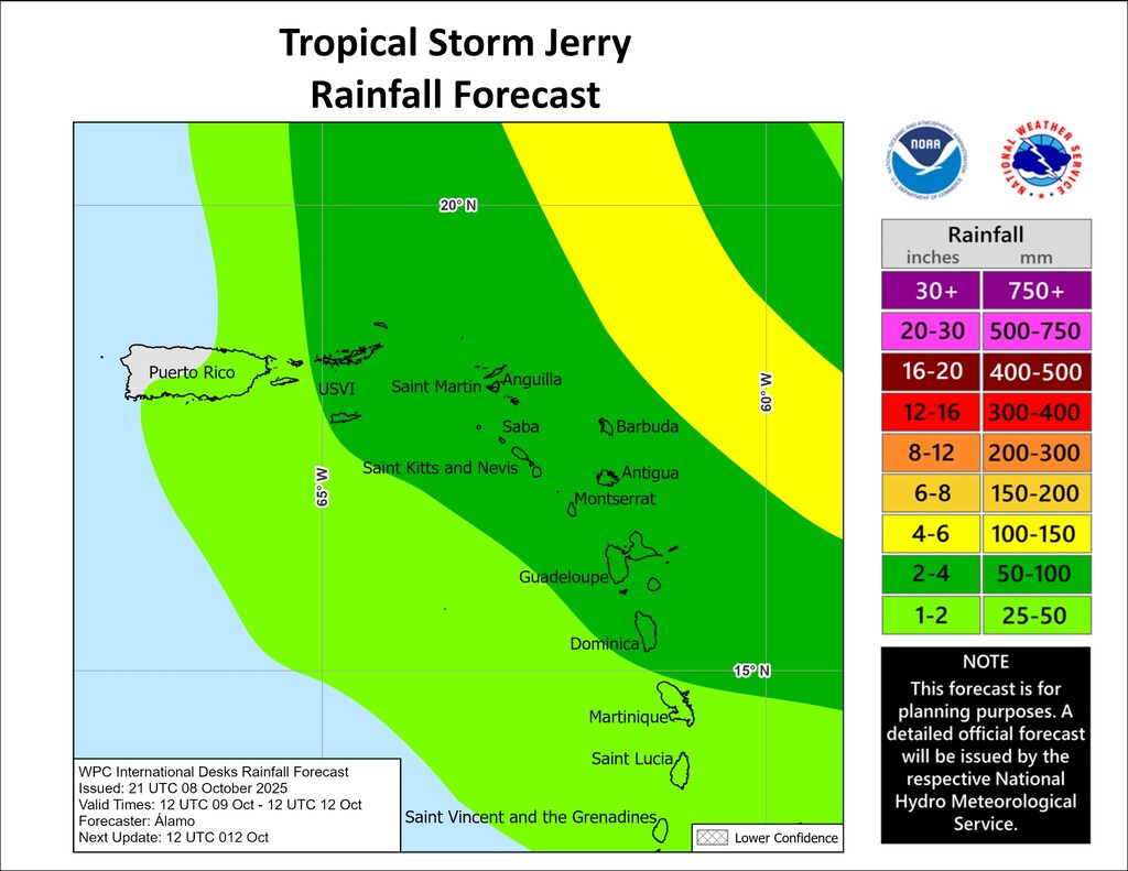
& Of course, Any potential wobble, and or rapid and explosive deepening & strengthening of Jerry could mean having an intensifying storm or hurricane very near, Or over some of the Lesser Antilles Islands. A similar scenario to that of Jose' (1999), or like that of Marilyn (1995) could also play out- God forbid. *The graphic below clearly shows the anticipated impacts Re: Extreme Rainfall and potential flash flooding accompanied by wind gusts to Tropical storm force and other hazards...
Please stay safe and prepared everyone. Blessings! |
|
- Expansion of Watches for the Lesser Antilles...
|
- By Fedaw Shercloh <fedawshercloh at gmail.com>
- Date: Wed, 8 Oct 2025 00:26:03 -0500
|
The latest Expansion of Watches Southward in the Leeward islands was really Highly prudent and rational -given Tropical Storm Jerry's forward speed and current Latitude at this time. & Likewise it would certainly be very sensible and Prudent to extend a watch for the Nature Island, Dominica. I'll be watching closely this time around yet again to see what obtains in this regard, & whether the 'matter of course' decision may be left for 'last minute'.
Afterall we are just South of Guadeloupe and it's dependencies... For all intents and purposes- *"Guadeloupe and the adjacent islands" -might as well include Dominica. As a matter of fact, It would not be surprising to see the French Government eventually include even Martinique in some sort of Cyclonic advisory and Watch.
As per the latest NHC Advisory (7th, Oct) at 11P.M. -the following new watches were added and the updated list is stated Below: 'The Meteorological Service of France has issued a Tropical Storm Watch for Guadeloupe and the adjacent islands. SUMMARY OF WATCHES AND WARNINGS IN EFFECT: A Tropical Storm Watch is in effect for... * Antigua, Barbuda, and Anguilla * St. Kitts, Nevis, and Montserrat * St. Barthelemy and St. Martin * Sint Maarten * Saba and St. Eustatius * Guadeloupe and the adjacent islands.
N.B. at the 5P.M. Advisory -only Barbuda was under a watch, which should have obviously included Antigua as a basic issue of Prudence/ rationale- Re: Preparation, Mitigation and preservation of Life.
Typically Watches only signify the possibility of certain Storm conditions, and their issuance are always a greater measure of an assurance of public awareness, preparation and sustained Cyclonic vigilance & readiness. Let's Hope & Pray for the best with Jerry for All of our Isles.
Stay safe and prepared folks. Bless up! |
|
- Tropical Storm Jerry forms...
|
- By Fedaw Shercloh <fedawshercloh at gmail.com>
- Date: Tue, 7 Oct 2025 12:34:21 -0500
|
Well here comes Jerry... A bit of uncertainty surrounds this storm as to its eventual track, which may bring it over or near the Leeward islands. At this point it's still speeding Westward at about 24mph as per the latest NHC advisory, and is at a latitude of 11.5 North. At this rate Climatology, and multiple post cyclonic cumulative experience tells me that we in the Nature Isle need to also be on the lookout as we are considered to be ('straddling') at the mid point of the Leeward island chain, & the Windward Isle grouping to which we officially belong.
The last thing any of us want in the islands is an unexpected landfall occuring within a fairly short space of time (a possibility -if Jerry's track remains more Westerly than north Westerly) with a frightful possibility of Rapid intensification on top of all of that.
Vigilance is certainly needed over the next 48hrs as Jerry will make it closest approach by late Thursday into Friday. The official forecast also calls for intensification and Jerry is expected to be a Hurricane then... Time will tell.
Stay safe and prepared as Always everyone, and let's beef up the Prayers in Jesus' Precious Name! Blessings! |
|
- Cyclogenesis...
|
- By Fedaw Shercloh <fedawshercloh at gmail.com>
- Date: Mon, 6 Oct 2025 20:57:31 -0500
|
95L seems to be well on the way to becoming Tropical storm Jerry with ongoing increased organization. As the system continues to consolidate and establish a closed low level center of circulation over the Central Atlantic it should not be long before it's formally designated. It will be interesting to see which way Jerry eventually goes as per the track models & their early predictions.
Here in the Nature Isle of the Caribbean we have been Blessed to have the occasional shower activity; especially along the beautiful western and Northern parts of the island. This relief rainfall along with a fantastic sea breeze has kept things relatively cool making it a bit easier to beat the persistent humidity and heat index characteristic of the Tropics at this time of year.
Well as Always it's a wait and see with Pre- Jerry.
Stay safe and well prepared everybody. God Bless! |
|
- The dreaded H & I Storms...
|
- By Fedaw Shercloh <fedawshercloh at gmail.com>
- Date: Mon, 29 Sep 2025 02:33:22 -0500
|
Well, the dreaded H & I storms are here with the likes of former Category 5 Hurricane Humberto, and tropical storm Imedla. Also, Imedla has taken on the classic 'comma' appearance on satellite imagery,, which typically indicates imminent strengthening and possibly deep intensification. Hopefully it's impacts will not be too noticeable in the Bahamas.
However, with its current track and intensity projection Bermuda will likely have to look out down the road. We continue to stay vigilant here in the islands.
Stay safe & prepared everyone. Blessings! |
|
- The tail of 94L...
|
- By Fedaw Shercloh <fedawshercloh at gmail.com>
- Date: Tue, 23 Sep 2025 23:47:26 -0500
|
Sometimes there can be more sting in the end than at the beginning. Such was the case late this evening as showers and thunder showers caused more significant impacts through street and flash flooding as well as riverine flooding in the South, and parts of the South western areas of the island including in the suburbs of the city. Due to already saturated soils rainfall runoff, & excessive ponding were more problematic in the South of the island than during this morning's rains.
Here on the West Coast the rains were not nearly as heavy as in the South thankfully.
Stay safe everyone. God Bless! |
|
- 94L designation & likely development...
|
- By Fedaw Shercloh <fedawshercloh at gmail.com>
- Date: Tue, 23 Sep 2025 12:27:54 -0500
|
The NHC has finally designated the strong tropical wave just to our East as 94L -as was anticipated. 94L is currently affecting most of the windward islands at the moment. It is expected to also affect the Leeward islands as well into this evening -so vigilance needs to be maintained.
So far the effects have been varied across the Nature Island of the Caribbean, Dominica. Here along the West Coast we have had some moderate to light showers and thunder showers from last night into this morning. Thankfully most of the shower activity has not been on the heavy side so far, though the accompanying thunderstorms were relentless from last night into this morning.
However, on the East Coast of the Nature Isle and to the North some flash flooding was experienced in some of the usual areas as well as in parts of the South of the island. As a result schools across the Island are closed for the day as an added precaution.
At the Moment the winds have also died down for the most part, which were quite gusty earlier this morning. The Sun has also peeked out occasionally from under today's cloud cover. Hopefully, 94L will not be too impactful overall as we expect more adverse weather later in the day with 94L's continued passage. I will report further if warranted...
As Always stay safe this Hurricane season everybody. God Bless! |
|
- Back-loaded Season..
|
- By Fedaw Shercloh <fedawshercloh at gmail.com>
- Date: Tue, 23 Sep 2025 01:26:17 -0500
|
Well 2025 is certainly adding up to be a back- loaded hurricane season similar to 2024, but of course seemingly a bit more dramatic in fashion for our area. Thankfully major Hurricane Gabrielle is passing well to the East of Bermuda. To God be the Glory. Nonetheless, rapid intensification appears to be the 'name of the game' -So the tropical disturbance which has spun up to the East of the islands bears watching as it tracks westward.
We are actively monitoring the threatening weather system which is on our island doorsteps here in the Nature Island of the Caribbean, Dominica. Adverse weather conditions are likely over portions of the Northern Windward Islands, and the Leeward islands as this tropical disturbance (strong tropical wave) pulls through our area. Perhaps it might attain tropical depression status while it crosses the Lesser Antilles Island chain on Tuesday into Wednesday. It's a wait and see at this point.
As Always stay safe & prepared folks. God Bless! |
|
- Hurricane Maria's Anniversary in Dominica...
|
- By Fedaw Shercloh <fedawshercloh at gmail.com>
- Date: Thu, 18 Sep 2025 21:34:28 -0500
|
Today Mark's the 8th Anniversary of the Monster Category 5 Hurricane named Maria, which dealt catastrophic devastation to our Lovely Island. Thankfully, there is nothing close to the likes of the intensity of Hurricane Maria anywhere on the Horizon in the tropical Atlantic at this time.
On the anniversary of this mega destructive storm the weather gave us a mix of sunshine and Clouds along with rain showers- some of which were heavy at times.We're grateful for only having to deal with a tropical wave- a minor disturbance compared to what unfolded 8 years ago.
But with the Advent of Climate change we Must stay prepared, however, everyone in the Nature Island of the Caribbean, Dominica surely hopes and prays that we will not have anything near as strong as Catastrophic Hurricane Maria anytime soon. Of course, we're still keeping at least one eye on Gabrielle (expected to go north of us) and what may follow.
Stay safe everyone. God Bless! |
|
- Tropical Vorticity...
|
- By Fedaw Shercloh <fedawshercloh at gmail.com>
- Date: Tue, 16 Sep 2025 16:22:08 -0500
|
The Tropical wave just to our East seems to be consolidating a bit with enhanced convection and vorticity. It may also be one to watch in the coming days as it could spin up a low level circulation center and gain greater signs of organization. In the meantime as it's wave axis, or center approaches the mid- Leeward islands- it's rain bands are already generating quite overcast & rainy conditions over our Beautiful Nature Island of the Caribbean, Dominica. Of course, due to our persistent shower activity 🌧️-the rainbows 🌈 are out in full force spanning our gorgeous mountainous & lush landscape.
Also, A nearby trough system is currently enhancing our moisture levels so it will likely be a prolonged rainbow sightseeing treat perhaps into the weekend- as 92L approaches, which could be tropical storm Gabrielle by then. As Always time will tell...
Stay vigilant and prepared everyone. Blessings. |
|
- Tropical Cyclogenesis ...
|
- By Fedaw Shercloh <fedawshercloh at gmail.com>
- Date: Tue, 16 Sep 2025 08:39:02 -0500
|
92L certainly seems poised to become a named system much sooner than later with signs of Cyclogenesis underway. & It's unlikely to suffer the fate of 91L, which, thankfully did not develop as was forecasted. So it bears watching as it nears the Lesser Antilles Island chain. However, it remains to be seen what track it will eventually take as it approaches the Lesser Antilles by this weekend.
So far the Beautiful Nature Island of the Caribbean has been pretty wet & occasionally humid. The last tropical wave which had a bit of vorticity (spin) over the weekend gave us a few solid inches of precipitation across most of the island of Dominica especially on Saturday. The electrical- thunderstorm activity was quite impressive as well in some areas of the Nature Isle. Perhaps it was a sort of precursor to 92L as this 'seemingly back-loaded' season gets underway. Of course, Time will tell as to what potential impacts 92L and other systems following it may bring.
Stay prepared and Vigilant folks. God Bless! |
|
- 92L & other disturbances Are sure to Follow...
|
- By Fedaw Shercloh <fedawshercloh at gmail.com>
- Date: Tue, 9 Sep 2025 01:15:37 -0500
|
Well sustained vigilance is surely needed as the peak of the season and subsequently -a secondary peak are well on their way this September. & With the remnants of what was 91L seemingly passing through the Northern Lesser Antilles (Leeward islands)- we are grateful for its modest convection and nothing worse. Re: the Atlantic basin the 'low rider' tropical wave at 50W Longitude bears some watching. There is decent enough low level spin in the atmosphere on the satellite loops with this wave, and it's also approaching warmer surface temperatures.
With additional consolidation of its core at the mid levels etc. further Cyclogenesis is a possibility with this disturbance down the road as it draws much nearer to the islands, and to the main Lesser Antilles tropical development area from 55W longitude.
Stay safe this season everyone. Blessings! |
|
- The tail of 99L...
|
- By Fedaw Shercloh <fedawshercloh at gmail.com>
- Date: Mon, 25 Aug 2025 07:49:50 -0500
|
Thus far, 99L has been a full mix of weather impacts especially in the windward islands. Sunday's weather brought some brief squalls here in the Nature Island by the afternoon hours, and by yesterday evening the anticipated wind surge had fully arrived across most parts of the island. Blustery conditions prevailed through the night for the most part. Fortunately, gusts were not too strong along the North Western coastal area though.
Currently we do have moderate to heavy showers as the 'tail' of the system clears our area. We're thankful that the disturbance was not any stronger, which would have certainly been more impactful. So far the shower activity has not been squally in nature this morning, which is certainly a good thing.
Notably, despite not having a Closed low level center of circulation as per the NHC - the Mid -level center of circulation of 99L seemed significant enough given the hazards it produced- as forecasted in the windward island chain especially from yesterday.
Associated gusty winds and squalls from 99L resulted in power losses in parts of Martinique especially in the south. & Similar gusts to Tropical storm force were reported in Barbados and more so at Hewanorra airport in St. Lucia (*airport data via weathercarib), which could have had similar impacts like in Martinique. See the respective links below. Wind reports from Barbados/ St. Lucia via airport links:- www.weathercarib.com
Fortunately, 99L's fight with some dry air and windsheer etc. kept it from further intensification. Hopefully, it will.not go on to cause any further havoc ''down the road.'
Stay vigilant & prepared as we go deeper into the peak of Hurricane season 2025.
|
|
- Pre- Gabrielle...? Mariners/ Residents Beware
|
- By Fedaw Shercloh <fedawshercloh at gmail.com>
- Date: Sun, 24 Aug 2025 03:00:10 -0500
|
99L (Invest AL 99) Certainly seems to be enhancing its core regarding its consolidation of structure and organization. If this organizational trend continues then it will likely be classified as a bonafide Tropical storm (Gabrielle) in the short term.
Nonetheless, however, because of the expected impacts regardless of whether this system is named or not -then it might be prudent to solicit or advocate for the issuance of Potential tropical Cyclone (PTC) advisories which, *(sidenote)- was an advisory system rallied for & championed by Regional correspondent Conan Shillingford since 2012 - Re: Pre Helene's impacts (2012) in the Nature Island of the Caribbean, Dominica, which unfortunately resulted in the loss of one precious life. Such critical appeals were consistently made through online meteorological mediums & communities such as Wunderground linked to WMO etc.
Despite his sustained advocacy on various meteorological forums the National Hurricane Center (NHC) only began using the oft requested new advisory system in 2017. This change was part of the NHC's efforts, which it eventually deemed necessary -to provide advance warning for systems that had not yet organized into a tropical depression or a tropical storm, but *posed a threat of hazardous winds or *storm surge to land within 72 hours.
Given the above I think it's safe to say that (99L) Pre- Gabrielle- meets this criteria... Kudos to the Commonwealth of Dominica Met Office for Highlighting this surge probability with this currently unnamed disturbance- as cited in its most recent weather outlook and forecast for our Lovely island.
.. Seas will be slight to moderate, with wave heights peaking near 3 feet along the west coast and up to 7 feet along the east coast into Sunday afternoon. Thereafter, a deterioration in sea conditions is expected. High winds and rough seas, with wave heights reaching near *9 feet along the west coast and up to *11 feet in open waters on the east, are likely overnight Sunday into Monday. All users of the sea are strongly advised to take early action to safeguard life and property and to stay informed with the latest updates.
Stay safe & Prepared everyone. God Bless! |
|
- Fleeting Fernand...? 99L is still impressive.
|
- By Fedaw Shercloh <fedawshercloh at gmail.com>
- Date: Sat, 23 Aug 2025 20:07:03 -0500
|
Well we now have Tropical storm Fernand as I anticipated, which formed to the south of Bermuda this evening as per the NHC 5P.M. advisory and tropical discussion. It remains to be seen how it's intensity forecast will play out as it's battling dry air at the moment, which is good news for our friends in Bermuda. However, ironically, strikingly & interestingly so- Invest 99L which is located just a few hundred miles East of the Windward Islands has continued to show better satellite presentation and convection- exibiting persistent convective banding features as well. It certainly bears watching...
Invest 99L could definitely wrap up it's center of circulation becoming closed and well defined (aka "The Lesser Antilles rule") just before crossing the Lesser Antilles Islands through the windward island chain. Sunday into Monday will be interesting weather-wise as this system is pretty much guaranteed to bring increased seas, intense rains and gusty winds to at least tropical storm force.
It may be more impactful than most realise as the Windward island chain has been largely dry, hot and humid over the last week or so in spite of occasional scattered shower activity from Erin & former Invest 90L (Fernand) etc. Thus, any extreme to heavy rainfall and shower activity will likely be adverse in nature with the risk of flash flooding and slides etc. becoming increasingly possible.
Stay vigilant & prepared folks... God Bless! |
|
- Tropical Cyclogenesis Likely...
|
- By Fedaw Shercloh <fedawshercloh at gmail.com>
- Date: Sat, 23 Aug 2025 06:35:21 -0500
|
Hi everyone, Both 90L and 99L.appear to be currently undergoing imminent Cyclogenesis. In the case of 99L based on previous wind data Re: a closed center of circulation ( windy.com) & satellite appearances it seems like it may have already briefly attained Tropical depression status about 24hrs ago in the Central Atlantic. At this point however, it's a wait and see, and as always- Time will tell which invest becomes Fernand first. Although 90L which is on its way to Bermuda is most likely to do so.
& As 99L approaches the key 55 West Longitude point the atmospheric favour-ability factor Re: cyclonic formation is likely to kick in aka- "The Lesser Antilles rule." Hopefully, any potentially explosive or rapid deepening and intensification the likes of Hurricane Erin will not be in the cards for these future named systems.
Stay prepared and Vigilant this season folks. God Bless! |
|
- Expeditious Erin...
|
- By Fedaw Shercloh <fedawshercloh at gmail.com>
- Date: Sat, 16 Aug 2025 17:21:15 -0500
|
Greetings, It's almost unbelievable that Erin underwent a process of Rapid and Explosive intensification from a Mere Tropical storm to a Category 5 Hurricane in just twenty four hours. Thankfully Erin is not likely to make direct impact or landfall on any landmasses.
We are truly grateful for that fact in the Lesser Antilles Islands. Here in the Nature Island We have been having a sort of lull in the weather from this morning with scattered and sporadic showers occuring across our beautiful island today.
We still have rough seas, however more rain bands and shower activity is expected tonight into tomorrow God's Willing. Perhaps we might also get some more rain squalls late tonight like we had early this morning. However, So far so good in Dominica the Nature Isle.
Thoughts and prayers- to the islands further north who are nearer to Erin's center.
Blessings! |
|
- Epic Erin... Now a Ctegory four Hurricane
|
- By Conan Shillingford <conanshillingford at gmail.com>
- Date: Sat, 16 Aug 2025 08:10:39 -0500
|
Greetings & Blessings. What a difference a few hours can make... Hurricane Erin is now a Category 4 Hurricane with winds at 145mph. Truly a classic text book case of Rapid intensification (RI)
This is why Tropical systems are never to be underestimated especially in this time of climate change, & accelerated human caused Global warming. This is quite literally an Epic cyclone as Erin is now a Category 4 Monster. & the 'Lesser Antilles rule' Re: increased probability for intensification has been evident once again going West of 55 degrees longitude.
Here in the Nature Isle our Winds, rains and Seas have dramatically picked up along our West Coast- though of course it's not any where near as bad as what could have occured had dangerous Hurricane Erin barreled directly through our island chain.
Thoughts and prayers go out to those further north in the Leeward island chain. Stay safe & be prepared.
God Bless! |
|
- Eerie Erin...
|
- By Fedaw Shercloh <fedawshercloh at gmail.com>
- Date: Sat, 16 Aug 2025 00:36:17 -0500
|
Greetings... Indeed, we still need to maintain vigilance going into the weekend God's Willing as the 'tail' of Erin comes through with anticipated rain bands etc. This looming threat was rightly highlighted in the earlier post.
So far it's very still outside with the odd breeze- very eerie. However, it's likely that this may not last for much longer as more rain clouds from Erin's circulation drift down our way to the Nature Isle of the Caribbean.
Erin seems to be truly consolidating it's overall structure, and a concentric eye has visibly formed on Satellite imagery. Perhaps some rapid intensification is on the cards & it could at least be near Category three strength soon. Thankfully the center is not any where nearer our islands.
As per our Met Office we have been put on alert for above normal seas as well as the potential for isolated thunderstorms & rain squalls from Erin's bands. Hopefully Erin will not have any 'tricks up its sleeve' in that regard. Let's continue to hope and pray for the best.
& Thoughts and prayers go out to our sister islands further north. As is Oft said by Gert folks- "hang in there." |
|
- Providence... God is Good!
|
- By Conan Shillingford <conanshillingford at gmail.com>
- Date: Fri, 15 Aug 2025 15:10:19 -0500
|
It continues to be very humid in the Nature Isle and generally cloudy or overcast as the outlying bands and cloudiness from what is now Hurricane Erin comes nearer to our Lesser Antilles.
Thankfully, Erin has taken that more West north Westerly direction, and is gradually moving more north Viz a vi it's center of circulation; which takes it's most dangerous core of winds and precipitation away from the Lesser Antilles Islands. This is great news & to God be All of the Praise and the Glory! Hopefully, it's 'tail' comprising the peripheral rain- bands, and trailing convection from the Cyclone will not be too adverse in nature. Of course, Erin still bears watching though not as critically as 24hrs prior.
Praying and trusting that the islands further north will not experience too much in the way of storm conditions & impacts as Hurricane Erin continues to intensify & move more north.
Let's all Stay watchful & Prepared this storm Season 2025... |
|
- Eyeing Erin...
|
- By Conan Shillingford <conanshillingford at gmail.com>
- Date: Wed, 13 Aug 2025 21:09:26 -0500
|
Well, most (Northern Antillian) eyes are focused Eastward at this time given the current location esp. the latitude of strengthening Tropical storm Erin. We have seen this play out before- Re: Tropical storm Phillipe' in 2023... It was a classic example of unpredictability, in addition to Ernesto of last year, (& of course to say Nothing of 'evil Erika' in 2015).
We had collectively assumed too early then that the Nature Isle would have been completely out of the Cross hairs, & we had a tragically unpleasant surprise.
At this point Erin's center has gone substantially enough south of due West to put our Lovely island in a bit of its potential peripheral impact area- latitude wise. Though of course, this can change very quickly Re: storm direction etc. (Erin is also giving a sort of 2007 Pre- Hurricane Dean type of consolidation of convection, which usually does not augur well for the Lesser Antilles.) Again these systems can have a 'Mind of their own'...
Thus, it is possible that Erin may eventually do more than just skirt the Lesser Antilles islands, and could potentially be a kind of 'Earl type' storm (2010), or even like that of Fiona (2022), but likely on the stronger side. Or perhaps it may turn out to be a true deja Vu of Hurricane Ernesto last year. Of course, as always Time will tell...
However, the next 24hrs will be crucial in determining the likely path of Erin. If it persists in heading west by.late tomorrow (Thursday) -then the official storm tracks and trajectory will Likely have to shift further south sadly. Let's Pray and Hope for the best with fingers crossed, & be prepared come what may.
*Thoughts and Heartfelt Prayers go out to the Loved ones of those who lost their lives as a result of 'Pre Erin's' impacts in the Cabo Verde Islands.
Stay safe folks. God Bless! |
|