|
|
- - - 2017 Hurricane Season - - -
|
- Sargasso weed returning?
|
- By "Richard and Jenita" <richardandjenita at spiceisle.com>
- Date: Wed, 25 Apr 2018 11:29:33 -0400
|
Noticed when I went swimming yesterday that more than normal weed was washing up on the east side of the island again. Today I notice a large amount of it floating in to shore. Looks like the Sargasso sea is giving up more it again. Is this happening on other islands down the chain? |
Attachment:
sargasso.JPG
Description: JPEG image
|
|
- Looks like 2017 is going out with some strange weather..
|
- By Chris Bolt <gommier at gmail.com>
- Date: Fri, 29 Dec 2017 08:52:29 -0400
|
Hi all.
With less than 3 days to go we are getting lots of rain showers and
strong winds. And this morning a complete overcast sky, which appears to
be high cloud streaming off of South America. With my sister-in-law
coming to stay for a while, and a lover of warmth, I am struggling to
keep the pool warm for her! Various contraptions to capture the Sun's
rays to warm the water, but it does need the Sun. Oh well, it is still
warmer than the UK!
Hoping you all have a great 2018.

Hogan of Grenada
|
|
- Correction Here we go again
|
- By "Richard and Jenita" <richardandjenita at spiceisle.com>
- Date: Thu, 19 Oct 2017 11:21:43 -0400
|
Well so much for just overcast. Wind and rain persisting down here in Hope. I guess it’s the same up north and down south of the island. Looks like we have it set in for a while. |
|
|
- What a filthy night!
|
- By "Richard and Jenita" <richardandjenita at spiceisle.com>
- Date: Thu, 19 Oct 2017 09:42:40 -0400
|
Woken up during the night to the wind howling and rain coming in sideways. Thought, is there something out there that has been missed, but no just a tropical wave passing over us. Now it’s quite peaceful for the moment but the sea is rough and it’s still overcast. |
|
|
- Hurricane Ophelia is beginning to affect the UK.
|
- By Chris Bolt <gommier at gmail.com>
- Date: Mon, 16 Oct 2017 12:04:42 +0100
|
Hi all,
Although we are in the UK, we can't get away from the influence of
hurricanes. Hurricane Ophelia is passing very close to the west of
Southern Ireland. They already have power outages.
It is a lovely morning here in the east of England, but a strong warm
southerly breeze is picking up. It looks like you can't just go way
North to avoid hurricanes any more!!!!
We will be back in Grenada very soon.

Hogan of Grenada
|
|
- Wet and windy night
|
- By Chris Bolt <gommier at gmail.com>
- Date: Wed, 4 Oct 2017 07:02:33 -0400
|
Strong winds and heavy rain for the latter part of the night. The inlets
are brown with wash-off. The sea is rough, a wind from the SE. High
overcast sky, just a couple of breaks. There looks like more rain to
come, but most appears like that drizzle, but wouldn't rule out some
more heavy rain. This all seems courtesy of the tropical wave which has
just passed through.
For the time, the Atlantic remains peaceful apart from another tropical
wave half way across.
I will not be doing daily weather reports for a while. But I will keep
an eye on any nasties.
All the best

Hogan of Grenada
|
|
- 'Tropical cyclone activity is not expected (in the Atlantic) during the next 48 hours'
|
- By Chris Bolt <gommier at gmail.com>
- Date: Mon, 2 Oct 2017 07:08:24 -0400
|
This is the comment on the NHC map. This is the first time I have seen
this in weeks.
The tropical wave has edged nearer, but the leading edge is still about
600 miles away and should not have any affect on us until tomorrow. But
today looks like sunshine and maybe showers. There are only a few small
blips on the radar, between here and Barbados (the general direction the
weather is coming from).
Currently there are a few scattered low clouds, some scattered wispy
high clouds. No visible sign of rain. Slightly hazy, I can see the
horizon, but only just. There is a nice easterly breeze.
Have a nice day.

Hogan of Grenada
|
|
- Lovely morning.
|
- By Chris Bolt <gommier at gmail.com>
- Date: Sun, 1 Oct 2017 06:34:33 -0400
|
We just had the briefest of showers, leaving a beautiful rainbow (to the
West). The Sun has just risen. There are almost no clouds to the East.
Above is a lovely band of Cirrocumulous (high bobbly) clouds.
All looks quiet further out to the East. Just a tropical wave half way
across the Atlantic with some cloud and rain associated with it.
Currently it does not appear a threat to us.
Lee and Maria have dissipated and are no longer named storms.
It looks as if we could have at least a couple of days of pleasant
weather, before we get the affects of the tropical wave.
Have a great Sunday

Hogan of Grenada
|
|
- Looks better today
|
- By Chris Bolt <gommier at gmail.com>
- Date: Sat, 30 Sep 2017 06:54:22 -0400
|
The sky is clearer, a few low clouds, then mostly blue sky, a deeper
blue than we have seen for a good few days. The Sun is brighter but
still a hazy horizon. Just a slight easterly breeze.
There are only a few small blips on the radar, out to our east.The
satellite shows much clearer weather. So hopefully today will be
brighter with just a small chance of the odd shower.
Lee is now a Post Tropical Cyclone and Maria still a tropical storm.
Both are heading towards the UK, but both are merging with a deep Low
pressure system. Looks like windy weather for them in next couple of days.
Let's hope I am right and that we have a nicer day today.

Hogan of Grenada
|
|
- And there was me daring to think it could improve!
|
- By Chris Bolt <gommier at gmail.com>
- Date: Fri, 29 Sep 2017 16:36:06 -0400
|
The weather has gone from pretty overcast, most of the day, to flash
bang wallop! I have been watching lots of lightning all around, the
nearest near Westerhall. But all seemed to be coming from this very high
cloud and no rain. There were no obvious large clouds that one would
associate with thunder storms, and no rain either.
So I tried to find the reason and, to quote a bit from the NHC
discussion page:
'Diffluent flow aloft is enhancing deep convection east of the wave axis
from 09N-20N between 59W-64W.'
Well we are in the middle of that area. So if you are any the wiser,
then you are a better man (or woman) than me.
For the time the thunder seems to have slackened off or at least gone
into the distance ,so I have reconnected my modem ( having had one blow
up last year due to a nearby lightning strike), so that I can send this.
The question is could we have more lightning tonight? I really don't
know! There is still lots of high cloud coming off of Venezuela, and
this seems to be the source of the lightning? (just rumbled).
have a good evening.

Hogan of Grenada
|
|
- Still we have the high cloud.
|
- By Chris Bolt <gommier at gmail.com>
- Date: Fri, 29 Sep 2017 07:55:05 -0400
|
As well as plenty of low cloud, we are still experiencing high hazy
cloud. This high cloud appears to be 'advecting' (I had to squeeze
advecting in somewhere) by a high level air flow from South America.
Apart from that, I see very little rain on the radar, the axis of the
tropical wave has passed through so it looks as if we should have an
improving day, although I am still not sure about that high cloud.
The other tropical wave is still over the other side of the Atlantic,
West of the Capo Verdes. So it looks as if we should have a period of
normal weather, if we can get rid of the high cloud!
Lee and Maria have made their turn across towards the UK. Lee first, but
it is being absorbed by a much larger low pressure just north of it.
This combined system will hit UK Sunday. With the remnants of Maria
following on Monday/Tuesday. I will follow on Thursday, so I will not be
doing as many posts for a couple of weeks.
Have a nice day.

Hogan of Grenada
|
|
- I have just learnt a new word.
|
- By Chris Bolt <gommier at gmail.com>
- Date: Thu, 28 Sep 2017 17:40:04 -0400
|
|
Apparently this rain we are having is 'advecting from the
Atlantic' (From NHC).
Maybe you have heard of it? Well here is a definition (a snap
from Wikipedia): In meteorology and physical oceanography,
advection often refers to the transport of some property of the
atmosphere or ocean, such as heat,
humidity (see moisture) or salinity.
Advection is important for the formation of orographic clouds and
the precipitation of water from clouds, as part of the hydrological
cycle.
Wow! I think it means the tropical wave is passing through and
carrying the rain showers with it!
Hogan
|
|
|
- Tropical wave and trough
|
- By Richie P <realwedda at gmail.com>
- Date: Thu, 28 Sep 2017 09:15:18 -0700
|
|
It's pretty overcast here in St. George's. Not much rain at the moment but the radar shows much activity to the north of us. St. Lucia, St. Vincent and St. Lucia seem to be getting more affected. Reports of some flooding in Carriacou
|
|
- Rain and overcast
|
- By Chris Bolt <gommier at gmail.com>
- Date: Thu, 28 Sep 2017 07:40:05 -0400
|
We had rather a lot of rain, with some lightning and thunder, during the
night. It was still raining heaviky when I got up, but has now turned to
that drizzle type of rain. The sky is completely overcast with fairly
high cloud. Hardly any low cloud except over the mountains. There is a
glow in the sky from the east, but other than that there i no sign of
the Sun. Not a good day to be on holiday in Grenada. So what is causing
the rain and cloud? The nearest tropical Wave axis is about 500 miles to
our east, so I am guessing this is the leading edge of that?
The radar shows a band of rain stretching north from us to Martinique
and beyond into the Atlantic. Behind it (to the East) there seems to be
less rain, but still plenty of cloud. So my forecast (for what it is
worth) is some rain, maybe some heavy, mainly overcast, hopefully seeing
some Sun later?
There are two tropical waves in the Atlantic, the one that I suspect is
causing our current weather. The other is just South of the Capo Verdes
and moving west. The only info I have on it is it is in a moist area.
But there is no talk yet, that I can find, of it developing - yet.
Maria is starting it's turn across the Atlantic, currently a tropical
storm. Lee is a Cat 2 hurricane, and is also doing it's turn towards the
East. The models show both are heading in the general direction of the
UK early next week. Both should be remnants of what they are now, we hope.
Have a good day ( a last look out and I can see a glimmer of the Sun
through high hazy cloud).
Hogan of Grenada
|
|
- Another hazy morning
|
- By Chris Bolt <gommier at gmail.com>
- Date: Wed, 27 Sep 2017 07:28:51 -0400
|
Good morning all,
With Maria and Lee both about to turn to the East, hopefully this side
of the Atlantic will have a quieter time?
But we are not out of the woods yet. Apart from the weak tropical wave
approaching (the axis is about 900 miles to our east, there is another
wave which has just left Africa. It is an area of moist air. But not
mentioned as a threat yet.
Here and now: We have had a hole in the high cloud, just over the South
of Grenada, but looking out this area of blue sky appears to be
shrinking. All around is that high hazy which almost blocked the Sun
yesterday.
There are more and bigger low clouds today, and the radar and satellite
images are showing that the band of rain I mentioned yesterday is
approaching. The radar shows quite a few showers in the
Barbados-Tobago- Grenada triangle, and moving in our direction. So I
expect some rain today. Hopefully this will clear the lower haze which
is obscuring the horizon? Not sure what is needed to clear the upper
hazy cloud layer though! Although a change in the high level winds is
happening, so maybe it will clear later today?
Have a nice day.

Hogan of Grenada
|
|
- Very very hazy
|
- By Chris Bolt <gommier at gmail.com>
- Date: Tue, 26 Sep 2017 08:06:25 -0400
|
Good morning,
As per the subject, it is extremely hazy this morning. Visibility is
only a few miles, no sign of the horizon. Looking up, the blue sky is
only just visible, and the sun very hazy. I have tried to find out why,
but and I am probably wrong, is that there is a pocket of dry/Sahara air
nearby. There are no rain showers showing on the radar and the
satellite images show we are in a clear patch.
There is a band of convection (Heavy rain) heading in our direction,
but, if that continues in our direction it is more for tomorrow, not
today. The nearest, very weak, tropical wave is about 600 miles behind
this band of convection.
Maria and Lee are continuing on their predicted paths, both of which
look as if they are about to turn across the Atlantic, with the remnants
of both Lee and Maria seem to be aiming for the UK next week?
Unfortunately, the website I use to show the past paths of hurricanes
(http://weather.unisys.com/hurricane/atlantic/2017/index.html) seems to
have lost the data for Lee and Maria prior to 23rd of September!
So my guess for today is light breeze, hazy, hopefully clearing a bit. I
think it will be a dry day. (famous last words)!
Hogan of Grenada
|
|
- Hazy sky and breezy
|
- By Chris Bolt <gommier at gmail.com>
- Date: Mon, 25 Sep 2017 06:51:52 -0400
|
There is a very hazy sun this morning. A few low clouds. The radar shows
a couple of showers between us and Tobago so there is a chance of rain
showers. The satellite images show that we are in a more settled area.
There is a very weak tropical wave mid Atlantic. Apart from that
everything looks OK, although a bit breezy.
Maria and Lee are still Cat 1 hurricanes, but are no threat to anyone
this side of the Atlantic, not sure what happens after they turn to
cross 'the pond'.
Hogan of Grenada
|
|
- Tropical wave passing through
|
- By Chris Bolt <gommier at gmail.com>
- Date: Sun, 24 Sep 2017 07:25:17 -0400
|
The axis of the tropical wave is passing through this morning. There are
showers visible on the radar, a couple just South of us and easily
visible just out at sea. And more just leaving the area of Tobago. At
this time it looks as if most of the showers should pass South of
Grenada, but we could have some later in the day. The sky is a much
darker blue today, with just a hint of high wispy (cirrus) clouds.
Maria is still slowly moving North, currently it appears it will scrape
by just off the East coast of the US, before turning East across the
Atlantic. Lee (or is it Grandson of Lee) is in mid Atlantic as a Cat 1
hurricane, performing a clockwise turn before continuing further north
in the Atlantic.
The other tropical wave is now near the Capo Verdes, No sign of this
developing at the moment, it has plenty of dry air to the north of it.
Have a nice day,

Hogan of Grenada
|
|
- Grandson of Lee
|
- By Chris Bolt <gommier at gmail.com>
- Date: Sat, 23 Sep 2017 09:16:48 -0400
|
Maria is still creeping slowly North away from the Bahamas.
Our little friend Lee, who keeps disappearing from the NHC reports has
come back - This must be Grandson of Lee! It is back to Tropical Storm
force, but way up in the Atlantic.
There are two tropical waves in the Atlantic, one has just left Africa,
the other is approaching us. I think it could give us some disturbed
weather over the next couple of days.
Currently there is rain just down in the Calivigny Harbour area.
Strangely it is building from the West to the East. In fact we are just
receiving rain now in Westerhall,
With that, have a nice day.

Hogan of Grenada.
|
|
- Jose is lost and Maria is creeping
|
- By Chris Bolt <gommier at gmail.com>
- Date: Fri, 22 Sep 2017 07:48:37 -0400
|
Jose is still wandering not know which way to go and hardly moving,
about 150 miles off Cape Cod. Maria is creeping past Turks and Caicos at
about 6mph (about 50 miles West). It does look as if they are getting a
lot of rain.
Lee or Son of Lee, has gone.
The rest of the Atlantic looks fairly quiet. There is a tropical wave
half way across, but doesn't seem very active. There is another wave
just leaving the African coast. Both waves have dry air in the area,
this will slow any development.
Here and now: There is a stronger Easterly breeze than recently. The
Satellite and radar show very little rain or cloud in our vicinity. The
sky is clear apart from some high hazy wispy clouds (Cirrus), The
visible satellite images show this to be the outer reaches of the
out-spill of Maria.
Have a nice day and look forward to a pleasant weekend.

Hogan of Grenada
|
|
- News about Shadowfax
|
- By Chris Bolt <gommier at gmail.com>
- Date: Thu, 21 Sep 2017 08:41:57 -0400
|
Good Morning Grenada,
I have just received some good news about Shadowfax. It was taken out of
the water in St Kitts and has survived the storm, but apparently the
harbour didn't, the Harbour wall scattered everywhere! So they can't get
the boat back in the water. SO for the time it is stuck there. The crew
are OK.
Maria has just crossed the path of Irma, near the Turks & Caicos.
Hopefully they will not get the full force of it this time. Maria is now
predicted to turn to the North, well to the East of the Bahamas.
Dominica has been left in a real mess. Still difficult to get much
information. There seems to plenty of aid being loaded onto boats here
to be sent up north. We will be out today getting more to send.
Lee (or is it son of Lee?), still hangs on in there, drifting up in the
Atlantic and very poorly organised. No threat to us.
Jose is wandering around in the Atlantic off the coast of Massachusetts,
as a tropical storm.
The weather here is very pleasant. The Sun is shining, very few clouds
around, a nice Easterly breeze. A rain shower that seemed to be coming
our way just disappeared. The radar shows a few blips (showers) to our
east. The satellite images also show an area of clear weather, with the
chance of some high cloud spilling out of Maria.
A friend has given me a book on Meteorology, with a comment 'And please
get it right next time', The book is dated 1941, so don't be surprised
to see a few technical, and maybe rather out of date*, terms pop up in
my posts, from time to time. Thanks for the book John!
* Quote from the book: '...humidity is kept by the hair-hygrometer, a
device in which a pen is made to trace on a chart by the alteration in
length of a strand of human hair, resulting from the changes of the
humidity of the atmosphere'. Do they still exist? I must get one and
connect it to my PC!
Hogan of Grenada
|
|
- Maria hitting PR
|
- By Chris Bolt <gommier at gmail.com>
- Date: Wed, 20 Sep 2017 08:33:34 -0400
|
With Maria now hitting Puerto Rico. We are still getting very little
news from Dominica. Also there is no news about Shadowfax in St Kitts, I
phoned Pierre Jean about 20 mins ago.
There is a link to an amateur ham radio page -
https://www.facebook.com/HurricaneMariaDARCI/?hc_ref=ARTraVOmsTVCGhTqe7H0Vj_iyv_utpEr8ZXwo8vPRLds--VV2qyJOSK40jBO0JP06K8
Which is trying to communicate with Dominica (I don't understand much
of what is being said).
If anyone gets news of Shadowfax, please email me and I will send out a
post.
Here today, the wind is back to normal. Some low cloud and lots of
broken high cloud being dragged off of Venezuela. There are no rain
showers showing on the radar and the satellite images appear to give us
improved weather for a day or so.
Out in the Atlantic Lee is regenerating (not sure if it will keep that
name), but it does not look as if it will cause any problem to the
islands. There is a tropical wave just West of the Capo Verdes, but no
sign of developing, yet.
Have a nice day.

Any news I get re Dominica or Shadowfax I will pass on as soon as I get it.

Hogan of Grenada
|
|
- Dominica received the eye of Maria (cat 5)
|
- By Chris Bolt <gommier at gmail.com>
- Date: Tue, 19 Sep 2017 06:44:20 -0400
|
Maria went right through the middle of Dominica. We can only imagine the
devastation. Now we wait for the reports. This must easily be the worst
hurricane season on record, for the Caribbean?
Maria, dropped to a Cat 4 after hitting Dominica, but is expected to go
back up to Cat 5 as it crosses the NE Caribbean Sea. It has just passed
Guadeloupe, on it's starboard (right) side and is right now at it's
closes to Montserrat (about 45 miles), again on it's starboard side.
After that is the turn of Nevis & St Kitts, which it will pass at about
60 miles distance (remember - Shadowfax is tucked in there, I believe).
Let's hope it survives unscathed.
A friend has just told me his cruise for January, which included calling
in at Grenada, has been cancelled, due to the hurricanes!
Here we have a very stiff SSW breeze. The sky is completely overcast
(mostly high cloud). The radar shows we are between two 'outer arms' of
Maria, one to the NW and the other to the SE. It is going to be
difficult to say what weather we could get today, but my guess is some
rain, possibly heavy, later. The wind will probably stay as a Southerly
breeze most of the day.
Lastly, and a little good news, Lee has disappeared! But another
tropical wave is coming off of Africa.
Have a good day

Hogan of Grenada
|
|
- Maria now a Cat 4 as it approaches Dominica.
|
- By Chris Bolt <gommier at gmail.com>
- Date: Mon, 18 Sep 2017 17:52:21 -0400
|
Hi all,
We have had a westerly breeze all day, with some brief showers. It has
been overcast, with just glimpses of the Sun. The breeze has died down a
bit, but still from the West.
Just a thought for our friends further up the chain of islands as Maria
is about to hit Dominica as a Cat 4! Then passing about 60 miles South
of St Kitts). Many of you will know of the Shadowfax which does various
'Booze Cruise' around our shores. Well, it went up to the northern
islands last week to take well needed aid to those affected by Irma. I
hear that it has now got caught in ST Kitts, I believe secure. I would
like to pass my best on to Roger and the crew who are up there. Hope
you come through this unscathed so you can carry on the good work.
Here in Grenada, expect the wind to move round to a more southerly
direction soon. We may pickup some more showers from the outer bands of
Maria.
Have a good evening.

Hogan of Grenada
|
|
- Thinking of our island chain.
|
- By Sally Stalker <stalker at spiceisle.com>
- Date: Mon, 18 Sep 2017 11:38:49 -0400
|
The weather in the north of the island has deteriorated and is sufficiently
alarming...still, dark strange atmosphere and rain,  to keep me thinking of our
sister isles.  Just imagine what they are beginning to go through if this scary
weather is the tiniest tip!
Blow after blow!  I can hardly concentrate on anything but the passage of
Maria.  The whore has strengthened to a cat 2 hurricane....when you have
nothing left to lose but your life, a horrible thought.  Sorry I am so
miserable.
We hope you are safely tucked away in strong places.
Our thoughts and prayers are with you.

Sent from my iPad
|
|
- Maria is passing about 200 miles North of Grenada.
|
- By Chris Bolt <gommier at gmail.com>
- Date: Mon, 18 Sep 2017 06:54:08 -0400
|
This is good news for us, but bad news for islands at the North end of
the chain. The last prediction, I found, takes the eye through Dominica.
Hopefully Barbuda and Anguilla will be far enough North to avoid the
worst of this storm. This time Montserrat and Guadeloupe don't look as
if they will come off as lightly (being on the Starboard side of the
storm). The track has moved very slightly South since yesterday.
Lee has been downgraded to Tropical Depression. It is mid Atlantic and
all models have it travelling North into the Atlantic.
Jose is still travelling towards the North a couple of hundred miles off
the East coast of the US. Do I spot another potential loop in it's
predicted path?
Here we are receiving a pleasant westerly breeze. The sky is mostly
overcast. I can see rain to the East and a small shower over Morne
Jaloux. It looks like a cloudy day, with the outer arms of Maria passing
over us. (Just started raining here in Westerhall).
Have a nice day, and think of our neighbours up north.

Hogan of Grenada
|
|
- Maria nw a Cat 1 Hurricane
|
- By Chris Bolt <gommier at gmail.com>
- Date: Sun, 17 Sep 2017 21:00:12 -0400
|
Sorry to be so late, but had a pleasant evening at The Aquarium. After
the meal we sat by the sea and enjoyed the lovely northerly breeze
coming off the sea. Not normal for the Aquarium! All thanks to Maria.
Now a Cat 1 hurricane just NE of Barbados and heading towards Guadalupe.
We were watching some lightning to the North, this seems to be from one
of the outer spiral arms of the storm. Maybe some rain and lightning
tonight?
Tomorrow (Monday) we should pick up a slight Westerly breeze. But for
tonight a warm night.
All the best to the islands up north.

Have a good night

Hogan of Grenada
|
|
- More trouble in the Caribbean.
|
- By Sally Stalker <stalker at spiceisle.com>
- Date: Sun, 17 Sep 2017 12:08:38 -0400
|
T and T and Grenada are too scared to breathe in case someone over in Africa
notices us.  We are watching with horror the beasts stalking our island chain...

I left St Paul at 10 am to return to the North and glancing at my car outside
temperature gauge I saw it registered 31 degrees.  As I drove north the
temperature slowly crept up until it hit 34 degrees in and around Grenville.
In areas away from the sea the gauge was registering 36.  I began to doubt my
eyes not to mention the gauge!  But a strange thing....there was no one on the
streets, no people liming, no dogs scratching...no one and very few cars.  It
is cooler indoors and under the bushes I opine.

Bathway has a slight breeze ruffling the trees and moving the air but the
temperature is 34 degrees, the hurricanes are sucking the air out but how can
we even grumble.  Our thoughts are with our friends and we are hoping you are
being cared for and protected from Maria.


Sent from my iPad
|
|
- Maria still on predicted (yesterday) course.
|
- By Chris Bolt <gommier at gmail.com>
- Date: Sun, 17 Sep 2017 07:06:54 -0400
|
The 06:00 (GMT) track has the centre of Maria passing through the
southern tip of Guadalupe over night Monday/Tuesday, as a Cat 2
hurricane. Passing 100 miles north of Barbados tomorrow morning. If it
stays on course it will pass about 230 miles North of Grenada Monday
afternoon. It seems all of the Lesser Antilles, except Grenada
and Trinidad & Tobago (Are T&T part of the Lesser Antilles?), are on
either TS or Hurricane watch:
SUMMARY OF WATCHES AND WARNINGS IN EFFECT:

A Hurricane Watch is in effect for...
* Antigua, Barbuda, St. Kitts, Nevis, and Montserrat
* Guadeloupe
* Dominica
* Saba and St. Eustatius
* St. Maarten
* Anguilla

A Tropical Storm Watch is in effect for...
* St. Lucia
* Martinique
* Barbados
* St. Vincent and the Grenadines

I will check later today to see if it remains on course.
Currently there is no breeze to speak of, I don't expect it to pick up
like it did yesterday as we come under the influence of Maria. If
anything we may pick up a slight northerly airflow as the day wears on.
The sky is mostly clear, although slightly hazy. Only a small cloud
clipping the top of a mountain north of me. The satellite image shows a
clear area this side of Maria, and there are no showers shown on the
radar, this side of Barbados. It looks like we could have another nice
day, with some high cloud/haze drifting off of Venezuela.
Have a great day. I will post again this evening.

Hogan of Grenada
|
|
- Just a quick one.
|
- By Chris Bolt <gommier at gmail.com>
- Date: Sat, 16 Sep 2017 18:19:33 -0400
|
96L has become TS Maria. So we now have three named storms in the ATlantic.
Maria's predicted paths have dropped South a little. Most of the models
have it passing through north of Martinique, probably as a Cat 1/2
afternoon/evening Monday? Currently it is at 12N 52W, wit about 600
miles to run, and currently is heading West. We need to keep our eye on
this. Although I don't wish any storm on any of the islands, I just hope
it doesn't hit the really badly hit northern islands. Remember the
course can change, so let's keep an eye on this. I will update in the
morning.
Hogan.
|
|
- What a season!
|
- By Sally Stalker <stalker at spiceisle.com>
- Date: Sat, 16 Sep 2017 08:58:27 -0400
|
And so they come...two at a time ! Now we have Castor and Pollux deciding where
to cause confusion!
The north of Grenada is degrees hotter than the south so we have fled to St.
Paul for the weekend. Cool breezes and the odd shower of rain.  The dogs are
unsettled by the noise of the city and grumble and bark at mini busses, reggae
cars and multitudes of barking dogs but it is deliciously cool.
We are doing our best down here on our little island to lend our support to our
sister islands devastated by that monster hurricane.  Boats have taken off with
food and water and those that can have gone to help..  it will take time to
heal, you will tho' .  We always have through the many storms.  It's a bad
season and we are being very wary.  Thanks to  the bloggers who keep us well
informed in advance of trouble.
Good luck to all for the remainder of our scary season!


Sent from my iPad
|
|
- Two blobs and Jose
|
- By Chris Bolt <gommier at gmail.com>
- Date: Sat, 16 Sep 2017 07:17:55 -0400
|
Welcome to the weekend,
Invest 96L is still that and as yet has not made it to tropical
depression or tropical storm, but does look like it will sometime today!
It is heading slightly North of West and the models are now showing
hitting the northern islands, as if they haven't had enough. It is
expected to arrive in the Lesser Antilles on Monday/Tuesday.
The other blob - TD14, is predicted to go north into the Atlantic. It
looks as if it may make Tropical Storm status briefly, before dropping
back to Tropical Depression.
Jose has completed it's turn , in the Atlantic. It didn't quite do 360
degrees, but not far off. Now heading almost North and threatening the
NE coasts of US.
The sea temperature around here is about 30C! Plenty of fuel for
hurricanes!
A lovely day here in Grenada, Blue sky (no high cloud), a few fluffy
bits. Very little breeze, but hopefully that will pick up as the day
progresses. There is (hesitated as I had another check outside) no sign
of showers in any direction. The radar is clear of blips. The satellite
shows clear skies to the East until it reaches the western edge of the
96L area (about 300 miles). Hopefully giving us good weekend weather?
But don't rule out showers.
Have a nice weekend.

Hogan of Grenada.
|
|
- The two blobs in the Atlantic
|
- By Chris Bolt <gommier at gmail.com>
- Date: Fri, 15 Sep 2017 07:34:53 -0400
|
Good morning, and a beautiful one it is here.
The Sun is shining, not much breeze, and a few clouds in an otherwise
deep blue sky.
There are no showers showing on the radar to our East, the satellite
images images show some convection way to the NE of Barbados. The same
images show plenty of convection (big scattered clouds) about 700 miles
to our east, this is 96L the westerly of the two blobs I mentioned
yesterday. The few models, so far, indicate that it will travel towards
the Leeward islands ( The NE of the Caribbean). Currently Grenada is
outside of the cone of expected travel. It has an 80% chance of
developing into a tropical cyclone by the time it reaches the Lesser
Antilles. This is definitely one to watch.
The other blob I mentioned yesterday, became Invest 97L yesterday
afternoon and is now a tropical depression (14). It is several hundred
miles East of 96L. All models have this as a 'Fish Storm', meaning it
should stay in the Atlantic. We hope.
I hope you all have a great day, the weekend is nearly here.

Hogan of Grenada
|
|
- Two blobs and Jose
|
- By Chris Bolt <gommier at gmail.com>
- Date: Thu, 14 Sep 2017 07:36:21 -0400
|
Jose is half way round it's loop, in the Atlantic, it is expected to
continue going round and then head north.
There are two tropical waves that are of concern to us. The first is
about 700 miles SW of the Capo Verdes. It has a 40% chance of developing
into a tropical cyclone in the next 5 day, which the NHC puts it just
approaching our area, The second wave has just left Africa and is
given a 30% chance of developing in the next 5 days and is also showing
a westward movement in our general direction. So we need to keep an eye
on these, the threat of tropical storms and hurricanes is still with us.
We have a slight SE breeze, some high cloud and some of low cloud. There
are no showers showing on the radar in this area. The satellite images
do show the first of the two blobs in the Atlantic.
Have a nice day

Hogan of Grenada
|
|
- Storm over night.
|
- By Chris Bolt <gommier at gmail.com>
- Date: Wed, 13 Sep 2017 06:52:48 -0400
|
I was woken up, just before dawn, to the sound of thunder and flashes of
lightning.
The storm seems to have passed now, but plenty of dark clouds around.
There is a glimpse of brighter skies to the North, but dark and grim
looking to the South.
The radar shows one band of rain not far to our east and a further area
of rain near Tobago and possibly moving in our direction? It does look
like we are in for some more rain over the next 24 hours.
Hurricane Jose is half way though it;s 360 degree clockwise turn, which
gives the impression that it is heading back towards the northern
islands. But if the models are correct, it will complete it's turn by
tomorrow and the head north.
There are no significant weather systems in the Atlantic at the moment.

Hope you have a nice day.

Hogan of Grenada
|
|
- Overcast after rain overnight.
|
- By Chris Bolt <gommier at gmail.com>
- Date: Mon, 11 Sep 2017 08:14:47 -0400
|
Irma moves North and reduces in power. For those that know Syd &
Shirley, I have heard through the grapevine that Syd was up at 4am
having cereal and going back to bed. It sounds as if they have survived
reasonably OK.
Jose is a Cat 2 and about to do it's almost 360 degree clockwise turn in
the Atlantic. If the models are correct. Worrying for the islands up
there, but hopefully it will complete it's turn then fizzle out, or go
into the Atlantic.
The blob over the other side of the Atlantic is still expected to travel
North in the Atlantic, with a 40% chance of developing into a tropical
cyclone in 5 days.
Here we had rain over night and have been left with high overcast sky.
There are still some showers showing on the radar. The Synoptic chart
shows the ITCZ stretching out across the Atlantic at about our latitude,
with plenty of convection forming large areas of cloud (probably
storms). Potentially we could have some heavy showers today.
Very little breeze this morning, mostly overcast (high cloud) and plenty
of bubbly low clouds. Hazy sun. I can see what looks like a shower of to
our South.
Have a nice day.

Hogan of Grenada
|
|
- Irma just starting to hit Florida.
|
- By Chris Bolt <gommier at gmail.com>
- Date: Sun, 10 Sep 2017 08:30:49 -0400
|
Hi all,
A beautiful morning here, a few small clouds, our lovely Easterly breeze
has returned. Looking at the radar and satellite images, we should be in
for a nice day. Please take note of the word 'should'. There is a
tropical wave approaching, but the rain embedded in it is about 250
miles to our East.
Jose is now up in the Atlantic. The only worry is that the models show
it going round in a circle then heading towards the Bahamas!
The other weather system (before I talk about Irma) is just SW of the
Capo Verdes. It now has a 60% chance of developing in 5 days. But the
good news is the NHC has it turning North as a fish storm, staying in
the Atlantic.
Now - Hurricane Irma is back to a Cat 4 and is just going through the
Florida Keys. The best I can see, the eye went just East of Key West.
The two airport weather systems on the Keys (Key West and Marathon)
stopped working a while ago, well the wind part of it. At about 07:15
local time the wind went from 82 knts to zero and has stayed there
since, at Key West. Many of you who read my posts will know of Sydney
and Shirley Wells. They are currently in Ft Myres (Eating a hearty
cooked breakfast) and waiting for the arrival of Irma. I am sure you all
wish them well over the next few hours.
Back to here, a lovely day to go out on the Shadowfax, looking forward
to it.
All the best (especially to those in Florida).

Hogan of Grenada
|
|
- Jose just about to scrape past Barbuda
|
- By Chris Bolt <gommier at gmail.com>
- Date: Sat, 9 Sep 2017 07:09:19 -0400
|
Sorry about last post, I accidentally hit enter!
Looking at the satellite images, Jose is about to pass just off to the
NEof Barbuda. The eye seems to be about 40 miles away. SO although they
will get some strong winds, it will be nothing like Irma. Also there
appears to be less rain on the SW part of the storm, so hopefully
Barbuda shouldn't get too much rain. All the best to you up there.
Irma is skirting the North Coast of Cuba, waiting for the signal to turn
North. With Key West directly in the line of fire, followed by Florida,
with it passing up the West Coast. My thoughts are with our friends in
Ft Myres, look after yourselves.
Another system has just departed Africa. The initial predicted course
seems to take it South of the Capo Verdes, then to turn up through the
Atlantic. Let us hope that is the case.
Here and now, No breeze to speak of. The few clouds are coming from the
SE, but the boats at anchor below are pointing to the WNW. I am hoping
that the breeze will pick up as the morning passes. Oh to be back with
the trade winds. There aren't any rain showers visible or on the radar
at the moment. It looks as if we should have a mostly dry and sunny day.
Have a nice Saturday

Hogan of Grenada
|
|
- Jose just about to scrape past Barbuda
|
- By Chris Bolt <gommier at gmail.com>
- Date: Sat, 9 Sep 2017 06:54:25 -0400
|
Looking at the satellite images, Jose is about to pass just off to the
NEof Barbuda. There
|
|
- Rain showers.
|
- By Chris Bolt <gommier at gmail.com>
- Date: Fri, 8 Sep 2017 06:50:40 -0400
|
We have had several rain showers during the night. There is only the
slightest of Easterly breeze. There are showers visible to the East and
south The sky is brighter to the West, but a lovely rainbow arching
right over the almost full moon. It is nice to have the rain after about
a week with very little.
Hurricane Jose is passing well to the NE of Barbados, even so they are
having a slight breeze from the North. The calm weather here in Grenada
is probably being caused .Jose. But, as it is a weaker storm than Irma,
I don't expect to get as much of the Westerly breeze this time.
Irma is following it's path of destruction, having gone through the
Turks and Caicos, it is now heading for the Southern Bahamas, then The
Florida Keys and then up the length of Florida. This must be the worst
route any hurricane has ever taken?
With a few more showers showing to the East, I hope you all have a nice
Friday, the weekend is nearly here. Back to a mixture of tiling and
child minding.
Thanks for the many emails I have received during Irma's passage through
the Caribbean. Grenada is safe and was never a threat from Irma, nor by
the looks of it Jose. Some people have asked where Grenada is, well,
look at any map of the Caribbean, we are the small dot at the bottom of
the chain of islands, then there is a gap before reaching Trinidad and
Tobago (80 miles to our South). Irma is ploughing along through the
northern islands.
Hogan of Grenada
|
|
- And then Jose.
|
- By Chris Bolt <gommier at gmail.com>
- Date: Thu, 7 Sep 2017 08:44:34 -0400
|
With Irma following the predicted path and doing enormous damage, we now
have Jose predicted to scrape the North-eastern islands. This includes
Barbuda (again)? Let's hope it goes further East than predicted.
Down here in Grenada, we are still picking up a slight South-Easterly
breeze, my guess is we will soon be under the influence of Jose, with
reduced breeze. But rather that than the alternative.
The radar shows some scattered showers off to the East. Mostly clear sky
to the West, but some larger bubbly clouds to the East.
Sorry to be late, but I forgot to hit enter!

Hogan of Grenada
|
|
- Irma
|
- By Chris Bolt <gommier at gmail.com>
- Date: Wed, 6 Sep 2017 07:48:31 -0400
|
Good morning Grenada,
It looks like Barbuda received the eye of the hurricane. I haven.t heard
what the damage is there yet, but it is a very low island. The weather
station went offline during the worst of the storm. Anguilla is getting
Irma now, I believe, then on to the Virgin Islands. And then the Bahamas
and Florida. Apparently they are evacuating the Florida Keys.
Down here another morning with no wind. The airport weather is saying a
9 know breeze from the South. By now I would have expected to feel a
Southerly breeze.
The sky is almost covered by high hazy cloud, which seems to be
out-spill, not from Irma, but from storms over Venezuela/T&T area. I was
out watching them last night, a nice light display. There are a few low
clouds scattered around, and they are drifting from the South.
I expect to see the wind pick up from the SE as the day goes on. The
rain and storms near T&T do seem to be moving slightly north, I wonder
if we could get some showers later?
I am sure all our thoughts are more on what is happening in the North of
the Caribbean. Our best wishes to all of those affected.
Hogan of Grenada
|
|
- Irma has started it's turn north, But Barbuda seems to be in it's sights.
|
- By Chris Bolt <gommier at gmail.com>
- Date: Tue, 5 Sep 2017 13:29:16 -0400
|
Also 94L has become TS Jose. Still looks as if it will go North and to
the East of Antigua.
Lovely Westerly breeze here. Lovely day. Just feel for those further north.

All the best up there

Hogan of Grenada
|
|
- Irma please turn north.
|
- By Chris Bolt <gommier at gmail.com>
- Date: Tue, 5 Sep 2017 07:05:32 -0400
|
Good morning Grenada,
Irma is still following a westward path and as yet shows no sign of
adding a northerly component to it's course. A slight turn is expected
soon, but it doesn't have much time. It does look as if we should be
thinking of our friends in the Northern Leewards who will be having a
rather nasty night ahead of them.
No wind down here, just a slight movement of air from the West. If you
look up, you will notice that the few low clouds we have are moving from
West to East, the 'wrong' direction. This is the only indication we have
of Irma. I would expect the wind to stay in this general direction for
the rest of today (only being modified by local sea breezes as the land
warms). By tomorrow morning we should be getting our winds back, first
from the South, then back to normal.
The 'Blob' further out in the Atlantic has now been given an identity of
Invest 94L, one in the Gulf of Mexico is 95L. I wonder which will become
Jose? All models are showing 94L a route North, actually going further
East of Antigua than Irma. How they work these out amazes me!
So it looks as if we are going to be OK, as far as storms go, for the
next week?
I have just felt a slight westerly breeze come in through our kitchen
window, very unusual, but nice.
Have a nice day. Again our thoughts and prayers should be on the islands
up North.
Hogan of Grenada
|
|
- Irma - we are all waiting to see it start it's journey North
|
- By Chris Bolt <gommier at gmail.com>
- Date: Mon, 4 Sep 2017 07:13:17 -0400
|
Irma, overnight has still crept further South. Today it is expected to
stop it's movement South, if it is to obey the predictions. The last
latitude I have for it puts it in line with Antigua. The latest tracks
have it passing very close to Antigua and even closer to Barbuda. As I
have said before, the Southern half of hurricanes is traditionally
better than the Northern half. Let's hope that it passes to the North of
these islands.
Behind that is 'the other blob', still no models that I have found, just
a prediction from NHC for it to move North, towards the northern islands
again.
As for here and now, Irma does seem to be having it's affect here. The
trade winds are being sucked out of us. There is no wind at all, as I
write. The sea is calm, hardly a ripple. The boats in the harbour are
swinging in all directions. Complete clear Blue sky above, there aren't
even any clouds over the mountains. Only a very few clouds in the
distance. Checking the weather stations in the Lesser Antilles, we all
seem to be suffering similar conditions, no breeze to speak of.
The radar and satellite images show hardly any rain in the whole of the
Lesser Antilles area.
My guess , and that is what it is, for today is that the lack of wind
and possibly an almost cloudless sky, could heat up the land which could
draw in moist rising air which may generate some big clouds over the
island. Possibly leading to rain?
All the best to the northern islands in the chain. I hope Irma starts to
turn earlier, rather than later.
Hogan of Grenada
|
|
- Irma plus that other blob
|
- By Chris Bolt <gommier at gmail.com>
- Date: Sun, 3 Sep 2017 08:18:07 -0400
|
Good morning,
Irma continues to follow the predicted path, on it's westward journey it
has (for the last 24 hours) been moving slightly South. We must now hope
it follows the rules! The models all show it turning on a more northerly
route. So by tomorrow morning Irma should have stopped it's southerly
progress and turn to the West. By Tuesday it should go back to a more
northerly component. This, hopefully, should take it just North of
Antigua/ Barbuda. Tuesday morning should tell.
The other blob, SW of the Capo Verdes, is gathering together a clump of
heavy showers and thunder storms. The NHC are now giving it a 70% chance
of developing into a cyclone within 5 days. The only path prediction I
can find at the moment shows that it should turn slightly to the North
as it crosses the Atlantic. Could this become Jose before the end of the
week?
As for now, there are some showers building out to our East, as seen on
the radar, so it is possible to have some rain later in the day. We have
a slight Easterly breeze*, mostly a clear sky with a few clouds. I can
see a rain shower from a larger cloud, way out to the East.
* Although Irma is predicted to pass to the North of the island chain, I
do expect that we will have reduced trade breeze down here, even
possibly a slight westerly breeze mid week, as Irma sucks in the
surrounding air.
Enjoy the rest of the weekend

Hogan of Grenada
|
|
- Irma following predictive path
|
- By Chris Bolt <gommier at gmail.com>
- Date: Sat, 2 Sep 2017 07:25:33 -0400
|
The latest position for Irma shows it is following the model
predictions. It has reached a latitude of 19N and has now started to
turn towards the West and then probably a WSW direction. This will be a
worrying time, especially for those in the Northern Lesser Antilles as
it will appear to be heading their way. If the latest models are correct
then it will turn back to a more WNW direction and skirt past the island
chain.
Behind and below Irma is a weather system which has a 60% chance of
developing in the next 5 days. It is currently heading due West. The NHC
has it continuing West for the next 5 days. By that time it will be well
past half way across the Atlantic. This one is the one, for us in
Grenada, to watch.
It is a lovely morning here in Grenada. Hardly any breeze (I hope that
picks up). Blue sky with a few clouds. The horizon is clear, very little
haze.
Believe it or not, but the synoptic chart shows a weak tropical wave
passing through. The radar and satellite images show hardly any rain
attached to it. It does look as if we MAY have a good weekend?
Now back to re-tiling my lounge (yes the tiles 'popped')!

Hogan of Grenada
|
|
- Irma now a Cat 3 Hurricane.
|
- By Chris Bolt <gommier at gmail.com>
- Date: Fri, 1 Sep 2017 06:48:19 -0400
|
Irma, for now is following the predicted paths. On it's westward march
across the ATlantic it is moving slowly North (It is currently at 15.2N,
roughly in line with Dominica). It is still expected to go a bit further
North before starting to move a little South. Then, after 3 days, it
will hopefully turn North again before reaching the Caribbean.
There is another worry, a new system came off of Africa yesterday. It is
much further South than where Irma started. The NHC early prediction is
for it to follow a Westerly direction. It is too early to predict where
it will be in a week's time. This need watching carefully. Currently it
has a 50% chance of developing into a cyclone within 5 dats.
There are a very few small showers showing on the radar to our East. The
satellite images show what looks like a clear patch of weather. My guess
is that we should have a fine couple of days, maybe an odd shower as a
very weak tropical wave passes through.
Looks lovely outside, a bit hazy, a few clouds and a very slight breeze.

All the best.

Hogan of Grenada
|
|
- 93L is now TS Irma
|
- By Chris Bolt <gommier at gmail.com>
- Date: Thu, 31 Aug 2017 07:07:00 -0400
|
Good morning,
93L is now Tropical Storm Irma. The worrying thing about Irma is it
begins with an 'I'. Ivan did not follow it's early predicted course. Now
Irma has models predicting a somewhat different course to most Atlantic
storm. Nearly all tend to turn towards a northerly direction as they
cross the Atlantic, especially those that start further north. Irma has
started life at higher than 16N. But the models are predicting an slight
move further north for the next day, then a Westward move, followed by a
slight WSW direction. By this time the model predictions fizzle out, a
few hundred miles East of the Lesser Antilles. But the general direction
is towards the Leeward Islands. This could be a nasty storm, if it hits
land. Tomorrow will give us a better idea of where it may go, as the 5
day prediction cone extends further west.
As for today, We just had one of those funny showers with pulses of
heavy rain with gaps.
The radar does show a few small showers in a band running from west to
east just north of Grenada and they seem to be moving towards us. So we
may pick up some showers later.
Looking out it is mostly a clear blue sky with a few fluffy bits.

Have a nice day.

Hogan of Grenada
|
|
- I just realised why we are getting so much rain.
|
- By Chris Bolt <gommier at gmail.com>
- Date: Wed, 30 Aug 2017 10:31:29 -0400
|
It was staring me in the face on the latest synoptic chart. The Inter
Tropical Convergence Zone (ITCZ) is very far north. While that is nearby
we can expect plenty of showers, probably thundery. It can be seen
clearly stretching from here out into mid Atlantic.
Hogan of Grenada
|
|
- Rain over night.
|
- By Chris Bolt <gommier at gmail.com>
- Date: Wed, 30 Aug 2017 07:54:19 -0400
|
Yesterday I said there was a band of rain heading our direction. Well
that arrived on cue in the afternoon. But all the rain and lightning we
had overnight did not show on any charts. As far as I can tell we do not
have a tropical wave passing through. The radar does show the rain
diminishing a bit, but there does seem to be some heavier convection
south of Barbados heading in our direction. But before that arrives
there does seem to be an area of brighter weather, although probably
lots of high cloud.
Looking out it is overcast, the rain has almost stopped, just that
drizzle we often get after heavy rain. The Sky south, west and north is
darkish. To the east it is much brighter. There is no breeze at all, as
I write.
93L is NE of the Capo Verdes. Most models predict it will travel a bit
further towards the WNW, then slowly turn slightly WSW. Most models stop
their predictions before it reaches the Northern Lesser Antilles. Many
have it being a Hurricane after 5 days. The NHC are giving it a 90%
chance of developing into a tropical cyclone in the next 48 hours.
Have a good day.

Hogan of Grenada
|
|
- 93L (Blob in the Atlantic) - plus
|
- By Chris Bolt <gommier at gmail.com>
- Date: Tue, 29 Aug 2017 06:47:52 -0400
|
Good morning,
The system designated 93L has moved a little to the NNW over night. The
models show it could then turn on a more westerly course. There is no
real consensus on where it will be in 5 days time, but most models have
it further north in the Atlantic.
A pleasant morning, a slight breeze, a few fluffy clouds plus a few
towering ones. I can't see any showers, although the radar is picking up
a few in the area. Further out the radar, and clearly visible on
satellite images, is showing a band of rain approaching Barbados and
heading in our direction. If they continue then there is the chance of
rain later today.
Have a nice day
I had to add this bit - having said I can't see any showers, in the post
above, within 5 mins we had two showers, the first indication was the
rain on the roof!
Hogan
|
|
- 93L (blob near Capo Verdes)
|
- By Chris Bolt <gommier at gmail.com>
- Date: Tue, 29 Aug 2017 06:36:40 -0400
|
Good morning,
The system designated 93L has moved a little to the NNW over night. The
models show it could then turn on a more westerly course. There is no
real consensus on where it will be in 5 days time, but most models have
it further north in the Atlantic.
A pleasant morning, a slight breeze, a few fluffy clouds plus a few
towering ones. I can't see any showers, although the radar is picking up
a few in the area. Further out the radar, and clearly visible on
satellite images, is showing a band of rain approaching Barbados and
heading in our direction. If they continue then there is the chance of
rain later today.
Have a nice day

Hogan
|
|
- Blob is now 80% chance of developing next 5 days.
|
- By Chris Bolt <gommier at gmail.com>
- Date: Mon, 28 Aug 2017 18:59:38 -0400
|
Hi,
Just to say that the blob I mentioned this morning is now being given an
80% chance of developing in next 5 days. It is currently just South of
the Capo Verdes, or 12N 21.5W. It's identity, for now is Invest 93L. It
is heading WNW at between 15-20mph. The models currently have it going
North of the Lesser Antilles. let us hope that is the case. Many models
have it as a TS in the next 48 hours.
I will keep you posted.

Hogan
|
|
- Blob just left Africa.
|
- By Chris Bolt <gommier at gmail.com>
- Date: Mon, 28 Aug 2017 06:50:49 -0400
|
Much too early to give any predictions to it's direction, but a low
pressure which has just left the coast of East Africa has been given a
50% chance of developing over the next 5 days.
Here it is a very pleasant early morning. A nice Easterly breeze,
scattered clouds. And a mocking bird singing it's heart out just outside.
There is an area of cloud visible on the satellite images, about 600
miles out in the Atlantic. It coincides with a dashed line on the
synoptic chart. A tropical wave axis is marked with a solid line, on the
charts, so until someone can tell me otherwise, I will assume this is a
tropical ripple.
Have a nice day.

Hogan
|
|
- Still the Atlantic is clear!!
|
- By Chris Bolt <gommier at gmail.com>
- Date: Sat, 26 Aug 2017 07:37:31 -0400
|
No sign of any problems from the Atlantic, as yet.
There is a weak weather system passing through - it is not marked as a
tropical wave on the synopsis chart, just a row of dashes. But the radar
does show a few more showers around compared to the last few days.
To the East and SE I can see a shower approaching. There is far more
cloud around. Hardly any breeze. The boats in the harbour are pointing
in all directions!
The rain has just arrived.


Have a nice weekend.

Hogan
|
|
- Still looks quiet on the Eastern Front (for now)
|
- By Chris Bolt <gommier at gmail.com>
- Date: Fri, 25 Aug 2017 06:36:25 -0400
|
Harvey, which went through here over a week ago, almost unnoticed in
Grenada, is now about to hit Texas as a Cat 3, or higher.
Here there is only a slight breeze. The temperature at the airport did
not drop below 28C last night, a very warm night.
There are only a very few blips on the radar, between us and Barbados.
There are a few fluffy clouds passing, with a few wisps of high cloud.
Looking out into the Atlantic, at the moment, there are no worrying
blobs heading our way.
Hope you all have a nice day.

Hogan
|
|
- No breeze tonight - uuuurggh
|
- By Chris Bolt <gommier at gmail.com>
- Date: Wed, 23 Aug 2017 20:34:54 -0400
|
Warm, which is normally fine, But No Breeze - wish we had some rain and
wind (but not too much)!
All OK in the Atlantic, for the time.

Hogan
|
|
- Solar eclipse day
|
- By Chris Bolt <gommier at gmail.com>
- Date: Mon, 21 Aug 2017 08:22:15 -0400
|
Well we have had plenty of rain overnight to clear any dust out of the
sky! The inlets are brown again with run off.
The eclipse starts at 14:32 (2.32pm). It will be at maximum at 15:49
(3.49pm) (66%of the Sun will be covered). It will all be over by 16:55
(4.55pm). It is very important not to look at the Sun directly, without
correct Solar Glasses. But all is not lost, you can make a viewing box
as follows in less than 5 minutes:
Take a cardboard box (The bigger the better). Cut a hole in one side,
about an inch or so roundish, near what would be the bottom. Taped some
cooking foil over the hole and put a pin hole in foil. On the side
opposite the pin hole (again near what would be the bottom) tape a sheet
of white paper. Turn box upside down, Place over head making sure not to
block light from pin hole to paper. Face the paper and aim pinhole side
towards Sun. You have pinhole camera. You may look an idiot with a box
on your head, but if you have made it correctly then you will be able to
watch the eclipse without damaging your eyes. The longer the distance
from the pin hole to the paper the bigger the image. You may have to
block and light spillage from under the box or gaps in the joins. I just
used mine and could see clouds passing the Sun - so it does work.
Currently there is a lot of cloud to our east. But plenty of time for it
to clear up. To view the eclipse we only need some breaks in this cloud.
There are no blobs on the way, as yet. So all looks OK for the week ahead.
Happy viewing. I will be pleased to receive photos of anyone using the
above.
Hogan
|
|
- Having plenty of showers here in the South.
|
- By Chris Bolt <gommier at gmail.com>
- Date: Sun, 20 Aug 2017 11:25:42 -0400
|
The radar and satellite images show an area of rain stretching down to
the SE beyond Trinidad & Tobago. The composite radar images show
numerous showers, so I guess we could get more through the afternoon?
No other systems to worry about at the moment.

Hogan
|
|
- Harvey went past Grenada almost unnoticed.
|
- By Chris Bolt <gommier at gmail.com>
- Date: Sat, 19 Aug 2017 07:00:25 -0400
|
Good morning,
Harvey has gone. Apparently it dumped loads of rain on nearby islands,
yet never had sustained winds above 35 knts (the lower limit of a named
tropical storm)! Barbados registered top sustained speed of 21knts and
St Lucia of 22knts. Don't know about ST Vincent as I can't find the
data. I have seen photos of the flooding on both St Vincent and
Barbados. Here (in the South of Grenada) we only had periods of not very
heavy rain, a slight breeze from the West (causing planes to land from
the East).
Now with Harvey out of the way, we look out across the Atlantic again.
there is 92L which looks as if it will miss the Caribbean, but is
heading for the Bahamas. There is another disturbance west of the Capo
Verdes which looks as if it will go safely into the North Atlantic. So
it does look good for the week ahead.
Now we have a nice stiff breeze back from an Easterly direction. A few
clouds around. There are just a few very small blips on the radar, to
our east, indicating possible small showers. I hear the steel pan bands
that couldn't play last Saturday are playing this evening. I hope the
weather stays good for them.
Have a good day.

Hogan
|
|
- Nice breeze picking up from NW
|
- By Chris Bolt <gommier at gmail.com>
- Date: Fri, 18 Aug 2017 08:55:37 -0400
|
As expected we have just started to pick up a breeze starting from the
NW. The rain has stopped, for the time. The sky is brightening up from
the East. The 08:00 (local) weather from Barbados shows a southerly wind
of 21 knts. This indicates the centre of Harvey is now to the West of
BGI and heading towards St Vincent. It does appear the worst of the rain
is in front (West) of the centre. My weather vane is a few boats
anchored in Calivigny Harbour, swinging on their anchors.
Hogan
|
|
- Where is Harvey?
|
- By Chris Bolt <gommier at gmail.com>
- Date: Fri, 18 Aug 2017 06:49:35 -0400
|
Starting to rain here, that persistent type. It is not heavy, It is
coming from high overcast sky.
I am finding it difficult pin pointing where the centre of Harvey is.
The weather report from Grantley Adams airport (Barbados) has not had
wind speed of greater than 19knts all night and the latest wind speed is
only 7knts from NE that was at 06:00(local). The info from NHC says it
should pass by Barbados in the next hour or so. So I expect to see the
wind pick up there soon. The satellite image shows a big blob of cloud
stretching from just east of Barbados through St Vincent and St Lucia.
It does look as if there is plenty of rain in that area. Reports from St
Lucia talk of heavy rain.
The predicted path takes Harvey through ST Vincent in a few hours time.
We should be able to notice the passing as a wind picks up, initially
from the NW and moving through West to SW. I don't expect very strong
winds except gusty if we have any heavy showers. The radar is showing
most heavy rain passing to the north of us.
Have a good day.

Hogan
|
|
- As I thought, it has been named 'TS Harvey' just before landfall!
|
- By Chris Bolt <gommier at gmail.com>
- Date: Thu, 17 Aug 2017 17:20:52 -0400
|
So we now have TS Harvey on our doorstep. The satellite images and radar
show Harvey heading towards, but hopefully just north of Barbados. Next
waypoint seems to be in the St Vincent area. I believe there is a
tropical Storm watch in place for islands from Carriacou northwards,
also Barbados. Hopefully the mainland of Grenada should be OK. So until
tomorrow morning we wait and see.
Hogan
|
|
- 91L - and beyond.
|
- By Chris Bolt <gommier at gmail.com>
- Date: Thu, 17 Aug 2017 06:36:06 -0400
|
Just over 24 hours away, 91L is heading towards St Vincent/St Lucia, and
just scraping Barbados, although it looks as if it will only be in the
Tropical Depression stage, but don't be surprised if it is named just
before landfall! It is beginning to spawn thunder storms. Even with
it's path predicted to go near St Vincent/St Lucia, we could be affected
by heavy rain and possibly thunder showers and gusty winds. If it
continues on it's present path I would expect to see any breeze we have
drop off tomorrow morning. Then as the storm passes north of us we can
expect a slight breeze from the West to South-West*. Returning to it's
normal SE to East later tomorrow. Apart from local gusts from possible
heavy showers it doesn't look as if we will have strong winds.
* To those just to the east of the airport, don't be surprised to see
aircraft landing in the 'wrong' direction, that is if the wind picks up
from the West.
Behind 91L is 92L which is expected to go north of the Lesser Antilles.
And, waiting in the wings (SSE of Capo Verdes) is another one.
As for today, it has started with hardly any breeze, mostly a clear blue
sky. No rain showers visible. The horizon is clearer than the last few
days. There are no showers showing on the Martinique radar in our area.
That doesn't rule out the odd shower.
Enjoy today.

Hogan
|
|
- 91L next in the islands?
|
- By Chris Bolt <gommier at gmail.com>
- Date: Wed, 16 Aug 2017 07:33:06 -0400
|
Wednesday morning we see the weak tropical wave, that brought us a
couple of showers yesterday, is still passing through but seems to be
bringing showers further up the chain of islands. Our next area of
concern is 91L, although the predictions about strength have dropped.
NHC are only giving it 20% in 48 hours (the time it needs to reach us),
it looks like the maximum it could be is a Tropical Storm. But the
predicted paths are nearly all between St Vincent and St Lucia, showing
a slight move down south since yesterday.
East of 91L is 92L, but it's predicted path is currently North of the
Lesser Antilles. But will need keeping an eye on.
Looking out, it is a mostly hazy blue sky with a few clouds scattered
about. Hardly any breeze. No rain in sight.
The radar and satellite images don't show any significant rain showers
in our area at the moment.
Hogan
|
|
- 91L has 60% chance of developing as it crosses the ATlantic.
|
- By Chris Bolt <gommier at gmail.com>
- Date: Tue, 15 Aug 2017 07:27:30 -0400
|
There is a large area of disturbed area in the mid Atlantic. NHC are now
giving it about 60% chance of developing in the next 5 days.
Unfortunately, since yesterday, the model predictions have moved the
path further south. Now the majority show it near the St Vincent/St
Lucia area in 3-4 days time as a tropical storm.
Looking at today, There is a weak tropical wave approaching, my guess is
that there is a possibility of some showers later in the day as the
leading edge of the wave passes. Hopefully it will remain dry for the
carnival parade.
Currently it is very hazy (horizon not clear), a few clouds and a lovely
breeze.
Enjoy the day. But keep an eye on the weather for later in the week.

Hogan
|
|
- 91L new blob in the Atlantic
|
- By Chris Bolt <gommier at gmail.com>
- Date: Mon, 14 Aug 2017 06:10:04 -0400
|
Good morning,
Way out in the Atlantic ,south of the Capo Verdes is a new blob - Invest
91L. It currently has a 50% chance of developing in the next 5 days,
early predictions are for it to go towards the northern part of the
Lesser Antilles.
There is a weak tropical wave approaching, which has limited convection,
so we might expect the odd shower. Radar shows a few small showers
scattered around, but mostly north-east of us.
Looking outside, there is a slight easterly breeze, a clear horizon.
Currently there are no showers in sight. Very few clouds except over the
mountains. The decking is wet from overnight rain showers.
Have a good Carnival Monday.

Hogan
|
|
- All looks quiet for now
|
- By Chris Bolt <gommier at gmail.com>
- Date: Fri, 11 Aug 2017 07:11:36 -0400
|
The last of the overnight rain seems to have gone through. There is a
weak tropical wave SW of the Capo Verdes. Apart from that all is quiet.
Looking out there is a pleasant easterly breeze. The Sun is shining,
with just a small amount of high cloud scattered around. A few bubbly
clouds to the south and, of course, some clouds over the mountains.
Have a good Friday.

Hogan
|
|
- Very little to report.
|
- By Chris Bolt <gommier at gmail.com>
- Date: Thu, 10 Aug 2017 07:57:45 -0400
|
Good morning,
Thought I would share a photo I took at Sunset yesterday, from 'The
Edge'. Most of the day was overcast, but it did leave us with sufficient
high cloud to give a lovely sunset.
Today has started off with plenty of sunshine and a pleasant easterly
breeze. Cloud is just touching the tops of the mountains, a hazy
horizon. I can't see any showers.
The radar shows a few small possible showers between us and Tobago, so
the potential for some rain later. We are still in the influence of the
weak tropical wave, the axis of which is just passing through. The
trailing edge of this wave is still to the East of Tobago and satellite
images do show an area of cloud. If it persists then this could bring
some rain over night and into tomorrow.
Have a nice day and enjoy the rest of carnival.

You have been sent 1 picture.

IMG_5728.JPG

These pictures were sent with Picasa, from Google.
Try it out here: http://picasa.google.com/
.
Attachment:
IMG_5728.JPG
Description: JPEG image
|
|
- 99L Passing East of the Leeward Islands
|
- By Chris Bolt <gommier at gmail.com>
- Date: Wed, 9 Aug 2017 07:51:36 -0400
|
Good morning, Sorry I missed doing a post yesterday. But there was not
much to comment about.
Today 99L, the slow moving blob is well to the East of the Leewards. But
the tropical wave that spawned it is still approaching us. The leading
edge appears to have some showers associated with it, especially near
Tobago. I think it is possible we could have some showers later today,
followed possibly by that high cloud, maybe with drizzle, over the next
couple of days, which, if my observations are correct, often occurs as
tropical waves pass through.
There are no significant weather systems in the rest of the Atlantic, at
the moment. So it does look promising for the rest of Carnival.
The current weather is : Sunny, some clouds around, plenty over the
mountains. The horizon is very hazy. There is a small shower passing a
few miles south of here. A slight Easterly breeze.
Solar eclipse - Advance notice: On 21st August, just 12 days away, the
Eclipse of the Solar eclipse occurs. Here in Grenada we will lose about
66% of the Sun. It starts at about 14:30 (2:30pm), by 15:50 (3:50pm) it
is at it's maximum for Grenada. Other islands further north and East,
the times will be earlier and more of the Sun will be hidden. IT IS VERY
IMPORTANT NOT TO LOOK AT IT THE ECLIPSE DIRECTLY. If you know anyone who
can get hold of solar glasses, try to get them now. If you know someone
coming from the USA then they should be able to get them.
Hogan
|
|
- Well I got yesterday wrong! (correction)
|
- By Chris Bolt <gommier at gmail.com>
- Date: Mon, 7 Aug 2017 08:19:34 -0400
|
Good morning. (correcting Subject from previous post)! Plus the weather
has improved. Sun is shining, few small showers around. The radar is
showing it clear to our east. Below is a repeat of earlier post.

--------------------------------------------------------------------------

Yesterday I said the first of two tropical waves was going through. Well
that is what happened, but the rain that was between us and Barbados
suddenly decided to go north and missed the islands and is still going
north. I have never seen anything quite like is. It was as if there was
a repelling magnet pushing it away.

The tropical wave is still passing through this area, and does appear to
be bringing some rain.

99L has weakened still further, with only 20% chance of developing over
the next 5 days. It's predicted path now takes it north of the Lesser
Antilles in 3 to 4 days.

The very rainy, overcast weather we had 3 to 4 days ago has now
developed into Tropical Storm Franklin and is approaching the Yucatan
peninsular in Mexico.

So back to here and now. It is raining, a shower, hardly any breeze.
There is a heavy shower just to the East and (I think) heading this way.
Through the rain I can see a brighter sky, so hopefully the rain is
short lived. It is almost entirely overcast (as far as I can see) but
for once I can report that the tops of the mountains are visible. Here
comes the heavy shower.

Have a nice Monday.

Hogan
|
|
- Well I git yesterday wrong!
|
- By Chris Bolt <gommier at gmail.com>
- Date: Mon, 7 Aug 2017 06:59:56 -0400
|
Good morning.
Yesterday I said the first of two tropical waves was going through. Well
that is what happened, but the rain that was between us and Barbados
suddenly decided to go north and missed the islands and is still going
north. I have never seen anything quite like is. It was as if there was
a repelling magnet pushing it away.
The tropical wave is still passing through this area, and does appear to
be bringing some rain.
99L has weakened still further, with only 20% chance of developing over
the next 5 days. It's predicted path now takes it north of the Lesser
Antilles in 3 to 4 days.
The very rainy, overcast weather we had 3 to 4 days ago has now
developed into Tropical Storm Franklin and is approaching the Yucatan
peninsular in Mexico.
So back to here and now. It is raining, a shower, hardly any breeze.
There is a heavy shower just to the East and (I think) heading this way.
Through the rain I can see a brighter sky, so hopefully the rain is
short lived. It is almost entirely overcast (as far as I can see) but
for once I can report that the tops of the mountains are visible. Here
comes the heavy shower.
Have a nice Monday.

Hogan
|
|
- The first of two tropical waves about to pass through.
|
- By Chris Bolt <gommier at gmail.com>
- Date: Sun, 6 Aug 2017 08:17:22 -0400
|
The first tropical wave is starting to move through the area. The
satellite and radar images show a large area of potential rain between
us and Barbados and stretching further East. It looks as if we are on
the southerly edge of the rain, at the moment, with the majority heading
between St Vincent and Grenada. It does look as potentially we could
have a wet day.
Further out in the Atlantic, about 4 days away, is 99L. This does not
appear to be very well organised, NHC have lowered the possibility of it
becoming a cyclone in 5 day to 50%. Most of the predictions are for it
to scrape the north of the Lesser Antilles and as a tropical storm.
The current weather here is: we have just had a small shower. There is a
nice Easterly breeze. The sky is almost completely overcast with just
the hint of blue to the West. No sign of the mountains - they have
disappeared.
Doesn't look like a good Sunday for weather, but hope I am wrong, which
often happens!
Have a nice Sunday.

Hogan
|
|
- 99L update and nearer tropical wave.
|
- By Chris Bolt <gommier at gmail.com>
- Date: Sat, 5 Aug 2017 07:57:05 -0400
|
A beautiful sunny morning.
There is a tropical wave approaching. Ahead of this wave there appears
to be quite a few showers. But today looks mostly dry, but Sunday looks
as if there could be more chance of rain.
The Invest 99L is still about 5-6 days away, but the model predicted
paths have moved further south. The majority of models now have it
coming through the northern part of the Lesser Antilles near Guadalupe.
I will be keeping an eye on this.
Have a nice weekend.

Hogan
|
|
- Slow moving weak tropical wave and 99L
|
- By Chris Bolt <gommier at gmail.com>
- Date: Fri, 4 Aug 2017 07:32:33 -0400
|
Good morning,
Well today has started with a much brighter sky and no rain over night.
The tropical wave and associated trough ,which gave us that horrible
weather for the last two days is drifting away to the West.Leaving us
with lots of wispy high cloud and some lower cloud capping the
mountains, and only the gentlest of breeze just moving the palm fronds.
The next wave is moving slowly towards us, but it is currently much
weaker than the one that has just passed. It does look as if we could
have a couple of nice days before it arrives.
Further afield we have Invest 99L brewing just South of the Capo Verdes.
This 'low' system has a 40% chance of cyclone development in the next 48
hours and about 80% in the next 5 days. In that same time frame the
majority of models show it as a Tropical Storm. This would be well
before it reaches the Lesser Antilles. Currently all of the models show
it passing to the north of the Antigua area. Let us hope it goes even
further north and that it meets up with the Sahara dust on it's way.
Have a nice day and hope it is drier than yesterday.

Hogan
|
|
- Miserable 'British drizzle' but warmer.
|
- By Chris Bolt <gommier at gmail.com>
- Date: Thu, 3 Aug 2017 07:15:52 -0400
|
I woke up to the sound of rain on the roof, not heavy, just drizzle.
Looking outside it is dull and miserable looking. Completely overcast.
If anything it seems to be getting darker, not lighter. I cannot see the
mountains at all.
This all seems to be due to the tropical wave which went through
yesterday and an associated trough (must try to find what that is).
Looking at the satellite and radar images it looks like we could have
more showers today, although I expect this solid overcast to clear.
Further to our east there are two tropical waves. One mid Atlantic which
is about 4 days away, it does not hve much rain associated with it, at
the moment. The other tropical wave which has just left the African
coast is more worrying. NHC have given it a 50% chance of developing in
5 days and at it's current speed will reach this area in about 7-8 days.
The current rough direction forecast from NHC has it heading for this
general area. This will need watching. Come on Sahara dust, please don't
give up now.
Hogan
|
|
- Heavy rain at the moment.
|
- By Chris Bolt <gommier at gmail.com>
- Date: Wed, 2 Aug 2017 06:20:26 -0400
|
We were woken up at 5:30 by lightning and thunder. That storm passed
about 5 miles south of us. But now we have heavy rain, but no lightning
(yet). This is all courtesy of the tropical wave which is now
approaching. I think we can expect more showers as the day progresses.
The other tropical wave is still 5-6 days away and has been reduced to
about 10% chance of developing.
Pouring with rain can't see a thing - no breeze, just heard some more
thunder in the distance, not sure which direction, but it does look like
(satellite image) that there are heavy showers coming from the east. The
radar is showing showers all over the area.
Hogan
|
|
- Two tropical waves.
|
- By Chris Bolt <gommier at gmail.com>
- Date: Tue, 1 Aug 2017 18:40:22 -0400
|
One should pass us tomorrow, but as it seems to have rain well in front
of it then it looks like rain showers from early morning onwards.
The second wave is almost 1 week away, but has already been given 20%
chance of developing just before it arrives on our doorstep. This will
have to be watched. Thankfully we still have the dry air slowing the
development of these waves.
We had a good bit of rain this morning, but a pleasant evening with a
slight breeze.
Hogan
|
|
- Heavy rain during the night
|
- By Chris Bolt <gommier at gmail.com>
- Date: Tue, 1 Aug 2017 07:22:44 -0400
|
We had about three quarter of an inch in the space of about 1 hour. I
am not sure what caused it (weather-wise) unless it was from the
tropical wave which disappeared from the NHC discussion.
There are two tropical waves in the Atlantic, both being affected by
Sahara dust (keep that dust coming). One is about 2 to 3 days away, the
other about 7 days.
It was a hot windless night, except for the period when the heavy rain
was falling. The fans didn't help much. One of those rare occasions when
I wish I had A/C!
It is still very calm with no breeze. The Sun is out, and so are the
'Mybones', their nest must have been washed away by the rain or does the
rain bring them out! Very few clouds around except over the mountains. I
notice that the boats at anchor in the bay are all facing NW, guess
there is a slight breeze from that direction, at least down there. The
radar is still showing a few showers to our East through North-east, so
there is a chance of more rain showers.
Have a nice day.

Hogan
|
|
- Tropical waves
|
- By Chris Bolt <gommier at gmail.com>
- Date: Mon, 31 Jul 2017 08:58:23 -0400
|
The tropical wave went through the islands yesterday afternoon, apart
from some cloud and a small amount of rain it went almost unnoticed.
We are left with two waves in the Atlantic (yes we seem to have lost
one). The nearest has dropped to about 10% risk of a cyclone within 5
days. With it due to arrive in our area in about 2-3 days as it being
affected by dry Sahara air, then it doesn't look like (at the moment)
anything to worry about. Although a bit of rain is always welcome.
The other wave is right over the other side of the Atlantic near the
Capo Verdes.
A lovely day today with a nice stiff Easterly breeze, few clouds except
over the mountains. No rain showing on the radar in our vicinity.
Oh, nearly forgot - there is a tropical storm Emily (an old acquaintance
of ours) just about to pass from West to East over Florida. I have just
spoken to someone in Ft Myres who says it is raining but no wind. It
looks like it's path will take it near Tampa then out towards Cape
Canaveral.
Have a nice day

Hogan
|
|
- Now you see it, now you don't, then you do again?
|
- By Chris Bolt <gommier at gmail.com>
- Date: Sun, 30 Jul 2017 07:48:53 -0400
|
Our tropical wave which spawned 97L a couple of days ago, which then
disappeared from the threat of a 30% chance of a cyclone. Has reappeared
as a 20% chance in the next 5 days. Is it our friend 97L or not? It is
at about 37W or about 5 to 6 days away, at it;s current speed.
We currently have 4 tropical waves in the Atlantic.
One has just come off of Africa. Two in mid Atlantic (one being the one
that NHC have marked a as 20%). Also one that is only about 200 miles
from us, and could bring more cloud and showers later this
afternoon/evening.
Currently, there is a slight Easterly breeze. Mostly a blue sky with
very few white fluffy bits in it, except to the North over the mountains
where there are a few more clouds, as you would expect. No sign of rain
on the radar. The possible rain I mentioned earlier has not yet reached
the outer edge of the Martinique radar, but clouds can be seen
approaching, from the East, on the latest satellite image.
Have a nice day.

Hogan
|
|
- Thank you Sahara dry air and dust
|
- By Chris Bolt <gommier at gmail.com>
- Date: Sat, 29 Jul 2017 06:59:53 -0400
|
There are 3 tropical waves in the Atlantic and all are being affected by
dry Sahara air, Currently the NHC are not expecting any cyclone
development in at least the next 48 hours.
The radar is not showing any showers south of a line between Barbados to
St Vincent. Apart from over the mountains, there are only a few clouds
in an otherwise blue but slightly hazy sky. There is no breeze at all as
I write this.
Have a great weekend.

Hogan
|
|
- Just to let you know that 97L has dropped off the radar '.....
|
- By Chris Bolt <gommier at gmail.com>
- Date: Fri, 28 Jul 2017 22:13:43 -0400
|
It looks like 97L is no more - for the moment. The NHC says there is no
tropical cyclone activity expected for the next 48 hours'. Sleep tight.
Hogan
|
|
- 97L 5 day forecast update.
|
- By Chris Bolt <gommier at gmail.com>
- Date: Fri, 28 Jul 2017 08:33:39 -0400
|
NHC have lowered possibility of 97L developing into a tropical cyclone
from 30% to 20% over next 5 days.
Also, 5 minutes after sending the last post, the heavens opened for 5
minutes. Had a nice rainbow.
That is all.

Hogan
|
|
- Tropical Wave worth watching now.
|
- By Chris Bolt <gommier at gmail.com>
- Date: Fri, 28 Jul 2017 06:42:55 -0400
|
The Tropical wave I mentioned yesterday has now been designated as
Invest 97L. As yet there are only a few models which have no consistency
with the predicted paths scattered everywhere from Trinidad to well
North of the island chain. NHC still have it as a 30% chance of
developing in 5 days. It's approx position is 37W 11N and travelling at
10mph due West. At this speed it potentially is 1 week away, but
potentially could be less. I will pass on more info as soon as I see any
change.
The current weather here is: A slight breeze from the East. Plenty of
blue sky scattered with low cloud. We still have some higher hazy cloud.
No sign of rain on the radar, although there is one dark cloud to our
East. All in all a pleasant morning.
Update - The wind chimes just rattled a bit as the dark cloud (mentioned
above) approaches, I think I can see just a slight bit of rain coming
out of it.
Have a good day

Hogan
|
|
- Tropical waves and Sargasso seaweed
|
- By Chris Bolt <gommier at gmail.com>
- Date: Thu, 27 Jul 2017 08:00:39 -0400
|
The tropical wave I mentioned yesterday is now SW of the Capo Verdes.
The NHC are now giving it 30% chance of developing in the next 5 days.
There are two other tropical waves nearer to us with one weak one due to
pass through the Lesser Antilles later today. This one has isolated
showers, most of which appear to be north of Grenada, these are already
visible on the Martinique radar to the east of the islands. The other
wave is mid Atlantic and NHC currently do not show it developing.
The current weather is: A few low clouds, but a high hazy layer allowing
the Sun to penetrate. Only a slight Easterly breeze.
The bay this side of Ft Jeudy has a lot of Sargasso seaweed trap in the
inlet, and is turning from that nice bright yellow of a couple of days
ago to s brown colour as it dies. Expect to smell it especially at the
Entrance to Ft Jeudy and near the small beaches near New Westerhall
Point. There is another area trapped in the NW corner of Westerhall Bay.
Have a nice day.

Hogan
|
|
- One of those rare days
|
- By Chris Bolt <gommier at gmail.com>
- Date: Wed, 26 Jul 2017 06:46:01 -0400
|
This morning I awoke to a (anti-)Crepuscular ray - sunbeam opposite the
rising Sun. Also a little later, noticing a very clear horizon, I
managed a very bad photo of the mountain tops of Venezuela. To see the
rays is not uncommon, but to see Venezuela. this only happens a couple
of times a year. The mountains are over 100 miles away.
The NHC have classified a tropical wave, 200 miles south of Capo Verdes
as a potential 20% chance of developing in the next 5 days. It is over
the other side of the Atlantic and moving West at about 10 mph. This is
worth watching over the coming week.
It is a very clear and fresh morning, a few fluffy bits in the sky. Very
little breeze. Another lovely day in paradise. There are currently no
rain showers on the radar in our area.
Hogan

You have been sent 2 pictures.

IMG_5648.JPG
IMG_5650.JPG

These pictures were sent with Picasa, from Google.
Try it out here: http://picasa.google.com/
Attachment:
IMG_5648.JPG
Description: JPEG image
Attachment:
IMG_5650.JPG
Description: JPEG image
|
|
- Tropical wave approaching
|
- By Chris Bolt <gommier at gmail.com>
- Date: Tue, 25 Jul 2017 06:58:20 -0400
|
The tropical Wave I mentioned for the last couple of days is creeping,
at about 10 miles per hour, towards the Lesser Antilles. The showers we
had yesterday were only loosely connected to it. The majority of which
went north of us. Looking at the satellite images I notice that as I
speak there is a large blob of cloud not far (about 40 miles) off the
ESE of Barbados. The NHC are saying:
'Moisture associated with this wave is
forecast to bring increasing chances for scattered showers and
thunderstorms to the the eastern Caribbean on Wednesday, however,
before the wave arrives there scattered showers and thunderstorms
ahead of it will move across portions of mainly the Leeward
Islands today. Some of this activity may be attendant by gusty
winds'.
I am going to keep an eye on the blob and see how it develops later
today, and also to see what happens in Barbados.
Currently: The mountains have clouds shrouding the tops. There are quite
a few scattered clouds around. There is a bright segment of a rainbow in
a cloud to the SW. There is very little breeze.
Hogan
|
|
- A weak tropical wave is approaching
|
- By Chris Bolt <gommier at gmail.com>
- Date: Mon, 24 Jul 2017 09:21:12 -0400
|
Looking at the radar and satellite images, the tropical wave is
generating a band of showers spreading out from a line starting between
Grenada and St Lucia past the south of Barbados and then out into the
Atlantic for a couple of hundred miles. To me it does look as if some of
these showers could hit us over the next 24 hours, if the showers move
slightly south.
The tropical wave is still well out west of Barbados but does have this
band of rain ahead of it, apparently caused by a upper trough (whatever
that is!). The Wave and associated showers are being affected by the dry
Sahara dust to the north, so it is not expected to develop.
A few minutes ago the mountains were covered in clouds and there was
definitely rain falling up there. Down here in the South, the Sun is
shining, there is a pleasant Easterly breeze and there are very few clouds.
My guess is Carriacou and the Grenadines are getting showers, maybe even
Sally in the North of Grenada?
The National Hurricane Centre is not expecting any Cyclone development
in the Atlantic area within the next 48 hours.
Have a nice day

Hogan
|
|
- All quiet on the Eastern Front.
|
- By Chris Bolt <gommier at gmail.com>
- Date: Sun, 23 Jul 2017 17:31:29 -0400
|
A weak tropical wave is approx 600 miles east of us with very few
showers associated with it. It is moving in our general direction, but
being attacked by that dry Sahara dust from the north. Currently it is
not expected build. The NHC are not predicting anything developing at
least for the next 48 hour.
Apparently the experts are predicting 15 named storms this season. With
8 hurricanes of which 3 will be Cat 3 or greater. Including very short
lived Don this leaves (if they are correct) 11 more to go.
|
|
- About my previous post re Don
|
- By Chris Bolt <gommier at gmail.com>
- Date: Thu, 20 Jul 2017 06:20:35 -0400
|
Hi all,
Can I just stress that although Don fizzled out before it reached
Grenada, and before the experts had predicted. The powers that be, send
out Warnings (Hurricane and Tropical Storm) for a good reason. If they
lower the risk and it turns out stronger than they say, then they are
damned. If, as with Don, they say it is going to be stronger than it
turns out, they are also damned. All the official reports err on the
high side for a good reason. I hear people saying 'they always get it
wrong'! I must back the experts, they more often than not - get it
right. In the case of Don, the track was spot on several days ahead.
They also said that as it entered the Caribbean conditions were against
it and that it would fade. This was correct it just faded a bit earlier
than they expected. I seem to remember that the NHC 2pm report said that
it had lowered to a 20% chance of Tropical Storm winds. Put this another
way - 80% chance of us not having TS winds. So they were correct.
In the case of Don, I had prepared for it's arrival. And I must stress
warnings must be taken seriously. Better to be prepared and it doesn't
happen, than to not be prepared and it does.
The good news today is that there are no Tropical Cyclones likely to
develop in the next 48 hours in the Atlantic area (per NHC).
It is a lovely morning, the Sun has just risen. A few clouds dotted
about and a slight easterly breeze.
Another lovely day in Paradise!

Hogan
|
|
- Don has gone - not sure it ever arrived!
|
- By Chris Bolt <gommier at gmail.com>
- Date: Wed, 19 Jul 2017 05:41:51 -0400
|
The problem with weather systems like Don (a tropical Storm that maybe
wasn't), is that the more times we are told to expect the worse and it
doesn't happen, then when a big one comes people will ignore the
warnings. I was very surprised when it became a named storm. From
yesterday morning it really never looked like being much, although it
did disintegrate very fast as it neared the islands. The only evidence
we had of Don passing, was the calm before the storm, followed by the
anticipated picking up of wind as it passed. The rain was no worse than
any other tropical wave passing through.
There is a lot of money poured into weather forecasting, and although
they did get Don's track spot on, the intensity risks was a bit on the
high side, but that is better than being on the low side.
Now - the only other threat is 96L which is mid Atlantic and predicted
to go north of the Lesser Antilles.
Just before Sunrise and the sky is completely overcast, we are back to
our normal trade breeze. Tree frogs are still chirping ant the early
birds are joining in the chorus. Hope you all have a nice day.
Hogan
|
|
- 10.10pm and its quiet
|
- By "Richard and Jenita" <richardandjenita at spiceisle.com>
- Date: Tue, 18 Jul 2017 22:17:50 -0400
|
Here in Hope after a few showers earlier not much now. Rain has eased up and as Chris mentioned the tree frogs are making a racket. Little wind so far. Keeping fingers crossed. |
|
|
- 21:15 all of a sudden the wind is picking up
|
- By Chris Bolt <gommier at gmail.com>
- Date: Tue, 18 Jul 2017 21:33:31 -0400
|
Initially from the South East. Wind chimes are rattling and the tree
frogs are chirping loud, they are happy because of the rain. We are
getting a few stronger gusts, but not too much. The rain seems to have
stopped.
Hogan
|
|
- Calm here with just a slight breeze from wrong direction.
|
- By Chris Bolt <gommier at gmail.com>
- Date: Tue, 18 Jul 2017 20:54:35 -0400
|
A slight breeze coming in from the NW. Raining, but not particularly
hard. I have heard that it is windy up at Bathway.
It looks like this blob of rain passing over is the remnants of Don.
Guess the wind will pick up a bit from the East once it is through.
Maybe just a little stronger than our normal Easterlies, for a while?
Hogan
|
|
- Don is disintegrating - it appears.
|
- By Chris Bolt <gommier at gmail.com>
- Date: Tue, 18 Jul 2017 17:33:04 -0400
|
I don't want to speak too soon, but looking at satellite images and
radar, it looks as if Don has not been able to fight the Sahara dry air
to the north of it. It seems to have almost disintegrated. There are
very few showers showing on the radar.
So my guess is that as the remnant of Don passes us, we will get some
wind, but hopefully nothing like we were expecting.
The NHC are still predicting the possibility of large amounts of rain,
but that was at the 2.05pm statement. Until we hear more from them we
should be prepared for anything.
Currently it is overcast with no wind or rain.

Hogan
|
|
- First rains have hit us.
|
- By Chris Bolt <gommier at gmail.com>
- Date: Tue, 18 Jul 2017 13:25:41 -0400
|
According to NHC, the storm has weakened a bit. Max wind speed was last
reported at 40mph, just barely Tropical Storm. The area of cloud has
expanded to the NW of the centre and that seems to be what is giving us
the rain at the moment. The movement of the storm to the West has also
speeded up to 20mph. So the centre of the storm now looks like arriving
about 8-9pm. NHC have reduced the chance of Tropical Storm Force winds
to about 20%.
Currently it is completely overcast. The heavy rain has given way to
light rain. A slight breeze from the NE.
Hogan
|
|
- Don wants to visit Grenada!!
|
- By Chris Bolt <gommier at gmail.com>
- Date: Tue, 18 Jul 2017 06:48:23 -0400
|
The latest info I can find is that Don is about 350 miles to the East of
Grenada. We are right in Don's sights, with a 50% chance of getting
Tropical Storm force winds and we can expect a lot of rain. Currently
the 'blob' of could surrounding the centre of the storm is about 131
miles across. From the last known position and speed, and if it
maintains that speed, the outer edge (western edge of the cloud blob)
should reach us late this evening (about 10pm?), with the centre passing
near us at about 2am. If I am correct, and as you know I am often not,
it is looking like a noisy, roof rattling night.
Another useless bit of information - Don is currently tracking about 25
miles north of the Ivan track! And 20 miles north of Emily.
I will update you if and when I find out more.

Hogan
|
|
- Don is on our doorstep
|
- By Chris Bolt <gommier at gmail.com>
- Date: Mon, 17 Jul 2017 17:59:41 -0400
|
Hi all,
Well the system has jumped to Tropical Storm Don, rapidly passing
Tropical Depression. This is not the first time this has happened just
before landfall. I wonder why?
So we are on Tropical Storm Warning with it expected tomorrow night.
Time to move any loose bits in the garden. Expect gusty winds and some
heavy rain.
I must say the satellite images don't show it as a very active storm.
But I feel we should take precautions!
Let us see what it looks like tomorrow morning.

Hogan
|
|
- A tropical wave is about 900 miles East of Windwards
|
- By Chris Bolt <gommier at gmail.com>
- Date: Sun, 16 Jul 2017 19:17:26 -0400
|
It looks possible that we could have some weather in the next 3 day, as
a tropical wave approaches. I will keep an eye on it.
By the way, We are back in Grenada now sharing whatever comes our way.

Hogan
|
|
- Sargasso weed
|
- By "Richard and Jenita" <richardandjenita at spiceisle.com>
- Date: Fri, 7 Jul 2017 14:25:03 -0400
|
Noticed today a lot of Sargasso weed floating in along the east side at Hope Beach. Anyone else got it coming. We have been lucky the last year or so and not seen much but there are large clumps floating off the beach. Nice warm day with a gentle breeze. |
|
|
- There is a low pressure developing
|
- By Chris Bolt <gommier at gmail.com>
- Date: Tue, 4 Jul 2017 09:46:56 +0100
|
There is a good chance that we will have another Atlantic
depression/tropical storm formed in the Atlantic in the next 48 hours.
The system is currently about 1900 miles East of Grenada. Most current
predictions are for it to pass to the north of the Caribbean islands.
I hear you have had plenty of rain, in Grenada, over the last week? We
will be back there soon.
Hogan
|
|
- A narrow escape
|
- By Sally Stalker <stalker at spiceisle.com>
- Date: Tue, 20 Jun 2017 11:11:24 -0400
|
I now totally understand the meaning of that phrase!   Bret literally scraped
past Grenada, we were lucky.  I now have a much greater respect for Tropical
Storms and will never be dismissive of their power, will never think "it's only
a storm!".    Mind you, in the past I have boarded up the windows then sat for
two days waiting for the boards to be removed, sun beaming down after a non
event. But it could have been different!
We had lots of rain, some heavy gusts but I believe the South of the Island
felt Brett's passing more than the North.  To day it is very wet and misty with
thunder grumbling somewhere but no wind.   A good day for comfort food and a
bit of tv.  I believe we are cooler here than in the UK ....


Sent from my iPad
|
|
- Bret
|
- By "Richard and Jenita" <richardandjenita at spiceisle.com>
- Date: Tue, 20 Jun 2017 08:25:44 -0400
|
Well, woken up to wall to wall drizzle/rain. Gusty winds during the night but nothing bad here in Hope City as far I know. Will check around later to make sure. Refuse collection cart has been round with the guys in oilskins so they are moving about normally if not a bit soggy. Utilities are all ok so just got to wait out until this rubbish weather passes. |
|
|
- Looks like the worst is over!
|
- By Chris Bolt <gommier at gmail.com>
- Date: Tue, 20 Jun 2017 10:49:46 +0100
|
Bret went through Trinidad and is now scraping along the coast of
Venezuela. The highest sustained winds at Maurice Bishop were about
42knts (48mph) with gusts to 48knts (55 mph). These were higher than
those reported at Trinidad or Tobago (airport data). The wind speed at
Maurice Bishop had dropped to 20knts at 5am your time. The satellite
images show the rain connected to Bret are almost through Grenada. I
hope there wasn't much damage. Maybe people could send me their
comments, how much rain did you get in Grenada. My guess, yesterday,
was out by several hours. Hope you didn't have too noisy a night.
Another hot day expected here in UK today.

Hogan
|
|
- The link on Richard and Jenita's post
|
- By Chris Bolt <gommier at gmail.com>
- Date: Mon, 19 Jun 2017 23:51:17 +0100
|
A great link. It shows my point about higher wind speed to the North of
a storm.
Hogan
|
|
- Grenada Tropical Storm
|
- By "Richard and Jenita" <richardandjenita at spiceisle.com>
- Date: Mon, 19 Jun 2017 18:08:56 -0400
|
|
|
|
- Storm
|
- By Sally Stalker <stalker at spiceisle.com>
- Date: Mon, 19 Jun 2017 13:39:30 -0400
|
We are getting heavy squalls and gusts at half hour intervals.  Wax apples,
five fingers and mangos flying everywhere.  Such a shame, our fruit is just
coming into its own...and there go my little avocados!
Well so it begins.
Keep safe Grenada and Trinidad


Sent from my iPad
|
|
- Something to muse over while you await TD2
|
- By Chris Bolt <gommier at gmail.com>
- Date: Mon, 19 Jun 2017 15:26:59 +0100
|
Temperature here in Ely, near Cambridge in te UK is currently 33C that
is 2 degrees warmer than Grenada, as I write.

Meanwhile it looks like TD2 remains on course for T&T and then scraping
many miles (let's say about 50) South of Grenada. This does not mean
Grenada will miss out on Tropical Force winds. Be prepared. One good
thing is the storm is travelling fairly fast, so it should pass through
relatively quickly. My guess is the wind will pick up from the east
during the night, peaking at around 10am, from the SE. By 1pm things
should be returning to normal. I must stress these are my guesses and
based on it following it's predicted path.

Now I am going to try to cool off! No Breeze!

All the best for over night and tomorrow.

Hogan
|
|
- Depression.....me and it!
|
- By Sally Stalker <stalker at spiceisle.com>
- Date: Mon, 19 Jun 2017 08:51:49 -0400
|
After many years of hurricanes, cyclones, Typhoons tropical storms and
depressions...not to mention waves, I am naturally a bit antsy when that first
warning comes.   So first light I'm up, adrenaline in spate "making
preparations",  as one says.
Kelly my handyman for 25 years trots in at 6 and shakes his head pityingly.
"Well I live on a hill I say defensively, "which is the equivalent of here I am
come and get me".
So the sun is shining but there is a slightly weird atmosphere white and
grey....and the birds have stopped flying around....how do they know?  The sea
is not friendly, it looks relentless, moving restlessly....I'll be quoting WB
Yates next!
Safe next 48 hours, everybody.


Sent from my iPad
|
|
- Tropical depression TWO
|
- By Chris Bolt <gommier at gmail.com>
- Date: Mon, 19 Jun 2017 08:31:32 +0100
|
The Low pressure I mentioned yesterday is now TD2. The prediction is for
it to strengthen to Tropical storm as it approaches the Trinidad and
Tobago area. The experts are saying that it will not develop any further
(hope they are right). Regardless, if predictions are correct, it looks
as if it will pass South of Grenada, but this does mean that winds will
be higher than if it went North of us. It does look as if the storm will
pass due South Tuesday morning, as a tropical storm. There could be
strong winds. Suggest anything that could be blown around is moved to
somewhere safe by this evening.
Let us hope this does not get stronger than a TS.
I am currently in the UK, and watching from afar. All the best to all of
you in Grenada. I will be following TD2.
Hogan
|
|
- We are under Tropical Storm warning
|
- By Sally Stalker <stalker at spiceisle.com>
- Date: Sun, 18 Jun 2017 21:06:58 -0400
|
This is not good.  Am I being pessimistic but there seems no escape from this
baby. I drove from Bathway to St Paul very early this morning and when I
reached Grenville I nearly turned back the rain was so heavy, it continued
raining heavily with some thunder. On my return the sun was shining in St
Patrick!  Strange weather patterns in this Island.   Will start putting things
away tomorrow morning.when I should have some help!
Hope all stay safe.


Sent from my iPad
|
|
- Tropical storm warning
|
- By Richie P <realwedda at gmail.com>
- Date: Sun, 18 Jun 2017 17:34:23 -0700
|
|
Trinidad and Tobago, Grenada and St. Vincent have been placed under tropical storm warnings.
|
|
- Low pressure is to SE not SW
|
- By Chris Bolt <gommier at gmail.com>
- Date: Sun, 18 Jun 2017 13:19:50 +0100
|
See previous post. Thanks to those who corrected me. The Tropical Wave
and associated Low are to the SE about 900 miles.
Hogan
|
|
- I am keeping an eye on a LOW in the Atlantic.
|
- By Chris Bolt <gommier at gmail.com>
- Date: Sun, 18 Jun 2017 09:14:06 +0100
|
Hi all,
June 18th and there is a Low pressure out to the SW of Grenada. NHC give
it a medium chance of developing as it moves West/North West. I will
monitor this for the next couple of days.
Hogan
|
|
- Hi from Hope
|
- By "Richard and Jenita" <richardandjenita at spiceisle.com>
- Date: Fri, 16 Jun 2017 15:24:30 -0400
|
Enjoying a nice warm day with a gentle sea breeze here in Hope City on the East side of the island. It would appear that there is a disturbance worth watching just south of the Cape Verdi Islands. The associated cloudiness and showers have become better organized since yesterday, and additional slow development is possible during the next few days while the wave moves westward at 15-20 mph over the tropical Atlantic towards us. A medium chance(50%) of it developing. Let’s hope it fizzles out. |
|
|

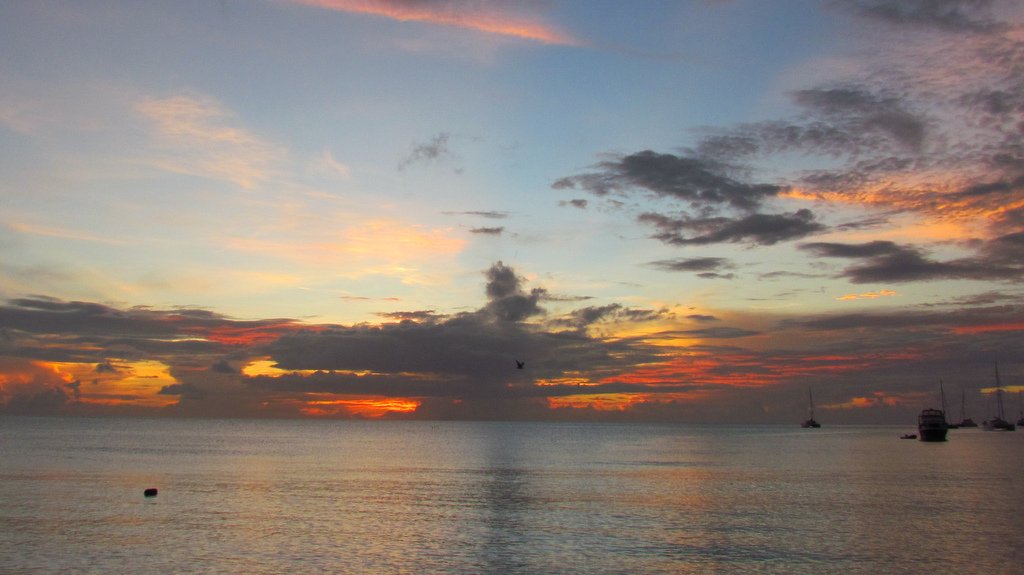