|
|
For the most recent reports from Antigua see this page.
- - - 2017 Hurricane Season - - -
|
- Irma to pass very close.
|
- By Martha Watkins Gilkes <marthawatkinsgilkes at gmail.com>
- Date: Mon, 4 Sep 2017 12:47:49 -0400
|
Image: How Close Can it Get for Antigua
Sent from my iPad
|
|
- HURRICANE ERMA AND ANTIGUA & Barbuda
|
- By Martha Watkins Gilkes <marthawatkinsgilkes at gmail.com>
- Date: Mon, 4 Sep 2017 12:11:29 -0400
|
TODAY THINGS  LOOK  VERY  BAD for  us as  it looks like the hurricane is coming
 directly  towards us….  We keep hoping for that   TURN  back out to sea   but
so far   it has not happened.. It is a  beautiful day today   but   by
tomorrow afternoon things  will start to  get  bad.    There is a  big
hurricane  rush  now.. I  try NOT TO HAVE  TO GO  DO LAST MIN  SHOPPING  but
am about  to do that  now  just  to BE SURE .

MORE  later..
|
|
- IRMA ---the meaning.. "WAR GODDESS"
|
- By Martha Watkins Gilkes <marthawatkinsgilkes at gmail.com>
- Date: Sun, 3 Sep 2017 21:52:05 -0400
|
|
|
|
- ANTIGUA & BARBUDA ON HURRICANE WATCH
|
- By Martha Watkins Gilkes <marthawatkinsgilkes at gmail.com>
- Date: Sun, 3 Sep 2017 17:15:02 -0400
|
Unfortunately the forecasted track is a bit more south again, bringing Irma very close to the northern Leeward Islands. Closest Point of Approach This is as of now not a very big storm in size, but it is very powerful; it is expected to be a Category 4 storm by the time is reaches the islands and will grow in size as well. Tropical storm winds at that time extend outward to the south up to 100-150 miles, so well within reach.5:00PM Update: Hurricane watches posted for Antigua, Barbuda, Anguilla, Montserrat, St. Kitts, and Nevis, Saba, St. Eustatius, Sint Maarten/Saint Martin and Saint Barthelemy. New advisories show Closest Point of Approach for Anguilla 49 miles, St.Maarten 60 miles and Antigua 91 miles.Hurricane Irma Public Advisory
000
WTNT31 KNHC 032050
TCPAT1

BULLETIN
Hurricane Irma Advisory Number  18
NWS National Hurricane Center Miami FL       AL112017
500 PM AST Sun Sep 03 2017

...HURRICANE WATCHES ISSUED FOR PORTIONS OF THE LEEWARD ISLANDS...
...NOAA HURRICANE HUNTER AIRCRAFT EN ROUTE TO IRMA...


SUMMARY OF 500 PM AST...2100 UTC...INFORMATION
----------------------------------------------
LOCATION...17.6N 49.8W
ABOUT 790 MI...1275 KM E OF THE LEEWARD ISLANDS
MAXIMUM SUSTAINED WINDS...115 MPH...185 KM/H
PRESENT MOVEMENT...W OR 260 DEGREES AT 14 MPH...22 KM/H
MINIMUM CENTRAL PRESSURE...969 MB...28.62 INCHES


WATCHES AND WARNINGS
--------------------
CHANGES WITH THIS ADVISORY:

The government of Antigua has issued a Hurricane Watch for the
islands of Antigua, Barbuda, Anguilla, Montserrat, St. Kitts, and
Nevis.

The government of the Netherlands has issued a Hurricane Watch for
the islands of Saba, St. Eustatius, and Sint Maarten.

The government of France has issued a Hurricane Watch for St.
Martin and Saint Barthelemy.

SUMMARY OF WATCHES AND WARNINGS IN EFFECT:

A Hurricane Watch is in effect for...
* Antigua, Barbuda, Anguilla, Montserrat, St. Kitts, and Nevis
* Saba, St. Eustatius, and Sint Maarten
* Saint Martin and Saint Barthelemy

Interests in the remainder of the Leeward Islands, the British and
U.S. Virgin Islands, and Puerto Rico should monitor the progress of
Irma.  Additional Hurricane and Tropical Storm Watches may be
required for portions of this area on Monday.

For storm information specific to your area, please monitor
products issued by your national meteorological service.


DISCUSSION AND 48-HOUR OUTLOOK
------------------------------
At 500 PM AST (2100 UTC), the center of Hurricane Irma was located
near latitude 17.6 North, longitude 49.8 West. Irma is moving toward
the west near 14 mph (22 km/h).  A westward to west-southwestward
motion with some reduction in forward speed is expected through
Monday night.  On the forecast track, the center of Irma is
forecast to approach the northern Leeward Islands late Tuesday.

Maximum sustained winds are near 115 mph (185 km/h) with higher
gusts.  Irma is a category 3 hurricane on the Saffir-Simpson
Hurricane Wind Scale.  Some strengthening is forecast during the
next 48 hours.

Hurricane-force winds extend outward up to 35 miles (55 km) from the
center and tropical-storm-force winds extend outward up to 140 miles
(220 km).

The estimated minimum central pressure is 969 mb (28.62 inches).


HAZARDS AFFECTING LAND
----------------------
WIND:  Hurricane conditions are possible within the watch area by
Tuesday night, with tropical storm conditions possible by late
Tuesday.


NEXT ADVISORY
-------------
Next intermediate advisory at 800 PM AST.
Next complete advisory at 1100 PM AST.
|
|
|
- HURRICANE IRMA
|
- By Martha Watkins Gilkes <marthawatkinsgilkes at gmail.com>
- Date: Sun, 3 Sep 2017 16:04:34 -0400
|
Hurricane Hunters will be flying into Irma as soon as she crosses over the 55W mark and we will definitely have a better picture ( as the info to date is from SATELLITE and not the Hurricane hunters drop sonde which is more accurate ) but the general consensus is for slow development from the 110 mph she is now to a Cat 4 at 130 mph. This is due to moving over very ripe warmer waters which is a hurricanes fuel source, a better moisture envelope surrounding her and very weak wind shear.
The Hurricane Hunters Plan of the day is below.. which means they will start flying IRMA TOMORROW Monday September 4th 230 p.m so we will have much better info after this as the info from the Satellite ( which is what we have info on so far) is not as accurate as the data from the HURRICANE HUNTERS !
Plan of the Day
000
NOUS42 KNHC 031621
REPRPD
WEATHER RECONNAISSANCE FLIGHTS
CARCAH, NATIONAL HURRICANE CENTER, MIAMI, FL.
1220 PM EDT SUN 03 SEPTEMBER 2017
SUBJECT: TROPICAL CYCLONE PLAN OF THE DAY (TCPOD)
         VALID 04/1100Z TO 05/1100Z SEPTEMBER 2017
         TCPOD NUMBER.....17-094

I.  ATLANTIC REQUIREMENTS
    1. HURRICANE IRMA
       FLIGHT ONE -- TEAL 74         FLIGHT TWO -- NOAA 49
       A. 04/1730Z                   A. 05/0000Z
       B. AFXXX 0311A IRMA           B. NOAA9 0411A IRMA
       C. 04/1430Z                   C. 04/1730Z
       D. 16.5N 53.2W                D. NA
       E. 04/1700Z TO 04/2030Z       E. NA
       F. SFC TO 15,000 FT           F. 41,000 TO 45,000 FT

       FLIGHT THREE -- NOAA 42       FLIGHT FOUR -- TEAL 75
       A. 04/2100Z                   A. 04/2330Z,05/0530Z
       B  NOAA2 0511A IRMA           B. AFXXX 0611A IRMA
       C. 04/2000Z                   C. 04/2045Z
       D. 16.4N 53.9W                D. 16.1N 54.3W
       E. 04/2045Z TO 05/0200Z       E. 04/2300Z TO 05/0530Z
       F. SFC TO 15,000 FT           F. SFC TO 15,000 FT

       FLIGHT FIVE -- NOAA 42        FLIGHT SIX -- TEAL 76
       A. 05/0900Z                   A. 05/1130Z,05/1730Z
       B  NOAA2 0711A IRMA           B. AFXXX 0811A IRMA
       C. 05/0800Z                   C. 05/0915Z
       D. 16.6N 56.2W                D. 16.7N 56.6W
       E. 05/0845Z TO 05/1400Z       E. 05/1100Z TO 05/1730Z
       F. SFC TO 15,000 FT           F. SFC TO 15,000 FT

    2. SUCCEEDING DAY OUTLOOK:
       A. CONTINUE C-130 6-HRLY FIXES ON IRMA.
       B. A NOAA 49 G-IV SYNOPTIC SURVEILLANCE MISSION AROUND IRMA
          FOR 06/0000Z, DEPARTING TBPB AT 05/1730Z.
       C. PROBABLE NOAA 42 P-3 TAIL DOPPLER RADAR MISSION INTO IRMA,
          DEPARTING TBPB AT 05/2000Z.
|
|
|
- HURRICANE IRMA AND ANTIUGA
|
- By Martha Watkins Gilkes <marthawatkinsgilkes at gmail.com>
- Date: Sun, 3 Sep 2017 15:14:38 -0400
|
PEOPLE are taking this very serious and doing lots of “getting ready. GOOD THING. The Electricity guys have been tree trimming all over the island ( GOOD THING) and there is lots of educational info TV and radio for the public ( GOOD THING). We think Antigua will have SIGNIFICANT impact PROBABLY AS A CAT. 4 HURRICANE.. very serious NOT A GOOD THING! Statement from out MET office TodayTROPICAL CYCLONE INFORMATION STATEMENTWHCA31 TAPA
TROPICAL CYCLONE INFORMATION STATEMENT
ANTIGUA AND BARBUDA METEOROLOGICAL SERVICES
6:00 AM ECT SUN, SEP 3, 2017 THIS IS FOR THE LEEWARD ISLANDS AND BRITISH VIRGIN ISLANDS ANTIGUA AND BARBUDA METEOROLOGICAL SERVICES IS CLOSELY FOLLOWING THE PROGRESS OF HURRICANE IRMA LOCATED ABOUT 945 MILES EAST OF THE LEEWARD ISLANDS. IRMA HAS ONCE AGAIN RETURNED TO CATEGORY 3 STATUS WITH MAXIMUM SUSTAINED WINDS NEAR 115 MPH AND IS FORECAST TO STRENGTHEN FURTHER. BASED ON THE LATEST INFORMATION, IRMA IS MOVING WEST-SOUTHWEST NEAR 15 MPH, AND THIS MOTION AT A SLIGHTLY SLOWER FORWARD SPEED IS EXPECTED THROUGH TONIGHT. A TURN TOWARDS THE WEST IS FORECAST ON MONDAY. IF IRMA HOLDS CLOSELY TO THE FORECAST TRACK, THE ISLANDS WILL BE SPARED MOST OF THE DANGEROUS WEATHER ASSOCIATED WITH THE SYSTEM. HOWEVER, IF AFTER TURNING WEST-SOUTHWEST IT DOES NOT RETURN TO THE WEST-NORTHWEST TRACK, VERY HAZARDOUS WEATHER WILL IMPACT THE AREA ON WEDNESDAY. TROPICAL CYCLONE WATCHES AND WARNINGS WILL LIKELY BE ISSUED LATER TODAY AND MONDAY RESPECTIVELY. RESIDENTS ARE URGED TO CONTINUE TO MONITOR IRMA AND BE PREPARED TO EXECUTE THEIR HURRICANE PLANS IF A WARNING IS REQUIRED ON MONDAY. FORECASTER
LETITIA HUMPHREYS/DALE DESTIN |
|
|
- Impending Irma 2
|
- By Ronn D <ninklennor at gmail.com>
- Date: Sun, 3 Sep 2017 08:45:41 -0400
|
Most of those highlighted models have a Cat 4 making land in their latest runs... What is for sure is the present trend of shifting closer to us with each new update.
A word to the wise, 'Pray for peace but prepare for war!' Attachment:
IMG-20170903-WA0004.jpg
Description: JPEG image
Attachment:
IMG-20170903-WA0005.jpg
Description: JPEG image
|
|
- WORTH WATCHING TO UNDERSTAND IRMA
|
- By Martha Watkins Gilkes <marthawatkinsgilkes at gmail.com>
- Date: Sat, 2 Sep 2017 20:15:16 -0400
|
https://www.tropicaltidbits.com
|
|
- HURRICANE IRMA LOOKING BAD
|
- By Martha Watkins Gilkes <marthawatkinsgilkes at gmail.com>
- Date: Fri, 1 Sep 2017 12:50:45 -0400
|
Our met office has just put this out. Very concerning.. WE may be in for a bad time !
TROPICAL CYCLONE INFORMATION STATEMENTWHCA31 TAPA
TROPICAL CYCLONE INFORMATION STATEMENT
ANTIGUA AND BARBUDA METEOROLOGICAL SERVICES
12:00 PM ECT FRI, SEP 1, 2017 THIS IS FOR THE LEEWARD ISLANDS AND BRITISH VIRGIN ISLANDS ANTIGUA AND BARBUDA METEOROLOGICAL SERVICES IS FOLLOWING THE PROGRESS OF HURRICANE IRMA LOCATED AROUND 1580 MILE EAST OF THE LEEWARD ISLANDS. BASED ON THE LATEST INFORMATION, IRMA IS FORECAST TO MAKE AN UNUSUAL TURN TO THE WEST-SOUTHWEST ON SATURDAY BEFORE TURNING WESTWARDS ON SUNDAY AND THIS COULD INCREASE THE THREAT TO THE ISLANDS. WHILE NO ACTION IS REQUIRED AT THIS TIME, RESIDENT ARE STRONGLY URGED TO CONTINUE TO MONITOR THE PROGRESS OF THIS SYSTEM VERY CLOSELY FORECASTER LENARD JOSIAH |
|
|
- Impending Irma
|
- By Ronn D <ninklennor at gmail.com>
- Date: Fri, 1 Sep 2017 10:25:42 -0400
|
Hi Guys,
The days have actually gotten cooler over the past week or two after weeks of energy sapping heat. Now Irma looms several days away with no definite certainty on the path that she will take.
We here locally continue to hope and pray for the best after being spared any major hits for several years. However we are urged to be prepared for the worst while hoping for the best; for sure the 'good' rain showers are always welcomed here on our 'prone to be dry' but lovely bit of paradise.
While we pray for Texas let's also keep ourselves prepared for anything and everything.
Regards, Ronn Attachment:
IMG_20170901_102007.jpg
Description: JPEG image
|
|
- Irma la douce
|
- By "John Fuller" <fullaw at candw.ag>
- Date: Thu, 31 Aug 2017 16:53:58 -0400
|
The boys in the backroom are stirring
|
|
|
- HURRICANE IRMA
|
- By Martha Watkins Gilkes <marthawatkinsgilkes at gmail.com>
- Date: Thu, 31 Aug 2017 14:44:22 -0400
|
TODAY Hurricane Irma developed in the Atlantic and our islands ( the northern leewards) are in the projected path. It is forecast to become a MAJOR HURRICANE.. perhaps a Category 4... This is a very dangerous potential hurricane. Our island of Antigua has been spared for a number of years now and I prayed i would NEVER SEE ANOTHER CATAGORY 4 Hurricane again ( Hurricane Luis hit us here as a CAT 4 and there was major devastation ) It is still a BIT too early to tell and we hope the path will shift to the NORTH but this one bears serious watching and to be ready to implement our major hurricane preparedness plan. The next few days will certainly be about being HURRICANE READY and we will try to keep those who are STORM CARIB watchers up to date on what is happening.
|
|
|
- Hurricane Irma
|
- By Daniella Seepaul <daniellaseepaul at gmail.com>
- Date: Thu, 31 Aug 2017 11:45:03 -0400
|
Hi Islanders,
With Hurricane Irma looming over the eastern Atlantic, forecast models warn of a potential and uncharacteristic South-West dip on approaching the Leeward Islands, along with the likelihood of intensifying into major hurricane.
Now is the time we should all monitor and prepare, in the event that Hurricane Irma makes it's way over to us. Be prepared, Be Safe.
Regards,
Daniella Seepaul
|
|
- Weather watching this week and Houston
|
- By Martha Watkins Gilkes <marthawatkinsgilkes at gmail.com>
- Date: Mon, 28 Aug 2017 05:06:00 -0400
|
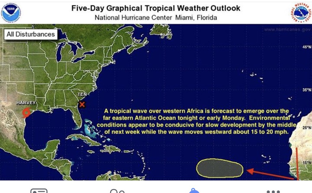
What a terrible disaster for Texas. Thinking of all these here.
Martha Watkins Gilkes
P.O. Box W1924
Antigua, West Indies
268 460 4423
Cell 2687647722
Sent from my  fab iPhone
Marthawatkinsgilkes at gmail.com
|
|
- Systems in the Caribbean
|
- By Martha Watkins Gilkes <marthawatkinsgilkes at gmail.com>
- Date: Thu, 17 Aug 2017 19:36:06 -0400
|
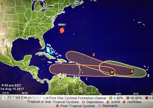
We are watching.   Especially 92L.   It is the season.
  Have to stay alert
Martha Watkins Gilkes
P.O. Box W1924
Antigua, West Indies
268 460 4423
Cell 2687647722
Sent from my  fab iPhone
Marthawatkinsgilkes at gmail.com
|
|
- Busy Season
|
- By Daniella Seepaul <daniellaseepaul at gmail.com>
- Date: Tue, 15 Aug 2017 18:09:43 -0400
|
Hi Fellow Islanders,
With a series of potential storms on the horizon; 91L, 92L,
and another that’s about to leave the West coast of Africa it's evident that
this season will be a busy one. Watching 91L closely as some models indicate it
passing somewhere close or over the Lesser Antilles, and over to the Caribbean Sea,
whilst after 92L and possibly future 93L tread across the Atlantic Ocean, it's
a bit too early to predict its future track.
This is the time when we should all be prepared, making sure
all is storm and possibly hurricane ready as we now enter the peak phase of the
season.
Always be prepared.
Regards.
Daniella Seepaul
|
|
- Watching a new wave
|
- By Martha Watkins Gilkes <marthawatkinsgilkes at gmail.com>
- Date: Thu, 27 Jul 2017 05:41:15 -0400
|
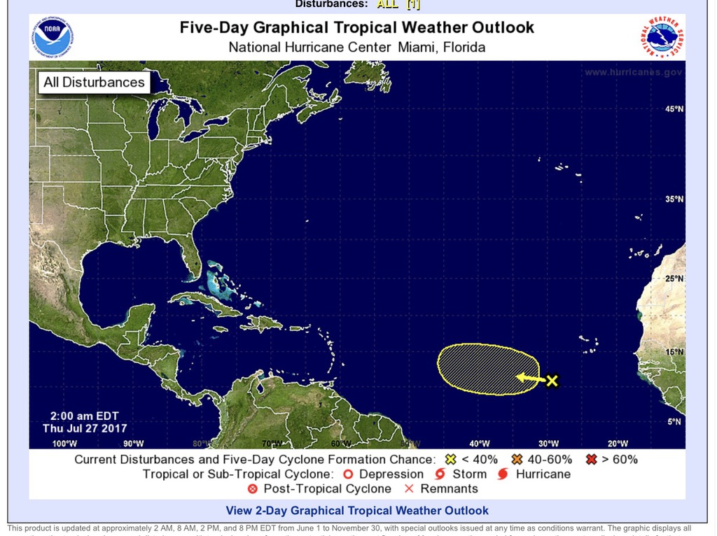
This just coming our way.  Worth watching.
Will be slow developing  but seems more on a track near Antigua.
|
|
- Storm Don in the Windward islands.
|
- By Martha Watkins Gilkes <marthawatkinsgilkes at gmail.com>
- Date: Tue, 18 Jul 2017 07:01:08 -0400
|
|
|
|
- Weather developing.
|
- By Martha Watkins Gilkes <marthawatkinsgilkes at gmail.com>
- Date: Mon, 17 Jul 2017 17:46:27 -0400
|
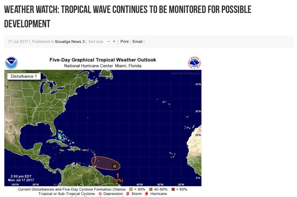
this will most likely stay south.
|
|
- Weather watching
|
- By Martha Watkins Gilkes <marthawatkinsgilkes at gmail.com>
- Date: Sun, 16 Jul 2017 10:28:08 -0400
|
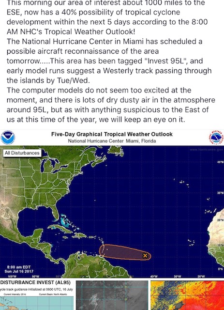
As shared by Steve coglan on another weather site. Need to keep an eye on this.
 Looks like it will stay south.
|
|
- Update
|
- By Johnefuller <johnefuller at gmail.com>
- Date: Sun, 9 Jul 2017 19:25:39 -0400
|
Sent from my iPhone
|
|
- Update
|
- By Johnefuller <johnefuller at gmail.com>
- Date: Fri, 7 Jul 2017 20:16:19 -0400
|
Sent from my iPhone
|
|
- Alert to closely monitor TD 4
|
- By Daniella Seepaul <daniellaseepaul at gmail.com>
- Date: Thu, 6 Jul 2017 08:50:46 -0400
|
Hello fellow Islanders, With TD 4 out in the Atlantic located at 13.2N and 40.0W, the Antigua met office have issued an alert statement for the Leeward Islands & British Virgin Islands to monitor TD 4 closely, http://fb.me/44SLCZ5z0.
Regards,
Daniella Seepaul |
|
- HAPPY TO SEE THIS PROJECTED PATH
|
- By Martha Watkins Gilkes <marthawatkinsgilkes at gmail.com>
- Date: Wed, 5 Jul 2017 21:27:32 -0400
|
| LOOKS LIKE we will be lucky in the islands if this projected path stays on course! Don’t wish an early season storm! |
|
|
- WATCHING THE FIRST OF THE SEASON
|
- By Martha Watkins Gilkes <marthawatkinsgilkes at gmail.com>
- Date: Tue, 4 Jul 2017 09:50:00 -0400
|
| IT IS EARLY in the hurricane season for us to be watching but 94L seems worth watching…. hopefully it will pass to the north over the next few days but as we know weather is always unknown so this is a good heads up for us !
|
|
|
- Things Seems to be Starting!
|
- By Daniella Seepaul <daniellaseepaul at gmail.com>
- Date: Wed, 14 Jun 2017 12:03:22 -0400
|
Hi Fellow Islanders,
It seems to be the very start of things for the 2017 hurricane season not withholding the very first storm Arlene has come and gone since April. Now looking out at the Atlantic we can see a series of tropical waves one of which has a 20% chance of developing into a tropical cyclone within the next 5 days according to the National Hurricane Center.
Presently the weather here in Antigua is beautiful, we're experiencing a lovely easterly breeze and slightly overcast skies, a perfect beach day. Enjoying the weather but keeping an eye out at the Atlantic, remember it only takes one.
Be prepared, be vigilant!
Regards, Daniella Seepaul
|
|
- Safe 2017
|
- By Daniella Seepaul <daniellaseepaul at gmail.com>
- Date: Wed, 18 Jan 2017 08:01:27 -0400
|
Hi,
Happy New Year to all islanders. Here's to a safe hurricane season for 2017. Remember it's never to early to be prepared.
Regard,
Daniella Seepaul |
|


