|
|
- - - 2012 Hurricane Season - - -
|
- ? Suspicious (last) approachment ?
|
- From: Ian Martin Borde <readkrox51 at gmail.com>
- Date: Fri, 29 Mar 2013 14:53:38 -0400
|
People of Paradise,
~* HAPPY EASTER *~ I hope we are wrong but there seems to be a last approachment of high seas. (see attached) I also guesstimate we should get more rainy weather in two and a half (2 1/2) days, ....
Keep fingers and toes crossed. It's the season for it. Hallelujah 
|
|
- Aside -
|
- From: Ian Martin Borde <readkrox51 at gmail.com>
- Date: Tue, 19 Mar 2013 03:42:29 -0400
|
This is a little interesting aside.
(The reason we are posting is because it's not little and done in the most tasteful way possible by EMMINENT Individuals, ....) : Dr. Myneni's petition to protect Earth from climate change
Professor
Myneni of Boston University's Department of Earth & Environment,
co-author of the greening Arctic study, has developed a simple
one-sentence petition that he hopes one billion people will sign by
Earth Day, 2014:
Dear Secretary-General of the United Nations Ban Ki-moon,
We,
the People of the Earth, request You to act judiciously and
expeditiously to protect the Earth from anthropogenic climate change.
Respectfully,
People of the Earth
The petition, which I have signed, is at: https://yourclimatechange.org/, and was recently featured by Discovery News.
Jeff Masters |
|
- Latest Information Bulletin from the T and T Met Office re big swells at the weekend:
|
- From: Katy Young <katy at sbms.co.tt>
- Date: Thu, 7 Mar 2013 09:27:51 -0500
|
Latest Information Bulletin from the T and T Met Office re big swells at the weekend:
Date: Wednesday 06th of March 2013
ISSUED AT:02:19PM
LONG PERIOD SWELLS FORECAST TO AFFECT TRINIDAD AND
TOBAGO OVER THE WEEKEND
Sea conditions being experienced around Trinidad
and Tobago are currently normal with waves
peaking at 2 metres. However, Numerical Weather
Prediction (NWP) Models are forecasting sea
conditions to change over the next four days.
This is attributed to swells generated by the
passage of a frontal system associated with a Low
Pressure System presently in the Western Atlantic.
These swells are forecast to propagate to the
Eastern Caribbean by Saturday 9th March 2013 and
affect exposed coastlines of Trinidad and Tobago
as early as midday on Sunday 10th March 2013.
NWP models forecast wave heights to be in excess
of 2.5 metres, with long periods between wave
crests by Sunday 10th March 2013. These long
periods will render seas hazardous particularly
along exposed coasts in Trinidad and Tobago.
Tobago will experience the effects earlier than
Trinidad.
Citizens in general, and those residing along
coastal areas, are asked to be on the alert for
above normal sea conditions. All necessary
measures MUST be taken to preserve life and
property.
SMALL CRAFT OPERATORS, SEA BATHERS AND ALL MARINE
INTERESTS ARE ASKED TO EXERCISE EXTRA CAUTION IN
ANY SEA RELATED ACTIVITIES.
The Trinidad and Tobago Meteorological Service
(TTMS) is continuing to closely monitor weather
conditions and the impacts on sea conditions.
This bulletin serves as information only and the
TTMS will issue a Rough Seas bulletin pending
confirmed reports of deteriorating sea conditions
in the Northern Caribbean Sea.
Arlene Aaron
Meteorologist
--
Katy Young
Director

Store
Bay Marine Services Limited
Unit
B, Bago's
Beach Bar, Pigeon
Point Road,Crown
Point, Tobago
Mailing
Address: PO
Box 130,
Scarborough, Tobago
Website:
www.sbms.co.tt
Email: katy at sbms.co.tt
Phone:
660
8468 Cell: 740 2269 VHF:
Ch06 Facebook: Store Bay Marine Services:https://www.facebook.com/StoreBayMarineServicesTobago
Directors:
John
R Stickland & Katy Young
|
|
- Update on swells forecast for Trinidad and Tobago
|
- From: Katy Young <katy at sbms.co.tt>
- Date: Wed, 6 Mar 2013 13:42:27 -0500
|
Update from the Office of Disaster Prepardness and Management Trinidad and Tobago
Long period swells forecast to affect Trinidad and Tobago over the weekend
Sea conditions being experienced around Trinidad and Tobago are
currently normal with waves peaking at 2 metres. However, Numerical
Weather Prediction (NWP) Models are forecasting sea conditions to change
over the next four days. This is attributed to swells generated by the
passage of a frontal system associated with a Low Pressure System
presently in the Western Atlantic. These swells are forecast to
propagate to the Eastern Caribbean by Saturday 9th March 2013 and affect
exposed coastlines of Trinidad and Tobago as early as midday on Sunday
10th March 2013.
NWP models forecast wave heights to be in
excess of 2.5 metres, with long periods between wave crests by Sunday
10th March 2013. These long periods will render seas hazardous
particularly along exposed coasts in Trinidad and Tobago. Tobago will
experience the effects earlier than Trinidad.
Citizens in general, and those residing along coastal areas, are asked
to be on on the alert of above normal sea conditions. All necessary
measures MUST be taken to preserve life and property.
SMALL CRAFT OPERATORS, SEA BATHERS AND ALL MARINE INTERESTS ARE ASKED TO EXERCISE EXTRA CAUTION IN ANY SEA RELATED ACTIVITIES.
The Trinidad and Tobago Meteorological Service and ODPM are closely
monitoring the situation. This bulletin serves as information only and a
Rough Seas Bulletin will be issued pending confirmed reports only.Have a good afternoon
Katy
--
Katy Young
Director
Store
Bay Marine Services Limited
Unit
B, Bago's
Beach Bar, Pigeon
Point Road,Crown
Point, Tobago
Mailing
Address: PO
Box 130,
Scarborough, Tobago
Website:
www.sbms.co.tt
Email: katy at sbms.co.tt
Phone:
660
8468 Cell: 740 2269 VHF:
Ch06 Facebook: Store Bay Marine Services:https://www.facebook.com/StoreBayMarineServicesTobago
Directors:
John
R Stickland & Katy Young
|
|
- Swells forecast for Trinidad and Tobago
|
- From: Katy Young <katy at sbms.co.tt>
- Date: Wed, 6 Mar 2013 07:26:57 -0500
|
Morning All,
It is only Wednesday but it is worth keeping an eye on the forecast for swells for the north coast of Trinidad and Tobago which are expected to materialise on Sunday and last throughout the following week. At the moment WindGuru is forecasting a change in wave direction on Sunday from E to NNE, wave periods will increase from 7 second intervals to up to 17 second intervals on Tuesday. The wave height will build from 1.6m to around 2.6m on Monday/Tuesday and it is predicted that the swell will start dropping off around Thursday. Luckily the wind is not really picking up - just a max of 19 knot gusts on Monday/Tuesday.
As yet no warnings have been issued by the Trinidad and Tobago Met Office.
Will keep you updated as and when information is available.
Best wishes and have a good day
Katy
--
Katy Young
Director
Store
Bay Marine Services Limited
Unit
B, Bago's
Beach Bar, Pigeon
Point Road,Crown
Point, Tobago
Mailing
Address: PO
Box 130,
Scarborough, Tobago
Website:
www.sbms.co.tt
Email: katy at sbms.co.tt
Phone:
660
8468 Cell: 740 2269 VHF:
Ch06 Facebook: Store Bay Marine Services: https://www.facebook.com/StoreBayMarineServicesTobago
Directors:
John
R Stickland, Rajesh
Singh & Katy
Young
Attachment:
Synopsis by the Trinidad and Tobago Surfing Association.jpg
Description: JPEG image
|
|
- The Closing Winter, ..., The already Dry Spring
|
- From: Ian Martin Borde <readkrox51 at gmail.com>
- Date: Thu, 28 Feb 2013 14:07:48 -0400
|
2013 - 02 - 28th. Thu.
13 : 46 (1:46) p.m. P/Vly, D'go M'rtn, T&T, W.I. Good Day, Good Everything, (fair-weather), People of Paradise,
I am seriously thinking of taking a week-end trip (the cheapest) and visit each island one-by-one, this dry season. [Joke: With these winds, we'll (my daughter and I) will probably do it in record time and lose weight and nerves.] How is the basking in the sun and sipping pine-coladas going? Aren't the nights, these romantically cold-and-comfy nights, as child-creating as you can get? Well, suenos, back to work, ....
Just a short update: A STRONGER COLD FRONT CURRENTLY IN THE GULF OF MEXICO
WILL ENTER THE W ATLC EARLY SAT
AND MERGE WITH STATIONARY FRONT SUN.
STRONG TO NEAR GALE W TO NW WINDS WILL SPREAD ACROSS
ENTIRE BASIN SUN INTO MON. That's NHC's take, my own is; - Higher Seas - Stronger winds - Colder nights from tonight, .... God bless |
|
- Carnival Shake Up
|
- From: Ian Martin Borde <readkrox51 at gmail.com>
- Date: Sun, 10 Feb 2013 21:00:38 -0400
|
2013-02-10th. Sun.
20:20 (8:20) p.m. T&T, W.I. Comment ca va, Carnival Partying, People of Paradise, (& the small brown dog, ... :)
I guess, you guessed? But we can write a lot more if the time and the forum would have permitted. So, my dear guardians of Paradise, please write more often and do whatever to financially sustain this website.
The ruling party lost the 'local' elections completely in the sister isle of Tobago. And as if a pressure valve was released the satirical (and critical) calypsoes and atmosphere of Carnival bore a much greater weight than usual.
The 'Pink Panther (King Panther)' won Calypso Monarch. Machel Montano and Austin ' Superblue' Lyons, (the student and master of Road March), won in a tie the Soca Monarch. 
The Junior Kiddies' Carnival, 'Parade of Bands' has come to the end, with the explosive win of Petrotrin Phase II (two), steel orchestra in the greatest 'savannah party' the world has to offer.
We will need a mega-drive to express the King and Queen of The Bands as they were all winners.
Attached is the 5.0 earthquake we experienced as the weather continues to fog up the place.
Bailan mis amores
Dance de Carnival
Attachment:
10th feb t&t.jpg
Description: JPEG image
|
|
- Another Approachment tonight, (onwards), ....
|
- From: Ian Martin Borde <readkrox51 at gmail.com>
- Date: Fri, 1 Feb 2013 06:47:16 -0400
|
Busy and Late, but posting that NHC issued a high seas forecast that you should read, ....
Do not be wrong and strong, You will be humbled by Nature, God bless
|
|
- Pleasant unpleasantness, ....
|
- From: Ian Martin Borde <readkrox51 at gmail.com>
- Date: Mon, 28 Jan 2013 15:38:41 -0400
|
2013 - 01 - 28 Mon.
15:30 (3:30) p.m. T&T, W.I. There we go! Isn't that bad after all. The chill and light rain and large swells, with refreshing southerly trades, .... (Can't say the same for pressure and humidity)! Even body-surfed a eight (8 ft.) foot wave, ....
All in Nature's restoration process. Note: By the way The ITCZ has gone its limit to the south. Any time now it will start coming back up to 10 N. Latitude. God is restoring and blessing us,
God bless |
|
- We know, we know very little, ....
|
- From: Ian Martin Borde <readkrox51 at gmail.com>
- Date: Mon, 21 Jan 2013 18:05:03 -0400
|
From tonight, some sort of (small scale) weather phenomenon will affect us, esp. Puerto Rico.
It might even be pleasant.A WEAK UPPER TROUGH IS SANDWICHED BETWEEN THE TWO UPPER RIDGES
NEAR 30W. THE UPPER TROUGH IS CAUSING NO ACTIVE WEATHER IN THE
DISCUSSION AREA. HOWEVER...IT IS SUPPORTING A FRONTAL BOUNDARY
THAT EXTENDS THROUGH THE SURFACE RIDGE WITH AXIS JUST NORTH OF
THE AREA NEAR 31N. THE FRONT WILL LIKELY DIP SOUTH INTO THE AREA
SHORTLY. |
|
- Another COLD 'Approachment' - 3 - 7 days -
|
- From: Ian Martin Borde <readkrox51 at gmail.com>
- Date: Fri, 18 Jan 2013 04:46:21 -0400
|
A 1015 MB SURFACE LOW IS
ANALYZED NEAR 20N41W WITH A SURFACE TROUGH TO THE E ALONG 22N39W
19N38W TO 13N45W. SCATTERED SHOWERS ARE FROM 18N-22N BETWEEN
37W-42W. A BROAD SURFACE RIDGE COVERS THE ATLC E OF 70W WITH A
WEAKNESS IN THE IMMEDIATE VICINITY OF THE ABOVE SURFACE TROUGH
AND ANCHORED BY A 1026 MB HIGH IN THE W ATLC NEAR 32N56W AND
1026 MB HIGH IN THE E ATLC NEAR 32N19W. THE COLD FRONT WILL
EXTEND FROM BERMUDA TO CENTRAL CUBA ON FRI EVENING THEN STALL
FROM 32N58W TO CENTRAL CUBA SAT. REMNANTS OF THE FRONT WILL
RETURN NW THROUGH THE NORTHERN BAHAMAS ON SUN THEN MOVE SE AGAIN
ON MON AND TUE.
God bless
|
|
- Atlantic Blizzard -
|
- From: Ian Martin Borde <readkrox51 at gmail.com>
- Date: Tue, 15 Jan 2013 17:33:48 -0400
|
Happy New Year, People of Paradise,
Taking Note
There appears to be an 'Atlantic Blizzard' that is too well formed (after traveling) and too far south for Equatorial comfort. Already Los Angeles and Jerusalem had heavy snowfall, .... Which is like a one in twenty year phenomenon.
Yesterday Monday, beginning at dawn, three (3m.) metre swells damaged and destroyed small marine crafts on the north coast of Tobago.
I attach two pictures that represent how the climate has stepped up its activity.
Keep safe and sound, (Carnival fetes are underway, ....)
Attachment:
13th Jan - 1045 am.jpg
Description: JPEG image
Attachment:
14th jan - 2400am.gif
Description: GIF image
|
|
- Qu. : Is this NORMAL?
|
- From: Ian Martin Borde <readkrox51 at gmail.com>
- Date: Sun, 6 Jan 2013 23:55:49 -0400
|
2013 - 01 - 06 Sun.
23:30 (11:30) p.m. T&T, W.I. At ten o'clock tonight the temperature in Petit Valley, Diego Martin was 75 F. One can never be sure but apparently the last two days around 3:00 a.m. the temperatures dipped to 74 F. Convection, ie. slight rainfall with slight (<15mph.) winds occurred the last two days as well.
Believe me, nobody's complaining! For our reference, the foll. applies: A 1026 MB HIGH IS OVER THE CENTRAL ATLANTIC NEAR 31N56W.
A COLD FRONT IS OVER THE E ATLANTIC FROM 32N30W TO 26N40W TO
25N60W. WIDELY SCATTERED MODERATE CONVECTION IS E OF THE FRONT N
OF 29N BETWEEN 23W-32W. SCATTERED SHOWERS ARE WITHIN 30 NM OF
THE REMAINDER OF THE FRONT. EXPECT IN 24 HOURS FOR A COLD FRONT
TO EXTEND FROM 32N67W TO S FLORIDA NEAR 27N80W WITH CONVECTION.
ALSO EXPECT THE E ATLANTIC FRONT TO CONTINUE TO MOVE E WITH
SHOWERS. Seas have been rough.
All this is not totally out of the ordinary for 'winter-weather' but guesstimating, there is less than 13% variance each year to colder nights and higher seas. As I said one can only guess while pulling on a sweater or track-top and then diving under the covers.
If you have not booked your costume and plane-ticket for the T'dad Carnival you are advised not to tarry any longer. Carnival is early this year ie. 11th. February 2013 Let the fun begin, ....
|
|
- Something - New - in the old year !
|
- From: Ian Martin Borde <readkrox51 at gmail.com>
- Date: Thu, 27 Dec 2012 01:25:48 -0400
|
Good Day, Good Everything, People of Paradise,
Never thought we would post outside the season about something outside the tropics, .... But, here goes;
Each time a cold front (of magnitude) leaves the east coast (of USA) (ie. tomorrow night,) we in the Caribbean (Eastern Caribbean - Lesser Antilles) from now on can expect, .... 1) Night time temperatures of 25C or less for more than 4 hours.
2) Overcast skies (possibly white-outs) for almost half-day. (with convection). 3) Gusty winds and seas. (Ideal for windsurfing). Though sporadic. Now why is this worthy of posting, ..., because vehicles and heavy machinery have little or no traction in those conditions!
- It's a new thing - God bless |
|
- Highs and Lows of a Northern-Winter Christmas
|
- From: Ian Martin Borde <readkrox51 at gmail.com>
- Date: Mon, 24 Dec 2012 03:38:47 -0400
|
2012 - 12 - 24th. Mon.
03 : 20 a.m. P/Vly, D'go, T&T, W.I.
Without the snow and frost, (and a few other things), it appears to me that we have a frontal clash right here in The Trinidad Triangle, ....
If the attached photos are delivered it is plainly obvious what I'm talking about, ....
Two other things;
The not so good is that the Mayan Calendar really meant Dec. 24th. (in 'real' time).
The very good is that 'The Spirit of Christmas' is here and "WOW!" What a great time to be alive and living in The West Indies, ....
Merry Christmas
Attachment:
24th dec 120am christmas eve.jpg
Description: JPEG image
Attachment:
24th dec - Christmas Eve.jpg
Description: JPEG image
Attachment:
24th dec Sea-temps Christmas Eve.jpg
Description: JPEG image
Attachment:
Mon 24th Dec - 117am 'Christmas Eve'.jpg
Description: JPEG image
Attachment:
Sea-state Christmas Eve.gif
Description: GIF image
|
|
- Finally (at XXI) - Enter the fat lady !
|
- From: Ian Martin Borde <readkrox51 at gmail.com>
- Date: Mon, 10 Dec 2012 16:02:04 -0400
|
2012 - 12 - 10 Mon.
15:50 - 3:50 p.m.
P/Vly, D'go,
T&T, W.I.
People of Paradise, Good Day, Good Everything,
Well what do you know?
The fat lady has sung her whole repertoire, and with some water in her eyes has moved on.
In my reckoning, and mine alone, the 'ITCZ' has now gone too far south and wind shear is too far west for any hurricane to develop. As well sea temps are 'normally' cool.
In addendum, "Anything, including fluctuations, are possible with modern day weather!"
More factually and collaborated, for T'dad & T'bgo, we can experience Southern Hemisphere 'Summer' rainfall in copious amount and an even smaller chance of flooding, ....
So let's all keep our cisterns well insulated. God bless, for God has truly blessed us here in Paradise.
Peace, Love and Blessings
Bro. Ian
|
|
- 3 days now, ....
|
- From: Ian Martin Borde <readkrox51 at gmail.com>
- Date: Sun, 2 Dec 2012 12:32:30 -0400
|
2012 - 12 - 02 Sun.
12 : 15 p.m.
P/Vly, D'go,
T&T, W.I.
Hi People of Paradise,
I am sure that we have all started to stock up on Christmas and New Year's libations (as men), while the women clean, decorate and cook, (with male help, of course), for the festive season of 'cheer and charity'.
Three days ago was the 'last' of the hurricane season.
A blob, if the attached pictures allow you to see, began giving us sustained showers, three days ago.
Somebody is clearly speaking the wrong language, to the wrong people about the wrong things. For if the hurricane season has finished. And we say, "Alleluia", then sustained showers should finish.
Just maybe, just a little maybe, now that there are definite signs that climate change, global warming, and small island vulnerability, (besides New Jersey), are not only in more focus, but have reached some 'objective and scientific' common ground. Then this rain and other weather will bring forth; apples, pears, oranges, bananas, paw-paw, nectarines, peaches, plums, cherries, golden - apple, soursop, barbadine, strawberries, blackberries, raspberries, cranberries,, ..., etc, .....
God bless
Attachment:
2nd Dec 745am.jpg
Description: JPEG image
Attachment:
2nd dec 1014am.jpg
Description: JPEG image
|
|
- Part XXI
|
- From: Ian Martin Borde <readkrox51 at gmail.com>
- Date: Sun, 25 Nov 2012 03:55:49 -0400
|
Part XXI is more than a passing cloud.

Fortunately, so far, she is an offshore phenomenon. When she comes
ashore she has nascent TD characteristics. This makes her a formidable
blob, esp. having survived this far, ....

THE SE CARIBBEAN S OF 14N
BETWEEN 60W-68W CONTINUES TO EXPERIENCE WIDELY SCATTERED SHOWERS
AND ISOLATED TSTMS AS WEAK SURFACE TROUGHING PROGRESSING
WESTWARD.


As they say in The Red Cross, "It is not 'Well done', till It's 'Done'."

Will the fat lady step forward and sing, please?

God bless
Attachment:
24th nov 1045pm.jpg
Description: JPEG image
Attachment:
sat 24th nov 445am.jpg
Description: JPEG image
Attachment:
usc000dxfa_ciim.jpg
Description: JPEG image
|
|
- Part XX, Sequel or Prodigy - Minor Impact
|
- From: Ian Martin Borde <readkrox51 at gmail.com>
- Date: Fri, 16 Nov 2012 13:14:31 -0400
|
Good Day, Good Everything, People of Paradise,
Trinidad & Tobago have had a minor impact for the last two hours. The reason for posting is because there is definitely more to come (within 36 hrs.).
Nothing with winds over 30 mph., Invest material or otherwise. But can be hazardous in localized ares.
Once again what we had was the tip and don't let the sunshine fool you into denial or complacency.
God bless
Attachment:
16th Nov 2012 1049 am.jpg
Description: JPEG image
|
|
- Post - Part XX
|
- From: Ian Martin Borde <readkrox51 at gmail.com>
- Date: Sat, 10 Nov 2012 10:20:14 -0400
|
Just a quick note:
(esp. for ABC Islands, Caymans and Belize)
A weak and injured Part XX affected Trinidad and Tobago from Wednesday to (slightly) this morning, 07:00 a.m. She should amount to nothing because of dry air and wind shear. However at times she will be worthy of being called Part XX. As she is capable of causing - heavy - minor street or flash flooding for a short and limited period.
She is small and her effects are short-lived.
God bless
|
|
- Another BEAUTIFUL DAY in Paradise
|
- From: Ian Martin Borde <readkrox51 at gmail.com>
- Date: Sun, 4 Nov 2012 15:48:19 -0400
|
Good Day, Good Everything, People of Paradise,
For Once in 2 1/2 years, the weather seems to give us what can be called normal days for over a week now!
Even the satellite loops have 'normal' jet streams, .... (Well almost).
"Nothing to report, Sir." Going back outside and sniff the fresh, tropical Sunday air, ....
God Bless
|
|
- (Possible - Part XX - ) 36 - 48 hours
|
- From: Ian Martin Borde <readkrox51 at gmail.com>
- Date: Sat, 27 Oct 2012 07:17:02 -0400
|
2012 - 10 - 27th. Sat.
06 : 50 a.m.
P/Vly, D'go,
T&T, W.I.
May all the SOULS and Casualties of Rafael and Sandy, find in The Name of The Most High, the COMFORT and PEACE that eluded them in this earthly life, ..., and may we, in respect and mercy to each other who have survived give thanks for the Light of Day, The Kiss of Gentle Breezes and Security and Comfort of Warm Weather Embraces!
In 36 - 48 hrs. The Lesser Antilles may possibly experience some sort of Impact (as per, NHC):
...TROPICAL WAVES...

AN ATLANTIC OCEAN TROPICAL WAVE IS ALONG 17N45W 13N44W 10N43W.
IT HAS BEEN MOVING WESTWARD 10 KNOTS DURING THE LAST 24 HOURS.
CONVECTIVE PRECIPITATION...SCATTERED MODERATE TO STRONG FROM
10N TO 14N BETWEEN 38W AND 43W.

AN ATLANTIC OCEAN TROPICAL WAVE IS ALONG 16N51W 13N49W 11N47W
MOVING WESTWARD 10 KNOTS DURING THE LAST 24 HOURS. CONVECTIVE
PRECIPITATION...ISOLATED MODERATE FROM 13N TO 16N BETWEEN 48W
AND 51W. AN UPPER LEVEL TROUGH PASSES THROUGH 32N46W TO 27N44W
22N43W TO 18N44W AND 16N46W. AN INVERTED MIDDLE LEVEL TO UPPER
LEVEL TROUGH IS ALONG 16N47W 14N49W 10N56W BEYOND SOUTHEASTERN
VENEZUELA. SCATTERED MODERATE TO ISOLATED STRONG CONVECTIVE
PRECIPITATION IS FROM 5N TO 8N BETWEEN 43W AND 47W.
THE TROUGHS ARE IN THE AREA OF THIS TROPICAL WAVE.
I would like to say that at the same time the US East Coast will receive storm surge Impact.
When we opened this web site today we saw Dave and Gert quoting on the first page, I endorse them and their quotation. Permit to add to it and say, "What we do on stormcarib.com is as important (and frightening) like dealing with a heart attack."
The vision of Walt Disney and 'animated cartoons' always run thru my mind in cutting off disaster in catastrophes. The character is running after some perception of comfort or rivalry and falls over a cliff that he never took account of.
Once again may their souls rest in Peace, ....
|
|
- Jamaica
|
- From: Jorge Abreu <jorgeabreu27 at hotmail.com>
- Date: Wed, 24 Oct 2012 09:14:03 -0400
|
|
Our thoughts and prayers are with the people of Jamaica as weather conditions begin to deteriorate over there. Strong Tropical Storm Sandy (almost hurricane strength now) continues on its projected path for a direct hit on the island later today. Special thanks to those correspondents who are able to keep us informed on conditions there today. Here in Port-of-Spain its partly overcast after some brief showers this morning, but we expect another very hot day (34-35C).
stay safe Jamaica,
Jorge Abreu
|
|
|
- - Unity & Solidarity, Forever -
|
- From: Ian Martin Borde <readkrox51 at gmail.com>
- Date: Tue, 23 Oct 2012 18:01:05 -0400
|
God Bless, each and every Jamaican tonight and in the following days, ....
Rest assured that in whatever capacity, (as individuals, Government, Private Sector, NGO's, Foreign Trade,) you are not alone in this storm.
Our hearts go out to you!
God bless,
Bro. Ian
|
|
- Update
|
- From: Christine Westmaas <chrisalis1003 at yahoo.co.uk>
- Date: Sat, 13 Oct 2012 13:20:41 +0100 (BST)
|
We had quite a bit of rain during the night and have awoken this morning to grey skies and a very comfortable temperature. The media are reporting that the heavy rains and the windy conditions affected mainly the east and south of Trinidad and the Caura River burst its banks. There have been reports of flash flooding in the east. CAL flights which were cancelled yesterday (Trinidad - Barbados) have been re-scheduled for today. |
|
- Latest on weather association with Tropical Storm Rafael
|
- From: Katy Young <katy at sbms.co.tt>
- Date: Sat, 13 Oct 2012 04:44:02 -0600
|
Latest from the T and T Met Office:
RAINBANDS ASSOCIATED WITH NEWLY FORMED TROPICAL STORM RAFAEL TO CONTINUE AFFECTING WEATHER CONDITIONS OVER TRINIDAD AND TOBAGO.
The area of disturbed weather associated with an active Tropical Wave
has intensified overnight and developed into Tropical Storm Rafael
currently located in the northeastern Caribbean Sea.
At 5 a.m. today Tropical Storm Rafael was located near Latitude 15.7 N,
Longitude 64.2 W, which is approximately 230 km south-southeast of St.
Croix.
Rafael is moving toward the northwest at 15 km/hr. A
gradual turn to the north-northwest is expected later today. On this
forecast track, the centre of Rafael should be moving near or over the
Virgin Islands tonight.
Maximum sustained winds within Rafael
are near 65 km/hr with higher gusts. Some strengthening is forecast
during the next 48 hours.
Presently, Trinidad and Tobago is
being affected by the rainbands associated with this system which is
producing moderate, at times heavy, showers with occasional
thundershowers, some of which have reportedly been intense. Similar
conditions could be experienced over the next 4 – 6 hours.
In
addition to rainfall run-off already on the ground, accumulations of
between 20 – 40 millimeters are anticipated from this rainfall event.
Gusty winds in excess of 45 km/hr will accompany heavy
showers/thundershowers. Landslips/landslides are likely along slopes of
the northern range. Rivers of moderate carrying capacities may become
inundated. Sea conditions may become turbulent in heavy
showers/thundershowers.
Citizens are advised to be vigilant and
cautious given forecast weather conditions. Be alert to any electrical
discharges from thunderclouds and adopt measures which would preserve
life and property.
WE STRONGLY UNDERSCORE THAT TRINIDAD & TOBAGO IS NOT UNDER ANY TROPICAL STORM THREAT, WATCH OR WARNING AT THIS TIME.
--
Katy Young
Director
Store
Bay Marine Services Limited
Unit
B, Bago's
Beach Bar, Pigeon
Point Road,Crown
Point, Tobago
Mailing
Address: PO
Box 130,
Scarborough, Tobago
Website:
www.sbms.co.tt
Email: katy at sbms.co.tt
Phone:
660
8468 Cell: 740 2269 VHF:
Ch06 Facebook: Store Bay Marine Services: https://www.facebook.com/?sk=lf#!/group.php?gid=121639071203368
Directors:
John
R Stickland, Rajesh
Singh & Katy
Young
|
|
- T.S. Raphael
|
- From: David Josa <josad at tstt.net.tt>
- Date: Sat, 13 Oct 2012 04:36:21 -0400
|
|
Title: T.S. Raphael
The North-West peninsula of Trinidad has had little effects up to now, but it has just started raining heavily. The wind is calm and there is no lightning at this time.
|
|
- Update
|
- From: Christine Westmaas <chrisalis1003 at yahoo.co.uk>
- Date: Sat, 13 Oct 2012 00:38:06 +0100 (BST)
|
It's been raining steadily for the last hour and a half but there isn't much lightning at the moment. One of our television stations just announced that several CAL flights between Trinidad and Tobago and St. Lucia and Barbados have been cancelled as a result of the bad weather. Flights coming from Antigua and due to stop in Barbados en route to Trinidad are now coming straight to Trinidad. |
|
- Update
|
- From: Christine Westmaas <chrisalis1003 at yahoo.co.uk>
- Date: Fri, 12 Oct 2012 21:40:04 +0100 (BST)
|
We have had to turn on the lights in the house already and the lightning and thunder are fast and furious but the wind has died down and the rain is not as heavy as it had been. Unfortunately, though, any period of continuous rain inevitably means floods in several parts of Trinidad and commuters who have not beaten the weather may well find themselves stranded as taxis and maxi taxis get caught in traffic and/or on flooded roads. Thankfully, school children had a day off today as the teachers' union, TTUTA, had its annual professional development day today. |
|
- From San Fernando
|
- From: Christine Westmaas <chrisalis1003 at yahoo.co.uk>
- Date: Fri, 12 Oct 2012 20:47:46 +0100 (BST)
|
Here in San Fernando, the rain has just begun. Ominous rolls of thunder accompany laden skies and the wind has begun to toss the branches of the palm trees wildly. The neighbourhood dogs are barking in fear and we have just had a first flash of lightning. The coming of the stormy system is almost a relief after the stifling heat of the last few hours. |
|
- Update on 98L - Part XIX - T'dad & T'bgo
|
- From: Ian Martin Borde <readkrox51 at gmail.com>
- Date: Thu, 11 Oct 2012 02:55:23 -0400
|
Thursday 11th. October 2012
T'dad & T'bgo, W.I.
02:30 am.
Well the 'drought - buster' is here, ....
Sure we in the southern lesser antilles have rain everyday. But one can tell when it cyclonic, sometimes by just listening to the drum on the terra firma. So we had this pattern after 11 o'clock last night, Wednesday for about 10 mins. Now at 1:45 am. (Thursday), we had it again for another 10 mins. Why we are writing at this un-Godly hour is because Tobago, (and even Toco), seems to have had a more sustained action.
Forecast:
- This usually means we will have more sustained activity 'fore-day' morning and at midday.
- The early morning activity may or may not be accompanied by 25 - 30 mph. winds and gusts in localized areas.
- If for three reasons that don't seem to exist Thursday (when it will be closest to T'dad & T'bgo), 1) It stalls over the islands 2) wind shear drops 3) It becomes a depression near or over T'dad & T'bgo; Then there will be flooding Thursday night - Friday.
That's how it's done. One starts at the bottom and work your way up, .... That is in hazard prevention, preparedness and property and person procurement!
The other islands can look forward to a direct-hit on renewable water supplies. (tee hee)
When I say God bless in the closure it also means you have to do the rest, ie. to keep this web-site up and running in an economic mode.
God bless
Attachment:
11th Oct 0136am - storm-98.gif
Description: GIF image
|
|
- Bothersome Blobs - Part XVIII
|
- From: Ian Martin Borde <readkrox51 at gmail.com>
- Date: Sat, 29 Sep 2012 13:39:51 -0400
|
People of Paradise,
Monday is Budget Day. For those who don't know, that is like 'The State of The Nation' Speech! Nobody, I mean NOBODY expects the usual 'goodies' Trinidad & Tobago is famous for! (In the budget). I guess a little will have to spread even further?
(By the way, anybody remembers what economic growth was like?) 
Well, back to our usual but not foreboding forecast, ....
Part XVIII, or at least the most southerly islands, will be affected by Part XVIII maybe as early as tonight and tomorrow! We all will be affected definitely within 48hours. The not so good thing is 1) The satellite feed is down. 2) This blob is a little bigger. 3) There's what we call an anti-current, right over 'the trinidad triangle'. Meaning all things considered there will be the initiation of some sort of circular movement.
Once again we recall that, "Discretion is The Better Part of Valour"
God bless.
|
|
- House-Keeping & Part XVI (& XVII)
|
- From: Ian Martin Borde <readkrox51 at gmail.com>
- Date: Thu, 13 Sep 2012 23:00:19 -0400
|
2012 - 09 - 13 Thu.
10 : 35 pm.
T&T, W.I.
Aside - Part XVI is not 'Nadine' as Nadine will not affect us.
Thought - Sometimes I don't like what I love because it's the only thing that I'm RESPONSIBLE about ie. Writing.
"Love the Island - Life" !
In true island-life style we'll try our best not to panic you with scientific data and facts. But,
1) Tell all my fellow correspondents that they are right on target. (And your pics are GGGGrrrreat!) The cold front is REAL. The scissors -tail bird from North American summer flew out of Venezuela into the fishing depot off Port of Spain/Diego Martin. You know the rest, ....
2) Arthritis and Rheumatoid Fever have made a comeback like Mother Nature. (Or is it the other way around?) The steel in my body (along with some fissures) have given me 'beans' and as they are ceasing to scratch, so we have less than 2 1/2 days to four days to not play with.
3) Any blobs that you infer as Part XVI or XVII are leaving the ITCZ at (to give in a degree) 39 W Longitude. So impact is certain and any type of missing is nil.
Being responsible and paying the price, we say that these fast track, low flying, late spinners form, where? For readers who don't know, "Over the islands!"
God bless
|
|
- God bless, Bermuda!
|
- From: Ian Martin Borde <readkrox51 at gmail.com>
- Date: Sat, 8 Sep 2012 14:56:53 -0400
|
Bermuda has a special place in my heart, ..., so my prayers are lifting up in your direction. Specially that the slow movement will speed up out in the 'cold' sea !!!
T'dad, or at least Diego Martin has had some puff up thunder-storms ie. heavy rain for about or more than 20 mins. that can leave 'minimal' sediment deposit esp. in roadways !?
I shudder to think that we are at the peak of the season !!!
God bless
Attachment:
storm_91.gif
Description: GIF image
|
|
- Part XV 'Leslie - 12 - 36 hrs. - 'Leslie' Part XV
|
- From: Ian Martin Borde <readkrox51 at gmail.com>
- Date: Sat, 1 Sep 2012 05:49:54 -0400
|
2012 - 09 - 01 Sat.
05 : 30 a.m.
T&T, W.I.
Paradise People,
It's too early to Tell,
But
VALOUR always gives-way to DISCRETION !
Clearly and of course, the blob is 1) at 52 West but takes up 13 North to way past the most northerly Eastern Caribbean! 2) Its nymphs and dwarfs can affect from 13 North as aforementioned. (And is probably already affecting from Barbados upwards?) 3) Even if it were to turn towards Europe now, ..., the centre (not eye) is less than 300 miles away from somewhere between Dominica/Guadeloupe and Antigua/Anguilla? Therefore we, (not Trinidad & Tobago), have contact within 12 hrs.
For reasons we can't explain, I see the north coast of Puerto Rico in the picture.
In situations like this,
That is where T'dad & T'bgo is experiencing 'pressure - cooker' heat and humidity (pressure!), regardless of the presence of blobs or not, clusters of thunder-storms can arise at anytime, anywhere with circular winds ranging in diameter.
That's the most we can say at this time, ....
Valour always gives-way to Discretion!!!
Attachment:
1 st Sept 515am.jpg
Description: JPEG image
Attachment:
1st sept 415am.jpg
Description: JPEG image
|
|
- A place we call 'Home'
|
- From: Ian Martin Borde <readkrox51 at gmail.com>
- Date: Sun, 26 Aug 2012 14:18:12 -0400
|
Good Day, People of Paradise,
The sun's sunshine is warming the fresh, wafting Caribbean breeze we're feeling after our 'Creole' Sunday, lunch. The birds are flying at their normal altitude and direction. That is from the small humming birds to the big corbeaux. The seas while not at their best for bathing was the scene yesterday of 'The Great Race' of speed-boats between Port of Spain, Trinidad and Crown Point, Tobago. A journey between two islands using the less traveled path. The flora and fauna, humans and animals are flowering and bearing fruit, feasting and feting the lazy days of an almost developed country, trying to preserve its natural beauty and equality in a festive equilibrium.
For those who remember my garden? Here's a reminder, ....
However the attached photos is a closer reality of late for many, ..., many a folk.
They are of where we call home during 'The Diego Deluge'.
God Bless us in Your Mercy
Attachment:
Photo0049.jpg
Description: JPEG image
Attachment:
Photo0051.jpg
Description: JPEG image
Attachment:
Photo0052.jpg
Description: JPEG image
Attachment:
Photo0053.jpg
Description: JPEG image
Attachment:
Photo0054.jpg
Description: JPEG image
Attachment:
Photo0055.jpg
Description: JPEG image
Attachment:
Photo0058.jpg
Description: JPEG image
Attachment:
Photo0060.jpg
Description: JPEG image
|
|
- Fwd: Trinidad
|
- From: Gert van Dijken <gert at vandijken.com>
- Date: Thu, 23 Aug 2012 07:23:42 -0700
|
Some pictures send by Stuart Dalgliesh showing the flooding from the feeder band that passed through Diego Martin yesterday.
--
Gert van Dijken
Caribbean Hurricane Network
http://stormcarib.com
---------- Forwarded message ---------- From: Stuart Dalgliesh <stuart.dalgliesh at scl-group.com>
Date: Thu, Aug 23, 2012 at 5:09 AM Subject: RE: Trinidad Diego Martin Trinidad after rains from the feeder band 07.00 August 23rd !
Attachment:
IMG_1023.JPG
Description: JPEG image
Attachment:
IMG_1025.JPG
Description: JPEG image
|
|
- Flooding in Northern Trinidad
|
- From: Katy Young <katy at sbms.co.tt>
- Date: Thu, 23 Aug 2012 08:54:12 -0400
|
Due to the heavy rain in Trinidad - areas of Port of Spain are again experiencing heavy flooding. The ODPMTT is issuing the following advice:
Persons heading into Port of Spain this
morning are urged to delay their travel plans in order to minimize the
traffic heading into the city.
During a flood: Do not walk through moving water. As little as 6 inches (15 centimeters) of moving water can make you fall.
Do not drive into flooded areas. If floodwaters rise around your car,
abandon the car and move to higher ground if you can do so safely.
Do not touch electrical equipment if you are wet or standing in water During high wind activity:
Watch for flying debris. Tree limbs may break and street signs may come loose during strong winds
Report downed lines to your local utility emergency center and to the police
If you are driving: Keep both hands on the wheel and slow down
Here are some pictures from around Port of Spain
Stay safe all
Katy
--
Katy Young
Director
Store
Bay Marine Services Limited
Unit
B, Bago's
Beach Bar, Pigeon
Point Road,Crown
Point, Tobago
Mailing
Address: PO
Box 130,
Scarborough, Tobago
Website:
www.sbms.co.tt
Email: katy at sbms.co.tt
Phone:
660
8468 Cell: 740 2269 VHF:
Ch06 Facebook: Store Bay Marine Services: https://www.facebook.com/?sk=lf#!/group.php?gid=121639071203368
Directors:
John
R Stickland, Rajesh
Singh & Katy
Young
Attachment:
Flooding in Belmont.jpg
Description: JPEG image
Attachment:
Flooding in Diego Martin.jpg
Description: JPEG image
Attachment:
Independence Square in Port of Spain about an hour ago.jpg
Description: JPEG image
|
|
- Rain and thunderstorms
|
- From: Katy Young <katy at sbms.co.tt>
- Date: Thu, 23 Aug 2012 08:16:10 -0400
|
|
Morning All, Still have rain and thunderstorms this morning due to feeder band activity associated with Tropical Storm Isaac. This is producing widespread showers and Thundershowers in Trinidad and
Tobago. The latest from the Trinidad and Tobago Met Office is as follows:
Cloudiness
from this feeder band could continue to produce at times intense
showers and thundershowers over Trinidad and Tobago. Showery activity
associated with this development could continue for at least the next 4 –
6 hours. Rainfall accumulations of between 20 – 30 millimeters or even
30 – 40 millimeters are possible in some areas, as such; rivers of
moderate carrying capacity may become bankful and possibly over top. Moderate
and possibly severe street/flash flooding as well as
landslips/landslides is likely in the region of heavy
showers/thundershowers. Gusty winds in excess of 45 km/hr and lightning
accompanying the thundershowers should be expected. Citizens
are advised to be vigilant and cautious as they conduct their daily
activities given forecast weather conditions. Be alert to any electrical
discharges from thundercloud activity. Adopt measures which would
preserve life and property. WE STRONGLY UNDERSCORE THAT TRINIDAD AND TOBAGO IS NOT UNDER ANY TROPICAL STORM THREAT, WATCH OR WARNING AT THIS TIME.
In Tobago we've had rain all night and some thundershowers although next to no wind. This morning there is standing water and flooding on many of the roads and storm drains are overflowing. Still looking very dark overhead.
Will keep you updated as and when Katy
--
Katy Young
Director
Store
Bay Marine Services Limited
Unit
B, Bago's
Beach Bar, Pigeon
Point Road,Crown
Point, Tobago
Mailing
Address: PO
Box 130,
Scarborough, Tobago
Website:
www.sbms.co.tt
Email: katy at sbms.co.tt
Phone:
660
8468 Cell: 740 2269 VHF:
Ch06 Facebook: Store Bay Marine Services: https://www.facebook.com/?sk=lf#!/group.php?gid=121639071203368
Directors:
John
R Stickland, Rajesh
Singh & Katy
Young
|
|
- Rain and thunderstorms
|
- From: Katy Young <katy at sbms.co.tt>
- Date: Wed, 22 Aug 2012 08:12:25 -0400
|
Morning All,
Getting rain and thunderstorms as a result of Tropical Storm Isaac. Crown Point is measuring a wind speed of 9 knots. The Trinidad and Tobago Metrological Service issued this bulletin. It stresses that Tropical Storm Isaac poses NO IMMEDIATE threat to Trinidad and Tobago.:
At 5:00 a.m. today, Wednesday August 22, 2012
Tropical Storm Isaac was located near Latitude
15.5 North and Longitude 57.3 West or about 445
km east of Guadeloupe. Isaac is moving toward the
West near 30 km/h and this general motion is
expected to continue during the next 48 hours.
Maximum sustained winds are near 75 km/h with
higher gusts.


On the forecast track and forward speed, Isaac
should move through the Leeward Islands this
evening and move over the northeastern Caribbean
Sea on Thursday. Isaac poses NO immediate threat
to Trinidad and Tobago, Grenada and its
dependencies. However, associated cloudiness with
showers and thundershowers will extend over the
southern Windwards including Trinidad and Tobago,
as the system tracks across the Lesser Antilles.


Numerical Weather Prediction models have also
indicated that as early as this morning, surface
winds will be out of the west as the system
enters the island chain and as such, seas in
sheltered areas can become choppy. The general
public is advised to monitor the movement of
Tropical Storm Isaac through media reports as the
storm moves closer to the Northern Windward and
Leeward Islands.


Repeating the present position of Tropical Storm
Isaac: Latitude 15.5 North and Longitude 57.3
West or about 445 km east of  Guadeloupe.


WE WISH TO UNDERSCORE THAT TRINIDAD AND TOBAGO AND
GRENADA AND ITS DEPENDENCIES ARE NOT UNDER ANY
TROPICAL STORM THREAT, WATCH OR WARNING.

The Trinidad and Tobago Meteorological Service is
monitoring this system and will issue an update at
6:00 p.m. today or earlier if the situation
warrants.

Will keep monitoring throughout the day
Katy
--
Katy Young
Director
Store
Bay Marine Services Limited
Unit
B, Bago's
Beach Bar, Pigeon
Point Road,Crown
Point, Tobago
Mailing
Address: PO
Box 130,
Scarborough, Tobago
Website:
www.sbms.co.tt
Email: katy at sbms.co.tt
Phone:
660
8468 Cell: 740 2269 VHF:
Ch06 Facebook: Store Bay Marine Services: https://www.facebook.com/?sk=lf#!/group.php?gid=121639071203368
Directors:
John
R Stickland, Rajesh
Singh & Katy
Young
|
|
- - Get Help - Remain Calm (Don't Criticize) -
|
- From: Ian Martin Borde <readkrox51 at gmail.com>
- Date: Tue, 21 Aug 2012 05:16:30 -0400
|
2012 - 08 - 21st. Tuesday
05 : 10 a.m.
T&T, W.I.
Get Help !
Remain Calm !
Don't Criticize and Complain But Comply !
There are people less-fortunate than you.
Get Help
Remain Calm
God Bless,
|
|
- - Brace for IMPACT -
|
- From: Ian Martin Borde <readkrox51 at gmail.com>
- Date: Sun, 19 Aug 2012 05:22:13 -0400
|
Brace for Major IMPACT !
God bless
Attachment:
19th aug 0415am.jpg
Description: JPEG image
|
|
- Olympic Holiday!
|
- From: Ian Martin Borde <readkrox51 at gmail.com>
- Date: Sun, 12 Aug 2012 22:59:45 -0400
|
Well, well, well!
I'm ok. At least above salvage quality. 
What an experience, ....     never me again! Sixteen hours of shoveling, yesterday! Two hours of sleep! A foot to two feet of water running everywhere imaginable for one hour and a half. An area of the house (inside) flooring (tiles) were covered in mud. Mud everywhere. A tree trunk was wrapped around a lamp-post opposite and two cars were swep0t down the river. never me again! Sixteen hours of shoveling, yesterday! Two hours of sleep! A foot to two feet of water running everywhere imaginable for one hour and a half. An area of the house (inside) flooring (tiles) were covered in mud. Mud everywhere. A tree trunk was wrapped around a lamp-post opposite and two cars were swep0t down the river.
Tomorrow is a public holiday to celebrate - Team, Trinidad & TOBAGO (and Toco) - qualifying over 10 times for the final events in the Olympics.
By the way, there was never a sunrise that day!
God has blessed, is blessing and will continue to bless,
Pro-active restoration in community love,
God bless
|
|
- Damage in the north
|
- From: Jorge Abreu <jorgeabreu27 at hotmail.com>
- Date: Sat, 11 Aug 2012 13:18:30 -0400
|
|
Very heavy rainfall once again from the wee hours of this morning has caused severe flooding, roads to collapse, damage to property and reports of at least one person missing from north Trinidad. Some pics I've received...
Jorge Abreu
|
Attachment:
Diego Martin Highway 2.bmp
Description: Windows bitmap
Attachment:
Diego Martin Highway.jpg
Description: JPEG image
Attachment:
Diego Martin.bmp
Description: Windows bitmap
Attachment:
Glencoe flooding 1.jpg
Description: JPEG image
Attachment:
Glencoe flooding 4.jpg
Description: JPEG image
Attachment:
Maraval 1.jpg
Description: JPEG image
|
|
- Flooding in Northern Trinidad
|
- From: Katy Young <katy at sbms.co.tt>
- Date: Sat, 11 Aug 2012 13:02:20 -0400
|
Hi All,
Update on situation in Trinidad from The Office
of Disaster Preparedness and Management:
According to the Trinidad and Tobago Meterological Services, an Air
force Hurricane Hunter Aircraft investigating Tropical Depression # 7
has indicated that the Depression has degenerated into a Tropical Wave.
This wave is forecast to move rapidly to the west with the axis moving
across the Lesser Antilles later tonight. Heavy rain and wind gusts are
still possible across portions of the Lesser Antilles especially the
Windward Islands.
WE WISH TO UNDERSCORE THAT AT THIS TIME
TRINIDAD AND TOBAGO AND GRENADA AND ITS DEPENDENCIES ARE NOT UNDER ANY
TROPICAL STORM THREAT, WATCH OR WARNING.
Areas of impact from this morning's earlier rain:
Diego Martin Regional Corporation- Petite Valley,
Maraval, Carenage, La Puerta, Ridge Plain, Plum Rose Garden, La Seiva
and Crystal Stream have experienced flooding and landslides. The TTDF
Engineering Battalion has been dispatched to assist with relief. CEPEP
to begin clean up.
San Juan Laventille Regional
Corporation- Santa Cruz and area between La Canoa and La Pastora have
been impacted by landslides. Mt Lambert has experienced flooding. TTDF
Engineering assessing and providing relief.
Arima- Paria Road has been affected by landslides; the Disaster Management Unit is clearing the roads.
Chaguaramas Development Authority is clearing the landslide near to Alcoa.
All cruisers and friends are advised to stay in Chaguaramas as the roads leading out of that area are blocked.
The picture is of Woodbrook, Port of Spain earlier today
Safe day all
Katy
--
Katy Young
Director
Store
Bay Marine Services Limited
Unit
B, Bago's
Beach Bar, Pigeon
Point Road,Crown
Point, Tobago
Mailing
Address: PO
Box 130,
Scarborough, Tobago
Website:
www.sbms.co.tt
Email: katy at sbms.co.tt
Phone:
660
8468 Cell: 740 2269 VHF:
Ch06 Facebook: Store Bay Marine Services: https://www.facebook.com/?sk=lf#!/group.php?gid=121639071203368
Directors:
John
R Stickland, Rajesh
Singh & Katy
Young
Attachment:
481974_10151017812279226_284953385_n.jpg
Description: JPEG image
|
|
- Photos of small amounts of flooding in Crown Point, Tobago
|
- From: Katy Young <katy at sbms.co.tt>
- Date: Sat, 11 Aug 2012 08:59:55 -0400
|
A few pictures of standing water/flooding on Pigeon Point Road, Crown Point, outside Store Bay Marine Services.
Katy
--
Katy Young
Director
Store
Bay Marine Services Limited
Unit
B, Bago's
Beach Bar, Pigeon
Point Road,Crown
Point, Tobago
Mailing
Address: PO
Box 130,
Scarborough, Tobago
Website:
www.sbms.co.tt
Email: katy at sbms.co.tt
Phone:
660
8468 Cell: 740 2269 VHF:
Ch06 Facebook: Store Bay Marine Services: https://www.facebook.com/?sk=lf#!/group.php?gid=121639071203368
Directors:
John
R Stickland, Rajesh
Singh & Katy
Young
Attachment:
DSCF1395.JPG
Description: JPEG image
Attachment:
DSCF1400.JPG
Description: JPEG image
|
|
- ITCZ passing over T and T
|
- From: Katy Young <katy at sbms.co.tt>
- Date: Sat, 11 Aug 2012 08:16:48 -0400
|
Morning all,
Expect rain today as an active ITCZ passes over T and T.
In Tobago, we've already had heavy showers and thunderstorms, although the skies now look like they are brightening.
The Office
of Disaster Preparedness and Management has issued the following bulletin:
The
inclement weather affecting Trinidad and Tobago over the last few hours
have led to reports of flooding and landslides and downed utility lines
in North West Trinidad (Diego Martin, Maraval, Santa Cruz). The Office
of Disaster Preparedness and Management has begun coordinating response
with all first responder agencies.
The cloudy to overcast
conditions that have been experienced by Trinidad and to a lesser extent
Tobago over the last few hours is attributed to an active I.T.C.Z.
(Inter Tropical Convergence Zone). This inclement weather is expected to
persist throughout the day over both islands with showers and
thundershowers as well as periods of rain.
Consequently we continue to underscore the following:-
• After heavy, stay inside until water levels have subsided and it is safe to venture outside.
• Do not walk/drive through flood waters.
• Be cautious when walking/driving along hillsides or landslide prone areas.
TRINIDAD AND TOBAGO IS NOT CURRENTLY UNDER ANY TROPICAL STORM THREAT, WATCH OR WARNING.
Will keep you updated
Katy
--
Katy Young
Director
Store
Bay Marine Services Limited
Unit
B, Bago's
Beach Bar, Pigeon
Point Road,Crown
Point, Tobago
Mailing
Address: PO
Box 130,
Scarborough, Tobago
Website:
www.sbms.co.tt
Email: katy at sbms.co.tt
Phone:
660
8468 Cell: 740 2269 VHF:
Ch06 Facebook: Store Bay Marine Services: https://www.facebook.com/?sk=lf#!/group.php?gid=121639071203368
Directors:
John
R Stickland, Rajesh
Singh & Katy
Young
|
|
- Water
|
- From: Ian Martin Borde <readkrox51 at gmail.com>
- Date: Sat, 11 Aug 2012 05:52:09 -0400
|
Pray
Heavy, heavy rain for OVER TWO HOURS.
(There needs to be damage control, AFTER)
Pray, ....
Attachment:
11th aug 445am.jpg
Description: JPEG image
|
|
- Tropical Depression 7
|
- From: Jorge Abreu <jorgeabreu27 at hotmail.com>
- Date: Fri, 10 Aug 2012 00:10:37 -0400
|
|
Light rain lingers around Port-of-Spain tonight after another day of heavy thundershowers which once again brought flooding to parts of the capital. Tropical Depression 7 is now situated approx. 1000 miles east of the Windward Islands. While it has been forecast to eventually pass well north of Trinidad and Tobago, tonight we see that it continues to tease us with this west south-westerly movement, enough to keep our attention fixed on its progress. Good news is that its strengthening remains a very slow process and the Eastern Caribbean should expect nothing more than a tropical storm with its passage. Hopefully by tomorrow we will get a clearer picture as to which path this system plans on taking over the weekend. From down south, have a good night everyone.
Jorge Abreu
|
|
|
- Invest 92L
|
- From: Katy Young <katy at sbms.co.tt>
- Date: Thu, 9 Aug 2012 08:35:15 -0400
|
Morning All!
Well we now have Invest 92L currently over the eastern Atlantic....all models show that it is tracking north of us but worth keeping an eye on it. It is predicted that this system will become a named storm either later today or tomorrow.
It is currently tracking west-southwestward rather than westward. According to Crown Weather environmental conditions are favourable over 92L and are expected to
remain favourable for the next couple of days or so. Even with the
favourable conditions, development of this system should be slow but it will intensify as it tracks westward, most likely hitting the Lesser Antilles. Crown Weather is predicting that anyone in the Lesser Antilles, especially between the islands of Guadeloupe and St Lucia, as well as on the island of Barbados should expect tropical storm condition during the
day Saturday and possibly continuing into Saturday evening. Expect
tropical storm force winds with gusts to 60 mph, very heavy rainfall
with the risk for flash flooding and very rough seas.
Have a good day all
Katy
--
Katy Young
Director
Store
Bay Marine Services Limited
Unit
B, Bago's
Beach Bar, Pigeon
Point Road,Crown
Point, Tobago
Mailing
Address: PO
Box 130,
Scarborough, Tobago
Website:
www.sbms.co.tt
Email: katy at sbms.co.tt
Phone:
660
8468 Cell: 740 2269 VHF:
Ch06 Facebook: Store Bay Marine Services: https://www.facebook.com/?sk=lf#!/group.php?gid=121639071203368
Directors:
John
R Stickland, Rajesh
Singh & Katy
Young
Attachment:
at201292_model.gif
Description: GIF image
|
|
- ..., Very Wary Weeks, ....
|
- From: Ian Martin Borde <readkrox51 at gmail.com>
- Date: Thu, 9 Aug 2012 06:22:32 -0400
|
2012 - 08 - 09 Thu.
06 : 00 a.m.
P/Vly, D'go,
T&T, W.I.
These past two weeks had me very wary and weary but, others have their rudders positioned straight on course, ..., and we have no intention to jump out and paddle.
Part IX - 'Ernesto' - My prayers are continually going out!
Part X - 'Florence' (really what just passed us, but we'll say, 'Florence'), a 'night without gale'.
Part XI - The TW. blob that just passed us. Is it our suspicion Watson, "that it has a centre of direction'.
Part XII- Blob 92L, never have I seen a ship go more due West than 92L. "Doesn't he know how to tack?" "Oh, G." What's more he may be approaching the end of the Saharan Dust. In the area of 'Dry Air' I have got it wrong this whole 2012 season, ....
What we really wanted to post is that when waiting for relief during hazardous conditions. What we have found 'most optimal' is the playing of CHARADES. It may sound stupid and simple. But try it. The hardest thing is to find a 'topic'. (And pray to God, your mother-in-law does not find out). 
God bless you, mum
God bless
|
|
- Well done Grenada !!!
|
- From: Michelle Rudder <themiche at tstt.net.tt>
- Date: Mon, 6 Aug 2012 16:55:26 -0400
|
|
Not weather-related ..... but ... Well done Grenada, on your first Olympic medal !!!! GOLD !!!! Mens 400m flat. Trinidad got bronze. Caribbean sweep.
|
|
- Rain and flooding
|
- From: Jorge Abreu <jorgeabreu27 at hotmail.com>
- Date: Fri, 3 Aug 2012 12:59:26 -0400
|
|
Good afternoon everyone from downtown Port-of-Spain where flooding has begun in and around the capital city. After a short break from the overnight thundershowers, it all began again from around mid-morning and only now easing somewhat. Looking at the weather satellite, seems that there is more rain to come before we get any improvement. Traffic is at a crawl, overall its good weather to stay indoors if you're fortunate enough. Hope our neighbours to the north are coping well with the passage of Ernesto.
Jorge Abreu
|
|
|
- ITCZ Trinidad and Tobago
|
- From: Katy Young <katy at sbms.co.tt>
- Date: Fri, 3 Aug 2012 11:32:00 -0400
|
|
Good morning all
An ITCZ is causing rain and in some parts flash flooding in Trinidad and Tobago. Outside our office in Crown Point there is standing water on the roads and small amounts of flooding.
Below is the latest information bulletin from the T and T Met Service.
Have a good day all
Katy
Date: Friday 03rd of August 2012
ISSUED AT:06:21AM
TROPICAL STORM ERNESTO BECOMES A LITTLE
WEAKER…EXPECTED TO MOVE ACROSS PORTIONS OF THE
WINDWARD ISLANDS THIS MORNING.
At 5:00 am Tropical Storm Ernesto was located near
13.5 ºN latitude 60.7 ºW longitude or about 60
km east-northeast of St. Vincent.
Tropical Storm Ernesto is moving to the west at
about 39 km/hr. Ernesto is expected to continue
on this general track over the next 24 to 48 with
a gradual decrease in forward speed. On the
forecast tract, the center of Ernesto will move
very near to St. Lucia and St. Vincent in the
next few hours and then move into the eastern
Caribbean Sea later this morning.
Data from an Air Force Reserve Hurricane Hunter
Aircraft indicate that maximum sustained winds
have decreased to near 45 km/hr with higher
gusts. Tropical Storm force winds extend outwards
up to 185 km mainly to the north and east of the
center. Minimum central pressure is 1004mb. Some
strengthening is forecast during the next 48
hours.
Over the next 12-24 hours, the Inter Tropical
Convergence Zone (ITCZ) is forecast to affect
Trinidad and Tobago, Grenada and its dependencies
with showers and thundershowers, some moderate to
heavy in intensity. Gusty winds can accompany
thundershowers and street or flash flooding is
likely in heavy downpours.
WE WISH TO UNDERSCORE THAT AT THIS TIME TRINIDAD
AND TOBAGO AND GRENADA AND ITS DEPENDANCIES ARE
NOT UNDER ANY TROPICAL STORM THREAT, WATCH OR
WARNING.
--
Katy Young
Director
Store
Bay Marine Services Limited
Unit
B, Bago's
Beach Bar, Pigeon
Point Road,Crown
Point, Tobago
Mailing
Address: PO
Box 130,
Scarborough, Tobago
Website:
www.sbms.co.tt
Email: katy at sbms.co.tt
Phone:
660
8468 Cell: 740 2269 VHF:
Ch06 Facebook: Store Bay Marine Services: https://www.facebook.com/?sk=lf#!/group.php?gid=121639071203368
Directors:
John
R Stickland, Rajesh
Singh & Katy
Young
|
|
- Part IX - less than 48 hrs. - Part IX
|
- From: Ian Martin Borde <readkrox51 at gmail.com>
- Date: Wed, 1 Aug 2012 22:51:55 -0400
|
2012 - 08 - 01 Wed.
10 : 35 p.m.
T&T., W.I.
Part IX better known as "TD#5" is less than 48 hrs. away from Impact with The Eastern Caribbean Islands inc. Trinidad and Tobago.
Comply and - Don't criticize or Complain - with Authorities as they go about ensuring the safety of citizens.
DON'T PANIC but ask for Help and forget your Pride.
Get Help & Seek Assistance.
Note: The calm after the storm is just as bad for many reasons.
Don't be under-confident or over-confident, Play for what "U C". Live in Reality and forget fashion and fantasy and favoritism.
Always seek Help!
(Do not give help if you're not qualified or equipped to do so. You are endangering lifes, including your own.)
Attached is an image that TD#5 is so close, ..., That the entire eastern caribbean is in the picture.
God bless, You do the rest, ....
Attachment:
1st Aug 945pm.jpg
Description: JPEG image
|
|
- Looking eastward
|
- From: Jorge Abreu <jorgeabreu27 at hotmail.com>
- Date: Wed, 1 Aug 2012 00:28:20 -0400
|
|
Once again comes that familiar uncomfortable feeling with the low pressure system located approx. 1000 miles to our east. While it is still too early for any accurate predictions on its future strengthening or forecast track, interesting to note that the chances of storm formation are gradually increasing and current models are no longer showing a possible northward turn that would keep the system clear of the island chain completely. So that spells caution from the Leeward Islands in the north to Trinidad in the south. The next couple days should tell us alot. As we continue to monitor the weather, lets hope and pray at least for a delay in the birth of Ernesto.
Jorge Abreu
|
|
|
- Long range - worth keeping an eye on
|
- From: Katy Young <katy at sbms.co.tt>
- Date: Sun, 29 Jul 2012 13:52:07 -0400
|
Weather looks interesting for next Sunday - long rang GFS so everything could change but still worth keeping an eye on.
Have a good day all
Katy
--
Katy Young
Director
Store
Bay Marine Services Limited
Unit
B, Bago's
Beach Bar, Pigeon
Point Road,Crown
Point, Tobago
Mailing
Address: PO
Box 130,
Scarborough, Tobago
Website:
www.sbms.co.tt
Email: katy at sbms.co.tt
Phone:
660
8468 Cell: 740 2269 VHF:
Ch06 Facebook: Store Bay Marine Services: https://www.facebook.com/?sk=lf#!/group.php?gid=121639071203368
Directors:
John
R Stickland, Rajesh
Singh & Katy
Young
Attachment:
168.png
Description: PNG image
|
|
- Part VIII - less than 36 hrs. - Part VIII
|
- From: Ian Martin Borde <readkrox51 at gmail.com>
- Date: Sun, 29 Jul 2012 06:45:47 -0400
|
2012 - 07 - 29th Sun.
06 : 30 a.m.
Pt. Vly, D'go,
T'dad. & T'bgo.
People of Paradise,
T'dad & T'bgo had the first tropical wave pass us completely around 1:00 - 2:00 a.m. yesterday morning. I mean pass us completely, not even 'a breeze'. In hunting, fishing, Mother Nature, Papa Bois and Life's Journey, my dad always used to say "You're never twice lucky." Get it in your first shot.
The next tropical wave or blob is more ) north ) bigger ) circulating, compared to what has passed us so far. Please note however, that (I could be wrong) there was a WSWW inclination between 40 - 50 W Longitude, So St. Lucia and St. Vincent are not out of it as yet. Definitely there will be contact from Guadeloupe and higher north.
In the mean time we may not have to buy groceries. There a FRUITS flourishing everywhere and unavoidably rotting on the ground, in the trees and in the fridge. Mother Nature and the birds are having a 'come-back' !
Once again to quote my overused adage, " You can never be late, BUT, Never Be Late ! "
Remember the less fortunate,
God bless
|
|
- Flash Flooding warning in Trinidad and Tobago
|
- By Katy Young <katy at sbms.co.tt>
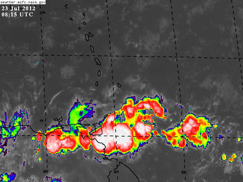
- Date: Mon, 23 Jul 2012 09:00:30 -0400
|
Good morning!
The Trinidad and Tobago Meteorological Office has issued the following information bulletin:
MODERATE TO HEAVY SHOWERS OVER TRINIDAD AND TOBAGO
MAY LEAD TO STREET/FLASH FLOODING.
Parts of Trinidad, particularly southern and eastern areas, have
been experiencing cloudy/overcast conditions with periods of rain and showers, some of which have been moderate to heavy.
Cloudy to
overcast conditions with periods of rain and/or showers, some of which
can be moderate to heavy at times and the isolated thundershower is
expected to continue over Trinidad and to a lesser extent Tobago, during
the next 3-6 hours.
It should be noted that gusty winds will
accompany moderate occasionally heavy rainfall and the possibility of
localized street and flash flooding may occur in the vicinity of heavy
showers and thunder showers.
Citizens are therefore advised to be vigilant and cautious as
they conduct their activities during the next 3-6 hours.
WE WISH TO UNDERSCORE THAT AT THIS TIME TRINIDAD AND TOBAGO IS NOT UNDER ANY TROPICAL STORM THREAT, WATCH OR WARNING.
Have a good day all!
Katy
--
Katy Young
Director
Store
Bay Marine Services Limited
Unit
B, Bago's
Beach Bar, Pigeon
Point Road,Crown
Point, Tobago
Mailing
Address: PO
Box 130,
Scarborough, Tobago
Website:
www.sbms.co.tt
Email: katy at sbms.co.tt
Phone:
660
8468 Cell: 740 2269 VHF:
Ch06 Facebook: Store Bay Marine Services: https://www.facebook.com/?sk=lf#!/group.php?gid=121639071203368
Directors:
John
R Stickland, Rajesh
Singh & Katy
Young
|
|
- - ! Impact ! -
|
- By Ian Martin Borde <readkrox51 at gmail.com>
- Date: Mon, 23 Jul 2012 06:51:32 -0400
|
Part VII :
God Bless
|
|
- Maybe, ..., Part VI, (I don't know as yet).
|
- By Ian Martin Borde <readkrox51 at gmail.com>
- Date: Tue, 17 Jul 2012 15:31:31 -0400
|
We (T&T) have had and are having some sort of blob inter-action over us.
The reason I'm posting the graphics appear to make it as getting worse! (3:25 p.m. now)
Last week it affected the south and hardly the north and capital. The Saturday (I believe) before that - once again down south - roofs were blown off and trees uprooted. Note: However that was an isolated or freak incident.
Will keep us posted, ....
God bless and Never Panic!
Attachment:
17th July 2012 1415pm.jpg
Description: JPEG image
|
|
- Part VI, and others are well on the way, ....
|
- By Ian Martin Borde <readkrox51 at gmail.com>
- Date: Sun, 8 Jul 2012 03:28:57 -0400
|
2012 - 07 - 08 Sun.
03 : 05 a.m. ( - 4.00 GMT)
Petit Valley, Diego Martin,
T'dad & T'bgo, W. I.
Good Night, Good Morning, Good Day, Good Everything,
People of Paradise,
Part VI, Out-ah-Timing:
The dry air, the south-westerly trades or jet-stream, and the encroaching 'El Nino' affect, have made our paradise an even better place to live, ..., that is during the June month.
Beginning anytime from now, (quite out of timing and surprising), a vigorous blob, (or set of blobs), is speeding towards the eastern islands of the Caribbean. They have maintained their vigorous nature in spite of dust, speed and ITCZ conditions, (mentioned before). As we all know from our predecessors and real-time island correspondents, this is not a 'good-thing'. If only the last factor, that is sea temperatures are not hospitable on arrival, (which we stress is any time NOW), will all these blobs amount to nothing, ....
Definitely every single indicator points to 'torrential' rain in three days. IE. For The Eastern Caribbean.
So, "What do we do?" the answer, dear Watson is to keep searching for clues, .... While the various modules that make up the towel brigade, in its ripple effect of love and sharing, the good with the bad, temper the tempest, ....
Once again,"Thanks!" is not the word to give Gert and Dave for providing stormcarib. They deserve more than that!
God bless
|
|
- Passing Part V
|
- By Ian Martin Borde <readkrox51 at gmail.com>
- Date: Thu, 5 Jul 2012 05:49:20 -0400
|
Just a quick note (for the records as the effect should be minimal).
Part V is now over Puerto Rico, highly disorganized and low-in-potential.
She however has a foreboding direction. Too early to tell and the chance of never organising HIGH.
God bless
|
|
- Invest 97
|
- By Katy Young <katy at sbms.co.tt>
- Date: Sat, 30 Jun 2012 07:54:08 -0400
|
Invest 97....Due East of Tobago now so worth keeping an eye on. The NHC is predicting a 10% chance of it becoming a tropical depression in the next 48 hours.
Have a good day all
Katy
--
Katy Young
Director
Store
Bay Marine Services Limited
Unit
B, Bago's
Beach Bar, Pigeon
Point Road,Crown
Point, Tobago
Mailing
Address: PO
Box 130,
Scarborough, Tobago
Website:
www.sbms.co.tt
Email: katy at sbms.co.tt
Phone:
660
8468 Cell: 740 2269 VHF:
Ch06 Facebook: Store Bay Marine Services: https://www.facebook.com/?sk=lf#!/group.php?gid=121639071203368
Directors:
John
R Stickland, Rajesh
Singh & Katy
Young
Attachment:
at201297_model.gif
Description: GIF image
|
|
- One to keep an eye on
|
- By Katy Young <katy at sbms.co.tt>
- Date: Wed, 27 Jun 2012 08:25:22 -0400
|
One to Watch....
NOAA forecast: A tropical wave located nearly midway between the west coast of Africa and the Windward Islands continues to produce disorganised showers and a few thunderstorms. Development of this wave will be slow to occur as it moves westward at 10-15 MPH. The systems has a 10% chance of becoming a tropical cyclone during the next 48 hours.
Have a good day all
Katy
--
Katy Young
Director
Store
Bay Marine Services Limited
Unit
B, Bago's
Beach Bar, Pigeon
Point Road,Crown
Point, Tobago
Mailing
Address: PO
Box 130,
Scarborough, Tobago
Website:
www.sbms.co.tt
Email: katy at sbms.co.tt
Phone:
660
8468 Cell: 740 2269 VHF:
Ch06 Facebook: Store Bay Marine Services: https://www.facebook.com/?sk=lf#!/group.php?gid=121639071203368
Directors:
John
R Stickland, Rajesh
Singh & Katy
Young
Attachment:
two_atl.gif
Description: GIF image
|
|
- Attention: Part IV maybe 'Reverse Cyclone' !
|
- By Ian Martin Borde <readkrox51 at gmail.com>
- Date: Sun, 17 Jun 2012 21:07:49 -0400
|
2012 - 06 - 17 Sun.
21 : 00 (9:00) p.m.
D'go M'rtn,
T&T, W.I.
Attention: People of Paradise :
Part IV or something like it is forming unambiguously off Santo Domingo into a low-pressure system to reckon with, ...!!!
In order of Direction - IT IS STILL EARLY -
1) Puerto Rico
2) Virgin Islands
3) Santo Domingo
4) Haiti !
I hate the stick of slander when I'm wrong. However I say without reservation, ....
THIS IS NO FALSE ALARM, ....
God Bless, (Prepare and Pray!)
|
|
- Part IV - slow, sustained, (and Sure?)
|
- By Ian Martin Borde <readkrox51 at gmail.com>
- Date: Wed, 13 Jun 2012 17:51:54 -0400
|
2012 - 06 - 13 Wed.
17 : 07 p.m. (t&t)
D'go M'rtn
T&T, W.I.
Good Day, Good Everything, People of Paradise,
Jumping straight into it. (Albeit, limited time, for now).
If we define Part IV as the high, pressure - temperatures - and - humidity -, the Trinidad & Tobago Triangle had
(pressure-cooker-effect) before each blob that passed after. Part IV is taking his time, .... He is slowly and methodically working away at wind-shear, ie. the south-westerly trades over Venezuela and Colombia and then into the Atlantic!
Locally and Instantly, Tobago had rain from 2:15 a.m. till about nine o'clock, (whole day overcast).
Trinidad (esp. south), had rain after seven o'clock with quite a heavier variety from 9:00 a.m. - 12 30 p.m (whole day overcast)
That is until now. We don't expect change for another 8 -18 hrs. when sad to say (Part IV style) after a break for added heat and pressure the next blob arrives.
eg.
THE ITCZ BEGINS
AND CONTINUES ALONG 5N40W 6N50W TO 8N60W. CLUSTERS OF SCATTERED
MODERATE TO ISOLATED STRONG CONVECTION ARE FROM 6N-13N W OF
55W...FROM 2N-7N BETWEEN 36W-43W...AND FROM 5N-12N BETWEEN
15W-24W.
Hopefully we got it all wrong. (attachments failed).
God Bless
|
|
- ???Possible Part IV??? - in less than 24 - 36 hrs.
|
- By Ian Martin Borde <readkrox51 at gmail.com>
- Date: Tue, 5 Jun 2012 01:06:24 -0400
|
2012 - 06 - 05 Tues.
12 : 10 a.m.
Diego Martin
T&T, W.I.
Good Night, Good Day, Good Everything, People of Paradise,
Weird (computer) Graphics - Typical (Climate-Change) Weather
It is very, very difficult to rationalize and explain why factors are better for a slightly stronger Impact with this Tropical Wave but in cases of peril and hazard to life and limb it is best to give 24 hours warning where it is possible to do so, ....
The internet meteorology looks like a white, multicolored spotted animal streaking in a zigzag fashion, not knowing where to go at high speeds. The daily weather forecast for the two most southerly islands will go like, ...;
Overcast and high-level cloudiness with two short periods of medium to heavy rainfall for less than ten minutes that can produce street, standing and running water. The rest of the sunlight hours, every twenty minutes expect the winds to range from still to over 25 mph. Temperatures and humidity and pressure 'exceptionally' pleasant except before rainfall. Seas always high or choppy with periods of 'calm' before the storms.
This is 'daily' since a little over a year.
One other point (that helps it develop circulation at some stage) the 'blob' is starting to separate from 10 N latitude and move 'north'.
God bless
Ps The 'scissors-tail' bird (probably the north-american 'swallow') the biggest bird in the tropics that leaves the south-american summer and migrates back to the north-american summer was spotted two weeks ago. It normally migrates late February early March.
Attachment:
4th June 1115 pm.jpg
Description: JPEG image
Attachment:
04th June 1134pm.jpg
Description: JPEG image
Attachment:
4th June 1145 pm.jpg
Description: JPEG image
|
|
- Part I, II and III, ...
|
- By Ian Martin Borde <readkrox51 at gmail.com>
- Date: Thu, 24 May 2012 17:21:41 -0400
|
2012 - 05 - 24 Thurs.
05 : 10 p.m.
D'go M'rtn,
T.&T., W.I.
Pleasant Greetings, People of Paradise,
Just for the sake of adding it to the records before we have Part IV.
Part I = 'Alberto'
Part II = In the Florida Keys right about now. (with a 40% chance, which I agree with.) (based on reports from Cuba.)
Part III= Over St. Vincent, (for a while now), and affecting 'us' at this moment in time.
My point is:
According to my daughter, "What storm?" "Wouldn't have noticed. It's been like this since last year, ...."
For my part, there's lots of preparation and work to be done. So any weather that is not downright 'hazardous' is a welcome tropical 'breeze'.
God bless
|
|
- Just around de corner, ... !?
|
- By Ian Martin Borde <readkrox51 at gmail.com>
- Date: Wed, 9 May 2012 05:16:20 -0400
|
2012 - 05 - 09th Wed.
04 : 55 a.m.
Diego Martin,
T.&T., W.I.
Pleasant Pleasantries to The People of Paradise,
What have you with ) eclipses ) super-moons ) space vehicles on 747's ) elections ) double dips and opposition whips ) etc. The media are having a ball, ....
We, who have gigantic problems like frogs crackling in the night, mosquitoes playing notes in your ear, birds eating the dog food, children who go to school because the next holiday is either Friday or Monday, ..., we don't really get phased by volcanoes, tsunamis and hurricanes. It's all everyday life.
Just around the corner is not June 1st and the beginning of the hurricane season.
Just around the corner are two blobs (low pressure precipitation), south-west and east of Trinidad and Tobago. This should drive the point home that 1) The north-east trades may be no longer 2) The south-west jet-stream from now on is our saviour 3) Things have changed and the effects are up-to-us, ....
Remember always, if you can't avoid, handle or fix the danger minimize your movement, ....
God Bless
Attachment:
09th May 345 am.jpg
Description: JPEG image
|
|


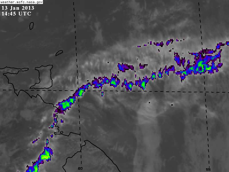
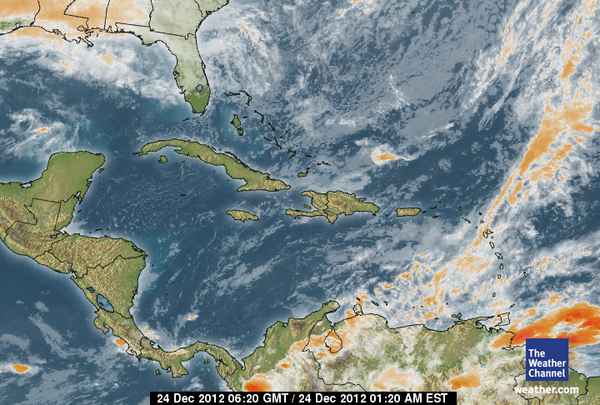
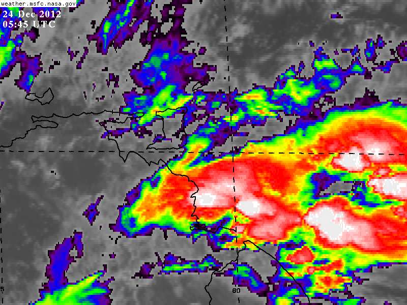
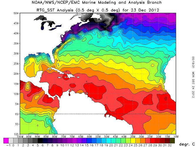
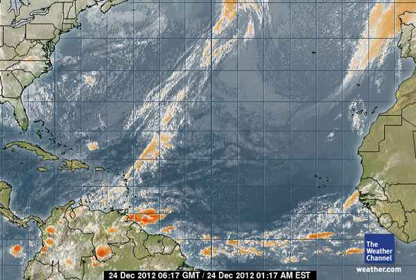
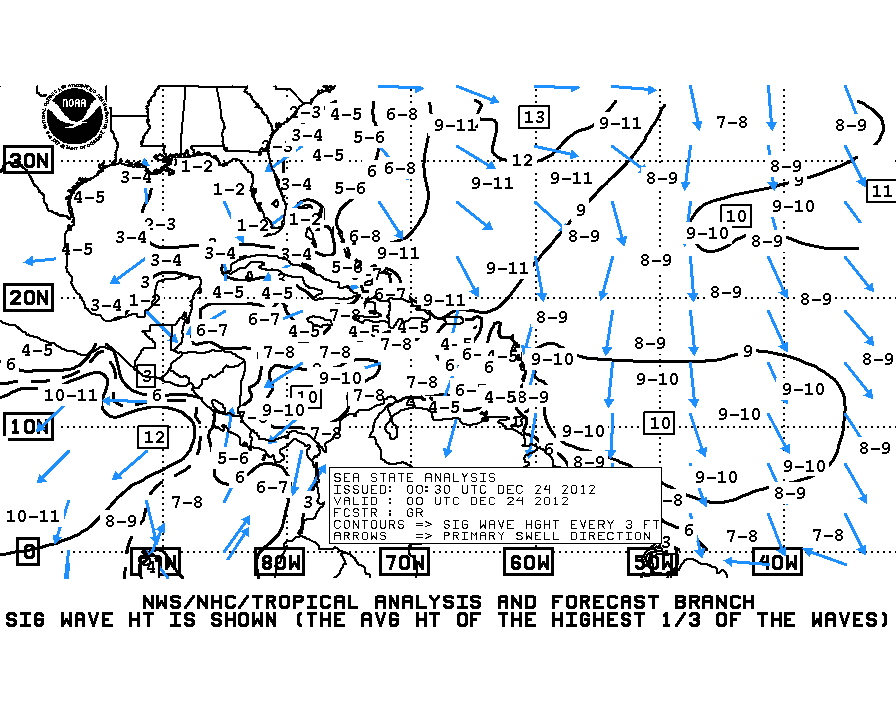
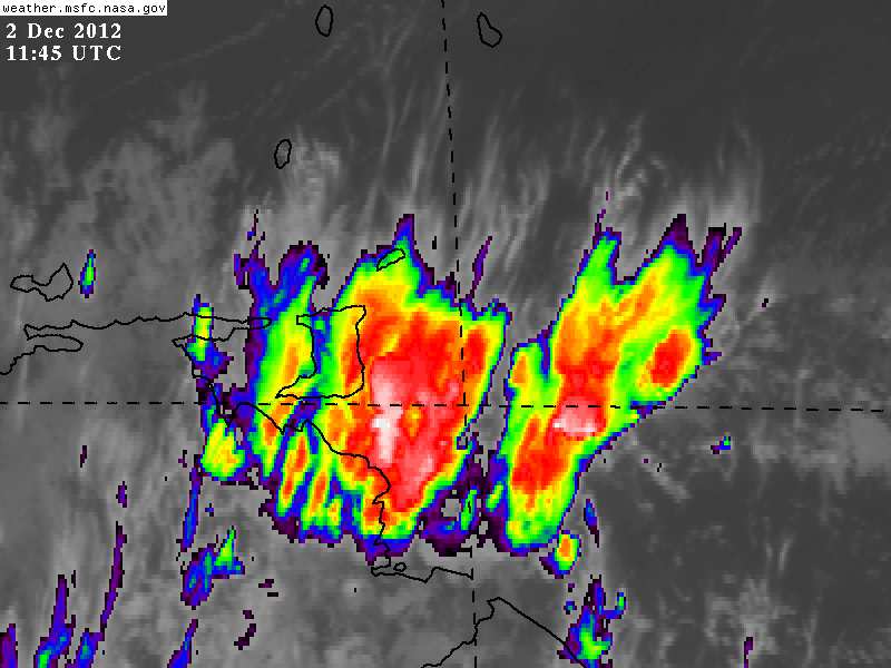
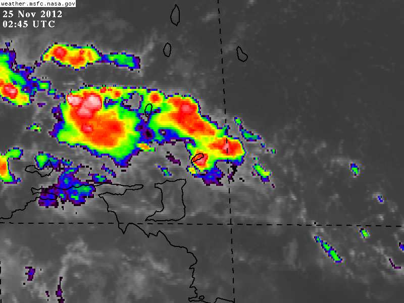
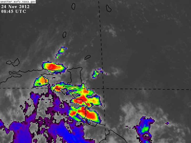
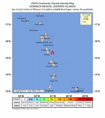
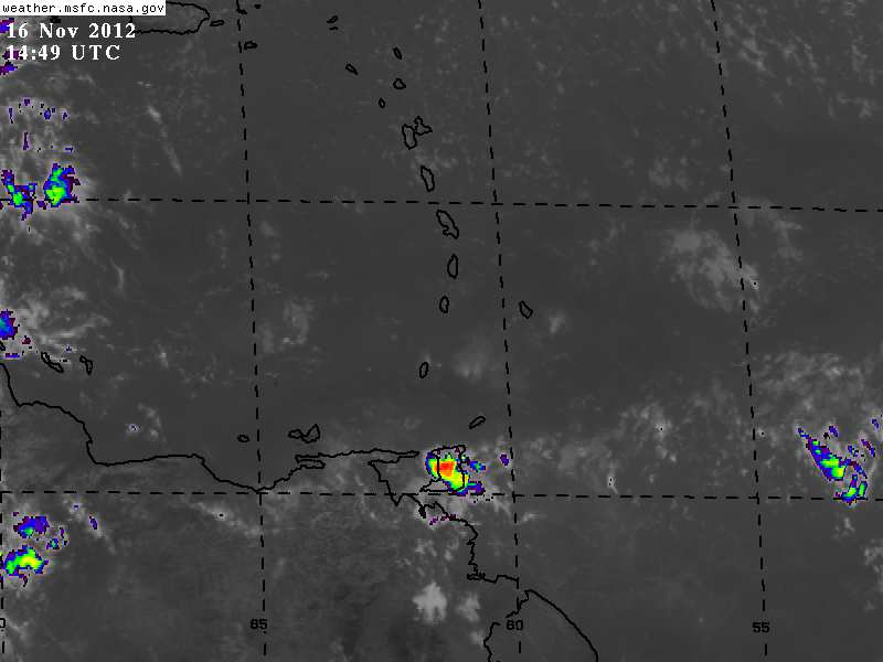
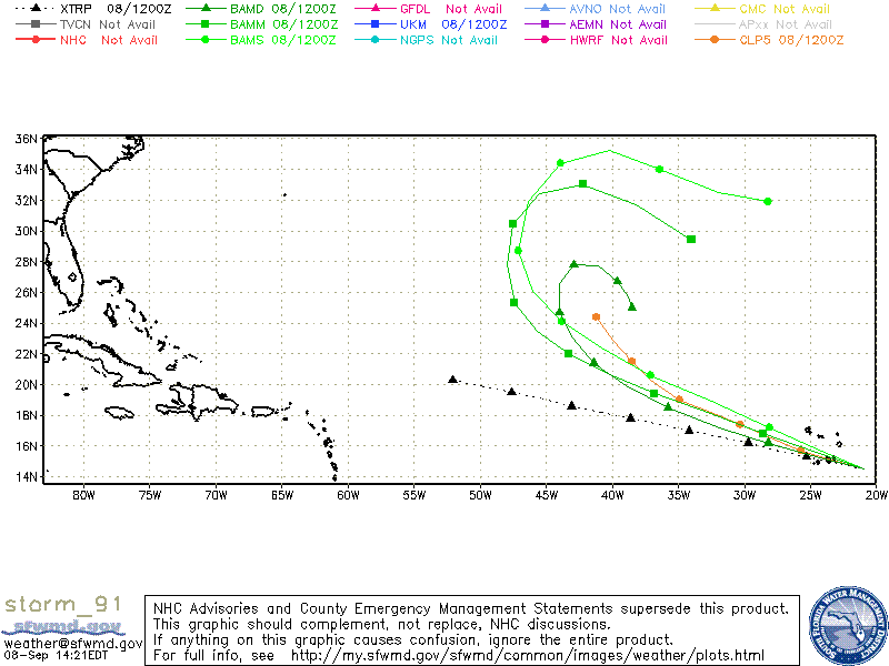
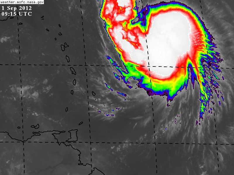
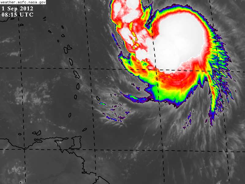
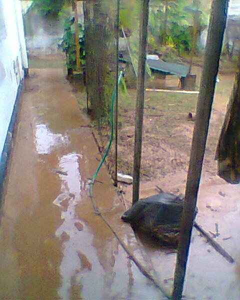
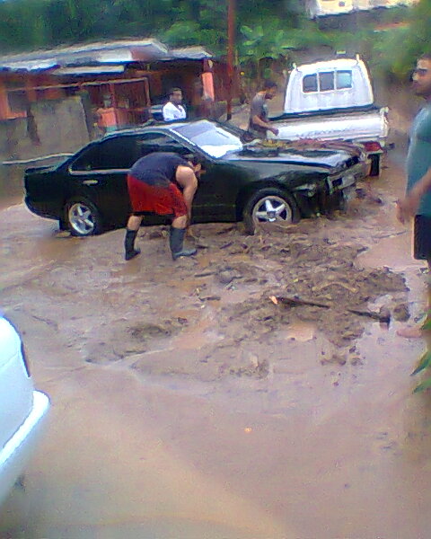
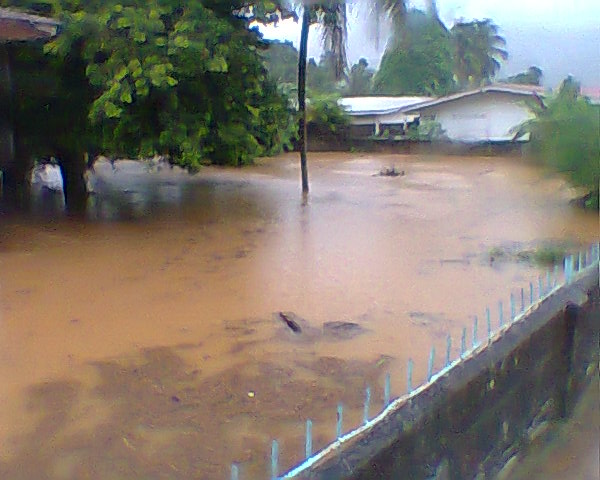
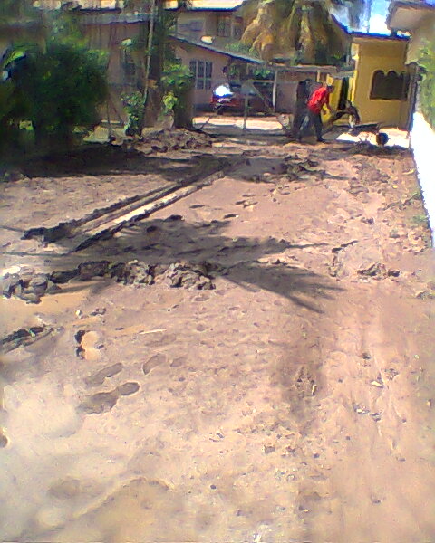
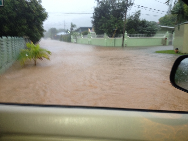
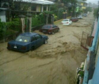
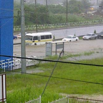
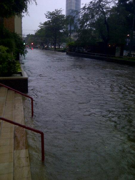
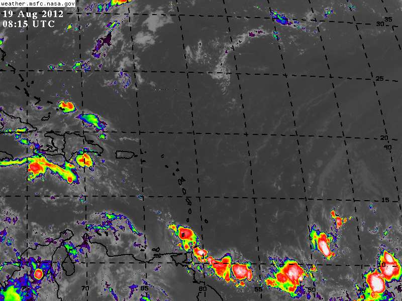
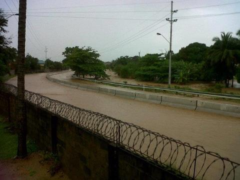
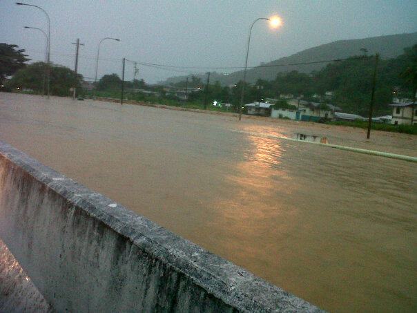
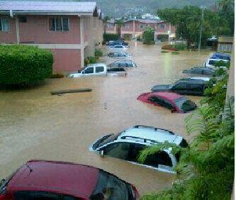
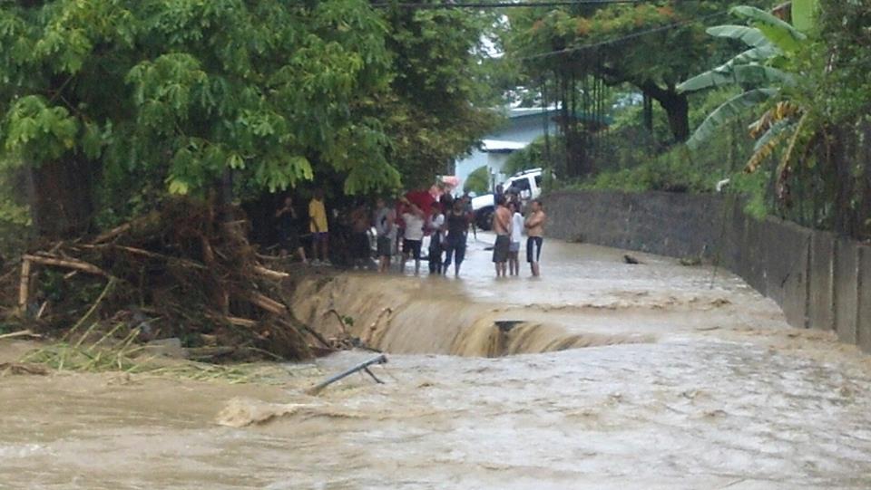
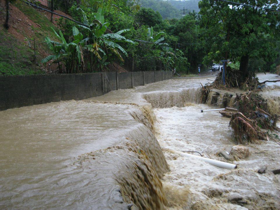
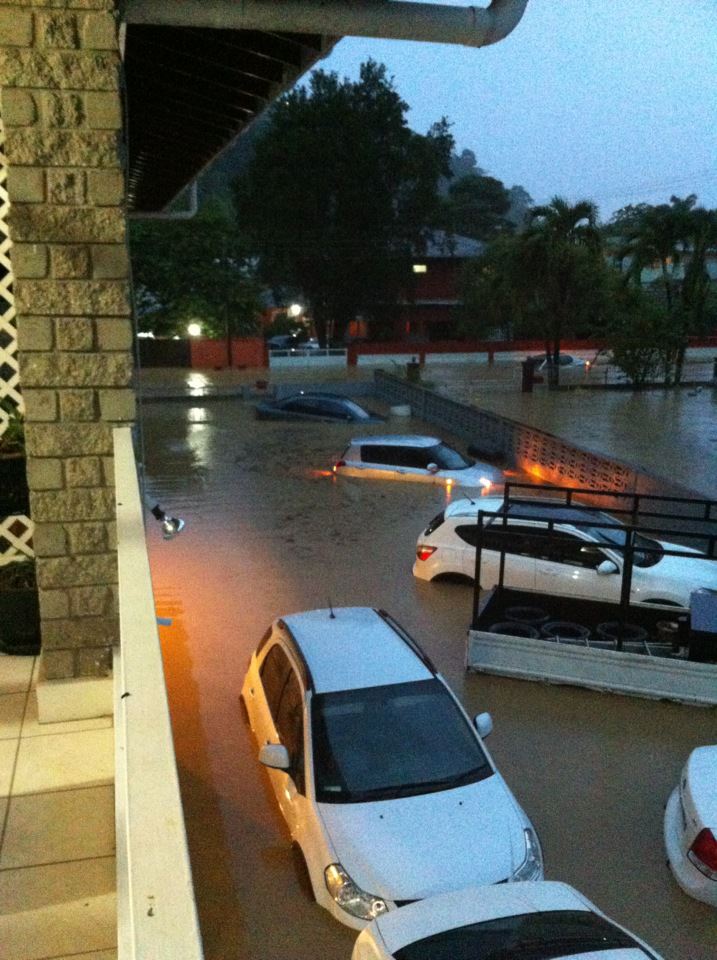
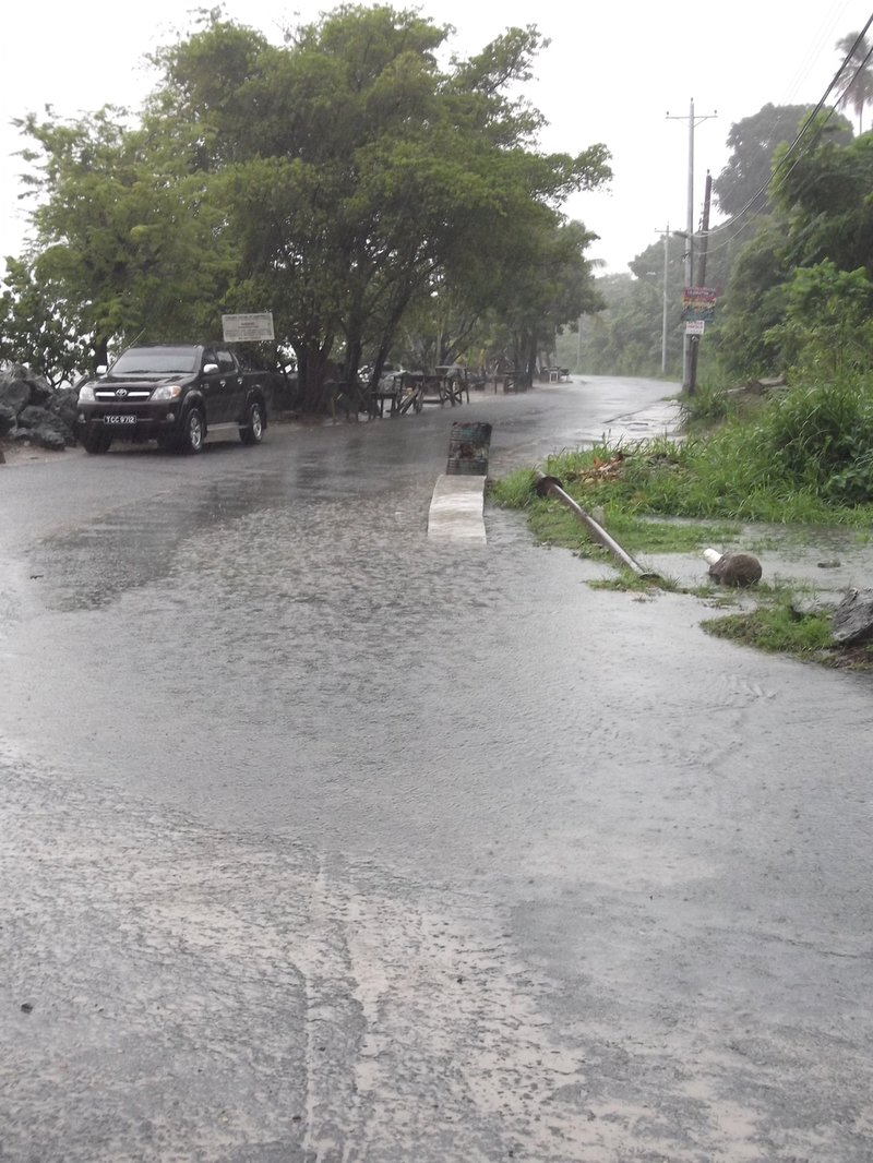
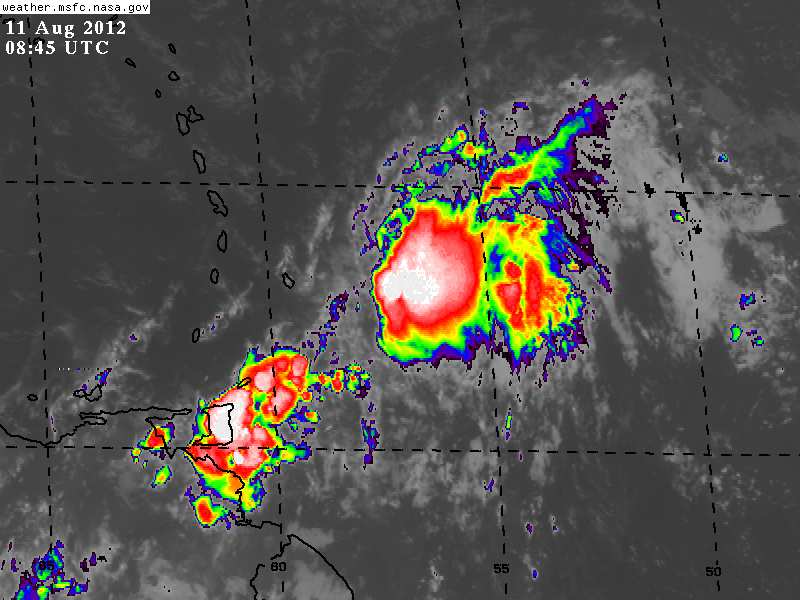
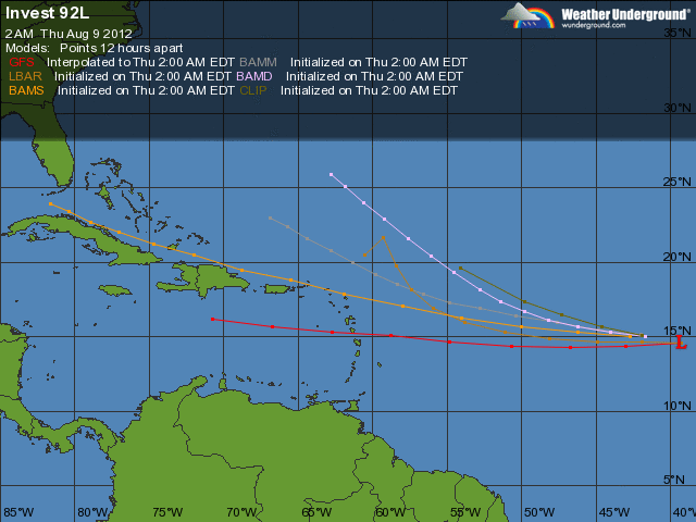
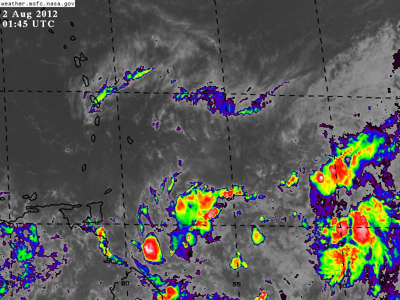
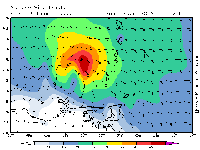
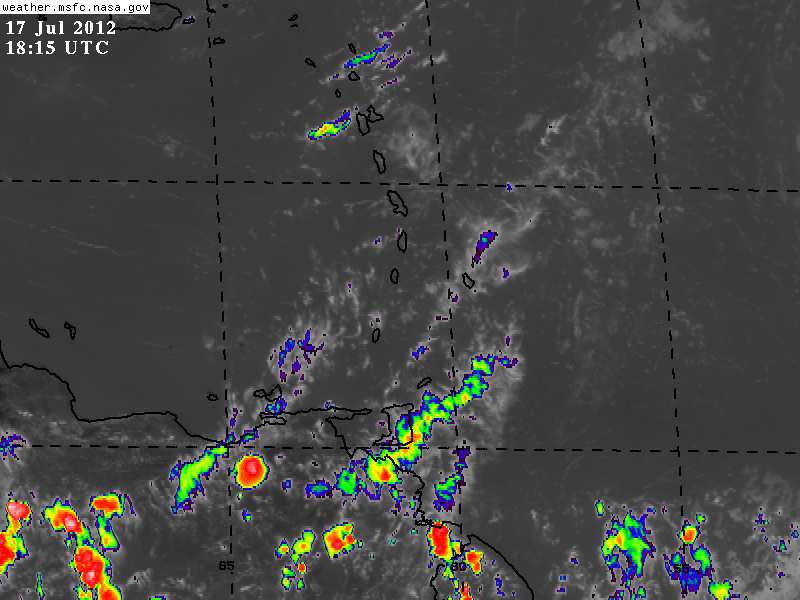
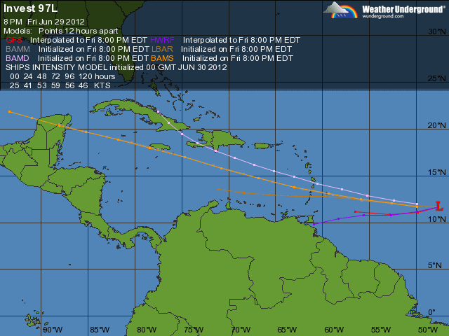
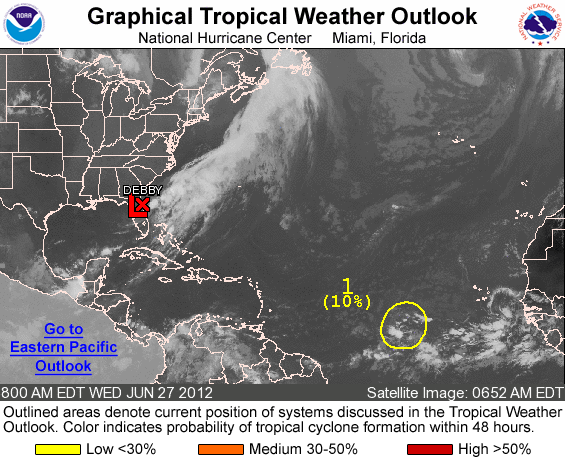
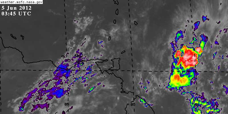
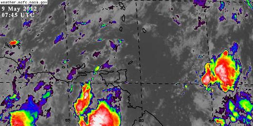