|
- - - 2011 Hurricane Season - - -
|
- Me see, ..., me thinks, ..., ....
|
- By Ian Martin Borde <readkrox51 at gmail.com>
- Date: Sun, 29 Apr 2012 13:23:49 -0400
|
2012 - 04 - 29th. Sun.
13 : 20 ( p.m. )
T. & T., W.I.
Welcome People of Paradise,
To the Land of The former Cricket Champions, ..., Sun, Sand and Surfing. And don't forget Parties, ....
By the way, excuse me as we are usually a little off target, but am I seeing some activity 'early' in the season ???!!!
There are more questions than answers.
When's the next party?
God Bless
|
|
- Northerly swell
|
- By Katy Young <katy at sbms.co.tt>
- Date: Fri, 30 Mar 2012 08:27:04 -0400
|
According to Passage Weather a northerly swell will hit the north end of Tobago at Charlotteville. Although not big (1-2m) it will be coming right into Charlotteville. Store Bay in the south will be protected by the northerly swell by Buccoo Reef. The swell will last until early Sunday morning and then will return next Friday according to forecast models. See pictures for further information.
Have a good day all
Katy
--
Katy Young
Director
Store
Bay Marine Services Limited
Unit
B, Bago's
Beach Bar, Pigeon
Point Road,Crown
Point, Tobago
Mailing
Address: PO
Box 130,
Scarborough, Tobago
Website:
www.sbms.co.tt
Email: katy at sbms.co.tt
Phone:
660
8468 Cell: 740 2269 VHF:
Ch06 Facebook: Store Bay Marine Services: https://www.facebook.com/?sk=lf#!/group.php?gid=121639071203368
Directors:
John
R Stickland, Rajesh
Singh & Katy
Young
Attachment:
015.png
Description: PNG image
Attachment:
168.png
Description: PNG image
|
|
- De dryest month ah de year, ...!
|
- By Ian Martin Borde <readkrox51 at gmail.com>
- Date: Sun, 11 Mar 2012 12:13:47 -0400
|
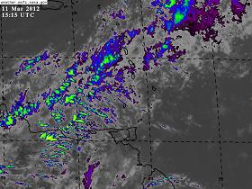
This pic sums up now the driest month in the year
for T'dad & T'bgo has been, ie. March.
|
|
- Rainy Thursday
|
- By Katy Young <katy at sbms.co.tt>
- Date: Fri, 24 Feb 2012 15:35:38 +0000
|
Morning all -
Just a heads up for Thursday - Windguru is predicting lots of rain - up to 36mm on Thursday morning in Tobago, winds gusting 21knots in an Easterly direction, wave height 2.9 metres, wave direction ENE. Its still early days and might all change but worth keeping an eye on. Interesting Grenada is also getting rain on Thursday.
Thanks
Katy
--
Katy Young
Director
Store
Bay Marine Services Limited
Unit
B, Bago's
Beach Bar, Pigeon
Point Road,Crown
Point, Tobago
Mailing
Address: PO
Box 130,
Scarborough, Tobago
Website:
www.sbms.co.tt
Email: katy at sbms.co.tt
Phone:
660
8468 Cell: 740 2269 VHF:
Ch06 Facebook: Store Bay Marine Services: https://www.facebook.com/?sk=lf#!/group.php?gid=121639071203368
Directors:
John
R Stickland, Rajesh
Singh & Katy
Young
|
|
- 'More than Usual' - The New Norm -
|
- By Ian Martin Borde <readkrox51 at gmail.com>
- Date: Wed, 25 Jan 2012 03:53:37 -0400
|
2012 - 01 - 25 Wed.
03 : 20 a.m.
T&T, W.I.
Good Day, Good Everything, People of Paradise,
The Action is at Night !
Were it possible to windsurf in the night, one will have a great time with a 'S' sail. (And a wet-suit).
The temperature at 2:00 a.m. (one hour ago), was 75 F. or 24 C.
Winds (not breezes), in the night for the whole night, are (I would guestimate) at 25 - 32 mph. every 10 - 20 minutes. Gusts not lasting a complete minute.
Light rain falls three times a night for less than 8 minutes. However accompanied by fresh winds and air current noises and pattering roofs.
Thirty - six hours ago we had rain for a little over two days straight.
This is NOT normal.
The day times could easily lead one to report sick for 'work' and go to the beach. Except the waves and currents prevent even hardened fishermen from cursory excursions. The sun shines, the mood is festive (and a little congested), the food is great, the drinks are plentiful, the 'wild-life' is displaying its fine form, and what have you in this tropical paradise called The West Indies.
Being on a Wellness Program for some time now, what helps me lose weight in my diet and exercise and sleep program, is 'fruit salad'. You get mangoes, or pomme-se-terre, or portugals, or guavas, mix it with cucumber and add garlic, pepper and salt, (fresh herbs, if available like chive, thyme, shadu-bene (selantro), ) The acid counter-reacts with the acid that makes you hungry, apparently, while boosting energy and a feeling of wellness. Just remember too much of a good thing is good for nothing. So exercise moderation.
At this point, it may be safe to say "Expect anything." weather-wise. My! Times have changed.
God Bless
|
|
- Organized Confusion - CARNIVAL - Masquerade and Bacchanal -
|
- By Ian Martin Borde <readkrox51 at gmail.com>
- Date: Tue, 10 Jan 2012 04:20:39 -0400
|
2012 - 01 - 10 Tues.
03 : 50 a.m.
T & T, W.I.
Masquerade, Music and Mayhem (Controlled) -
- The CARNIVAL Celebrations have BEGUN -
This week-end gone, The Steel-Drum Orchestras played their hearts and soul out in their respective regional competitions to get a place 'in the big-yard'. IE. the Queen's Park Savannah, Port of Spain. While competition is stiff. Their 'tribes' showed what forces lay in each district, simply by having fun (party) in the sun.
Then, ( besides old mas', old-time mas, pretty mas (kings and queens), limbo, chutney, kaiso, soca, groovy soca, and ex-tempo, among others,....) THERE ARE PARTIES,..., AND MORE PARTIES , ..., TILL THE BREAK OF DAWN. That is until the next party.
??? Who cares about The Weather ???
I'll keep you posted, - on the weather - (yeah, right) : )
God Bless
Attachment:
Band 2011.jpg
Description: JPEG image
Attachment:
King.jpg
Description: JPEG image
Attachment:
Queen.jpg
Description: JPEG image
|
|
- CORRECTION
|
- By Ian Martin Borde <readkrox51 at gmail.com>
- Date: Sun, 8 Jan 2012 00:21:43 -0400
|
2012 - 01 - 08 Sun.
12 : 10 a.m.
T & T, W.I.
A correction has to be made to a 'post' on a different web-page, in a different quarter.
- TOMORROW ( IE. SUNDAY ) WILL HAVE THE SAME OR MORE RAIN -
We (T&T) have been having rain somewhere between 7:00 - 9:00 a.m., lunch-time, then sometimes in the dusk/evening period. (ie. Light rain).
This will continue tomorrow. (And is highly corroborated.)
Eg.
TO THE S...A SURFACE TROUGH IS N OF SOUTH AMERICA AND SE OF THE
WINDWARD ISLANDS ALONG 12N54W TO 7N58W. THE TROUGH IS EMBEDDED
WITHIN AN AREA OF DEEP LAYER MOISTURE WHICH IS HELPING SUPPORT
SCATTERED SHOWERS FROM 8N-13N BETWEEN 43W-61W.

While this may be 'refreshing'. One can never be too careful.

God Bless
|
|
- New Year, New Moon, New Season
|
- By Ian Martin Borde <readkrox51 at gmail.com>
- Date: Tue, 3 Jan 2012 06:52:31 -0400
|
2012 - 01 - 03 Tue.
06 : 30 a.m.
T & T, W.I.
HAPPY NEW YEAR - PEOPLE of PARADISE
The new moon was really around the 26th December, when the dry season (I'll tell you what we mean by that) began for Trinidad and Tobago. Moreso, it spelled the end of floods, blown roofs, coastal erosion, and long spells of rainy weather.
What the Full Moon on the 9th January (Monday coming) will mean as the first full moon in dry season is anybody's guess.
But,
This is going to be a Very Good 2012 and Bright New Year !
Because the last two years the ultimate in seasonal 'bad' weather was short of being 'a breeze'. Thank God!
The Northern Islands specially should take note of the latest discussion. {It is my firm belief we should get away from 'labels' (eg. storm)} and focus HEAVILY on 'cause and effect' of pressure, humidity, wind, moisture, temperature on persons and property. Here goes,
DISCUSSION
GULF OF MEXICO...
THE FRONT PREVIOUSLY ACROSS THE GULF OF MEXICO HAS NOW MOVED OUT
OF THE AREA INTO THE W ATLC AND NW CARIBBEAN.
CARIBBEAN SEA...
A SHEAR AXIS IS AHEAD OF THE FRONT ALONG
20N79W TO 17N84W DEPICTING STRONGER NE WINDS OF 20 KT
CONVERGING INTO WEAKER 10-15 KT WINDS. SCATTERED SHOWERS ARE
WITHIN 60 NM NW OF THE AXIS.
15-20 KT ELY TRADEWIND FLOW COVERS THE
CENTRAL AND ERN CARIBBEAN WITH EMBEDDED ISOLATED SHOWERS S OF
HISPANIOLA AND ACROSS THE WINDWARD ISLANDS. SOME STRONGER WINDS
UP TO 25 KTS ARE NOTED NEAR THE COAST OF COLOMBIA. EXPECT THE
FRONT TO CONTINUE TO PUSH SE OVER THE NEXT 24 HOURS WITH STRONG
N-NE WINDS BEHIND IT AND SHOWERS/POSSIBLE THUNDERSTORMS ALONG
IT.
ATLANTIC OCEAN...
A COLD FRONT ENTERS THE DISCUSSION AREA NEAR 32N70W CONTINUING
ACROSS THE NRN BAHAMAS NEAR 25N77W TO WRN CUBA AT 23N80W...AS OF
0300 UTC. A LINE OF SHOWERS/POSSIBLE THUNDERSTORMS IS ALONG THE
AXIS WITH STRONG NWLY WINDS BEHIND IT CURRENTLY UP TO 25-30
KT...BUT WILL BE REACHING 35 KT OR GALE FORCE N OF 27N BY 0600
UTC. A PRE-FRONTAL SURFACE TROUGH IS AHEAD OF THE FRONT ALONG
32N66W 27N71W 23N73W. SCATTERED SHOWERS/ISOLATED THUNDERSTORMS
ARE WITHIN 150 NM E OF THE AXIS. THIS SYSTEM IS SUPPORTED BY AN
UPPER LEVEL TROUGH COVERING THE ERN CONUS AND FAR WRN ATLC.
EXPECT
THE FRONT IN THE W ATLC TO CONTINUE TO PUSH EWD OVER THE NEXT
SEVERAL DAYS.
Have a splendiferous New Year !!!
|
|
- Swells coming in tomorrow
|
- By Katy Young <katy at sbms.co.tt>
- Date: Thu, 29 Dec 2011 15:24:39 -0500
|
Looks like we've got some swells coming into Tobago on Friday (tomorrow). Windguru is predicting the waves will pick up by midmorning tomorrow with a wave height of around 3.4metres but will be calming down into Saturday and Sunday. Wind gusts of up to 27knots. Wind direction moving from E-ENE.
Have a good day all
Katy
--
Katy Young
Director
Store
Bay Marine Services Limited
Unit
B, Bago's
Beach Bar, Pigeon
Point Road,Crown
Point, Tobago
Mailing
Address: PO
Box 130,
Scarborough, Tobago
Website:
www.sbms.co.tt
Email: katy at sbms.co.tt
Phone:
660
8468 Cell: 740 2269 VHF:
Ch06 Facebook: Store Bay Marine Services: https://www.facebook.com/?sk=lf#!/group.php?gid=121639071203368
Directors:
John
R Stickland, Rajesh
Singh & Katy
Young
|
|
- 3rd Day of White-Out
|
- By Ian Martin Borde <readkrox51 at gmail.com>
- Date: Thu, 22 Dec 2011 08:00:39 -0400
|
2011 - 12 - 22nd Thu.
07 : 15 a.m.
T & T, W.I.
There may be Damage-Control !
Instead of bringing you the Christmas Joy of this time of year.
Eg. Garlic Pork, Fruit/Rum cake, Ginger bread biscuits, Pastelles, Paymee, Picnic Ham, Roast Pork, Turkey Ham, Black Pudding, Bread Pudding, Banana Cake, Carrot Cake, Pineapple Upside-Down Cake, Cheese Cake, Pelau, Black-Eye Peas and Rice, Turkey, Salted pig-tail and peas (pigeon), etc. all cooked with exotic local herbs. (Guinness Ice-Cream for Dessert).
Or, writing about the libations of: Rum and Coke, Scotch and coconut water, Fine wines, Cognacs, Sherry & Brandies, Rum-Punch, Punch-a-Creme, chased with 'What has to be the Home of Chasers, i.e. The West Indies'.
Of course, 'The Reason for The Season'; The Creche, Midnight Mass, Caroling or 'Parang', Vigil, Charity Events, etc. 
We are writing that we have a 3rd. day of partial to total 'White-Out' (24 hrs. island-wide). It's a mostly soft drizzle but definitely interspersed with 5-8 mins. showers. Today sometime there will be damage control. Not to mention a damper on painting and season cleaning and repairs.
In the spirit of the overcast, we wonder what 2012 has in store at the rate we are going 'industrialization and specialization' to acheive financial independence and eliminate 'cottage and small-scale industry' with efficiency and surplus (as tourist attractions).
God Bless
|
|
- As Announced, ....
|
- By Ian Martin Borde <readkrox51 at gmail.com>
- Date: Tue, 20 Dec 2011 00:14:32 -0400
|
We totally agree with this, ....

EXPECT A FRONTAL
BOUNDARY N OF THE BASIN IN THE W ATLC TO BEGIN BRINGING SHOWERS
TO HISPANIOLA AND THE NRN LEEWARD ISLANDS WITHIN THE NEXT 12-24
HOURS. A SURFACE TROUGH AND ASSOCIATED CONVECTION IS ALSO E OF
THE WINDWARD ISLANDS AND IS EXPECTED TO ADVECT WWD WHICH WILL
IMPACT THE SRN WINDWARD ISLANDS.

Also we need to have a noteworthy look at the earthquake off Mexico
and Guatemala, ....

http://earthquake.usgs.gov/earthquakes/eqarchives/last_event/world/world_mexico.php

Stay Safe and Soundly Secure.

God Bless
|
|
- Swells in Tobago and Trinidad
|
- By Katy Young <katy at sbms.co.tt>
- Date: Sun, 18 Dec 2011 12:34:55 +0000
|
Morning All,
Just to update you that it is pretty swelly in Store Bay and Chaguaramas this morning. Wind Guru is predicting wave height of up to 2m today in Store Bay and it looks set to increase throughout the week to a maximum of 3m on Thursday night/early Friday morning. The wave direction will also change throughout the week from NE-NNE-ENE. Winds are also picking up throughout the week - up to gusts of 26 knots Tuesday-Thursday although it is forecast to start coming down from Friday. There is also going to be some rain on Tuesday/Wednesday (great for filling your water tanks).
For Chaguaramas the wave height will also increase throughout the week to a maximum of 2.9m early Friday morning. The wave direction is also moving from NE-NNE-ENE. Chaguaramas is predicted to get less wind than Store Bay - gusts of 26knots occassionally.
Stay safe all
Best wishes
Katy
--
Katy Young
Director
Store
Bay Marine Services Limited
Unit
B, Bago's
Beach Bar, Pigeon
Point Road,Crown
Point, Tobago
Mailing
Address: PO
Box 130,
Scarborough, Tobago
Website:
www.sbms.co.tt
Email: katy at sbms.co.tt
Phone:
660
8468 Cell: 740 2269 VHF:
Ch06 Facebook: Store Bay Marine Services: https://www.facebook.com/?sk=lf#!/group.php?gid=121639071203368
Directors:
John
R Stickland, Rajesh
Singh & Katy
Young
|
|
- Suspecting some southerly showers, ....
|
- By Ian Martin Borde <readkrox51 at gmail.com>
- Date: Wed, 14 Dec 2011 16:23:12 -0400
|
2011 - 12 - 14th Wed.
16 : 10 p.m.
T & T, W.I.

Good afternoon, good day, good everything, People of Paradise,

Really, it's more than suspecting.
All indications, (non-cyclonic), are that for the next two and a half
(2 1/2) days, there will be;
-Moisture in the atmosphere
-Low pressures
-(Relatively) Warm waters
That is the more southerly you are the more this pertains to you.
Unless the system in the North Central Atlantic develops 'feed' for
itself, ....

Nothing to worry about. Just a little more than the 'snowy' drizzle we
get everyday at midday.

On the side, you will never guess?
"My daughter finally came face to face with the father iguana".
Guess among all this moisture he saw the 'bright' side.

God Bless
|
|
- Mysterious Reprieve
|
- By Ian Martin Borde <readkrox51 at gmail.com>
- Date: Thu, 8 Dec 2011 20:41:27 -0400
|
2011-12-08
20:20p.m.

Good Night, Good Morning, People of Paradise,

There are a few 'signs' and even less evidence, that some sort of
'Impact' will affect (most of The Lesser Antilles) us tonight. This
will last one day and a half (no more). (Sunshine, fresh breezes and
comfortable humidity after.)

If we are correct it has started already over Caracas/Margarita,
Venezuela. And the border of Guyana and Venezuela (off
Manzanilla/Mayaro, T&T).

The signs are; no wind, Lower than median range pressures for this
time of year, hot humidity (even at night), etc. eg. Mossies and
frogs, and birds.

Please don't over-react on this one, specially as this seems to be the
last of 'the pressure cooker' effect. But circular motion has and
could develop any where during 'hazardous' weather as we have seen.
Small or large in circumference. Short of Long.

Use this year's story of storms to be better equipped next time.

God Blesses Develops and Grows, what only we can furrow plant and sow.

Happy Holiday Season
|
|
- Tail end of hurricane season brings rain to Tobago
|
- By Katy Young <katy at sbms.co.tt>
- Date: Wed, 7 Dec 2011 12:29:49 +0000
|
Morning All,
Looks like its going to be a wet day in Tobago today. Already had enough rain since early this morning to cause some localised flooding on roads (see attached photos). There are also reports of some small landslides in the north of the island.
The rain should ease by late afternoon but looks like we're going to get some more during the rest of the week. Wind direction for today ENE, 15 Knts with gusts up to 17 Knts. Maximum wave height 1.6 metres, direction NE. Humidity high of 78%. Maximum temperature 28 degrees.
Have a good day all
Katy
--
Katy Young
Director
Store
Bay Marine Services Limited
Unit
B, Bago's
Beach Bar, Pigeon
Point Road,Crown
Point, Tobago
Mailing
Address: PO
Box 130,
Scarborough, Tobago
Website:
www.sbms.co.tt
Email: katy at sbms.co.tt
Phone:
660
8468 Cell: 740 2269 VHF:
Ch06 Facebook: Store Bay Marine Services: https://www.facebook.com/?sk=lf#!/group.php?gid=121639071203368
Directors:
John
R Stickland, Rajesh
Singh & Katy
Young
Attachment:
Crown Point, Tobago.jpg
Description: JPEG image
Attachment:
Flooding on Pigeon Point Road.jpg
Description: JPEG image
Attachment:
Pigeon Point Road, Tobago.jpg
Description: JPEG image
|
|
- End of another season
|
- By Katy Young <katy at sbms.co.tt>
- Date: Sat, 3 Dec 2011 13:00:17 +0000
|
It's been pretty quiet weather wise for Tobago this season. Again Store Bay Marine Services will continue to post any significant weather updates.
Best wishes
Katy
--
Katy Young
Director
Store
Bay Marine Services Limited
Unit
B, Bago's
Beach Bar, Pigeon
Point Road,Crown
Point, Tobago
Mailing
Address: PO
Box 130,
Scarborough, Tobago
Website:
www.sbms.co.tt
Email: katy at sbms.co.tt
Phone:
660
8468 Cell: 740 2269 VHF:
Ch06 Facebook: Store Bay Marine Services: https://www.facebook.com/?sk=lf#!/group.php?gid=121639071203368
Directors:
John
R Stickland, Rajesh
Singh & Katy
Young
|
|
- Preface of (Isolated and Singular) Torrential Conditions
|
- By Ian Martin Borde <readkrox51 at gmail.com>
- Date: Sat, 3 Dec 2011 04:19:56 -0400
|
Apparently there was torrential rainfall (and wind) twice yesterday,
ie. afternoon after mid-day and late-evening (night-time).

Reports on Facebook and Printed Media said roofs were blown off in
Carenage (Sea-View Gdns.)

I am extremely busy and exhausted but when the information comes in
and I get time to research the maps will post again if others don't,
....

God Bless
|
|
- Part XXXV is coming (BUT, further North)
|
- By Ian Martin Borde <readkrox51 at gmail.com>
- Date: Sat, 26 Nov 2011 14:47:31 -0400
|
2011 - 11 - 26th. Sat.
14 : 35 p.m.
T&T, W.I.

(Talking about blobs, from The East ie. normal African TW's), Part
XXXV is approaching Barbados. (Roughly 2 hrs. away.) The actual axis
is (more than) 24 hrs. away.

Of concern is the - environment - it will meet. This seems conducive
(at this point/time) for HEAVY rainfall.

That is - Winds - Moisture/Humidity - Pressure/Temperature ?

It's better NOT to be caught, of guard.

God Bless
|
|
- T & T expect 2 days of sunshine
|
- By Ian Martin Borde <readkrox51 at gmail.com>
- Date: Fri, 25 Nov 2011 04:55:42 -0400
|
2011 - 11 - 25 Fri.
04 : 10 a.m.
T&T, W.I.
Good Night, Good Morning, Good Day, Good Everything, People of Paradise,
And it really should be a few bright and good days ahead of us, with long moments of sunshine.
As Dave (and Gert) wrote this may not be a good thing later on. Because the reason the moisture is drying up over T & T, is to our East and West moisture is developing and absorbing into some 21st Century pattern. (tee hee)
God Bless
|
|
- More Mudslides
|
- By Michelle Rudder <themiche at tstt.net.tt>
- Date: Mon, 21 Nov 2011 22:26:26 -0400
|
|
.... and this time, I got hit. The whole Maraval valley in west POS is a mess, and more rain is forecast. See my new backyard.
Attachment:
Backyard.jpg
Description: JPEG image
Attachment:
Backyard 2.jpg
Description: JPEG image
Attachment:
My driveway.jpg
Description: JPEG image
|
|
- More flooding!
|
- By Christine Westmaas <chrisalis1003 at yahoo.co.uk>
- Date: Tue, 22 Nov 2011 02:08:44 +0000 (GMT)
|
After Saturday's massive flooding in some areas in north Trinidad, the heavens opened again today and there has been more damage and more flooded streets and homes in and around Port-of-Spain. In San Fernando, south Trinidad, we had lowering skies and periodic heavy rainfall but all is quiet and calm tonight. The forecast is for more rain tomorrow, not a happy prospect for those in flood-prone areas or for those affected by the rain-influenced traffic jams and consequent shortage of public transport. |
|
- Back on Track
|
- By Ian Martin Borde <readkrox51 at gmail.com>
- Date: Mon, 21 Nov 2011 20:48:21 -0400
|
Good Night, Good Morning, Good Day, Good Everything, People of Paradise,
Taking some reprieve from heavy stuff to NOT be an Alarmist for TRINIDAD & TOBAGO, ..., BUT as NHC seems to corroborate, ..., after three - to - four days of HEAVY RAIN with Localized Flooding, there seems to be a Part XXXV about eight hours away !
[ref: NHC]
THE ITCZ
AXIS EXTENDS FROM 6N14W TO 3N25W TO 7N40W TO SOUTH AMERICA NEAR
7N58W.
IN THE UPPER
LEVELS...THE BASE OF AN UPPER LEVEL TROUGH IS OVER THE CARIBBEAN
SEA. UPPER LEVEL MOISTURE IS S OF 12N OVER THE S CARIBBEAN
SEA...SW CENTRAL AMERICA...AND NORTHERN SOUTH AMERICA. STRONG
SUBSIDENCE IS OVER THE REMAINDER OF THE CARIBBEAN. EXPECT LITTLE
CHANGE OVER THE NEXT 24 HOURS.
Back to work, (What else can we say?)
God Bless
Attachment:
35.jpg
Description: JPEG image
|
|
- Floods in the western peninsula
|
- By Michelle Rudder <themiche at tstt.net.tt>
- Date: Sun, 20 Nov 2011 19:10:23 -0400
|
|
A severe thunderstorm over west Port of Spain and environs caused severe flooding and landslides in Diego Martin, Petit Valley, Maraval, Cocorite, St. James. The storm looked like a large black flying saucer sitting over POS at about noon. The cloud burst that followed is estimated to have produced about 4 - 5" in an hour.
|
|
- Expect - Part XXXIV - Lasting 2 - 4 days !
|
- By Ian Martin Borde <readkrox51 at gmail.com>
- Date: Wed, 16 Nov 2011 05:41:51 -0400
|
2011 - 11 - 16 Wed.
05 : 25 a.m.
T & T, W.I.
A Little Bit of This, A Little Bit of THAT !
While the over-ripe and putrid flowers, fruits and vegetables have been scattered by the winds onto moist, fertile soil replenished in vitamins and minerals, along with the up-and-coming dry-season, this compost is now food, for the food, we eat in this life & love cycle. Hats off to ecology!
Thumbs down to Earthquakes! Saturday morning a 4.6 quake, 6 miles deep, and approx. 50 miles west of Port of Spain shook the Western regions into reality!
I am otherwise needed. We don't know why people who go the extra mile are not appreciated at first and subject to ridicule. Then when their theories prove valid, they are slumped down to the ground with other peoples' burdens and responsibilities.
Part XXXIV is making his/her way here and will last longer than the norm.
Why? Because the snow is blowing away the 'dry air' !
Let's thank God and pray for a rich harvest next 'harvest' season!
God Bless
Attachment:
Seismicity in 2011.jpg
Description: JPEG image
|
|
- Curfew lifted in Trinidad
|
- By Katy Young <katy at sbms.co.tt>
- Date: Tue, 8 Nov 2011 06:54:32 -0500
|
Morning All,
Just to let you know that the curfew which was only in place in Trinidad has now been lifted, along with the maritime curfew. The government will be reviewing the State of Emergency on December 5th 2011.
Thanks
Katy
--
Katy Young
Director
Store
Bay Marine Services Limited
Unit
B, Bago's
Beach Bar, Pigeon
Point Road,Crown
Point, Tobago
Mailing
Address: PO
Box 130,
Scarborough, Tobago
Website:
www.sbms.co.tt
Email: katy at sbms.co.tt
Phone:
660
8468 Cell: 740 2269 VHF:
Ch06 Facebook: Store Bay Marine Services: https://www.facebook.com/?sk=lf#!/group.php?gid=121639071203368
Directors:
John
R Stickland, Rajesh
Singh & Katy
Young
|
|
- Expect Heavy Convective Showers
|
- By Ian Martin Borde <readkrox51 at gmail.com>
- Date: Tue, 8 Nov 2011 05:41:47 -0400
|
2011 - 11 - 08 Tues.
05 : 20 a.m.
T & T, W.I.

Good Morning, People of Paradise,

It is being thrown out to you that for three reasons cyclonic
thunderstorms and gale force winds will give way to heavy (possible
street flooding), precipitation in EITHER Short or Long-Term Bursts,
.... (with or without graphics).

- The 'blobs' are all dissipating rapidly as they approach 1) dry air
2) upper-level winds.
- The Western Atlantic has an over-abundance of MOISTURE trying to combat this.
- The 'heat' and ' pressure' of The Hurricane Season is still with US.

Then again, "pure speculation" my dear Watson.

Moving on in the spirit of Christmas and The Trinidad Carnival (and
Winter Bookings).
The 'successful' State of Emergency remains in territorial T'dad & T'bgo. BUT,
THE CURFEW HAS BEEN LIFTED COMPLETELY !!!!!!!

That means The Show (Carnival) will go on !!!! And if you haven't a
ticket or a costume you haven't a chance.
We much prefer 'paranging' ie. singing carols to a Spanish rhythm and
Spanish lyrics 'bout The Anunciation, Nacimiento, and El Belen.
(Of course there a libations (& food) until the house guests are 'empty'.)

Happy Holiday Season !

Bro. Ian
|
|
- 12hrs. - Part XXXIII - 12 hrs.
|
- By Ian Martin Borde <readkrox51 at gmail.com>
- Date: Fri, 4 Nov 2011 00:40:05 -0400
|
Part XXXIII is a LITTLE MORE THAN 12 hours away from most of us. (ie.
Windwards).

At the same time we've never seen so much DRY AIR.

By note: T'dad shares some of The South American Summer (and floods).
Thus we have an elongated wet season, ....

Enjoy a pleasant, sunshine end to the 'hurricane' season, ....

Bless
|
|
- At work, .., Busy, (not Fishing).
|
- By Ian Martin Borde <readkrox51 at gmail.com>
- Date: Fri, 28 Oct 2011 13:52:55 -0400
|
EXTREMELY BUSY, ..., BUT
Save to say,
Second day of copious rain in already saturated areas (island-wide),
last 2 days,
And,
Tonight (the end) may be The Worse.

Bless
|
|
- Early Follow - Up
|
- By Ian Martin Borde <readkrox51 at gmail.com>
- Date: Tue, 25 Oct 2011 00:38:42 -0400
|
Between 2:00 - 3:30 p.m. Western and Northern Regions of Trinidad
experienced torrential rain. In most cases it lasted for just a half -
hour.

There are reports, (that we can confirm of while driving), of mild
street flooding in school areas when school closed. That is St. James
and The Savannah (Port of Spain). According to Facebook friends, the
traffic lasted one and an half to two hours, to get home.

In the morning, we  will know if there were any more mudslides in the
North Coast.

Temperatures are predicted to be 22 C. minimum tonight. This is the
coldest right now for the winter season. I'm wearing a sweater and
will need to go under covers when finished posting.

By note: Let's monitor and pray for 'The Gulf of Mexico' (G.O.M.).
This season has all the trappings of a runaway phenomenon. (Eg. New
York, already).

When the going gets tough the tough get going, ....
God Bless
|
|
- Part XXXI - (Not just T'dad & T'bgo)
|
- By Ian Martin Borde <readkrox51 at gmail.com>
- Date: Sun, 23 Oct 2011 16:14:52 -0400
|
Part XXXI is running late as we in T & T, Paradise had a tremendously,
sunny and bright, pre-Christmas week-end.

(From Graphics), It seems to have begun already, ( and tonight ).

Judging early, there is alot of 'dry air' besides upper-level
resistance. Which can be a 'bad' thing as it may have a 'tail'.

God Bless
|
|
- Invest 97L
|
- By Katy Young <katy at sbms.co.tt>
- Date: Sun, 23 Oct 2011 18:50:14 +0100
|
Worth keeping an eye on Invest 97L - models show it tracking north of Trinidad and Tobago but still worth checking it. At the moment it is a broad low pressure area located several hundred miles east of the
southern Windward Islands. It is continuing to produce disorganized showers and
thunderstorms. Development, if any, of this disturbance is likely to be
slow to occur. According to StormPulse this system has a low chance, 10 percent, of becoming a
tropical cyclone during the next 48 hours as it moves slowly
west-northwestward.
Have a good day all - it's sunny in Tobago with a slight breeze :)
Katy
--
Katy Young
Director
Store
Bay Marine Services Limited
Unit
B, Bago's
Beach Bar, Pigeon
Point Road,Crown
Point, Tobago
Mailing
Address: PO
Box 130,
Scarborough, Tobago
Website:
www.sbms.co.tt
Email: katy at sbms.co.tt
Phone:
660
8468 Cell: 740 2269 VHF:
Ch06 Facebook: Store Bay Marine Services: https://www.facebook.com/?sk=lf#!/group.php?gid=121639071203368
Directors:
John
R Stickland, Rajesh
Singh & Katy
Young
|
|
- Late, ..., but have to 'post' now !
|
- By Ian Martin Borde <readkrox51 at gmail.com>
- Date: Fri, 21 Oct 2011 06:10:20 -0400
|
2011-10-21 Fri.
06:00 a.m.
T & T, W.I.

While the mangoes and avocados and island tropical fruit abound. That
is along with the frogs, mossies and nocturnal others. If we have
offended or alarmed anybody unnecessarily we say, "alarmist or not,
..., we thank, God". We thank God, that all this beauty of paradise,
is maintained in its original virgin form, that is pristine and
beautiful!

Writing because,
- T & T, is in its second (2nd) week of 'bad' weather. (Rain everyday).
- "I predict' a unhealthy rain this week-end.
- Notice improvement all round, with dealing with it.

Have to help things function in the work world, Bye.

God Bless
|
|
- La Diablesse 'Rina'
|
- By Ian Martin Borde <readkrox51 at gmail.com>
- Date: Tue, 18 Oct 2011 01:19:18 -0400
|
Excuse me ! By God ! We hope we are not 1) False alarming !!! 2) Sending out signals and making others responsible look bad. [ "This is truly NOT OUR INTENTION" !!!]
BUT,
There seems to be a MAJOR HURRICANE 'RINA' heading for Tampa, St. Pte., Florida .!.!!.!!!.
Going further on my guillotine tonight, ....
If it swings back after Florida or at any time, ...., it will rip up oil-rigs.
Can somebody please clarify, ....,
because,
we have been intimating this all along. It broke 'wind-shear'.
Lord have Mercy
and Bless us
|
|
- 'Quick Follow-Up' ( Leewards beware ! )
|
- By Ian Martin Borde <readkrox51 at gmail.com>
- Date: Sun, 16 Oct 2011 20:35:27 -0400
|
We seem to be in the middle of some developing systems, ....
Thursday, ...., heavy, (and fairly long), showers.
Friday, ...., some sunny respite.
Saturday, ....., 'the worst'. From 3:00 - 10:00 p.m. 'bucket - a - drop'.
Today, Sunday, ...., (the night graphics don't look good). Earlier, fell asleep during a sprinkle circa. 2:30 - 3:00 p.m.
Bless
Attachment:
Oct 16 715 pm.jpg
Description: JPEG image
|
|
- Fwd: Flooding in Trinidad on Saturday 15 October 2011
|
- By Gert van Dijken <gert at vandijken.com>
- Date: Sat, 15 Oct 2011 20:53:45 -0700
|
Flooding confirmed... See below.
--
Gert van Dijken
Caribbean Hurricane Network
http://stormcarib.com
---------- Forwarded message ---------- From: Christine Westmaas
Date: Sat, Oct 15, 2011 at 7:10 PM Subject: Flooding in Trinidad on Saturday 15 October 2011 To: " gert at gobeach.com" < gert at gobeach.com>
Heavy rainfall causes flooding across Trinidad
Saturday 15th October, 2011
Several parts of Northeast and Central Trinidad were under floodwaters on Saturday evening following 7 hours of heavy and consistent rains.
According to a statement from the Office of Disaster Preparedness and Management (ODPM), flooding was concentrated along the East West Corridor but also at lower Port of Spain; Mt Lambert; El Socorro; Curepe; St Augustine South;
Acono at Maracas, St Joseph; Maloney Gardens; Bon Air Gardens; Five Rivers; Valsayn North; Malabar; Golden Grove Road; Valencia; Manzanilla and the intersection of the Churchill Roosevelt Highway and Uriah Butler Highway.
A bridge in Surrey, which is on the way to Lopinot, was reportedly washed away.
|
|
- - Parts XXVIII, XXIX, and XXX - 36 - 72 hrs. -
|
- By Ian Martin Borde <readkrox51 at gmail.com>
- Date: Sat, 8 Oct 2011 22:46:06 -0400
|
2011 - 10 - 08 Sat.
10 : 15 p.m.
T&T, W.I.
Good Night, Good Morning, Good Day, Good Everything, People of Paradise,
Diminishing Intensities
One thing is certain, no one can stop a train (or storm) in motion. So, besides the fact we WILL have to post again soon, the three present BLOBS cause us not to be emotional and count the costs or loss, but, write it off, move on and keep the ships afloat. What follows is the distinct realization that the localities are more important but the storms are less intense.
Part XXVIII is affecting and going to affect Florida, among other places (eg. Jamaica), with HEAVY, heavy rain and I guess gale conditions on coastal areas.
Part XXIX is going bashing into Guyana and the Orinoco, showing his preview of what a real blob could do to Tobago, Grenada and Trinidad.
Part XXX is right behind at 40 W. Longitude, and already is pointing North, even though there is no circulation because he is still in the ITCZ and moving FAST. However weather is like cricket. He may just point West, when he comes out of the ITCZ.
All this is insignificant as time wears on for THE LESSER ANTILLES.
Because if one looks at ANY Graphic, upper-level winds will dissipate even a HUGO at this point.
God Bless
|
|
- Follow-Up on (formerly) Ophelia
|
- By Ian Martin Borde <readkrox51 at gmail.com>
- Date: Sun, 25 Sep 2011 23:42:08 -0400
|
2011 -09 - 25 Sun.
11 : 20 p.m.
T & T, W.I.
Good Night, Good Morning, Good Day, Good Everything, People of Paradise,
>0< We are in this, TOGETHER >0<
Where is this northerly swing one always talks about?
There I have said it.
If we were to go by, (they shall remain 'nameless'), many people and helpless individuals will cause disaster relief and management workers a lot of unnecessary 'ordeal'.
Granted,
- We need to thank, God !
- Giving in to the nameless, all systems have 'missed' us so far.
- ex-Ophelia is now ' a Tropical Blob '.
- The Caribbean has developed their infrastructure and their minds appreciably.
If we produce the actual graphics and what is fed to the unsuspecting public, my picture at least, would be very different.
The only period we did not have torrential showers was Friday midday to Saturday morning. (Not a full 24 hrs.)
There is a joke. It's funny, because;
- From tonight Ophelia is going to affect us more than before. -
God Bless
|
|
- Swells - Tobago
|
- By Katy Young <katy at sbms.co.tt>
- Date: Fri, 23 Sep 2011 11:08:50 -0400
|
|
Morning All.
Worth looking at the weather for overnight tonight/Saturday/Sunday.
Swells are coming into Tobago although it looks like they will be in the right direction for us.
Windguru is predicting a wave height of up to 2.8 metres for tonight and most of Saturday. By Sunday morning it should have dropped to 2m. Wave directions remains a steady ENE. Wave periods up to 11.
The wind is dying down Saturday but picking up slightly into Sunday - with Sunday's forecast indicating wind speeds of 15 knots so not much to panic about. The wind will change direction to SE on Sunday. Again the wave height continues to drop throughout Sunday and Monday.
Met Crown Point is forecasting wave heights of up to 4 metres in open sea tonight and Saturday and up to 1.5m in sheltered waters.
Thanks
Katy
--
Katy Young
Director
Store Bay Marine Services Limited
Unit B, Bago's Beach Bar, Pigeon Point Road,Crown Point, Tobago
Mailing Address: PO Box 130, Scarborough, Tobago
Website: www.sbms.co.tt Email: katy at sbms.co.tt
Phone: 660 8468 Cell: 740 2269 VHF: Ch06
Facebook: Store Bay Marine Services: https://www.facebook.com/?sk=lf#!/group.php?gid=121639071203368
Directors: John R Stickland, Rajesh Singh & Katy Young
|
|
- Is this the one?
|
- By "adesh nanan " <adeshcnanan at hotmail.com>
- Date: Tue, 20 Sep 2011 12:26:48 +0000
|
The build up of clouds in the central atlantic looks ominous and we may well be
advised to take the necessary precautions especially the island of Tobago

Dr Adesh Nanan
Sent from my BlackBerry® wireless device available from bmobile.
|
|
- Ready Yourselves Ritual, ....
|
- By Ian Martin Borde <readkrox51 at gmail.com>
- Date: Tue, 20 Sep 2011 04:24:46 -0400
|
2011 - 09 - 20 Tues.
03 : 55 a.m.
T & T, W.I.

Good People of Paradise,

We really wanted to put Blob 98L behind us and go back to sleep, but,
.... A man has to do what he has to do. Great will be the day when we
in the Caribbean can budget for Research & Development, in the same
manner we subsidize basics and protect local businesses.

Atlantic Tropical Weather Discussion
Support Crown Weather Services:
Invest 98L In The Central Atlantic Likely To Develop Into A Tropical
Depression Within The Next Day Or So & May Affect The Windward
Islands, Barbados & Trinidad & Tobago With Tropical Storm Conditions
By Thursday Night & Friday
[Rob Lightbown on September 19, 2011, 5:25 am]

In other words, The 'Think-Tanks' and 'Steering Committee' have until
midday today before 48 hours of probable hazardous or disastrous
weather, ....
This will include:
- All equipment, vehicles and personnel are service-ready.
- Depleted medical stock (new orders) be flown in not shipped.
- Reservoirs drained and dredged.
- Basic food and non-perishable items stocked and controlled. (inc. prices).
The last we never get right, (the others we do),
- Have a traffic contingency plan.

For the life of me, we don't know why if you don't actively help in
hazardous weather why you need to go to work in city areas. (I for one
don't leave D'go unless necessary and wish I could stay in the country
area.) They evacuate people 'BEFORE' everywhere else.

Lastly, 1) a blob is a traumatic thing. 2) when T'dad & T'bgo is
involved it affects my family and I. 3) so there is the element of
subjectivity and bias. (maybe no posts being written.) Bear with me.

God Bless
|
|
- Further observations or Thank God, (for now) !
|
- By Ian Martin Borde <readkrox51 at gmail.com>
- Date: Sat, 17 Sep 2011 18:09:19 -0400
|
2011 - 09 - 17 Sat.
18 : 00 p.m.
T&T, W.I.
Good Luck reigns.
Thank God !
The axis / centre / whatever seems to be beginning to HAVE CIRCULATION NORTH OF THE VIRGIN ISLANDS AND PUERTO RICO !!! (Even NHC says so, ....)
That means very soon we will be 'out of the woods'.
However one can't help say (without any lewd suggestions), 'What a Tail' !
Bless
|
|
- Very Possible - Part XXIII -
|
- By Ian Martin Borde <readkrox51 at gmail.com>
- Date: Thu, 15 Sep 2011 13:47:46 -0400
|
The attachment doesn't seem to be working but,
The blob over and next to us, bringing a midday thunderstorm is;
- At the max; Going to become an Invest west of The Windward Islands, (then who knows where?)
or
- Most Likely; Cause 2-3 days rain in Leewards, Virgin Islands and Puerto Rico.
because,
the conditions were ripe before and the type of weather we have in T'dad now is not going to dissipate just so as it travels.
The Good News is : The axis or centre is 10 degrees away and seems to be heading North.
God Bless
|
|
- Three (3) Days Rain, ...., (and Counting?) !
|
- By Ian Martin Borde <readkrox51 at gmail.com>
- Date: Tue, 13 Sep 2011 23:58:27 -0400
|
2011 - 09 - 13 Tues.
23 : 25 p.m.
T&T, W.I.
Fellow People of Paradise,
! Typical Impact !
One suspects that there will be need to write an even more informative post sooner than I can realize. But here goes for this one to specially show the new or up-coming what we have recognized as the 'typical' way a storm affects T'dad. (Tobago is completely different.)
Saturday night between 9:00 - 10:30 p.m. 'heavy' or 'high' winds began to evolve. We don't use instruments anymore but my guess will be fairly accurate. Winds were gusting to about 22 - 25 mph. every 12 - 15 mins. After 2:00 a.m. Sunday, every ten (10) mins. (or less) winds gusted past 30 mph. And when we did not have wind we could hear wind blowing somewhere else. At this point there may have been a drizzle, I'm not sure. Between 5:00 - 7:30 a.m. the palm trees remained bent for 1 1/2 to 2 1/2 mins when winds maxed out a little below 40 mph. Heavy rain came. The rain stopped and started, (for us to attend church). We had a whiteout until mid-day. Monday and Tuesday we also had whiteouts for half-day except after lunch in the afternoon period. Monday at 2:30 p.m. leaving Diego Martin to go Port of Spain in rain, we saw as much branches and debris, (fairly big branches), as there was mud, (around parked cars' tyres) in Belmont, Port of Spain. Forgot to mention, foreday morning Sunday, before church, the winds were howling.
All this was happening when the graphical representation of 'Maria' was more than 750 miles away at its closest point.
Before our next post on up and coming 'blobs' my observation during these three days of rain is that the heat and pressure has not been reduced enough. (As it is still oppressive.) So I agree with the 'pundits' about (African) conditions in four to five days and specially with origins in the Western Caribbean in 6 - 7 days.
The 'poor' iguana must be worse off than us for I haven't seen him since before the week-end.
God Bless
|
|
- Watch for the wind
|
- By Katy Young <katy at sbms.co.tt>
- Date: Fri, 9 Sep 2011 15:31:27 +0100
|
Met Crown Point says it is currently monitoring TS Maria for any effect it might have on our weather, although models show it is tracking well north of us. Overnight tonight winds are changing direction in Tobago and Chaguaramas.
Tobago Today: Cloudy at times with some showery periods and the chance of the isolated thundershower. Winds : Northeasterly - Easterly – Southeasterly – Southerly :- 30 km/h Before 7am rest of the day the winds will be light between 5 – 20 km/h Seas: Normal – Moderate (later in night) Waves: 2.0m – 2.5m in open water and up to 1.0m in sheltered areas.
Forecast High : 31⁰C Forecast Low: 25°C Heat Index:34⁰C Humidity range: 65/95 %
Overnight and into midday Saturday Windguru is predicting the winds to move from WSW-SE-SSE-S-SSE-SE-ESE
The wave direction will be remaining ENE
Tomorrow: Partly cloudy at times with isolated showers. Winds:– Southeasterly :- 20 - 40km/h. Seas: Moderate/Rough. Waves: up to 3.0m in open water and up to 1.0m in sheltered areas. Forecast High : 32⁰C. Forecast Low: 25°C. Heat Index:35⁰C. Humidity range: 65/90 %
Chaguaramas: Today: Some isolated showers. Winds - SSE-WSW-WNW-NNW winds will be light with gusts up to 9 knots. Wave height up to 1.9m late evening, ENE. Forecast High 29⁰C
Tomorrow: Wind will be changing direction from Friday night into Saturday midday NNW-NE-SSE-S-E. Waves remaining consistently ENE. Wave height will reach a maximum of 2.1m. Will be a dry day with a chance of an isolated shower. Overnight into Sunday wind will pick up slightly gusts of up to 18 knots.The wind direction will settle to ESE. Forecast High: 31⁰C
Have a good day all
Katy
--
Katy Young
Director
Store
Bay Marine Services Limited
Unit
B, Bago's
Beach Bar, Pigeon
Point Road,Crown
Point, Tobago
Mailing
Address: PO
Box 130,
Scarborough, Tobago
Website:
www.sbms.co.tt
Email: katy at sbms.co.tt
Phone:
660
8468 Cell: 740 2269 VHF:
Ch06 Facebook: Store Bay Marine Services: https://www.facebook.com/?sk=lf#!/group.php?gid=121639071203368
Directors:
John
R Stickland, Rajesh
Singh & Katy
Young
|
|
- Mid-Night Rain !
|
- By Ian Martin Borde <readkrox51 at gmail.com>
- Date: Fri, 9 Sep 2011 03:14:10 -0400
|
Apparently, whatever has reached, (based on my own historic experience of bad weather).
We had mid-night rain for less than twenty (20) minutes around (approx.) 2:00 - 2:20 a.m.
I say again, there is the possibility of more rain with its concomitant flooding, ....
God Bless
|
|
- Observation of 'Maria' at 50 W. Longitude, ....
|
- By Ian Martin Borde <readkrox51 at gmail.com>
- Date: Thu, 8 Sep 2011 11:30:34 -0400
|
Good Day, Good Everything, People of Paradise,
Copious Rain in the Alligator Tail !
Just a short note to update our view point on preparedness, ....
What we are seeing is an alligator working on the 'wind-shear barrier'. that is from Canada to The Caribbean.!.
The deadly section of its tail is swinging, straight to Africa, non-stop.!. Thus, inventing its own pressure and temperature by lingering moisture and precipitation.
The end result in my view is not so much torrential winds,
BUT,
Torrential Rainfall;
perhaps sometimes for 4 - 5 days. With few breaks of sunshine between, ....
Who knows ?
God Bless
|
|
- Information for cruisers heading to Tobago & Trinidad
|
- By Katy Young <katy at sbms.co.tt>
- Date: Mon, 5 Sep 2011 16:51:59 +0100
|
I know technically this is not weather but I thought it would be useful information for any cruisers who regularly use this site who are thinking of heading to Trinidad and Tobago.
2nd
September 2011
Trinidad
& Tobago still open for business despite
"Limited
State of Emergency" & Curfew in Trinidad
On the 21st
of August 2011, the Republic of Trinidad & Tobago was placed
under a “limited State of Emergency” (SOE) by Prime Minister
Kamla Persad-Bissessar. The SOE was implemented by the government in
order to deal with the prevalent gang and drug culture in some areas
of Trinidad. On the 4th September 2011 Parliament agreed to extend the SOE for another three months.
The SOE has
had no real impact of visiting yachts in Chaguaramas except that a
curfew is in place from 11pm to 4am. David Bovell of Boaters' Enterprise Limited says the measures
by the Government are being greeted with
"wide support and a sense of relief by business and cruisers".
Several cruisers have had to go to the airport during curfew hours
and have reported easily available curfew permits to get to and fro
without incident. The reality is that crime, in all forms, has seen a
drastic reduction since the implementation of the SOE. Authorities in
Chaguaramas report no negative effects on cruisers or on the
peninsula.
Dave Cooper
of Dockyard Electrics in Chaguaramas states that "a
limited State of Emergency is a brave decision for a government to
take and it can only help to make Trinidad and Tobago an even safer
place to visit. They have made huge inroads into curtailing the
criminal element by arresting over 1,000 people both criminals and
gang leaders.” He also pointed out that “crime as it is generally
confined to gangs and has little effect on the general public. As
with any country there are places to avoid.”
Markus
Grundmann of Yacht Picante, reports that “although some businesses
and restaurants are closing early in Chaguaramas and business is
slightly quieter than normal, things are calm. There is no mass
exodus of boats and everyone who is here seems happy to remain
here.”
In Tobago, with no curfews in place, the
effect of the SOE has been negligible with no noticeable increase in
police presence.
Leon James
of Yacht Iza says, "We have been anchored in Store Bay, Tobago
for almost four weeks now and have not been affected in any way by
the State of Emergency in Trinidad. All services on the island
including transport, fuel stations, supermarkets and restaurants have
been operating as normal. Our experience in Tobago is that it is a
very peaceful island with friendly locals and at no time have we felt
threatened."
Sharon
Nash-Jones of Yacht Ocean Spice adds that she "arrived in Store
Bay over one month ago from Brazil. We just can't seem to leave as
there are so many facilities here and all the chores we need to do we
can get done here. We have in no way been effected by the Trinidad
State of Emergency, actually if we had not heard it on the local
radio station we would not have realized it had even been
implemented. The shops have adequate fresh produce, the locals are
friendly and we don't feel threatened at all. We are loving our stay
here in this safe, sheltered anchorage."
Customs,
Immigration and the Coastguard in Tobago have all confirmed that they
have received no special instructions with regards their dealings
with yachts and the SOE . The local business community, whilst
supporting the crackdown fear that yet again Tobago's reputation is
being adversely effected by the high levels of crime in Trinidad.
John Stickland of Store Bay Marine Services, in Tobago says, “This
situation proves again that the islands of Trinidad and Tobago are
separated by more than just the 23 miles of the Galleons Passage.“
“Tobago
is open for business as usual. We are under no curfew, and cruisers
to the island can enjoy their visit as normal. The movement of
residents and cruisers on Tobago is not restricted in any way because
of the State of Emergency. Moves by the Government to tackle crime
are welcomed and will ultimately enhance the cruiser experience.”
In the
past other Caribbean islands have also considered imposing a State of
Emergency to tackle crime. Last week St Lucia's National Security
Minister Guy Mayers stated that earlier this year the island's
Government had considered granting an SOE because of increasing
criminal gang activity in St Lucia, resulting in fifteen murders in
the first three months of 2011. The move was ultimately rejected
because of fears about the impact on the economy and tourism.
Opposition leaders in St Kitts are also calling on their Government
to grant an SOE because of five murders in August 2011. So far the St
Kitts-Nevis Government has failed to answer the calls.
For further
up-to-date information, please contact either John Stickland of Store
Bay Marine Services (john at sbms.co.tt) (+1) 868 390 5408 or David
Bovell of Boaters Enterprise (david.bovell at boatersenterprise.com)
(+1) 868 620 0978
--
Katy Young
Director
Store
Bay Marine Services Limited
Unit
B, Bago's
Beach Bar, Pigeon
Point Road,Crown
Point, Tobago
Mailing
Address: PO
Box 130,
Scarborough, Tobago
Website:
www.sbms.co.tt
Email: katy at sbms.co.tt
Phone:
660
8468 Cell: 740 2269 VHF:
Ch06 Facebook: Store Bay Marine Services: https://www.facebook.com/?sk=lf#!/group.php?gid=121639071203368
Directors:
John
R Stickland, Rajesh
Singh & Katy
Young
|
|
- Part XX - Possible Impact - 1 1/2 - 3 Days
|
- By Ian Martin Borde <readkrox51 at gmail.com>
- Date: Sat, 3 Sep 2011 13:27:54 -0400
|
2011 - 09 - 03 Sat.
13 : 10 p.m.
T & T, W.I.
Good Day, Good Everything, People of Paradise,
Whether it will impact. Whether it will not.
Recall & Remember : A Tropical Cyclone is not a spiraling graphic, with an eye, in the ocean threatening Land Masses.
It is the 'pressure cooker' effect of 'summer' in the Tropics. ( And by extension, temperate regions.) So,
1) While we are cautious of HIGH tidal and wave occurrences being possible, relatively far from 'Katia'. As can be seen, the slightest blob/tropical wave could become a depression, somewhere else!
2) Besides what's going on in the Gulf of Mexico, ( and we dare say will reoccur), there is a daredevil trying to follow in 'Katia's' Footsteps (a few for that matter) about 40 W. Longitude (didn't check recently) as I will repeat could develop 'instantly' or ' southerly' at a moment's notice.
3) Ask any Trinbagonian, we had blobs develop in half an hour in The Gulf of Paria at mid-day and by night time, people were still in flood in traffic. - Pressure Cooker Effect -.
The point is bathe in the sun. Drink refreshing liquids with loved ones. Carry offspring for picnics and sight-seeing.
BUT
Don't let the sunshine and Good Times fool you, completely.
God Bless,
Ian
|
|
- Update
|
- By Jamie Ramoutar <jboogy2604 at hotmail.com>
- Date: Fri, 26 Aug 2011 14:54:26 -0400
|
|
enjoying this thunderstorm right now... much needed after a sweltering morning....
|
|
|
- Re : 90L, I agree but !! One (parameter) problem.
|
- By Ian Martin Borde <readkrox51 at gmail.com>
- Date: Thu, 25 Aug 2011 00:05:40 -0400
|
The Good One knows His own and takes care of them on a daily basis. THANK GOD !
There is something not mentioned that one has to consider between 50 W. - 40 W. Longitude !
That is that (in this area of development) hurricanes and blobs are facing reverse (as 90L is) before they develop character and direction. This usually leads to some 'southerly' reversal of the eventual track. What I perceive as the centre is almost 10 N. Longtitude. And anyway the 'storm' is less than 12 N. now !!!
I believe in time, forecast and predictions BUT, it is too far away to say it will turn north. (Which by the way I agree with.) The fact is it went a little south.
God bless
Ps. By the way, a storm is a storm.
|
|
- Lightning Show
|
- By "adesh nanan " <adeshcnanan at hotmail.com>
- Date: Mon, 22 Aug 2011 04:35:11 +0000
|
Earlier there was an impressive lightning display with no sound of thunder
Now there is the sound of thunder in the distance and it appears to be getting
louder
No sign of rain yet
This is strange because it appears to be coming from the west

Dr Nanan
Sent from my BlackBerry® wireless device available from bmobile.
|
|
- 'Possible' - 99L - Sunday night,Monday - T'bgo & T'dad
|
- By Ian Martin Borde <readkrox51 at gmail.com>
- Date: Sat, 20 Aug 2011 10:07:35 -0400
|
Reading the fine print, (so to speak).
There is a possible 99L very south, tropical wave about to 'Impact' Monday.
Regardless there will be South American feed, passing over T'bgo & T'dad, Sunday and Monday.
I had rheumatoid fever, foreday morning Tuesday!
People please,
Prepare, plan and pray to preserve persons and property!
Bro, Ian
|
|
- 'Perfect'
|
- By Ian Martin Borde <readkrox51 at gmail.com>
- Date: Tue, 16 Aug 2011 04:57:23 -0400
|
2011 - 08 - 16 Tues.
04 : 30 a.m.
T & T, W.I.
Good Morning, Good Day, Good Everything, People of Paradise,
We would really, really like to say how much we like and appreciate this website's pages, ....
It's phenomenal the GREAT job Dave, Gert, and the correspondents do and have done.
To avoid Complacency, Ambiguity and Untimeliness:
All that needs to be said is being said.
We however re-iterate by posting direct from NHC 02:00 a.m. Discussion,
A TROPICAL WAVE IS ON TOP OF THE ISLANDS OF THE EASTERN
CARIBBEAN SEA. IT RUNS FROM A 1010 MB LOW PRESSURE CENTER THAT
IS BETWEEN SAINT LUCIA AND SAINT VINCENT...PASSING JUST ALONG
THE WESTERN SIDE OF GUADELOUPE...TO 19N62W. RAINSHOWERS ARE
POSSIBLE TO THE SOUTH OF 18N BETWEEN 60W AND 68W. RAINSHOWERS
ALSO ARE POSSIBLE IN THE ATLANTIC OCEAN FROM 13N TO 17N BETWEEN
50W AND 60W.
Now, looking two steps forward and one step back, .... We have and had 'back- to - back' blobs, (instant). Another one is on the way. They are behaving normal except for the fact that they remain depressions and come up against dry and contra-windy conditions. Some have been quite 'southerly'.
Let us then ask, "Will this go on, indefinitely?" or more likely, .... "Are they going to get bigger and southerly and westward?" By removing existing parameters?
That's just to remove ambiguity! Whatever, we (correspondents), know when to sail, when to swim and when not to sink.
God bless, each and everyone
Attachment:
Aug 16 forecast graphic.png
Description: PNG image
Attachment:
Finally storm_93.gif
Description: GIF image
|
|
- Impact 24 - 72 hrs. Parts XIV, XV, XVI, Ex-Emily, Depression #7, Franklin, .....
|
- By Ian Martin Borde <readkrox51 at gmail.com>
- Date: Sun, 14 Aug 2011 00:48:43 -0400
|
|
2011 - 08 - 14 Sun. 00 : 30 a.m. T&T, W.I. People of Paradise, Oh, meh G.o.M. For the reason of Humanity and Helpfulness, computer satellite tracking models and graphics are showing us rather than speculation, that the blobs are depressed and southerly.!.?. As if, "when the front door fails swing 'round back, .... "
It can't be explained in words so soon! But watch esp. the animated graphics and see depressions turning south and back on themselves. Meaning way into the season; 1) 2 or more will enter the Gulf of Mexico!
and, 2) T'dad, T'bgo, Grenada, St. Vincent, Barbados and St. Lucia will be impacted more than usual!? In this case of speculation that is slowly being enhanced and verified, One cannot sit on it, but as difficult as it can be fold the sail, store important stuff under the strongest parts and get ready to duck and lie low because "it is better to play dead than, ..... "
Make hay while the sun shines, God Bless
|
|
- Something to keep an eye on
|
- By Katy Young <katy at sbms.co.tt>
- Date: Thu, 11 Aug 2011 13:33:17 +0100
|
Morning All,
There's a weather disturbance in the Atlantic whic is worth keeping an eye on. At the moment is located about 300 miles south-southeast
of the southern Cape Verde Islands and is moving westward at about 15 mph.
Slow development is possible over the next few days and the system has a
low chance, 20 percent, of becoming a tropical cyclone during the next
48 hours. About half of the forecast models have it heading in this direction. Hopefully these things will do what they usually do and track north.
Hot, sunny and not much wind in Tobago this morning.
Best wishes
Katy
--
Katy Young
Director
Store
Bay Marine Services Limited
Unit
B, Bago's
Beach Bar, Pigeon
Point Road,Crown
Point, Tobago
Mailing
Address: PO
Box 130,
Scarborough, Tobago
Website:
www.sbms.co.tt
Email: katy at sbms.co.tt
Phone:
660
8468 Cell: 740 2269 VHF:
Ch06 Facebook: Store Bay Marine Services: https://www.facebook.com/?sk=lf#!/group.php?gid=121639071203368
Directors:
John
R Stickland, Rajesh
Singh & Katy
Young
|
|
- Part XIII approaching, ....
|
- By Ian Martin Borde <readkrox51 at gmail.com>
- Date: Mon, 8 Aug 2011 19:14:38 -0400
|
There is obviously a blob approaching. (2 - 3 days away ie. 48 hrs. away)
For two reasons I am not writing about it:
Respect for other correspondents and,
the effect on T'dad will be minimal.
As a matter of fact most will be more northerly from now on!
Save to say, what feeds from and to South America passes over us, ...
Explaining some lousy weather (localized flash flood weather) at mid-day periods!
Getting ready for school,
God Bless
|
|
- Part XII - 'Perfect' - Part XII
|
- By Ian Martin Borde <readkrox51 at gmail.com>
- Date: Sat, 6 Aug 2011 07:41:52 -0400
|
2011 - 08 - 06 Sat.
07 : 25 a.m.
T&T, W.I.
People of Paradise, praise God,
Verification coming in on the weather stream indicates one death in Haiti and three in Dominican Republic. While we mourn their loss and all those who were affected by this year's season, low-key so far.
May they find The Ultimate Paradise and Peace only the Highest Power can give, ....!
If the attachment goes thru (or you watch the graphics within an hour) you will see what we call 'The perfect August Season'.
The southerly transits are beginning to go more central to Florida than Yucatan Peninsula.
Later they will turn north early, but be wider in diameter, earlier!
The 'key' is to turn north, more than 250 miles, from USVI. & BVI.
In pic (or graphics):
Barbados 'Tropical Wave - 'Part XII' with thunderstorms. (Not thunder-showers like we had yesterday and day before)
Bahamas possible Tropical Depression 'Emily'.
Lastly, the Colombian - Panamanian Monsoon trough.
Perfect, so far.
Let us pray,
God Bless
Attachment:
Barbados (thunder storm) TW & Turks and Bahamas and Florida depression 'Emily' Aug 06 0630.jpg
Description: JPEG image
|
|
- Few showers, possibly thundershowers today but otherwise dry
|
- By Katy Young <katy at sbms.co.tt>
- Date: Thu, 4 Aug 2011 13:50:42 +0100
|
Morning All,
Trinidad and Tobago can expect some rain today, possibly the odd isolated thundershower this afternoon. Just had a small downpour in Tobago which has left us with high humidity.
Latest forecast from Met Crown Point for the rest of today in Tobago. Partly cloudy at times with few isolated showers. Winds: East-Southeasterly 20 - 40km/h. Seas: Normal. Waves: up to 2.0m in open water and up to 1.0m in sheltered areas. Forecast High : 32⁰C. Forecast Low: 25°C. Heat Index:34⁰C. Humidity range: 60/90 %
Latest forecast for Chaguaramas. Partly cloudy at time with a few isolated showers. Winds East to Southeasterly 17-22km/h. Seas: Normal. Waves: Up to just over 1.0m in sheltered areas. Forecast High: 32⁰C. Forecast Low: 25°C.. Humidity range 60/90%
Have a good day all
Katy
--
Katy Young
Director
Store
Bay Marine Services Limited
Unit
B, Bago's
Beach Bar, Pigeon
Point Road,Crown
Point, Tobago
Mailing
Address: PO
Box 130,
Scarborough, Tobago
Website:
www.sbms.co.tt
Email: katy at sbms.co.tt
Phone:
660
8468 Cell: 740 2269 VHF:
Ch06 Facebook: Store Bay Marine Services: https://www.facebook.com/?sk=lf#!/group.php?gid=121639071203368
Directors:
John
R Stickland, Rajesh
Singh & Katy
Young
|
|
- 06 : 00 a.m. Follow-Up, Tuesday 02nd. August 2011
|
- By Ian Martin Borde <readkrox51 at gmail.com>
- Date: Tue, 2 Aug 2011 06:29:52 -0400
|
Tues. 02nd. Aug. 2011
06:30 a.m.
Waited to see the whiteness of morning after a (very) heavy downpour for 12 mins. at 02:20 a.m. last night! Absoutely NO wind !
Satellite images say Tobago got worse rain than T'dad. But very short-lived.
At 05:15 a.m. however satellite and visible images of the sky appear to be heading for a blackout (not whiteout of rain) over T'dad, ...!?
Who knows?
Quote (in life-saving) : " It ain't dun til' it dun. And den, it will be well duhn!"
God Bless
|
|
- ridiculous heat!!!!
|
- By Jamie Ramoutar <jboogy2604 at hotmail.com>
- Date: Mon, 1 Aug 2011 18:31:48 -0400
|
|
Seems that the system that's about to become Emily is sucking all the moisture out from our region leaving us with DRY...HOT...and UNBEARABLE conditions. even now at 6:45pm feels like the thirtees...i hope relief is on the way...
|
|
|
- 'Eye' - ah - 'Yeye'
|
- By Ian Martin Borde <readkrox51 at gmail.com>
- Date: Mon, 1 Aug 2011 17:30:14 -0400
|
The eye (my version) has formed less than 25 miles from Dominica.
Maximum damage will be between St.Vincent , St. Lucia and Martinique!
God Bless, Hispaniola (after this).
|
|
- Ominous outlook!
|
- By "adesh nanan " <adeshcnanan at hotmail.com>
- Date: Sun, 31 Jul 2011 13:59:31 +0000
|
Although the center of the system is moving north of Tobago ,there is still the
possibility for feeder bands to develop and affect the island

Dr Nanan
Sent from my BlackBerry® wireless device available from bmobile.
|
|
- Part XI - Impact - 48 - 60 hrs. - Plan, Prepare & Pray -
|
- By Ian Martin Borde <readkrox51 at gmail.com>
- Date: Sat, 30 Jul 2011 08:48:26 -0400
|
2011 - 07 - 30 Sat.
08 : 20 a.m.
T&T, W.I.
Dear, People of Paradise
Plan, Prepare & Pray to Preserve, Persons and Property
Because there is a 70% chance that one or all of us will have winds of 82 mph. to deal with in 60 hrs. [ref: 'Ships' model]
By my estimate:
T'dad & T'bgo should have waves in excess of 7' feet already off or on the coast of Mayaro.
Winds may gust (in the same area plus Icacos, Toco, and San Fernando at times at 25 mph. from tomorrow or this evening.
Barbados should be affected first, in 48 hrs.
Not bottom-line or cutting catastrophe, but just averaging, (with the secondment of models), we are looking at somewhere between Grenada and Haiti getting a direct hit!
The Good News is that:
In addition to wind shear the system has a lot of dry, Africa Dust to exorcise with difficulty because it is moving too fast and not stationery enough to intensify before 48 - 60 hrs.
The Bad News:
It can suddenly get stationery over us.
We are watching a new system approach Belize. (More as an inland trough).
And have a 'patois' poem for Dominica, ....
"Moi dit, Ca sayez-ou, Eh, ca ou connait!"
You all know my saying in saving lifes, "One can never be late, but never be late !!!"
Well here's another one. "One is (two) too many to many !!!
I hope we are not wasting our time. It is getting more and more precious.
God Bless
Bro Ian
|
|
- Tropical wave developing off Lesser Antilles
|
- By Katy Young <katy at sbms.co.tt>
- Date: Fri, 29 Jul 2011 13:22:18 +0100
|
A large tropical wave 91L Invest accompanied by a well-defined low pressure
system is located about 1200 miles east-southeast of the Lesser Antilles. This disturbance continues to show signs of organization, and the National Hurrican Centre says environmental conditions are conducive for gradual development over the
next few days. This system has a medium chance, 30 percent, of becoming a
tropical cyclone during the next 48 hours as it moves westward or
west-northwestward at 15 to 20 mph. This system has the potential to be out next named storm of the year either over this weekend or early next week. Worth keeping an eye on how this progresses. The CLI-matology PER-sistence (CLP5) model puts it's path between Tobago and Grenada. Other models see it tracking north, which is probably more likely.
At the moment the sun is shinning here in Tobago.
Have a good day all
Katy
--
Katy Young
Director
Store
Bay Marine Services Limited
Unit
B, Bago's
Beach Bar, Pigeon
Point Road,Crown
Point, Tobago
Mailing
Address: PO
Box 130,
Scarborough, Tobago
Website:
www.sbms.co.tt
Email: katy at sbms.co.tt
Phone:
660
8468 Cell: 740 2269 VHF:
Ch06 Facebook: Store Bay Marine Services: https://www.facebook.com/?sk=lf#!/group.php?gid=121639071203368
Directors:
John
R Stickland, Rajesh
Singh & Katy
Young
|
|
- For T'dad & T'bgo ( & Guineas )
|
- By Ian Martin Borde <readkrox51 at gmail.com>
- Date: Mon, 25 Jul 2011 09:04:16 -0400
|
2011 - 07 - 25 Mon.
08 : 55 a.m.
T&T, W.I.
This post is mostly, if not only, for T'dad & T'bgo. In other words we don't expect the Windwards (or less so the Leewards) to be affected until other sources reveal such (later this week).
- ! From mid-day today and continuing (mid-days), the early parts of PART X, seeking high pressure will race to South America more forceful than before. Sometimes passing over Trinidad and Tobago, (with wind and rain). ! -
We don't know where and when is Part X.
But we can deduce any symptom of Invests before would become more forceful as the season progresses and has been evidenced!
God Bless
|
|
- Part IX - ' 36hrs. - Tues. ' - Part IX
|
- By Ian Martin Borde <readkrox51 at gmail.com>
- Date: Thu, 21 Jul 2011 05:21:37 -0400
|
2011 - 07 - 21 Thurs.
04 : 55 a.m.
T&T, W.I.
Good Night, Good Morning, Good Day, Good Everything, People of Paradise -
1) 'Bret' (and 'Cindy') are about 400 miles from Bermuda and as we know in paradise, they can feel the effects of his breath ! God Bless, Bermuda !
2) What is that Eastern Cuba, Tropical Wave doing so near Haiti ! God Bless, Haiti, Cuba and Jamaica !
3) Approaching the 50W Longitude is Part IX. Either Part IX, X, or XI is going to be by the Bahamas around Tuesday, possibly as a cyclonic blob ! God Bless, the Bahamas !
As a matter of fact, may the higher power reign over the Bahamas, Leewards and Windwards as wherever and whenever the 'Don' is, it can safely be said, ( or unsafely, depends how you look at it ), He is going to make a Name for Himself ! - If only for the fact that it appears the wind shear has been battered and raised from 18N Latitude to what seems like 22N - 25N Latitude. ( By 'Bret' & Parts I - VIII )
Now, not running after ambulances, like a stray dog, and crying 'Wolf'. but I am directly involved in 'amber' and 'red' lights as a signal !
If I were me, :-) we would turn on the 'amber' lights at this stage and some even prepare for 'red'. The next blob, ( probably Part X ), is going to make a name for itself !
God Bless
|
|
- Rainy day but looks set to improve tomorrow
|
- By Katy Young <katy at sbms.co.tt>
- Date: Mon, 18 Jul 2011 16:20:59 +0100
|
Morning all,
Today it's been raining in Tobago since this morning - forecast to get around 8mm of rain and there have been rumbles of thunder and flashes of lightening too - this means I am having to post this with a shaking dog on my knee! (Bago the shop dog is terrified of thunderstorms)
Hopeful it should start clearing up this afternoon.
Rest of the weather for today: Variably cloudy with period of showers, some of which could be heavy and thundery. Winds: 12Knts, ENE-E, Waves: 1.4m ENE. Temperature: 28 degrees c, humidity 80%
Have a good day everyone
Katy
--
Katy Young
Director
Store
Bay Marine Services Limited
Unit
B, Bago's
Beach Bar, Pigeon
Point Road,Crown
Point, Tobago
Mailing
Address: PO
Box 130,
Scarborough, Tobago
Website:
www.sbms.co.tt
Email: katy at sbms.co.tt
Phone:
660
8468 Cell: 740 2269 VHF:
Ch06 Facebook: Store Bay Marine Services: https://www.facebook.com/?sk=lf#!/group.php?gid=121639071203368
Directors:
John
R Stickland, Rajesh
Singh & Katy
Young
Attachment:
Tobago 2010 001.jpg
Description: JPEG image
|
|
- Impact less than - 12 hours - Part VIII
|
- By Ian Martin Borde <readkrox51 at gmail.com>
- Date: Sat, 16 Jul 2011 20:51:42 -0400
|
The obvious scattering of showers (ie. computer graphics) Part VIII should impact us (like before) in less than 12 hrs.!.
It is a hunch the 'weather' will be more frequent and possibly intense and broader, until September.
IE. Windward & Leeward Islands.
|
|
- Please Monitor, ...., Not Just for Yourselves !!!
|
- By Ian Martin Borde <readkrox51 at gmail.com>
- Date: Sat, 16 Jul 2011 02:13:32 -0400
|
2011 - 07 - 16 Sat.
01 : 30 a.m.
T&T, W.I.
WHAT AH WEEK !
While there are a lot of hazardous occurrences to report for the week in Trinidad & Tobago. That is not the subject of this discussion. Albeit that heavy rainfall, (as in a storm-burst), is usually vertical. We have had (localized) heavy rainfall, (for over an hour), coming and going in drizzles, at about 25 - 30 degrees upward of completely horizontal. DRIVING RAIN ! (We don't know how they call it driving rain because I drove in it and it's nothing to drive in that's nice, only dangerous!)
One notices that all the systems, (a.k.a. Parts I - VII), have been blown apart by wind shear, there is a definite lingering in the three, ( actually four (4) ) trouble spots. Leaving out Mexico to Panama, but not forgetting the Yucatan Peninsula, as the fourth spot. - They are adequately being monitored right now! - At least for this week-end, ....
The other three trouble spots are: - Jamaica and Cuba and the panhandle - Bahamas, Hispaniola and Puerto Rico - then - the Windward (and Leeward Islands, IE. they sometimes fall with Puerto Rico) -
IT APPEARS THAT, the blobs did not break up in these areas but linger as isolated or scattered thunderstorms! Now, we all know that's impossible. But, for a week and a half or more there are cloudbursts where the blobs dissipated.
All this is pure speculation, Watson, but what we can change is a consistent feed-back or reporting in this new climate of extremes for something new is evolving, ...., but whatever it is has a pattern that can be mathematically deduced.
We are between summer camp and gardening as all this water is truly a heavenly blessing.
God bless
Attachment:
Silhouette of June in colour.jpg
Description: JPEG image
|
|
- All we know, ...., is that we know Little !!!
|
- By Ian Martin Borde <readkrox51 at gmail.com>
- Date: Tue, 12 Jul 2011 13:51:56 -0400
|
2011 - 07 -12 Tues.
13 : 25 p.m.
T&T, W.I.
People of Paradise,
One can never predict the future? Far less the weather! All we know is that we know little and are at the mercy of a higher power. Who can lift his forgiving hand from stopping the repercussions of what we ourselves did knowingly !
There is some sort of circular motion, anti-clockwise between 18 N. Latitude (wind shear) and the Orinoco mouth south of Trinidad & Tobago. Apparently heavy weather was over St. Vincent around mid-day. No matter what, some will flow over T&T towards South America.
So,
So, whatever does or does not happen, Don't Panic ! In event of Harm or Hazard;
- Call for Help.
- Survey the scene. IF IT'S SAFE. Remove the danger from the person or the person from the danger. Call for Help !
- Call for Help. Then identify yourself and location and nature of hazard.
- Wait for Help ! Don't criticize & complain but comply. You are not qualified and equipped !
[ref: http://www.ssd.noaa.gov/goes/east/tatl/flash-wv.html ]
God Bless
|
|
- The worst is over...or so it seems
|
- By Jamie Ramoutar <jboogy2604 at hotmail.com>
- Date: Fri, 8 Jul 2011 22:06:17 -0400
|
|
Today in San Fernando we had almost a total washout as i predicted, but it was in intervals from as early as 8:30 am we had torrential thunder storms. The streets were virtually a river with torrents of water gushing down high street the rains lasted abt 20 minutes. What we got was far less than what was anticipated in measures of wind and rainfall but still significant nonetheless. right now its calm with no rain but there is a welcomed chill in the air...
im a bit conflicted at this time because i love weather and weather patterns so much and luv it when the rain falls...but its bad for my business :/
waiting for the next round...
|
|
|
- Forward March , ....
|
- By Ian Martin Borde <readkrox51 at gmail.com>
- Date: Fri, 8 Jul 2011 20:44:39 -0400
|
It's moving out, ....
The centre seems to be just between Grenada and St. Vincent and regaining speed, north-westwards.
There are the last satellites breaking off, to impact South America and pass over Trinidad and Tobago for the last time (tonight).
|
|
- I spy with my little eye,.... No! I spy a little eye !
|
- By Ian Martin Borde <readkrox51 at gmail.com>
- Date: Fri, 8 Jul 2011 15:01:03 -0400
|
What have we got?
- Equidistant tangents that meet due East of Barbados and Tobago -
approx. 13 N Latitude - 57 W Longitude ?
|
|
- Rounds 1, 2, 3 in Part IV, V, VI, & VII - Wind Shear Wins ! -
|
- By Ian Martin Borde <readkrox51 at gmail.com>
- Date: Fri, 8 Jul 2011 14:20:41 -0400
|
2011 - 07 - 08 Fri.
13 : 45 p.m.
T&T, W.I.
The Bottom-Line Is ?
The bottom-line is that WIND SHEAR won out !!!
Where Sahara Dust did not prevail, the wind shear came to our rescue !!!
However,
However that's not a good thing for two (2) reasons:
- Wind is more an element, this season than last season, where floods were a killer and winds were comparatively insignificant. -
- Tropical storms have a reason to exist. At least one is going to prevail over ( restore balance between hot & cold ) the wind shear, sahara dust, what have you, in the Caribbean - Atlantic Basin. Therefore it is going to be extreme or stronger, than the wind shear and North America - Arctic conditions, ....! -
By the way it does not have to be huge for us to see. It can be a stationery system feeding on the right conditions !!!
Then, it blows !!!
God Bless
|
|
- Tropical wave now moving north towards Grenada
|
- By Katy Young <katy at sbms.co.tt>
- Date: Thu, 7 Jul 2011 13:24:26 +0100
|
Morning all - as seems to be often the case for Tobago and Trinidad, the tropical wave on Friday night has now shifted north and looks likely to be an issue for Grenada rather than for T and T.
For Store Bay in Tobago Windguru shows that the wind speed prediction has now dropped significantly to 16 knots with gusts of only 19 knots, direction ESE. We're still predicted to get more than 12mm of rain and the wave direction remains a steady ENE.
For Chaguaramas in Trinidad it's all dropped to wind speeds of 8-10 Knots with gusts of 11-15 knots. There is still a shift in wind direction overnight on Friday-Sat from ENE to ESE. Wave direction remains a steady ENE and there is not much rain forecast.
The benefits of being in Tobago and Trinidad during hurricane season!
Best wishes
Katy
--
Katy Young
Director
Store
Bay Marine Services Limited
Unit
B, Bago's
Beach Bar, Pigeon
Point Road,Crown
Point, Tobago
Mailing
Address: PO
Box 130,
Scarborough, Tobago
Website:
www.sbms.co.tt
Email: katy at sbms.co.tt
Phone:
660
8468 Cell: 740 2269 VHF:
Ch06 Facebook: Store Bay Marine Services: https://www.facebook.com/?sk=lf#!/group.php?gid=121639071203368
Directors:
John
R Stickland, Rajesh
Singh & Katy
Young
|
|
- Keep an eye on Friday..looks like a strong topical wave is approaching
|
- By Katy Young <katy at sbms.co.tt>
- Date: Wed, 6 Jul 2011 21:45:05 +0100
|
A strong tropical wave still looks set to cause strong winds and rain for Tobago and Trinidad on Friday night/Saturday morming.
For Store Bay in Tobago Windguru is predicting 30 Knot winds overnight on Friday into Saturday early AM, with gusts of up to 37 knots. The wind will also change direction from ENE-E-SE and we look set to get a lot of rain 12.4mm.
For Chaguaramas in Trinidad, Windguru is predicting 15-16 knot winds with gusts of 22-23 knots. The wind will change from NE-SE overnight Friday into Saturday. Forecasters are predicting 12.1mm of rain.
We'll be keeping an eye on this for the next couple of days and will update you all as and when.
Thanks
Katy
--
Katy Young
Director
Store
Bay Marine Services Limited
Unit
B, Bago's
Beach Bar, Pigeon
Point Road,Crown
Point, Tobago
Mailing
Address: PO
Box 130,
Scarborough, Tobago
Website:
www.sbms.co.tt
Email: katy at sbms.co.tt
Phone:
660
8468 Cell: 740 2269 VHF:
Ch06 Facebook: Store Bay Marine Services: https://www.facebook.com/?sk=lf#!/group.php?gid=121639071203368
Directors:
John
R Stickland, Rajesh
Singh & Katy
Young
|
|
- Part VI
|
- By Ian Martin Borde <readkrox51 at gmail.com>
- Date: Wed, 6 Jul 2011 08:34:19 -0400
|
2011 - 07 - 06 Wed.
08 : 00 a.m.
T&T, W.I.
Good Morning, Good Day, Good Everything, People of Paradise,
Besides the usual mangoes, avacadoes, breadfruit, chatagne (bread-nut), guavas, and what have you, (e.g. bananas and oranges), we have seen the return of 'mamie cy porte or mammy apple'. this is considered, better than mangoes and be considered as a 'big' peach. The sap of the tree is good for catching birds, 'alive' !
The seas are not welcoming (to bathe), at all. This leads me to impart what we believe to be three 'burgeoning' blobs as Part VI.
The first broke in two and affects J'ca and Cuba. The other section is affecting the Bahamas.
The second blob to be (which will never be, due to wind shear, unless it remains stationery.), is south and west of T'dad and T'bgo. The other section, always a Barbados feature, is currently affecting B'dos.
The third blob is 48 hours away, Part VII !!! If the previous two (four) systems break up the wind shear affecting the Windward and Leeward Is. it has the potential to become an Invest before or over us !
Save to say, as regards what is over or near to us; If tonight, Wednesday is hot and humid expect a direct hit. A direct hit being winds of 20-25 knots over one and a half days of above normal precipitation.
We had 3-5 days of beautiful, tropical sunshine to help prayer, plan, and prepare to preserve persons and property, and not wait to see what the wind will blow in, ...???!!!
God Bless
|
|
- Tropical wave expected for T and T tonight
|
- By Katy Young <katy at sbms.co.tt>
- Date: Tue, 5 Jul 2011 14:19:25 +0100
|
Tobago can expect heavy rain tonight - up to 6,3mm according to Windguru as a tropical wave passes the island. Wind speed will be 21 Knots, with gusts of up to 24 Knots, direction east. Chaguaramas will not get the rain but is expecting to get wind gusts of 19 knots, direction east north east. It looks as though we're getting a series of tropical waves over the next week - Friday evening is something to watch. Store Bay is forecast at the moment to get 7.5mm of rain, with wind speeds of 20-22 Knots, and gusts of up to 25 Knots. Chaguaramas is forecast for around 4mm of rain, with wind speeds of 12-16 knots and gusts of up to 25 knots.
Monday looks set to be the time for the next tropical wave to pass although it is just under a week away do this could all change.
Forecast for Tobago today: A sunny ,hot day, rain expected tonight. Gusty winds, street and flash flooding may occur in heavy showers and thunderstorms. Seas: Normal. Waves: 2.0m in open water and up to1.0m in sheltered areas. Forecast High : 32.⁰C. Forecast Low: 25°C. Heat Index:34⁰C. Humidity range: 60/85 %
Forecast for Tobago tomorrow: Cloudy at times with scattered showers as the inter-tropical convergence zone impacts
our weather. Winds: Easterly - South-easterly 20-45km/h. Seas: Normal/Occasionally moderate. Waves: 2.0m/occasionally 2.5m in open water and up to1.0m in sheltered areas. Forecast High : 31⁰C. Forecast Low: 24°C. Heat Index:33⁰C. Humidity range: 65/95 %
Thanks. Have a good day all
Katy
--
Katy Young
Director
Store
Bay Marine Services Limited
Unit
B, Bago's
Beach Bar, Pigeon
Point Road,Crown
Point, Tobago
Mailing
Address: PO
Box 130,
Scarborough, Tobago
Website:
www.sbms.co.tt
Email: katy at sbms.co.tt
Phone:
660
8468 Cell: 740 2269 VHF:
Ch06 Facebook: Store Bay Marine Services: https://www.facebook.com/?sk=lf#!/group.php?gid=121639071203368
Directors:
John
R Stickland, Rajesh
Singh & Katy
Young
|
|
- Tropical Wave approaching Tobago tonight
|
- By Katy Young <katy at sbms.co.tt>
- Date: Thu, 30 Jun 2011 13:32:24 +0100
|
Met Crown Point is predicting a tropical wave is approaching Tobago tonight, bringing with it some heavy and thundery showers. Winds: East -north-easterly 10.7-24.2 Knts.
Seas: Normal/Moderate. Waves: 2.0m - 2.5m in open water and up to1.0m in sheltered areas. Forecast High : 30⁰C. Forecast Low: 23°C. Heat Index:32⁰C. Humidity range: 70/100 %
Weather for tomorrow: Cloudy at times with showers/rain and the chance of the isolated thunder shower. Winds: Easterly /East-south-easterly 10.7-21.5 Knts. Seas: Normal occasionally moderate. Waves:2.0m occasionally 2.5m in open water and up to1.0m in sheltered areas. Forecast High : 32⁰C. Forecast Low: 25°C. Heat Index:34⁰C. Humidity range: 65/95 %
There are also warnings of Gusty winds, street and flash flooding may accompany thundershowers
Thanks
Katy
--
Katy Young
Director
Store
Bay Marine Services Limited
Unit
B, Bago's
Beach Bar, Pigeon
Point Road,Crown
Point, Tobago
Mailing
Address: PO
Box 130,
Scarborough, Tobago
Website:
www.sbms.co.tt
Email: katy at sbms.co.tt
Phone:
660
8468 Cell: 740 2269 VHF:
Ch06 Facebook: Store Bay Marine Services: https://www.facebook.com/?sk=lf#!/group.php?gid=121639071203368
Directors:
John
R Stickland, Rajesh
Singh & Katy
Young
|
|
- .!!... 12 - 72 hours ...!!.
|
- By Ian Martin Borde <readkrox51 at gmail.com>
- Date: Thu, 30 Jun 2011 03:44:30 -0400
|
2011 - 06 - 30 Thur.
03 : 25 a.m.
T&T, W.I.
Good Night, Good Morning, Good Day, Good Everything, People of Paradise,
For those of you who understand; orthopedics, crash victims, and arthritis,
My arthritis is verrry, very bad tonight !!!
That means while Port of Spain, (direct), Diego Martin, (direct), or even Trinidad and Tobago may not definitely get a direct HIT.
Somewhere in the Trinidad Triangle, climaxing in the next 36-48 hours will have extremely hazardous weather !!!
This is a God - given precipitator, don't knock it, work with it, because there is an abundance of scientific proof to back these statements up.
After some Java I'm off to the first pharmacy.!.
Remember the less abled, ....
Will keep posted,
God Bless
|
|
- Warnings of gusty 45 MPH winds in Tobago
|
- By Katy Young <katy at sbms.co.tt>
- Date: Wed, 29 Jun 2011 14:15:57 -0400
|
|
Latest from the Trinidad and Tobago Met Service:
Reorganised ITCZ To Produce Moderate To Heavy Showers In
Trinidad and Tobago Today, the TT
Meteorological Service has advised that our weather will
continue to be impacted by the Inter-Tropical Convergence Zone. Trinidad
and Tobago is expected to experience moderate to heavy showers and the
isolated thundershowers over the next 3-5 hours. Tobago however is
anticipated to experience heavier rainfall. It is
important to note that street/flash flooding, gusty winds in excess of
45km/hr can also occur in areas that experience heavy downpour. There
also exists the possibility of landslides occurring in Tobago due to the
heavy rainfall. Citizens are advised to remain vigilant and cautious
especially in areas that are prone to landslips and landslides. In
light of this, the ODPM, as the lead coordinator for crises and
emergencies, has put first responder agencies (disaster management units
of the municipal corporations, Trinidad and Tobago Fire Service,
Trinidad and Tobago Defence Force, the Ministry of Works and Transport
and CEPEP) on alert in the event that immediate assistance needs to be
rendered. We underscore the following:- - Stay
calm, alert and cautious.
- If there is flooding, do not
walk or drive through flood waters. Stay inside until water levels have
subsided.
- Be cautious when driving along hillsides or
landslide prone areas.
If citizens
have been adversely affected by this weather, they must contact their
municipal corporation or the ODPM at 800 6376. Additionally,
the Hurricane and rainy seasons have begun and as a result, we remind
citizens to continue to take the necessary measures to safeguard life
and property. Our country is not under any tropical storm
threat, watch or warning at this time. Visit
www.odpm.gov.tt, peruse our Facebook page: ODPMTT or call 640
1285 for more information on family preparedness and preparedness at the
community level.
Tomorrow the weather looks set to improve: A mixed day with some cloudy periods and isolated showers. Winds: Easterly 20-40km/h. Seas: Normal occasionally moderate. Waves:2.0m occasionally 2.5m in open water and up to1.0m in sheltered areas. Forecast High : 32⁰C, Forecast Low: 25°C, Heat Index:34⁰C, Humidity range: 65/95 %
Thanks
Katy
--
Katy Young
Director
Store
Bay Marine Services Limited
Unit
B, Bago's
Beach Bar, Pigeon
Point Road,Crown
Point, Tobago
Mailing
Address: PO
Box 130,
Scarborough, Tobago
Website:
www.sbms.co.tt
Email: katy at sbms.co.tt
Phone:
660
8468 Cell: 740 2269 VHF:
Ch06 Facebook: Store Bay Marine Services: https://www.facebook.com/?sk=lf#!/group.php?gid=121639071203368
Directors:
John
R Stickland, Rajesh
Singh & Katy
Young
|
|
- Part IV ( and V ?!! )
|
- By Ian Martin Borde <readkrox51 at gmail.com>
- Date: Tue, 28 Jun 2011 05:08:22 -0400
|
2011 - 06 - 28 Tues.
04 : 00 a.m.
T&T, W.I.
Good Night, Good Morning, Good Day, Good Everything, People of Paradise,
What did the Wind blow in :
Thank, God ! For Sahara Dust !!
Not to take away from System I or System II but to notify all and 'sun dry' :< ) that any thing that can remove the dry, windy weather and over coating of Sahara Dust that has given us a reprieve from wet weather, is packing winds in excess of 20-25 knots, ...! And they are 4 - 5 days away.!!.
However to be accurate in our reporting, every 24 hour day had a rain shower. And when System I & II were around thunderstorms.
The Good News is a strong suspicion that this particular next blob will veer more northwards???
and of course the faithful Sahara Dust is diminishing its feeder base. (For moisture not wind !)
Which makes me add before we forget that (from my own observations and reading and research) that like the professors say: "No el Nino or No la Nina".
What we are having apparently is a typical hurricane season like when we were younger, 'Flora', 'Alma' even 'Hugo' and there may just be that one, the one perfect storm?
"A bird in the hand is worth two in the bush" and "Count my blessings" ! So, thank God, with some 60 hours to go in June, that we had no named storms in the Atlantic Summer so far. 
As usual, a little out my crease, the warm water off the west coast of the panhandle and the last season of heat in Texas, (where we have family), can only build pressure and not erode wind strength. [Time to do some more reading, ...] (Ho, humph, ....)
Now where is that coffee without sugar and milk !!! :-)
God bless
|
|
- Rain finally easing in Tobago but winds for tomorrow
|
- By Katy Young <katy at sbms.co.tt>
- Date: Wed, 22 Jun 2011 18:15:33 +0100
|
It's been a wet and windy night/morning on Tobago. Around 10mm of rain was predicted to have fallen over this morning but thankfully it's been a lot less. There is still standing water on many of the roads and a few trees have come down but apart from that it's fine on the south of the island. There are predictions of the wind picking up towards this evening and into tomorrow - gusts of around 21-22 knots. Met Crown Point is also warning of flash and street flooding in any thunder showers and to be aware of landslides.
Weather for tomorrow: Variably cloudy with isolated showers. Winds: South-Easterly/Easterly 20-45 km/h. Seas: Moderate/Normal. Waves: 2.5m in open water and up to1.0m in sheltered areas.
Forecast High : 31⁰C. Forecast Low: 26°C.Heat Index:33⁰C. Humidity range: 65/95 %
Thanks and enjoy the rest of your day
Katy
--
Katy Young
Director
Store
Bay Marine Services Limited
Unit
B, Bago's
Beach Bar, Pigeon
Point Road,Crown
Point, Tobago
Mailing
Address: PO
Box 130,
Scarborough, Tobago
Website:
www.sbms.co.tt
Email: katy at sbms.co.tt
Phone:
660
8468 Cell: 740 2269 VHF:
Ch06 Facebook: Store Bay Marine Services: https://www.facebook.com/?sk=lf#!/group.php?gid=121639071203368
Directors:
John
R Stickland, Rajesh
Singh & Katy
Young
|
|
- Wet and windy weather on its way....
|
- By Katy Young <katy at sbms.co.tt>
- Date: Mon, 20 Jun 2011 14:00:45 +0100
|
Good Morning...
Worth everyone keeping an eye on the weather for Wednesday/Thursday in Tobago. Windguru is predicting a wet Wednesday with 7.7mm of rain falling late afternoon. Winds will be picking up from Thursday morning, with gusts of up to 24 Knots predicted from mid morning.
Weather for today from Met Crown Point: Cloudy at first with rain/isolated showers improving by mid morning. Winds: Easterly/ East-North-Easterly 10.79-24 Knots. Seas: Normal occasionally Moderate. Waves: 2.0m occasionally 2.5m in open water and up to1.0m in sheltered areas. Forecast High : 32⁰C. Forecast Low: 26°C. Heat Index:34⁰C. Humidity range: 60/95 %
Warnings: Gusty winds, street and flash flooding may occur in thundershowers.
Exercise caution in thundershowers
Have a good day.
Thanks
Katy
--
Katy Young
Director
Store
Bay Marine Services Limited
Unit
B, Bago's
Beach Bar, Pigeon
Point Road,Crown
Point, Tobago
Mailing
Address: PO
Box 130,
Scarborough, Tobago
Website:
www.sbms.co.tt
Email: katy at sbms.co.tt
Phone:
660
8468 Cell: 740 2269 VHF:
Ch06
Directors:
John
R Stickland, Rajesh
Singh & Katy
Young
|
|
- Follow - Up
|
- By Ian Martin Borde <readkrox51 at gmail.com>
- Date: Fri, 17 Jun 2011 08:09:57 -0400
|
2011 -- 06 - 17 Fri.
08 : 00 am.
For the sake of Belize, Caymans, Jamaica, HAITI, and Puerto Rico;
(where everything after T'dad goes.)
Four roofs were blown off and trees uprooted in a coastal village, Wednesday night as anticipated by our forecast !
The iguanas and a manicou are back to sunbathing and feeding on the fruit trees in our yard.
Even though another (worse because of less wind-shear), blob is approaching 1 1/2 - 3 days away.
God Bless
|
|
- Latest forecast for Tobago - warnings of gusty winds and flooding in thundershowers
|
- By Katy Young <katy at sbms.co.tt>
- Date: Tue, 14 Jun 2011 19:42:33 +0100
|
Latest from the Trinidad and Tobago Meteorlogical Service:
For the rest of this afternoon and tonight Trinidad, Tobago and the Windward Islands with be partly cloudy to cloudy with period of showers or rain and the isolated thundershower.
There are warnings that gusty winds, street and flash flooding may occur in heavy showers and thundershowers.
Looking a bit brighter for tomorrow: Met Crown Point forecast: Tomorrow: Variably cloudy with scattered showers and the chance of the thundershower. Winds: South-Easterly 10.79-24.29 Knts. Seas: Moderate. Waves: 2.5m in open water and up to1.0m in sheltered areas. Forecast High : 31⁰C. Forecast Low: 26°C. Heat Index:33⁰C. Humidity range: 65/95 %
Have a good day
Katy
--
Katy Young
Director
Store
Bay Marine Services Limited
Unit
B, Bago's
Beach Bar, Pigeon
Point Road,Crown
Point, Tobago
Mailing
Address: PO
Box 130,
Scarborough, Tobago
Website:
www.sbms.co.tt
Email: katy at sbms.co.tt
Phone:
660
8468 Cell: 740 2269 VHF:
Ch06
Directors:
John
R Stickland, Rajesh
Singh & Katy
Young
|
|
- ! ...., 24 - 36 hours ,....!
|
- By Ian Martin Borde <readkrox51 at gmail.com>
- Date: Tue, 14 Jun 2011 10:42:06 -0400
|
Mainly the Windward Islands,
From: Guadeloupe to Trinidad and Tobago, (esp. Barbados), can expect hazardous weather withing 24 - 36 hours. (Wednesday night - Thursday Morning for Trinidad and Tobago).
Note: At the top of hazardous conditions is the Probability that:
An Invest / Depression my form in The Trinidad Triangle ...!!!...
God Bless, !!!
You do The Rest !!!
|
|
- Weekend weather for Tobago
|
- By Katy Young <katy at sbms.co.tt>
- Date: Sat, 11 Jun 2011 09:44:08 -0400
|
Good morning all - here's the latest weather from Met Crown Point for Tobago over the weekend.
Today:Sunny day with the chance of the isolated shower. Winds: East-South-Easterly. 10.79-24.29 Knts. Seas: Normal. Waves: 2.0m in open water and less than 1.0m in sheltered areas. Forecast High : 32⁰C. Forecast Low: 26°C. Heat Index:34⁰C. Humidity range: 60/85 %
Tomorrow: Mostly fair except for with the odd shower. Winds: East/East-South-Easterly 10.79-21.59 Knts. Seas: Normal. Waves: 2.0m in open water and less than 1.0m in sheltered areas. Forecast High: 32°C. Forecast Low: 25°C. Heat Index: 34°C. Humidity range: 60/85%
Monday: Partly cloudy with isolated showers. Winds: East/East-South-Easterly 10.79-21.59 Knts. Seas: Normal. Waves: up to 2.0m in open water and less than 1.0m in sheltered areas. Forecast High: 31°C. Forecast Low: 25°C. Heat Index: 33 ⁰C. Humidity range: 60/90%
Hope you all have a good weekend
Best wishes
Katy
--
Katy Young
Director
Find us on Facebook https://www.facebook.com/group.php?gid=121639071203368
Store
Bay Marine Services Limited
Unit
B, Bago's
Beach Bar, Pigeon
Point Road,Crown
Point, Tobago
Mailing
Address: PO
Box 130,
Scarborough, Tobago
Website:
www.sbms.co.tt
Email: katy at sbms.co.tt
Phone:
660
8468 Cell: 740 2269 VHF:
Ch06
Directors:
John
R Stickland, Rajesh
Singh & Katy
Young
|
|
- Under the Weather, ..., M.I.A.
|
- By Ian Martin Borde <readkrox51 at gmail.com>
- Date: Fri, 10 Jun 2011 16:58:30 -0400
|
2011 - 06 - 10 Fri.
03 : 30 p.m.
T&T, W.I.
Good Afternoon, Good Day, Good Everything, People of Paradise !!!
Our hearts go out to the people of The Republic of Haiti and our big brother, Jamaica, on some stationery precipitation that now has an identifiable Low Pressure reading !!!
As for Trinidad and Tobago, since our last post, inclusive of today, we had three (3) days of slightly less than torrential rain !!! (Localised not Island - Wide) - (Duration much less than 4 hours.). That is only once a day.
The future:
The future looks like what is a Tropical Wave 500 - 700 miles South- East of T & T. but has to be classified and identified as part of the ITCZ will eventually be absorbed into a properly defined Tropical Wave, behind IT. ! .
...TROPICAL WAVES...

TROPICAL WAVE IS ALONG 31W/32W S OF 9N MOVING W 10-15 KT.
ALTHOUGH THE TOTAL PRECIPITABLE WATER IMAGERY INDICATES AN AREA
OF DEEP LAYER MOISTURE IN THE IMMEDIATE VICINITY OF THIS
WAVE...THERE IS LITTLE INDICATION OF THE WAVE ON SATELLITE
IMAGERY OR OTHER FORECASTING TOOLS.

TROPICAL WAVE IS ALONG 11N38W 7N42W TO 4N44W MOVING W 15 KT.
WELL DEFINED CYCLONIC CURVATURE IN THE VICINITY OF THE WAVE
BETWEEN 6N-10N AS INDICATED ON VISIBLE SATELLITE IMAGERY.
THE TOTAL PRECIPITABLE WATER IMAGERY INDICATES THE WAVE AS AT
THE LEADING EDGE OF THE BROAD AMPLIFICATION OF DEEP LAYER
MOISTURE ASSOCIATED WITH THE WAVE ALONG 30W/31W. SCATTERED
SHOWERS ISOLATED THUNDERSTORMS ARE FROM 8N-10N BETWEEN 38W-41W.
That's the Good News !
The Bad News is that when its formed as a blob at 56 - 57 W. Longitude it will itself be a feeder or subject to Wind Shear that will make it affect the entire Windward and Leeward Islands .!!.?.
The following attachment brings out what I'm trying to say, ....
[ref: May 10th 24hr. Surface Forecast, http://www.crownweather.com/?page_id=29 ]
(In the meantime I was admitted for suspect D.V.T. but turned out to be cellulitis, that had to be treated intravenously in a hospital.) Never a dull moment. Isn't sunset beautiful !!!!!!
Hope the attachment works, ....
God bless,
Ps. That is next Wed. night - Thursday, onwards. However it does not mean T'dad & T'bgo would not have hazardous rain between now and then.
|
|
- Latest weather from Tobago
|
- By Katy Young <katy at sbms.co.tt>
- Date: Wed, 8 Jun 2011 13:50:45 -0400
|
This is the latest weather for Tobago from Met Crown Point:
Today : Mostly sunny but can be interrupted by partly cloudy conditions with the isolated shower. Winds: South-Easterly 10.79-24.29Knts. Seas: Normal/occasionally moderate. Waves: 2.0m / occasionally 2. 5m open water and up to 1.0m in sheltered areas. Forecast High : 30⁰C. Forecast Low: 26°C. Heat Index:32⁰C. Humidity range: 70/95%.
Tomorrow: Partly cloudy with few isolated showers. Winds: East -South-Easterly 10.79-21.59 Knts. Seas: Normal. Waves: Up to 2.0m in open waters and less than 1m in sheltered areas. Forecast High : 31⁰C. Forecast Low: 26°C. Heat Index:33⁰C. Humidity range: 60/90%
Thanks
Katy
--
Katy Young
Director
Store
Bay Marine Services Limited
Unit
B, Bago's
Beach Bar, Pigeon
Point Road,Crown
Point, Tobago
Mailing
Address: PO
Box 130,
Scarborough, Tobago
Website:
www.sbms.co.tt
Email: katy at sbms.co.tt
Phone:
660
8468 Cell: 740 2269 VHF:
Ch06
Directors:
John
R Stickland, Rajesh
Singh & Katy
Young
|
|
- update
|
- By Jamie Ramoutar <jboogy2604 at hotmail.com>
- Date: Sun, 5 Jun 2011 18:47:06 -0400
|
this is whats over my head right now!!! NOT SO HIGH ANYMORE!!!!....and its totally blanketed now...no clear sky in sight and lightening and thunder has started.... why do i get so excited when it stormy????
|
Attachment:
249537_2123960056020_1156425048_2615078_5453238_n.jpg
Description: JPEG image
|
|
- heat heat and more HEAT
|
- By Jamie Ramoutar <jboogy2604 at hotmail.com>
- Date: Sun, 5 Jun 2011 18:32:12 -0400
|
Today was/is a disgustingly hot and humid day... even though as we speak, some high level clouds have blanketed the area and blocked out the sun (thank god) but even that hasn't abated the humidity, i think its even worst. Little or NO wind just yet but i assume that it will pick up soon cuz these clouds look menacing. its gotten so dark that the dusk to dawn light is flickering in the backyard.
94L looks impressive and in my unprofessional opinion looks poised for further development. looking at the satellite pics i couldnt help but notice that all the waves are a bit more south than they usually are. MAYBE that could mean that we in T&T are at a greater risk this year than before. last year we had a very close call as Tomas took a sudden turn at the last moment and spared us his wrath. IF in the event that a storm should hit us...MAY GOD BE WITH US...because we are NOT PREPARED!!!!!!!!
|
|
|
- Latest weather from Tobago
|
- By Katy Young <katy at sbms.co.tt>
- Date: Fri, 3 Jun 2011 08:26:09 -0400
|
Throughout the hurricane season Store Bay Marine Services will keep you updated on the weather in Tobago.
Latest weather from Met Crown Point:
Today: Partly cloudy with isolated showers at times. Winds: East to East-South-Easterly 10.7-21.58 Knts. Seas: Normal. Waves: 2.0m open water and less than 1.0m in sheltered areas. Forecast High : 31⁰C. Forecast Low: 25°C. Heat Index:33⁰C. Humidity range: 60/90 %
Tomorrow: Variably cloudy with showery/rainy periods. Winds: East -South-Easterly 10.7-21.58 Knts. Seas: Normal. Waves: Up to 2.0m in open waters and less than 1m in sheltered areas. Forecast High : 31⁰C. Forecast Low: 25°C. Heat Index:33⁰C. Humidity range: 70/95%
Thanks Katy
--
Katy Young
Director
Store
Bay Marine Services Limited
Unit
B, Bago's
Beach Bar, Pigeon
Point Road,Crown
Point, Tobago
Mailing
Address: PO
Box 130,
Scarborough, Tobago
Website:
www.sbms.co.tt
Email: katy at sbms.co.tt
Phone:
660
8468 Cell: 740 2269 VHF:
Ch06
Directors:
John
R Stickland, Rajesh
Singh & Katy
Young
|
|
- Part III and Continuing, ....
|
- By Ian Martin Borde <readkrox51 at gmail.com>
- Date: Sun, 29 May 2011 07:50:23 -0400
|
2011 - 05 - 29 Sun.
07 : 35 a.m.
T&T, W.I.
Good Morning, Good Day, Good Everything, People of Paradise,
There isn't much more to say, today that the National Center, in Miami, Florida does not say:
...TROPICAL WAVES...

TROPICAL WAVE IS MOVING ACROSS THE BORDER BETWEEN VENEZUELA AND
GUYANA ANALYZED FROM 13N58W TO INLAND NEAR 5N60NW MOVING W AT
10-15 KT. VISIBLE SATELLITE IMAGERY SHOWS AN INVERTED-V
STRUCTURE WITH CYCLONIC FLOW ABOUT THE AXIS IN THE LOW-LEVEL
CLOUD PATTERN. TOTAL PRECIPITABLE WATER IMAGERY ALSO INDICATES
MODERATE LOW LEVEL MOISTURE VALUES IN THE VICINITY OF THE WAVE
AXIS. HOWEVER...DRY NW FLOW IN THE MIDDLE TO UPPER LEVELS ABOVE
IS INHIBITING ANY SIGNIFICANT CONVECTION WITH THE WAVE...
ALLOWING FOR ONLY ISOLATED SHOWERS WITHIN 80 NM ON EITHER SIDE
OF THE AXIS N OF 10N.

TROPICAL WAVE MOVES ACROSS THE COASTAL WATERS OF WESTERN
VENEZUELA ALONG 70W S OF 14N W AT 5-10 KT. THE ACTIVITY
ASSOCIATED TO THIS WAVE IS OCCURRING INLAND OVER PORTIONS OF
NORTHWESTERN VENEZUELA.
Besides preparing and planning to preserve persons and property,
We may have to get together and write a song in response to [ KC & The Sunshine Band's 'Keep It coming, Love' ]
(Something like, [ 'I can't stop the rain' ] ????)

God Bless,
Ian
|
|
- The Trinidad Triangle (cont'd) Part II
|
- By Ian Martin Borde <readkrox51 at gmail.com>
- Date: Sun, 22 May 2011 22:16:15 -0400
|
2011 - 05 - 22 Sun.
09 : 40 p.m.
T&T, W.I.
Good Night, Good Morning, Good Day, Good Everything Everyone,
Well, we are HAPPY to announce the after-math of the last post while not so benevolent to others was not even a breeze in our beautiful, twin island Republic. The rainfall was normal and nocturnal. i.e. Good for sleeping. The wind did some damage to a maternity hospital but far from anything other that was noteworthy. The rivers for some reason understand that pitch belongs on the road and a few cars, NOT WATER. i.e. they were half-empty. :-) Our hearts went out to those affected esp. Colombia !!!!
Lots of time therefore to boil down, Bread-Fruit and Bread-Nut. Yes! Boil-down Breadfruit, a Grenadian dish we borrow. Specially if you have yellow breadfruit. (which we did !). Pig-Tail - Breadfruit and Dasheen Leaves whole to cover the salty stew .!!. UUmmm, UUmmm, UUmmmmhhhh !!! Then there's bread nut cooked in a seasoned salty brine, not forgetting the celery leaf. Also known as chatagne (aka. farting pills). (If I don't do a rigid diet in this hot-pressured, pre-storm conditions the doctor will get my money!). - Real Creole Food - is a wonder we live long ??? 8< )}
Talking about live-long, we see a cloud formation intensifying and (is that circular motion, on the left side?) is being fed from off the guineas coast more than Guyana itself ! Interesting ! If not interesting tonight and tomorrow and tomorrow night, it will be interesting to further west just like the University aficionados agree for late this week ! (Plenty feeders behind !!! Very little Shear !!!) !
Well back to opening the fridge and seeing what I cannot eat and drink !
Good Luck,
Godspeed,
God bless,
Bro Ian
|
|
- What does T'dad & T'bgo have on our doorsteps !!!
|
- By Ian Martin Borde <readkrox51 at gmail.com>
- Date: Wed, 18 May 2011 22:20:18 -0400
|
2011 - 05 - 18 Wed.
9 :50 p.m.
T & T, W.I.
Good Night, Good Morning, Good Day, Good Everything Everyone,
There seems to be trouble brewing, (not just for T&T), in what we will call an Invest circa Guineas.!.
At present it is a Tropical Wave. The FIRST of African, trans-Atlantic low pressure hazards FOR THE SEASON .!!.
The following is from MI. Florida, National Hurricane Center:
...TROPICAL WAVES...

TROPICAL WAVE IS ALONG 57W/58W S OF 13N TO INLAND OVER SOUTH
AMERICA DRIFTING W AT LESS THAN 10 KT. WAVE IS EMBEDDED IN A
NARROW AREA OF MOISTURE AS DEPICTED ON THE TOTAL PRECIPITABLE
WATER IMAGERY. SCATTERED MODERATE CONVECTION IS WITHIN 90/120 NM
E OF THE WAVE AXIS S OF 9N.
My take on the Trinidad Triangle is the normal three conditions that predict Cyclonic wind and rain:
1) there is a vacuum in the triangle when cloud cover is extreme elsewhere!
2) pressure rises, humidity is low, still and dry, heat is around 100 F. degrees at mid-day!
3) In the sky a jet stream of (is it cirrus) cloud pulls the sun rise and sun until sunset with a hue of purple and red. Then is it cirrostatus or early small clusters of cumulus cloud cover the upper (1,500 feet and more) of the entire sky. Then like today, the nimbo-cumulus, (is that it), of 400 feet to 2,000 feet descend on mountains and eventually cover the whole island.
So we are in for it, ...! The question is;
1) When? 2) For how long? 3) How strong will the wind be? and other questions that cause us to prepare and plan to preserve, persons and property. Not forgetting the less fortunate.
My neighbor opposite passed away and I am just back from 'virgil' or 'wake'. Tired!
(Another sign is the internet is acting up!!!)
God Bless,
Ian
|
|
- I spy with my little eye, .., Moisture, moisture everywhere !
|
- By Ian Martin Borde <readkrox51 at gmail.com>
- Date: Wed, 11 May 2011 22:12:43 -0400
|
2011 - 05 - 11 Wed.
09 : 30 p.m.
T & T
Good Night, Good Morning, Good Day, Good Everything, Everyone;
We in T & T have not had what I anticipated would have been flood conditions, (as yet). As a matter of fact, the rain we are having, is: Good for fishing! Good for the Beach! (Not the rip current, however). Good for Gardening and Some Harvesting! Don't forget, Good for Driving! Etc.!
Now, while we respect the rules of the game, we are writing in a style that doesn't fall outside T & T's predictions and parameters, ....
First, to begin, .... (Just joking).
Pause and Observe; That we have three moisture areas on today's map.!. This may be indicative of what I postulate as 'Tropical Convergence'. Whatever in retrospect it is named at the end of the season, it's different and it's some kind of pattern.
That's long term: In the short-term, we have:
1) Weather that passed (not T&T), but Margarita and ABC Is. and the Colombian Moisture Breeder and is now approaching the Yucatans. Small blob survivor no. 1
2)What will have been a perfect wind shear and hurricane stopper is in itself 'bad weather'. [Colombia to Leewards/Windwards.] Jet Stream, Blob no. 2
3)Approaching 50 Longitude definitely past 40 Longitude but embedded still in the ITCZ (and judging from April - May 2011 headed for South America) we have the first two blobs (as far as I saw) to survive adverse Atlantic conditions. i.e. Blobs no. 3
What I am writing is discussion material, from my observations, of a possible new pattern, where for example hurricanes are forming more and more in the Caribbean Basin than following and predicting African low pressure couriers.
While I am batting and writing in my crease, "What exactly is a cyclone, cyclonic precipitation and a storm (thunderstorm)?
Food for thought in this pressure pot of Caribbean Paradise !
Godspeed and God Bless,
Bro Ian
|
|
- Cave Ides Martius !!
|
- By Ian Martin Borde <readkrox51 at gmail.com>
- Date: Sun, 1 May 2011 18:59:53 -0400
|
2011 - 05 - 01 Sun.
06:30 p.m.
Pt. Vly. / D'go M'rtn,
T & T., W.I.
Happy month of May, fellow - readers and researchers and sun-bathers in Paradise,
Cave Ides Martius - Beware the May Madness !!
At this time, the island of T'dad has had its preview of the rainy season last week, lasting 4-7 days. (Ending Thursday gone.) As predicted elsewhere, we then had up to today and tonight pleasant tropical conditions. Ideal temperatures and conditions when we limed at the out-door cafes and pubs and had friends and family enjoy the little bit of gardening necessary and the fruits thereof. That is compared to the rainy season.
Which is why I'm writing:
Based on historical science and computer graphics: THE RAINY SEASON FOR T'DAD & T'BGO SHOULD BEGIN TONIGHT !
My heart goes out to the Vincentians, last week. The Bajans (And St. Lucia) today. And the Brazilians, Colombians and Venezuelans this week gone. [We will try our best during the season when they leave Port of Spain, Margarita and ABC islands to pre-warn Belize, SORRY last year]
Aside:
My daughter and I lost our male black dog. (the aggressive one that never fed with brothers and sisters and left in the streets.) He ate an iguana to death.
The pictures from everyone are fabulous and educational and we (alot of people) enjoy them.
Keep the vibe, alive.
a la orde,
bless,
Ian
Attachment:
Moist and Dry Air 01-05-2011 Edit.jpg
Description: JPEG image
Attachment:
Sea Temp 01-05-2011 Edit.png
Description: PNG image
Attachment:
Sea Temps 24th Apr 2011.jpg
Description: JPEG image
|
|
- First invest of the year
|
- By Katy Young <katy at sbms.co.tt>
- Date: Wed, 20 Apr 2011 22:43:54 +0100
|
The first invest of the year: A low pressure area located about 460 miles northeast of san juan
Puerto Rico has developed some shower and thunderstorm activity
near its center. In addition, satellite data and ship reports indicate
gale-force winds are occurring north of the center. Slow development of
this system is possible during the couple of days as it moves
west-northwestward at about 10 mph. There is a low chance, 20 percent,
of this system developing into a subtropical or tropical cyclone before
conditions become less favorable in about 48 hours. Additional
information on this low can be found in high seas forecasts issued by
the NHC/tropical analysis and forecast branch, under AWIPS header
nfdhsfat2 and WMO header fznt02 kNHC. Another special outlook will be
issued on Thursday, Or sooner if necessary.Elsewhere, tropical cyclone formation is not expected during the next 48 hours. Thanks
Katy Young
Director
Store
Bay Marine Services Limited
Unit
B, Bago's
Beach Bar, Pigeon
Point Road,Crown
Point, Tobago
Mailing
Address: PO
Box 130,
Scarborough, Tobago
Website:
www.sbms.co.tt
Email: katy at sbms.co.tt
Phone:
660
8468 Cell: 740 2269 VHF:
Ch06
Directors:
John
R Stickland, Rajesh
Singh & Katy
Young
|
|


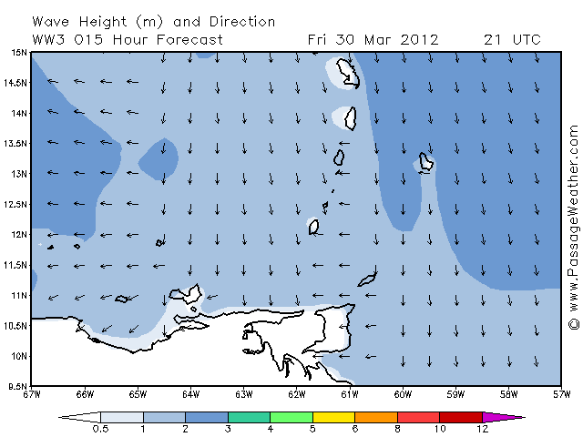
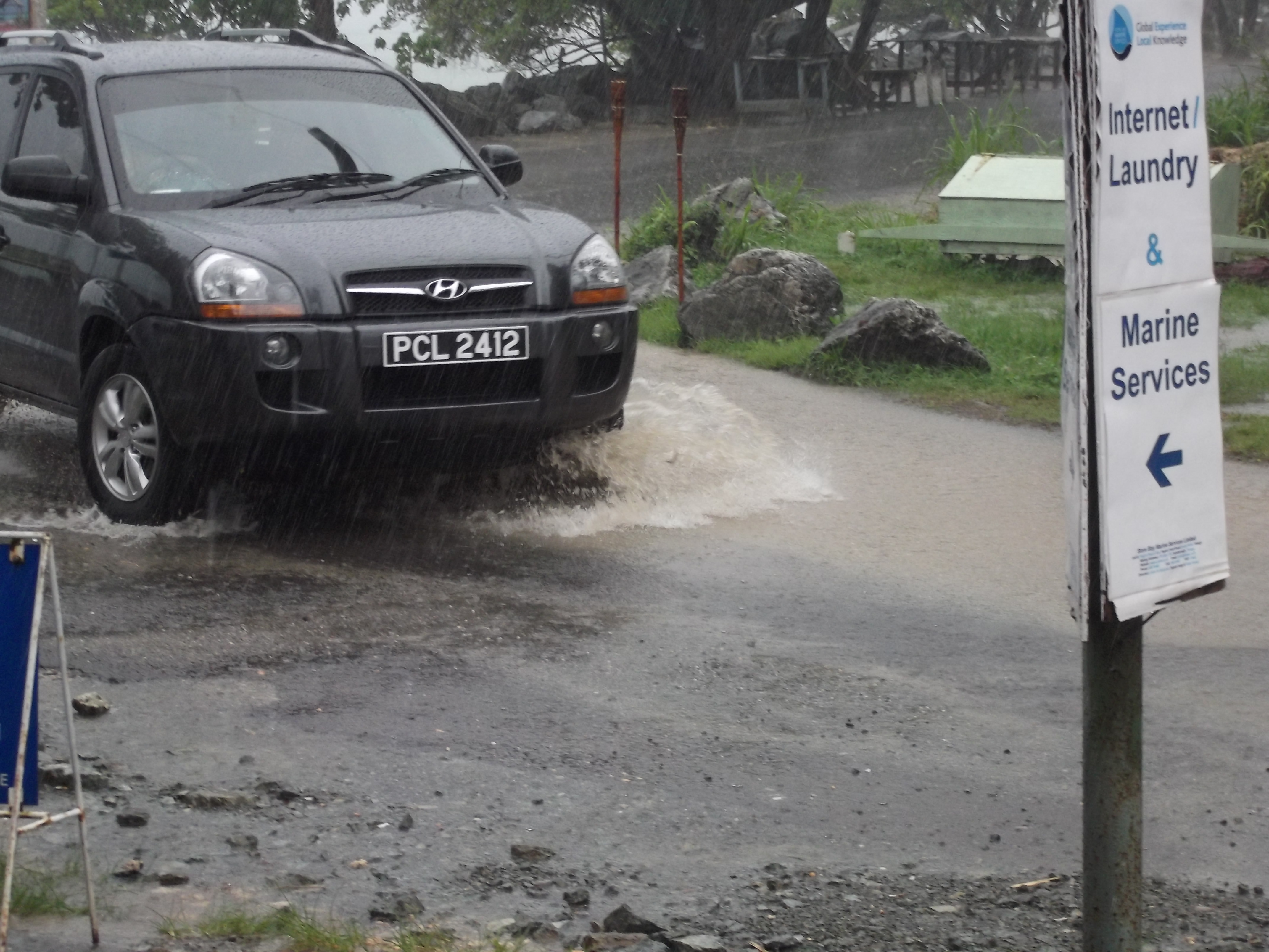
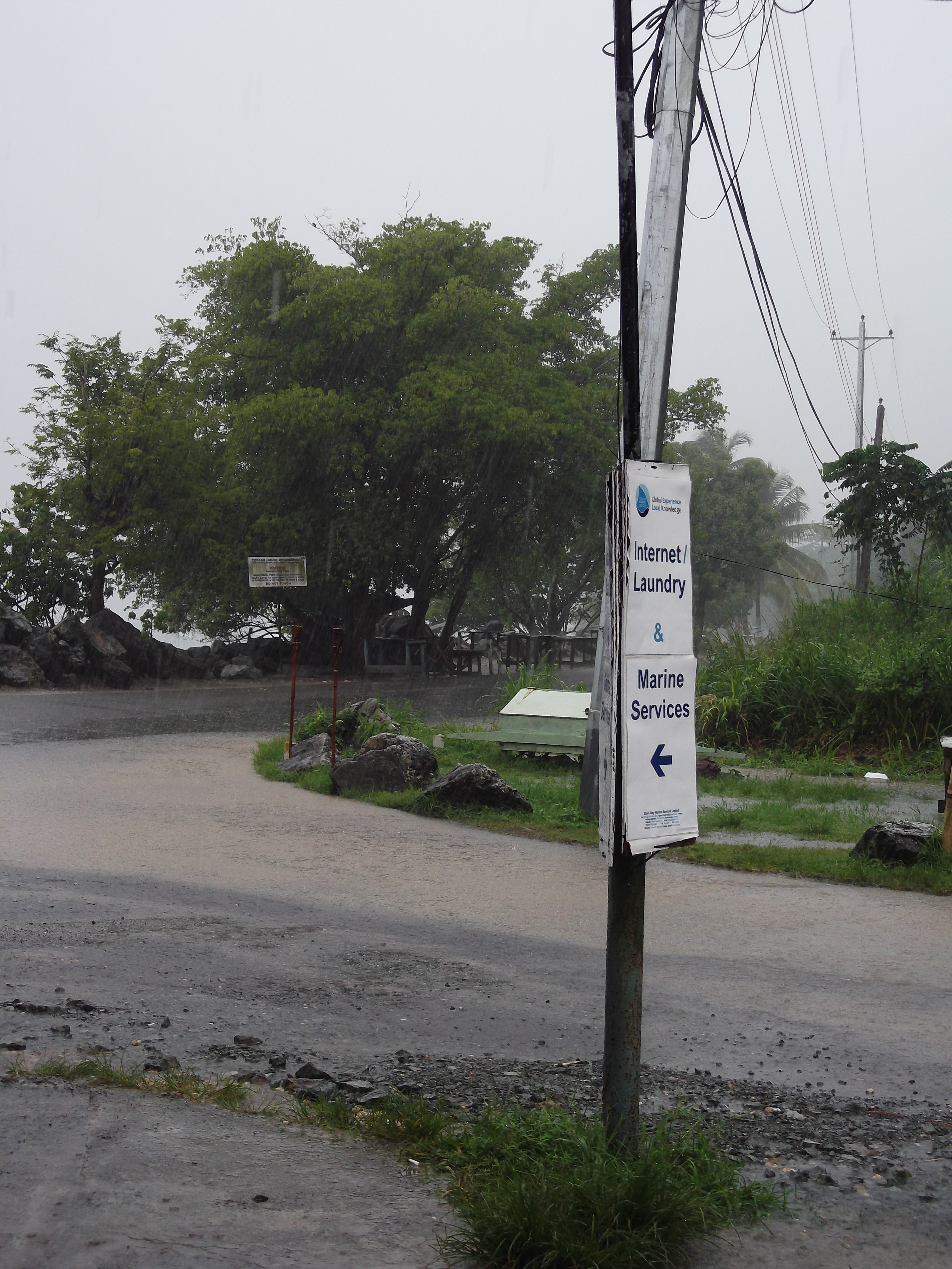
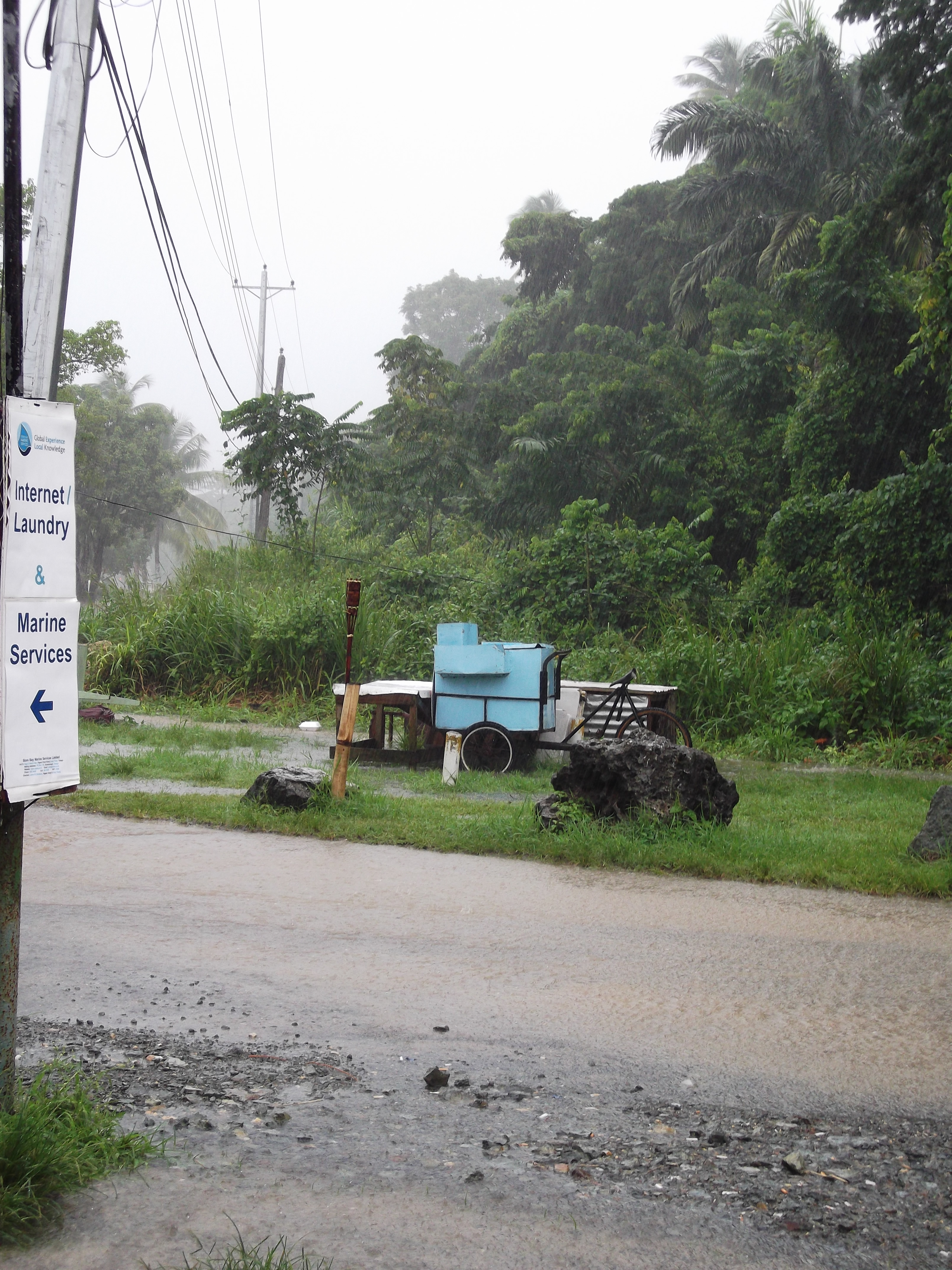
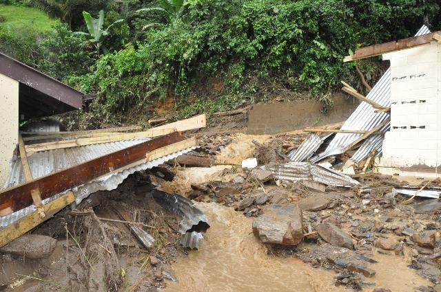
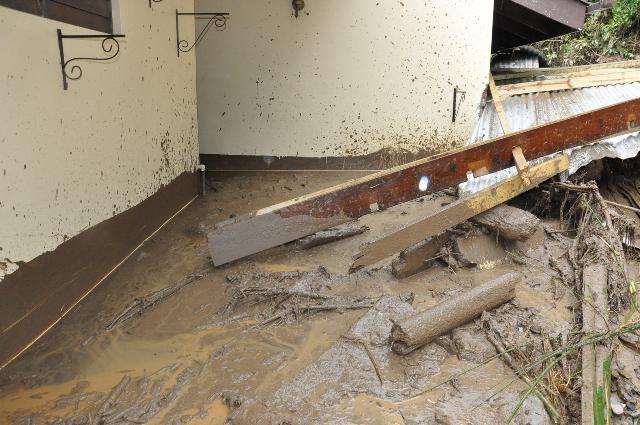
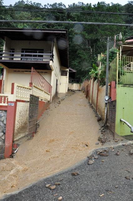
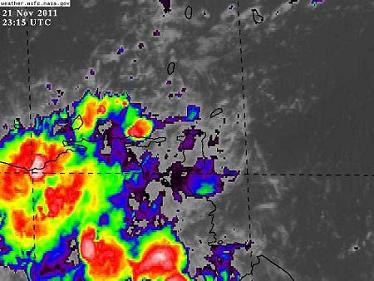
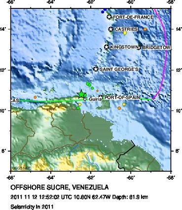
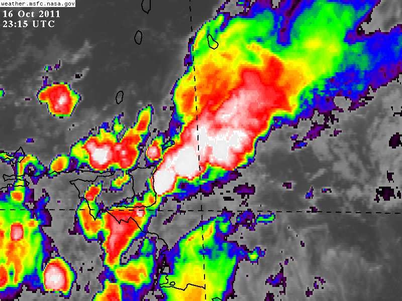
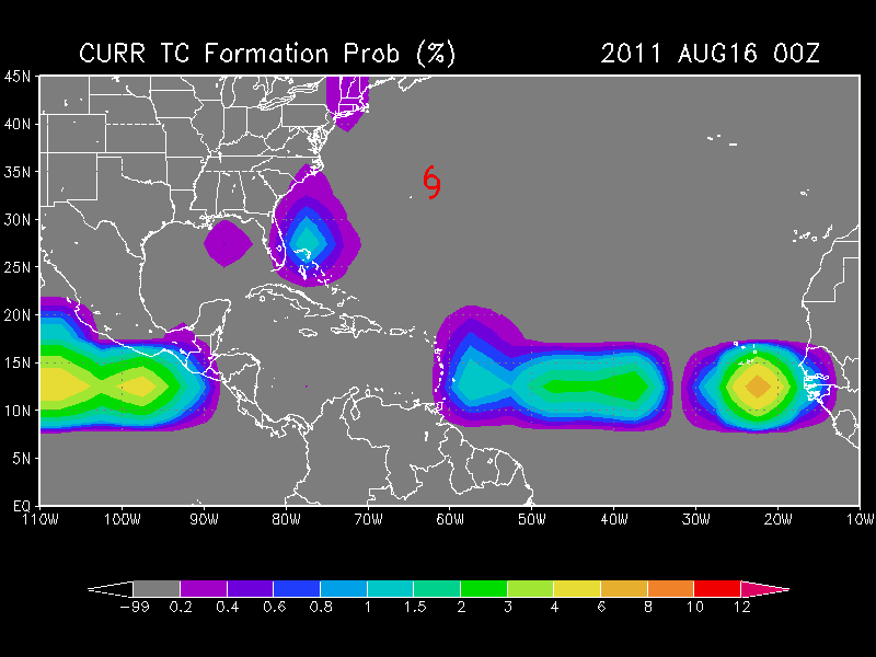
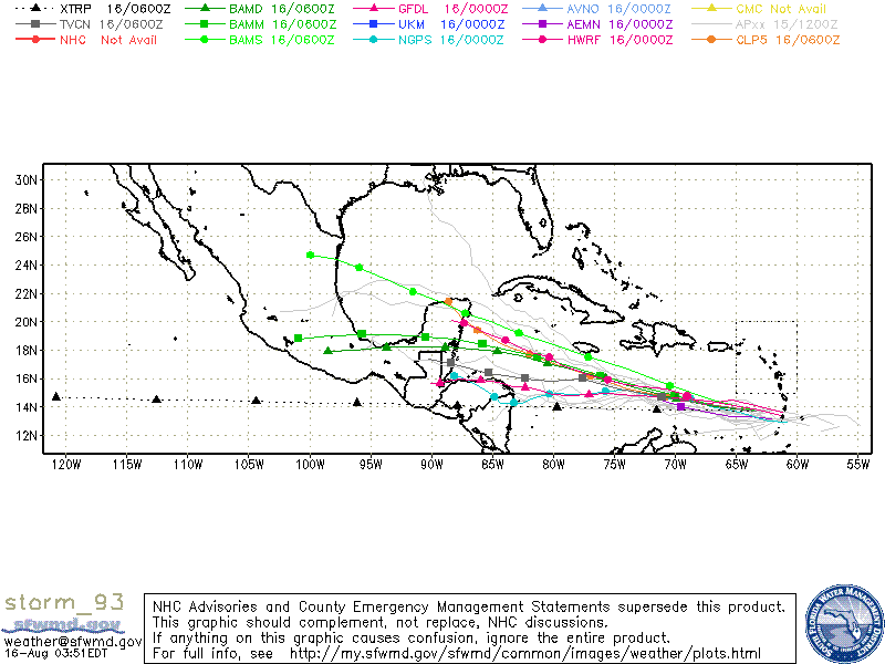