|
For the most recent reports from the Bahamas see this page.
- - - 2011 Hurricane Season - - -
|
- Long Island
|
- By Gert van Dijken <gert at vandijken.com>
- Date: Thu, 25 Aug 2011 09:36:56 -0700
|
Received the message below from David Sherwin regarding Long Island. If anyone has more news or sources of information regarding Long Island or other islands let me know and I'll post it here...
--
Gert van Dijken
Caribbean Hurricane Network
http://stormcarib.com
On Thu, Aug 25, 2011 at 8:03 AM, David Sherwin wrote:
Thank YOU for your website!
My dad got through to our neighbours on northern Long Island today. There was a high storm surge and we've got (sea)water in our house, but fortunately the roof held. Our neighbour had some roof damage, but it doesn't sound to be nearly as bad as what was suffered on the eastern side of the island.
David
|
|
- New providence
|
- By angelaculmer at gmail.com
- Date: Thu, 25 Aug 2011 13:47:31 +0000
|
Well the winds are raging
We have a downed tree and no power
Despitethis we are safe
Listening to the radio people have stayed indoors
God Bless
Angela
Sent from my BlackBerry® wireless device available from BTC.
|
|
- Other news stories
|
- By Gert van Dijken <gert at vandijken.com>
- Date: Thu, 25 Aug 2011 07:14:31 -0700
|
The Nassau Tribune has some updates on the storm: http://www.tribune242.com/
--
Gert van Dijken
Caribbean Hurricane Network
http://stormcarib.com
|
|
- Oh Irene!
|
- By "Anita Rolle " <anitarolle at hotmail.com>
- Date: Thu, 25 Aug 2011 12:55:33 +0000
|
Good morning world. The winds and rain picked up considerably through the
night. Continuously now since about 2am we've been pounded by this hurricane.
The power company have done scheduled outages in certain areas - mine in
Eastern Nassau just happened to be one so I've been without power now since
around 3am.
According to news reports this morning there is already structural damage
around the island, and downed power lines in some areas. However, no reports of
lives lost, and we're gonna keep it that way!
We are not feeling all we're going to get from this yet. Will continue to
update for as long as I can. Will continue to PRAY.
Sent from Anita's BlackBerry® wireless device available from BTC.
|
|
- Update
|
- By angelaculmer at gmail.com
- Date: Thu, 25 Aug 2011 13:44:35 +0000
|
Sent from my BlackBerry® wireless device available from BTC.
|
|
- New Providence,
|
- By angelaculmer at gmail.com
- Date: Thu, 25 Aug 2011 03:03:30 +0000
|
Good Evening
It was heartening this evening to listen to the local radio and hear about all
the assistance that is available for all residents
We are playing the waiting game although the breeze has picked up
We have been advised to stay indoors and we are adhering to that advice
The power has been coming on then off
We are in contact with family members in Eleuthera who are prepared and
anxiously waiting for the arrival of Irene
Thank for the prayers and we wait for tomorrow
God Bless
Angela
Sent from my BlackBerry® wireless device available from BTC.
|
|
- IRENE UPDATE
|
- By "Ms. Hogg" <bahamastutor at live.com>
- Date: Wed, 24 Aug 2011 23:00:40 -0400
|
|
Good Day from New Providence.
Earlier today the roads were crowed with last minute shoppers preparing for Irene. Now, at 11pm the wind has picked up considerably and there are frequent sqalls of heavy rain. There is also the infrequent deep rumble of thunder. The electricity and phone services are still on.
Folks have put up hurricane shutters and now await the heaviest portion of the storm.
So far no major issues. Let's hope it stays that way.
|
|
|
- San Salvador - 4:51 PM
|
- By "Jenni Barnes" <spscuba at gmail.com>
- Date: Wed, 24 Aug 2011 16:53:06 -0400
|
Winds are definitely picking up. Went outside earlier and the waves were at least 25 feet high. Not going back out unless we have too. All is good. Power was out for about an hour and a half. Have power, internet, and tv at the moment. Take care everyone |
|
|
- Nassau awaits Irene
|
- By "Anita Rolle " <anitarolle at hotmail.com>
- Date: Wed, 24 Aug 2011 17:18:12 +0000
|
As the southern Bahamas is currently being battered by Irene we here in the
northern Bahamas are waiting, patiently. At the eastern end of Nassau where I
am, were enjoying sunny skies. There are however, intermittent rain bands
accompanied by strong winds. Almost an erie feeling. One minute warm sunshine,
next minute dark clouds, wind and rain.
Most business establishments have been secured as well as residences. Everyone
is taking this one seriously. Its just a sit and wait period now. Waiting to
see exactly what Irene has in store for us.
God is a great God. This is gonna be a tough test of our endurance but we will
be fine. Pray.  :+)
Will continue to update as changes occur.
Sent from Anita's BlackBerry® wireless device available from BTC.
|
|
- 11/30am San salvador
|
- By Sandra Pitt <romperpitt at yahoo.com>
- Date: Wed, 24 Aug 2011 08:35:03 -0700 (PDT)
|
Winds are picking up now with more rain showers & my Sat Internet going in & out. I believe over Crooked island now so still a ways to go for us in the central Bahamas but will be down hill from now on will post again if i can Sandra Pitt.
|
|
|
- Hurricane Irene, Wednesday update (Bahamas)
|
- By "Kimberly King-Burns" <kkingburns at convergenz.com>
- Date: Wed, 24 Aug 2011 08:19:32 -0700
|
Wednesday update: Irene intensifies to a Category 3 hurricane, and San
Salvador, Mayaguana check in with damage to roofs and property so far.   The
eye continues to move east, and at this point is expected to miss New
Providence by 70+ miles.

http://www.tribune242.com/news/08232011_hurricanerolling_news_pg

Hazards affecting land
----------------------
wind...hurricane conditions are occurring over portions of the
southeastern Bahamas. Tropical storm conditions are expected to
begin over the central Bahamas within the next few hours...with
hurricane conditions expected by tonight. Tropical storm
conditions are expected in the northwestern Bahamas by late
tonight...with hurricane conditions expected on Thursday.

Storm surge...in areas of onshore winds near the center of
Irene...an extremely dangerous storm surge will raise water levels
by as much as 7 to 11 feet above normal tide levels over the
Bahamas. A storm surge of 5 to 8 feet above normal tide levels is
also possible in areas of onshore winds over the Turks and Caicos
Islands. Near the coast...the surge will be accompanied by large
and dangerous waves.

Rainfall...Irene is expected to produce additional rainfall
accumulations of 1 to 3 inches across Hispaniola with isolated
maximum storm total amounts of 15 inches possible. These rains
could cause life-threatening flash floods and mud slides in areas
of steep terrain. Rainfall accumulations of 6 to 12 inches are
expected in the Bahamas...and the Turks and Caicos Islands.

The Briland Modem
www.briland.com
News & Information for Harbour Island and North Eleuthera
|
|
- Wednesday From New Providence
|
- By Angela Culmer <angelaculmer at gmail.com>
- Date: Wed, 24 Aug 2011 06:14:08 -0400
|
|
Good Morning Driving through Nassau last night it was eerily quiet everyone was home and indoors.Most people seem to have completed preparations and I saw a Cruise ship leaving the Port. This morning we are up early anticipating some rain and wind and dreading power outages.
The pharmacies were busy yesterday as people were filling prescriptions. Despite this everyone is in good spirits and resolute in preparing to ride out the storm. Continue to pray for us
God Bless will continue to make posts throughout this day Angela
|
|
- Wednesday morning New Providence
|
- By Angela Culmer <angelaculmer at gmail.com>
- Date: Wed, 24 Aug 2011 06:13:54 -0400
|
|
Good Morning Driving through Nassau last night everything was eerily quiet with hardly any activity on the streets. I did see a Cruise ship leaving but everywhere else was unusually quiet
Most people have finished preparations. Hurricane shutters are up and cars safely parked at home. The pharmacies were busy with people filling prescriptions and finishing any last errands. The waiting is the worst anticipating the power outages and heavy wind.
Continue to remember us in prayer. God Bless I will continue to post as long as we have power! Angela
|
|
- San Salvador
|
- By Sandra Pitt <romperpitt at yahoo.com>
- Date: Wed, 24 Aug 2011 02:18:54 -0700 (PDT)
|
5/15am was fairly quiet night but still I didn't sleep good. Looked out the door & not too bad yet. The bad news is the central Bahamas are going to bare the Brunt of it so wish us luck as the day goes on. Will post as long as my Sat dish stays up. Sandra Pitt.
|
|
|
- WINDY Wednesday morning
|
- By Esther Marie Wells <estherw01 at yahoo.com>
- Date: Tue, 23 Aug 2011 23:57:39 -0700 (PDT)
|
It has been blowing steadily throughout the night and early morning. (I can't hold the door open by myself). But no rain yet. |
|
- San Salvador
|
- By Sandra Pitt <romperpitt at yahoo.com>
- Date: Tue, 23 Aug 2011 18:52:07 -0700 (PDT)
|
Well winds are starting to pick up can here the ocean from Snow Bay so we are hitting the sack early tonight for a long day tomorrow. Stay safe to all in The Bahamas we are thinking of everyone Take care Sandra,
|
|
|
- IRENE
|
- By "Ms. Hogg" <bahamastutor at live.com>
- Date: Tue, 23 Aug 2011 19:59:28 -0400
|
|
The sounds of hammering echo across the island of New Providence ( also called by the name of the capital city-Nassau). The streets were crowded as residents made last minute strom preparation purchases. A survey of t wo food stores showed low stocks of canned goods as consumers stocked up. The weather has been as hot as previous days,but with a persistant though light breeze. As the afternoon aged, a few dark clouds appeared but as of 7.57pm tonight, no rains. The echoes of distant hammers continues as we prepare to face IRENE.
|
|
|
- Hurricane Irene (Tuesday 7:00p EST Update)
|
- By "Kimberly King-Burns" <kkingburns at convergenz.com>
- Date: Tue, 23 Aug 2011 16:21:29 -0700
|
Baby steps, but Irene weakened to a Category 1 this afternoon ♥ http://www.
weather.com/weather/hurricanecentral/tracker ... cheers!

Kimberly

The Briland Modem, www.briland.com
News and Information for Harbour Island & North Eleuthera
|
|
- New Providence
|
- By Angela Culmer <angelaculmer at gmail.com>
- Date: Tue, 23 Aug 2011 18:55:48 -0400
|
|
I apologize I am reporting from New Providence and I will send updates as long as I have power.
|
|
- Hurricane Irene
|
- By Angela Culmer <angelaculmer at gmail.com>
- Date: Tue, 23 Aug 2011 18:49:29 -0400
|
|
Good Evening All At the moment many preparations are taking place with lines at the Gas stations and in the food store. This hurricane is being taken very seriously and most people are actively preparing our storm shutters are up and the boat is being secured as we speak.
many fishermen have returned to their respective homes as we avidly watch the Weather channel, check the internet for the latest updates. We remain in prayer for all in the midst of this strong Hurricane.
One good thing is that the information keeps oncoming and we are fully informed on what to do where to go and how to complete preparations. God Bless Angela
|
|
- San Salvador
|
- By "Jenni Barnes" <spscuba at gmail.com>
- Date: Tue, 23 Aug 2011 14:56:12 -0400
|
Hi all – house shuttered, boat secure, as well as other items. Had a huge “feeder” earlier, lot of rain and wind. Seas are kicking. Will be with Sandra Pitt thru the storm. |
|
|
- Grand Bahama
|
- By "katybel taylor" <katybel86 at gmail.com>
- Date: Tue, 23 Aug 2011 17:36:04 -0400
|
This Grand Bahama Reporter is currently on vacation in the White Mountains of New Hampshire. We send our prayers and hopes that she continues to track East to Grand Bahama and to all of the Islands in Irene’s path. If she continues up the Northeast Corridor we will send reports of the weather up here. God Bless. |
|
|
- TUESDAY AFTERNOON - LONG ISLAND, BAHAMAS
|
- By Esther Marie Wells <estherw01 at yahoo.com>
- Date: Tue, 23 Aug 2011 14:30:16 -0700 (PDT)
|
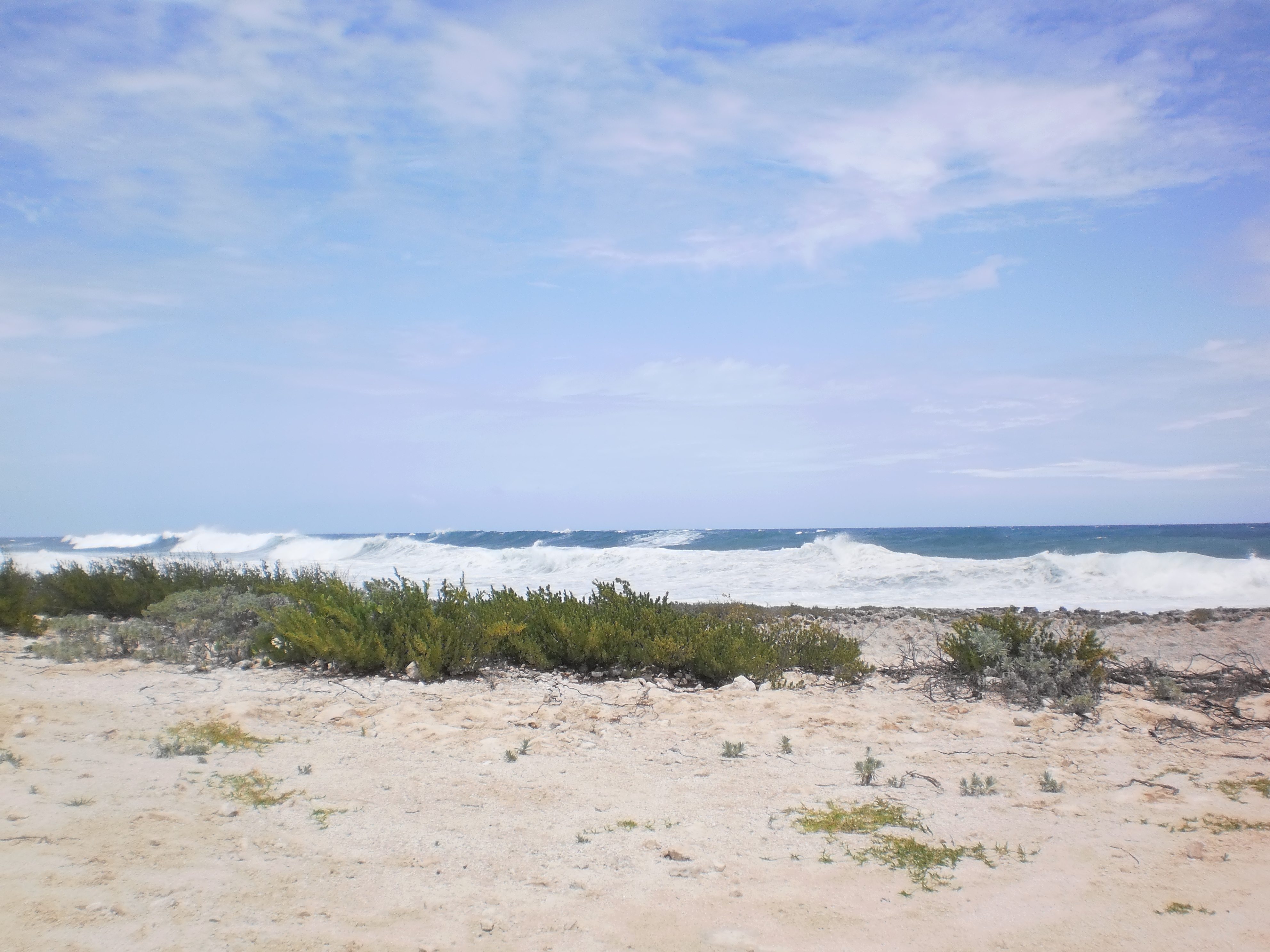
The day started out sunny and bright with a light breeze. This afternoon, the winds increased with the arrival of two or three outer bands also bringing a little rain. The seashore is taking a beating already.
A drive to the store revealed almost everyone has taken some precaution. Debris, flower pots, and boats are secured, windows and doors protected and I had to wait in line for gasoline.
Irene is expected to hit Long Island on Wednesday.
Keep safe all. I shall continue to post until the power goes out. Attachment:
P8230003.JPG
Description: JPEG image
|
|
- From San Salvador
|
- By Sandra Pitt <romperpitt at yahoo.com>
- Date: Tue, 23 Aug 2011 14:06:06 -0700 (PDT)
|
We have had some gusts & heavy rain so far I hear the shops are getting empty & water gone good job I keep ahead this time of year. I believe most people are ready now. Looks like we will start going down hill early morning & then 8pm tomorrow night. My husband is out doing last Minute things for some of our friends, the dogs & I inside cooking while the power is on .
Good luck to all the Bahamas & will keep posting as long as Possible.
Sandra Pitt.
|
|
|
- Bracing for Irene
|
- By "Anita Rolle " <anitarolle at hotmail.com>
- Date: Tue, 23 Aug 2011 19:06:05 +0000
|
Nassau is a bustle of activity as residents rush to make final preparations for
the impact of this hurricane.  Many business establishments are calling it an
early day to allow staff ample time to secure their properties & family.

There's a VERY light wind which u can really only distinguish by the slight
sway of the palm trees.  The weather is extremely warm - not a good sign for us
in this particular situation.  Will continue to keep you updated as changes
occur.

I'll say it again...PRAY. This promises to be a pretty rough ride for us.
Sent from Anita's BlackBerry® wireless device available from BTC.
|
|
- Tuesday
|
- By Sandra Pitt <romperpitt at yahoo.com>
- Date: Tue, 23 Aug 2011 07:43:02 -0700 (PDT)
|
Sandra Pitt wrote , Tuesday morning in San Salvador was very still to start with but now at 10/45 am the wind is picking up & the ocean has white caps & swells. We are all bracing down for what is to come it seems the whole Bahamas is going to be Impacted so fingers crossed for all & stay safe. Sandra .
|
|
|
- Irene!
|
- By Anita Rolle <anitarolle at hotmail.com>
- Date: Mon, 22 Aug 2011 22:40:43 -0400
|
Thanks for the well wishes Bert. Still quite calm in Nassau at the moment. Today was simply beautiful, the calm before the storm. Will update as the weather deteriorates. Not feeling so good about this one. Been tracking and forecasting (thank you Silbert) for awhile and this is the first system in a long time that REALLY has me worried. Pray!
|
|
|
- From San Salvador Bahamas
|
- By Sandra Pitt <romperpitt at yahoo.com>
- Date: Mon, 22 Aug 2011 18:29:59 -0700 (PDT)
|
All very still here tonight had a little rain. Most precautions taken. Sandra Pitt.
|
|
|
- BahamasWeekly: IRENE 2011
|
- By "Kimberly King-Burns" <kkingburns at convergenz.com>
- Date: Mon, 22 Aug 2011 16:21:36 -0700
|
http://www.thebahamasweekly.com/publish/bis-news-updates/Alert_10_on_Hurrica
ne_Irene17478.shtml?utm_source=twitterfeed&utm_medium=twitter

BAHAMAS INFORMATION SERVICES UPDATES
Aug 22, 2011 - 5:12:14 PM

 THIS IS ALERT NUMBER TEN (#10) ON HURRICANE IRENE ISSUED BY THE BAHAMAS
METEOROLOGICAL DEPARTMENT, AT 3:00PM MONDAY, 22ND AUGUST, 2011.

...IRENE IS MOVING AWAY FROM PUERTO RICO...HEADING TOWARD THE TURKS AND
CAICOS ISLANDS AND THE SOUTHEASTERN BAHAMAS ... A HURRICANE WARNING IS IN
EFFECT FOR THE SOUTHEAST BAHAMAS WHICH INCLUDES INAGUA, MAYAGUANA, CROOKED
ISLAND, RAGGED ISLAND AND ACKLINS. A HURRICANE WARNING IS ALSO IN EFFECT FOR
THE TURKS AND CAICOS ISLANDS.

A HURRICANE WARNING MEANS THAT HURRICANE CONDITIONS ARE POSSIBLE IN THE
MENTIONED ISLANDS WITHIN THIRTY-SIX (36) HOURS.

A HURRICANE WATCH IS IN EFFECT FOR THE CENTRAL BAHAMAS WHICH INCLUDES THE
ISLANDS OF LONG ISLAND, SAN SALVADOR, RUM CAY, CAT ISLAND, EXUMA AND ITS
CAYS.

A HURRICANE WATCH MEANS THAT HURRICANE CONDITIONS ARE POSSIBLE IN THE
MENTIONED ISLANDS WITHIN FORTY-EIGHT (48) HOURS.

AT 2:00 PM EDT, THE CENTER OF HURRICANE  IRENE WAS LOCATED NEAR LATITUDE
19.3° DEGREES NORTH AND LONGITUDE 68.1° DEGREES WEST OR ABOUT 247 MILES
EAST-SOUTHEAST (ESE) OF GRAND TURK, TURKS AND CAICOS AND ABOUT 356 MILES
EAST-SOUTHEAST (ESE) OF MATTHEW TOWN, INAGUA.

IRENE IS MOVING TOWARD THE WEST-NORTHWEST (WNW)NEAR 12 MILES PER HOUR AND
THIS MOTION IS EXPECTED TO CONTINUE DURING THE NEXT 24 TO 48 HOURS. ON THIS
TRACK THE CENTER OF IRENE WOULD BE MOVING JUST TO THE NORTH OF THE DOMINICAN
REPUBLIC AND HAITI TODAY...NEAR OR OVER THE TURKS AND CAICOS ISLANDS AND THE
OUTHEASTERN BAHAMAS TUESDAY...AND NEAR THE CENTRAL BAHAMAS ON WEDNESDAY.

MAXIMUM SUSTAINED WINDS REMAIN NEAR 80 MILES PER HOUR (MPH) WITH HIGHER
GUSTS. IRENE IS A CATEGORY ONE HURRICANE ON THE SAFFIR-SIMPSON HURRICANE
WIND SCALE. STRENGTHENING IS FORECAST DURING THE NEXT FEW DAYS.

HURRICANE FORCE WINDS EXTEND OUTWARD UP TO 30 MILES FROM THE CENTER AND
TROPICAL STORM FORCE WINDS EXTEND OUTWARD UP TO 185 MILES TO THE NORTHEAST
OF THE CENTER.

RESIDENTS IN THE SOUTHEAST BAHAMAS AND THE TURKS AND CAICOS ISLANDS SHOULD
RUSH TO COMPLETE PREPARATIONS TO PROTECT PROPERTIES.

RESIDENTS IN THE CENTRAL BAHAMAS SHOULD BEGIN TO TO MAKE THE NECESSARY
PREPARATIONS IN ADVANCE OF IRENE.

RESIDENTS IN THE WARNINGS AREA WHOSE DWELLINGS ARE NOT WARRANTED SOUND
SHOULD CONTACT THEIR LOCAL ADMINISTRATORS TO FIND SUITABLE SHELTERS.

SMALL CRAFT OPERATORS IN THE SOUTHEAST BAHAMAS AND TURKS AND CAICOS SHOULD
REMAIN IN PORT WHILE SMALL CRAFT OPERATIONS IN THE CENTRAL BAHAMAS SHOULD
NOT VENTURE FAR FROM PORT.

ALSO, RESIDENTS IN THE NORTHWEST BAHAMAS SHOULD CLOSELY MONITOR THE PROGRESS
OF HURRICANE IRENE AND ENSURE THAT ALL PRE-SEASON PRECAUTIONS HAVE BEEN
AKEN.

PREPARED BY FORECASTER SHAYVONNE MOXEY-BONAMY

© Copyright 2011 by thebahamasweekly.com -

---------------------------------------------------
The Briland Modem, www.briland.com
News & Information for Harbour Island and North Eleuthera (BAHAMAS)
|
|
- Monday - BEAUTIFUL DAY IN LONG ISLAND, BAHAMAS
|
- By Esther Marie Wells <estherw01 at yahoo.com>
- Date: Mon, 22 Aug 2011 16:09:51 -0700 (PDT)
|
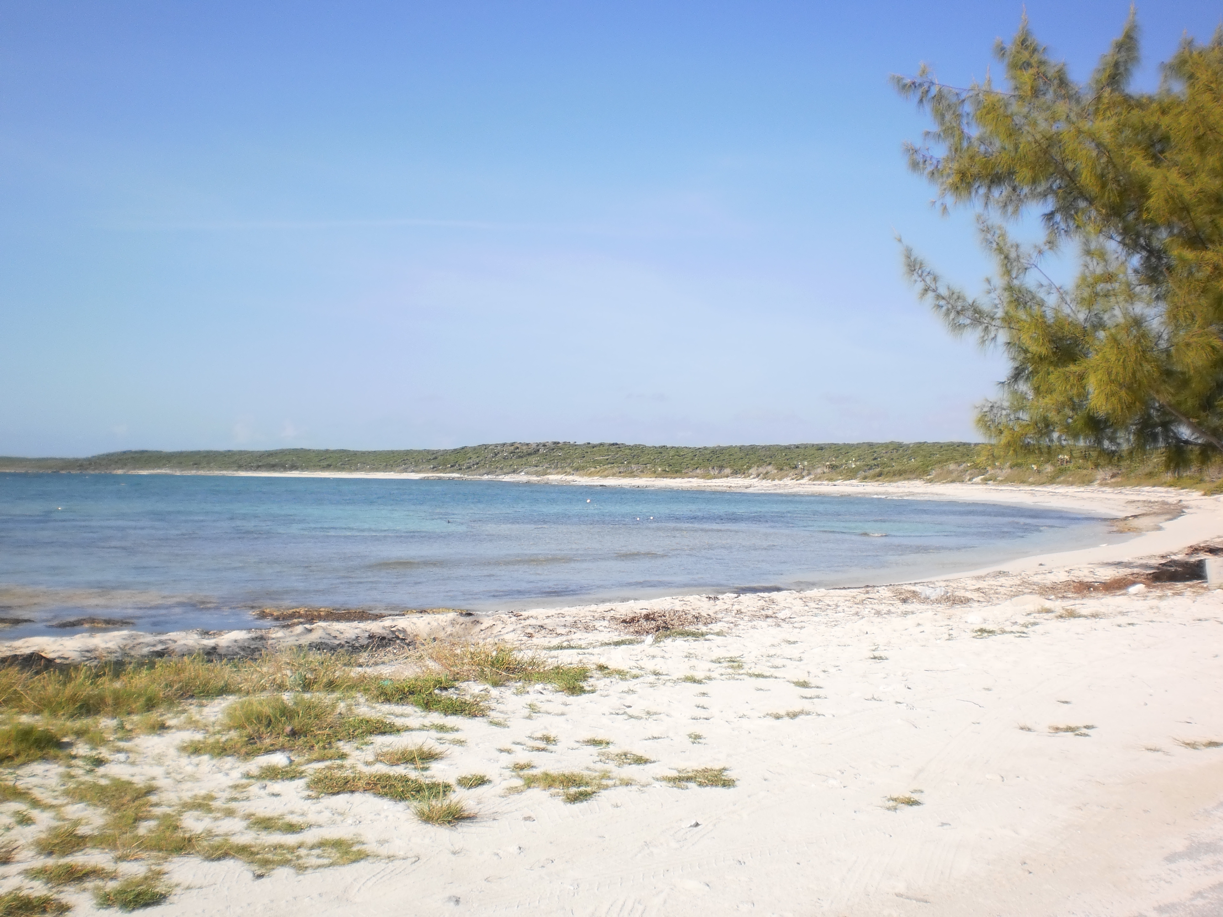
Warnings and Watches have been issued for the entire Bahamas. However, it was business as usual here on the island today, everyone seems to be waiting until the last minute.
Nervously anticipating the arrival of Hurricane Irene. Attachment:
P8220001.JPG
Description: JPEG image
|
|
- IRENE
|
- By "Ms. Hogg" <bahamastutor at live.com>
- Date: Mon, 22 Aug 2011 18:17:03 -0400
|
|
Good Day All, it is a hot yet breezy day in New Providence. The land is saturated already from the heavy rains we experienced over the past week. I have been watching Irene grow in size and strength. Now she seems to be headed right through the chain of islands here in the Bahamas. So far folks do not seem to be too worried. However I have observed some persons making hurricane preparation items.
I will keep you updated as long as we have internet service available. Let us pray that Irene loses her strength and turns away towards the open waters instead of towards inhabited lands.
|
|
|
