
|
For the most recent reports from Antigua see this page.
- - - 2009 Hurricane Season - - -
|
- BURKINA FASO
|
- From: "John Fuller" <fullerj at candw.ag>
- Date: Sun, 6 Sep 2009 19:04:46 -0400
|
WHILE WE IN THE CARIBBEAN DESPERATELY NEED THE RAIN THAT THE
SYSTEMS FROM AFRICA BRING US, BURKINA FASO, WHICH IS AT THE MOST EASTERN END OF
THE MAP ATTACHED, IS BEING FLOODED BY THE VERY SAME SYSTEMS THAT KEEP US GOING.
BURKINA FASO IS, AS I WRITE,
![[GOES/Meteosat Combi]](jpgIffV7HiuXH.jpg) SUFFERING FROM THE WORST FLOODS IN 90
YEARS. SUFFERING FROM THE WORST FLOODS IN 90
YEARS.
|
|
|
- Erika
|
- From: Ellen Deboeck <ellen at searchantigua.com>
- Date: Fri, 4 Sep 2009 09:09:08 -0400
|
Good Morning All,
It is going to be overcast for the entire day. It has stopped raining in St.John's for about an hour now. The weather will continue like for this probably into tomorrow and Sunday.
Keep you posted
Ellen
www.SearchAntigua.com
Follow us on Twitter: www.twitter.com/SearchAntigua
--
ellen at searchantigua.com
Search Antigua, Inc
Ph(268)561-0044
Cl(268)723-1188
Website Development & Internet Services
www.SearchAntigua.com
|
|
- About rain
|
- From: fullerj at candw.ag
- Date: Fri, 4 Sep 2009 02:47:46 +0000
|
My friend Alan "Squid" Hart has measured 6 inches of rain on the south east
side of the island since 2 am. Looks like we'll get some more tonight.
Sent from my BlackBerry® device from Digicel
|
|
- Opportunity to REST
|
- From: Ellen Deboeck <ellen at searchantigua.com>
- Date: Thu, 3 Sep 2009 11:11:58 -0400
|
Hi All,
As the rain continues to bless this twin island state, for many this is also an opportunity to rest and relax at home. So far, no damage reported and hope the power stays on!
Keep you posted
Ellen
www.SearchAntigua.com
Follow us on Twitter and Facebook
--
ellen at searchantigua.com
Search Antigua, Inc
Ph(268)561-0044
Cl(268)723-1188
Website Development & Internet Services
www.SearchAntigua.com
|
|
- Rain
|
- From: fullerj at candw.ag
- Date: Thu, 3 Sep 2009 14:59:38 +0000
|
Slept through all the fun. Sarah closed all the windows and doors at 2:30 am
while I snoozed. Quite a racket she says! Anyhow it's been steadily raining
ever since. Won't last much longer. A young LION now emerging off mama Africa!
Sent from my BlackBerry® device from Digicel
|
|
- RAIN!!!!
|
- From: jan farara <janfarara at hotmail.com>
- Date: Thu, 3 Sep 2009 14:09:27 +0000
|
Reminds me of England..the sort of rain that replaces the air, the sky a great grey white blanket. Cant see Jumby or the sea at all. Not too may leaks they were mostly from the wind blowing the rain under the corrugated roof and were very small. Need to fix them though. The power is back on again for about the 4th time since 10pm yesterday but the TV is off. No idea why it goes on and off like that. No waterfalls this time from the continuous rain just large puddles so far. Im not going out today but my husband will check later this morning and I hope there is not too much flooding .Our dog Max went out very briefly to take care of business and is now wet and spiky and content to stay in. Me too!!!!
With Windows Live, you can organize, edit, and share your photos.
|
|
|
- eye moves again! this time it looks like an eye tho
|
- From: eli fuller <elifuller at yahoo.com>
- Date: Thu, 3 Sep 2009 06:38:13 -0700 (PDT)
|
|
|
|
- Third morning
|
- From: Martha Watkins Gilkes <gilkesm at candw.ag>
- Date: Thu, 3 Sep 2009 09:35:35 -0400
|
Power still out... Our elect co says many areas r out. My Internet
still down xcept on my phone which is Gprs &very slow ...airport
opened this am. But lots of cancelled flts &delays.
Schools closed due to floods & lightening..taking a drive now to half
moon to ck waves &next door
   All in all. We r lucky no strong wind damage

Martha Watkins Gilkes
Sent from my Iphone
|
|
- Update Antigua and Barbuda
|
- From: Ellen Deboeck <ellen at searchantigua.com>
- Date: Thu, 3 Sep 2009 08:06:56 -0400
|
Dear All,
Rain, Rain and more rain. It has been raining for a few hours now in St.John's. It is not raining cats and dogs but continously at a slow speed. So far, we are doing ok.
Ellen
www.SearchAntigua.com
Follow us on Twitter: www.twitter.com/SearchAntigua
--
ellen at searchantigua.com
Search Antigua, Inc
Ph(268)561-0044
Cl(268)723-1188
Website Development & Internet Services
www.SearchAntigua.com
|
|
- No electricity
|
- From: Martha Watkins Gilkes <gilkesm at candw.ag>
- Date: Thu, 3 Sep 2009 03:32:37 -0400
|
Power gone...big time lightening & thunder ....pulled all of my
plugs .. Am on my. iPhone . Now 330 am. ...I long for sunrise...at
least my island wild kits all all in...3 of them..
Martha Watkins Gilkes
PO. Box W1924
Antigua, West Indies
268 460 4423 home
268 764 7722
Sent from my Iphone
|
|
- ERIKA 2 a.m...
|
- From: Martha Watkins Gilkes <gilkesm at candw.ag>
- Date: Thu, 3 Sep 2009 02:05:48 -0400
|
RAIN RAIN HAS COME... It has been a steady rain for some time now and my house is flooding as the rain runs down the hurricane shutters and comes under - not an ideal design!!! ... does not seem like much wind from INSIDE... but RAIN FOR SURE... and the odd bit of thunder. I just spoke to our Met Office and the main part of the storm has passed over Antigua and is in the Caribbean Sea, but there is a large cloud mass to the east that will continue to dump rain and the odd thunder storm on us for the rest of the dark and into the morning hours. They say the air port should open tomorrow.
In 1995 on SEPTEMBER 3rd and 4th we were facing the Catagory 4 HURRICANE LUIS that was so destructive so this is a walk in the park in comparsion.
There is concern for some of our low lying areas where homes could flood. I am on the highest hill on the Atlantic side of the island so flooding is not one of my personal concerns ( except under the hurricane shutters... and am already mopping that up! )... guess i will try to get some sleep.... |
|
|
- RAIN RAIN and kore RAIN
|
- From: Alan Scholl <scholla at candw.ag>
- Date: Thu, 3 Sep 2009 07:24:33 -0400
|
All was fairly quiet until 2:10AM when the heavens opened up. Heavy
rain, accompanied by strong gusts carried on until 3:40.
I awoke at 6 to an interesting "sunrise" coloured sky. The rain has
started again, it is not heavy but constant. If this continues we
could see some flooding.
Sat maps and GUA Radar shows us in theiddle of a large cloudass so it
will be like this for the remainder of the day and night.
Alan Scholl

Sent from my iPod Touch
|
|
- RED SKY - ERIKA
|
- From: "MARTHA WATKINS GILKES" <gilkesm at candw.ag>
- Date: Wed, 2 Sep 2009 21:25:21 -0400
|
|
This is the amazing sky Eli spoke of in his earlier post.. Check back a few posts... The sky truly was electrified with this ELECTRIC LADY on the horizon.. She still has not strutted her stuff.. But the night is early... Lets hope she does not leave us disappointed without even a promise of rainfall! |
 |
Attachment:
IMG_1844.JPG
Description: JPEG image
|
|
- ERIKA
|
- From: fullerj at candw.ag
- Date: Thu, 3 Sep 2009 00:59:54 +0000
|
Flat calm,muggy and hot. Lightning on the horizon to the east. With a bit of
luck rain later.
Sent from my BlackBerry® device from Digicel
|
|
- Erika
|
- From: Steve Coghlan <steve at candw.ag>
- Date: Wed, 02 Sep 2009 20:59:26 -0400
|
Light winds from the NE. High clouds overhead,
but moon shining right through.
Still no sign of Erika!
|
|
|
- AIRPORT CLOSED
|
- From: Martha Watkins Gilkes <gilkesm at candw.ag>
- Date: Wed, 2 Sep 2009 20:28:29 -0400
|
| They closed our airport at 6 p.m... Last LIAT flights left at 5 p.m. heading south and I just spoke to one of the pilots who flew along the Leeward chain that is due to effected and it was totally calm.. they could only see about 30 miles due east so maybe there is still the teasing lady dancing around out there? This is one to "confuse the models" for sure.. LIKE LENNY in 1999 for those who recall that weird one.. Tomorrow our flights - at least LIAT wont start again until 9 to 10 am so this has sure messed up travel for our island hopping people... still hoping we will get at least some RAIN as the night goes on..... i am searching the bush every half hour for my 2 wild "island cats" -- found when tiny kittens from wild cat mothers.. in the bush... and even though they are "local savvy" would rather they did not spend the night with ERIKA!!! |
|
|
- I don't believe
|
- From: eli fuller <elifuller at yahoo.com>
- Date: Wed, 2 Sep 2009 15:55:36 -0700 (PDT)
|
Well after some chores i loaded up my windsurfing gear and expected some action on the north shore. Not only didn't we get enough winds but I got sunburned while i waited for something to happen. I don't think we had more than 18 knots for the whole day and still Erika which is supposed to be just to our SSW isn't saying much. What a lovely sunset and moon rise though with a wild array of colours almost looking like the colour IR sat map that shows the disorganised storm teasing us. To see a bright moon inside some brighter pink high cloud was quite something 20 minutes ago. I'm not sure we will get any more shows of light later on. The radar shows DA about to get some and some patchy rains scattered east and south east of us, but this troubled girl looks like she's about to call it a day. I doubt Erika will be a storm for much longer. I would hope we get at
least one thunderstorm out of her....but with her it's anyone's guess.
|
|
|
- Storm Alert - Tropical Storm ERIKA
|
- From: "MARTHA WATKINS GILKES" <gilkesm at candw.ag>
- Date: Wed, 2 Sep 2009 17:59:41 -0400
|
|
We have just been advised by our MET OFFICE that ERRATIC ERIKA -- who is truly a disturbed lady and does not know what to do as Eli pointed out.... She Has TURNED MORE SOUTH.. That rarely happens.. ( and all the models had her tracking NORTH!!- boy were they wrong)
But we are not complaining as that means she is not directly over our head.. .but all the islands south will be in the direct track... See below.. And we will surely get some of the rain ( we badly need) .... And some gusty wind... See below....
Just spoke to someone at our met office and he said MOVE OUTDOOR FURNITURE.. Was not even doing that although I actually have put up my metal HURRICANE SHUTTERS... Partly as an "exercise" to test installing as they have not been installed for several years. So rushing around my garden moving a few "BLOWABLE things"... Will check in with you later... They say we wont start feeling things until late tonight...
Martha...
Subject: TSR Storm Alert - Tropical Storm ERIKA
Storm Alert issued at 2 Sep, 2009 21:00 GMT
Tropical Storm ERIKA is forecast to strike land to the following likelihood(s) at the given lead time(s): Yellow Alert Country(s) or Province(s) Guadeloupe probability for TS is 100% currently Dominica probability for TS is 100% currently Martinique probability for TS is 100% currently St. Lucia probability for TS is 100% currently Antigua and Barbuda probability for TS is 95% within 9 hours |
 |
|
|
- Erika looking a little ragged
|
- From: Allan D <top_shatta_ad2002 at hotmail.com>
- Date: Wed, 2 Sep 2009 12:35:20 -0400
|
After waking up this morning, I wasn't surprised to find a confused looking Erika limping towards the Leeward Islands. Since I last monitored the system around 3:30 this morning, the overall structure has continued to degrade further with a lost of symmetry, less banding motions and dissipating convections. It also looked as if the main convective cover has been displaced to the south-east of the center again. It should be noted that within the last two hours or so, the strong convection furthest south(which is ENE of Barbados) has begun to warmed up while stronger convective activity is developing closer though still a bit south and east of the center. This appears to be Erika's attempt to reorganize itself, but whether this will be successful, only time will tell. The shear is obviously still there but the ocean is relatively warm which continues to help fuel the convective bursts near the center before being sheared off. It stands that Erika has a 50-50 chance of weakening further or maintaining its strength for the time being. Due to it's weak shallow state, the storm will continue westward at a slow speed for another 6-10 hours or so. Also, a chance for the tropical storm to re-strengthen is still possible once and if the storm manage to reorganize.
The recent reformation of its center and the current motion means that the storm will pass within 65 miles of Antigua and Barbuda, it looks now that even Guadeloupe may get a piece of Erika. However, unless Erika re-strengthens, there won't be much of a sustained tropical storm conditions for any of the Leeward Islands per-se. Any strong winds will come in the form of squalls where it could reach 50 mph gusts especially to the northeast of where the center passes the islands. There will definitely be heavy rainstorms with up to 6-7 inches possible with higher amounts the longer it takes to pass.
There are also several vortices associated with the larger rotation of Erika. In visible imagery, it is evident that one of these low level swirls passed right over Guadeloupe earlier this morning!
It is interesting to note that the area where Erika is passing through now seems like the Bermuda Triangle for storm systems. Not so much in the long term but if you look at the past 7 years or so, you will noticed that many hurricanes, tropical storms or depressions approaching the Leeward Islands have either weakened or dissipated altogether, some only to reform/re-strengthen after clearing the 63˚W line. Very weak storms have also appeared virtually out of nowhere in this area, but they usually remain weak until after moving past or near Puerto Rico. This is quite interesting...
|
|
|
- 11 am update
|
- From: eli fuller <elifuller at yahoo.com>
- Date: Wed, 2 Sep 2009 07:58:11 -0700 (PDT)
|
"AT 1100 AM AST...1500 UTC...THE CENTER OF TROPICAL STORM ERIKA WAS
ESTIMATED TO BE NEAR LATITUDE 16.5 NORTH...LONGITUDE 60.4 WEST OR
ABOUT 100 MILES...165 KM...EAST-SOUTHEAST OF THE LEEWARD ISLANDS.
ERIKA IS MOVING TOWARD THE WEST NEAR 10 MPH...17 KM/HR. A WEST-
NORTHWESTWARD MOTION IS EXPECTED TO BEGIN LATER TODAY. ON THE
FORECAST TRACK...ERIKA WILL BE MOVING THROUGH THE LEEWARD ISLANDS
TONIGHT AND TOMORROW.
MAXIMUM SUSTAINED WINDS HAVE DECREASED TO NEAR 40 MPH...
65 KM/HR...WITH HIGHER GUSTS. LITTLE CHANGE IN STRENGTH IS FORECAST
TODAY WITH SOME SLIGHT RESTRENGTHENING POSSIBLE TOMORROW.
TROPICAL STORM FORCE WINDS EXTEND OUTWARD UP TO 105 MILES...165 KM
MAINLY TO THE EAST OF THE CENTER.
"
|
|
|
- Erika didn't take her meds
|
- From: eli fuller <elifuller at yahoo.com>
- Date: Wed, 2 Sep 2009 07:10:36 -0700 (PDT)
|
This lady is needs to see a therapist. She's totally unstable and i would even say schizophrenic. One minute she shows one personality and you think you have her figured out and then the next minute she looks like someone totally different. Each time i look at the sat motion maps she changes size, direction and shape. The radar shows some good convection stretching all the way down to Barbados and north and east from there up to us. So far we have just seen little squalls the strongest being in the early morning hours last night. I have secured the boats and now am gonna make my way to the north coast to collect my windsurfing gear. Jabbawock beach may be the spot for a little sport later. It's still a bit too light at this hour with winds probably about 15-20 on average. I think we have to keep thinking that there is a chance of 60 mph winds in thunderstorms
and squalls later today and tonight, but hopefully it won't be that bad. Erika looks sometimes like it's gonna fizzle out, but that's just one of her personalities. Dont be fooled by this shifter!
|
|
|
- STORM COMING
|
- From: "MARTHA WATKINS GILKES" <gilkesm at candw.ag>
- Date: Wed, 2 Sep 2009 09:28:14 -0400
|
People are finally taking this a bit more serious with the track presently coming more direct towards Antigua and Barbuda. We have to be aware in case it does strengthen as there seems to be much uncertainty in this storm! We are certainly hoping for badly needed 
Standing by .....
Martha |
 |
|
|
- Waiting for Erika
|
- From: Steve Coghlan <steve at candw.ag>
- Date: Wed, 02 Sep 2009 08:54:45 -0400
|
Erika has kept us all guessing for the last few
hours, and seems to be intent on doing so for a while yet. There is
much talk in official circles about multiple centers and reformation of
the center, but it just seems to me as if they do not really have a
handle on this storm yet.
Winds are N Easterly at 16 to 18 knots with higher gusts. Rain in
squalls and patches of sunshine and blue sky. Seas are rough and there
seems to be a swell running from the east as expected.
We continue to await Erika's passing!
|
|
|
- ERIKA
|
- From: "John Fuller" <fullerj at candw.ag>
- Date: Wed, 2 Sep 2009 07:15:24 -0400
|
LOOKS LIKE WE’LL GET A TOUCH OF ERIKA TODAY.
|
|
|
- Update
|
- From: Ellen Deboeck <ellen at searchantigua.com>
- Date: Wed, 2 Sep 2009 07:10:41 -0400
|
Good Morning All,
Completely overcast in St.John's and it started to drizzle on and off about 25 minutes ago. Let's see how this continues throughout the day. Keep you posted.
Ellen
268-779 0243
www.SearchAntigua.com
Twitter: www.Twitter.com/SearchAntigua
--
ellen at searchantigua.com
Search Antigua, Inc
Ph(268)561-0044
Cl(268)723-1188
Website Development & Internet Services
www.SearchAntigua.com
|
|
- Wind gusts
|
- From: Alan Scholl <scholla at candw.ag>
- Date: Wed, 2 Sep 2009 05:58:55 -0400
|
The wind is gusty but not constant. There are lulls with an occasional
period of windy spells.it is quiet at the moment.
Alan

Sent from my iPod Touch
|
|
- Erika moving West! TS Warning likely...
|
- From: Allan D <top_shatta_ad2002 at hotmail.com>
- Date: Wed, 2 Sep 2009 03:36:24 -0400
|
It appears that after stalling for a few hours, tropical storm Erika has choosen a more western path heading for the northern Leeward Islands. However, it is expected that the storm will resume its WNW track within the next 6 hours which also depends on whether Erika will maintain its organization. During the past few hours(since around 11:00 EDT), the convective structure and intensity have changed little but there seems to be some warming of the clouds near where the center should be. A 0600Z pass from the hurricane hunter suggests that the circulation center may've been trying to reform to the west. This may've caused some disruption in the low level circulation but the general system especially the upper level structure remains fairly well defined. Assuming that the convection does not warm further and the shear lightens a bit, the chances for the storm to intensifies exists.
Given the recent western jump and the current state of Erika, the TS is now expected to pass within 100 NM of Antigua and Barbuda. Hence, a tropical storm warning is now warranted for most of the northern Leeward Islands that were placed under watches earlier. On its projected path, Barbuda may be close enough to the core of Erika to experience some sustained tropical storm conditions while Antigua is still expected to receive mostly rain and squalls. This is, of course assuming that a WNW track will resume within the next 12 hours and the storm doesn't strengthens which is quite a possibility. In any case, all residents in the watch area should remain alert and be prepared for any scenarios. Since Erika could be a minimal hurricane at most, damages even in the event of a direct hit would be neglegible...provided that preparations are complete.
|
|
|
- NHC must be looking at the Pacific?!?!?
|
- From: eli fuller <elifuller at yahoo.com>
- Date: Wed, 2 Sep 2009 00:09:20 -0700 (PDT)
|
Ya gotta love how wrong the NHC seems to have been on Erika so far. To me it looks like they and others have made some huge mistakes over the past 6 hours and that's even with two hurricane hunter fly throughs. The latest images show the storm way further south than they said it would be and i am sure that I could have done more to prepare for tropical storm winds which i am expecting later today. Lets hope i am wrong but that thing can't be at 17 already can it? Check this image: Also, if at 3 am (now) you put the radar images in motion here: http://www.meteo.fr/temps/domtom/antilles/pack-public/animation/animMOSAIC2.htmlIt looks like the middle of the storm is east of GP and hardly moving. Even if it moves NW and not WNW then the centre will pass over Barbuda. I think we should assume that there is a very high chance of flooding and tropical storm winds (35 - 64 knots) within 24 hours or sooner. Erika isn't doing what they thought it would do and those models are showing some weakness here. I hope they figure out why they were not more on top of this one as i don't think many people here in Antigua know about this or are prepared in any way.
|
Attachment:
GOES06152009245kxLFDl.jpg
Description: JPEG image
|
|
- ERIKA WHA YA
|
- From: "John Fuller" <fullerj at candw.ag>
- Date: Tue, 1 Sep 2009 23:44:27 -0400
|
TROPICAL
STORM ERIKA DISCUSSION NUMBER 2
NWS
TPC/NATIONAL HURRICANE CENTER MIAMI FL AL062009
1100
PM AST TUE SEP 01 2009
AN
AIR FORCE RECONNAISSANCE PLANE HAS BEEN TRAVERSING ERIKA AND
FOUND
THAT THE CENTER HAS MOVED VERY LITTLE DURING THE PAST SEVERAL
HOURS.
THE CIRCULATION HAS BECOME BETTER ESTABLISHED AND THE
MINIMUM
CENTRAL PRESSURE FROM A DROP WAS 1004 MB. THIS VALUE COULD
BE
A LITTLE BIT LOWER SINCE THE DROP MEASURED 19 KNOTS AT THE
SURFACE.
THE SFMR AND THE PLANE MEASURED 55 AND 50 KNOTS...
RESPECTIVELY...TO
THE NORTHEAST OF THE CENTER. THEREFORE...THE
INITIAL
INTENSITY IS SET AT 50 KNOTS. THERE HAS BEEN AN INCREASE IN
CONVECTION
NEAR THE CENTER AND THERE ARE SOME INDICATIONS FROM THE
HIGH-CLOUD
MOTION THAT THE SHEAR HAS LESSENED A LITTLE BIT. ERIKA
COULD
STRENGTHEN SOME DURING THE NEXT DAY OR TWO. THEREAFTER...MOST
OF
THE GLOBAL MODELS HAVE STRONG UPPER-LEVEL WESTERLY WINDS OVER
ERIKA...A
PATTERN THAT IS NOT FAVORABLE FOR STRENGTHENING. IN
FACT...THE
OFFICIAL FORECAST CALLS FOR WEAKENING DURING THAT PERIOD
AS
OPPOSED TO THE GFDL AND HWRF THAT BOTH MAKE ERIKA A STRONG
HURRICANE.
ERIKA
HAS BEEN MOVING VERY LITTLE DURING THE PAST FEW HOURS...BUT
THIS
COULD BE THE RESULT OF THE CYCLONE BEING IN ITS FORMATIVE
STAGE.
ERIKA IS LOCATED ON THE SOUTHWESTERN EDGE OF THE
AZORES-BERMUDA
HIGH AND THE CYCLONE SHOULD BEGIN TO MOVE TOWARD THE
WEST-NORTHWEST
OR 300 DEGREES AT 7 KNOTS ON WEDNESDAY. BECAUSE THE
AZORES-BERMUDA
HIGH IS FORECAST TO EXPAND WESTWARD A LITTLE
BIT...ERIKA
SHOULD MAINTAIN THIS WEST-NORTHWEST TO NORTHWEST TRACK.
SINCE
THE STEERING CURRENTS ARE NOT VERY STRONG....ERIKA SHOULD
MOVE
SLOWLY. GUIDANCE IS NOT IN GOOD AGREEMENT AND THE CONFIDENCE
IN
THE FORECAST TRACK IS LOW. BOTH THE UK AND THE GFS TAKE A MORE
WESTWARD
TRACK WHILE THE OTHER MODELS SHOW A MORE NORTHWESTERLY
COMPONENT.
THE OFFICIAL FORECAST IS VERY CLOSE TO THE CONSENSUS
WHICH
IS CENTERED BETWEEN THESE TWO MODEL OPTIONS.
|
|
|
- Erika strengthening...
|
- From: Allan D <top_shatta_ad2002 at hotmail.com>
- Date: Tue, 1 Sep 2009 22:44:32 -0400
|
Latest IR images shows a well organized TS Erika with expanding convective cover and cold cloud top temperatures reaching -80˚ C. The recent increase in convection over the center, improving outflow noted on WV imagery and banding features all indicate that the tropical storm is in a strengthening phase. It is quite obvious now that Erika was better organized and stronger than it was this afternoon. Further intensifications are likely within the next 12-24 hours and Erika could be a strong tropical storm by Wednsday with at least 60 mph winds or higher. There's even a chance that it could develop into a hurricane while passing north of the Leeward Islands. A deep trough currently seen over Florida can impair some shear on the storm later on.
Weak steering current are currently driving the storm on a very slow WNW track with a slight northward nudge over the past hour. This general track is expected for at least the next 24 hours. Due to its slow forward speed, there's a longer time available for it to intensify. The only inhibiting factor being dry air entrenchment and light shear. It's forward speed is expected to increase after 24 hours.
Erika is becoming a large tropical storm with force wind extending out to 100 NM from the center and QuikSCAT data suggest the wind field may be expanding even further. Even though Erika is expected to pass about 200 miles north of the northern Leeward Islands, gusty squalls and heavy rain can still be expected in the northern Lesser Antilles from Dominica to Puerto Rico. Stay tuned to NHC for more details.
|
|
|
- Convective burst!
|
- From: Allan D <top_shatta_ad2002 at hotmail.com>
- Date: Tue, 1 Sep 2009 19:42:38 -0400
|
During the past couple hours, there's been a massive burst of very cold top convection right over the center. This flare could be a cyclic event, in anycase, if the convection is persistent, it could be indicative that Erika is trying to intensify. If this is the case, it also means the wind field will become more symmetric and would likely expand as the storm gets stronger. It all depends on whether the convection will stay or weakens or even sheared off to the east again. If the convection remains vigorous for the next few hours, the NHC may consider raising Erika's intensity. Another ReconAir will be enroute to attempt another fix and give a better estimate tonight.
|
|
|
- ERIKA
|
- From: MARTHA WATKINS GILKES <gilkesm at candw.ag>
- Date: Tue, 01 Sep 2009 18:46:48 -0400
|
Title: ERIKA
Just catching up the various reports on ERIKA and I think we should all be very aware of what is literally on our door step. We are under a storm watch —on our met office hot line is warning us to all stay alert...and saying on the present course TOMORROW NIGHT we would get some heavy rains ( greatly needed) and some gusts... But they also say IF THERE IS NOT THE NORTH TURN it could be more.. So the next 24 hours is critical for us to stay alert and be aware! Glad I am not “walk about” in the Pacific or some far flung land..and home to keep the home fire burning! Just checked out this site to watch Erika in action.....
http://www.ssd.noaa.gov/goes/east/tatl/loop-avn.html
Martha Watkins Gilkes
Fanta-Sea Island Ltd.
“where dreams come true”
|
|
- ERIKA formed, heading north of Barbuda
|
- From: Allan D <top_shatta_ad2002 at hotmail.com>
- Date: Tue, 1 Sep 2009 17:58:39 -0400
|
As of 5:00 PM, Tropical Storm Erika was officially acknowledged. Current max. sustained wind is 50 mph moving towards the WNW(300˚) at a rather slow 9 mph. Since it is this close to the Leeward Islands, I'll merely use extrapolation to project its probable path which puts it at around 175 miles to the northeast of Barbuda at 12:00 PM EDT on Wednsday noon. This will be the closest point of approach but bare in mind that wobbling is still possible especially at this slow forward speed.
Intensity wise, it looks as if Erika will intensify somewhat in the next 12 hours. This is based on recent IR and visible imageries that show strong convections with -80 degrees cloud tops developing just to the east and partially over the center. If that trend continues and the center becomes completely covered, it would be likely that the storm will intensifies further. In fact, the probability for rapid intensification exists though at a rather low percentage. If it does occur, Erika could be near hurricane strength by the time it approaches the closest point of passage. I'm still expecting mainly rain for Antigua though there could be a few squalls with 40 mph embedded winds.
|
|
|
- ERIKA-- FINALLY
|
- From: "John Fuller" <fullerj at candw.ag>
- Date: Tue, 1 Sep 2009 16:56:33 -0400
|
http://www.nhc.noaa.gov/refresh/graphics_at1+shtml/204712.shtml?50wind120#contents
|
|
|
- Soon to be TS Erika
|
- From: Allan D <top_shatta_ad2002 at hotmail.com>
- Date: Tue, 1 Sep 2009 15:43:28 -0400
|
Last visible image(3:30 pm EDT) I've seen of Invest 94L show very impressive cirrus banding and a well defined low level banding cloud field usually associated with mid-range tropical storms. However a portion of the low level circulation center remained exposed though cold cloud tops are developing near the eastern semicircle. These are all indicative of an imminent tropical system formation. It is likely that TS warnings or watches will be issued as early as 5:00 pm EDT today. At the moment, I'm going through the Recon data coming in from the fly through and they are reporting pressure drops along with strong 45 kt winds at 500mb to the east of the supposed center. A closed circulation is yet to be determined. It is quite possible will be seeing Erika very soon.
Latest motion as determined by visible imagery and SCAT passes show a 310 motion or WNW. If this track continues, the center should pass just to the north of Barbuda. That said, it is still possible some of the gale force winds can affect portion of the Northern Leeward Islands tonight and tomorrow. Given the well defined nature of the system, most of the strongest surface winds should be within 35 miles of the center which means if it passes far enough to the north, Antigua would just simply get a good soaking and an impressive firework display.
|
|
|
- 94l
|
- From: "John Fuller" <fullerj at candw.ag>
- Date: Tue, 1 Sep 2009 07:34:46 -0400
|
MOST MODELS NOW SHOW A MORE NORTHERLY TRACK WITH 94L MISSING
US, BUT SEMPER VIGILANS.
|
|
|
- NW?
|
- From: eli fuller <elifuller at yahoo.com>
- Date: Tue, 1 Sep 2009 04:29:46 -0700 (PDT)
|
I'm looking at an aminate sat map of the storm just east of and I don't see it tracking north west. I think this thing isn't being given enough attention here in Antigua at all. It seems as though it's been long enough without a big storm to make people a little careless. I see all the models saying it will go North of the islands but this time i am not trusting. IT may be a mad scramble to get things sorted out later today. Keep checking it.
|
|
|
- HEADS UP!!
|
- From: "John Fuller" <fullerj at candw.ag>
- Date: Mon, 31 Aug 2009 23:58:26 -0400
|
3 LINES BELOW THE OPENING SATELLITE MAP OF THIS SITE YOU
WILL FIND THE MODEL PLOTS OF 94L. THERE ARE 2 SETS OF MODEL PLOTS ON WHICH YOU
CAN CLICK. THEY ARE USUALLY QUITE ACCURATE OVER THE DISTANCE THAT 94L IS FROM
US IN ANTIGUA AND BARBUDA TONIGHT. MOST OF THE PLOTS (CREATED BY
COMPUTERS) SHOW 94L COMING OVER US HERE IN ABOUT A DAY AND A HALF…SAY
WEDNESDAY. BY ALL ACCOUNTS IT WON’T BE VERY POWERFUL BUT IT HAS TIME TO
STRENGTHEN. IT MIGHT BE A GOOD IDEA TO PREPARE FOR A LOT OF RAIN AND SOME WIND.
IF IT DOESN’T HAPPEN, WELL AND GOOD, BUT RIGHT NOW IT IS A STRONG POSSIBILITY
IT MAY GO NORTH… BUT WHO WANTS TO ROLL THE DICE?
THE US NATIONAL HURRICANE CENTER HAS BEEN FOLLOWING STANDARD
PROTOCOLS BY DELAYING RAISING THE ALARM BECAUSE THE SYSTEM, UP TO 8 PM THIS
EVENING, HAS NOT MET THE CRITERIA TO BE LABELLED A TROPICAL STORM OR EVEN A
DEPRESSION ALTHOUGH THE CENTER HAS FOR SOME TIME NOW CAUTIONED US IN THE
LEEWARDS TO MONITOR 94L, BUT IT IS NOW TIME TO ACT AND TAKE PRECAUTIONS.
ALL SAILORS SHOULD SEEK SAFE HARBOUR AND SECURE THEIR
VESSELS.
THIS MAY ALL BE FOR NOTHING, BUT JUST IN CASE….
|
|
|
- PIA models
|
- From: eli fuller <elifuller at yahoo.com>
- Date: Mon, 31 Aug 2009 18:47:56 -0700 (PDT)
|
|
|
|
- super model's can be a PAI
|
- From: eli fuller <elifuller at yahoo.com>
- Date: Mon, 31 Aug 2009 18:47:21 -0700 (PDT)
|
Why can't the models decide where this invest will go? The latest shows it coming closer once again. I guess the only thing we can be happy about is that it's too close to strengthen into something super dangerous.........right? Anyway, like the NHC says we need to pay close attention to this one still. Better to be prepared just in case.
|
|
|
- nhc is telling us not to worry
|
- From: eli fuller <elifuller at yahoo.com>
- Date: Mon, 31 Aug 2009 14:28:12 -0700 (PDT)
|
The NHC still is calling the blob east of us an "invest" and now the models seem to be saying it's going north. Even the sat cloud maps make it look like its going NW. That being said it still looks very impressive for a tropical wave and since there is no low level circulation it's hard to figure out where the middle of the thing is. We should still keep an eye on it. I see in the St. Croix section that the weather people are issuing a slight warning for the weather expecting flash floods being a possibility even if it doesn't strengthen.
|
|
|
- Worried now
|
- From: eli fuller <elifuller at yahoo.com>
- Date: Mon, 31 Aug 2009 04:49:19 -0700 (PDT)
|
After what seems like ages, the "blob" east of us is starting to show signs that it has decided what it's doing. Invest 94L looked very good yesterday in the am and many of us thought we were seeing the further development of a storm. Then after dinner it kinda stopped spinning and looked like it was busting up. The NHC concurred but said that they still felt that it would strengthen and strengthen it did. By early this am it looked extremely impressive and had the CrownWeather.com saying that we here in the Northern Leewards need to prepare for a Tropical Storm. Looking at it now, i think he's right. WE NEED TO PREPARE FOR A TROPICAL STORM OR WORSE. Why wait until you are sure it's gonna hit us right? Anyway, many looking at it think that later today it will be a depression. For some reason it hasn't been named one yet. Sure looks like one. The hurricane
models still can't figure out what to do with it though, and i don't think we have seen an invest like this one for a long time. Hard to predict. Stay tuned!
|
|
|
- 94.L- INVEST = 1010 millibars
|
- From: Alan Scholl <scholla at candw.ag>
- Date: Fri, 28 Aug 2009 09:16:17 -0400
|
Another INVEST (94L) is crawling across the Atlantic. Maps
show the central pressure as 1010 mb.
As August ends and we head into the peak of the storm
season, these will be expected. Win Guru is showing 20
knots on Monday and StormSurf's models show it brusing us
once again as did BILL.
We will keep an eye on this one as per usual.

Do have a good weekend.

Alan B Scholl
www.digitalphoto.ag
|
|
- 94L is something worth watching...
|
- From: dorecia whyte <doreciawhyte at gmail.com>
- Date: Thu, 27 Aug 2009 13:51:38 -0400
|
|
Forecast models show 94L passing around this neck of the woods sometime middle of next week, and probably hurricane strength by then. Not good. It is worth watching. I trust that it does not find any 'favourable conditions' to aid its development. We certainly don't want a hurricane on our hands. The whole island chain has escaped any face-to-face encounters so far for the season and I really wish it will stay this way. Fingers crossed and knees bent. :)
|
|
- Freak Storm
|
- From: Ellen Deboeck <ellen at searchantigua.com>
- Date: Tue, 25 Aug 2009 07:56:40 -0400
|
Good Morning All,
We had a little freak storm yesterday. In a matter of minutes, the roads in St.John's were filled with water.
This morning, the sun is out and it is like it never happened. All is good and well on the islands of Antigua and Barbuda
Keep you posted.
Ellen
www.SearchAntigua.com
www.AntiguaWebsites.com
Follow us on Twitter: www.twitter.com/SearchAntigua
ellen at searchantigua.com
Search Antigua, Inc
Ph(268)561-0044
Cl(268)723-1188
Website Development & Internet Services
www.SearchAntigua.com
|
|
- 92L
|
- From: dorecia whyte <doreciawhyte at gmail.com>
- Date: Mon, 24 Aug 2009 14:00:55 -0400
|
|
I don't know if anyone else thinks so too, but 92L looks pretty impressive already for a tropical wave. The conditions may not be there for 'rapid' development, but already scary 'looking'. It's also taking the same basic path as Bill did so far. Looks like a WNW direction for the moment.
Dorecia Whyte
Antigua
|
|
- Wet morning
|
- From: Alan Scholl <scholla at candw.ag>
- Date: Mon, 24 Aug 2009 08:43:45 -0400
|
Was awoken at 4:20 with a large downpour and a bit of
wind. This continued on and off until just before leaving
for work. Around 7:15AM there were a few thunder rolls
causing the neighbourhood dogs to wake up indicated by
barking and howls.
The sun was peeking out when I got to work so could be a
mixed day, though I suspect we will be getting more rain
today.
Alan B Scholl
www.digitalphoto.ag
|
|
- tropical weather
|
- From: eli fuller <elifuller at hotmail.com>
- Date: Mon, 24 Aug 2009 12:26:56 +0000
|
last night dad told me that windguru was getting jumpy for the end of it's week long forecast. i jujst checked it and although i don't see the 28 knots that was there last night i do see some massive waves in their model for next monday. of course that's a week away but the computers are getting excited about some weather feature that they are working out. We should keep that in mind if planning a weekend trip.
Yesterday was filled with lovely weather and i'm sure all the other beach visitors had a nice one too. Today on the other hand started for me with thunder and from the looks of the radar, it's possible that there is more to come. My job is a pretty simple one but on days like this it's hard to tell what to do. Do i send a boat load of tourists out or not? It's nice and sunny now and hard to imagine that it will turn sour, but the radar and sat maps tell a tale that could be different. Being out on the boat when rains are pounding down around you is one thing but having flashes of intense light bright up the cloudy darkness is another. I cancelled the tour today so it will probably be nice and sunny. We'll see. The image below shows some weather just east of us. Tomorrow will be "more bettah".
www.sailing-antigua.com - Sailing Charters
+1268 725 7263 - The mobile
|
Attachment:
200908241215-Mosaique.gif
Description: GIF image
|
|
- wrong photo
|
- From: jan farara <janfarara at hotmail.com>
- Date: Sat, 22 Aug 2009 14:37:18 +0000
|
sent the wrong photo. Here is a better one. Jan
See all the ways you can stay connected to friends and family
|
Attachment:
The Wall.jpg
Description: JPEG image
|
|
- Bill's beauty
|
- From: jan farara <janfarara at hotmail.com>
- Date: Sat, 22 Aug 2009 14:00:34 +0000
|
We are very glad that Bill missed us and Bermuda, but I had to take time out on Wednesday afternoon to admire the sea's beauty and to take some photos. The sun shone through the surf and the spray as the waves pounded the reefs and in some cases came over into the bay. At one point the waves were hitting the rocks below me with really loud bangs and the waves threatened my work schedule,a minor consideration with hurricanes I know.!! I hate to think what a mess a closer encounter would have caused.The wall was finished on time and at a later date I'll paint Bill's waves and remember the feelings of awe. Jan
check out the rest of the Windows Live™.
More than mail–Windows Live™ goes way beyond your inbox.
More than messages
|
Attachment:
100_3926.jpg
Description: JPEG image
Attachment:
100_3911.jpg
Description: JPEG image
Attachment:
100_3912.jpg
Description: JPEG image
|
|
- HURRICANES and WHITE TIP SHARKS OF COCOS
|
- From: Gert van Dijken <gert at vandijken.com>
- Date: Wed, 19 Aug 2009 20:32:17 -0700
|
---------- Forwarded message ----------
From: Martha Watkins Gilkes
Date: Wed, Aug 19, 2009 at 6:40 PM
Subject: HURRICANES and WHITE TIP SHARKS OF COCOS
GOSH Serves me right to go "walk about " in hurricane season..was shocked to return from 10 day at sea from COCO ISLAND.. 400 miles off the pacific side of Costa rica..to learn of BILL about to hit "my paradise".... thank goodness it took the north turn..and makes me rethink going off on my adventures... however would be hard to miss the action we caught on film... shown here.. if viedo does not come out on this check me on facebook for the action...whites tips feeding at night! GLAD WE ARE ALL SAFE ON ANTIGUA... i am in miami so glad it is not coming this way either!! Will think twice before i "walk about " in September."
--
Gert van Dijken
Caribbean Hurricane Network
http://stormcarib.com
|
|
- Bill
|
- From: Steve Coghlan <steve at candw.ag>
- Date: Wed, 19 Aug 2009 19:29:32 -0400
|
Antigua is experiencing some rain showers from
the outer bands of Hurricane Bill.
Winds are shifting slowly from the North to a more Westerly direction,
and wind speed is about 8-10 knots.
Sea swells are large, and expected to be even larger by tomorrow.
Hopefully, we will get some much needed rainfall from the feeder bands
on the tail of the storm.
|
|
|
- massive or even larger
|
- From: eli fuller <elifuller at hotmail.com>
- Date: Wed, 19 Aug 2009 23:10:05 +0000
|
i guess with the Bill jumping to a cat 4 the wave model jumped up a few notches too. I surfed a little today at "screamers" and had a blast. The east coast was "massive or even larger", but with the forecast for it to get bigger out of the north east tomorrow and with winds out of the south west i am cancelling all of my three tours. It totally sucks because we haven't had bookings for all three boats on the same day in ages and ages. Anyway, i don't think boating will be fun for anyone here tomorrow. Friday is forecast to be back to normal and we will see if we can get some of the people to re-book for then. Happy surfing tomorrow and be careful if you are out boating or swimming.
www.sailing-antigua.com - Sailing Charters
+1268 725 7263 - The mobile
|
|
|
- Update
|
- From: Ellen Deboeck <ellen at searchantigua.com>
- Date: Wed, 19 Aug 2009 17:18:25 -0400
|
It is about 5.15pm and the clouds are really gathering together above St.John's, Antigua. The rain will come down pretty soon. So far, no wind is picking up.
Mu suggestion: everybody goes home, have a nice meal, take a long rest and stay in!
Let's hope this passes soon.
Keeping you posted
Ellen
www.SearchAntigua.com
www.AntiguaWebsites.com
Follow us on Twitter: www.Twitter.com/SearchAntigua
ellen at searchantigua.com
Search Antigua, Inc
Ph(268)561-0044
Cl(268)723-1188
Website Development & Internet Services
www.SearchAntigua.com
|
|
- bill
|
- From: "John Fuller" <fullerj at candw.ag>
- Date: Wed, 19 Aug 2009 16:48:09 -0400
|
Strong surging sea from the north. Waves coming high up on
the east beaches. Wind 10-15 mph from nearly due north. Some clouds coming in. Nasty
sea. The eye is nearly 300 miles away!!
|
|
|
- going surfing
|
- From: eli fuller <elifuller at yahoo.com>
- Date: Wed, 19 Aug 2009 09:50:03 -0700 (PDT)
|
light north winds, super sunny so far but a few bands of rain on radar just north of the islands could possibly sweep by. big surf on east coast and coming all around even to the west side as smaller surges. All the surfers in antigua are out at the moment and calling in sick at their jobs. I feel a bit of a cough coming on at the moment too. speak l8r
|
|
|
- Update
|
- From: Ellen Deboeck <ellen at searchantigua.com>
- Date: Wed, 19 Aug 2009 08:59:21 -0400
|
Good Morning All,
It is another beautiful day in St. John's, Antigua. The sun is shining and there is a nice breeze passing through once in a while. I believe we can safely say we will be spared from hurricane Bill but we should still check the status of the storms and hurricanes on a regular basis.
Be Safe.
Ellen
www.SearchAntigua.com
www.Antiguawebsites.com
Follow us on Twitter: www.twitter.com/SearchAntigua
--
ellen at searchantigua.com
Search Antigua, Inc
Ph(268)561-0044
Cl(268)723-1188
Website Development & Internet Services
www.SearchAntigua.com
|
|
- Update
|
- From: "John Fuller" <fullerj at candw.ag>
- Date: Wed, 19 Aug 2009 08:12:32 -0400
|
WINDS NORTHERLY HERE. 10 – 15 MPH. LOVELY DAY.
|
|
|
- william
|
- From: "John Fuller" <fullerj at candw.ag>
- Date: Tue, 18 Aug 2009 19:33:12 -0400
|
Wind came around to the north 3 or 4 hours ago and will
slowly move around the compass to the northwest as Bill passes north. The storm
appears to have turned significantly to the northwest in the last 4 to 5 hours,
as predicted, a bummer for the storm freaks around here, but a great relief for
the more level-headed. Oh well maybe we’ll get a little rain.
|
|
|
- Beautiful Day in Antigua, but....
|
- From: dorecia whyte <doreciawhyte at gmail.com>
- Date: Tue, 18 Aug 2009 12:37:04 -0400
|
|
We here in Antigua are keeping a watchful eye on Hurricane Bill. He doesn't seem to be one to be taken lightly. Although the 11:00am forecast puts it at over 100 miles away from us, we do need to be ever mindful of that very small measure of unpredictability.
Meanwhile, keep listening to the Met Office for any updates and always be prepared!
Dorecia Whyte
Antigua Correspondent
|
|
- Update Antigua and Barbuda
|
- From: Ellen Deboeck <ellen at searchantigua.com>
- Date: Tue, 18 Aug 2009 11:30:51 -0400
|
Good Morning All,
It has been overcast here in beautiful Antigua. The wind hasn't really picked up but everyone is monitoring the path of Bill very closely. The seas are a little rough this morning but for the rest...business as usual.
Search Antigua will keep you posted and in the mean time...Keep Safe!
Ellen
www.SearchAntigua.com
www.AntiguaWebsites.com
Follow us on Twitter: www.Twitter.com/SearchAntigua
ellen at searchantigua.com
Search Antigua, Inc
Ph(268)561-0044
Cl(268)723-1188
Website Development & Internet Services
www.SearchAntigua.com
|
|
- BILL
|
- From: "John Fuller" <fullaw at candw.ag>
- Date: Mon, 17 Aug 2009 11:24:33 -0500
|

The radii of Bill extend out between 100 and 250
miles. So in our area it is reasonable to expect some weather from Bill about
Thursday.
|
|
|
- Ana
|
- From: Steve Coghlan <steve at candw.ag>
- Date: Mon, 17 Aug 2009 08:32:47 -0400
|
A beautiful morning here in Antigua!
Ana barreled through the Windward islands at high speed bringing with
her some gusty winds and much needed rain showers.
Highest sustained winds at the airport were recorded as 29mph from the
East with higher gusts throughout the night. Heavy rain showers for
short periods and strong but distant thunderstorm activity was observed
form my location in the North of the island.
Looks like it is all over here for Ana, as we keep a beady eye on Bill
in the unlikely event that he changes his mind and decides to visit.
|
|
|
- She's gone
|
- From: Eli Fuller <elifuller at yahoo.com>
- Date: Mon, 17 Aug 2009 07:08:59 -0400
|
|
We had a ew strong squalls last night that probably had 30 knots in them but we woke up 2 a beauty of a morning. I'm sending my boat out 2 do biz as usual. http://wwwghcc.msfc.nasa.gov/cgi-bin/get-goes?satellite=GOES-EHURRICANE&lat=15&lon=-45&zoom=4&palette=spect.pal&quality=50&width=800 Shows the storm has quickly passed thru
|
|
- Feeder bands
|
- From: Alan Scholl <scholla at candw.ag>
- Date: Sun, 16 Aug 2009 22:59:24 -0400
|
Just had a feeder band pass over started at 22:40 for about 10
minutes. Very heavy rain accompanied by gusty winds estimated 25-30
mph now calm again with occasional rain drops.
Alan

Sent from my iPod Touch
|
|
- Update
|
- From: fullerj at candw.ag
- Date: Mon, 17 Aug 2009 02:55:19 +0000
|
Much thunder,lightning and rain. Gusts to 35mph.
Sent from my BlackBerry® device from Digicel
|
|
- Update
|
- From: fullerj at candw.ag
- Date: Mon, 17 Aug 2009 02:10:54 +0000
|
A heavy squall just passed thru and knocked out the electricity. Lots of
thunder and lightning. ANA struggling to stay alive.
Sent from my BlackBerry® device from Digicel
|
|
- charging up again?
|
- From: eli fuller <elifuller at yahoo.com>
- Date: Sun, 16 Aug 2009 18:22:32 -0700 (PDT)
|
Every time i look at Ana she looks different. The eye seems to be further north than the NHC is saying. If you put the Guadeloupe radar maps in motion you see the bands of rain spinning around an "eye" just east of GP and there are some good bands which i can see on the map and hear booming to our east. I think we will have some fun thunder storms in an hour. Here are a few of the images:
|
Attachment:
TFFR-200KM-20090817010000.png
Description: PNG image
|
|
- Update
|
- From: "John Fuller" <fullerj at candw.ag>
- Date: Sun, 16 Aug 2009 11:21:59 -0400
|
The very first outer “band” of ANA just passed
through here and the wind went straight into the north. Hardly any wind but
noticeable.
|
|
|
- 11 am ana update 16/8/09
|
- From: eli fuller <elifuller at yahoo.com>
- Date: Sun, 16 Aug 2009 07:47:37 -0700 (PDT)
|
1100 AM AST SUN AUG 16 2009
ANA CONTINUES TO RACE WESTWARD...WITH LIMITED DEEP CONVECTION OVER
THE LOW-LEVEL CENTER. A 0950 UTC QUIKSCAT PASS SHOWED SOME
BELIEVABLE 30 KT WINDS...AND ASSUMING WINDS ARE HIGHER IN THE
CONVECTION NEAR THE CENTER THE INTENSITY IS HELD GENEROUSLY AT
35 KT FOR THIS PACKAGE. AIRCRAFT RECONNAISSANCE WILL BE
INVESTIGATING THE CYCLONE EARLY THIS AFTERNOON AND SHOULD HELP
DETERMINE IF ANA IS STILL A TROPICAL STORM.
THE ENVIRONMENT NEAR AND AHEAD OF ANA IS RATHER DRY AND DOMINATED BY
SUBSIDENCE...AS INDICATED BY WATER VAPOR IMAGERY AND RADIOSONDE
DATA FROM THE LESSER ANTILLES. THE GFDL...SHIPS...AND LGEM CONTINUE
TO SUGGEST THAT ANA WILL INTENSIFY SOMEWHAT OVER THE NEXT COUPLE OF
DAYS. HOWEVER...GIVEN THE NEGATIVE FACTORS DISCUSSED ABOVE...ONLY
SLIGHT
INTENSIFICATION IS SHOWN THROUGH 48 HOURS. BEYOND THAT
TIME...THE INTENSITY OF ANA WILL BE DICTATED PRIMARILY BY ITS
INTERACTION WITH HISPANIOLA AND CUBA...AND THE INTENSITY FORECAST
ACCOUNTS FOR THIS WITH WEAKENING.
THE TRACK FORECAST IS QUITE SIMILAR TO THE PREVIOUS PACKAGE...
SHOWING A QUICK WESTWARD TO WEST-NORTHWESTWARD MOTION THROUGH THE
FIRST 3 OR 4 DAYS OF THE FORECAST PERIOD. BEYOND THAT TIME THERE
IS A SPLIT IN THE TRACK GUIDANCE...WITH THE ECMWF AND HWRF SHOWING
A TURN TOWARD THE NORTHWEST...WHILE THE UKMET AND NOGAPS SHOW A
CONTINUED WEST-NORTHWEST HEADING. THE OFFICIAL FORECAST IS NUDGED
TOWARD THE MULTI-MODEL CONSENSUS AT DAY 5 AND SHOWS A DECREASE IN
FORWARD SPEED.
GIVEN THE UNCERTAINTY IN THE INITIAL INTENSITY OF ANA...TROPICAL
STORM WATCHES CONTINUE FOR MOST OF THE NORTHERN LEEWARD ISLANDS...
THE VIRGIN ISLANDS...AND PUERTO RICO. IF AIRCRAFT RECONNAISSANCE
FINDS ANA IS A TROPICAL
STORM...WARNINGS WILL LIKELY BE REQUIRED
LATER TODAY.
|
|
|
- windguru smarter than NHC?
|
- From: eli fuller <elifuller at yahoo.com>
- Date: Sun, 16 Aug 2009 06:39:22 -0700 (PDT)
|
When all the "hurricane sites" were saying Antigua would be hit by a strong tropical storm the windguru was saying we'd get nothing. They still have us not getting much of anything. Yesterday i said i thought it was interesting. Now it's looking as though they may be correct after all. They were totally accurate with Omar one week off and not as good with these ones but still better than the rest of them. Let's hope that their forecast for the rest of the week turns out true.....
|
|
|
- way better forecast for Antigua and Barbuda
|
- From: eli fuller <elifuller at yahoo.com>
- Date: Sun, 16 Aug 2009 06:34:51 -0700 (PDT)
|
With Ana looking like a big tropical wave at this hour, i am surprised she is still a named storm. Anyway, even as a weak Tropical Storm that isn't expected to strengthen the better news (for us) is that she is forecast to go south of our islands. The cloud mass on sat maps is tiny and even though the radar is showing some rain coming into our area over the next four hours or so, it appears to be minimal. Let's hope not much changes.
It gets better!
Tropical Storm Bill is forecast to go far enough north of Antigua and Barbuda that we should only get some good surf. Gotta find some "sex wax" for my surf board. Anyway, I think many of us are very happy with today's forecasts from the NHC. Weather is fantastic at the moment and we have just come back from a nice swim over on Jolly's South Beach. Many boats were coming into Jolly Harbour which is a good idea still as we never know exactly what will happen. Will post later if there is some action to report.
|
|
|
- Update
|
- From: "John Fuller" <fullerj at candw.ag>
- Date: Sun, 16 Aug 2009 07:36:48 -0400
|
PUT NOT THY FAITH IN THE PRINCES OF WIND
Looks maybe like Ana will pass south with no clothes and
Bill will go north. All’s quiet here.
|
|
|
- Calm before the storm...
|
- From: Alan Scholl <scholla at candw.ag>
- Date: Sun, 16 Aug 2009 06:59:22 -0400
|
Woke up this morning to a beautiful sunrise. The sky is
clear and blue, a few puffy clouds are passing by and a
light breeze is shaking the treetops.
Depending on what Miss ANA does, things may be slightly
different later tonight but hopefully she doesn't blow us
around too much.
Take care everyone and be safe.

Alan B Scholl
www.digitalphoto.ag
|
|
- Stressed
|
- From: jan farara <janfarara at hotmail.com>
- Date: Sat, 15 Aug 2009 21:49:45 +0000
|
Everyone in our house is stressed especially me. No-one expected Ana, it was supposed to have dissipated . We had ordered all our hurricane shutters and they were supposed to be ready Monday or Tuesday and we were congratulating ourselves on our timing ,now that will be too late for the first one. Our fault I know but my husband is a laid back kind of guy. Its surprising how few people here know about Ana or that its going to hit us straight on. Really happy to have up to date reports on this website and on all the links { if I can decipher them] I really like the closest point to your island tool... Its going to be CLOSE!!!!! Jan
See all the ways you can stay connected to friends and family
|
|
|
- Tropical Storm Ana
|
- From: Ellen Deboeck <ellen at searchantigua.com>
- Date: Sat, 15 Aug 2009 17:27:09 -0400
|
Hello All,
In Antigua and Barbuda, we have experienced a few showers for the past days. At this moment, the wind has picked up a bit but nothing significantly. We are expecting for the Tropical Storm Ana to hit Antigua directly on Monday around 8.00am. At least, that is the forecast for now.
Everybody is calm and at this moment not worried for any drastic changes in the weather. We will keep you posted.
Ellen
www.SearchAntigua.com
www.AntiguaPressReleases.com
ellen at searchantigua.com
Search Antigua, Inc
Ph(268)561-0044
Cl(268)723-1188
Website Development & Internet Services
www.SearchAntigua.com
|
|
- ANA
|
- From: fullerj at candw.ag
- Date: Sat, 15 Aug 2009 19:27:02 +0000
|
Just used the "how close will it come?" Function on this site and it said 1.1
miles!!!! From here Monday at 830 am!!!
Sent from my BlackBerry® device from Digicel
|
|
- windguru
|
- From: eli fuller <elifuller at yahoo.com>
- Date: Sat, 15 Aug 2009 11:18:20 -0700 (PDT)
|
isn't it strange that windguru has nothing abnormal for tomorrow and monday...
that wave site is showing a massive storm after depression 2 as well!
|
|
|
- Ana pronounced ah-na (lol)
|
- From: eli fuller <elifuller at yahoo.com>
- Date: Sat, 15 Aug 2009 09:45:52 -0700 (PDT)
|
|
|
|
- Update
|
- From: "John Fuller" <fullerj at candw.ag>
- Date: Sat, 15 Aug 2009 09:35:34 -0400
|
The system about to exit Africa is shown on stormsurf.com as
following TD3’s path to our doorstep again. Whew!!
|
|
|
- worries again
|
- From: eli fuller <elifuller at yahoo.com>
- Date: Fri, 14 Aug 2009 22:35:14 -0700 (PDT)
|
|
|
|
- ???
|
- From: "John Fuller" <fullerj at candw.ag>
- Date: Sat, 15 Aug 2009 00:08:58 -0400
|
Some sites are showing BOTH rejuvenated TD2 AND 90L coming
down our alley i.e. Antigua and Barbuda.
|
|
|
- forecast still extremely bad for next week
|
- From: eli fuller <elifuller at yahoo.com>
- Date: Fri, 14 Aug 2009 04:26:23 -0700 (PDT)
|
With most of the high tech computer models saying that the northern leeward islands are going to be hit by a cat 2 hurricane on wednesday, i think we better start doing what the old man has done already. Get supplies that you will need to see you safely through a hurricane if you haven't gotten them already. Although there is still plenty of time for things to change most suggest that a tropical wave far out in the eastern atlantic will turn into a hurricane fairly soon and track towards the northern leeward islands. We are in the northern leewards and should monitor this situation carefully. For more on this system check http://www.crownweather.com/?page_id=325 and http://www.wunderground.com/tropical/tracking/at200990_model.html IF you are on a yacht cruising here you still have time to sail/power south but go far south. I have reserved to take two boats out the water on monday and tuesday. One up at Parham and another in Jolly. I am still hoping it will just be a good bit of hard core windsurfing weather, but it could be worse. Keep checking the weather sites...
|
|
|
- Update
|
- From: "John Fuller" <fullerj at candw.ag>
- Date: Thu, 13 Aug 2009 18:46:11 -0400
|
Bought a load of plywood this afternoon.
Avoiding the rush.
|
|
|
- the time of year
|
- From: eli fuller <elifuller at yahoo.com>
- Date: Thu, 13 Aug 2009 06:43:08 -0700 (PDT)
|
After being off on a sailing trip from Antigua all the way down to Grenada and back through the islands we got back into Antigua yesterday morning right when news of pending weather was spreading like a gasoline fire. A little boy ran up to me on the dock and said "Eli you know we are getting hit by a big hurricane on Tuesday".
It's true that modern technology has helped us all gain a better understanding of weather and a much better idea on what to expect, but it has also given us less opportunity to process info. Using my windows mobile phone i had been following the weather all the way thru the islands coming up from Grenada. I am not going to like my data bill from digicell! Anyway, I told the little boy that since today (yesterday) was only Wednesday and predicted storm was nearly a week away there was plenty that could happen to it by then. My bro and dad had mentioned seeing 79 knots forecast on windguru for Tuesday and one wave site had 45 foot waves for the same day. A day later we see the winds dropping on the windguru site to 33 knots. There is no doubt that big changes in track and forecast intensity can happen over a week but there is also no doubt that something is out there. According to CrownWeather The NHC in Miami has now named the storm in question
"invest 90 L" and think it will be a depression very soon. In fact most models suggest that this strong wave will be hurricane by the end of the weekend half way across the Atlantic. This is the first big scare and we will have to keep looking at the forecasts and making the preps. Jolly Harbour says they can't take any more boats out the water on Monday, so some of us will be looking for big anchors and extra lines if this thing keeps coming towards the northern leewards. As a side note the photo shows another scary thing you can come across when sailing. This massive tree was nearly as big as out boat. We sailed around it yesterday on the way in.
|
Attachment:
IMG_1406sm.jpg
Description: JPEG image
Attachment:
IMG_1411sm.jpg
Description: JPEG image
|
|
- good article
|
- From: "John Fuller" <fullerj at candw.ag>
- Date: Thu, 13 Aug 2009 09:24:48 -0400
|
http://news.bbc.co.uk/2/hi/science/nature/8197191.stm
|
|
|
- Wind & Rain
|
- From: Alan Scholl <scholla at candw.ag>
- Date: Thu, 13 Aug 2009 08:19:04 -0400
|
It has been very windy over the past few days. We also had
some heavy shower activity yesterday afternoon and last
evening. Nice to get some rain, the ground has been
cracking and the grass is struggling.
I am keeping an eye on TD2 though it doesnt pose much of
an issue as yet. The system that will follow has not
developed as significantly as the predictions proposed but
it is still early. The season seems to have opened up
earlier this year.
Alan B Scholl
www.digitalphoto.ag
|
|
- another site
|
- From: "John Fuller" <fullerj at candw.ag>
- Date: Thu, 13 Aug 2009 07:37:50 -0400
|
http://magicseaweed.com/Windward-Islands-MSW-Surf-Charts/40/
|
|
|
- Rain at last
|
- From: Steve Coghlan <steve at candw.ag>
- Date: Wed, 12 Aug 2009 18:32:23 -0400
|
Antigua is finally getting some much needed
rainfall. Thunderstorms are moving in and rain expected through much of
the night.
We are keeping a wary eye on the strong wave in the East Atlantic. This
could be a big bad storm if the models are to be believed.
|
|
|
- TD #3 ???
|
- From: "John Fuller" <fullerj at candw.ag>
- Date: Wed, 12 Aug 2009 07:58:22 -0400
|
|
|
|
- Go Girl!!!
|
- From: jan farara <janfarara at hotmail.com>
- Date: Sat, 8 Aug 2009 15:36:39 +0000
|
So glad Miss Mermaid sounds better. I was so worried that I was logging on at 5.30 am to find out if she was still able to write!! Hoping for much more laughter from her. Go girl!!! Now its time to focus on ....nothing at the moment ,but it may not stay that way and when the storms start coming watch out. Summer is a very funny time of year in the caribbean most of my friends are away so the phone is silent and even the email is not too busy as everyone goes about their big country business with family friends and in some cases surgery and physios No cooking class or woman's meeting for August, lucky Im busy working. Its almost as if the island is on hold waiting for a storm. The wind is stronger than usual but the dust is still there though the sun tries to get through it. Temps normal for this time of year upper 80's and as I said a fairly strong breeze some of the time. The fences are still going up around us , are they trying to tell us something? The closing date for the finish of the house below us is the end of August but so far there is a very nice wooden fence and a cistern and some foundations.Maybe they are waiting for the end of hurricane season to put up the walls?Jan
check out the rest of the Windows Live™.
More than mail–Windows Live™ goes way beyond your inbox.
More than messages
|
|
|
- to Miss Mermaid, Please get well soon and get back...
|
- From: jan farara <janfarara at hotmail.com>
- Date: Wed, 5 Aug 2009 18:42:43 +0000
|
to Miss Mermaid, Please get well soon and get back to your kitties. You always
make me laugh in your blogs. I totaly relate to your Caribbean hospital. I have
my fingers crossed for you,  Jan

_________________________________________________________________
Drag n’ drop—Get easy photo sharing with Windows Live™ Photos.

http://www.microsoft.com/windows/windowslive/products/photos.aspx
|
|
- Peace now..
|
- From: jan farara <janfarara at hotmail.com>
- Date: Tue, 4 Aug 2009 13:57:26 +0000
|
While our weather is still hazy and calm and still not too hot Im feeling very grateful for living in Antigua but nervous about what the the next three months will bring. My husband and I are working at getting our house hurricane proof, bit by bit. I've a house full of paintings which are commissioned and Im trying to work out where to put them safe. in case. I still have only 6 struggling palm trees and as the neighbors are still building retaining walls everywhere I think that's it for now. No idea where the runoff will go next time as a year ago next door had a waterfall and they may have channeled it to us! We have a little more traffic on our road now. to the next house ,and Max has learned how to chase cars , but the road surface seems to be holding up. Wishing everyone a peaceful and safe hurricane season. Im attaching a painting of my view of peace, must spend some time getting some of this kind.!!!
What can you do with the new Windows Live? Find out
|
Attachment:
solitude.jpg
Description: JPEG image
|
|
- AUGUST
|
- From: "John Fuller" <fullaw at candw.ag>
- Date: Fri, 31 Jul 2009 14:21:22 -0500
|
|
|
|
- cabo verde
|
- From: eli fuller <elifuller at yahoo.com>
- Date: Sat, 25 Jul 2009 05:35:36 -0700 (PDT)
|
That Mr. Crown fella is speaking today about a blip on the horizon over by Cape Verde that we need to keep an eye on. Fingers crossed that nothing comes of it.
Beautiful weather at the moment. Went sailing yesterday and loved the steady 15-18 knots. The only bad thing was the dusty sky, but it looks clearer today.
|
|
|
- Rains
|
- From: "eli fuller " <elifuller at hotmail.com>
- Date: Tue, 21 Jul 2009 11:44:57 +0000
|
Looks like rain coming today.
Attachment:
200907211130-Mosaique.gif
Description: 200907211130-Mosaique.gif
|
|
- windy
|
- From: "eli fuller " <elifuller at hotmail.com>
- Date: Sat, 18 Jul 2009 19:18:44 +0000
|
Today's been blowing 25-30 knots most of the time on the north side and we've
been enjoying windsurfi on small sails 4 a change. The huge mass of heavy rain
I see on the GP radar seems to be doing a good job of staying south. Going back
on the water now. A little south in the wind now. Still 25+
|
|
- Rain and gusty conditions
|
- From: Alan Scholl <scholla at candw.ag>
- Date: Sat, 18 Jul 2009 12:02:34 -0400
|
We have been experiencing moderate to heavy rainfall for over an hour
accompanying the rain is gusty wind conditions 15-25 knots.
Alan
|
|
- dust busters!
|
- From: eli fuller <elifuller at yahoo.com>
- Date: Thu, 16 Jul 2009 05:28:09 -0700 (PDT)
|
According to Crownweather, and windguru the strong winds forecast for monday and tuesday are no longer... Crown says that African dust and dry air busted up the power within the tropical waves and it looks as though they will remain weak as they come our way. Fairly normal weather expected for this time of year.
|
|
|
- get the small sails out
|
- From: eli fuller <elifuller at yahoo.com>
- Date: Wed, 15 Jul 2009 05:06:29 -0700 (PDT)
|
Windguru (one of the few sites that predicted Omar accurately from a week away) is saying that next tuesday will be a very windy one with 28 knots forecast at the moment. Crownweather.com is saying that they don't think the 3 little systems in the atlantic will develop but they are all worth keeping an eye on. Today is sunny and windy at the moment with gusts around 20. May do some windsurfing later!
|
|
|
- Bastille Day
|
- From: "John Fuller" <fullerj at candw.ag>
- Date: Tue, 14 Jul 2009 14:41:19 -0400
|
That system south of the Cape Verde is quite shapely
|
|
|
- nice sailing weather
|
- From: eli fuller <elifuller at yahoo.com>
- Date: Sat, 11 Jul 2009 08:35:31 -0700 (PDT)
|
After two weeks and over 500 miles of boating between here and the BVI we got back to solid ground in Antigua on thursday. Weather was excellent for all but one day. Anyway, it's so nice now that we just have to get back out there today to celebrate a friend's birthday. Winds about 15 knots, mostly sunny with some clouds passing fast and alightly less dust than the past week. Atlantic looks good but windguru predicting some 20 knot plus days next week. May have to try out the new windsurfing sail!
|
|
|
- Fwd: Antigua and Barbuda holds workshop on tsunami protocols
|
- From: Gert van Dijken <gert at vandijken.com>
- Date: Mon, 6 Jul 2009 08:28:42 -0700
|
Bridgetown, Barbados, July 6, 2009, (CDERA) - Key disaster response agencies in Antigua and Barbuda will begin adapting and testing a draft tsunami protocol to suit their local conditions at a two-day workshop at the Headquarters of the National Office of Disaster Services (NODS) in St. John’s between July 07 – 08, 2009.
Antigua and Barbuda are the third of the four pilot states that will adapt and test country-specific protocols as part of a United States Agency for International Development (USAID)- sponsored Tsunami and Other Coastal Hazards Warning System (TCHWS) project being implemented by the Caribbean Disaster Emergency Response Agency (CDERA). The other pilot states are Jamaica, Grenada and Barbados.
The TCHWS project is funded by USAID to the tune of US$475,200. This project supports the development of a comprehensive tsunami and other coastal hazards warning system for the Caribbean and Adjacent Regions currently being coordinated by the Intergovernmental Coordination Group for the Caribbean and Adjacent Regions (ICG/CARIBE).
The tsunami warning protocols for the Caribbean are being developed in an effort to accelerate the region’s ability to respond to tsunamis and other coastal hazards. National disaster managers from across the region were first introduced to a draft model protocol in early April at a workshop in Grenada, and local stakeholders in Grenada and Barbados have already benefitted from successful adaptation workshops. Protocols are rules and guidelines which determine not only the monitoring and communication of hazard information, but also the process of training public officials, methods of communication and public awareness so that communities are able to respond appropriately in times of disaster.
The TCHWS project was initiated in 2007 and is expected to end in September 2009. It aims to improve the ways in which at-risk communities are warned and prepared to respond to tsunamis and other coastal hazards. As part of this process, public awareness and educational materials as well as a Protocol Development Guide are being developed to assist countries in sensitising their populations and modifying the generic protocols and standard operating procedures for local use.
The TCHWS project falls under two of the medium term goals of the region’s Comprehensive Disaster Management framework which seek to enhance community resilience and disaster management knowledge. It is estimated that about 2.5 million people in CDERA Participating States living in coastal communities are at risk of coastal hazards including tsunamis.
CDERA Participating States include Anguilla, Antigua & Barbuda, Bahamas, Barbados, Belize, British Virgin Islands, Dominica, Grenada, Guyana, Jamaica, Montserrat, Saint Lucia, St. Kitts & Nevis, St. Vincent & the Grenadines, Trinidad & Tobago and Turks & Caicos.
For further information contact:
Andria Grosvenor,
Technical Manager, Preparedness and Country Support
Caribbean Disaster Response Agency (CDERA)
Telephone: 1 (246) 425-0386/88
Fax: 1 (246) 425 8854
E-mail: cdera at caribsurf.com
Website: www.cdera.org
Mr Pilmore Mullin
Director
National Office of Disaster Services (NODS)
American Road, St Johns
Antigua
Tel No: (268) 464-8456
Fax No: (268) 462-4742
E-mail: nods at antigua.gov.ag
===========================
--
Gert van Dijken
Caribbean Hurricane Network
http://stormcarib.com
|
|
- sunshine in Jolly Harbour
|
- From: eli fuller <elifuller at yahoo.com>
- Date: Wed, 24 Jun 2009 04:39:32 -0700 (PDT)
|
Woke up today to nice weather in Jolly Harbour, but spoke to my mom on the North side and she said they had just had a squall. One look at the radar (attached) and i see that that little squall was probably it for the day. Looks clear, so the boating people will be happy today.
|
Attachment:
TFFR-200KM-20090624112500.png
Description: PNG image
|
|
- rain dun?
|
- From: eli fuller <elifuller at yahoo.com>
- Date: Tue, 23 Jun 2009 16:23:40 -0700 (PDT)
|
It rained on and off today from noon after a few amazing days of hard core sunshine. It actually managed a bright colourful sunset before dark. Still no rain and i am thinking that we may be lucky tomorrow for boating. Two busy boats again for a change. Ships in port! Radar shows no rain at this hour, but plenty of cloud on sat maps. Winds light in Jolly Harbour. Will be up early to check it out.
|
|
|
- back to normal: blistering sunshine!
|
- From: eli fuller <elifuller at yahoo.com>
- Date: Tue, 16 Jun 2009 13:27:16 -0700 (PDT)
|
As is usually the case when we cancel a boat trip because of rain ...... the sun came out immediately. It's been totally sunny since mid morning and the afternoon couldn't be better. I am going fly fishing!
|
|
|
- good rain and a bit of thunder too
|
- From: eli fuller <elifuller at yahoo.com>
- Date: Tue, 16 Jun 2009 05:11:10 -0700 (PDT)
|
I think we just had our heaviest rain of the year so far with a bit of tropical weather that seems to be hovering over the islands at the moment. Today may be one of those days when we actually have to stay in port which is something very rare indeed. This image shows the heaviest rains over Guadeloupe and they haven't moved for a while:
|
Attachment:
TFFR-200KM-20090616114000.png
Description: PNG image
|
|
- good june weather
|
- From: eli fuller <elifuller at yahoo.com>
- Date: Sun, 14 Jun 2009 16:43:33 -0700 (PDT)
|
as is almost usually the case, June is pretty amazing. Good winds to keep it cool, warm water, and sunny skies. Some african dust tho... normal.
|
|
|
- JUNE 1st is here
|
- From: "MARTHA WATKINS GILKES" <gilkesm at candw.ag>
- Date: Tue, 2 Jun 2009 01:54:47 -0400
|
|
Greetings all,
Been a while, but we are BACK AND SO IS THE OFFICIAL START TO HURRICANE SEASON.
Lets hope we wont be reporting to you so often!
All else is great on ANTIGUA
We just had a super event.. The painting of a LIFE SIZE MARINE MURAL by the famous international artist WYLAND! For me checkout the sites below.
Greetings,
Martha
ON ANTIGUA NICE!
FOR PHOTOS check these 2 sites (more to be added)
|
|
|
|


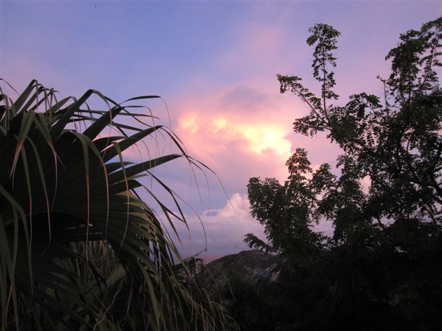
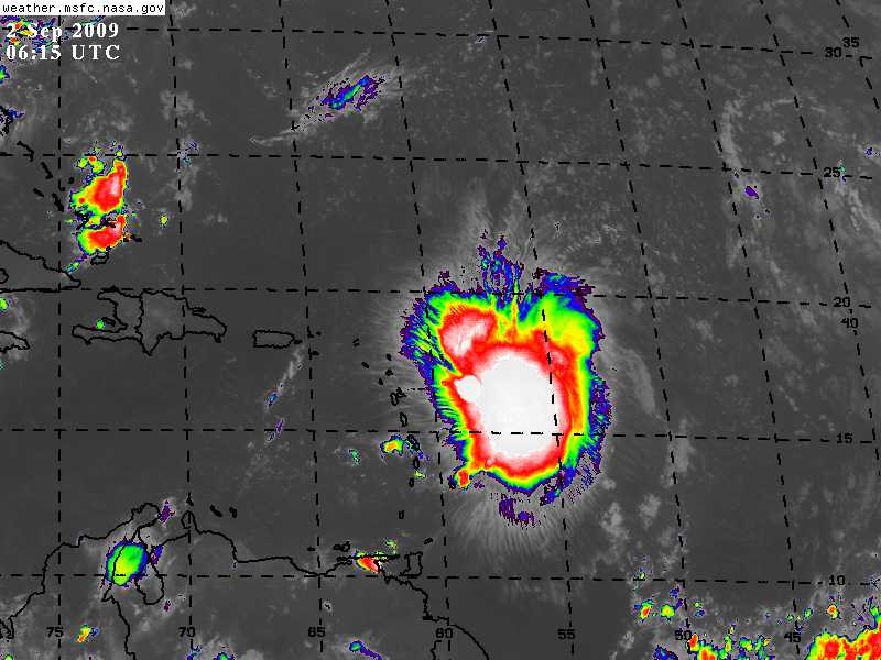
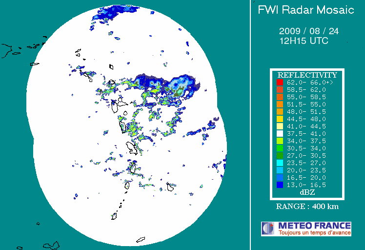
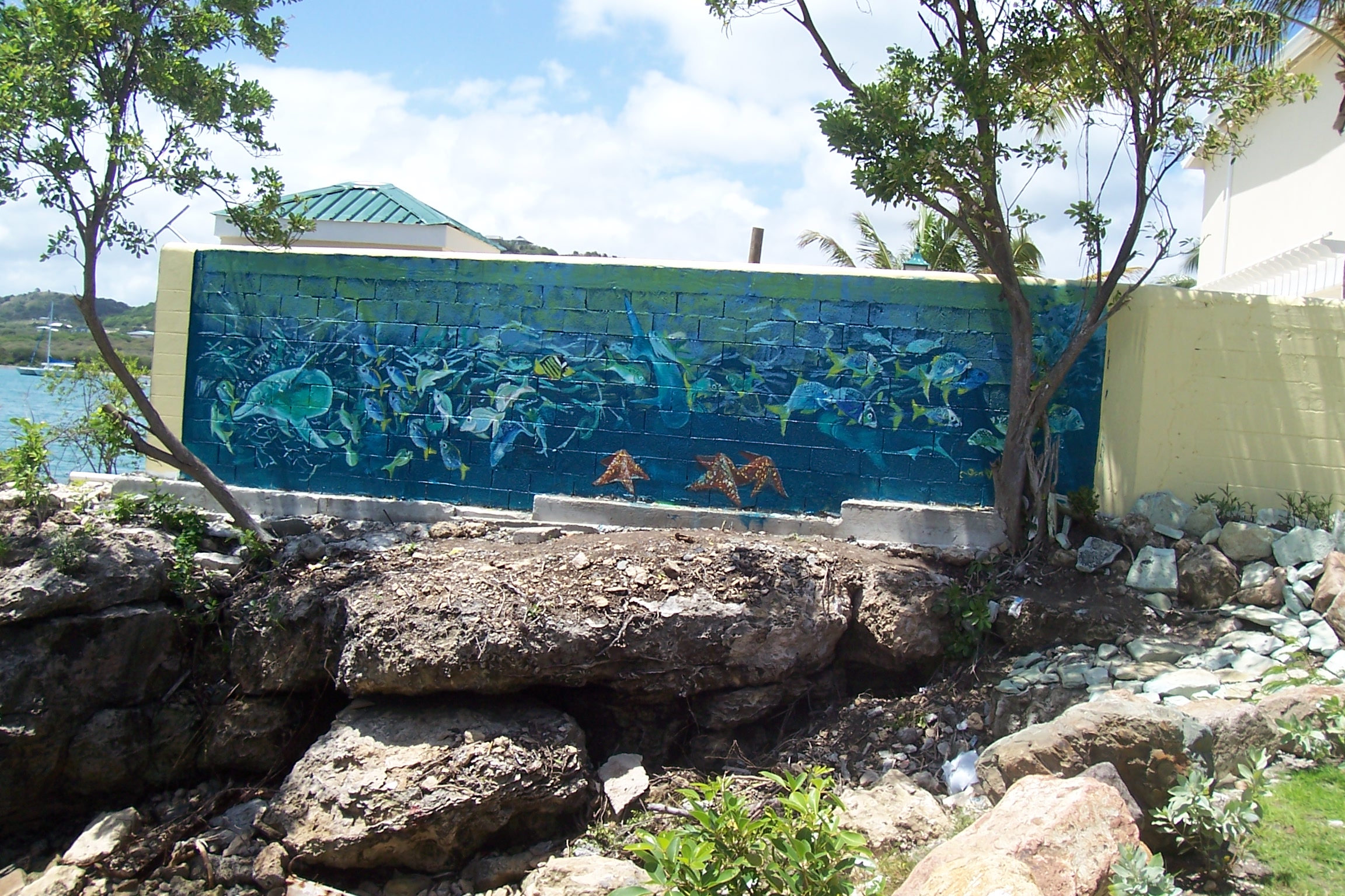
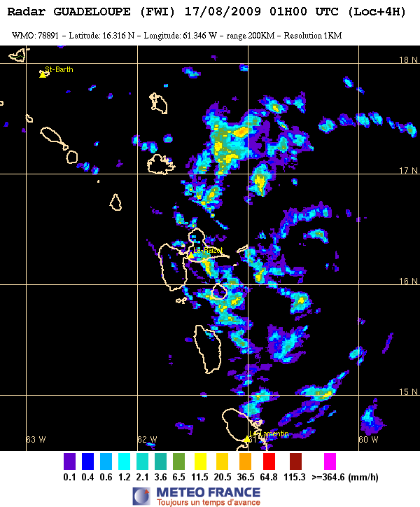
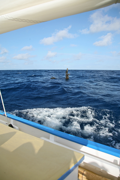
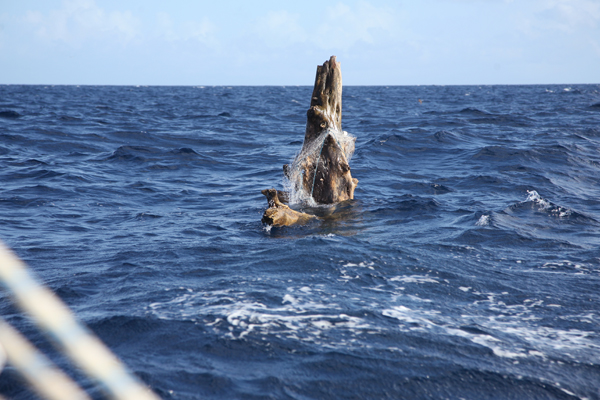
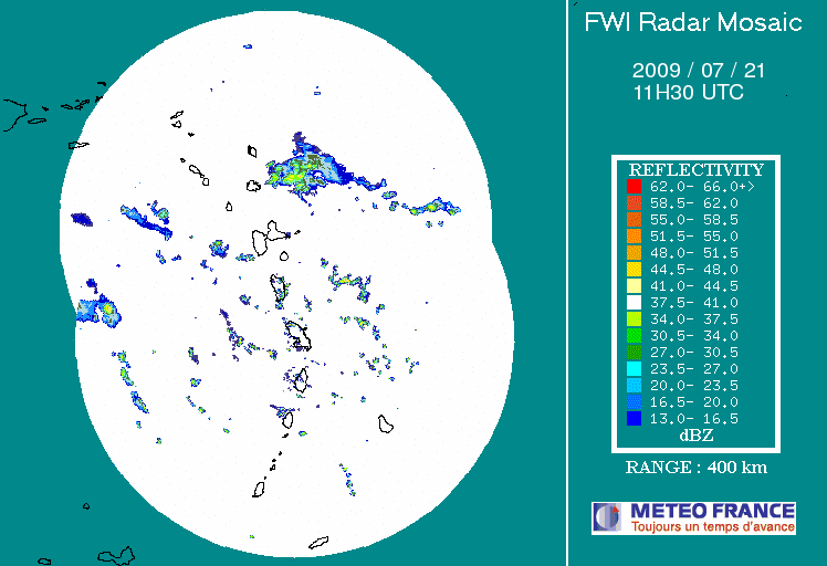
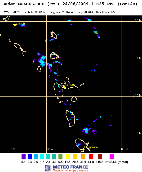
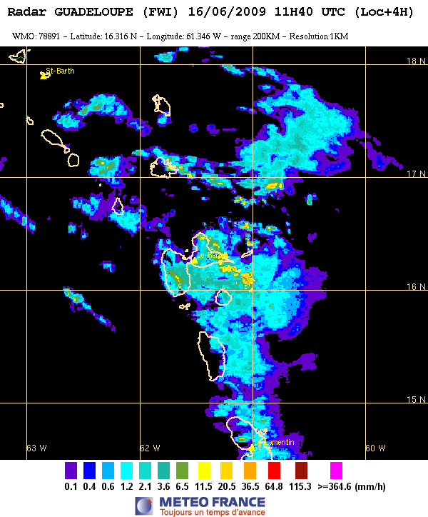