
|
For the most recent reports from the TCI see this page.
- - - 2008 Hurricane Season - - -
|
- Update
|
- From: Rachel Ramdin <rachel_ramdin at hotmail.com>
- Date: Sun, 7 Sep 2008 10:44:44 +0000
|
Just had a text from Grace Bay area. Things didn't seem too bad overnight but they have not looked outside yet.
|
|
|
- [Fwd: Turtle Tail]
|
- From: "William P.N. Smith" <w_smith at compusmiths.com>
- Date: Sun, 07 Sep 2008 06:17:33 -0400
|
Forwarded:

I just spoke to my parents on Turtle Tail, Providenciales via cell
phone.... No power or internet but EXTREMELY high winds as the eye is at
it's closest point to their coordinates which is approximately 45 Miles
away.  The whole house is shaking but so far so good.

-Ania Morton
|
|
- That was quick - Internet back
|
- From: "William P.N. Smith" <w_smith at compusmiths.com>
- Date: Sun, 07 Sep 2008 05:29:42 -0400
|
Internet is back, C&W phones still getting intercept.
|
|
- Phones and Internet down
|
- From: "William P.N. Smith" <w_smith at compusmiths.com>
- Date: Sun, 07 Sep 2008 05:23:34 -0400
|
The Internet (DSL) to Pine Cay just went down, and C&W phones and
cellphones get an intercept. DigiCel phones are still answering.
|
|
- 4:15AM Updates
|
- From: jeff at express.tc
- Date: Sun, 7 Sep 2008 04:15:45 -0400
|
Just heard from South Dock. "Just woke up. Feeling these strong winds but am still doing fine so far."
Update from WIV4 chatroom from "chand" in Richmond Hill: "Lights are out. Very gusty."
Looking at the satellite (with my inexperienced and tired eyes), the eye of the storm should soon be approaching just south of Provo.
-Jeff
Msg sent via Express - HSI Webmail http://webmail.express.tc
|
|
- 3AM Update
|
- From: "William P.N. Smith" <w_smith at compusmiths.com>
- Date: Sun, 07 Sep 2008 03:29:53 -0400
|
The Power and Internet stayed up (at least intermittently) overnight on
Pine Cay, so we got the following reports from my automated weather station:
Weather for yesterday (as of 1:20AM):

        Max Temperature:  86 Degrees F
        Min Temperature:  75

        Max Humidity:     85 Percent
        Min Humidity:     63

        Max Barometer:    29.88 Inches of Mercury
        Min Barometer:    29.48

        Max Solar Power: 1167 Watts per Square Meter

        Peak Windspeed:   48 Miles Per Hour

        Rainfall :        0.17 Inches

Weather for today (as of 3:30AM)
        Peak Windspeed 70MPH
        Rainfall 0.6"

More New As It Happens!
|
|
- Power off at most locations
|
- From: jeff at express.tc
- Date: Sun, 7 Sep 2008 02:43:39 -0400
|
In the last 15 minutes load has dropped from 10% to 1.5%.
I now estimate that power is off to 95% of the homes on Provo. The homes that still have power may well be on personal generators or even small UPS units.
-Jeff
Msg sent via Express - HSI Webmail http://webmail.express.tc
|
|
- 2:15AM Grace Bay
|
- From: jeff at express.tc
- Date: Sun, 7 Sep 2008 02:15:40 -0400
|
Just received this from the Pinnacle in Grace Bay:
"It sounds and looks gustier now but still nothing major. I don't even hear the wind 'howling' like it often does"
-Jeff
Msg sent via Express - HSI Webmail http://webmail.express.tc
|
|
- 2AM Power estimate
|
- From: jeff at express.tc
- Date: Sun, 7 Sep 2008 02:13:48 -0400
|
Traffic is now down to about 10% of total available bandwidth. A fall off at this time of night is normal but I would say this amount is more indicative of most of the island being off the power grid at this point, as well as some people getting some sleep.
The real story will be what the load is come sunrise. If the load comes back, it will be great news. If the load stays down around 10% or less then we've had significant power outages across the island. I will report back after I get some rest.
Some comments in the WIV4 chat room indicate some known roof losses on Grand Turk and the possibility of a fire at the CW facility on Grand Turk (unconfirmed).
-Jeff
Msg sent via Express - HSI Webmail http://webmail.express.tc
|
|
- Ike
|
- From: E Howell <howelledgar at yahoo.co.uk>
- Date: Sun, 7 Sep 2008 05:09:44 +0000 (GMT)
|
Conditions are going down hill fast on Providenciales. I will report when and if it becomes possible.
|
|
|
- 1AM update from Pinnacle
|
- From: jeff at express.tc
- Date: Sun, 7 Sep 2008 01:03:36 -0400
|
1AM at the Pinnacle on Grace Bay:
"Just woke up. Pls still relatively calm. Raining sporadically. Bit gusty"
Well if they can sleep I think I'll try and grab some before the 2am update.
-Jeff
Msg sent via Express - HSI Webmail http://webmail.express.tc
|
|
- Update 6
|
- From: E Howell <howelledgar at yahoo.co.uk>
- Date: Sun, 7 Sep 2008 04:53:04 +0000 (GMT)
|
Reports out of Grand Turk: I believe the morning light will reveal more than we can bear. This is not to alarm anyone only to give a sense of what is really going on. Many homes on Grand Turk have lost roofs and some houses are reported to have collapsed.
The situation is reportedly the same for South Caicos. God help us all!
North Caicos has been without electricity for the last two hours and residents are presently experiencing strong winds and rain. The winds are not yet up to hurricane force.
Providenciales has sustained tropical force winds and intermittent rain. We really cannot say how much longer we will have electricity.
|
|
|
- 12:10AM Update from Turtle Cove
|
- From: jeff at express.tc
- Date: Sun, 7 Sep 2008 00:15:20 -0400
|
A nice update from the Turtle Cove area:
"We're at Turtle cove Marina, where the wind is gusty at approx 35 - 45
mph, no rain to talk about yet but there is a light rain in the air,
it's hot and sticky, and the wind is getting steadily stronger,
especially over the last hour.
Understand from the latest update that the storm is predicted to pass
to the South and Provo will only get the Tropical storm winds, the peak
at around 05:30.
We still have all power and cable and obviously internet access.
fingers crossed..............."
-Jeff
Msg sent via Express - HSI Webmail http://webmail.express.tc
|
|
- Power update at midnight
|
- From: jeff at express.tc
- Date: Sun, 7 Sep 2008 00:05:07 -0400
|
Using our aggregate (Provo only) Internet traffic level as a base, traffic has now decreased from 40% to 34% of normal load, which is likely indicative of more homes losing power. During normal use, traffic tends to fall off rapidly from 2AM but is normally going strong at midnight on a weekend.
I am still accessing my systems and monitoring things from here (Miami), so our office and our aerial fibre optic link are still in tact. We have our own generator so I can't comment on whether we are on PPC power or generator.
-Jeff
Msg sent via Express - HSI Webmail http://webmail.express.tc
|
|
- 11:05PM - Grace Bay
|
- From: jeff at express.tc
- Date: Sat, 6 Sep 2008 23:18:25 -0400
|
This just in at 11:05 PM from Regent on Grace Bay -
(I have been emailing NHC advisorys to my contacts)
"The advisory doesn't really tally to what the weather
is like outside - will give it awhile to see if it changes. I can see the
sea and it just about covers the beach infront of the regent. But jon
has just come in from outside still not raining and he can walk outside
still."
Our systems are showing Internet traffic load at approximately 40%, down from 57% at last update. This is likely indicative of further power outages in specific areas, however, a number of homes still appear to have power.
-Jeff
Msg sent via Express - HSI Webmail http://webmail.express.tc
|
|
- Update 5
|
- From: E Howell <howelledgar at yahoo.co.uk>
- Date: Sun, 7 Sep 2008 03:19:09 +0000 (GMT)
|
Grand Turk is reporting destruction of the roofs of a few homes and sustained strong hurricane force winds. Rain is now falling on Grand Turk. South Caicos is reporting sustained hurricane force winds in excess of 120 mph. The reporters on both islands believe that they are in the brunt 'full force' of IKE.
The reporters also mentioned the horrible sound of the 'screaming' winds. Providenciales, North and Middle Caicos will be a little more north of the eye of Ike than Grand Turk and South Caicos. We can only hope that our experience latter tonight is a little less horrifying.
Conditions at Providenciales are not as bad as one might have expected it to be at this time. The stuff is on it way though. Conditions on Middle and North Caicos will be deteriorating within the hour. North Caicos is expected to report soon and
electricity permitting I will share the report with you.
|
|
|
- Update 4
|
- From: E Howell <howelledgar at yahoo.co.uk>
- Date: Sun, 7 Sep 2008 02:37:33 +0000 (GMT)
|
Providenciales is currently experiencing tropical storm force winds. As indicated from reports coming out of Grand Turk, this appears to be a dry but windy hurricane. I might not be able to get much out after this if mandatory power outages take effect. It was reported that Five Cays on Providenciales is already without electricity - this has not been confirmed.
I regret that I am unable to give specific data at this time.
|
|
|
- Power now off at Regent
|
- From: jeff at express.tc
- Date: Sat, 6 Sep 2008 22:25:06 -0400
|
10:15PM - "Regent have shut off there power we are not on the generator"
-Jeff
Msg sent via Express - HSI Webmail http://webmail.express.tc
|
|
- 10PM Update - Grace Bay - Regent Grand
|
- From: jeff at express.tc
- Date: Sat, 6 Sep 2008 22:23:37 -0400
|
This just in (10PM) from a colleague hunkered down at the Regent Grand in Grace Bay:
"Still the same outside no rain yet either. Just getting ready for power to go out."
PPC had earlier announced that the power would be shut down at a certain wind speed (which I don't have), but the expectation was around 11PM. Cable and Wireless Blackberry service is still functioning.
My monitoring systems indicate Internet traffic load around 57% of normal for this time of day (Express High Speed Internet). Given the number of people who have left the island, I would say most people who are still there have power and are online.
The primary international telecoms capacity for the country is via the ARCOS (www.nwncable.com) submarine cable system, which lands at Northwest Point on Provo. I beleive C&W connects to that point via aerial fibre cable, which could be subject to damage by the winds and flying debris. However, C&W also had/have a wireless microwave system that should allow them to restore emergency capacity, once the storm passes, between their main office on Leeward Highway and the submarine cable station.
As the submarine cable itself is unlikely to be damaged by the storm, restoration should (hopefully) be fairly rapid once the storm passes. The cable station itself contains daul backup generators and air conditioning units. It is located on very high ground overlooking the Aman resort.
In addition, both C&W and I believe Digicel have some modest level of satellite uplink capability to get some voice traffic out of the country. So my optimistic forecast would be that within 48 hours or less, if it isinterupted at all, international traffic should be flowing again after Ike departs. However, localized damage to the physical wiring in the air, as well as potential damage to cell phone towers, may mean calling is sporadic for some time. Please be patient as you try and get calls through and please keep your calls brief so that others can get through to their loved ones as well.
High speed Internet access, as it is delivered by physical cable (whether DSL or cable modem) will likely be slower to recover and recover on a case by case and "leg by leg" basis as the physical path from the home to the provider needs to be completley restored.
-Jeff
Msg sent via Express - HSI Webmail http://webmail.express.tc
|
|
- Thanks to AA and Airport Staff
|
- From: jeff at express.tc
- Date: Sat, 6 Sep 2008 21:53:55 -0400
|
While we await another update from the island I'm going to take a moment and thank American Airlines (and all the other airlines and private operators) and the staff at the Provo Airport on behalf of all the tourists and residents of Provo.
I was at the airport Thursday to get a ticket issued for my infant daughter and despite the high level of stress and nervousness, and the loss of air conditioning, the long lines and short patience; the staff at AA were great. Starting with the local desk and ground crew all the way through the flight crews and pilots, everyone was excellent at getting people checked in, through security and on to the planes. I do have to say some of the passengers were not so gracious.
Yes, some of the planes went out with empty seats, which is a shame, but by and large they were quite full and handled very professionally and everyone involved deserves a big thank you. AA put on a number of extra flights and worked very hard to make the evacuation as smooth and widely available as possible. We must never forget these people have families and homes to worry about too and they were there, doing their jobs, so others could leave the path of the storm.
Again, thank you to all involved.
-Jeff
Msg sent via Express - HSI Webmail http://webmail.express.tc
|
|
- Update
|
- From: E Howell <howelledgar at yahoo.co.uk>
- Date: Sun, 7 Sep 2008 01:52:29 +0000 (GMT)
|
Grand Turk and South Caicos are reporting winds at or in excess of 100 mph. Electricity is totally gone on Grand Turk and rumblings can be heard on the outside. Hopefully it is not someone's roof. Providenciales - Blue Hills reported a heavy downpour recently with strong wind gusts.
Providenciales will probably have mandatory power outages in the next 45 to 60 minutes. We will soon see. The skies are totally overcast now and rain is spreading across the island.
|
|
|
- Re: TCI Update (fwd)
|
- From: Gert van Dijken <gert at vandijken.com>
- Date: Sat, 6 Sep 2008 21:32:23 -0400 (EDT)
|
---------- Forwarded message ----------
Date: Sat, 6 Sep 2008 21:02:01 -0400
From: jeff at express.tc
Subject: Re: TCI Update

  BODY { font-family:Arial, Helvetica, sans-serif;font-size:12px; }A
few more updates from Provo from moments ago:
 From someone at the Pinnacle on Grace Bay:
 "Still nothing much here except rough seas and a bit of wind. Stood
on the 3rd floor balcony of the pinnacle a moment ago. The air was
warm but blowing. Will get rougher in an hour or so. "
 From someone at the Regent Grand, also on Grace Bay:
 "Ok just in from walking the dog. Its windy...very warm wind but no
rain yet and its like a winters day at home (Ireland) minus the rain
and about 30degress warmer! Will take another walk in an hour or so to
see what its like"
 I advised against a further walk.
 -Jeff
  PS - Internet traffic is still at about 50% of normal load for this
time of day, so a lot of people still have High Speed Interent (via
cable TV), although some people recently dropped offline so there may
be localized cable or power outages starting.
|
|
- TCI Update
|
- From: jeff at express.tc
- Date: Sat, 6 Sep 2008 20:47:16 -0400
|
I am one of the many evacuees from Provo based in Miami to ride out the storm. I am keeping in regular phone and email contact with friends and team members still on Provo. As well I'm monitoring the satellite and news headlines for any relevant info.
One good bit of news appeared in an AP wire story a few hours ago, confirming that the British hurricane ships were on standby to support us in the TCI. From the article here: http://ap.google.com/article/ALeqM5iLUWqLQhRD0-04G4mdGIPLiG1ZiwD931CG980
"A spokesman for Britain's Ministry of Defense said the HMS Iron Duke, a
frigate, and the HMS Wave Ruler, an auxiliary ship, were on standby in
the Turks and Caicos with food, water, medical supplies and some
shelter-building equipment, as well as a helicopter. He spoke on
condition of anonymity in line with military policy."
A report moments ago from a resident in Discovery Bay was that winds were approximately 25 knots, and cable TV and High Speed Internet were still working.
Reports from the Grace Bay area were that winds were also picking up, but no speed estimates were given.
Word from a volunteer at the shelter near Maranatha High was that the shelters were already at capacity from earlier in the day, which is a big concern considering the storm hasn't even arrived yet.
-Jeff
Msg sent via Express - HSI Webmail http://webmail.express.tc
|
|
- Update 2
|
- From: E Howell <howelledgar at yahoo.co.uk>
- Date: Sun, 7 Sep 2008 00:42:09 +0000 (GMT)
|
Providenciales is still relatively calm but I suspect things are headed down hill and will go very fast.
Grand Turk is reporting power outage in certain sections of the island. South Caicos is reporting winds in excess of 50 mph and electricity is now gone.
Current conditions at Providenciales: the moon and a few stars are still visible through high cirrus clouds in the western half of the sky. The winds are out of the north at 18 mph with higher gusts. I cannot confirm barometric pressure at this time.
We are in the saddle and holding on to the reins, AGAIN! We'll see and know how well we've done tomorrow.
|
|
|
- Update
|
- From: E Howell <howelledgar at yahoo.co.uk>
- Date: Sat, 6 Sep 2008 23:20:51 +0000 (GMT)
|
The sun bade the residents of Providenciales farewell for another eventful night.
Grand Turk is reporting dark overcast skies. It rained there about an hour ago but only for 15 minutes or so. The wind is increasing in strength and there is a 'feeling' in the air that something is different about this one.
Current conditions at Providenciales: partly cloudy skies with winds out of the NNW at 18 mph; temperature is 80 F. In a squall that just passed through we recorded 2 mm of rain; the seas are choppy.
|
|
|
- IKE - Turtle Cove Providenciales Turks and Caicos
|
- From: "Rowland" <rowland.hull at btinternet.com>
- Date: Sat, 6 Sep 2008 19:00:26 -0400
|
18.52
Skies darkening, wind starting but we are tucked up and
still have electricity. DM teams working hard. Expect to be out early tomorrow
to assist. Premier just been on BBC World, THANK YOU BBC - but spare a
thought for poor Haiti. So far we are ok in Provo in Turtle Cove, but not
so lucky in the lower areas where we are expecting massive flooding.
Much energy here in boarding up and people working together
to face the brute. Looks like we may get a little relief as it looks like it is
going south a bit but other islands not so lucky at this point.
At the mo TCove has elec, internet and about to eat. Lucky
me. We shall see. Had a couple of very nice emails from some readers.. thanks. It’s
a bit busy this year.
RH
|
|
|
- Quick update
|
- From: "William P.N. Smith" <w_smith at compusmiths.com>
- Date: Sat, 06 Sep 2008 18:53:33 -0400
|
Ike is starting to build strength in the TCI, peak wind speeds have
already hit 40MPH. With a forecast wind speed of 145MPH and predicted
storm surge of 13-18 feet, this could be really bad news.
The Internet and Power have been up and down all day, but when they are
up you can see current conditions on Pine Cay at
http://www.wunderground.com/cgi-bin/findweather/getForecast?query=pic
Our hopes and prayers go out to everyone in the TCI, here's hoping we
hear good news on Sunday!
|
|
- Hurricane Ike
|
- From: Norma Jackson <ejacksonnorma at hotmail.com>
- Date: Sat, 6 Sep 2008 20:28:02 +0000
|
Hurricane Ike is fast on its way towards us. Tropical storm force winds are predicted to hit Grand Turk at about 6:00 p.m. and Provo at 9:00 p.m. All residents needing to go to higher ground and shelters in Provo have been asked to be there by 6:00 p.m. and Grand Turk residents should already be in safe places. The storm surges are predicted to be l0 to l2 feet and the places within 8 miles of the sea could be in dangerous situations. The stores are closed now. There is nothing we can do now but try and stay safe. At least it should be a fast moving storm, that is one good thing. Please pray for all of the people in these small islands. Hopefully by this time tomorrow Ike will be just a bad memory for us.
Explore the seven wonders of the world Learn more!
|
|
|
- Ike -yikes!
|
- From: E Howell <howelledgar at yahoo.co.uk>
- Date: Sat, 6 Sep 2008 14:12:30 +0000 (GMT)
|
It appears Ike has developed a serious interest in the Turks and Caicos Islands and he is on course for a 'close-up and personal' encounter later today and into tomorrow. The centre is expected to pass over several islands in the Caicos group. This could spell disaster if the surface winds are as strong as is estimated. I suppose one good thing about this system is that it is moving at a fast clip - 16 mph. Whether Ike's eye passes slightly north of us or directly over us is all in the hands of the almighty.
The final preparations are made or, in a few cases, are being made. Residents living in low lying areas especially near the ocean have made arrangements to move to higher ground. The power company on Providenciales has advised that electricity will be turned off once a predetermined wind speed is reached. This is probably the case for the other companies throughout the islands. I suspect weather conditions will begin to worsen after 5 pm today, from there on out, God Speed!
Current conditions at Providenciales: winds at 5 mph from the northwest, clear skies with cirrus clouds on the horizon. Grand Turk is reporting overcast skies.
|
|
|
- Turtle Cove Providenciales
|
- From: "Rowland" <rowland.hull at btinternet.com>
- Date: Fri, 5 Sep 2008 23:14:40 -0400
|
Turtle Cove
Beautiful day today. The calm before the storm. Hurricane
Warning in effect. Beautiful sunset last night. Hot and steamy. Roads very
busy, many buildings now boarded up and DM teams in place. WIV (tv) doing a
great job live information as I type. Several friends have left for Miami, many
extra flights laid on. Boats in marina thinning out as they are stored
elsewhere. Heavy equipment parked on high ground. Cable and Wireless and
Digicel drop rates on all local calls reduced to 15 c per min for all
customers. Hope the system can cope with the extra traffic. Temperature and expectation
increasing as is concern over high storm surge. Residents in low lying areas
encourage to move to friends and family on higher ground. Public shelters will
be open as of midday to accept evacuees. My windows being boarded up in the
morning, hope the crew turn up. Lot of calls for community to respond positively
and be vigilant and supportive of all services. RH
|
|
|
- Out of the Frying Pan...
|
- From: E Howell <howelledgar at yahoo.co.uk>
- Date: Fri, 5 Sep 2008 23:22:58 +0000 (GMT)
|
At 2pm today the government of the Bahamas issued a hurricane watch for the Turks and Caicos Islands. Residents throughout the country have been making preparations for the approaching category 3 hurricane. A mandatory evacuation of Salt Cay has been put into effect and several international flights have transported a number of people to distant lands - hopefully lands not in the eventual path of Ike.
Residents, on each inhabited island in the chain, have take the necessary steps to secure life and property. Storm shutters are in place and people are stocking up on can goods and other vital supplies. The clinics made special arrangements for persons needing to refill their medication. The authorities at the Department for Disaster Management have stepped up their plans and we are about to face the music for the second time.
Ike is expected to pack a solid punch in a short period of time and move on to other vistas. The trouble with this scenario is that the ground is saturated, trees are blasted and I believe things are at a tipping point. The centre of Ike is expected to pass just north of the Turks and Caicos Islands - just off North Caicos - the northernmost island in the chain. This would mean that our sustained winds will again, as with Hanna, come at us from the north, northwest, west, southwest, south and then the southeast. We can potentially see another, but much more dangerous, storm surge. Let us prepare with this in mind and make every haste to complete all preparations before noon tomorrow.
The day had an uncanny beauty to it. Clear blue skies; the ocean was as smooth as glass and the varied colours of the sea were in their ultimate glory.
Current conditions at Providenciales: winds out of the northeast at 3 mph.
Edgar V. Howell
"You have to decide what your highest priorities are and have
the courage -- pleasantly, smilingly, non-apologetically --
to say 'no' to other things. And the way you do that is by
having a bigger 'yes' burning inside."
- Stephen R. Covey
|
|
|
- Advisory #2-Hurricane Ike (fwd)
|
- From: Gert van Dijken <gert at vandijken.com>
- Date: Fri, 5 Sep 2008 18:55:57 -0400 (EDT)
|
---------- Forwarded message ----------
Date: 5 Sep 2008 22:32:43 -0000
Subject: Advisory #2-Hurricane Ike

      Message:? Hurricane Ike heads toward the Bahamas (As at 5.00p.m.
September 5, 2008)
     The Situation:
     A Hurricane Watch is effect for the Turks and Caicos islands and the
Southeastern Bahamas.
     At 5.00 p.m? today, September 5, 2008 the centre of Hurricane Ike was
located near latitude 22.9 North and longitude 64.1 West or about 430 miles
(690 km) northeast of the Leeward Islands and about 460 miles (735 km)
east-northeast of Grand Turk Island.
     Ike is moving toward the west-southwest near 15 mph (24 km/hr) . A motion
toward the west or west-southwest is expected tonight and tomorrow with a
general motion to the west expected by Sunday. On this track Ike could be near
the Turks and Caicos Islands and the southeastern Bahamas early Sunday.
     Hurricane Ike is a category three hurricane on the Saffir-Simpson scale
with maximum sustained winds near 115 mph (185 km/hr) with higher gusts.
Hurricane Hurricane force winds extend outward up to 45 miles (75 km) from? the
center and tropical storm force winds extend outward up to 120? miles (195 km).
     Hurricane Ike is expected to be a major hurricane as it nears the
hurricane watch area.
     National Actions:
     Even as damage assessments and recovery efforts are being carried out in
the? Bahamas and the Turks and Caicos Islands in the wake of Hurricane Hanna,
monitoring and preparing for Hurricane Ike is now priority.
     The National Emergency Management Agency in the Bahamas has reported that
urgent preparations are being advanced for a probable impact from? Ike.
     Reports from the Turks and Caicos Islands Department of Disasters and
Emergencies Office have indicated that extensive planning is underway for Ike
and this is being supported by a UK Support Team.? Tourists are being
transferred off the Islands and Salt Cay is being evacuated. Arrangements are
being made to obtain emergency food from Miami.
     Regional Response:
     The Caribbean Institute of Meteorology and Hydrology continues to brief
CDERA on the progress of Ike and to provide analysis on its development and
probable effect on the islands.
     CDERA has developed scenarios to assist its response planning operations
and has shared these with the threatened states, Jamaica sub-regional focal
points and other critical members of the Regional Response Mechanism.
     Radio and other communications checks with the Bahamas and Turks and
Caicos Islands are being carried out by CDERA.
     CDERA is in the process of coordinating arrangements to have in place a
damage assessment team on standy for deployment to TCI in the event that they
are affected by Hurricane Ike.
     The Regional Response Mechanism is also on standby.
     Contact Details: The CDERA CU 24hr contact number is 1 246 425 0386
|
|
- South Caicos
|
- From: Norma Jackson <ejacksonnorma at hotmail.com>
- Date: Fri, 5 Sep 2008 01:12:08 +0000
|
I just watched local news footage of the damage Hanna caused in South Caicos. There is major flooding. It was reported that island was the worst hit by hurricane Hanna. The airport is closed as the runway is covered with water. A lot of homes are sitting in water. The water is receding but a lot of the main highway is still under water. It is a very difficult time for the residents of that island. We have to continue to pray that we are spared the ravages of Ike and that it turns north before it affects any islands.
Connect to the next generation of MSN Messenger Get it now!
|
|
|
- Situation Report #3 -Tropical Storm Hanna (fwd)
|
- From: Gert van Dijken <gert at vandijken.com>
- Date: Thu, 4 Sep 2008 17:54:53 -0400 (EDT)
|
---------- Forwarded message ----------
Date: 4 Sep 2008 21:53:07 -0000
Subject: Situation Report #3 -Tropical Storm Hanna

      Message: Hanna moves away from the Bahamas (As of 2.00 p.m. September 4,
2008)
     Event:?
     As of 2.00 pm September 4, 2008 a Tropical Storm Warning remains in effect
for the central and northwestern Bahamas.
     The centre of Tropical Storm Hanna was located near latitude 25.1 north
and longitude 74.2 west or about 205 miles (330 km) east of Nassau.
     Maximum sustained winds are near 65 mph (100 km/hr) with higher gusts.
Hanna is a large tropical cyclone with Tropical Storm force winds extending
outward up to 215miles (510 km) mainly to the north of the centre.
     Prognosis:
     Hanna is moving towards northwest near 14 mph (22km/hr) and this motion is
expected to continue during the next day or so with a gradual increase in
forward speed. However, on this track the centre of Hanna will pass just east
of the central and northwestern Bahamas later today.
     Turks and Caicos Islands (TCI)
     Hanna exited the Turks and Caicos Islands last night. Operations and
policy meetings were held today at 10.00a.m and 12.00p.m respectively.
     All airports are now open and a number of flights are planned for today
and tomorrow to take tourists who were stranded during the passage of Hurricane
Hanna off the islands.
     PAHO has dispatched a water and sanitation engineer who will arrive
tomorrow September 5, 2008 to provide technical assistance.
     Bahamas
     Central and Northeastern Bahamas remain on Tropical Storm Warning. Heavy
swells and high winds were reported in San Salvador as Hanna passed
approximately 76 miles to the East.
     Regional Response:
     The Regional Response Mechanism (RRM) remains on standby as the threat of
Hurricane Ike, a category four Hurricane on the Saffir-simpson Scale approaches.
     CDERA will continue to monitor the situation and provide advisories as
necessary.
     Contact Details: The CDERA CU 24hr contact number is 246 425 0386
|
|
- Donate to storm carib
|
- From: Norma Jackson <ejacksonnorma at hotmail.com>
- Date: Thu, 4 Sep 2008 12:26:53 +0000
|
This website is the best source of information for us as storms approach. Please support it with donations if you can afford it. Now that Hanna is now history for us in the Turks and Caicos Islands we now will use this site constantly to monitor the approach of Ike. I constantly use the closest point of approach feature, thank you Gert for your hard work. I often get very irritated with the weather channel as it tends to forget us, and go on to discussions about when the states will be hit.
Explore the seven wonders of the world Learn more!
|
|
|
- Ike
|
- From: Norma Jackson <ejacksonnorma at hotmail.com>
- Date: Thu, 4 Sep 2008 12:21:35 +0000
|
The sun is shining brightly over Provo at the moment, what a beautiful sight. We are all preparing for the oncoming Ike's unwanted visit. Please pray for us that the storm moves further north so we don't receive a direct hit from the category 4 monster. We just took a drive to Five Cays and the water is receding from the roads. We were at the IGA when it opened at 7:00 a.m. and there were already quite a few people there A sign posted states that the boat is in but the dock is closed, hopefully it will reopen today. The shelter at the Enid Capron school in Five Cays has an urgent request for diapers and any other supplies people can contribute. Please help if you can. We all have to work together as we are all on this little island together and must face this storm. Many thanks to the police and firemen who are working 24 hours to rescue and protect our citizens.
Get news, entertainment and everything you care about at Live.com. Check it out!
|
|
|
- Hirricane Ike.
|
- From: "Rowland" <rowland.hull at btinternet.com>
- Date: Thu, 4 Sep 2008 07:49:48 -0400
|
Turtle Cove : Providenciales
07.46 am Turtle Cove
Beautiful morning. Ike now a formal Cat 4 and DM systems
kicking in. Dm advised by text contractors to make building sites safe. Thanks
WIV (TV station) for the images and info – going out in three languages.
Radio TCR hangs in with info but was asking for more information. We still have
power and cable.
Rh
|
|
|
- Hurricane Ike
|
- From: "Rowland" <rowland.hull at btinternet.com>
- Date: Thu, 4 Sep 2008 00:59:26 -0400
|
Turtle Cove. Providenciales 00.57 hrs
Cable and Wireless customer care text message received. “Disaster Management
advises that TCI remains under a Hurricane Warning and could feel the effects
of Hurricane Ike, currently a category 4 hurricane within 48 hours” Sept
4 00.07.32
Second message received from same source “Disaster Management
urges residents of the TCI to take necessary precautions to prepare for
Hurricane Ike. Secure property and have enough food and water supplies.”
Sept 04 00.48.42 received.
All calm in Turtle Cove.
RH
|
|
|
- Provo Airport
|
- From: Norma Jackson <ejacksonnorma at hotmail.com>
- Date: Thu, 4 Sep 2008 00:42:41 +0000
|
I have been advised by the airport manager that the airport is scheduled to reopen at 6:00 a.m. American Airlines is planning 5 or 6 flights to accommodate passengers. Hanna appears to have dissipated, on its way to strike the Bahamas as a category l hurricane. Ike is a real threat, we just have to hope that it swings north a bit more, otherwise this island will be in major trouble.
Invite your mail contacts to join your friends list with Windows Live Spaces. It's easy! Try it!
|
|
|
- Situation Report #2 -Tropical Storm Hanna (fwd)
|
- From: Gert van Dijken <gert at vandijken.com>
- Date: Wed, 3 Sep 2008 19:12:53 -0400 (EDT)
|
---------- Forwarded message ----------
Date: 3 Sep 2008 22:49:56 -0000
Subject: Situation Report #2 -Tropical Storm Hanna

      Message: Hanna beginning to move north-northwestward (As of 2.00 p.m,
September 3, 2008)
     Event: ?
     As of 2.00pm September 3, 2008 a Hurricane Warning remains in effect for
the central Bahamas, southeastern Bahamas and the Turks and Caicos islands. A
hurricane watch is in effect for the northwestern Bahamas.? The centre of
Tropical Storm Hanna was located near latitude 21.4 north and longitude 72.0
west or just south of the Turks and Caicos.

     Maximum sustained winds are near 60 mph (95 km/hr) with higher gusts.
Hanna is a large tropical cyclone with Tropical Storm force winds extending
outward up to 290miles (465km) mainly to the north of the centre.

     Rains and strong winds continue to affect the Turks and Caicos Islands and
the southeastern Bahamas.

     Prognosis:
     Hanna is moving towards north-northwest near 10mph. A turn to the
northwest with an increase in forward speed is expected over the next 24 hours.
However, the On this track the centre of Hanna should be moving through or just
east of the central and northwestern Bahamas over the next 48 hours. Hanna is
expected to produce 4 to 8 inches of rain with isolated amounts of up to 12
inches over the southeastern Bahamas and the Turks and Caicos islands. Storm
surge of 1 to 3 feet above normal tide levels can be expected in areas of
onshore flows within the hurricane warning areas.

     TURKS AND CAICOS ISLANDS (TCI)
     Impact
     Tropical Storm Hanna continues to affect the islands in the Turks and
Caicos with strong winds and heavy rainfall.?Preliminary assessments were
conducted and flooding has been reported throughout the islands especially in
Five Cays, Providenciales.?
     ?
     All schools, government offices, business community and private sector
establishments remain closed.

     Response:
     The National Emergency Operations Centre (NEOC) which serves as the
     coordinating centre for all the islands of the TCI remains activated.
     Yesterday, September 2, the Governor met with the NEOC of the
     Emergency Policy Group to get an update of the impact and to consider
     critical next steps.
     ?
     The Engineering and Maintenance Services (EMS) began pumping the flood
waters from the land into the sea with the aid of one (1) of their new portable
salt water pumps.?The canal gates are also opened at low tide to allow the
ponds to drain into the sea and subsequently closed at high tide to prevent
seawater from filling the ponds and Salinas.
     ?
     Airports:
     All airports remain closed and non operational due to the adverse weather
conditions which include flooding, debris on runway and damaged fence.

     Casualties:
     No deaths have been reported. All missing persons have been accounted
     for.

     Shelters:
     Shelters remain open, however it was noted that shelter population was
greatest at night. Most shelterees left at first light. Of the shelters
activated Providenciales had approximately 800 shelterees.

     Damage:
     Preliminary damage assessments were conducted and flooding has been
reported throughout the islands especially in Five Cays, Providenciales.?There
was evidence that part of the perimeter fencing at the Providenciales Airport
was destroyed by a three (3) foot storm surge.

     Housing:
     Miinor damage to roofs reported.??

     Utilities:
     Electricity has been restored to most of the islands. Telephone service
remains functional and the internet service continues to be a reliable form of
communication except for a very brief period when there was an apparent loss in
the service.
     ?
     However, the water supply provided by City Water in Grand Turk is still
not operational and the majority of residents are relying on their cisterns.
     ?
     Roads:
     Most roads have suffered damage due to storm surge and flooding.?The
recently constructed Causeway linking North and Middle Caicos has suffered what
appears to be major damage and may even have been destroyed.?

     Boats:
     There were reports of boats washed ashore, damaged or sunken.

     NEEDS IDENTIFIED
     There is a requirement for Environmental Health Department to monitor the
operation of the sewage systems especially in the areas that are experiencing
flooding.??

     A structural engineer will be required to assess the level of damage to
the causeway linking North and Middle Caicos.


[...]


     REGIONAL RESPONSE
     The CDERA Coordinating Unit remains in regular contact with the Bahamas
and the Turks and Caicos to provide support and advice.
     ?
     The Regional Response Mechanism (RRM) remains on standby.
     ?
     CDERA has been collaborating with the Caribbean Institute of Meteorology
and Hydrology for reviewing and analyzing the progress and development of
tropical systems in the Atlantic.? In this regard the CDERA CU is also
monitoring the development two other tropical systems, Tropical Storm Ike and
Josephine.

     As at 11.00a.m. September 3, 2008, the centre of Tropical Storm Ike was
located near latitude 20.8 north and longitude 51.2 west. ?

     As at 11.00a.m. September 3, 2008, the centre of Tropical Storm Josephine
was located near latitude 13.8 north and longitude 28.8 west. ?

     CDERA will continue to monitor the situation and provide advisories as
necessary.
     ?
     Contact Details: The CDERA CU 24hr contact number is _246 425 0386_
|
|
- Hanna and Ike
|
- From: Norma Jackson <ejacksonnorma at hotmail.com>
- Date: Wed, 3 Sep 2008 19:27:31 +0000
|
We will be happy to see the end of Hanna. She took us completely by surprise. A predicted tropical storm of 45 mph turned into a category one hurricane in a few hours. We hope Ike will surprise us and miss us but right now we feel very threatened by it. I hope we have time to get the rest of our windows covered before the next onslaught. This is our third day of rain and the island is saturated.
There is lots of flooding, with some areas, especially Five Cays, almost inaccessible. Power is out in some areas and may be for a few days, until things dry up. Our power has been sporadic, but we have to give lots of credit to the hard working people at PPC who are doing their best fighting the elements. I am sure it is not easy to be working in pouring rain and high winds, trying to get power restored.
The airport is closed until at least Sunday and if Ike makes an appearance will not open then.
The IGA received its shipment so that is good news. We could find one gas station this morning that was open so we were able to fill up.
We heard the causeway between North and Middle Caicos is gone as well as the new marina at Heaving Down Rock. People lost boats as there was no warning to tie them up. Some people lost their roofs and shingles. All we can do is be prepared for Ike, and pray it goes north of us.
Explore the seven wonders of the world Learn more!
|
|
|
- TS Hanna - Update
|
- From: E Howell <howelledgar at yahoo.co.uk>
- Date: Wed, 3 Sep 2008 17:49:19 +0000 (GMT)
|
We continue to keep a close eye on Hanna with her indecision and all. Rain continues to fall on most of the islands in the chain. Grand Turk is currently reporting sunshine. This is visible on the current satellite loop.
According to the official position of Hanna from the National Hurricane Centre, the old lady is still to the south of us and has obviously misplaced her cane. We are probably in for more rain and wind later today if she can get things going around her centre again.
The power companies must be praised for their fast response time and for braving the elements to keep the electrons flowing through the overhead wires. The high cost of electricity has almost become a non-issue - if only for the last four days.
It will take a bit of work to get the country up and running again and I am certain residents are anxious to get this process started. The food stores must have made a fortune these past few days. Flood water is beginning to recede in some areas.
We realise we are not in the clear as yet - Hanna is still south of us and Ike is steering in our general direction. We do look forward to tomorrow and the days ahead.
I don't think I will be complaining about a lack of rain in the Turks and Caicos Islands for a few months yet.
|
|
|
- Situation Report #1 -Tropical Storm Hanna (fwd)
|
- From: Gert van Dijken <gert at vandijken.com>
- Date: Tue, 2 Sep 2008 18:59:46 -0400 (EDT)
|
---------- Forwarded message ----------
Date: 2 Sep 2008 22:03:23 -0000
From: webmaster at cdera.org
Subject: Situation Report  #1 -Tropical Storm Hanna

      Message: Heavy Rains and strong winds continue to affect Turks and Caicos
Island and South Eastern Bahamas (as at 2:00p.m, September 2, 2008)
     Event: ?
     A Hurricane Warning remains in effect for the central Bahamas,
southeastern Bahamas and the Turks and Caicos islands. As at 2.00pm, September
2, 2008, the centre of Tropical Storm Hanna was located near latitude 20.6
north and longitude 72.9 west or just southeast of Great Inagua island in the
southeastern Bahamas and about 420 miles southeast of Nassau.
     Maximum sustained winds are near 70 mph (110 km/hr) with higher gusts.
Tropical storm force winds extend outward up to 175 miles (280km) from the
centre.
     ?Rains and strong winds have been affecting the Turks and Caicos Islands
and the southeastern Bahamas over the last 36 hours.
     Prognosis:
     Hanna is drifting southeastward today however, the forecast indicates that
a northwestward motion is expected to begin tonight or tomorrow.??On this track
Hanna will be moving over the southeastern Bahamas tonight and central Bahamas
tomorrow and produce 4 to 8 inches of rain with isolated amounts of up to 12
inches over the southeastern Bahamas and the Turks and Caicos islands
     ?
     TURKS AND CAICOS ISLANDS (TCI)
     Impact
     Hurricane HANNA has been battering the islands of the TCI with strong
winds, high seas and very heavy rain that at times are accompanied by thunder
and lightning.?As a result there is widespread flooding throughout all the
islands.?These conditions were being felt throughout the day and still
continue.?There are reports of fallen trees and minor damage to
roofs.?Preliminary damage assessment will commence as soon as it is safe to do.
     ?
     Response:
     ?The National Emergency Operations Centre (NEOC) which serves as the
coordinating centre for all the islands of the TCI has been activated and is
being manned by the staff of the Office of Disaster and Emergencies.
     Search and rescue operations are being??
     ?
     Airports:
     All airports were closed at 13.30hrs on Monday, September 1.
     ?
     Casualties:
     No deaths have been reported. Reports of missing persons on
     the island of Providenciales are being investigated by the police.
     ?
     Shelters:
     Many persons have left their homes in low lying areas and are seeking
shelter with family and friends on higher ground. Some churches are also
accommodating persons in need of shelter. Of the shelters activated, 12 persons
are in shelters on Grand Turk, and 225 on Providenciales. The shelter at the
Community Centre on Middle Caicos had to be closed due to the ingress of water
and the shlter at Mt. Oliver Baptist church was activated instead.
     ?
     Damage:
     EOC Providenciales:
     The building has suffered minor damage to one section of the roof and a
window to the front of the building is leaking
     ?
     Housing:
     Minor damage to roofs reported?????????
     ?
     Utilities:
     Fallen utility poles have resulted in loss of electricity to the islands
of Salt Cay, Grand Turk South Caicos, Middle Caicos.?Half the island of North
Caicos is without electricity.?
     ?
     Roads: The causeway connecting middle and North Caicos is impassable
     ?
     BAHAMAS
     Impact:
     Hanna is still affecting the southeastern Bahamas primarily the islands of
Inagua and Mayagua. The National Emergency Operations Centre remain activated
and continue to provide advice to the public. Assessment teams are in place and
will be conducting assessments as soon as it is safe to do so.
     ?
     Regional Response:
     The CDERA Coordinating Unit remains in regular contact with the national
disaster offices of the?Bahamas and the turks and to provide support and advice.
     ?
     The Regional Response Mechanism (RRM) remains on standby.
     ?
     CDERA has been collaborating with the Caribbean Institute of Meteorology
and Hydrology for reviewing and analyzing the progress and development of
tropical systems in the Atlantic.
     In this regard the CDERA CU is also monitoring the development two
other?tropical systems, Tropical Storm Ike and Josephine.
     As at 11.00a.m. September 2, 2008, the centre of Tropical Storm Ike was
located near latitude 18.9 north and longitude 45.0 west. ?
     As at 11.00a.m. September 2, 2008, the centre of Tropical Storm Joesphine
was located near latitude 13.2 north and longitude 25.3 west ?
     CDERA will continue to monitor the situation and provide advisories as
necessary.
     ?

     Contact Details: The CDERA CU 24hr contact number is _246 425 0386_
     ?
     ?
     ?
|
|
- Update - TS Hanna 02/09
|
- From: E Howell <howelledgar at yahoo.co.uk>
- Date: Tue, 2 Sep 2008 19:30:40 +0000 (GMT)
|
The general view is that the TCI will experience a significant landfalling hurricane every 15-25 years. The last hurricane to have resulted in major damages country-wide was Kate in 1985. We have had other brushes with hurricanes since then but these have affected individual islands. I suppose we were overdue a storm and Hanna has, in many ways, answered the call.
We have been quite fortunate given that most residents did not board up their homes in preparation for the storm. Residents did crowd the stores for food and other supplies after hearing about the approach of then TS Hanna. The reality of a hurricane developing right offshore with such short notice did stir some people into action.
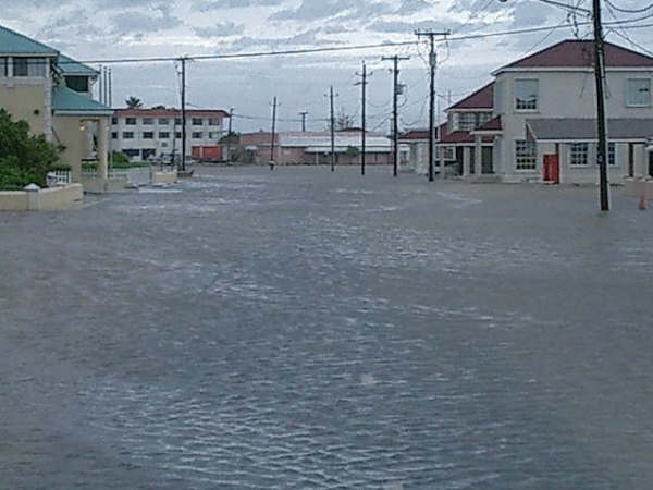
There is significant flooding on all the major islands. Flooding on Providenciales is due mainly to storm surge. The winds out of the southwest started the problems and winds out of the southeast, after approximately three hours of calm, finished the job. There are boats in Five Cays approximately one half mile inland from the shoreline. Lake Sahara/Juba Sound which was dry in certain sections due to strong winds from the southwest yesterday is now open ocean and is overflowing parts of Venetian Road. Residents in the Hawskbill area are cut off from the rest of the island.
The down area of Providenciales is flooded. Rainfall on Providenciales was light to moderate compared with rainfall on other islands in the chain.
Sections of Providenciales remain without electricity at this time. Some trees are down islandwide. Roofs have lost shingles, tar paper and tiles and in a few areas portions of roofs are damaged. There are confirmed reports of a house collapsing in the lower Bight area last night.
Residents on North Caicos had electricity restored earlier today. Trees are down and it is reported that the low lying southeastern end of North Caicos (Readymoney) is under water due to the tidal surge. I am told that a portion of the causeway, especially the part just out of North Caicos, has been washed away or has 'collapsed'.
Middle Caicos has minor structural damages to some houses and the primary school. Trees are down in certain areas.
South Caicos and Grand Turk are flooded and this is probably the case for Salt Cay. Some trees are down in Grand Turk and portions of Grand Turk remain without electricity.
Damages to resorts on Providenciales are superficial - signs down, some trees down, etc. Most resorts have backup generators and as such had electricity throughtout the night.
There are NO official reports of casualties in the Turks and Caicos Islands as a result of the presence of TS Hanna. Hurricane force winds did slam the islands yesterday and most of the night into the early morning. We are facing the music, dancing the 'two-step' and wondering what Hanna has left given that the storm appears to be meandering around us.
Schools will remain closed for the next day or two. There is much cleaning and clearing to do. Ike has his sights on us and residents will take every precaution to be fully prepared should he venture into our area.
What we have seen in the southern low lying areas of Providenciales and other islands give a clear understanding of the stories our parents tell of the tidal wave caused by Donna in 1960.
Thanks to all whose thoughts and prayers are with us. A special thanks to those who took the time to write.
Current conditions at Providenciales: winds 36 mph gusting to 51 mph from the ESE. Rainfall on Providenciales is estimated to be approximately 3.5 to 4 inches
|
Attachment:
Down Town 02.09.jpg
Description: JPEG image
Attachment:
Half mile inland from beach.jpg
Description: JPEG image
Attachment:
Venetian Road. going to Turtle Tail.jpg
Description: JPEG image
Attachment:
Surge aftermath .02.jpg
Description: JPEG image
Attachment:
Entrance to Post Office.jpg
Description: JPEG image
|
|
- Provo (fwd)
|
- From: Gert van Dijken <gert at vandijken.com>
- Date: Tue, 2 Sep 2008 10:28:39 -0400 (EDT)
|
Just received the following.

*
**
*** Gert van Dijken ( gert at vandijken.com )
**** Caribbean Hurricane Network - http://stormcarib.com


---------- Forwarded message ----------
Date: Tue, 2 Sep 2008 09:52:50 -0430
From: Linda Sonderman <linda.sonderman at alpi-group.com>
To: gert at gobeach.com
Subject: Provo

Gert,


Just got through to Provo via Skype and our friend's cel phone.  Here is
what he has to say: No casulties on Provo, lots of low-lying flooding and
trees down all over the island He feels the eye did pass over, but at 10 pm
last night for about 45 minutes.  Then rain and gusts all night.

Linda


Linda C. Sonderman
|
|
- Hurricane Hanna Update
|
- From: E Howell <howelledgar at yahoo.co.uk>
- Date: Tue, 2 Sep 2008 01:56:28 +0000 (GMT)
|
As I write the island of Providenciales is just now coming out of approximately three hours of dead calm. All this happened while Grand Turk and North Caicos were being lashed with srong winds and rain.
At present the winds are picking up again and rain is falling. Winds are out of the south to south-southeast and I suppose in a short while it will be as strong or stronger than it was earlier today. Power, television and internet are out in sections of Providenciales. Some families have reported to the official hurricane shelters for the night.
There are confrimed reports of power outages in North and Middle Caicos where some electric poles are down. Power is also reportedly out in Grand Turk.
It remains to be seen what Hanna will dish out during the night as it appears uncertain where the centre of the beast actually is at this time. God help us to get through the night and meet the morning light intact. Sustained hurricane force winds out of the south can only spell further problems for us.
We are urging everyone in the 'path' of the growing beast to be on guard.
Current conditions at Providenciales: winds 53 mph with gusts to 64 mph out of the south; barometric pressure is 985 millibars.
Next update will be with the rising sun. God speed!
|
Attachment:
TS Hanna.02 010.jpg
Description: JPEG image
Attachment:
TS Hanna.02 046.jpg
Description: JPEG image
Attachment:
TS Hanna.02 002.jpg
Description: JPEG image
Attachment:
TS Hanna.02 075.jpg
Description: JPEG image
Attachment:
TS Hanna.02 037.jpg
Description: JPEG image
|
|
- Indirect report from Pine Cay
|
- From: "William P.N. Smith" <w_smith at compusmiths.com>
- Date: Mon, 01 Sep 2008 21:37:16 -0400
|
I've attached a picture from a Webcam pointing south from Pine Cay,
along with a sample picture of a more normal day. There appears to
be quite a storm surge piling up on the iron shore and along the bank
side, from the West/South winds of today. Big waves for the bank
side, whitecaps, with Halfway Cay nearly disappearing under the
water, and bushes halfway up the iron shore now surrounded by water,
this is getting pretty major.
Weather data for today can be seen at
http://www.wunderground.com/weatherstation/WXDailyHistory.asp?ID=IPINECAY2
where "wind gust" is "Peak Wind Seen Today". Either the rainfall has
slackened off significantly, or the collector bucket blew off my rain
guage, as I haven't seen much rainfall since 2.00 inches, though my
cistern is still filling.
I'll post a movie of the day in 1-minute intervals once I get the
data together...Attachment:
GeekHo-20080901-1.jpg
Description: JPEG image
Attachment:
WebCam-1_08-07-22_12-00-52-00.jpg
Description: JPEG image
--
William Smith w_smith at compusmiths.com
ComputerSmiths Consulting, Inc. www.compusmiths.com
|
|
- Hurricane Hanna
|
- From: E Howell <howelledgar at yahoo.co.uk>
- Date: Mon, 1 Sep 2008 20:53:30 +0000 (GMT)
|
Things have gone down hill since my last report. The Turks and Caicos Islands continue to experience strong winds and light to moderate rain showers from hurricane Hanna.
Reports out of North Caicos are that the marina in Sandy Point has overflowed its banks, there are a few trees down and the causeway linking North and Middle Caicos is also under water at this time. Confirmed reports from Middle Caicos indicate that some houses on the ridge in Conch Bar have lost roofs or protions of their roofs.
Flooding has also plagued the island of South Caicos where a few trees are down and electricity has been out since morning.
There is severe flooding in the nation's capital - Grand Turk. The overflow of the ponds has resulted in flooding across Church Folly and Mission Folly. I am told that the NJS Francis Park is also under water. The high school is flooded and moderate rainfall has continued throughout the day with strong winds.
Due to the strong and constant winds out of the southwest, coupled with the rising tide, low lying areas on the southern side of Providenciales are flooded from tide waters. This is true for the south end of Five Cays, the road leading into Discovery Bay, Venetian Road near the Hawksbill area and the Caicos Marina and Ship Yard. Lake Sahara is flooded towards its eastern end and ocean water from the canal in Turtle Tail is pouring into and over the road. I have a few interesting pictures which will be uploaded during my next report. There are several trees down throughout the island and there are reports of damages to roofs in the Chalk Sound area. All flights have been cancelled out of and into the country.
Current condition at Providenciales: winds out of the southwest at 48 mphs gusting to 64 mphs; barometric pressure is at 29.02 inches.
Edgar V. Howell
"You have to decide what your highest priorities are and have
the courage -- pleasantly, smilingly, non-apologetically --
to say 'no' to other things. And the way you do that is by
having a bigger 'yes' burning inside."
- Stephen R. Covey
|
|
|
- Wind and rain lashing Turks and Caicos Islands
|
- From: E Howell <howelledgar at yahoo.co.uk>
- Date: Mon, 1 Sep 2008 13:49:21 +0000 (GMT)
|
Heavy rain and strong winds have been lashing the Turks and Caicos Islands for several hours now. The Blue Mountain area of Providenciales was without electricity for most of the night. Power has been restored in this area. There are confirmed reports of power outages in the Norway (Kew Town) area. There are also reports of cable TV being out in parts of the Blue Hills area and in Leeward Palms.
There is the usual flooding (minimal) of streets across Providenciales, dead leaves, dried palm branches and twigs are blowing about in some areas.
Grand Turk is also experiencing heavy rain with strong wind gusts This is also the case for North & Middle Caicos. Occasional thunder is heard over Providenciales, North and Middle Caicos.
The wave action along the southern coast of Providenciales has increased tremendously.
Current conditions at Providenciales: winds out of the southwest at 32 mph, gusting to 48 mph; barometric pressure is at 29.34 inches.
I am including a few photographs of different sections of the island of Providenciales. An update will be sent later today.
|
Attachment:
TS Hanna 021.jpg
Description: JPEG image
Attachment:
TS Hanna 022.jpg
Description: JPEG image
Attachment:
TS Hanna 029.jpg
Description: JPEG image
Attachment:
TS Hanna 031.jpg
Description: JPEG image
Attachment:
TS Hanna 033.jpg
Description: JPEG image
Attachment:
TS Hanna 040.jpg
Description: JPEG image
|
|
- Early morning update
|
- From: E Howell <howelledgar at yahoo.co.uk>
- Date: Mon, 1 Sep 2008 09:18:02 +0000 (GMT)
|
Storng gusts and rain throughout the night. Can't say whether TS Hanna has stalled or has every intention of lashing us with much needed rain. I am aware of one area of the island that lost electricity around 11 pm. This may have been a temporary issue.
Residents in the Turks and Caicos Islands are holding on to the reins. Look forward to a more detailed report after sunrise.
|
|
|
- Finally!
|
- From: E Howell <howelledgar at yahoo.co.uk>
- Date: Mon, 1 Sep 2008 00:49:12 +0000 (GMT)
|
I suppose Hanna has a phobia. With the setting sun came the rain, lightning and thunder. Rain is falling as I write and this is the case for most of the islands with the exception of Grand Turk. The capital had light rain (drizzle) during the day with wind gusts and overcast skies.
Some of our students must be happy that the scheduled reopening of school has been delayed due to the storm warning that is still in effect for the Turks and Caicos Islands.
Current conditions at Providenciales: winds out of the west-southwest at 23 mph, barometric pressure is 29.55 inches. Residents are keeping an eye on the weather channel and paying close attention to local advisories.
|
Send instant messages to your online friends http://uk.messenger.yahoo.com
|
|
- TS Hanna
|
- From: E Howell <howelledgar at yahoo.co.uk>
- Date: Sun, 31 Aug 2008 17:09:46 +0000 (GMT)
|
We have yet to see rain, lightning or hear thunder from the cloud cover associated with Hanna. Skies are still overcast. The winds are out of the west-northwest at 13 mph with gusts up to 20 mph.Waves breaking over the reef are a little more active than they were this morning. We are praying for our family and friends in the central Bahamas as Hanna appears to headed in that general direction.
|
|
|
- Update...
|
- From: E Howell <howelledgar at yahoo.co.uk>
- Date: Sun, 31 Aug 2008 11:09:25 +0000 (GMT)
|
Current condition at Providenciales: Overcast skies with winds out of the northwest at 8 mph. Barometric pressure is 29.67 inches and falling. The birds are having a wonderful time - I wonder if they are making last minute preparations? Perhaps they are excited about how cool the morning is and the possibility of rain.
|
|
|
- Calm...
|
- From: E Howell <howelledgar at yahoo.co.uk>
- Date: Sat, 30 Aug 2008 23:55:31 +0000 (GMT)
|
The daylight has ended - peaceful and calm. There are no visible signs of an approaching storm except for the satellite view and the occasional mention on the weather channel. Hanna has a mind of her own and speculations are running wild. We are preparing for whatever comes our way including clear skies and sunshine.
It appears there has been a slight drift south of the expected track. Let's pray this is only temporary.
|
|
|
- Update
|
- From: E Howell <howelledgar at yahoo.co.uk>
- Date: Sat, 16 Aug 2008 02:29:42 +0000 (GMT)
|
The current situation at Providenciales is overcast skies with thunder and lightning and a squall of rain. Wind gust in this first band of rain was clocked at 36.0 mph. I hope this is not the last of the rain from Fay.
The storm is well to the south of the Turks and Caicos. We wish our friends in the DR and Haiti a safe journey through the night. We will be watching out for your updates.
Stay safe!
|
Send instant messages to your online friends http://uk.messenger.yahoo.com
|
|
- POISED FOR RAIN?
|
- From: E Howell <howelledgar at yahoo.co.uk>
- Date: Fri, 15 Aug 2008 15:55:22 +0000 (GMT)
|
Since my last entry we have almost forgotten what it is like to have rain. The days have been hot and humid and at times unbearable. Thank God for the cooler turquoise sea lapping our shores.
With the strengthening tropical system to the ESE our prospects are beginning to look brighter. There is an element of unpredictability when it comes to weather in these parts and so we will wait to see what happens next.
Providenciales is currently experiencing sunny skies with scattered clouds, Temp: 96.0 °F, Heat Index:116 °F, Winds:14.0 to 15.0 mph from the ENE, Barometric Pressure: 29.99 in.
There are confirmed reports of rain in the Nation's Capital earlier today. There are also reports
of some government offices are being fitted with storm shutters.It is quite likely that the mountains of Hispaniola will have a significant impact on this system and so...
|
Send instant messages to your online friends http://uk.messenger.yahoo.com
|
|
- Green scenery and chirping birds
|
- From: E Howell <howelledgar at yahoo.co.uk>
- Date: Sat, 7 Jun 2008 18:45:15 +0000 (GMT)
|
A pleasant afternoon. A mid/upper level low to the northwest of the islands will influence our weather conditions later today. Scattered showers and possible thundershowers are expected this afternoon and into the night. We are giving thanks for every drop of rain that gets squeezed out of the clouds as they pass by us. Residents in the Capital were more than happy for the rain they got this week.
Current conditions: Temp.: 88°F, Pressure: 30.06 inches (falling), Wind direction: SSE
|
Sent from Yahoo! Mail.
A Smarter Email.
|
|
- It's Raining Again
|
- From: E Howell <howelledgar at yahoo.co.uk>
- Date: Wed, 4 Jun 2008 10:26:22 +0000 (GMT)
|
After a long dry period we are finally getting rain. Moisture in the region has resulted in afternoon showers for the past week. We have even had thunderstorms over the larger islands at times. The rain is welcome. In addition to all the other things it helps us forget how hot the days are if only for a while.
|
Sent from Yahoo! Mail.
A Smarter Email.
|
|
