
|
- - - 2010 Hurricane Season - - -
|
- Update
|
- By <markbgi at caribsurf.com>
- Date: Tue, 21 Dec 2010 12:11:29 -0500
|
|
|
|
- Update 2
|
- By "Mark M " <markbgi at hotmail.com>
- Date: Tue, 21 Dec 2010 17:10:29 +0000
|
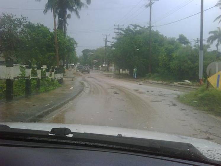
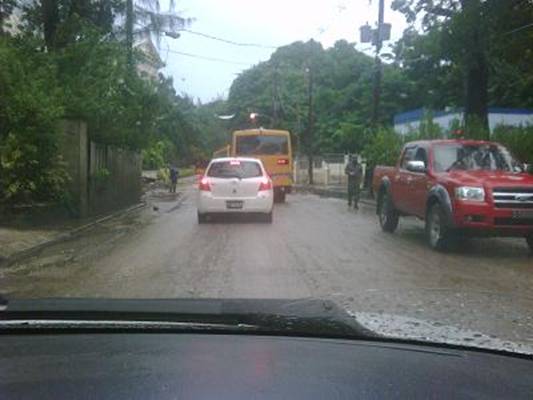
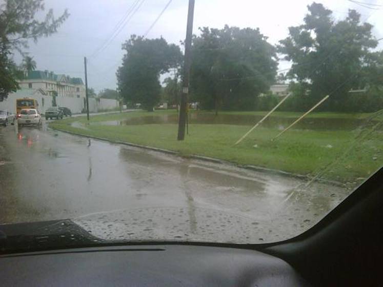
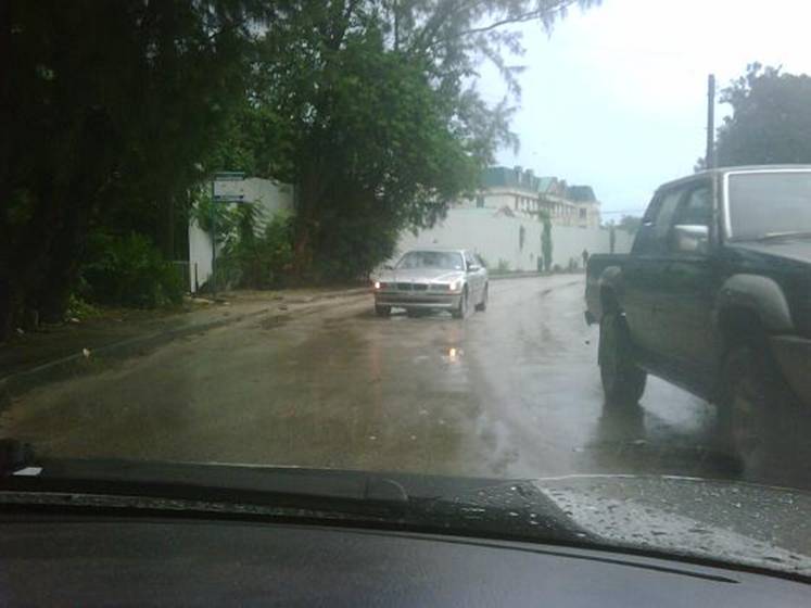
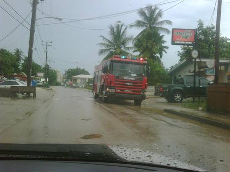
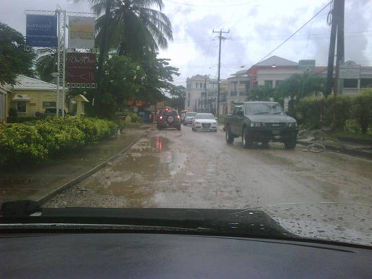
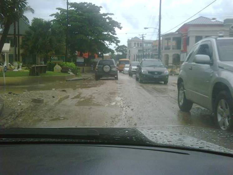
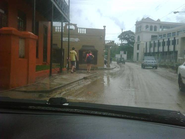
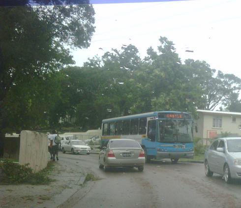
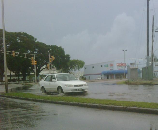
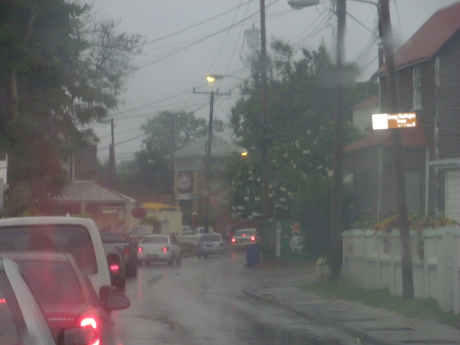
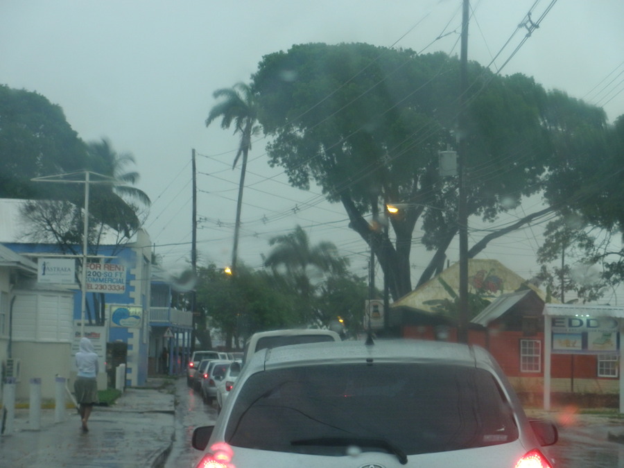
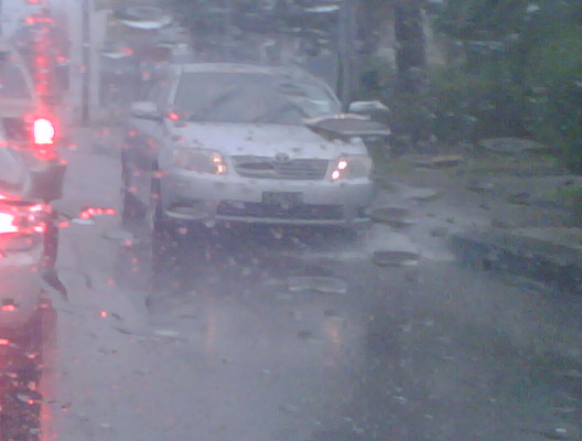
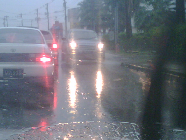
Heavy rain over Barbados. Its now fully overcast and some flooding of roadways
in Speightstown and Hwy 1 west coast. The met office issued a Special Weather
Bulletin at 10AM but is still to issue a flood warning/watch at this time.
Sent from my BlackBerry® wireless device from LIME.
|
|
- Potential for Bad Weather
|
- By "Mark M " <markbgi at hotmail.com>
- Date: Tue, 21 Dec 2010 11:19:03 +0000
|
The National Hurricane Center is advising on a low pressure system east
southwest of Barbados. The system has a 30% chance of tropical cyclone
formation within the next 48hrs. Heavy rainfall and gust winds are expected
even if the system fails to intensify.
Sent from my BlackBerry® wireless device from LIME.
|
|
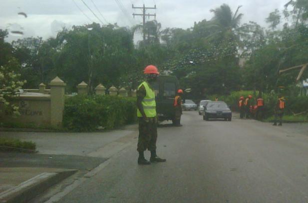
- Barbados Bouncing Back
|
- By <markbgi at caribsurf.com>
- Date: Mon, 1 Nov 2010 19:41:38 -0500
|
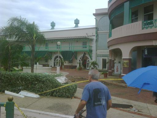
Power has been restored to approx 90% of Barbadian
customers. Very few residences and businesses are without water or electricity
as of 7PM Monday Nov 1st.
Schools in Barbados will remain closed tomorrow, Tuesday, as
cleanup efforts continue and also on Wednesday when the funeral service for our
late Prime Minister the Hon. David Thompson is held at the Kensington Oval and
St John’s Parish Church.
All government services will also be closed on Wednesday due
to the funeral service whilst some private business are opting to open at 1PM
following the service.
|
|
|
- Barbados slowly returning to normal
|
- By <markbgi at caribsurf.com>
- Date: Sun, 31 Oct 2010 08:06:18 -0500
|
|
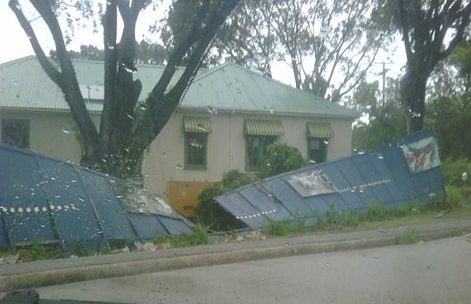
Overcast skies and periods of light drizzling rain.
A floodwatch have been extended until 12 noon. Electricity still out in most of
the north but crews are pushing north and power is slowly being restored. Downed
powerlines will not make this task any easier so we are expecting power to be
out for some time. Some supermarkets, hardware and general stores are
opening at 9AM.
Government transport was expected to restart
at 7AM. The Grantley Adams International Airport has reopen and are
expecting flights from around 8AM.
Barbadians are out and about assessing damages and
hammering and general cleanup operations are on the way. There are reports of 2
open fissures at Wharf Road in Bridgetown and traffic have been diverted
around the affected area. No reports from SLU or SVG as yet.
Caribbean Broadcasting Corporation located in Barbados has boosted its 900 AM
radio station to cover St Lucia as initial reports indicated that radio stations
there were off air.
Thats it for now.
|
|
|
- Update
|
- By "Mark M " <markbgi at hotmail.com>
- Date: Sun, 31 Oct 2010 02:26:57 +0000
|
Sporadic rain and high winds still lashing Barbados. Wind is extremely strong.
Approx 60-65 % still without electricity mostly in north and northwestern
Barbados. It's dark, very dark and the howling winds bear no comfort. Only the
occasional flah of lightning brightens the northern sky. Continue to pray for
SLU SVG and the other islands west or Bdos. .
Sent from my BlackBerry® wireless device from LIME.
|
|
- Barbados Update
|
- By "Mark M " <markbgi at hotmail.com>
- Date: Sat, 30 Oct 2010 18:34:24 +0000
|
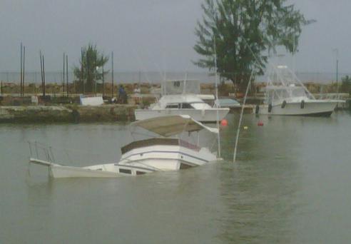
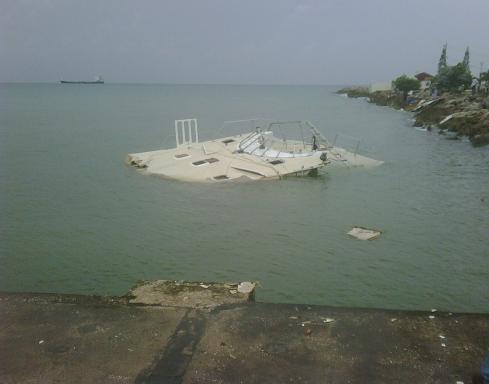
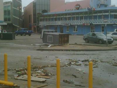
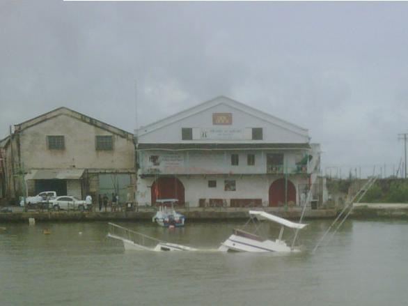
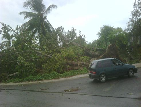
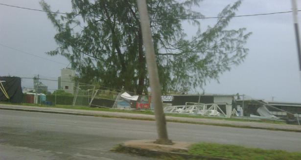
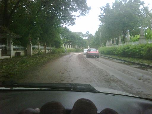
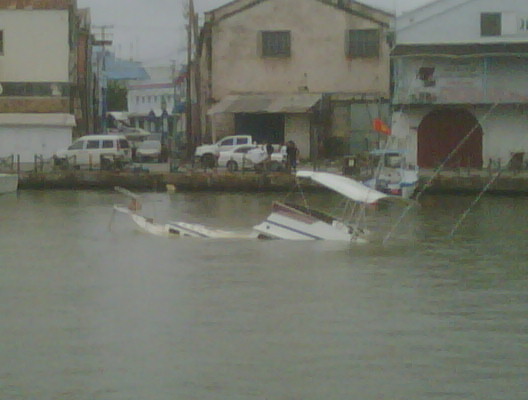
ALL CLEAR given by Prime Minister Stuart from DEMA hq. Rain continues... Storm
surge battering boats in careenage Bridgetown. PM lists parishes hardest hit by
Tomas. PM says assistance is on the way. Reports of broken trees and scattered
vegetation along ABC hwy (our major hwy). PM says normalcy will take time to
return.
Sent from my BlackBerry® wireless device from LIME.
|
|
- Barbados Update
|
- By "Mark M " <markbgi at hotmail.com>
- Date: Sat, 30 Oct 2010 18:33:06 +0000
|
ALL CLEAR given by Prime Minister Stuart from DEMA hq. Rain continues... Storm
surge battering boats in careenage Bridgetown. PM lists parishes hardest hit by
Tomas. PM says assistance is on the way. Reports of broken trees and scattered
vegetation along ABC hwy (our major hwy). PM says normalcy will take time to
return.
Sent from my BlackBerry® wireless device from LIME.
|
|
- Barbados Update
|
- By "Mark M " <markbgi at hotmail.com>
- Date: Sat, 30 Oct 2010 18:32:45 +0000
|
ALL CLEAR given by Prime Minister Stuart from DEMA hq. Rain continues... Storm
surge battering boats in careenage Bridgetown. PM lists parishes hardest hit by
Tomas. PM says assistance is on the way. Reports of broken trees and scattered
vegetation along ABC hwy (our major hwy). PM says normalcy will take time to
return.
Sent from my BlackBerry® wireless device from LIME.
|
|
- Barbados Update
|
- By Gert van Dijken <gert at vandijken.com>
- Date: Sat, 30 Oct 2010 12:01:51 -0400 (EDT)
|
---------- Forwarded message ----------
Date: Sat, 30 Oct 2010 11:36:20 -0400
From: George K. Fergusson <fergus34 at hotmail.com>

As of today Saturday the morning weather has changed for the better here for
us in Barbados. The wind is still blowing but nothing like what it was at
around 3 am. Here in Rendezvous, Christ Church a few tree top were blown off
and we have electricity since 8 o'clock this morning. Hopefully the worst is
behind us.

prayers answered
|
|
- Update
|
- By "Mark M " <markbgi at hotmail.com>
- Date: Sat, 30 Oct 2010 11:42:59 +0000
|
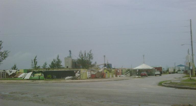
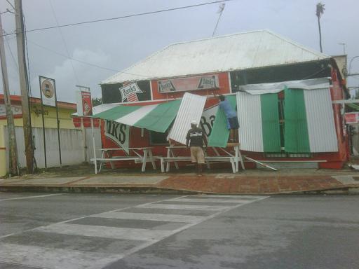
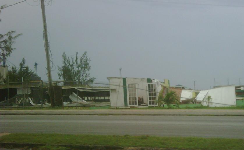
Widespread devastation. Intense winds accompanied by rain. No thunder or
lightning. Barbados is being hit hard by Tomas.

It is extremely serious across Barbados. DEMA is warning bajans to stay put.
Sent from my BlackBerry® wireless device from LIME.
|
|
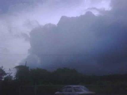
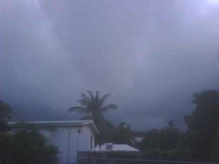
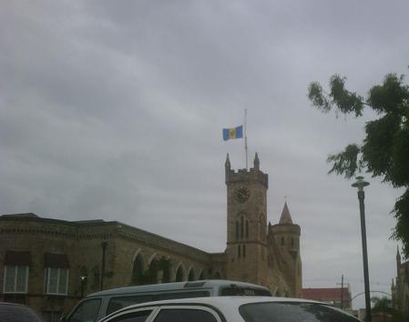
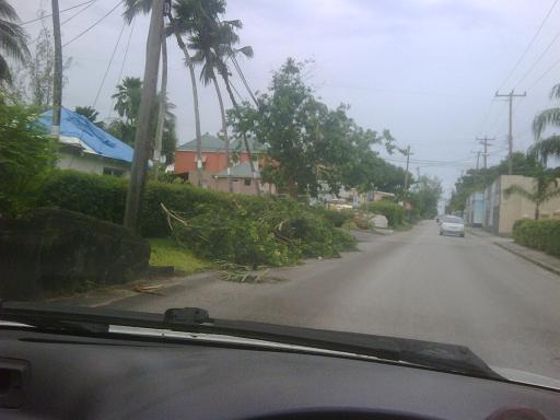
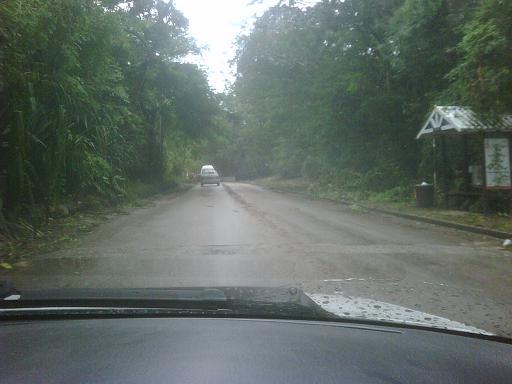
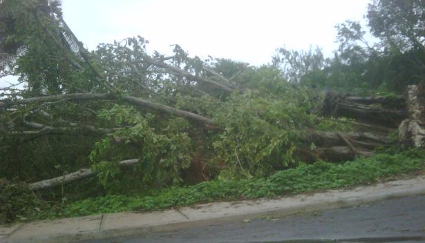
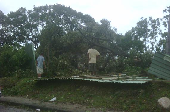
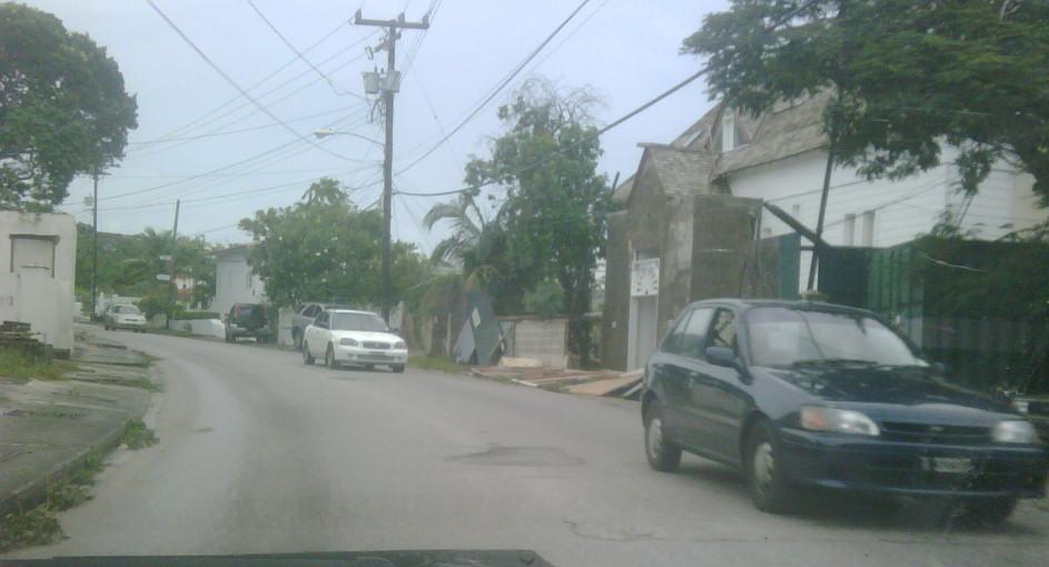
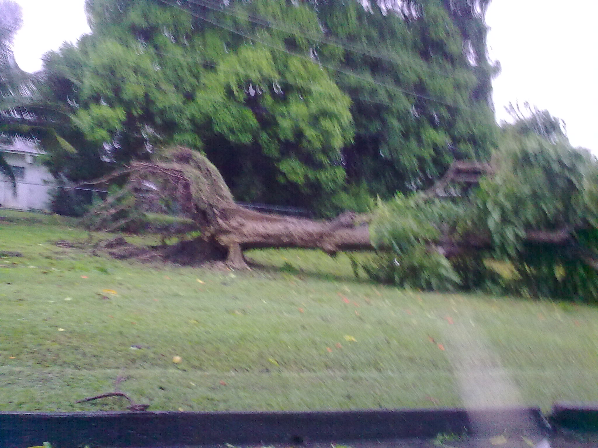
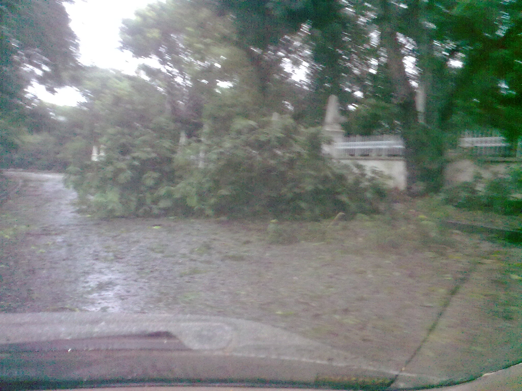
- First images
|
- By "Mark M " <markbgi at hotmail.com>
- Date: Sat, 30 Oct 2010 10:58:41 +0000
|
Sent from my BlackBerry® wireless device from LIME.
Attachment:
30102010374.jpg
Description: =?utf-8?B?MzAxMDIwMTAzNzQuanBn?=
Attachment:
30102010369.jpg
Description: =?utf-8?B?MzAxMDIwMTAzNjkuanBn?=
|
|
- Current Conditions
|
- By "Lisa Greaves" <lgwbajan at yahoo.com>
- Date: Sat, 30 Oct 2010 10:17:37 +0000
|
Woke up to numerous reports of roofs missing, tree branches snapped and a few
light poles on fire...Apparently, the devastation is widespread...Winds gusting
to 70 MPH and power off in most locations.

In the South East where I am, the winds are howling and the rain looks
white..We have been informed to expect these conditions for another 12 hours.


Sent from my BlackBerry® wireless device from Cable & Wireless
|
|
- Current Update
|
- By "Mark M " <markbgi at hotmail.com>
- Date: Sat, 30 Oct 2010 09:05:53 +0000
|
Electricity off in most parts if not islandwide. Winds are extremely high and
constant. Reports indicate roofs off, trees down and damage across the island.
Guys this seems to be the big one.
Sent from my BlackBerry® wireless device from LIME.
|
|
- Home alone
|
- By Eye Write <eyewatcheyewrite at gmail.com>
- Date: Sat, 30 Oct 2010 05:02:29 -0400
|
Wind howling. Pitch black. Flashlight beside me. Can hear the ppl who
live around me talking.
Wish I could actually see something but it's so dark.
Probably the loudest wind I have heard. Barbados got a piece of
hurricane allan in 1980, the year I was born. Now, here we are 30 yrs
later!
|
|
- Re: tomas
|
- By "Lemuel Taylor" <lem_rt at hotmail.com>
- Date: Sat, 30 Oct 2010 04:44:15 -0400
|
I’m in St.Michael on the southwestern part of the island. In the last hour
we have been in the “calm” of the eye. It’s been gusty still but winds are
a lot less and weaker. We went through the western eye-wall after 2 and
that was really amazing. As I speak now the winds have begun to gust hard
again, now from the SE, so I think the back end is ready for us now. From my
observations we have a hurricane now. So far, we have trees down in
different parts, electricity is off in some parishes, some houses are
experiencing damage. I’ll try to keep you and everyone informed as best I
can.
Regards,
Lemuel R. Taylor
Sent: Saturday, October 30, 2010 4:38 AM
Subject: tomas
|
|
Just read yr blog.How is it now? where in Barbados
are you What is the latest situation there?
Sincerely

Technical Consultant-International Truck
Sales
Tracmac Engineering
Ltd
Uriah Butler Highway,
Chaguanas
P.O. Box 945 Port Of
Spain
Trinidad, West
Indies
Phone: 665-5555 Ext
743
Mobile (868) 320 0184,
Fax:
(868)
671-8505
Visit
www.internationaltrucks.com

International Trucks
Don't just drive.ride.
Please consider the
environment before printing this e-mail
|
| |
| |
|
|
|
|
- Eye-Wall
|
- By "Lemuel Taylor" <lem_rt at hotmail.com>
- Date: Sat, 30 Oct 2010 03:31:54 -0400
|
Right now we are being hammered by the developing eye-wall of what I
believe is now Hurricane Tomas. Winds are ferocious and last I checked are
sustained around 60-65 mph where I am. Gusts are well above 80 mph and with
winds from the NW, it means we are still only on the weak side of the
storm. Transformers are blowing out like crazy and lots of thumps and
crashes outside. God be with the other Islands who now have to face
this.
LemieT
|
|
|
- South East
|
- By "Lisa Greaves" <lgwbajan at yahoo.com>
- Date: Fri, 29 Oct 2010 23:09:26 +0000
|
Have not long reached home in the South East, but the wind has certainly picked
up considerably in the last few minutes..Strong enough to blow over some
plants...I stopped at the Gas Station and had to wait a while as everyone
seemed to have the identical idea...We will see how the next few hours play out.
Sent from my BlackBerry® wireless device from Cable & Wireless
|
|
- Barbados Update
|
- By <markbgi at caribsurf.com>
- Date: Fri, 29 Oct 2010 18:27:05 -0500
|
|
Lemuel T said
we have been caught with our pants down this time but it looks
like the pants is actually OFF on this occasion.
Light drizzles
on the West Coast accompanied by occasion high wind. Reports of some network
issues with LIME so services are affected some parts of the island. Gas
stations are doing a brisk trade and traffic is heavy up and down. I guess
bajans are trying to get some tin food and batteries just
incase.
The storm seems
to be heading South of Barbados and that is not usually a good sign as we get
the very worst when this happens. Off to get some batteries so
everyone stay safe. Will update u as long as the network
holds.
|
|
|
- Weather Deteriorating
|
- By "Lemuel Taylor" <lem_rt at hotmail.com>
- Date: Fri, 29 Oct 2010 17:48:01 -0400
|
Well folks, here in Barbados, the weather is going downhill fast. We were
let out from work 30 mins early today after receiving a TS Warning.
I have been warning friends and family of the impending weather for at
least 2 days. Protocol and statistical correctness meant that we in the
Caribbean have been in informed at the last possible minute. Talk about getting
caught with pants down. Well we can fully identify now with the northern
islands who had their fair share with EARL. TOMAS looks to be nothing but
trouble now and down the road. My prayers are with everyone in his path.
LemieT
|
|
|
- TS Thomas
|
- By Donna Tull-Cox <dondonqt at gmail.com>
- Date: Fri, 29 Oct 2010 15:34:59 -0400
|
Just heard on the radio that we now have TS Thomas bearing down on
Barbados. Outside has gotten very overcast and there have been a few
gusty squalls. There should be an advisory around 5 PM.
Donna
|
|
- Wild, Windy , Wet and Noisy. (fwd)
|
- By Gert van Dijken <gert at vandijken.com>
- Date: Mon, 4 Oct 2010 12:58:15 -0400 (EDT)
|
---------- Forwarded message ----------
Date: Mon, 4 Oct 2010 14:56:53 +0000
From: Trevor Whiteside <trevorwhiteside at hotmail.com>
Subject: Wild, Windy , Wet and Noisy.

Well that was an interesting night and early morning up north in Barbados,
although I believe all parts had a similar hit. Thunder and lightning last
night felt as if it was on top of the roof. Saw an amazing sight and was
glad to be well enough away, when a lightning strike came out of the sky
like a scud missile and hit the electricity transformer at the top of
Maynards near Jerusalem. As if a missile had struck there was a loud
explosion and a dome of light above. Everything then went black as all
lights went out at that instant. Electricity came back on within the hour.
We had a real breeze this morning and heavy rain but that passed by perhaps
an hour ago. All calm now. Can't see any damage about.

Regards,

Trevor
|
|
- Wild Weather
|
- By "Lemuel Taylor" <lem_rt at hotmail.com>
- Date: Mon, 4 Oct 2010 09:43:55 -0400
|
|
Well this is some amazing weather. My
internet was knocked out last night by some lightning which for most of the
night was persistent with a few seconds between flashes. Thunder was a
constant rolling in the heavens.
This morning, the rain is pouring and for the last
half hour or so, we have had tropical storm force winds in the 45-50 mph
range. This is amazing!!! We have schools closed, businesses doing the
same and treacherous conditions all around.
Hoping my brothers and sisters in the islands are
doing well. We have had some major flooding over the course of the last 48
hours, and today looks worse than yesterday, at least in the southern
parishes.
LemieT
|
|
|
- Barbados Flooding
|
- By <markbgi at caribsurf.com>
- Date: Mon, 4 Oct 2010 08:36:24 -0500
|
We are under flood warning/watch for the 4th
straight day. Serious flooding have been occurring daily since Friday. St James
seems to have been hardest hit overnight with most roads filled with debris. Businesses
and residences doing cleanup work along HWY 1.
Business will open at 12PM today and all schools are closed
today.
|
|
|
- Flooding and drama!
|
- By "Dondonqt" <dondonqt at caribsurf.com>
- Date: Sat, 2 Oct 2010 17:58:24 -0300
|
Happy overcast day from Bridgetown Barbados!
We have had several bouts of intense rainfall over
the past twenty-four hours. We are currently under flood watch until 6 PM.
Here in St Thomas we have been cleaning up our
basement from yesterday afternoon’s flooding. So much rain fell in such a
short period of time that our drains were overwhelmed and the basement was
under about 6 inches of water! Luckily there was no furniture in there as yet.
Everybody pitched in to help scoop, sponge, push and pump water out and as we were
nearly finished we were greeted with dark heavy clouds and more rain! J The kids called it a weather Kadooment cause
the rain was ‘wukking up’ as it liked. Thank
the Lord that good friends make hard work light. Took us last night and all day
today, but the basement is just about dried.
Here is the link to a rescue that took place
yesterday because of the flash flood due to the intense rainfall. This was in
the area called the Belle. I use that road a mere hour two hours before rain fell.
http://www.youtube.com/user/CBCBARBADOS?feature=mhum#p/a/u/0/gajn8X3ut9k
Stay
safe and dry
Donna
in Bim
|
|
|
- Flood watch for Barbados extended
|
- By Eye Write <eyewatcheyewrite at gmail.com>
- Date: Tue, 21 Sep 2010 19:50:57 -0400
|
The flood watch which was originally scheduled to end at 4:00 p.m. today, Tuesday, September 21, has been extended to tomorrow, Wednesday, September 22 at 6:00 a.m. and may be extended even further according to MET services reports.
Some parts of the island have reported major flooding. I know of at least one person who had difficulty getting out of her home today. It is the first time in a while that we have experienced overcast conditions from morning until night.
|
|
- Squall
|
- By "Lemuel Taylor" <lem_rt at hotmail.com>
- Date: Fri, 17 Sep 2010 10:25:08 -0400
|
|
Seems that Igor peeped at the Caribbean and wished
he could visit. He's thrown back a nice feeder band and for the last 30
minutes, it's been rain, wind and thunder here.
Our prayers are with Bermuda as Igor approaches,
and with Mexico as they cope with Karl.
LemieT
|
|
|
- Flood watch discontinued
|
- By Eye Write <eyewatcheyewrite at gmail.com>
- Date: Thu, 9 Sep 2010 20:23:11 -0400
|
There was a flood watch for Barbados until 4 p.m. today.At first there were expectations that the flood watch would be extended but it was discontinued by the MET services this afternoon.
Woke up this morning to dry taps and intermittent showers. Actually, water is not back on in my neighbourhood yet last time I checked. Good thing I had water stored and bought a case of bottled water at the start of the hurricane season.
There were also reports of major flooding and crop damage. According to news reports, some produce may be scarce and more expensive. We were surprised to see the level of flooding that occured in some southern and northern areas as shown in this link from www.barbadostoday.bb
http://edition.pagesuite-professional.co.uk/launch.aspx?referral=other&refresh=sZ0431yPw5N0&PBID=87ad6005-1972-4d63-92b0-8927eda53c7a&skip=
|
|
- Statement from Barbados MET Office
|
- By Eye Write <eyewatcheyewrite at gmail.com>
- Date: Wed, 8 Sep 2010 22:26:39 -0400
|
A statement was issued between 4.00 and 5:00 p.m. this afternoon.
The unsettled weather conditions affecting the
island are associated with a low level trough across the southern part of the
Eastern Caribbean.
Inclement conditions are
therefore expected to persist during the night and into tomorrow, during which
time some pockets of moderate to heavy showers, periods of rain and isolated
thunderstorms can be expected.
Just after 12:30 this afternoon we got a scare from a lightning bold and thunder roll. It was the loudest I have heard in a long time. Up to now my computer at work has not recovered.
|
|
- Rain
|
- By Lemuel Taylor <lem_rt at hotmail.com>
- Date: Wed, 8 Sep 2010 18:27:15 +0000
|
It's amazing how things can happen. today started out relatively sunny and bright, suddenly it's rain, lightning and thunder.
There are isolated reports of flooding in some areas of the island.
According to some weather experts, this area of disturbed weather currently affecting the southern islands has potential to become a tropical cyclone.
Since this is September, it means we must keep our eyes and ears open constantly.
LemieT
|
|
|
- Changing weather
|
- By Eye Write <eyewatcheyewrite at gmail.com>
- Date: Tue, 31 Aug 2010 19:17:51 -0400
|
The day started out with intense humidity and blazing sun. (the past few days have been like that). Then around 1:50 p.m. rain drops appeared, which was not really surprising because there were some huge dark clouds as well. Thunder and lightning followed soon after and until now the sky is still flashing but very little rain.
|
|
- Heavy downpour
|
- By Eye Write <eyewatcheyewrite at gmail.com>
- Date: Thu, 19 Aug 2010 15:17:08 -0400
|
|
Yesterday was very hazy and even though the night was relatively warm, the humidity was broken by an occassional breeze. Today started out nice and toasty. Not too warm, just warm enough. Then around 12:40, I felt the first few rain drops and shortly after, there was a heavy downpour which flooded some south coast streets. The sun is out now just barely as the rain continues to fall and the skies remain grey. It has rained a lot in the past few days but this is the heaviest downpour I think for a little while.
|
|
- Amazing lighting show
|
- By Eye Write <eyewatcheyewrite at gmail.com>
- Date: Tue, 17 Aug 2010 08:50:55 -0400
|
|
Watched the lightning show from my bedroom window last night. Talk about some bright sparks! There were also some heavy showers just before 6.00 p.m. yesterday evening and this morning after 1.00 a.m. At this time, there's not much rain in this area but the roads are still wet.
|
|
- Let in the breeze!
|
- By Eye Write <eyewatcheyewrite at gmail.com>
- Date: Sat, 14 Aug 2010 11:04:42 -0400
|
It's overcast and grey and the rain is gently falling. I can hear thunder in the distance and there's a soft breeze. Wouldn't mind if this continues for the rest of the day.
|
|
- Hottest day of the week?
|
- By Eye Write <eyewatcheyewrite at gmail.com>
- Date: Thu, 12 Aug 2010 17:22:57 -0400
|
|
I remember yesterday afternoon being quite sunny, but could today be the hottest day of the week? I got in my car today to run an errand around 2:30 p.m. (it is usually hot around that time anyway) and both my passenger and I got burnt! I guess that's what happens when you forget to put up your sun shade. I suppose it's summer, so the days are longer. It's nearly 5:30 and the sun is still shining bright through the window like it is midday.
|
|
- Unexpected thunder
|
- By Eye Write <eyewatcheyewrite at gmail.com>
- Date: Tue, 10 Aug 2010 11:48:06 -0400
|
|
Rolling thunder is taking some people by surprise as today has so far been a toasty, sunny day and so far it is not raining in my area. Skies on the left are blue and on the right, skies are grey and getting darker and darker. Just heard that there has been flooding in the area of St. James.
|
|
- Travelling showers
|
- By Eye Write <eyewatcheyewrite at gmail.com>
- Date: Sun, 8 Aug 2010 22:49:52 -0400
|
I was outside this evening just chatting with a relative ...and for most of the evening there were drizzles of rain, cool breezes and flashes of lightning in the distance. Then just after 7:30 p.m., the flashes got nearer and nearer and we could hear the showers approaching! It started off with a mild roar until eventually the rains caught up with us and we ventured back inside the house. The lightning then felt even nearer to us, as if it were flashing in the house! At first, we thought that we would have to brace for a power outage, but then it got pretty quiet and the skies seem to be settling down a bit.
|
|
- Maybe this Crop Over weekend will be a cool one!
|
- By Eye Write <eyewatcheyewrite at gmail.com>
- Date: Fri, 30 Jul 2010 15:59:22 -0400
|
Intermittent showers still going on here. It's, cloudy, cool and breezy. I think the revellers will get a good combination of rain and sun this weekend. 
|
|
- Woke up to heavy showers this morning.
|
- By Eye Write <eyewatcheyewrite at gmail.com>
- Date: Fri, 30 Jul 2010 09:33:03 -0400
|
|
At one point, a thunder roll clapped so loud, I almost fell off the bed! It jumped the living daylights out of me! LOL Right now, it's "Partly Sunny" and from my window, I can see trees swaying, so I guess it is breezy too.
|
|
- Supposed to be under flood watch until 4:00 p.m.
|
- By Eye Write <eyewatcheyewrite at gmail.com>
- Date: Thu, 29 Jul 2010 13:58:38 -0400
|
|
I haven't heard anything more since the update in the 12:30 news.
This information compliments www.cdera.org . (There is a message at the top indicating that the flood watch has been discontinued but when I click on it, that discontinued watch was for July 9. ??? )
| Barbados Forecast for Thursday 29th July, 2010. |
|
|
| Synopsis: |
The ITCZ is affecting the island. |
| Weather: |
This Afternoon and Tonight: Generally cloudy to overcast with periods of moderate to heavy showers,periods of rain and isolated thunderstorms. |
| |
In-depth weather discussion |
|
| Wind: |
ENE- E at 15-35 km/h. |
| Sea: |
Moderate in open water with swells 2.0-2.5m. Smallcraft operators and sea bathers should exercise caution. |
| High tides: |
05:30 hrs 18:10 hrs |
| Low tides: |
11:36 hrs 23:56 hrs |
| Rainfall ending 6 am today: |
3.6 mm |
| Total rainfall for the month: |
247.8 mm |
| Total rainfall for the year: |
684.8 mm (Thu Jul 29, 2010) |
| |
| Meteorologist: |
Rosalind Blenman |
|
|
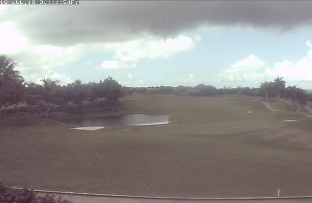
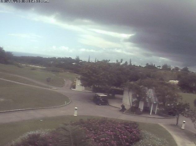
- Barbados Today
|
- By <markbgi at caribsurf.com>
- Date: Mon, 19 Jul 2010 13:47:12 -0500
|
|
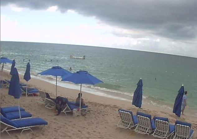
Here are a few screen captures from local cams.
Looking bad on the westcoast....
|
|
|
- Barbados Weather
|
- By <markbgi at caribsurf.com>
- Date: Mon, 19 Jul 2010 13:37:29 -0500
|
|
Thunder and dark clouds over the north western
areas of the island. No word from the met office as yet so i will go ahead and
issues a Citizens Advisory.
CITIZEN'S ADVISORY - ISSUED AT 1:31PM JULY 19TH
A Citizen's Advisory for extreme flooding/flash
flooding is now in effect for western and north western areas of
Barbados. This warning will continue until 5PM today and may be
extended as necessary. Persons in low-lying areas are asked to take the
usual precautions and to expect flood water levels to rise quickly.
|
|
|
- Lonnnnnng Thunder
|
- By Eye Write <eyewatcheyewrite at gmail.com>
- Date: Sun, 18 Jul 2010 07:44:33 -0400
|
Just after 11:00 last night then rain poured heavily. There was one lonnnngg roll of thunder that I thought would never stop. The lightening flashed so quickly, it was easy to miss it. I remember blinking and seeing a vibrant blue while my eyes were closed. It seemed so near, I felt like it was in my room. We had to place containers around the house because the roof/ceiling started to leak. This morning it is VERY humid and hot. Very little breeze, if any at all. My peeps are hoping that it won't be rainy, muddy and soggy for Soca on the Hill today.
|
|
- Night Showers
|
- By Eye Write <eyewatcheyewrite at gmail.com>
- Date: Tue, 13 Jul 2010 22:34:17 -0400
|
Seems like Dominica has been getting much drama lately!
Here tonight, just a few gentle rain showers. Some days certain areas are overcast.
|
|
- Barbados Update
|
- By <markbgi at caribsurf.com>
- Date: Fri, 9 Jul 2010 13:15:37 -0500
|
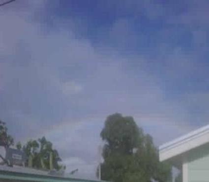
The morning started with a beautiful rainbow but conditions
have since deteriorated. Its now overcast across the island with sudden
bursts of rain and high winds.
The Met Office has issued a FLOOD WATCH until 6PM but “may be extended if
conditions warrant.” SEE BELOW.
A
FLOOD-WATCH IS IN EFFECT FOR BARBADOS UNTIL 6:00P.M TODAY
Issued:
12:00 NOON FRIDAY JULY 9TH, 2010.
The
conditions which are presently affecting the island are associated with the
interaction of a tropical wave and an upper-level trough.
Moderate
to heavy showers, periods of rain, isolated thunderstorms and occasional gusty
winds are expected to persist for at least another 12 to 18 hours.
Thus,
residents in low-lying areas should exercise caution and take all necessary
precautions.
This watch
is in effect until 6:00p.m, today July 9th, 2010 and may be extended if
conditions warrant.
Sonia
Nurse
Deputy
Director (Ag)
|
|
|
- Rain and winds picking up
|
- By Eye Write <eyewatcheyewrite at gmail.com>
- Date: Thu, 8 Jul 2010 16:10:35 -0400
|
|
The winds just picked up suddenly and some more rain came with it. Just looked outside and saw a visitor still lying on the beach with a colourful umbrella. I agree, I wouldn't let it rain on my parade either! Now all of a sudden, it's quiet again.
|
|
- Midday Showers
|
- By Eye Write <eyewatcheyewrite at gmail.com>
- Date: Thu, 8 Jul 2010 15:02:10 -0400
|
|
Just after midday, we had some intermittent showers. There were grey clouds and the palm tree branches were moving gently in the wind. Then around 12:05, while passing by the Queen Elizabeth Hospital, there was a sudden, heavy shower that lasted about five minutes. The sun then came out brightly, but a few raindrops keep teasing us now and then.
|
|
- Latest Weather Barbados - South of Island
|
- By Gail Thomas <gailforce5 at yahoo.com>
- Date: Mon, 5 Jul 2010 08:31:01 -0700 (PDT)
|
After nearly a whole day of rain and thunderstorms yesterday, TODAY has returned to Hot and Humid . Mixture of cloudy and blue sky with a slight breeze.
Sea is calmed down and is slight to moderate. 3-4
regards from gailforce5 on island
|
|
|
- Wet, breezy Sunday Afternoon
|
- By Eye Write <eyewatcheyewrite at gmail.com>
- Date: Mon, 5 Jul 2010 09:20:52 -0400
|
|
Dark clouds, thunder and lightning. I think crabs like this kind of weather. There were so many kinds playing in the sand. Here, one poses for a photograph.
Attachment:
Mrs. Crab.JPG
Description: JPEG image
|
|
- Barbados Update
|
- By markbgi at caribsurf.com
- Date: Sun, 4 Jul 2010 15:37:36 +0000
|
Overcast with light to heavy showers across BIM today. This activity mainly due
to what will most likely be Invest 97 later today. Satellite imagery shows the
system slowly moving across the Eastern Caribbean way into the evening/night
time.  Trinidad seems to be getting the brunt of it but all islands seem to be
affected.
Sent from my BlackBerry® wireless device from LIME.
|
|
- Hello July
|
- By <markbgi at caribsurf.com>
- Date: Thu, 1 Jul 2010 18:29:22 -0500
|
July started with incredible shower of rain late last
night. Squalls are the order of the day. So sudden are these
squalls that laundry has been a headache for most today.
Its just after 6pm now and I’m expecting rain
later on tonight. Hope this doesn’t offset the usual Thursday night Crop
Over limes as the sat Images show weather coming in from the Southeast
A large blob coming off African looks impressive right now
but will keep an eye on it as it heads across the Atlantic.
|
|
|
- At last!
|
- By Eye Write <eyewatcheyewrite at gmail.com>
- Date: Sat, 26 Jun 2010 21:17:15 -0400
|
It has been a very, very warm day and steamy evening. I was rather disappointed because I expected at least a little rain and breeze. Not too much, just a little. Moments after logging on to stormcarib.com a short but cooling shower graced the area. I can feel a difference already.
|
|
- Unpredictable weather
|
- By Eye Write <eyewatcheyewrite at gmail.com>
- Date: Tue, 22 Jun 2010 23:07:39 -0400
|
Weather in Barbados
continues to be somewhat unpredictable.(In fact even more unpredictable
than usual). Most of the showers seem to fall at night and as is the
norm, some areas get more showers than others, while some areas get no
moisture at all. Most of the time it will rain heavily for five minutes
and stop, a few hours later, rain heavily and stop. Like a cycle.
I get a good laugh when people start postponing events like crazy, only
to realise the sun *WILL* come out again. They don't ever seem to learn
that rainfall is seldom continuous in Barbados. That haven't yet learnt
that Barbadian weather has an interesting sense of humour.
Heard some rumbling thunder while wrapped up in bed last night. I love
thunder but lightning....hmmmm....not so much. Wish there was a way we
could get thunder without lightning (As if).
We just had another one of those 5 minute heavy rain falls and now it's
quiet again.
|
|
- Lightning display over...for now
|
- By Eye Write <eyewatcheyewrite at gmail.com>
- Date: Sun, 20 Jun 2010 22:36:00 -0400
|
Rain fell again around 5pm... at the time I was planning to go for a walk. The rolling thunder and bright flashes of lightning quit just over an hour ago and it's quiet again. I think there will be more rain during the night.
|
|
- Barbados Update
|
- By markbgi at caribsurf.com
- Date: Sun, 20 Jun 2010 23:55:01 +0000
|
Lightning and thunder started 5 mins ago. The rain is with us again after a
short break.  Let's see what happen. Spectacular lightning show this.
Sent from my BlackBerry® wireless device from LIME.
|
|
- Gentle rain and gentle breezes
|
- By Eye Write <eyewatcheyewrite at gmail.com>
- Date: Sun, 20 Jun 2010 15:16:39 -0400
|
Overcast skies and Rainflies. The birds are loving it and the critters
are biting my feet. I guess my blood is sweet.
Showers were intermittent over Friday and Saturday. However, it seemed
to have rained for a long time in the wee hours of Sunday morning. The
neighbourhood is wet and quiet. Only the birds tweeting and the wood
doves hooting. Trying to do some hurricane preparation a little at a
time. If we really used to prepare for hurricanes the way we really
should, it would be terribly time consuming. Don't get the impression
most Barbadians (including me) will bother to go that extra mile. Maybe
that's not such a good thing.
Enjoy the rest of the day. I may go for a walk later.
|
|
- Barbados Update
|
- By markbgi at caribsurf.com
- Date: Sat, 19 Jun 2010 12:16:02 +0000
|
Its like a tale of two cities here. Heavy rain with lightning  to the north of
the island lastnight (Friday). Further south, Bridgetown and surrounding areas
not a drop.

Raining on and off again this morning in the north.Maybe 92L passing thru.
Sent from my BlackBerry® wireless device from LIME.
|
|
- Invest 92L
|
- By Lemuel Taylor <lem_rt at hotmail.com>
- Date: Sat, 12 Jun 2010 22:01:11 +0000
|
The first area of relevance to us in the Lesser Antilles has formed at roughly 6N 34W. This is perhaps one of the most easterly and southerly of tropical invests (areas of disturbed weather with potential to become tropical cyclones). A few of the models suggest that this may develop at least to tropical storm strength. Either way, it looks like some heavy weather in about 5-7 days for some part of the Caribbean.
Since this is June, it does no bode well for us in the Caribbean, it means there may be a lot more CV type systems in our path. Bad memories of Ivan, Emily, Lili, and the list goes on. Let's all pray for God's divine protection as we watch this potential threat.
LEM
Hotmail: Trusted email with Microsoft’s powerful SPAM protection. Sign up now.
|
|
|
- EATL Wave
|
- By Lemuel Taylor <lem_rt at hotmail.com>
- Date: Sat, 12 Jun 2010 14:34:24 +0000
|
It appears that a wave near 8N 35W has an associated area of low pressure. Thunderstorm activity has been slowly on the increase in the last few hours. This wave in it's current environment has potential for development. The only mitigating factor which should stop it from occurring is about 30knots of windshear at about 45W stretching to the Islands. Either way, such activity so early coming from Africa is not a good sign for the rest of the season.
LEM
Your E-mail and More On-the-Go. Get Windows Live Hotmail Free. Sign up now.
|
|
|
- Squally Conditions
|
- By Lemuel Taylor <lem_rt at hotmail.com>
- Date: Wed, 9 Jun 2010 16:21:10 +0000
|
Well it appears that this T-wave has serious intentions if only in the short-term. Wind gusts of 51 mph have been recorded by the airport, and an unofficial gust of 70mph recorded at a private residence. There was a bit of a lull a few minutes ago but now the winds and rains have begun again. It's going to be an interesting day when it's all done.
Hello to Mark and Eye Write(lol). I might have some pics in my next post.
Hotmail: Trusted email with Microsoft’s powerful SPAM protection. Sign up now.
|
|
|
- Wow
|
- By Lemuel Taylor <lem_rt at hotmail.com>
- Date: Wed, 9 Jun 2010 15:20:01 +0000
|
Well it has been raining like crazy in Barbados for the last few hours. Lightning and thunder intermittently as well. The wind is nice and cool while being quite gusty. From the looks of the Satellite we may be like this for a while. I am loving it.
Hotmail: Trusted email with powerful SPAM protection. Sign up now.
|
|
|
- Cozy weather! lol
|
- By Eye Write <eyewatcheyewrite at gmail.com>
- Date: Wed, 9 Jun 2010 10:51:23 -0400
|
|
Heard reports this morning of a fallen tree causing minor damage in Inch Marlow, Christ Church.
Hi Mark! Hi Lem!
I got a few pix too.
Attachment:
June 9 weather 1.JPG
Description: JPEG image
Attachment:
June 9 weather 2.JPG
Description: JPEG image
|
|
- IMG00170-20100609-0900.jpg
|
- By markbgi at caribsurf.com
- Date: Wed, 9 Jun 2010 13:34:30 +0000
|
Raining cats and dogs around Bridgetown. Minor flooding on Deacons Rd and
Fontabelle.  Lightning and thunder has joined the party. Haven't seen this
kinda weather for some time.
Sent from my BlackBerry® wireless device from LIME.
Attachment:
IMG00170-20100609-0900.jpg
Description: JPEG image
Attachment:
IMG00169-20100609-0859.jpg
Description: JPEG image
|
|
- First Post
|
- By Lemuel Taylor <lem_rt at hotmail.com>
- Date: Wed, 9 Jun 2010 02:30:35 +0000
|
Hello Stormcarib,
This is my first post to StormCarib. I find that the information provided here is timely and avoids so much of the nonsense that blogging lends to. This is the site I visit most during the Hurricane Season. Currently in Barbados it is a lot cooler than it has been for a while. A tropical wave passed south of us during the day lending to overcast skies. Most of it was high level cirrus from the thunderstorms over Trinidad and South America. Another wave should be here in a day or two.
Looking forward to be able to bring timely info from Barbados this season. My prayers are that everyone stays safe for what looks like it will be an active season.
LEM
Hotmail: Trusted email with Microsoft’s powerful SPAM protection. Sign up now.
|
|
|
- Dis breeze too sweet
|
- By Eye Write <eyewatcheyewrite at gmail.com>
- Date: Tue, 8 Jun 2010 21:11:34 -0400
|
Barbados is experiencing the onset of a tropical wave. It's breezy and cool. The crickets seem to like it that way.
Information compliments www.cdera.org
BARBADOS
METEOROLOGICAL SERVICES
WEATHER
SUMMARY: Tuesday 08thMay, 2010
TROPICAL WAVES
A
tropical wave is along 23°W south of 11°N moving west 10-15kts. Weak mid
level cyclonic curvature remains along the wave axis. Clusters of
scattered moderate to isolated strong convection are within 75 nm of the
axis.
A
tropical wave is tilted from 11°N 49°W to 6°N4 8°W moving west 10-15kts.
Well defined mid level cyclonic curvature along the wave axis. Clusters
of scattered moderate to isolated strong convection are accompanying
the wave.
A
tropical wave is along 60°W south of 11°N moving w 10-15kts. The wave
continues to move inland over South America.
Scattered moderate to strong convection is occurring along the coast of
western Guyana and
north east Venezuela
and Trinidad and
Tobago.
BARBADOS AND EASTERN
CARIBBEAN OUTLOOK
Cloudiness associated
with the tropical wave, currently along 60°W will remain over Barbados and the southern Windward Islands. While mostly of the heavy
activity will remain over Venezuela,
Guyana and Trinidad and Tobago, the shifting of the
upper level trough further to the west of the island chain will allow
the south easterly wind flow associated with the upper level to continue
to transport some upper level moisture over Barbados and the Southern
Windward Islands. At the same time with the low level
moisture levels still above normal, the environment across this area
will remain conducive to some shower activity occurring. For the next 24
– 36 hours activity over the remainder of the region will continue to
be influenced by the high pressure ridge. Expect some brief shower
activity to occur across this area. Model data continues to indicate
that by Thursday, another strong tropical wave, currently along 49°W,
will move across Barbados
and the other islands of the Eastern Caribbean
with showers and isolated thunderstorms. This wave, which will erode
the influence of the high pressure ridge, will keep moisture level above
normal across the region and maintain a high chance of shower activity
occurring across the region through Saturday.
Throughout the
forecast period, with the ridge in its weaken state, the pressure
gradient will be slack and this will keep sea conditions normal and
these will peak near 6 feet. Wind speeds will range between 15 – 20
knots.
CENTRAL
AND WESTERN CARIBBEAN OUTLOOK:
A
downward trend in convection across Hispaniola and Puerto
Rico is expected to begin by Wednesday as the mid to upper
level trough fills and weakens as a result of mid level ridging trying
to build across the area. With this action occurring, expect fair
conditions across the area by Thursday. Come Friday, a tropical wave,
currently along 49°W to reach 70°W and bring an increase in shower and
thunderstorm activity. Further to the west,
the ridge of high pressure will keep conditions across Jamaica, Cuba and the far western
Atlantic dry and stable. However, some showers are likely to develop
over these islands during the afternoon.
BARBADOS (4-DAY) MARINE FORECAST VALID 09th – 12th JUNE, 2010 --
|
DAY |
MARINE FORECAST |
|
WEDNESDAY |
Winds: E – ESE 15 – 35 km/hr
Swells 1.0 - 1.5 meters
Tides: High 00:44 and 14:00
Low 07:36 and 19:04 |
|
THURSDAY |
Winds: E – ENE 15 – 35 km/hr
Swells 1.0 – 1.5 meters
Tides: High 01:25 and 14:49
Low 08:20 and 19:47 |
|
FRIDAY
|
Winds: E – ESE 15 – 35 km/hr
Swells 1.0 – 1.5 meters
Tides: High 02:07 and 15:37
Low 09:05 and 20:32 |
|
SATURDAY |
Winds: E – ESE 15 – 35 km/hr
Swells 1.0 – 1.5 meters
Tides: High 02:53 and 16:24
Low 09:51 and 21:19 |
FORECAST TEMPERATURES AND
CONDITIONS FOR WEDNESday 09th JUNE, 2010.
|
Country/City |
Max/Min
Temps
°C |
Conditions |
Country/City |
max/min
temps°c |
Conditions |
|
BARBADOS |
31/24 |
Showers/Isol T’storms |
TRINIDAD |
32/25 |
Showers/T’Storms |
|
GRENADA |
30/25 |
Showers/Isol T’storms |
ST LUCIA |
32/25 |
Showers |
|
ST.VINCENT |
31/26 |
Showers/T’storms |
DOMINICA |
31/24 |
P/cldy/showers |
|
ANTIGUA
|
31/26 |
P/Cldy/Showers |
JAMAICA |
31/25 |
P/Cldy/PM storms |
|
PUERTO RICO |
32/26 |
Cloudy/Showers |
MIAMI |
32/25 |
T/storms |
|
NEW YORK |
18/14 |
Rain |
BOSTON |
21/12 |
P/cloudy |
|
TORONTO |
21/12 |
Chance of Rain |
MONTREAL |
23/12 |
Rain |
|
LONDON |
22/13 |
Chance of Rain |
FRANKFURT |
29/16 |
P/Cloudy |
|
|
