
|
|
- Updates from the Islands -- - Jamaica - - |
|
|
For the most recent reports from Jamaica see this page.
| - I am worried about the South Coast | ||
| ||
Title: AOL Email
|
| - Latest DEAN Public Advisory | ||
| ||
Title: AOL Email
|
| - Across Hope Road... | ||
| ||
Title: AOL Email
|
| - Roof is leaking now :( | ||
| ||
Title: AOL Email
|
| - Update |
|
Writing from liguanea area. Winds not as bad as Ivan. Lots of trees down but considering dean is just 50 miles south things are not as bad as we expected. Hoping this is it. Corinne Sent from my BlackBerry® device from Digicel |
| - Kingston Update | ||
| ||
Title: AOL Email
|
| - More Action ... Less Procrastination! |
|
Yep, you guessed it! DEAN came to visit me at home about 2 hours ago and he hasn't stopped reworking the roofs, awnings, trees (at least what's left of them) and the likes. Lights out ... Sending from mobile blackberry. Water also gone but Both telecoms giants still up and going strong. Updates as I have it ... St. Thomas - high waves, consistent strong winds. Impassable main roads. Kingston - much breeze, minimal rain, some of my neighbors are now without awnings and satellite dishes ... Don't ask why they weren't down ... Everyone else took theirs down two nights ago! Reports of 12ft waves on the waterfront ... No proof but not impossible ... And I certainly don't expect them less than 9ft anyway! Some roofs are lifting but none gone as yet ... Manchester/St. Elizabeth - Sporadic gusts, average rainfall, 10ft waves in Treasure Beach area. No consistent presence of DEAN as yet for the inland areas though. Ocho Rios - Winds are up, waves are high, minimal rainfall at this time, a few trees down ... Sue you are probably in a better position for this area ... Montego Bay/Negril - waves growing, average winds, not yet scary but gusty! Not many persons on the road ... (this is good). Projections for the western end of the island are not good! More later! Richard M. Sent via BlackBerry. |
| - Hurricane Dean Radio Coverage (fwd) |
|
---------- Forwarded message ---------- Date: Sun, 19 Aug 2007 10:45:31 -0700 (PDT) From: Robert Brookens <barometerbob at yahoo.com> Subject: Hurricane Dean Radio Coverage We are relaying Power 106 FM from Kingston, Jamaica on http://www.wrbn.net and will continue full coverage of Hurricane Dean as the storm tracks across the Caribbean Sea. Reports are coming in through a number of outlets, including http://StormCarib.Com Thank you for the continued support for those affected by Hurricane Dean. Air Jamaica counters are now closed for purchasing tickets to travel from and to Jamica. |
| - getting more intense | |
| |
|
| - update | |
| |
|
| - big sigh of relief... |
|
|
hi folks. it's just after 1 pm and we still have electricity and water in the liguanea area of kingston. it's raining really hard now and the wind is getting a bit gusty but not bad so far. we've lost a few banana plants but that's all (for now). it looks like dean is not going to hit us as badly as was initially thought. it's currently about 95 km from kingston and is moving west more than north so it won't make landfall until a little further west. this is bad news for the people on the western half of the island but good news for kingston. i was looking at some graphs that showed how far out the various wind speeds will go, and it looks like we will only be experiencing category 1 winds in kingston. phew! it looks like everybody's prayers have helped. keep up the good work! see if you can keep it off the island altogether.
corinne
Express yourself instantly with MSN Messenger! MSN Messenger Download today it's FREE! |
| - fishermen? | |
| |
|
| - FRANTIC SITUATION Radio reports 17 fishermen stranded on small islands south of Jamaica |
|
A frantic situation is now developing.

A report just came in from nationwide radio that 17
persons are stranded on the Middle Keys.(Small
low-lying Islands well 89miles south of Jamaica used
by fishermen).

The Jamaica Defence Force has advised those fishermen
as there is a JDF building on the island to try to
break the padlocks off the building to seek safety or
climb on the roof.

Our prayers go out to those fishermen as Dean is
headed for that area.0

Our local radio station is currently streaming
live online,even if God forbid Dean should start
trcking wnw instead of west and hit us they will
continue broadcasting  through the storm.

live 24hr Dean coverage

http://www.nationwidenewsnetwork.com/


____________________________________________________________________________________
Looking for a deal? Find great prices on flights and hotels with Yahoo!
FareChase.
http://farechase.yahoo.com/
|
| - more | |
| |
|
| - update | |
| |
|
| - Tropical Storm conditions now affecting portions of the island. |
|
t is currently clouding up in Montego Bay,but no
strong winds and rain.

Many areas in the Eastern end of the Island are
currently experiencing tropical storm conditions.

Wella little bit of good news the current track spares
us a direct hit,but hurricane conditions are still
likely especially southern parishes.

On nationwide radio, many people are reporting
tropical storm conditions.

There are already reports of 20ft waves offshore the
southern coast and still many people refuse to
evacuate

Our local radio station is currently streaming
live online,even if God forbid Dean should start
trcking wnw instead of west and hit us they will
continue broadcasting  through the storm.

live 24hr Dean coverage

http://www.nationwidenewsnetwork.com/


Below:latest wind swath and track 11am edt


____________________________________________________________________________________
Shape Yahoo! in your own image.  Join our Network Research Panel today!
http://surveylink.yahoo.com/gmrs/yahoo_panel_invite.asp?a=7
|
| - Tropical Storm conditions now affecting portions of the island |
|
It is currently clouding up in Montego Bay,but no strong winds and rain. Many areas in the Eastern end of the Island are currently experiencing tropical storm conditions. Wella little bit of good news the current track spares us a direct hit,but hurricane conditions are still likely especially southern parishes. There are already reports of 20ft waves offshore the southern coast and still many people refuse to evacuate. The our local radio station is currently streaming live online,even if God forbid Dean should start trcking wnw instead of west and hit us they will continue broadcasting through the storm. live 24hr Dean coverage http://www.nationwidenewsnetwork.com/ Below:latest wind swath and track 11am edt ____________________________________________________________________________________ Be a better Globetrotter. Get better travel answers from someone who knows. Yahoo! Answers - Check it out. http://answers.yahoo.com/dir/?link=list&sid=396545469 |
| - rain | |
| |
|
| - ODPEM Press Releases 10 & 11 |
|
|
Good Day Ladies & Gentlemen, Please see attached Press Releases 10 & 11 from ODPEM concerning Jamaica and Hurricane Dean: With kind regards, Kerry-Ann Morris Information Officer Office of Disaster Preparedness and Emergency Management (ODPEM) 12 Camp Road, Kingston 4 Tel: (876) 928-5111-4 * Fax: (876) 928-5503 * Email: kmorris at odpem.org.jm "Everytime you smile at someone, it is an action of love, a gift to that person, a beautiful thing." Mother Teresa Attachment:
Press Release10_August 19, 2007.doc Attachment:
Press Release11_August 19, 2007.doc |
| - Feeling the Beginning Effects of Dean in Stewart Town |
|
|
The beginning of the effects of Dean are becoming obvious. The wind has picked up, you can already hear it. Visability has decreased over the ocean and seas are swelling with 4-6 ft waves hitting the coast of Stewart town.Temperature is still very warm. Rain is light, but ominous black clouds are in the distance. We have moved everything downstairs to an area that has a concrete ceiling and are prepared to move down and ride this "guy" out . We still have power but do not expect to have it last much longer. You could still hear hammering up and down the road, we pray everyone is battoned down as there is not much more time. Good luck everyone and God Bless you. Will post as long as we have power- Blessings, Teri "
For the Son of Man is going to come in the glory of His Father with His angels; and will then recompense every man according to his deeds" Matt16:27
Harold and Teri Nichols
www.t4mm.org& www.nicholsworthjamaica.typepad.com
Boscobel PO
St Mary, Jamaica
West Indies
See what you’re getting into…before you go there See it! |
| - link | |
| |
|
| - getting stronger in Ochi | |
| |
|
| - Getting wet and wild in Town now... | ||
| ||
Title: AOL Email
|
| - UPDATE | |
| |
|
| - Hurricane Dean, leave us alone! |
|
Hi All,

Here are two shots of the beach yesterday in Trelawny.
 The sun was out today in western St. James, though we
had slight rain last night.

Right now it is really calm.  The last news report
said that Dean was moving on a westerly path, which is
really not good and it has slowed down.

We will continue praying for the best and I am hoping
that Dean will not take any lives in Jamaica.

Anyway, I will try to post another update later today
if we still have electricity.


Lata!

Monique


____________________________________________________________________________________
Shape Yahoo! in your own image.  Join our Network Research Panel today!
http://surveylink.yahoo.com/gmrs/yahoo_panel_invite.asp?a=7
Attachment:
Dean coming.wmv |
| - The wait is painfully unnerving ... |
|
|
Hmmm ... it is 8:42am. The satellite imagery and all other data show the hurricane's tips essentially on top of us ... yet in Kingston there is only a light shower of rain! We had a few gusts last night but now DEAN seems set to surprise us with slamming winds "out of nowhere". I can only assume this is what will happen in not more than a few minutes because given the wind field we should already be experiencing TS force winds. My wife says God is being merciful to us yet again and is holding off for just a moment before he allows DEAN to unleash his fury upon the island ... giving us all a chance to see the beauty of the island one last time so we know what we need to work towards when this is all over! She may well be right.
Nonetheless ... we wait! This, by the way, is in no way my suggestion that anyone gets too relaxed! It is a hurricane, a CAT4 hurricane ... just be comforted that it is arriving in the daytime where we will be able to see and react without the use of artificial lighting ... at least in the eastern end of the island. This is far easier to deal with than a nighttime storm where you have to "guess" what the odd sounds are from. Be safe ... remember the power will be going out around 10am ... water follows closely behind for most areas (that is, where there are no back-up generators for the stations) ... and telecoms ... well ... we will see ... I expect them both to be affected ... but who goes first will be the real question on everyone's mind. I think it would be difficult for us not to expect that we will lose telephone service in some areas by virtue of the fact that the weather will be bad if for nothing less! Will let you know when the action starts and maybe put some photos up if I get the chance to take any worthwhile shots from my little window turrets! Ok ... winds picking up but still not more than an average rainy day's breeze. More later. -- Richard M. |
| - it's raining, it's pouring |
|
|
good morning world. thank you to everyone who has been checking this site and sending their hopes and prayers our way. we really appreciate it and will definitely be needing all the help we can get later on today.
it's 8:30 a.m. and dean is now about 295 km away from kingston (yes we use metric here). it's been raining and gusty off and on through the night since some time after 2 a.m. - which is when was sitting outside looking at the stars and playing with our dogs. they seem a little more relaxed this morning than they did last night, but that will not last much longer.
we are relieved to see that most of the models now have dean passing along jamaica's south coast, rather than right across the middle of the island. it's still going to be rough because the front right quadrant is where the strongest winds are, but it's a little better than a direct hit. so thank you all again for the concentrated effort at getting dean to swerve a little.
ok, over and out for now. should make breakfast and have a hot shower. once dean is gone, it might be a while before we have running water and electricity.
corinne in kingston Express yourself instantly with MSN Messenger! MSN Messenger Download today it's FREE! |
| - ODPEM Press Release #9: SHELTERS CURRENTLY OPEN ACROSS JAMAICA |
|
|
Good Morning Ladies & Gentlemen, Please see attached ODPEM Press Release #9: With kind regards, Kerry-Ann Morris Information Officer Office of Disaster Preparedness and Emergency Management (ODPEM) 12 Camp Road, Kingston 4 Tel: (876) 928-5111-4 * Fax: (876) 928-5503 * Email: kmorris at odpem.org.jm "Everytime you smile at someone, it is an action of love, a gift to that person, a beautiful thing." Mother Teresa Attachment:
Press Release9_August 19, 2007.doc |
| - Just waiting | |
| |
|
| - unbelievable | |
| |
|
| - Rainy Morning |
|
|
Very wet morning in Kingston. The wind last night got rid of my banana trees. It just looks like a rainy morning right now, not a whole lot of wind at the moment. Latest out is that Dean may pass to the south of the island, well we can only hope so. Power went off this morning for an hour but it will be going off officially at 10:00am. Walk Good!
Sharni S. F. Bullock Make every IM count. Download Windows Live Messenger and join the i'm Initiative now. It's free. Make it count! |
| - Laundromat is Open | |
| |
|
| - Dean on sunday |
|
|
A wet morning, grey with occasional showers, the news that the eye
will probably pass just south of the island very welcome, everyone
has the whole day to sit and wait.
|
| - ODPEM Press Release #8: ASSISTED EVACUATION CONTINUES THIS MORNING |
|
|
Good Morning Ladies & Gentlemen, Please see attached ODPEM Press Release #8: Kerry-Ann Morris Information Officer Office of Disaster Preparedness and Emergency Management (ODPEM) 12 Camp Road, Kingston 4 Tel: (876) 928-5111-4 * Fax: (876) 928-5503 * Email: kmorris at odpem.org.jm "Everytime you smile at someone, it is an action of love, a gift to that person, a beautiful thing." Mother Teresa Attachment:
Press Release8_August 19, 2007.doc |
| - ODPEM Press Release #7 |
|
|
Please see attached press release #7 from the ODPEM: Kerry-Ann Morris Information Officer Office of Disaster Preparedness and Emergency Management (ODPEM) 12 Camp Road, Kingston 4 Tel: (876) 928-5111-4 * Fax: (876) 928-5503 * Email: kmorris at odpem.org.jm "Everytime you smile at someone, it is an action of love, a gift to that person, a beautiful thing." Mother Teresa Attachment:
Press Release7_August 19, 2007.doc |
| - Are we to be "saved"?? | |
| |
|
| - Continue to hear our cries o lord and attend unto our prayers. |
|
|
Hey all,
I am in a slightly better mood now than about a hour ago. With the track shifting a bit south it looks as if we might...and i say might miss the eye!. Wow this phenomena with J.a and hurricanes is like now other. Glory be to God!. We prayed away Ivan and we me be able to pray away Dean. However evven with this more southern track dean is stil an extremely powerful system and will cause devastation to the Island and this path could shift back north at the next advisory so please dont put your guards down. Currently we are having a light drizzle and gentle breeze. This will become more hostile as the hours go on. Keep Praying! and may God's will be done.Good bless you all
Andre Express yourself instantly with MSN Messenger! MSN Messenger Download today it's FREE! |
| - conflicting reports | |
| |
|
| - Can it be?? A change in the path!?!?! |
|
|
I don't want to be premature but from the last projections it would seem
the system will be south of the island thus sparing us a direct hit. It may well turn out to be a staunch reminder of IVAN (2004) ... and although this is
better than a direct hit, I would not suggest to anyone that it is going to be any easier to bear ... certainly less destruction (and yes I know less is relative after a certain point). I am not yet counting my eggs since we
still have a couple of hours to go ... but I will continue to pray and keep my fingers crossed! Winds are dead at this point and I suspect that this is now the proverbial "calm before the storm" ... no animals in sight ... no bats, no cats, no stray animals ... NOTHING!!! Just came off the road from what will be my last drive of the city ... nobody taking any chances here ... this is a good sign and should minimize loss of lives if any (and hopefully there will be none). For those interested ... My contacts in Negril and Montego Bay have indicated that both resort towns are at advanced stated of preparedness and that some hotels have been completely evacuated. Sangster Intl Airport was closed at 8pm and most business places are closed and shuttered and/or other battened down in preparation for DEAN. No idea of what is happening in the Portland area ... will post again if I can get any updates on that .. otherwise tis is it for me until the 5am NOAA update is released tomorrow! After that, I will keep you updated as long as I have telecoms service! -- Richard A. May; FIMCA, MSc, BEng, BSc, Dip. Business Efficiency & Environmental Consultant Mobile: 876.457.5392 |
| - it started!!! |
|
|
Hi everyone, from Hopewell, it has started raining but slightly. a little rumble now and then and a little lightening. it's and yeah i am worried, wondering what's in store for us jamaicans. The power went out a while ago but came back in a second. It's night y'all and i am scared of the dark. If u don't hear from me then that means the power is out or my internet is down ok. lots of love and prayer to the island. keep your fingers cross and God in your every thought cause he's the only one we can depend on right now. Have faith jamaica and be calm, be strong and continue to pray. Be good, be safe, be smart, life is short, AND ONE LOVE TO YOU ALL. S. Grant Be Good Be Safe Be Smart Life Is Short.
Be a better Heartthrob. Get better relationship answers from someone who knows. Yahoo! Answers - Check it out. |
| - And we wait ... |
|
|
Okay ladies and gentlemen ... it went from sunny, partly cloudy skies to pitch black in about 25 minutes this evening. As I sit here typing the first real gust of wind just blew threw my apartment complex in Kingston ... pretty interesting for a storm that is still 12 hours away! There are NO CARS ON THE ROAD and we can hear no traffic so I am happy to report that most persons have decided to take this hurricane seriously. Last advisory was no surprise ... we have been on the target list from day 1 ...
The evening is a little chillier than one may have expected, but given the consistent wind this again is not a surprise. The wind is not a worry factor at this point ... probably about 8 knots ... but the gusts just now could easily have been at least 20 as it took a quite few leaves from the trees at the front of the apartment. As far as utlities go ... or will go ... the electricity is scheduled to go at 10am tomorrow (Sunday) as per the JPSCo on a radio interview this afternoon. NWC will naturally go shortly after the JPSCo as they need power to pump water. As for telecommunications ... well lets see who is going to play chicken and who is going to be smart .. its C&W Vs Digicel in Hurricane Service Round 2 (ding ding)! The ODPEM has advised the evacuation of all coastal and low-lying areas ... I trust that everyone will be cooperative this time round! The fishermen thus far have actually heeded the warnings .. a good sign that the message has filtered far and wide ... DEAN means business. Wind picking up again and this time there is a light drizzle as well ... lets see how we fare! Keep us in your prayers. Paradise may well be paralyzed after tonight! Richard M. |
| - Stewart Town-Boscobel area |
|
|
Just came in from Ochi, restaurants are closed, some grocery shopping going on and gas stations are busy. Small plazas are being boarded up (Jewelry stores)all in all it was quiet for Ochi on a Saturday night. We are about 20 minutes outside of Ocho Rios in Stewart town which is near Boscobel. Currently showers are coming in short bursts, some thunder and lightning and it is hot. The coast is quiet but you can hear the sound of hammers as people board up their homes.. We still have power and water. Have tried getting through to JPS to find out the power outage schedule but no answer... Its going to be a long and interesting night-will keep you posted as events progress Teri For the Son of Man is going to come in the glory of His Father with His angels; and will then recompense every man according to his deeds" Matt16:27
Harold and Teri Nichols
www.t4mm.org& www.nicholsworthjamaica.typepad.com
Boscobel PO
St Mary, Jamaica
West Indies
Find a local pizza place, movie theater, and more….then map the best route! Find it! |
| - ODPEM Press Release: ODPEM EVACUATION ORDERS MUST BE HEEDED |
|
|
Good Day Ladies & Gentlemen, Please see attached Press Release #6 from ODPEM: Kerry-Ann Morris Information Officer Office of Disaster Preparedness and Emergency Management (ODPEM) 12 Camp Road, Kingston 4 Tel: (876) 928-5111-4 * Fax: (876) 928-5503 * Email: kmorris at odpem.org.jm "Everytime you smile at someone, it is an action of love, a gift to that person, a beautiful thing." Mother Teresa Attachment:
Press Release6_August 18, 2007.doc |
| - hmmmmmm | |
| |
|
| - Clouds are rolling in... | ||
| ||
Title: AOL Email
|
| - Dean satureday |
|
After a hot and sunny day, the first cloudyness and little showers
have arrived, and the eye is not due here for another 12 hours!.
People are taking it seriously, I think because the course has been
so steadily straight for us, and the strength is daunting, worse than
Gilbert. The elections here, due on the 27th, are on hold. One of the
bigger slogans has been "Not Changing Course", which seems to apply
well to Dean.
SH Jamaica |
| - The heat is on | |
| |
|
| - 48HR CURFEW NO IN EFFECT...Mandatory evacuation now in effect forall low lying areas |
|
It has been an amazinging nice(weather) day here in
Jamaica.
Cloudless skies,light winds and calm seas (at least
where I live in Montego Bay.

However conditions will start to deteroiate over the
next few hours as the outer bands of Hurricane Dean
are likely to start affecting Eastern Parishes,At
first then spreading to Western Parishes.

We should start experiencing Tropical Storm Conditions
at 3a.m .

The Commisioner of Police has implemented a curfew
which started at 6pm this evening and will run until
6pm Monday.

The prime minister has issued mandatory evacuation
order .Persons along coastal areas particularly the
South Coast will be urged to evacuate to shelters this
will begin this afternoon.This could mean evacuating
thousands of people in the next few hours.

The Sangster International Airport (MKJS)will be
closed as of 8:00pm Saturday evening, August 18.

The Norman Manley International will be closed at 11pm
tonight.

Passengers are being advised to contact their
respective airlines regarding flight operations.

Despite the airport being open, some carriers will not
be able to operate flights into the island due to
adverse weather conditions along the flight path.

Passengers not holding a ticket for travel on Saturday
August 18, 2007 are being advised to refrain from
arriving at the airport without making contact with
their respective airlines.

MBJ Airports Limited is also imploring their industry
partners to continue to make contact with the airlines
regarding flight operations prior to transporting
guests to the airport.

Decisions regarding the reopening of the airport will
be taken after assessment of the local conditions.


The authorities will be issuing evacuation orders on
Saturday for residents of some communities.


Minister responsible for emergency management, Dean
Peart, says the focus will be on communities in
low-lying areas.

"Well what we are looking at is Caribbean Terrace
obviously, Port Royal, Portmore and all the low-lying
areas but the ODPEM (Office of Disaster Preparedness &
Emergency Management) will assess the situation and
start issuing the notices. The last time we evacuated
Portmore and turned Portmore into a one way out to try
to get the people out as quickly as possible," said
Mr. Peart.

And Mayor of Portmore George Lee says special
arrangements are in place for evacuees who will be
using the toll road.

"The standing arrangement is for the toll road to be
opened to Kingston for evacuation in case evacuation
becomes necessary and ODPEM would give us that signal
and that will be done. We at this moment are making
plans to have loud speakers going around to the
vulnerable areas tomorrow as we get the information
when the storm will come that we want people to go
into the shelters as the first line of defense and
secondly if evacuation becomes necessary," said Mayor
Lee.

Acting Deputy Director General of the Office of
Disaster Preparedness & Emergency Management (ODPEM),
Cecil Bailey says the National Emergency Operating
Centre will be fully operational by Saturday
afternoon.


Mr. Bailey adds that advisories will also be issued on
the location of emergency shelters.

"As a general rule of thumb emergency shelters are
public schools so generally the nearest public school
to a community is the emergency shelter," said Mr.
Bailey.

"We encourage persons to take down the number of the
parish council office because generally that is where
the parish emergency operation centre will be and they
are the ones that will coordinate all the shelter
management issues at the parish level,"

"We will have a national perspective but a quicker
response will happen if persons understand how to
contact the parish operation centres," he said.

The agency is also urging community members to keep an
eye out for vulnerable persons such as the elderly and
the disabled living on their own as well as pregnant
women.

Persons are asked to notify local authorities - the
Parish Council or the ODPEM - if such persons are
living in their communities and need assistance.


230 shelters are already open and persons are urged to
go to them now,before it is too late.


news source radio jamaica

Latest Metoffice release

BULLETIN No. 10


A HURRICANE WARNING remains in effect for Jamaica as
dangerous Hurricane Dean continues on a path towards
the island. This means that the following dangerous
effects of a hurricane are expected to affect Jamaica
in 24 hours or less:

Dangerously high water and/or exceptionally high
waves, even though winds expected may be less than
hurricane force; or

Average winds of 118 km/h (64 knots or 75 mph) or
higher.


At 4:00 p.m. the centre of Hurricane Dean was located
near Latitude 16.1 degrees North, Longitude 70.2
degrees West. This is about 270 km (165 miles) south
of Santo Domingo, Dominican Republic, or 670 km (420
miles) east-southeast of Morant Point, Jamaica.

Dean is moving towards the west-northwest near 30 km/h
(18 mph) and this general motion is expected to
continue during the next 24 hours.

Maximum sustained winds remain near 240 km/h (150
mph), with higher gusts, and fluctuations in strength
are likely during the next 24 hours. Hurricane force
winds extend outward approximately 110 km (70 miles),
while tropical storm force winds extend 370 km (230
miles) from the centre.

Hurricane Dean is expected to continue moving south of
Hispaniola today and early Sunday before tracking
across Jamaica through the afternoon and evening on
Sunday. Outer bands of the hurricane could, however,
start affecting the island by late tonight or early
tomorrow morning with periods of showers and gusty
winds reaching near gale force.

As Dean approaches to the coastline, expect heavy
rainfall capable of producing severe flash floods and
landslides. Storm surge flooding of 1.5-3 metres above
normal tide levels along with large and dangerous
battering waves can be expected near the centre of
Dean, especially in areas of sustained hurricane-force
winds.

All small craft operators are reminded to remain in
safe harbour until all warning messages have been
lifted and wind and sea conditions have returned to
normal.

All interests should continue to monitor subsequent
Releases from the Meteorological Service. The next
Bulletin on Hurricane Dean will be issued at 8:00 p.m.

kjb

Nationwide Radio (Hurricane coverage and live reports
starting tonight.)


http://www.nationwidenewsnetwork.com/

Newstalk93 (Hurricane coverage starts tonight)

http://newstalk.com.jm/


Love101fm

http://www.love101.org/

Kool 97 fm

http://www.kool97fm.com/


Irie fm
http://www.iriefm.net/

Power106 FM
http://www.go-jamaica.com/power/


____________________________________________________________________________________
Shape Yahoo! in your own image.  Join our Network Research Panel today!
http://surveylink.yahoo.com/gmrs/yahoo_panel_invite.asp?a=7
|
| - Still sunny here! |
|
|
Hello out there... thanks for our well wishers, especially Thor and Sharon Lundgren for your many prayers at this time. I know that this is nature and we will get through it. I am getting more worried knowing Dean is closer now but still is sunny here in Hopewell and just waiting for this hurricane to come and go. we all need to pray for each other at this time and do all we can to help others. I will be back tonight again to let you all know what's happening down here ok. Be good and be safe. P.S, Thor and Sharon glad you enjoyed being here at Hopewell and Tryall, it's a fantastic place to be. Hope u come back soon. S. Grant Be Good Be Safe Be Smart Life Is Short.
Love cheap thrills? Enjoy PC-to-Phone calls to 30+ countries for just 2¢/min with Yahoo! Messenger with Voice. |
| - It's hot here |
|
|
The weather is hot and sunny right now, nothing much happening. i got the best of the sun today, did all my laundry and stuffs. i got prepared for the dean and now waiting, making sure i stock up on water, canned food, candles, matches, batteries, etc. i have seen people shopping more than usual here in Hopewell, Hanover. some take it likely and some serious, making sure they get everything they need, like me. My husband in the states is worried and keeps me informed also of the hurricane. that's it for now, i will keep u guys up to date of what's happening in Hopewell, Hanover. Keep safe everyone and be prepared. S. Grant Be Good Be Safe Be Smart Life Is Short.
New Yahoo! Messenger with Voice. Call regular phones from your PC and save big. |
| - Press Releases from ODPEM in Jamaica re: Hurricane Dean |
|
|
Good Day, My name is Kerry-Ann Morris, the Information Officer at the Office of Disaster Preparednessa nd Emergency Management (ODPEM). Here are the 3 news releases we've sent out already: Thank you for spreading the information and I will look forward to your response. With kind regards, Kerry-Ann Morris Information Officer Office of Disaster Preparedness and Emergency Management (ODPEM) 12 Camp Road, Kingston 4 Tel: (876) 928-5111-4 * Fax: (876) 928-5503 * Email: kmorris at odpem.org.jm "Everytime you smile at someone, it is an action of love, a gift to that person, a beautiful thing." Mother Teresa Attachment:
Press Release1_August 16, 2007.doc Attachment:
Press Release2_August 17, 2007.doc Attachment:
Press Release3_August 18, 2007.doc |
| - Jamaica prepares,Madatory evacuation likely for coastal residents |
|
This will be a very short blog as I have to rush my
preparation to completion.Below is the latest bullet
from the metoffice.

The prime minister has issued mandatory  evacuation
order .Persons along coastal areas particularly the
South Coast will be urged to evacuate to shelters this
will begin this afternoon.
BULLETIN No. 9

*** HURRICANE WARNING IN EFFECT FOR JAMAICA ***
A HURRICANE WARNING remains in effect for Jamaica as
dangerous Hurricane Dean continues on a path towards
the island. This means that the following dangerous
effects of a hurricane are expected to affect Jamaica
in 24 hours or less:

Dangerously high water and/or exceptionally high
waves, even though winds expected may be less than
hurricane force; or

   Average winds of 118 km/h (64 knots or 75 mph) or
higher.


At 1:00 p.m. the centre of Hurricane Dean was located
near Latitude 15.9 degrees North, Longitude 69.4
degrees West. This is about 285 km (175 miles) south
of Santo Domingo, Dominican Republic, or 730 km
(460miles) east-southeast of Morant Point, Jamaica.

Dean is moving towards the west-northwest near 28 km/h
(17 mph) and a general west to west-northwestward
motion is expected to continue during the next 24
hours.

Maximum sustained winds remain near 240 km/h (150
mph), with higher gusts, and fluctuations in strength
are forecast during the next 24 hours. Hurricane force
winds extend outward approximately 95 km (60 miles),
while tropical storm force winds extend as far as 335
km (205 miles) from the centre.

On the current forecast track, Hurricane Dean is
expected to continue moving south of Hispaniola today
and early Sunday before tracking across Jamaica on
Sunday afternoon. Outer bands of the hurricane could,
however, start affecting the island by late tonight
with increasing cloudiness, showers and gusty winds.

As the centre of Dean moves closer to the coastline,
expect heavy rainfall capable of producing severe
flash floods and landslides. Storm surge flooding of
1.5-3 metres above normal tide levels along with large
and dangerous battering waves can be expected near the
centre of Dean, especially in areas of sustained
hurricane-force winds.

All small craft operators are reminded to remain in
safe harbour until all warning messages have been
lifted and wind and sea conditions have returned to
normal.

All interests should continue to monitor subsequent
Releases from the Meteorological Service. The next
Bulletin on Hurricane Dean will be issued at 5:00 p.m.

kjb


Below excerts Dr.Jeff Masters blog

Hurricane Dean put on an impressive round of rapid
intensification last night, deepening 49 millibars in
just 24 hours. Dean is now a major Category 4
hurricane with 150 mph winds. Reports from Hurricane
Hunter aircraft show that Dean has likely peaked in
intensity, and may be undergoing an eyewall
replacement cycle.

 The eye has shrunk from 20 miles in diameter
yesterday down to 13 miles in diameter this morning.
This inner eyewall will probably shrink even more and
collapse sometime in the next day, to be replaced by a
new outer eyewall 30-40 miles in diameter. Dean's
winds may decrease to the lower end of the Category 4
scale, 135-140 mph, if that occurs. The inner eyewall
and the new outer eyewall that is forming can be seen
on a microwave satellite image from this morning .

The 11:02am EDT eye report from the Hurricane Hunters
said that the southern portion of the inner eyewall
was missing, so the eyewall is probably collapsing
now.


Jamaica and the Cayman Islands

Jamaica is my greatest concern. A direct hit by Dean
would make it the worst hurricane strike on Jamaica
for over a century. Jamaica has not received a direct
hit by a Category 4 or 5 hurricane since perhaps 1832.
The worst strikes of the 20th century were Category 3
Hurricane Gilbert of 1988 and Category 2 Hurricane
Charlie of 1951. The Cayman Islands also have much to
fear from Dean. Dean could rival Ivan as the Cayman's
worst hurricane strike of the past century.

Links, You can listen live to our local radio stations
by click the links.


Nationwide Radio  (Hurricane coverage and live reports
starting tonight.)


http://www.nationwidenewsnetwork.com/

Newstalk93 (Hurricane coverage starts tonight)

http://newstalk.com.jm/


Love101fm

http://www.love101.org/

Kool 97 fm

http://www.kool97fm.com/


Irie fm
http://www.iriefm.net/

Power106 FM
http://www.go-jamaica.com/power/


below:11amedt Latest track and wind swath


____________________________________________________________________________________
Building a website is a piece of cake. Yahoo! Small Business gives you all the
tools to get online.
http://smallbusiness.yahoo.com/webhosting
|
| - Here our cry o lord attend unto our prayers. for thou has been a shelter for JA |
|
|
Greetings all,
As Mega Hurricane Dean churns towards Jamaica, preparations for its arrival are in high gear. Unfortunately all models seem to think that it will definately come over us. The truth is we cannot manage a category 4 or 5 hurricane... the only thing we can do now is pray ad call out to our saviour for protection. passing over the causeway this morning the sea is tranquil and the birds have vanished - an ominous sign of what is to come. My eyes have been glued to the weather channel waiting to hear that it has wobbled further noth our south ( which has been the norm for pass hurricanes nearing Jamaica) but so far nothing... I am really concerned about the possible storm surge that may acompany this system for many of Jamaica's populated communites e.g Greater Portmore are below sea level and are very close to the sea. If Dean is to bring a 3 storey wave ( which
it triggered over the Carribean sea lastnight) onshore Jamaica i realy fear a Jamaican Katrina scenario. This may be my last post prior to the storm.. and if it does hit, more than likely we wont have electricity for weeks...I'l try to post before 'D' day if possible. As usual if i can give u any assistance email me a sean134 at msn.com. Your prayers are truly needed and appreciated now. God be with you all and God be with Jamaica-- in him we put all our trust.. "thy will be done..."
Andre Express yourself instantly with MSN Messenger! MSN Messenger Download today it's FREE! |
| - From Treasure Beach Jamaica |
|
|
Hello all - A heavy heart here. On the beach in Treasure Beach on a gorgeous sunny calm morning, packing and hammering and gunting heard all around. We should expect the worst and everyone seems to be believing it. I will report when I can but if it goes as expected communications will be a problem. In Ivan they turned the power off before the wind even picked up. I am at the hotel, Jake's now and we have a generator so I will keep you posted.
Ann Lyons
|
| - Finally got the message ... |
|
|
Well, up to 10pm last night my neigbours were telling me they dont think we're gonna get hit ... we just love their optimism. But hey, they also went and did their emergency shopping so maybe they really are just trying to be positive. It's 7:30am on Saturday and the roads are noticeably less busy than your average Saturday morning in Kingston, I am hoping it means that we have actually started to take note of what is coming. The weather channels just reported wave heights of 33ft (10m) from one of NOAA's buoys which just passed through DEAN ... the also reported that the anemometer that recorded the last wind speed BROKE in one of the gusts from the storm. The pressure is now down to 926mb .. .Gilbert was a high CAT2 into low CAT3 hurricane when it hit us in 1988 ... DEAN is coming at a mid to high CAT4 and maybe even a CAT5 ... need I say more? By the way ... I mapped Gilbert's path in 1988 against Dean's path so far and the projections for the next three days ... they are almost a perfect match ... so wind patterns should be relatively the same just way much stronger! So wherever you have wind coming from in Gilbert ... chances are thats where it'll be coming from with DEAN!
Our best bet is to hope DEAN goes north, because south will still leave us all with major damage! In my honest opinion we will get a direct hit and I suspect a "few" weeks of getting the island back together. It is not going to be pretty! Ok gotta ago ... update you later today. Richard M |
| - Update |
|
The beautiful morning belies the impending threat. Blue clear cloudless skies, virtually no breeze. Interesting absence of the usual bird songs this morning. Have they left for shelter already? Not sure how one prepares for 150 mph sustained winds - the forecast from the Weather Channel- but we are stocked with food and water, boarding up and sealing important documents and pictures in plastic. Our family will be all together which is the most important part. We are clearly going to have major effects from DEAN and we can only hope and pray that we don't get a direct hit, that there is minimal (dare we hope for no) loss of life and that Jamaicans will pick themselves up with their usual panache and strength after the storm passes. |
| - Update |
|
|
Beautiful Morning here in Kingston!! Birds chirping, lizards up and about, nice, fresh dew on the grass - sounds like paradise but we know better than that! Just saw the satelite of Dean, looks like he will be a five by the time he graces our shores. Please pray that somehow,like Ivan, he will at the last moment decide to swerve and that the eye will not pass directly over us. Walk good!
Sharni S. F. Bullock Change is good. See what's different about Windows Live Hotmail. Check it out! |
| - Calm | |
| |
|
| - Battered Down |
|
|
Preparations went into high gear today, everyone was busy shopping or starting to bunker down in anticipation of mean dean which was the talk of the day, many businesses closed a bit earlier to allow employees time to get prepared as the government and disaster agencies met to finalize their emergency plans. Jamaicans are no fools, we have learned how to prepare from two of the toughest hurricanes of the century Gilbert in 1988 and Ivan in 2004 and we are seasoned, hard boiled hurricane survivors and once again our survival skills are about to be tested to their limits, and i believe, truly believe that we will overcome once more. to all our affected neighbors dust yourselves off and prepare for the next one and all the others out there say a PRAYER for us. I'll post a few pictures of my area after the storm and maybe once more tomorrow.
Park yourself in front of a world of choices in alternative vehicles. Visit the Yahoo! Auto Green Center. |
| - 10pm Update | ||
| ||
Title: AOL Email
|
| - YIKES | |
| |
|
| - Jamaicans are 100% ready for Dean | |
| |
|
| - Think we are in trouble | |
| |
|
| - Jamaica braces as Dean reaches Category 4 |
|
The latest NHC advisory is really frightening
CAT.4!!!! with winds of WINDS 135 MPH.

According to ODPEM massive evacuations are likely
early tomorrow morning,and all persons living in low
lying and Coastal areas are to prepare to evacuate.

 Prime Minister Portia Simpson Miller has announced
that the Jamaica Urban Transit Company (JUTC) is in
charge of transporting any evacuees.


Mrs. Simpson Miller urged Jamaicans to take the
hurricane threat seriously and to respond to
evacuation orders.

"The JUTC has made available 50 buses on standby to
evacuate residents to shelters should it be necessary.
All police, prison, fire officers and other members of
the essential services who were on leave must now
report to their respective organizations as part of
the preparations to boost our security, search and
rescue capabilities," said Mrs. Simpson Miller.


There are current 200 shelters in Western Jamaica,
most of which are schools .

For the Capital City the main shelter will be the
National Area which has the capability of seating
thousands,(reminds me of Super Dome in Katrina)and
several schools will be used as shelters.


Jamaicans are urged to stock up as water as there will
likely be a disruption of service.

The JPS has activated its emergency plan, Windsome
Callum said this after noon that in approaches the
island as a Category 4 the power Grid will be shut
down,meaning no light.

Health
The Kingston Public Hospital from this afternoon and
into tomorrow will be discharging patients that are
able to move around,and only emergency surgeries will
be accepted.

This will likely be a thumb rule for most if not all
of the countries hospitals.


Earlier today I went to the supermarket,Market to
prepare for Hurricane Dean and I was surprised at the
large crowds of people.

In great demand were flashlights,lanterns and battery
powered radios,and a few stores I visited were short.

I also visited the market to buy some kerosene oil for
my storm lantern and there was a long line waiting,not
only was the wait long,but know Dean was coming the
vendor increased the price to 400ja dollars a gallon
  from 350.

On the streets,Dean was on the mind of everyone,I
could hear many people discussing how worried they
were and their hope that it changes course .


Latest Release from metservice


*** HURRICANE WATCH NOW IN EFFECT FOR JAMAICA* * *
A Hurricane Watch is now in effect for Jamaica as
Hurricane Dean, the first Hurricane of the 2007
Atlantic Hurricane Season, continues to move towards
the island. This means that hurricane conditions pose
a possible threat within 36 hours.

At 4:00 p.m. the centre of Hurricane Dean was located
near Latitude 15.0 degrees North, Longitude 64.5
degrees West. This is about 415 kilometres (260 miles)
south-southeast of Puerto Rico or close to 1290
kilometres (805 miles) east-southeast of Morant Point,
Jamaica.

Dean is moving towards the west near 33 km/h (21 mph)
and this general motion is expected to continue with a
slight decrease in forward speed during the next 24
hours.

Maximum sustained winds are near 205 km/h (125 mph),
with higher gusts, making Dean a Category 3 hurricane
on the Saffir-Simpson Scale, and further strengthening
is forecast during the next 24 hours. Hurricane force
winds extend outward approximately 45 kilometres (30
miles), while tropical storm force winds extend as far
as 295 kilometres (185 miles) from the centre.

Forecast models continue to project the eye of the
hurricane south of Puerto Rico tonight, and over the
warm waters of the central Caribbean Sea south of
Hispaniola on Saturday before moving over Jamaica on
Sunday morning. Should this occur, it is expected that
the island would begin to experience an increase in
showers and gusty winds associated with the hurricane
by Saturday evening.

Fishers on the cays and banks are again strongly
advised to evacuate immediately with a view to
returning to the mainland by tonight. Other small
craft operators in our coastal waters are advised to
return to port and those in port should not venture
out.

The Meteorological Service will continue to monitor
the progress of this system. All interests, especially
fishers and other marine operators, should pay special
attention to subsequent Releases.

The next Bulletin on Hurricane Dean will be issued at
8:00 p.m.

CDJ


Below:Track and wind swath based on 5pmedt NHC advisory


____________________________________________________________________________________
Got a little couch potato?
Check out fun summer activities for kids.
http://search.yahoo.com/search?fr=oni_on_mail&p=summer+activities+for+kids&cs=bz
|
| - Jamaica hoping it will be a miss! |
|
The supermarkets are sure to run out between today and
tomorrow as locals are getting ready for Dean. In
Montego Bay, bottled water is fast becoming a luxury
item and shelves are emptying quickly.

At about 1:00pm today, the skies started getting
really dark but up to this point not one drop of rain
was spotted in Montego Bay.

Fridays are normally busy in the city but today you
can understand why it is busier than normal.  I
managed to beat most of the crowd as I left work
early, headed to the supermarket and gas station.

My fellow Jamaicans, my advice to you is to get as
much as you can as quickly as you can and be sure to
keep your phones charged and have an adequate amount
of cash just in case.

I'll make another posting tomorrow.  Take care!


Monique


____________________________________________________________________________________
Sick sense of humor? Visit Yahoo! TV's
Comedy with an Edge to see what's on, when.
http://tv.yahoo.com/collections/222
|
| - Batten the hatches...!!! | ||
| ||
Title: AOL Email
|
| - Can we possibly dodge another bullet? |
|
|
Well folks, all is still quiet here on the sunny island of Jamrock and people are slowly paying more attention to the threat of Dean. A friend of mine had just told me not to worry, because it has been on more than one occasion that we had beelines directed for us and then all of a sudden it "CHANGED COURSE". Not too sure about Dean, since it had a beeline on us since its inception and only less than 48 hours away now (that might change if forward speed slows). I am still in awe of the magnitude of this thing, definitely a monster and only slated to get worse. Hope our neighbours in St Lucia and Martinique fared well last night into this morning and that we may fare as well in our time. Ivan is far from my memory where this hurricane is concerned; more like Gilbert now and that is the scary part, it is only a matter of time before all those warnings for the past seven (07) years will become a reality check. Jamaicans need to change there persona and we had the chance to, now we need to think once again what is it that we need to do to make our country better and if we do get a direct hit; how to pick up the pieces. Expecting Watches and Warnings to be in effect as early as this evening into tonight. I will blog as deemed necessary. One Love O J C Treasure Beach Live Earth is coming. Learn more about the hottest summer event - only on MSN. Check it out! |
| - Argh! |
|
|
Title: Argh!
Good afternoon all, Our thoughts and best wishes are with those in St Lucia and Martinique who seemed to have gotten the worst of Dean so far. Hang in there guys! I'm not sure where Andre was, but I've just come in from the hardware store and the supermarket in the Liguanea area of Kingston and both were jam packed with hurricane shoppers. Unfortunately the stores did not seem as well prepared for Dean as they could have been, and several items were in short supply (especially bottled water and flashlights). There has been no official word from the government here yet, so those who have not been watching the weather channel and checking online are still rather in the dark about Dean. I believe it's going to be a rude shock for them when it is announced, as it's only a day and a half away from us. Of course, we are all hoping that it will take a sudden turn and leave us alone, but this one looks alarmingly like Gilbert so I hope that an announcement will be made in time for everyone else to get their preparations in place. And to quote a friend of mine, maybe our PM and her cadre of religious advisors can pray Dean away. Cheers,
|
| - Really really worried! |
|
|
Greetings all,
First and foremost my prayers are with my fellow islanders already affected by Dean..hope its not too bad an you all can recover shortly.
I am Really worried about Jamaica and the approaching monster Dean. It reminds me too much of Gilbert and Ivan, the current track takes the eye of Dean over Jamaica starting in the early afternoon on Sunday.... it is now Friday meaning we have rougphly 1 and a half day or so to prepare for Dean and today its still business as usual in Kingson ..the mast majority of people are compacent and think that we will be spared again ( we all hope that ) but this worries me because the current forecast puts Dean at category 4 status on arrival ( stronger than Gilbert...same strength as Ivan). Mind you we were fairly well prepared for Ivan I recall schools were closed some 2 days befor the storm and people were taking it seriously and yet still though Ivan missed us damage was still considerable.... Dean on the other hand as I said is just over a day away yet
stlll if one did not know that a storm was coming they would think its business as usual in the island as supermarkets are some what empty... Lets hope that Jamaicans take this Hurricane seriously and PREPARE AND EVACUATE WHEN ORDERS ARE GIVEN... lets not have a Jamaican Katrina story! I'l keep you updated. If i can be of some help to you , you are free to email me at sean134 at msn.com. Say a prayer for us! It works everytime.
Andre
Express yourself instantly with MSN Messenger! MSN Messenger Download today it's FREE! |
| - Start your preparations now! Latest Nhc Track brings Category 4 Dean right across the Island |
|
This blog will be short as I have to rush to the
supermarket,buy lumber etc, before the crowds come.It
is best to prepare now and don't be like me,When Ivan
threaten I waited until the Hurricane Warning was
issued to shop, When I went to the supermarket all the
shelfs were empty and I had to go to 3 different
supermarkets before We could get the Goods I needed.


The latest track has Hurricane Dean passing across the
Island as a Category 4 Hurricae(Ivan all again)on
Sunday morning around 8a.m.

The Prime Minister has called a 11am meeting with the
National Disaster Commitee, Office of Disaster
Preparedness and Emergency Management
(ODPEM),Metservice etc. Each will report on their
state of readyness for the impending Dean.

I willblog when I return


Below:Latest track and wind swath 11amedt


____________________________________________________________________________________
Park yourself in front of a world of choices in alternative vehicles. Visit the
Yahoo! Auto Green Center.
http://autos.yahoo.com/green_center/
|
| - Be Safe | |
| |
|
| - May Jah guide and protect you all my Caribbean neighbours! |
|
|
I had hoped i would not have reason to post at all this season like the last one, but alas only salvation last forever, and i hope you had all been keeping watch and preparing for "Mean Dean" which has decided to pass through our area. My Preps have been on a high if you know what i mean, and now i believe I'm as prepared as can be. Not if but when he passes my way hopefully every body will be prepared and not just lay down and get flattened.May jah bless guide and protect all his people in the Caribbean and all surrounding areas which may be affected. by this storm. My friends in The Caymans, Please!, Please! pay special attention to this one! Jah Guide And Protect You All!
Got a little couch potato? Check out fun summer activities for kids. |
| - Can't We Have A Female Visitor For Once!!! |
|
|
Here we go again, What is it with all these male storms? History has it that all direct hits and major damage by hurricanes have been caused by male named storms (UNCANNY). I think Bruce needs to add to the media a new ad about changing course. Anyway, the situation as it lies now in Kingston is relatively quiet and the few people whom I have spoken with so far either never had the slightest clue that a hurricane threat is possible or are just saying "cho, dat nah come ya so". Goes to show how laid back we can really be and not take things seriously. I beg to differ in this regard as the track is quite similar to that of Allen (1980), Gilbert (1988) and Ivan (2004) [all male storms]. The layer of Saharan Dust that lies in front of its path presently will do little damage to Dean as it has already established itself in both strength and diameter, that by the time it passes this deterent it will encounter much more favourable conditions to bring it up to Cat 3 status and at large a possible Cat 4 before its Jamaican arrival. Lets hope for the best and stop being optimistic as a people of a fine nation. As Sue always says "heads up everyone". Have a good night. O'Neil J Clarke Treasure Beach St Elizabeth Change is good. See what's different about Windows Live Hotmail. Check it out! |
| - Hurricane Dean and it's likely impacts on the Caribbean. |
|
Source:Hurricane expert Dr.Jeff Masters

The Hurricane Hunters made their first penetration of
Hurricane Dean this afternoon, and found a strong
Category 1 hurricane--100 mph winds, and surface
pressure of 974-979 mb. Dean is now a Category 2
hurricane.

Once the winds rise to 115 mph, it will be a Category
3 storm--a major hurricane. Wind shear remains near 5
knots, and is expected to remain low for the next five
days. Recent satellite loops and reports from the
Hurricane Hunters show that an eye has appeared. The
eye is not fully formed, and has a gap on the west
side.

This gap is probably due to the presence of dry air on
the storm's northwest side, which is getting wrapped
into the storm.

This dry air will persist through at least Friday, and
should act to prevent Dean from undergoing rapid
intensification until it clears the Lesser Antilles
Islands. Dean is steadily moistening the environment
around it, and may be able to overcome the dry air on
Friday and put on a burst of rapid intensification.

 I expect Dean will become a large and extremely
dangerous major hurricane by Saturday.

Latest model runs
The latest (12Z) model runs from this morning don't
show much change from yesterday's runs for the 1-3 day
period, but have a wider spread for the 4-5 day
period. All the models show Dean moving through the
Caribbean, passing over or just south of Jamaica and
the Cayman Islands on Sunday or Monday, then into the
western Caribbean.

At that point, the models diverge. The NOGAPS model
has the southernmost solution, taking Dean into
northern Belize/Southern Mexico. The GFDL takes Dean
through the Yucatan Channel and northwestward, towards
western Louisiana. The other models are in between,
with both the HWRF and UKMET nudging their tracks more
to the north, grazing the tip of the Yucatan
Peninsula.

 The GFDL and HWRF intensity forecasts both project
Dean will be a Category 5 hurricane when it nears the
Yucatan Peninsula. Tonight marks the first flight of
the NOAA jet, and we'll have a much more reliable set
of model runs Friday morning. Hopefully, this will
narrow down the uncertainty of what will happen when
Dean reaches the Gulf of Mexico.

Impacts on the Caribbean

Two storms in the historical record with a similar
tracks and intensities to what we might expect for
Dean in the Caribbean were Hurricane Gilbert of 1988
and Hurricane Ivan of 2004.

Gilbert intensified to a Category 3 hurricane as it
passed south of Haiti, and made a direct hit on
Jamaica, passing the entire length of the island.
Gilbert then began a remarkable rapid intensification
spurt as it moved over the Cayman islands into the
Western Caribbean, reaching an all-time record low
pressure of 888 mb before it slammed into the Yucatan
Peninsula. Ivan tracked a bit further south in the
Caribbean, but was also a Category 5 storm after it
passed Jamaica.

Lesser Antilles Islands of Martinique, Dominica,
Guadaloupe, and St. Lucia


Dean will pass through the central Lesser Antilles
Islands Friday morning. Martinique and Dominica will
likely receive the harshest blow, although damage may
also be significant on Guadaloupe and St. Lucia. Heavy
wind damage will be the primary threat on these four
islands, although torrential rains of 2-7 inches may
cause flash flooding problems as well. Storm surge is
generally not a problem in the Lesser Antilles, since
the surge tends to flow around islands surrounded by
deep water.

Surrounding Lesser Antilles islands from Grenada to
Antigua


These islands will experience tropical storm force
winds and heavy rains, but Dean's rapid forward speed
will keep these rains below four inches. Puerto Rico
can expect 1-3 inches of rain from the outer rainbands
of Dean, but tropical storm force winds should stay
just south of the island.

The Dominican Republic

The Dominican Republic suffered four deaths from flash
floods due to heavy rains along the south side of the
country during Ivan's passage. The northern part of
the country was relatively unaffected. Five people
died from Hurricane Gilbert. I expect similar effects
from Dean, which will bring bands of very heavy rain
over Hispaniola, leading to isolated life-threatening
flash floods on Saturday. I don't think there will be
any airport closures or major impact to tourist areas.
The Barahona Peninsula, which juts out to the south,
will be at greatest risk.

Haiti

Haiti is at major risk from heavy loss of life any
time a hurricane brushes the island of Hispaniola.
Hurricane Ivan did not pass close enough to the island
to trigger major flash flooding, and did not kill
anyone. However, thirty people died in Hurricane
Gilbert. Dean will take a path similar to Gilbert's
and will have a similar strength, so I expect severe
flash flooding in the southern part of Haiti may cause
many deaths. The airport in the capital of
Port-au-Prince will likely close for a time Saturday
and Sunday.

Jamaica
If you have travel plans to go to Jamaica, plan on
spending a lot of time praying for the hurricane to
miss, because that is what the locals will be doing.
This seemed to be what spared Jamaica in 2004, when
Hurricane Ivan made a beeline for the island, then
suddenly turned and wobbled around the island. Ivan
still killed 17 people in Jamaica and left 18,000
people homeless. Most of the major resorts and hotels
fared well, and reopened a few days after Ivan passed.
Damage on Jamaica totaled $360 million. Jamaica did
not fare as well in Hurricane Gilbert, which made a
direct hit as a Category 3 hurricane, killing 45.
Gilbert dumped up to 27 inches of rain in the
mountainous areas of Jamaica, causing severe flash
flooding. Gilbert was the worst hurricane to hit
Jamaica since Hurricane Charlie in 1951. Gilbert left
$4 billion dollars in damage, and it was difficult to
leave the island for over a week due to blocked roads
and closed airports. If Dean makes a direct hit on
Jamaica, expect to be stranded on the island for many
days, with no power. If Dean makes a close pass but
misses, as is more likely, expect a few days of
hassle. All Jamaica airports will likely close on
Sunday when Dean will begin to batter the island.

Cayman Islands
The poor Caymans got drilled by Ivan at Category 5
strength, and have still not fully recovered. However,
the islands did a great job protecting the people
there, and only suffered two deaths. 95% percent of
the homes and other buildings (which generally follow
South Florida's building codes) were damaged or
destroyed. Expect Dean to perform a similar feat if it
makes a direct hit as a Category 5. If Dean passes
close but misses, the islands will fare much
better--Gilbert passed 30 miles to the south of the
Cayman Islands, and didn't kill anyone. There was very
severe damage to crops, trees, and homes, but nothing
near the level of the destruction wrought by Ivan.

Cancun and Cozumel
Mexico's Yucatan Peninsula got hammered by Gilbert,
which hit as a Category 5 storm with 160 mph winds and
a 15-20 foot storm surge. Ivan passed to the east of
the area, largely sparing it. It's a little too early
to speculate on what Dean might do, but I expect the
Cancun and Cozumel airports will close on Monday. This
will not be a repeat of Wilma, which hung around the
Yucatan for three days. Dean is a fast moving storm
that will bring about a day of bad weather to the
affected locations. I'll talk more about Dean's likely
impact on Mexico in a later blog. If you have plans to
be in Cancun or Cozumel Monday, be prepared to endure
a major hurricane.

below:5pmedt wind swath and track


____________________________________________________________________________________
Looking for a deal? Find great prices on flights and hotels with Yahoo!
FareChase.
http://farechase.yahoo.com/
|
| - Hurricane Dean strengthens as it heads for Martinique |
|
It is not looking good for friends in
St.Lucia,Dominica and especially Martinique.Hurricane
Dean for day one has been strengthing quicker than the
NHC offical intensity.


This moring the Nhc forecast was for dean to hit
Martinique as a 85mph hurricane,but as of the 2 pm edt
edt advisory Dean has gone way pass that and the new
intensity forecast is for Dean to pass over as
Martinique early in the morning with winds of 109mph
and gusts of 132 mph,the Nhc also calls for Dean to
become a Cat.3 hurricane shortly after leaving
Martinique.

If you live in Monserrat,Guadeloupe,Antigua or
St.Kitts
you should not put your guard down as Allen Archer of
the NHC in his Midday Hurricane report  is forecasting
Dean to pass over or come close Monserrat or Guadelope
 area,but for now I am going with the offical NHC
track.

The only good I am seeing is that Hurricane Dean is a
relatively compact storm with a small
windfield(hurricane winds only 30 mph from center)
which means one island will experience Hurricane
conditions,will experience terrible damage but the
rest will experience Tropical Storm conditions and
will experience minimal damages.

Note probabilites are based on 11am edt storm wind
swath and are subjected to large error and track
shifts do not use to make decisions.

Based on the 11am edt advisory Martinique would
experience Cat.2 winds,Southern Dominica and Northern
St.Lucia would experience strong t.s winds up to
50kts/57mph,Northern Dominica and Southern St.Lucia
and Guadelope would experience 34kt/39mph winds and
everyone else would see 20kts (note these are
sustained winds speeds,higher gust would be  likely
especially higher elevation).

Dr.Jeff Masters impacts on Lesser Antilles statement

mpact on the Lesser Antilles
Dean will likely pass through the central Lesser
Antilles Islands Friday morning as a strong Category 1
or weak weak Category 2 hurricane. Dominica will
likely receive the harshest blow, although damage may
also be significant on Martinique and Guadaloupe.
Heavy wind damage will be the primary threat on these
three islands, although torrential rains of 2-7 inches
may cause flash flooding problems as well. Storm surge
is generally not a problem in the Lesser Antilles,
since the surge tends to flow around islands
surrounded by deep water. Storm surge values of 2-4
feet are expected with Dean.

Surrounding islands from Grenada to Antigua will
experience tropical storm force winds and heavy rains,
but Dean's rapid forward speed will keep these rains
below four inches. Puerto Rico can expect 1-3 inches
of rain from the outer rainbands of Dean, but tropical
storm force winds should stay just south of the
island.

Below: 11amedt track and wind swath
        visible satellite


I will try to have a update around 6 pm ast.

Right now the Hurricane Hunters are flying into Dean
this is the latest obs


Product: Air Force Tropical RECCO Message (URNT11
KNHC)
Transmitted: 16th day of the month at 17:00Z
Aircraft: Air Force Aircraft (Last digit of aircraft
registration number is 304)
Storm Number: 04
Storm Name: Dean (in the North Atlantic basin)
Mission Number: 1
Observation Number: 03

Mandatory Data...

Observation Time: Thursday, 16:56Z
Radar Capability: Yes
Aircraft Altitude: Below 10,000 meters
Coordinates: 14.7N 57.0W
Location: 208 miles (334 km) to the ENE (57°) from
Bridgetown, Barbados.
Turbulence: None
Conditions Along Flight Route: In the clear
Pressure Altitude: 3,040 meters
Flight Level Wind: From 70° at 55 knots (From the ENE
at ~ 63.2 mph)
- The above is a spot wind.
- Winds were obtained using doppler radar or inertial
systems.
Flight Level Temperature: 10°C
Flight Level Dew Point: 4°C
Weather (within 30 nautical miles): Shower(s)
(continuous or intermittent precipitation - from
cumuliform clouds)
700 mb Surface Altitude: 3,138 geopotential meters

Optional Data...

Estimated Surface Wind: From 30° at 35 knots (From the
NNE at ~ 40.2 mph)

Remarks: SWS 032KTS


____________________________________________________________________________________
Park yourself in front of a world of choices in alternative vehicles. Visit the
Yahoo! Auto Green Center.
http://autos.yahoo.com/green_center/
|
| - no time to play | |
| |
|
| - Update From Kingston, Jamaica | ||
| ||
Title: AOL Email
|
| - Comrade Dean not changing course? |
|
|
A pleasant good afternoon all,
It seems like soon to be Hurricane Dean is continuing ( based on th nhc forcast) on a track towrds jamaica's vicinity despite the north-west jog. I really hope Dean changes course ( like us here in Jamaica lol) for our island cannot afford to be hit by a hurricane at this time. Not to mention the pending general elections scheduled for the 27th of this month..trust me it needs to be done with, Jamaicans cant afford for that to be postponed at this point. With that said and done Dean gives me an eerie recollection of Ivan. I truly hope it does not materialis to a Ivan or Gilbert for Jamaica or the Caribbean... none the less i shall begin my preparations just in case. My prayers to my fellow Lesser Antillians who are first in the path of this storm. prepare and be safe and lets hope Dean changes course.
Andre Express yourself instantly with MSN Messenger! MSN Messenger Download today it's FREE! |
| - Dean taking a nw jog,change in NHC track likely |
|
It was quite frightening to wake up this morning and see the NHC track,which shows a Caategory 3 hurricane hittintg the island,Monday. However I have been tracking Dean on sat.loop the last few hours and Tropical Storm Dean has made a slight jog to the northwest due to a tiny weakness in the ridge and the system forecasted is already well north of the forecasted track when you overlay the forecasted track. I expect to see a change in the track on the 5pm edt advisory. I will post an update after the 5pm advisory. Below: sat.loop link so you can see the jog for yourself http://www.ssd.noaa.gov/goes/flt/t1/loop-avn.html Below: 11a.m EDT track&wind swath ____________________________________________________________________________________ Take the Internet to Go: Yahoo!Go puts the Internet in your pocket: mail, news, photos & more. http://mobile.yahoo.com/go?refer=1GNXIC |
| - Not Happy | |
| |
|
| - Track shifts again,Martinique,Hispaniola watch out |
|
Well something have come up,so I have put off my
vacation
for A while,so I can blog.

The latest 5 p.m forecast track has shifted further
south,this small change in track makes a whole lot of
difference before it looked like a Dominica,Virgin
Islands/Puert Rico landfall,but now the track brings
category 2 Hurricane Dean close to Barbados into
Martinique/St.Lucia and eventually Hispaniola.

I would urge anyone in the Lesser Antilles to pay
attention to this Tropical Storm as the track as been
changing quite frequently ,especially southward and to
me anywhere from  Antigua in the north to St.Vincent
to the South is far game.


latest track below


____________________________________________________________________________________
Park yourself in front of a world of choices in alternative vehicles. Visit the
Yahoo! Auto Green Center.
http://autos.yahoo.com/green_center/
|
| - Tracks shift south.. possible Cat 2 hurricane forecast to strike Dominica,Virgin Island/Puerto Rico |
|
Well T.s Dean has formed and it's not looking good for
the Northern Leeward Islands,The latest track has
shifted further south putting North and Central
Leeward  Islands at risk of seen a Cat.3 hurricane on
the Weekend.This will be my finally blog until the Aug
25th as I am going to thee U.s today,but IO will leave
below a link to get expert anayalses. Below stormw
blog

latest info from Stormw

Well T.s Dean has formed and it's not looking good for
the Northern Leeward Islands,The latest track has
shifted further south putting North and Central
Leeward  Islands at risk of seen a Cat.3 hurricane on
the Weekend.This will be my finally blog until the Aug
25th as I am going to thee U.s today,but IO will leave
below a link to get expert anayalses. Below stormw
blog

Good afternoon!
Enter Tropical Storm Dean...TD4 is now TS DEAN.
Dean's center was relocated just a bit south of the
5:00A.M. advisory. This has shifted the track a
little left (or west). Dean is moving west at near 23
mph. Maximum sustained winds are 40 mph, and furtehr
slow strengthening is forecast.

Dean is forecast to become a strong CATEGORY 2
hurricane on the Saffir-Simpson scale by the time it
reaches the Lesser Antilles. The new track takes it
to just SE of Puerto Rico on a WNW track. I concur
right now with NHC track and forecast guidance as
well. As discussed earlier, its still up in the air
as to whether or not Dean will continue and recurve,
or swing back to the west after that. It all depends
on the features spoken of earlier. In any event, ALL
intersts in th Lesser Antilles, Caribbean and Puerto
Rico should monitor the progress of Dean closely.
Florida residents may want to monitor this system as
well. The current forecast track does put the threst
closer to the U.S. should Dean maintain a WNW or
Westerly course after entering the Caribbean. I would
expect on the current forecast projection for
Hurricane Watches/Warnings to go up for portions of
the Lesser Antilles late Thrus/Early Fri, with
Tropical Storm Warnings being issued for the eastern
Puerto Rico coast by late Fri. FOR USCG
MLCLANT/LANTAREA:

Recommend floating units in the path of Dean take
immediate evasive action, and Base San Juan review
their Hurricane plan.

I will closely monitor Dean, and keep you updated.

Disturbance 91L is close to depression status. It is
moving to the WNW at 10-15 mph. This motion is
expected to continue for the next 24 hours. All
interests in the W. GOMEX should closely monitor this
system, as Tropical Storm Watches/Warnings could be
issued on short notice for portions of the W. GOMEX
coast. Residents should be prepared along the coast
to take action if necessary. I agree with the
forecast guidance, and it appears Brownsville may get
the brunt of this.

"Storm"


Useful Links
Stormw blog

http://www.wunderground.com/blog/StormW/comment.html?entrynum=104&tstamp=200708

Jeff Masters blog

http://www.wunderground.com/blog/JeffMasters/comment.html?entrynum=747&tstamp=200708

Crown Weather Tropical Discussion
http://www.crownweather.com/tropdisc.html

Hurricanecity live hurricane broadcasts updates,when
hurricanes threathen with over 165 correspondents on
the Islands and US.Aslo Jim Tropical update .

http://www.hurricanecity.com/

Tropical Atlantic

Great Site for models,rdar etc
tropicalatlantic.com

NHC satellite page for latest close up views of
tropical threats updated every 30 minutes.

 http://www.nhc.noaa.gov/satellite.shtml


Below
     1)latest forecasted track for Dean 11am edt

     2&3 infra-red and water vapor loops
Good afternoon!
Enter Tropical Storm Dean...TD4 is now TS DEAN.
Dean's center was relocated just a bit south of the
5:00A.M. advisory. This has shifted the track a
little left (or west). Dean is moving west at near 23
mph. Maximum sustained winds are 40 mph, and furtehr
slow strengthening is forecast.

Dean is forecast to become a strong CATEGORY 2
hurricane on the Saffir-Simpson scale by the time it
reaches the Lesser Antilles. The new track takes it
to just SE of Puerto Rico on a WNW track. I concur
right now with NHC track and forecast guidance as
well. As discussed earlier, its still up in the air
as to whether or not Dean will continue and recurve,
or swing back to the west after that. It all depends
on the features spoken of earlier. In any event, ALL
intersts in th Lesser Antilles, Caribbean and Puerto
Rico should monitor the progress of Dean closely.
Florida residents may want to monitor this system as
well. The current forecast track does put the threst
closer to the U.S. should Dean maintain a WNW or
Westerly course after entering the Caribbean. I would
expect on the current forecast projection for
Hurricane Watches/Warnings to go up for portions of
the Lesser Antilles late Thrus/Early Fri, with
Tropical Storm Warnings being issued for the eastern
Puerto Rico coast by late Fri. FOR USCG
MLCLANT/LANTAREA:

Recommend floating units in the path of Dean take
immediate evasive action, and Base San Juan review
their Hurricane plan.

I will closely monitor Dean, and keep you updated.

Disturbance 91L is close to depression status. It is
moving to the WNW at 10-15 mph. This motion is
expected to continue for the next 24 hours. All
interests in the W. GOMEX should closely monitor this
system, as Tropical Storm Watches/Warnings could be
issued on short notice for portions of the W. GOMEX
coast. Residents should be prepared along the coast
to take action if necessary. I agree with the
forecast guidance, and it appears Brownsville may get
the brunt of this.

"Storm"


Useful Links
Stormw blog

http://www.wunderground.com/blog/StormW/comment.html?entrynum=104&tstamp=200708

Jeff Masters blog

http://www.wunderground.com/blog/JeffMasters/comment.html?entrynum=747&tstamp=200708

Crown Weather Tropical Discussion
http://www.crownweather.com/tropdisc.html

Hurricanecity live hurricane broadcasts updates,when
hurricanes threathen with over 165 correspondents on
the Islands and US.Aslo Jim Tropical update .

http://www.hurricanecity.com/

Tropical Atlantic

Great Site for models,rdar etc
tropicalatlantic.com

NHC satellite page for latest close up views of
tropical threats updated every 30 minutes.

 http://www.nhc.noaa.gov/satellite.shtml


Below
     1)latest forecasted/wind track for Dean 11am edt

     2&3 infra-red and water vapor loops


____________________________________________________________________________________
Park yourself in front of a world of choices in alternative vehicles. Visit the
Yahoo! Auto Green Center.
http://autos.yahoo.com/green_center/
|
| - beautiful | |
| |
|
| - Eyes Right | |
| |
|
| - Its Showtime... |
|
|
Greetings all,
With this being August it is no surprise that we are finally seeing things heat up. Last week i recall saying that we need rain...boy did i speak too soon as the Island over the past weekend was drenched with torrential rainfall- fooding streets and causing minor landslippages paricularly over eastern and central parishes...And now over the far eastern atlantic we have T.D 4 on a track to the Caribbean. Lets pray that this one, like the others weakens before nearing the islands however that does not look likely as t.d 4 looks to be a very potent system. All my fellow West Indians lets take this opportunaity to prepare ( if we have not yet) for the event that we are hit by a storm this season. Lets not have a repeat of the 04 season when we were hit by Ivan along with several other major storms and for the most part were not
prepared. Lets kep a close eye on TD 04... It should be a pretty interesting week ahead of us . A word to the wise: remember it is better to give a sigh of relief than to be caught unprepared and wish you had prepared.
Andre FREE pop-up blocking with the new MSN Toolbar MSN Toolbar Get it now! |
| - TD#4 heads for the Islands |
|
Tropical Depression #4 has formed in the far eastern
Atlantic from the wave called 90L, and is still moving
west. The first advisories should begin at 11AM EDT.

Below :Model runs
       intensity


____________________________________________________________________________________
Yahoo! oneSearch: Finally, mobile search
that gives answers, not web links.
http://mobile.yahoo.com/mobileweb/onesearch?refer=1ONXIC
|
| - Breaking News TD#4 forms in Far Eastern Atlantic |
|
Tropical Depression #4 has formed in the far eastern
Atlantic from the wave called 90L, and is still moving
west. The first advisories should begin at 11AM EDT.

I will update later when the offical NHC advisory
comes out


____________________________________________________________________________________
Sick sense of humor? Visit Yahoo! TV's
Comedy with an Edge to see what's on, when.
http://tv.yahoo.com/collections/222
|
| - Flash Flood Warning extended,90L, Dean by Wednesday possible Hurricane THreat to the Islands |
|
Rainy weather continues around much of the island,and
there are reports of road closures in Portland and
St.Thomas due to flooding and landslipages.

The Flash Flood warning has beeen extended.....

NEWS RELEASE

* * * FLASH FLOOD WARNING CONTINUED FOR LOW-LYING AND
FLOOD PRONE AREAS OF EASTERN AND CENTRAL PARISHES * *
*
The Meteorological Service has continued the Flash
Flood Warning for low-lying and flood-prone areas of
eastern and central parishes effective until 5:00 p.m.
today.

A Flash Flood Warning means that flooding has been
reported or will occur shortly. Residents are advised
to be on the look-out for fast rising waters and to
take precautionary action. Motorists and pedestrians
are advised not to attempt to cross fording, flooded
streets or other flooded areas.

The island continues to be affected by periods of
showers and thunderstorms as a result of a combination
of weather features. The Surface Trough previously
across the island has moved on westwards but a
Tropical Wave is forecast to move across the island
today.

This Tropical Wave is expected to interact with a
persistent middle to upper level trough, bringing
outbreaks of moderate to heavy showers and
thunderstorms. Further flash flooding is likely over
low-lying and flood-prone areas of eastern and central
parishes.

Fishers and other marine interests should exercise
caution due to deteriorating sea conditions in the
vicinity of showers and thunderstorms, especially
inshore and offshore the east and south coasts.

The Meteorological Service will continue to monitor
the situation.


90L likelt Dean by Wednesday
information below from Crown weather blog...

Far Eastern Atlantic and African Infared Satellite
Imagery showed fairly deep convection south of the
Cape Verde Islands in association with a low pressure
system and a tropical wave located about 300 miles
south-southeast of the Cape Verde Islands.

Convection around this system has seemed to have
consolidated over the last few hours according to
satellite imagery. Water Vapor satellite loops seems
to indicate this system is maintaining a good envelope
of moist air around it and I really don't see any dry
air near this system. Wind Shear Analysis from off of
the coast of Africa shows that there is 15 to 30 knots
of easterly wind shear over this system right now,
however, it appears that there is upper level ridging
to the north of this system creating some outflow for
this system.

This morning's wind shear forecast maps indicate that
environmental conditions will become more favorable as
time goes on over the next few days.
Most of this morning's computer forecast guidance
continues to indicate that this system will develop
into a tropical cyclone over the next few days, this
includes the GFS model, European model, the UKMET
model and the Canadian model. The European model
doesn't develop this system as quick as the GFS model
with this model run, due to the European model
realizing that the environmental conditions aren't
perfect out there in the eastern Atlantic.

The GFS model takes this system through the Leeward
Islands on Thursday night and Friday morning and then
takes it across the northern Caribbean next weekend,
striking Jamaica next Sunday. After that, the GFS
model forecasts that this system will continue
west-northwest and is forecasted by this model to be
near the northern part of the Yucatan Peninsula in 10
days (August 21st).
The Canadian model also takes this system through the
Leeward Islands on Friday and into the northern
Caribbean after that. The Canadian model then
forecasts that this system will move across the
Dominican Republic and Haiti late next weekend. After
that, the Canadian model forecasts that this system
will be in the southeastern Gulf of Mexico in 10 days
(August 21st).


The European model is forecasting a weaker and more
northerly track and forecasts it to be about 250 miles
northeast of the Leeward Islands and the Virgin
Islands by next Sunday. After that, the European model
forecasts that this system will track west-northwest
and is forecasted by this model to be about 200 miles
east of Great Abaco Island in the Bahamas in 10 days
(August 21st).


My thinking is that the European model may be the best
fit overall and a slow development/intensification is
more likely than the GFS model's rapid rampup. The
reason for this is that it appears that the
environmental conditions will only slowly get better
as time goes on over the next few days and this in
turn would lead to slower intensification. A bit of a
caveat here, do not take the track forecasts by each
of these models literally. An exact track forecast
more than 4 or 5 days out is nearly impossible. When
you look at a model forecast at 7 or 10 days out, look
more at the overall pattern rather than the exact
point the model forecasts the storm to be and the
overall pattern right now seems to be that this system
may not recurve out to sea.


In closing, the system in the far eastern Atlantic is
looking better and better this morning and I think we
will see slow, but steady development over the next
several days. My opinion is that this system may
develop into a tropical depression within the next 24
to 36 hours and then intensify into a tropical storm
by Monday night or Tuesday morning and then may become
a hurricane late this week or next weekend (Between
August 17 and August 19). A track to the west and
west-northwest seems likely over the next week or so
and this system may pose a significant threat to the
Windward, Leeward and Virgin Islands next weekend.
With that said, we still have plenty of time to watch
this system as it traverses to the west and
west-northwest over the next week or so and I will
keep you all updated on the latest information.
The next tropical weather discussion will be issued by
5 am EDT Monday.

(source crown weather blog)

Well I am packing up and headed for vacation so I wont
be able to blog till at least Aug 25th I have posted A
few helpful links below to help you get information
while I am out.

Crown weather blog
http://www.crownweather.com/tropdisc.html

Wind Shear Analysis


http://cimss.ssec.wisc.edu/tropic/real-time/europe/winds/wm7shr.html

Gfs model
http://www.meteo.psu.edu/~gadomski/GFSTROPATL_0z/gfsloop.html

Ecmwf model

http://www.meteo.psu.edu/~gadomski/ECMWFTROPATL_0z/ecmwfloop.html

Ukmet model

http://www.meteo.psu.edu/~gadomski/UKTROPATL_0z/ukloop.htm

Cmc model

http://www.meteo.psu.edu/~gadomski/CMCTROPATL_0z/cmcloop.html

Nogaps model

http://www.meteo.psu.edu/~gadomski/NGPTROPATL_0z/nogapsloop.html

Weather Underground TropicalPage
(Satellite,links,models Dr.Jeff Masters blog)

http://www.wunderground.com/tropical/Dean by Tuesay


____________________________________________________________________________________
Take the Internet to Go: Yahoo!Go puts the Internet in your pocket: mail, news,
photos & more.
http://mobile.yahoo.com/go?refer=1GNXIC
|
| - Flash Flood Warning in effect,All computer models make 90L, Dean,Posibility of Hurricane impacting Islands Aug.19 |
|
It's been a rainy past 2 days here in Jamaica,
First we had a persistent trough and now a Tropical
Wave.

A large portion of the island especially Eastern and
Central areas have already seen a 1in/25mm of rain and
more is expected,with the ground saturated there is
the risk of flooding the metservice has issued a FLASH
FLOOD WARNING .......

* * * FLASH FLOOD WARNING IN EFFECT FOR LOW-LYING AND
FLOOD PRONE AREAS OF EASTERN AND CENTRAL PARISHES * *
*
The Meteorological Service has issued a Flash Flood
Warning for low-lying and flood-prone areas of eastern
and central parishes effective until 5:00 a.m.
tomorrow.

A Flash Flood Warning means that flooding has been
reported or will occur shortly. Residents are advised
to be on the look-out for fast rising waters and to
take precautionary action. Motorists and pedestrians
are advised not to attempt to cross fording, flooded
streets or other flooded areas.

The island continues to be affected by periods of
showers and thunderstorms as a result of a combination
of weather features. The Surface Trough previously
across the island has moved on westwards but a
Tropical Wave is forecast to move across the island
tonight.

This Tropical Wave is expected to interact with a
persistent middle to upper level trough, bringing
outbreaks of moderate to heavy showers and
thunderstorms. This unstable weather is likely to
continue into Sunday evening, therefore, flash
flooding will continue over low-lying and flood-prone
areas of eastern and central parishes.

Fishers and other marine interests should exercise
caution due to deteriorating sea conditions in the
vicinity of showers and thunderstorms, especially
inshore and offshore the east and south coasts.

The Meteorological Service will continue to monitor
the situation.

CDJ


All Reliable Computer Models develop Dean

To get a good handle of what the system it is always
good to compare what the experts are saying below I
posted a few anaylses.

Dr.Jeff Master blog

A strong tropical wave exited the coast of Africa
yesterday, and is now a 1006 mb low pressure system
with heavy thunderstorm activity southeast of the Cape
Verde Islands. The system is not well-organized at
present, and has lost some of its thunderstorm
activity since exiting the coast of Africa. This is
typical for such systems, which take a day or two to
adjust to their new oceanic environment before they
build new thunderstorms. Wind shear has dropped from
30 knots early this morning to about 20 knots over the
region, and wind shear is forecast to continue to drop
as the wave continues westward. There is burst of dry
air and African dust emerging from the African coast
just north of the Cape Verdes, but this is probably
too far away to affect the storm.

This system has the potential to become a tropical
depression as early as Monday. Most of the computer
models develop it into a tropical depression that
moves west to west-northwest over the Atlantic towards
the Lesser Antilles Islands, and I think this is a
reasonable forecast that has a 60% chance of coming
true. We are into mid-August, when these waves
traditionally start to develop, and the dry air and
dust associated with the Saharan Air Layer (SAL) does
not appear to be a major impediment at present. Wind
shear should be low enough and water temperatures warm
enough. Water temperatures are about 26-27C south of
the Cape Verdes Islands, and gradually warm to 27-28C
southwest of the islands, so the chances for
development increase as the system gets further west.

If you live in the Lesser Antilles Islands, or plan on
visiting next week, keep in mind that this forecast
puts the Lesser Antilles at increased risk of a seeing
a tropical cyclone beginning Friday, August 17. For
the period August 17 - August 20, there is at least a
10% chance that a tropical storm or hurricane will
affect these islands. Given the high uncertainties
that a storm will form, or even make it across the
Atlantic without recurving, should it form, one should
not be canceling any travel plans at this point.
However, you should be giving serious thought to your
hurricane plan and what you would do if a hurricane
did blow through the islands. Also, keep in minds that
several of the computer models develop the next wave
moving off the coast of Africa, a week later than the
current wave. We are into the active part of hurricane
season, and we can expect that one of these waves will
develop and threaten the Lesser Antilles Islands--and
points beyond--in August.


 weatherguy03 blog,

Let the tracking begin!!! We can see that the SAL has
greatly diminished in the Eastern Atlantic, this will
give this system an opportunity to develop. As stated
above, some of the computer models develop this
system. This includes the GFS, ECMWF, UKMET and NOGAPS
models. According to the GFS model, this system could
be affecting the Northern Lesser Antilles Islands by
next weekend and then possibly threaten portions of
the U.S by the following week. We are currently in a
-NAO period, this is again helping to bring some upper
level troughs down the East Coast of Florida. One is
moving down the East Coast this weekend. Of course,
one could not forecast with great accuracy this far
out in time if and when the next trough will affect
this system and deflect it away from the U.S. Again,
this system is about a week away from the Islands and
about 10+ days away from the U.S.. We have plenty of
time to watch it. Persons living in the Northern
Windward Islands, Puerto Rico, and the Virgin Islands
need to be aware of the situation this week and
continue to monitor further developments of this
system.


Stormw

Now we come to...the rest of the story. The tropical
wave just off the African coast appears to be the star
(seen in the Met8 loop). There is a 1006 mb surface
low associated with it. All of the models...CMC
(Canadian), GFS (Global Forecast System), UKMET
(United Kingdom METeorlogical), and ECMWF (European
Center for Medium range Weather Forecasting) develop
this wave and eventually bring it to or close to
hurricane force over the next week. the models have
different solutions as far as forward speed, and have
it anywhere from 500-600 miles east of the Leeward
Islands in about 4-6 days, to near the Bahamas in 10.
Tracks have varied...and if this materializes, the
possible threat ranges from the Bahamas, to west of
the Fla. panhandle. Now, let's not panic, as these
solutions have been changing on and off, and track
motion will depend on a few things: That is does
actually develop, strength of the system, how steering
currents will play out, and speed of the system as
well as any weaknesses in the Atlantic ridge. I
personally believe though, after looking at some
forecast items, that this stays below 20N for most of
its trek across the Atlantic.

One thing that concerns me is that we have had
excellent model consensus (except for the NOGAPS [Navy
Operational Global Atmospheric Prediction System]
which doesn't even initialize it) for the past 3 days,
and the EMCWF model has had 3 or 4 consistent runs I
believe. This is usually my model of choice, as I've
noticed over the past 2 seasons, and now this one
(especially in the Pacific) this model has been
extremely accurate in cyclogenesis, and forecast
track. So, my advice is for everyone to keep a good
heads up. This system is undergoing some easterly
wind shear right now, and I'm not expecting any good
development until this gets further west. This will
be somewhat slow to occur.


Weathersp

The National Hurricane Center in Miami has labeled the
wave coming off the coast of Africa as 90L so now we
can have access to more models which are designed
especially for Tropical Cyclones. 90L has a nice
closed center which is noted by the QuickSCAT wind
readings. I expect that the National Hurricane Center
will label 90L a Topical Depression by later tonight
or Tomorrow.


____________________________________________________________________________________
Park yourself in front of a world of choices in alternative vehicles. Visit the
Yahoo! Auto Green Center.
http://autos.yahoo.com/green_center/
|
| - Models predict Hurricane Dean,Virgin Islands should closely monitor African Tropiocal Wave |
|
A sunny and Windy day (36kph/22mph a few minutes ago)in Montego Bay.I was just listening to Allen Archer's weather report from the NHC and he said what expected that we would see our first Hurricane in the next week.This is what he said, Computer Forecast Models are taking the Tropical Wave that came off the Africa Coast earlier today,westward making in a Tropical Storm and eventually a Hurricane,that will be named Dean and then mode lrun after model after model run have been consistent in bring it into the Northernmost Leeward Islands a week from today,thereafter,the models vary from one models to the next,but the trend is to have it moving WNW pretty close to the Virgin Islands/Puert Rico next weekend and eventually around the Florida Keys 11-12 days from now. I have been checking the various models and most do develop at least a Tropical Storm heading towards the islands. The GFS global model is predicting a TS in the next coming days form a Cape Verde wave coming off the coast of Africa. The GFS develops this into a full fledged Category 1 or Category 2 Hurricane that travels across the Atlantic on a line from 11N 17W to 26N 79W which is right off the coast of Florida. There is very good model agreement on the track till about 23N 30W. Some model runs take it into Florida scrapeing the coast then racing off. The other model runs turn it away before it gets even close to the coast. The 12z run is interesting the GFS brings a Cat 1 Hurricane into the Gulf of Mexico through the 90 mile gap between Key West and Cuba then strengthens it to a Cat 2 but with the 29 to 30 degree waters in the Gulf s . I will be going on vacation to California Next week so this might be my last post until the week after. Below GFS MODEL LINK http://www.nco.ncep.noaa.gov/pmb/nwprod/analysis/carib/gfs/12/model_m.shtml ____________________________________________________________________________________ Luggage? GPS? Comic books? Check out fitting gifts for grads at Yahoo! Search http://search.yahoo.com/search?fr=oni_on_mail&p=graduation+gifts&cs=bz |
| - Careful | |
| |
|
| - Happy 45th, Jamaica! , |
|
It's Independence Day here in Jamaica,An Independence
Day is an annual celebration commemorating the
anniversary of a nation's assumption of independent
statehood,On this day 45 years ago,Jamaica ceased to
be a colony of the Britain.

Forty-five year ago,Heralded by songs and dances and
shouts of jubilation, through the streets of Kingston
and all Jamaica, the independence sun dawned bright
and clear on August 6, 1962. Bells swelled it out in
schools and churches, children, adults and the aged
gathered at schools, churches, homes, parks, community
centres. There were marches, dances, concerts,
bonfires, fireworks and races, parties and treats of
all kinds. The younger children were given sweets and
balloons. Every one received tokens and mementos of
various kinds.

Eleven o'clock on this night marked the beginning of
the most historic moment of Jamaica's independence
celebrations. On this occasion her Royal Highness
Princess Margaret, the Earl of Snowdon, the leaders of
government and all the officials along with 20,000
Jamaicans came together at the National Stadium to
witness the birth of a new nation. There was a parade
followed by prayers of dedication offered by the
various heads of churches in Jamaica. The Rt. Rev.
Percival W. Gibson prayed:

"Into thy hands O Lord God our Father we commend our
nation and people at this time. Look down O Lord upon
our country and crown our independence with faith,
hope and courage. Send down thy light and thy truth
that they may lead us into paths of fellowship and
peace."

Then at one half minute to midnight the lights went
out and darkness descended upon the stage as the Union
Jack which had flown in Jamaica for 307 years slowly
slithered down the flagstaff for the last time.

In one historic moment the lights flooded the stage
and for the first time in history the Black, Green and
Gold flag of Jamaica proudly ascended the pole, once
and for always, symbolising Jamaica's independence and
nationhood. The people looked up with pride. Fireworks
went up and there were cheers of jubilation as the
long desired day had finally arrived. Jamaicans were
no longer British subjects, but citizens of their own
country.

Eternal Father, Bless our Land,
Guide us with thy mighty hand,
Keep us free from evil powers,
Be our light through
countless hours,
To our leaders, great defender,
true wisdom from
above,Justice, truth be ours forever,

Jamaica, land we love,Jamaica,
Jamaica, Jamaica, land we love
Teach us true respect for all,
Stir response to duty's call,
Strengthen us the weak to cherish,
Give us vision lest we perish,
Knowledge send us Heavenly Father,
Grant true wisdom from above,
Justice, truth be ours forever,
Jamaica, land we love,
Jamaica, Jamaica, Jamaica, land we love

(above article by Neena Chandiramani)


In the last hour ,we have picked up a few light
Independents Day showers here in Montego Bay,and more
nice cooling light showers like this can be expected
across the Island this afternoon between 1-5mm of
rain.

Tomorrow is nomination Day
General Elections  Aug 27

Tropical Outlook (stormw)

Tropical waves
were analyzed near longitudes 36W, 46W; 67W.

Convection is noted near the Northern Leeward Island
and is being enhanced by the ULL (Upper Level Low) to
its NW, and is being carried NE. An area of
convection, which has sparked an interest, is located
near 12N;33W, and is located behind the wave near 36W.
Cyclonic turning appears to have developed in the low
to mid levels. The CMC (Canadian) model appears to
develop this at about 60-72 hours out, albeit a weak
system. No other models at this time support this
scenario, and I would opt for more model consensus on
the possibility of development, however slow
development of this area cannot be ruled out at this
time. In its current position and motion, and based
on the current forecast steering models, this area
would appear to be headed in a WNW fashion over the
next 72-96 hours, and possibly re-curve. The current
motion is being induced partly to a rather large mid
level low to its NW out in the Atlantic (which will be
mentioned in water vapor imagery). This area will be
monitored.

The activity near Africa continues, and convection has
fired just South of the Cape Verde Islands, associated
with the ITCZ (Inter Tropical Convergence Zone) and
will be watched.

A very, very impressive wave is over the continent,
and will be monitored closely as it exits into the
Atlantic. This may have a tendency to hold together,
as Sea Surface Temperatures (SST) are ranging between
26-29C in the area. I do believe though, for this to
cross the Atlantic, it's going to have to be pushed
further South by the Azores/Bermuda high. There's the
distinct possibility if it hangs out higher than
around 12N, it could be drawn off the the NW.

Now, the GFS (Global Forecasting System) develops a
system starting in about 5-7 days, SE of the Cape
Verde's. It is unclear at this time whether it is the
wave getting ready to move into the Atlantic, or the
massive one behind it over the African continent right
now. This will be monitored closely, even though the
GFS is the only model supporting this, as this cannot
be ruled out either.

Dry air is noted in the Central Atlantic, but has been
diminishing, and moisture is prevalent now in the far
eastern Atlantic. A mid level low can be seen in the
dry air (orange red area) as mentioned above, and is
helping impart the northern component on the area
mentioned earlier.

The ULL can be seen north of the Leeward Islands.

Shear is noted off the Eastern Seaboard, over a small
area in the Western Caribbean, and a good portion of
the Atlantic North and East of the Leeward Islands,
though only strong in isolated cells. A good outflow
pattern is established and covers a moderate area near
the Windward Islands, and is centered about 300 nm
east of there.

The TUTT(Tropical Upper Tropospheric Trof), two inn
fact, are noted with an axis near 27N;60W to near
18N;65W. The other near 25N;43W to near 12N;43W.

Another trof is noted and appears to be inverted
slightly from the West Central Bahamas, NWWD into the
Gulf of Mexico.

Models diverge on shear with the CMC creating a shear
zone at 72+ hours North of the Greater Antilles, to
North and East of the Lesser Antilles.

The GFS increses shear off the Eastern Seaboard and
around Fla. and into the GOMEX in that time, then
shifts it to a zone in 6-7 days from Bermuda, across
the Northern Bahamas, and into the Gulf. It does
however show more favorable upper level winds from
20N; southward from 55W; westward through the
Caribbean. Zonal shear models (and I know this has
been repeated) indicate a trend toward decreasing
shear as this month drags on, albeit a very slow
trend.

The MJO (Madden Julian Oscillation) current status,
and forecasts have changed little, and I am expecting
an upward motion pulse anywhere from the third week to
near the end of the month, lasting through Sept.

The SOI (Southern Oscillation Index) keeps meandering
in the -4 range, and is at -4.2...I do expect this to
climb again, once the activity and MJO over the NW
Pacific clear out.

Anote on th Azores/Bermuda High: Models tkae it more
NE over the next few days, and hold it there for about
7-10 days. The GFS is the only model that goes out far
enough, and appears to have it oscillating thereafter,
and shifting back west for a short time. So, I would
expect steering patterns to change on and off for a
little, and will have to see what lies beyond that
time period.

Tropical Storm formation is not expected through
Tuesday.

"Storm"

T. F. "STORM" WALSH III
GMCS, USCG (ret)
METEOROLOGIST/TROPICAL FORECASTER
MEMBER WEST CENTRAL FL AMS (webmaster)
CERTIFIED SKYWARN OFFICIAL STORM SPOTTER (advanced)


____________________________________________________________________________________
Take the Internet to Go: Yahoo!Go puts the Internet in your pocket: mail, news,
photos & more.
http://mobile.yahoo.com/go?refer=1GNXIC
|
| - 99L weakens just east of the island,Heavy Rainfall likely this afternoon |
|
99L is heading towards the island,this morning one
would not know this by looking outside as it is a
wonderful sunny day in Montego Bay,but it is currently
raining in some eastern sections of the island,and
There are some very intense showers and thunderstorms
offshore the North Coast.

The National Meteorological Service has issued the
following news release.....

August 3, 2007 at 6:00 a.m.

 An active Tropical Wave over the central Caribbean is
moving quickly towards the west and is expected to
influence weather conditions over and around Jamaica,
today into tomorrow.

Consequently, the island is expected to experience an
increase in cloudiness, with periods of squally
showers and thunderstorms, which may be heavy at
times.

These conditions are to start affecting eastern
parishes at first, then spread quickly to other areas.

Fishers and other marine interests, particularly those
over southern waters, are urged to exercise caution
due to deteriorating sea conditions in the vicinity of
squally showers and thunderstorms.

The Meteorological Service will continue to monitor
the situation.


Well adding to what was said to the news release,We
can expect squally weather today,mostly in the
Afternoon

Expect

Western and Central parishes...5mm-15mm/0.2in-0.6in
Eastern   parishes........... 5mm-54mm 0.2-2.2inches

N.B...Winds in squalls could gust up to 40mph/35kts

Maximum Temperature expected for Kingston today?32
degrees Celsius.
Maximum Temperature expected for Montego Bay today?33
degrees Celsius.

99L analysis

Disturbance 99L is looking rather sickly this morning.
It is currently being sheared by 25 kts of upper level
winds from the West and SW, and will shortly be moving
into a small cell with shear on the order of 30+ kts.


The NHC Tropical Wx Outlook states that this still has
the potential to become a tropical depression before
running into Central America in the next day or so.

I'm not so sure I'm willing to agree right now...as
forecast models are calling for shear to move in
tandem with 99L over the next 48-72 hours. The only
way I see this system surviving is if it can slow its
forward speed some more, and stay behind or in back of
that shear cell, or if conditions change as far as the
forecast shear for the area. If not...it's
toast...period!

 I see there was a slight shift north
in the model guidance to come in agreement with a more
NW track and consensus of landfall from the Yucatan
Peninsula to near Honduras (Hmmmm...where did I hear
that before) I will continue to monitor this until
it reaches land.


____________________________________________________________________________________
Yahoo! oneSearch: Finally, mobile search
that gives answers, not web links.
http://mobile.yahoo.com/mobileweb/onesearch?refer=1ONXIC
|
Older reports from Jamaica have been moved to another page.
| Back to top |
 I have lost voice
so it is hard for me to be heard on phone...especially having to scream
over generator!!!
I have lost voice
so it is hard for me to be heard on phone...especially having to scream
over generator!!!
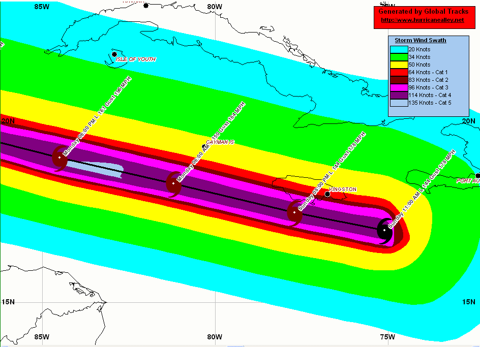
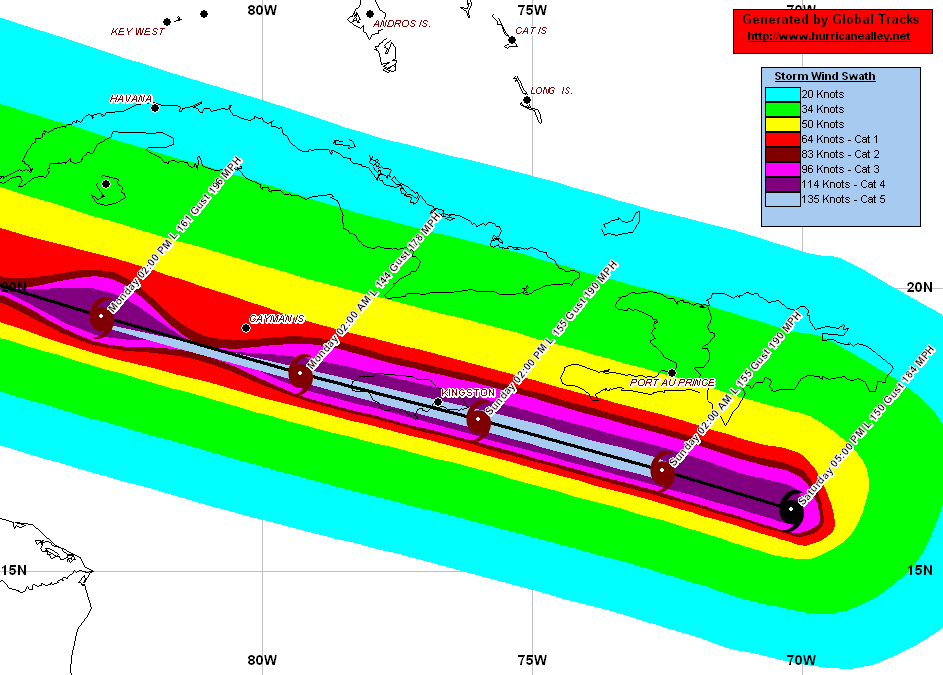
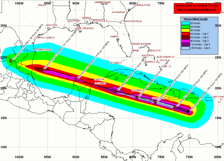
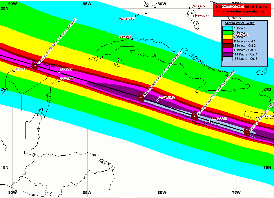
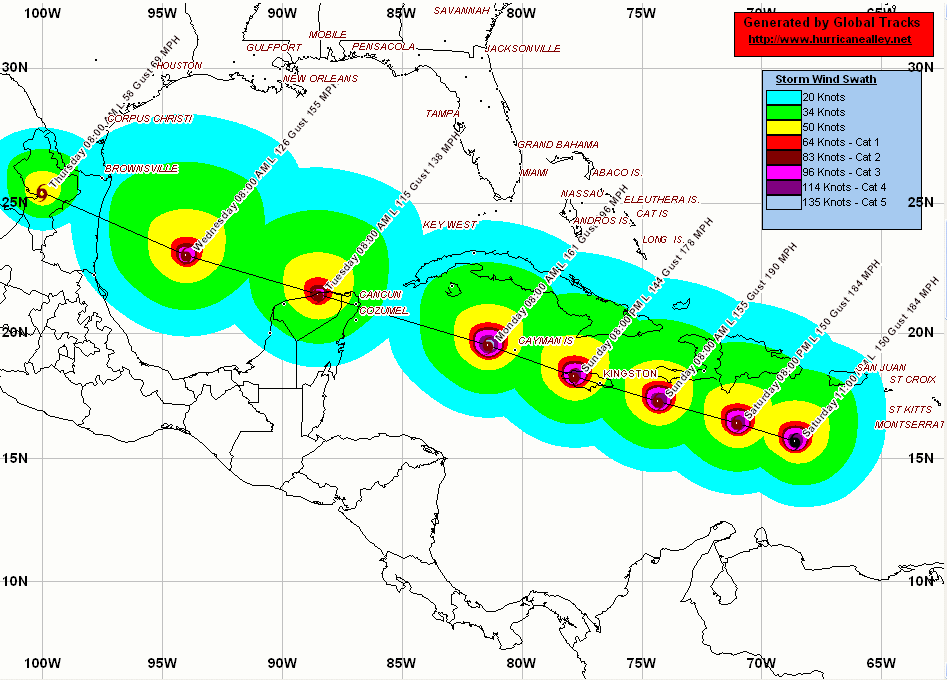
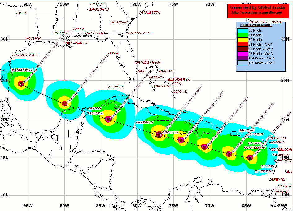
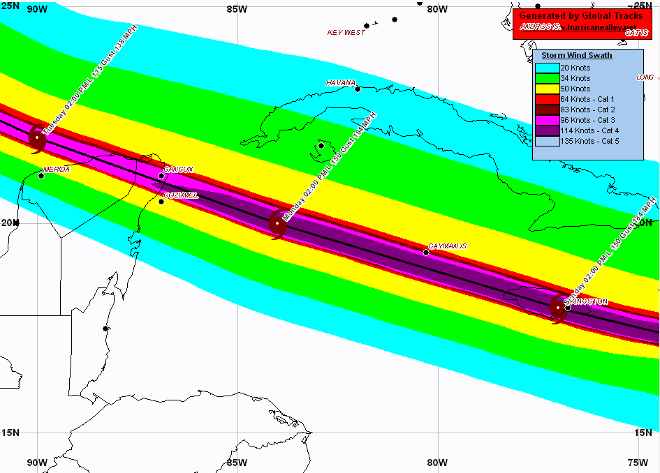
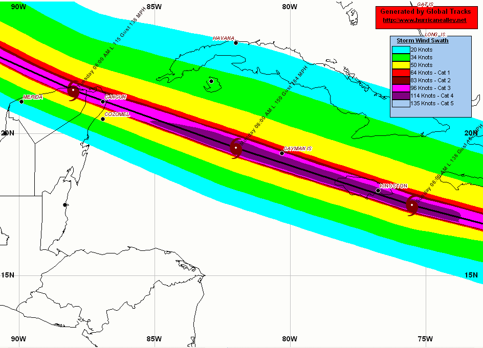
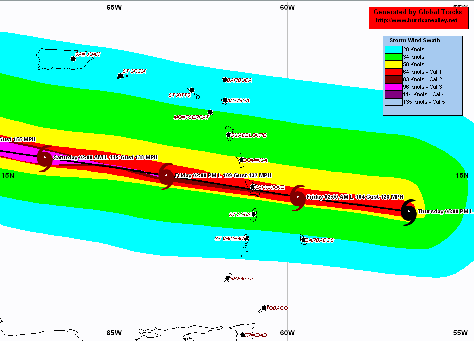
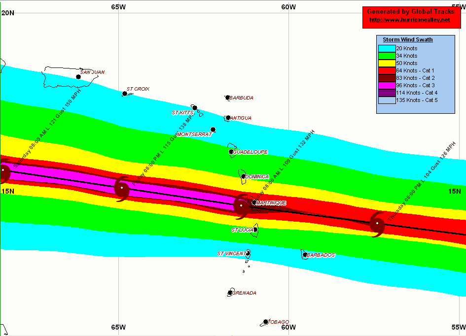
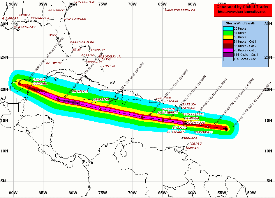
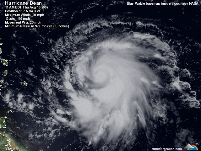

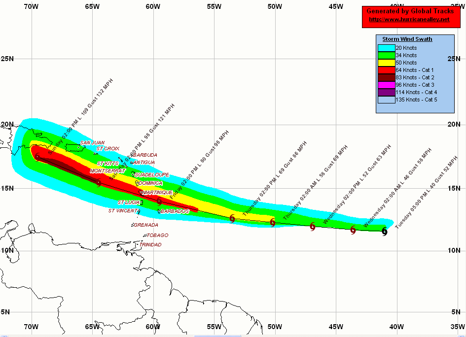
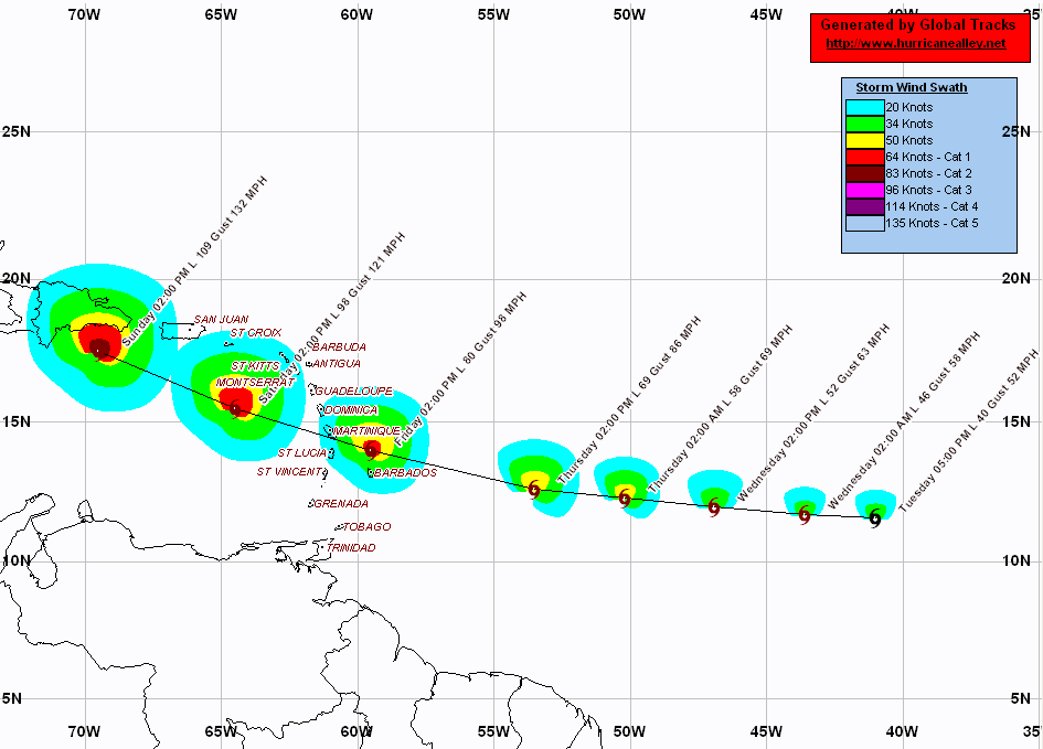
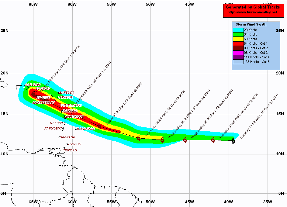
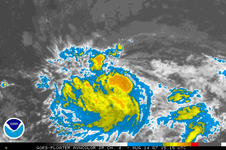
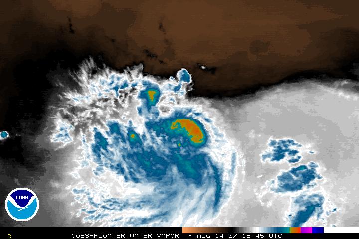

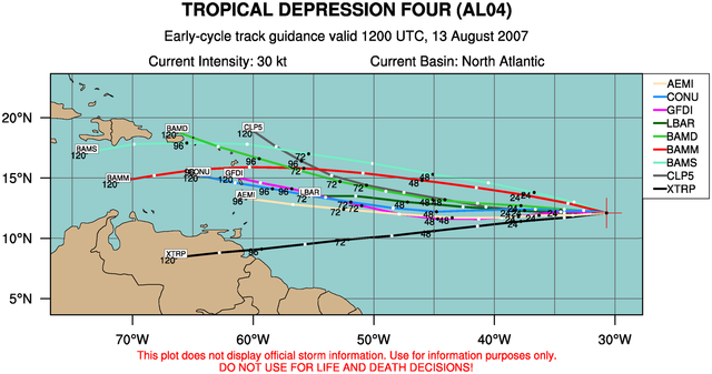
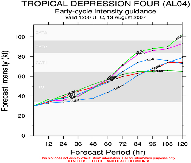
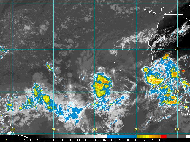
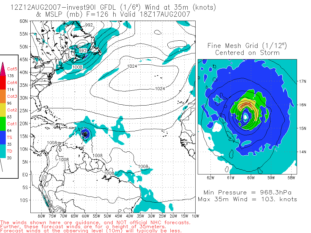
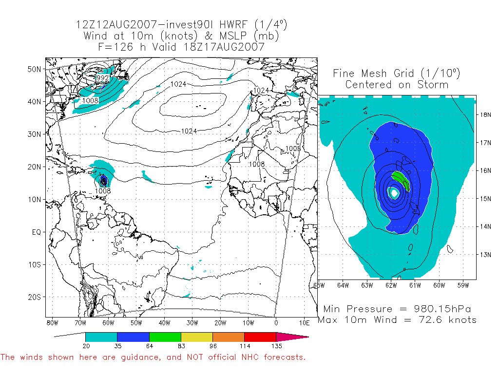
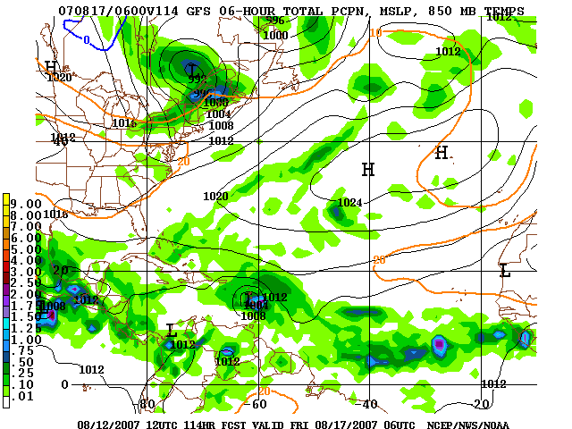
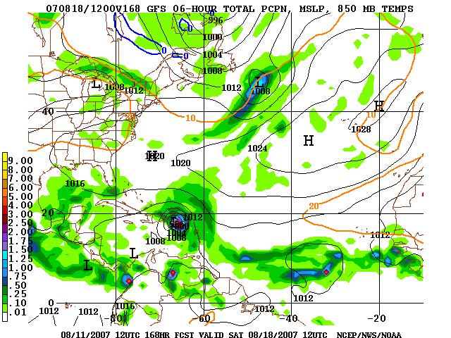
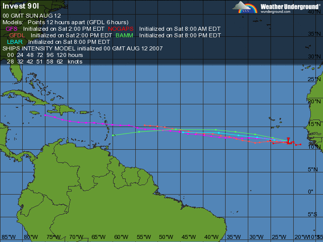
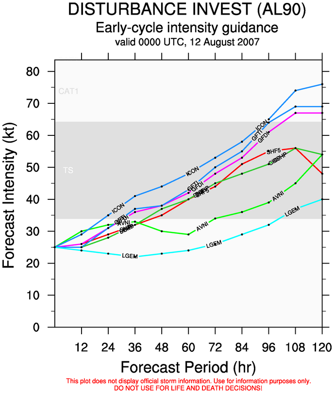
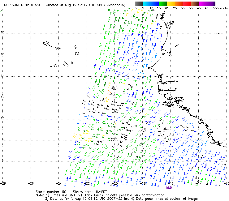
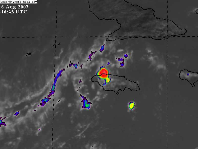

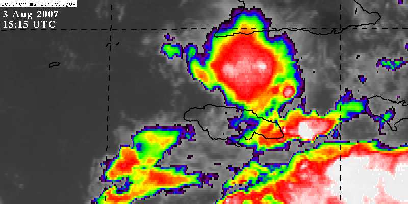
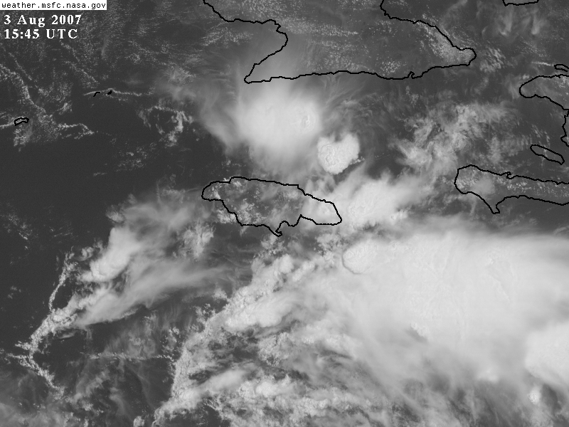
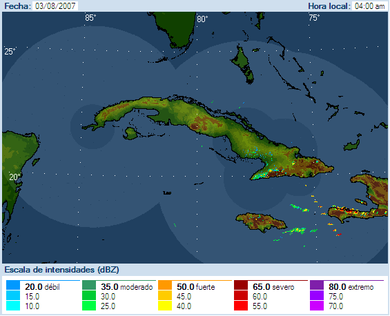
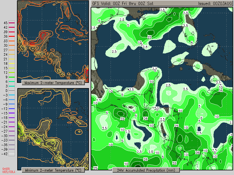