
|
For the most recent reports from St.Thomas see this page.
- - - 2009 Hurricane Season - - -
|
- Attack of the Flying Termites
|
- From: "Jane Higgins" <jhigginswear at islands.vi>
- Date: Sun, 6 Sep 2009 06:58:41 -0400
|
|
Last check on Storm Carib last
night our story was told by Crabby from St John
.
Good thing we cancelled the dinner on
the deck as the flying
termites were everywhere and we had to
close up and turn out all the lights. Some
vacuuming of the corpses and
then off to bed with cloud cover and
drizzle.
This morning very early a bit of
Tahitian blue sky was a colorful wake up
call,,along with
intermittent wide bands
of rouge and a faint rainbow, no wonder
Pissarro's use of
color manifested from his childhood memories in St
Thomas.
The radar is clear, we are in for some
sun and now back to plan A on the deck.
We have a farmer's market at Yacht
Haven Grande this morning, hoping to pick
up some cucumbers for
pickling.
Have a fabulous sunny day on the island
you call home. Visitors enjoy the unexpected luxury
of cooler temperatures and water
logged cisterns.
|
|
|
- West to East
|
- From: "Jane Higgins" <jhigginswear at islands.vi>
- Date: Sat, 5 Sep 2009 10:22:41 -0400
|
|
In the last half hour weather has
changed dramatically, definite movement of
West to East downpours and darkness,
the temps are still dropping, and the
plans are
cancelled.
Hoping that our neighbors in
Puerto Rico stay home , please don't try
to drive in this, flights are cancelled
as they should be. Do you remember
Hortense?
Let us know how you are doing in Puerto
Rico and Dominican Republic,
we feel like Erika is coming back and
stalling over us.
Stay dry, now hearing
thunder.
|
|
|
- Fireside Chat
|
- From: "Jane Higgins" <jhigginswear at islands.vi>
- Date: Sat, 5 Sep 2009 10:05:05 -0400
|
|
Good Morning
Islanders,
It is chilly enough to pull on
the pants and long sleeve t-shirts. We are so used to radiant
sunshine
most days of our lives that anytime we
get below 80 degrees winter psyche sets in. It is as
dark
as 7pm right now with low level
charcoal clouds moving back from west to east, and
dripping
rain.
We have a fire pit on the deck
and firewood drying out for tonight's dinner time.
There
is something special about the
reflection of the flames on the water and the fragrant
hickory
smoke that adds to social
ambiance. Grilling homegrown star fruit tastes like a
Granny
Smith pie , fall must be
here.
Erika's sunsets introduced some new
hues on the North side. A
particular turquoise fuchsia
combination last night was the moment
to make it all worth it. The clouds
piled in again last night burying the
moon and casting rouge all over the grey. Can someone
tell
me where the red tints come from on a
cloudy night? The Culebra picture shows that slice
of
multi color that I'm trying to
describe.
The poorest of the poor in Haiti may
once again have to face too much rain and mudslides.
Their
potable water issues are at a crisis
level, while the clean water from the sky can't be collected
in
systems they don't have, it is a cruel
problem, that we all need to focus on trying to fix.
Dear Haitians stay safe, and let us
know how we can help, again and again.
We have a good roof, we are the
lucky ones.
|
|
|
- Rain....
|
- From: ronusvi at aol.com
- Date: Sat, 05 Sep 2009 08:41:48 -0400
|
Rains have been coming and going. Looks like one of those rainy days. We need it. Thanks Erika!
Ronnie Lockhart
|
|
- About last night and try ISLAND BIRDS
|
- From: "Jane Higgins" <jhigginswear at islands.vi>
- Date: Fri, 4 Sep 2009 11:02:08 -0400
|
|
Good
Morning,
Around 11pm last night lightening started reflecting on the
North clouds from
the South.
The deck view straight
up exposed clouds piling in
huge puffs
crowding out the stars
and the full moon.
Around 2am the thunder came closer,
lightening increased into whole sky flashes and the
desperate
dogs tied up outside in the neighbors
yard whined pitifully. We unplugged the important stuff
ready
for booms over head, but the
thunder stayed distant. Then the rain started in such a weird
way;
like someone standing in the shower
turning it on full blast for 5 seconds, then turning it completely
off.
This went on and off till sleep moved
back in.
Today is steely , a cool break
from the intense heat of the last week. Now we've had enough
passing
showers and a bucket dumper that it is
time to hook up the hose to the auxiliary cistern and
download
into the underground tank. We are
so lucky to get the rain, we were close to buying
water again.
Why are the schools open today? I know
that the NHC warnings forced the government to close
schools
yesterday and nothing happened, but
can't the government look at the radar and the sky and figure
out
that the schools need to be closed
today? At least by noon, so the kids can get home before the
roads
pool up. You do have to wonder
who is in charge? We are hearing of rainy reports from all sides of
the
island. St. Croix is
getting it good now, so glad my friends there prepared.
In answer to the Vieques report,
another alternative for folks stuck with Cape Air down, is ISLAND
BIRDS,
www.islandbirds.com
,they may come
get you, they are an on-demand charter
company that flies to
all of our
islands
, BVI phone
is
284-495-2002 or
US toll free # is 877-515-5066, they tend
to bend over backwards
to
make sure they can get
you where you need to
go.
Rain is back here and the pool level
came up to where it should be. The sugar birds and hummingbirds
have emptied the feeders again, and the
parakeets are chattering in the genip trees. The critter noises
all
night were louder than usual, the tree
frogs, crickets, and crabs were in unison in their gratitude for
the
showers. It is dark enough now
that some of the night sounds are audible.
Stay in touch, let us know how it goes
today, every time we prepare we are that much closer to
being
ready for anything.
West End Fortuna, Rain Forest,
Facing the Atlantic, St Thomas, US VIRGIN
ISLANDS
|
|
|
- Oh well.
|
- From: ronusvi at aol.com
- Date: Thu, 03 Sep 2009 16:42:58 -0400
|
The forecast is weird. They are showing the depression almost past us and turning back to come by tonight! I don't think so. They did something similar with Omar last year. These guys need less coffee!
Ronnie Lockhart
|
|
- And so Erika begins...
|
- From: Max Henderly <max.henderly at glacialenergy.vi>
- Date: Thu, 3 Sep 2009 11:51:14 -0400
|
We had our first respectable band of wind, about 35 knots,
pass over the north side of St. Thomas. Out on Tropaco Point, we are catching
the full brunt of the ENE wind and rain as it passes over Magens Bay. We
have had regular bands of wind and light rain all morning. Nothing huge
yet, but it has begun.
Max Henderly
Tropaco Point - Estate Hull Bay
US Virgin Islands
|
|
|
- Still on track
|
- From: ronusvi at aol.com
- Date: Thu, 03 Sep 2009 11:00:37 -0400
|
Looks like Erika is determined to hit the VI. Dead on for STX right now. What's appealing is the it is only 40 mph.
Ronnie Lockhart
|
|
- A Little Rain and Wind
|
- From: "Jane Higgins" <jhigginswear at islands.vi>
- Date: Thu, 3 Sep 2009 09:19:19 -0400
|
|
Good
Morning,
It is a gray day on the North side of
Fortuna West End St Thomas, raining now and slight swirly
winds
are coming and going thru the tallest
trees. The dogs found the rugs and it seems so much
cooler
than it has been in the last few
days. The Atlantic is showing more chop and a few motor
yachts
made their run back to Puerto Rico
yesterday late afternoon.
Looking forward to getting some cistern
benefit out of Erika. I'm hoping that Steve from
Anguilla
can lets us know if our friends in
Welch's Village are getting some deposits in their bone
dry
cisterns?
Take care and stay tuned.....anything
moving this slowly bares watching. I hope the Puerto
Ricans
are paying
attention.
How does the sea look from the Mahogany
Run views? Let us know how it is in your
neighborhood.
|
|
|
- Good morning.
|
- From: ronusvi at aol.com
- Date: Thu, 03 Sep 2009 08:12:47 -0400
|
Time to see what's going on. Windy and light rain as I type. Looks like Erika has swayed a little back to the North. Feel for Puerto Rico as it seem it will cross diagonally across there. Here is a web cam in my window. Hopefully it will transmit as there is no need to shutter the house.
http://www.caribbean-on-line.com/caribbean-web-cams/charlotte-amalie-harbor.shtml
Ronnie Lockhart
|
|
- Southern Gal
|
- From: ronusvi at aol.com
- Date: Wed, 02 Sep 2009 23:03:29 -0400
|
I am happy to see that she is still swaying South! No difference is wind speed but going South! Good thing!
Ronnie Lockhart
|
|
- Further South.
|
- From: ronusvi at aol.com
- Date: Wed, 02 Sep 2009 19:37:37 -0400
|
Seems like I figured, she is moving more South. Unfortunately, we are now poised to get te Northern quadrant. Not too good, but she is still a baby!
Ronnie Lockhart
|
|
- Erika again!
|
- From: ronusvi at aol.com
- Date: Wed, 02 Sep 2009 12:38:22 -0400
|
The buzz is around since the 11 o'clock report that she will pass right between STT and STX. Trouble is she has been dropping lower every few hours. So, to me it's a wait and see what she does next.
Ronnie
|
|
- Confused by Computer Models?
|
- From: "Jane Higgins" <jhigginswear at islands.vi>
- Date: Wed, 2 Sep 2009 09:17:25 -0400
|
|
Like Dave said sometimes the computer models can't
nail it. Take a look outside now and report back to us.
Yesterday it was roasting, then last night
the temps dropped, and now we have breezes off
and on, the
Caribbean sea was slick and flat yesterday and
today the Atlantic side is getting
choppy. Erika's 4-8mph forward
speed is freaky. The tops of the trees are
moving more than they should on a normal
September day. Remember
how slow Lenny was? Maybe the water trucks will be resting soon.
What were the predictors before
computers?
|
|
|
- Erika revisited
|
- From: ronusvi at aol.com
- Date: Wed, 02 Sep 2009 06:24:11 -0400
|
Seems like she took a dip last night and will pass closer to us than I thought. Will wait and see what the next report has to offer.
Ronnie Lockhart
|
|
- Ericka
|
- From: ronusvi at aol.com
- Date: Tue, 01 Sep 2009 18:10:07 -0400
|
Okay, time to get looking! As usual, she should pass North! Keeping fingers crossed.
Ronnie Lockhart
|
|
- Invest 94L (September 1, 2009)
|
- From: "Cordelia L. Jones" <cordelia at vilaw.com>
- Date: Tue, 1 Sep 2009 10:09:59 -0400
|
|
Good
Morning,
It seems Invest 94
is still somewhat disorganized, but producing moderate to strong thunderstorms
and strong convection is within a 60 NM radius of 16.5N 53.5W. This is a
very large, broad Tropical Wave and although she is having a hard time becoming
organized enough to be considered a Tropical Storm, she has all the right
elements to do so. The sea surface temperatures are at approximately 29
Celsius, there is very little wind shear and the Saharan Dust Layer is still
nonexistent. Also, she has slowed down from moving 15 mph to 10-12 mph,
which should allow for further intensification.
At present, Invest
94 is 15.9N 56W or 240 NM East of the Leeward Islands and approximately 632
miles East of San Juan. Strongest gale force winds extend to the East of
the center and it is 1006 mb. As usual while a tropical system is still a
wave, the computer models will be a guess I think at best. NGAPS has
Invest 94 at 18.0N 60.3W on Wednesday at 6:00 am with winds at 33 mph.
LBAR has it at 18.2N 63W on Thursday at 6:00 am, but has not given a wind
speed. BAMM model has it at 17.8N 64.5W on Friday morning, but does not
give a wind speed. Other computer models, such as the GFS, CMC have
Invest 94's track a little North of us here in in the U.S. Virgin Islands and
Puerto Rico. I tend to prefer the Navy NRL Monterey track which has Invest
94 heading directly towards Barbuda, and after that it becomes unclear if will
move slightly North of us or directly over us here in the Virgin Islands.
As we started
receiving Hurricane/Tropical Storm Preparedness Statements issued by the NWS in
San Juan as early as yesterday, for the U.S. Virgin Islands, British Virgin
Islands and Puerto Rico, it would be a good idea for us to keep a close watch
and monitor this system very closely. Also, the NWS in San Juan has the
wind speed at 35 mph.
Cordelia L. Jones, St. Thomas, U.S. Virgin
Islands
..
|
|
- Invest 94 Correction: (August 31, 2009 at 10:04 am (AST)
|
- From: "Cordelia L. Jones" <cordelia at vilaw.com>
- Date: Mon, 31 Aug 2009 10:07:45 -0400
|
Good Morning.
I am re-posting my original earlier post, because I
needed to make a correction in my wording. Therefore, here is my corrected
version:
Invest 94,
which is approximately 600 miles East of the Lesser Antilles, appears to be better organized this morning and seems
to have Tropical Depression qualities to it. Also, conditions are
very favorable for further intensification, such as it is in a warmer sea
surface temperature, very moist air and the Saharan Dust is minimal if any
within the coordinates of Invest 94, which the center at present is 13N
50W. Winds are at approximately 30 mph, 1007 mb. It is moving
West-Northwest at 15 mph. The slow forward movement of Invest 94, will
only enhance its strengthening. This
morning's computer models, such as NGAPS, LBAR and BAMM have Invest
94 moving extremely close to us if not directly over us. Whereas, the GFS and CMC models
have it moving almost similar to Hurricane Bill's path moving to the
Northeast of us here in St. Thomas. I think until the Invest becomes at
least a tropical depression, it is hard to give the computer models much
validity, because much can change from a tropical wave to a tropical
depression. I do feel though, Invest 94 will strengthen into a tropical
depression by this afternoon and could turn into a tropical storm by tomorrow
late afternoon or early evening. Regardless, we here in St. Thomas, should
keep a very close watch on Invest 94 because it will strengthen further and it
is, I believe headed for the Virgin Islands or maybe a little to our
South.
Cordelia L.
Jones
Email: at vilaw.com
href="blocked::mailto:cjones at vilaw.com">cjones at vilaw.com
|
|
- Invest 94 (August 31, 2009)
|
- From: "Cordelia L. Jones" <cordelia at vilaw.com>
- Date: Mon, 31 Aug 2009 10:01:33 -0400
|
|
Good Morning.
Invest 94, which is
approximately 600 miles East of the Lesser Antilles, appears to be better organized
this morning and seems to have Tropical Depression qualities to
it. Also, conditions are very favorable for further intensification,
such as it is in a warmer sea surface temperature, very moist air and the
Saharan Dust is minimal if any within the coordinates of Invest 94, which the
center at present is 13N 50W. Winds are at approximately 30 mph, 1007
mb. It is moving West-Northwest at 15 mph. The slow forward movement
of Invest 94, will only enhance its strengthening. The computer models,
such as NGAPS, LBAR and BAMM have Invest 94 moving extremely close to us if not
directly over us this morning. Whereas, the GFS and CMC models have it
moving almost similar to Hurricane Bill's path moving to the Northeast of
us here in St. Thomas. I think until the Invest becomes at least a
tropical depression, it is hard to give the computer models much validity,
because much can change from a tropical wave to a tropical depression. I
do feel though, Invest 94 will strengthen into a tropical depression by this
afternoon and could turn into a tropical storm by tomorrow late afternoon or
early evening. Regardless, we here in St. Thomas, should keep a very close
watch on Invest 94 because it will strengthen further and it is, I believe
headed for the Virgin Islands or maybe a little to our South.
Cordelia L.
Jones
Email: cjones at vilaw.com
|
|
- Hi
|
- From: ronusvi at aol.com
- Date: Sun, 30 Aug 2009 09:03:55 -0400
|
Well. we are almost through with August. The dreaded September arrives. A little something out there now but it too looks like it will head North if anything develops.
Ronnie Lockhart
|
|
- LOOK EAST
|
- From: "Jane Higgins" <jhigginswear at islands.vi>
- Date: Fri, 28 Aug 2009 10:32:13 -0400
|
|
Good thing we had Bill as practice.
When Dave says it could be BAD....he means it, Dave is always
right,
and my aviator husband pointed out this
thing to the East of us yesterday, basically saying that we'll
be
busy towards the end of next week. A
question for Dave and Gert.......Sept 4 is the full moon, do you
believe the moon phase influences a pending
storm?
page today and we may be gaining some hope
that the clear azure waters of Lindbergh Bay may be saved
if our Governor listens to our pleas.
With no Sahara Dust we are shocked
again by the clear beauty of this place, rest up this weekend, we
will probably
be very busy soon
come.
|
|
|
- another iguana story
|
- From: "Jane Higgins" <jhigginswear at islands.vi>
- Date: Tue, 25 Aug 2009 10:31:04 -0400
|
I received this charming picture and story from another St. Thomian...
It was cool this morning and we've had some rain overnight, still could use
more but I think there may be something brewing north of us. Ready for
winter wind now by 9am it is sweaty time.    Jane
From Debbie, this text goes with the picture>
caught this little guy whirling around in the pool filter...thought it
was a twig stuck in there...didn't take him indoors, released him
after a photo session poolside. What a beautiful color he was and
very tiny! ....we live at Mahogany
Run on St. Thomas, North side of the mountain facing the BVI's.
Debbie
Jane Higgins
jhigginswear at islands.vi
Fortuna, West End, St Thomas
|
|
- Invest 92L
|
- From: "Cordelia L. Jones" <cordelia at vilaw.com>
- Date: Mon, 24 Aug 2009 16:03:20 -0400
|
|
We now have Invest
92L approximately 180 miles East of the Northern Leeward Islands. Last I
saw it is moving West at about 20 mph and at that speed, if it continues on its
path, we in St. Thomas, U.S. Virgin Islands will be experiencing some gusty
winds and hopefully more rain later this evening. Per the NHC/NOAA this
Tropical Wave went from its color classification of yellow this morning to
orange on its 2:00 pm update. So, Invest 92L has from 30-50% chance of
developing into something stronger. However, due to its close proximity to
us here in St. Thomas, even if this Wave develops into a tropical cyclone, it
will be past us and probably Northwest of us. It has become extremely
cloudy here and the winds have started to pick up, but I cannot tell if this is
from Invest 92L or typical Island weather.
Cordelia
Jones
St. Thomas, US Virgin
Islands
|
|
- iguana in the couch?
|
- From: "Jane Higgins" <jhigginswear at islands.vi>
- Date: Mon, 24 Aug 2009 14:52:17 -0400
|
|
Our island life is never really
dull......just spaced out moments of high excitement diluted by
tropical
heat and hurricane scares. Some of us
live in open houses; where our doors fold back during the
day and we let the outside in, along with
that comes critter guests that may not be able to figure
out
how to get back
outside.
I just lost a lime green baby iguana in my
couch. The cats are in trouble with me now for watching too
close while I try to rescue the poor guy. The color of a baby iguana
is impossible to describe...neon lime with
highlights of neon yellow with little red
dots here and there might be close.
Meanwhile it is humid with some breeze and
we had good rain last night. Pressure washing mania
over the weekend put a big dent in the
cistern , hoping for more rain soon.
Anybody else have an inside the house iguana
story?
|
|
|
- Cooler, breezier turtle hathing time
|
- From: "Jane Higgins" <jhigginswear at islands.vi>
- Date: Sun, 23 Aug 2009 10:33:04 -0400
|
|
We have had cool breezes and it
feels like winter winds compared to the hot still
sweaty time we had after Bill's
passing. Life seems more focused and easy
when you know you've been by passed by a
Cat4 bomb.
Now we anxiously await the turtle hatchings
about to commence on St Thomas. We had a
monumental event in July when two
leaherback turtle moms came to nest on our Brewer's
beach and Lindbergh Bay beach. We'll
be assisting in hatching watches soon, involves
lots of quiet hours on the beach at
night with no lights. It is the time to be
grateful
that these huge ancient ocean friends have
decided to entrust us with their precious nests.
We continue to try to stop our government
from dumping mercury laden toxins in our clear
next weekend the few environmentally
friendly Senators join our island divers to take undersea
images of the area where the government
proposes dumping the poisons. Join us on Saturday
August 29 from 9am - 12 noon and dive
in Lindbergh Bay.
We can't control the weather, we can be
ready for it. We can try our hardest to save these
fantastic
islands we call home, the land, flora,
fauna and sea life are ours to ruin or embrace for our
grandchildren's grandchildren. When
the developers figure out that stopping development now
will make them richer down the road we may
be able to save paradise. Too bad that riches
are measured in cement on too many
islands.
We just picked very ripe star fruit and the
limes are falling off the trees so I'm going to make
star fruit/lime crisp for the beach party
today.
Assuming Bill is freezing by now way up
north. So happy that Bermuda came thru it all with
little damage. What a glorious day
today will be on that island.
|
|
|
- A Special GRRR for Bermuda August 20, 2009 1900Z
|
- From: "Jane Higgins" <jhigginswear at islands.vi>
- Date: Thu, 20 Aug 2009 16:50:00 -0400
|
|
I received this just now and I think you folks in
Bermuda should read this...
Sent: Thursday, August 20, 2009 4:31 PM
Subject: A Special GRRR for Bermuda August 20, 2009
1900Z
I do not wish to alarm my friends on the rock but, I
do wish to raise the red flag of warning!
Unfortunately or maybe not, I have sat through over a
dozen hurricanes, none alike! I am intimately aware of "IKE" and
Galveston, TX. (Family) IKE was the largest hurricane in
recorded history being 600x240 miles:
When IKE crashed into Galveston Island, head on, it
was a CAT-2 hurricane! " Ike also had the highest Integrated
Kinetic Energy (IKE) of any Atlantic storm. IKE is a measure of storm surge
destructive potential, similar to the Saffir-Simpson
Hurricane Scale, though it is more complex and in many ways more accurate.
On a scale that ranges from 1 to 6, with 6 being highest destructive potential,
Ike earned a 5.6."
Though for the most part I concern myself with the
mariners and the aviation community, over the years I have gained e-pals all
over the Atlantic and I care about all of you. Bermuda, "the rock"
is no exception.
For those of you that are familiar, this will be a
refresher, for newbies, learn!
When a hurricane is pushing ahead, the leading edge I
refer to as the bumper. It simply pushes anything in front of it
straight ahead including water, winds, surge and incredibly bad storms
containing tornados. If you were in the drivers seat of the
hurricane, let's say Bill and here you are tooling across the ocean. As
you look out to the right side you see the churning turning coming across in
front of you from right to left. As you look off the left side you see
everything going away behind you. It is the counter clockwise spin
of the storm.
Within 25 miles of the eye of a hurricane it really
doesn't matter much which side you are on, you will get the brunt of the
"everything" that is contained in a hurricane at it's worst depending only
upon category! In the graphic of Bill below, Bill is pretty much
contained within a Lat Long box and direction is from lower right to upper left
and you will notice that the right side has a much larger
storm/wind area. This is commonly referred to as the WRONG side
as it is much stronger and lasts lots longer and it is this side that is pushing
water out front of it. In Bill's case, lots of water
with wave heights 35 to 50+ feet in front of the approaching eye.
Just so you fully appreciate what is quickly
approaching so that you may be prepared depending on which side of the island
Bill passes on? I am going to show you some real brief
examples.
First, Cayman Brac took a direct hit by Paloma last
year, a CAT 4 hurricane! No one will really either appreciate
or understand why at the time I said though it was terrible, they were
lucky! Why did I say that? Here is a photo of Cayman
Brac:
Wow, pretty torn up and I think well over a thousand
were without homes for some time.
Now lets look at Galveston Island, IKE:
CAT-2
Galveston also took a direct hit with a 14 foot storm
surge that topped their 14 foot sea wall to prevent flooding and
damage.
20 miles inland on Galveston Bay is
Seabrook:
One of many high n dry's in Seabrook: note the
standing water.
25 miles to the northeast of Galveston is Gilchrist,
use the link below to see the relationship between the
two.
Gilchrist was on the right (WRONG) side of IKE, and
only 25 miles away. See Gilchrist photo below: Before IKE, this was solid
houses!
Further to the northeast into Louisiana storm surge of
25+ feet went 15 miles inland.
To best understand preparations you need to know which
side of the storm you are going to be struck by, direct, left, or right
(WRONG). At that point it is all about winds, from which direction,
then comes or doesn't come, the water!
If I remember correctly Bermuda is approximately 22
sq. miles and the highest point is Town Hill at about 250 feet. I
guess the rest is about 16 feet on average? The rock is really a
composite of over 180 coral islands or islets.
There just aren't a lot of places to hide if one
really had to.
Currently, Bill, CAT 3-5, is expected to
pass at some distance to the west of Bermuda, the further west the better as the
islands will be on the wrong side if this is the case!
Depending on distance away, waves from 10 to 30 may be expected.
Winds? I don't know yet but breezy!!!!! (We will all know tomorrow!)
Storm surge, might be slight, 5-10 feet? If Bill is near by, 10 feet
and up, way up if Bill is within 50 miles! GRRR
If, and that is a damn big if, Bill makes a head on direct
hit on the islands, waves to 30 feet and surge to at least 25, winds to 150
mph. This is assuming nothing knocks it out! Doubtful
...
There is absolutely no reason to throw sugar over a very dangerous
storm! NONE. We have all seen these things turn on a dime, so to
speak.
We have models and forecasts and wave guides all based on pertinent
data and guess work. Can we trust this information? As a
rule yes but. In the final analysis, we are not in
control. It's that simple, we prepare for what we expect based on
the best information at the time. I would just like you to expect
the unexpected and understand what MIGHT happen with just minor
variables. Now you got it, it's in your hands. God Bless
you all and good luck.
Always keep an eye to weather and be safe out there.
Max
The usual pics and links below:
Make the best of today, tomorrow is not promised ....
|
|
|
- Dear Susan in Bermuda
|
- From: "Jane Higgins" <jhigginswear at islands.vi>
- Date: Thu, 20 Aug 2009 11:22:41 -0400
|
|
Ignore the chiding, it does seem to be
an island dwellers game...you be ready for a Cat 4
and you will rest easier, you are
obligated to protect your family first. I think the
swells
will rise and be a problem for
lowlanders . Just be ready and don't worry about what
others
think of rational
caution.
|
|
|
- Relief at Last
|
- From: "Jane Higgins" <jhigginswear at islands.vi>
- Date: Thu, 20 Aug 2009 10:27:01 -0400
|
|
We are so glad to see Bill go north.
Last night was the hottest night I've ever been thru in the 16 yrs I've lived
here.
The fan was full blast at my feet and
it seemed like the air was thin. The wind was at a complete
standstill,
now we have a little bit of a normal
breeze going. The sea has calmed down on the north side and it just
looks
like another great day in paradise.
After the adrenalin push yesterday, the
home front has that fantastic minimalist look , the naked decks and
courtyard
are now screaming for pressure washing
of course! This truly is our spring cleaning time of year and now
we
are completely prepared for the rest of
storm season thru November.
We were very lucky this time and just
hope that Bill does no harm to anyone. What a
relief.
|
|
|
- Surfs up
|
- From: "Jane Higgins" <jhigginswear at islands.vi>
- Date: Wed, 19 Aug 2009 13:03:03 -0400
|
|
We are about 650 feet up the hill above northwest
side of St Thomas in Fortuna facing the Atlantic and islands
called Cockroach and Cricket. The seas are
building, and looking confused, I'd guess over 6ft, lots of white
caps
and chop, surfs up on the little outer islands
splashing over them, could be high tide. Good steady wind
now which will keep us cooler as we finish
up.
I just heard the CNN weather guy say "gee I hope
Bill turns right soon", that must make some feel really secure!
Forecasting is guessing with lots of computers to
back you up.
|
|
|
- Bill is too much in my space
|
- From: "Jane Higgins" <jhigginswear at islands.vi>
- Date: Wed, 19 Aug 2009 04:54:44 -0400
|
|
Good Morning,
I've been up since 3am ,watching Bill creep
into our neighborhood and local radar field, he is just too
close
for me. I'm sure Bill will go north of us , but he is so huge and his
tail seems to go almost to S. America,
so I'm cancelling my travels and going
into full prep mode. I may be overly cautious but I've been
thru
too many hurricanes.
I'd much rather have our perimeters
checked and re-checked and nothing happen than the
alternative.
Take extra caution in Bermuda
please.
Let us know if you are feeling
any vibes from Bill.
|
|
|
- Wednesday at 5:30 a.m. I'll need your advice
|
- From: "Jane Higgins" <jhigginswear at islands.vi>
- Date: Tue, 18 Aug 2009 21:01:09 -0400
|
|
I have to be at the airport at 6:30 a.m. Wednesday
to fly to Orlando. I still
see outer bands and a big huge storm that
could impact us here on the
northwest side of St Thomas. I am not seeing
the right turn and move north
that others may see, so please check in and let me know...do I fly away from my
husband, dogs,
cats, and home and or do I go?
This is the issue with island dwellers, as much as
we hate storms,
we can't imagine leaving our homes behind and not
being there to help make
sure all is taken care of. I'll
check in again at 5:30 a.m. and make my decision then.
All of your advice will help, the trip to Orlando
is just business. I feel horrible for
anyone in Bill's path, he looks like a big strong
brut with a confused path.
Stay safe and be ready. If I lived in Bermuda
and I could board up my house and
fly away I would for sure. If you have
not been thru a hurricane don't make any
assumptions, the storm is one thing, the aftermath is the pits.
Dave, I hope you read this and can advise.
|
|
|
- Tell Me Again about Bill Turning Right?
|
- From: "Jane Higgins" <jhigginswear at islands.vi>
- Date: Tue, 18 Aug 2009 17:24:25 -0400
|
|
I'm still
waiting to see the big turn right???
|
|
|
- More stuff.
|
- From: ronusvi <ronusvi at aol.com>
- Date: Mon, 17 Aug 2009 22:37:54 -0400
|
|
Ana gone, Bill fleeing. Now we can hopefully relax for a while or longer!
Ronnie Lockhart
|
|
|
- Ana Was up Early
|
- From: "Jane Higgins" <jhigginswear at islands.vi>
- Date: Mon, 17 Aug 2009 10:16:38 -0400
|
|
Good Morning,
Ana rattled and boomed around around 4:30
this morning, enough to make me hop out of bed and
clear a few things off the deck that I
should have taken care of yesterday. She brought some
rain
from different directions and enough
thunder to scare the dogs. The Atlantic is steely and choppy
with
some building seas and the sky is a perfect
match. All is calm with a gust or two. Most models show
Bill
tracking North and he is moving fast.
If he doesn't track North I don't want to be in his
path. My
trip to Orlando on Wednesday a.m. will be
confirmed around 5 a.m., hoping the models are right.
We did need that rain and hoping some of it
landed in the cistern. The power wash to the windows
was welcome.
Take care and let us know how you are doing
in Puerto Rico?
Oh ...there is another blast of circular
wind, those gusts between calm air are memory triggers
that
is for sure!
Did you get any rain in Anguilla?
|
|
|
- Things
|
- From: ronusvi <ronusvi at aol.com>
- Date: Mon, 17 Aug 2009 08:11:49 -0400
|
|
Well, yesterday was a scorcher at the Chili Cook Off. Today now, has been windy and rainy as Ana was downgraded. She's traveling fast, so I hope this will pass soon! Bill is now a hurricane, but does not appear to be coming anywhere close. Maybe some more rain.
Ronnie Lockhart
|
|
|
- Ana and Bill
|
- From: ronusvi <ronusvi at aol.com>
- Date: Sat, 15 Aug 2009 20:25:32 -0400
|
|
So far it looks like she will pass south and he north! Guess he does not like her like Luis and Marilyn!
Ronnie Lockhart
|
|
|
- Focus on Preparation
|
- From: "Jane Higgins" <jhigginswear at islands.vi>
- Date: Sat, 15 Aug 2009 10:16:45 -0400
|
|
Good Morning Island
Neighbors,
Think of storm preparation like spring
cleaning and it just becomes another annual chore that has
to be done. Ana will probably bring
some much needed rain especially for our friends in
Welch's
Village, Anguilla and cause more problems
Northwest of us as I travel to Orlando on Wednesday.
It is the possibility of Bill that is a
tough call now, too early to tell, and the thought of being away
from home when a storm might hit is worse than being in the path. It takes allot of
work to clear
the decks and take care of
the home front while my aviator
husband stays at the airport till the
last minute to make sure the aircraft
are gone or secure. So,
just to make things easier all around,
the deck clearing and spring cleaning
will commence earlier than
usual.
We are all stocked up and will top off some
empty bleach bottles with water if need be. We were in
the
market for a new generator anyway, and
today is delivery day.
Our pool pump is run by solar panels and
taking them down is the last task only when we are sure of
a direct hit, having a coconut smash the
solar panels would not be pleasant.
We are feeling some wind pick up now and
much clearer skies today, the Sahara dust is not lingering
to protect us, think of how great the
environment is now; very warm seas, low dust and the
time
of year to be ready. The
Atlantic has normal chop today.
Making sure all the laundry is caught up
and that the propane tank is full always makes me feel
better about living without power if need
be. Checking the flashlights and getting some extra
trash
bags is also part of the drill.
I've had some inquiries from some folks
that are coming down here this week, and all I can advise
is
that you call your airline and ask what
their policy is about changing tickets when a "named"
storm
is headed towards your destination. I
don't think we'll have any serious issues with Ana but
your
vacation may just not be great as we are in
storm season from August till end of October, so please
plan your trips around that. I do
think we all need to pay extra attention to what "Bill" might
become
and Storm Carib certainly is the tool to
use for making decisions about travel and preparation.
Tomorrow is our annual Texas Society Chili
Cook Off, great fun and food for worthy causes on our
Brewers Beach near the University of the
Virgin Islands, we are looking forward to raising
awareness
that are currently incubating in St.
Thomas.
Take care and STAY IN TOUCH, we need to
know what is happening in the other islands.
|
|
|
- Ana
|
- From: ronusvi <ronusvi at aol.com>
- Date: Sat, 15 Aug 2009 06:35:40 -0400
|
|
Does not look too god this morning. Hopefully our luck will hold and she will turn to the North!
Ronnie Lockhart
|
|
|
- HEADS UP, AUGUST MAP LOOKS LIKE SEPTEMBER NOW
|
- From: "Jane Higgins" <jhigginswear at islands.vi>
- Date: Wed, 12 Aug 2009 08:51:16 -0400
|
|
Good Morning Island
Neighbors,
This August map tracking from Africa is
starting to look a little like mid -September and you
know
what that means. PAY ATTENTION to
the lower circulation coming off of Africa and look at
your
preparedness list again. Just
cleaning up around the house and decks is a good idea
and
have a few extra supplies on hand
during this time of year.
The weather gurus have predicted a less
than normal season but the map looks more serious
now.
Being ready just helps getting thru
storm season so much easier. Looks like the cisterns will
get
some topping off
soon.
Help stop our government from dumping
harbor dredge spoils in Lindbergh Bay.
know that polluting a crystal clear bay
makes no sense.
Warm humid regards and get well wishes
to Ms Mermaid
|
|
|
- TD2 redux
|
- From: ronusvi <ronusvi at aol.com>
- Date: Tue, 11 Aug 2009 19:34:56 -0400
|
|
So, it looks like it will go north. No need to worry!!! Great!
|
|
|
- TD 2
|
- From: ronusvi <ronusvi at aol.com>
- Date: Tue, 11 Aug 2009 09:19:51 -0400
|
|
Got to keep an eye on this one. So far it's looks like it's coming straight here, but we know better!
Ronnie Lockhart
|
|
|
- Puerto Rico is Getting It Now
|
- From: "Jane Higgins" <jhigginswear at islands.vi>
- Date: Tue, 21 Jul 2009 16:17:04 -0700
|
|
My aviator husband just called and said that
flights out of Puerto Rico are being cancelled left and right now,
even
some powerful private jets are staying grounded at
this point, better safe than in the drink!
We had a major blast of some kind of band of
moisture that came in sideways and big drops around 2pm, I was at the
beach
enjoying the view and then the view was gone in a
minute, this came very fast and brought sogginess and now
very dull gray skies.
Mother Nature's way of warning us over and over
again to be ready.
Stay in touch islanders and let us know how you are
doing in Puerto Rico tonight. Take care and be safe.
Please visit our site and help us save the
leatherback turtle nesting site in St. Thomas, please forward
it on ,
thanks
St. Thomas, US Virgin
Islands
340-774-7071
|
|
|
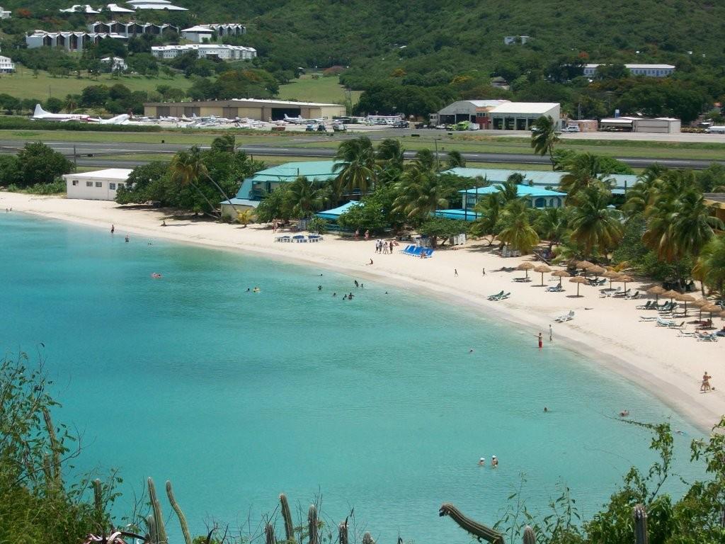
- RAIN AND NESTING! Leatherback Turtle Checks in to Virgin Islands Resort - NatGeo News Watch
|
- From: "Jane Higgins" <jhigginswear at islands.vi>
- Date: Mon, 20 Jul 2009 11:02:54 -0700
|
|
Good Morning Islanders, PLEASE
FORWARD THESE LINKS AND MESSAGE TO ALL YOU KNOW AND ASK
THEM TO FORWARD TO ANY INTERNET SOURCES
THEY USE TO SPREAD THE NEWS TO SAVE THE
LEATHERBACK TURTLES AND KEEP THE SEAS
CLEAN
We are watching the dust move out and have
had plenty of rain in the last few days to make the tomatoes really
happy.
It appears we should all be ready to expect
more rain from this system coming up the island chain and we
need
to CHECK OUT the Storm Carib site
more often now. The sea is warm enough and the dust is light enough
to
create problems
so we are thankful
for the winds that
sheer.
I am attaching an overhead picture of one
of my favorite "Sunday swimming beaches" a beautiful
beach
called Lindbergh Bay, this is a south
facing beach near the airport as
you can see. We had exciting news last week
when a huge leatherback turtle Mom came to
lay her eggs and nest on this
beach for the first time in many years.
Near the center of the photo you see some
lounge chairs propped in a circle around the nest. The hotel security guards and
other volunteers are watching over this
nest 24-7 and our community is looking forward to new baby turtles
soon.
Recently this
beach has been in the news
as some proposed dredging spoils from our harbor may end up being dumped
here.
We are all very
concerned and are working hard
to stop this action. A brilliant SOLUTION to the dumping was proposed by
our Senator James
to turn the dredging spoils into
a road bed material, as we all
know how our roads need improving here.
We know that
no one would want to spoil these
azure waters, we just need to work harder on making sure the best SOLUTION
allows for
re-using the spoils rather
than dumping them into the clear blue sea.
Please check out the NATIONAL GEOGRAPHIC
web story below about our turtles and the proposed
dumping,
Please visit our site
to see how you can get involved
in protecting our leatherback turtles and the Caribbean
sea.
WE NOW HAVE 40 DAYS TO APPEAL the proposal
to dump in Lindbergh Bay. Please email any leads, email
addresses
of ocean watchdog groups, ideas to stop the
dumping, and please FORWARD THIS MESSAGE TO EVERYONE IN
YOUR
ADDRESS BOOK that cares about keeping the
sea clean for all of us and supporting turtle nesting sites all over the
Caribbean.
Thanks so much for your efforts, looking
forward to your replies.
Jane Higgins
in Sunny St Thomas US Virgin
Islands
|
Attachment:
Turtles 033.jpg
Description: JPEG image
|
|
- Rain Just in Time
|
- From: "Jane Higgins" <jhigginswear at islands.vi>
- Date: Mon, 13 Jul 2009 08:56:15 -0700
|
|
Good Morning to blue skies and a soft gentle
rain, just in time for our tomatoes and peppers that have
been
too dry lately. We saw clearer skies over
the weekend; with some dissipation of African dust, the map seems
to
forecast more coming later on in the
week. The wild parakeets were picking at our genip tree this morning ; it
is
loaded with bundles of the sweet tart fruits
now. Every drop of rain sounds like money in the bank or
cash
in the cisterns. The green planet movement
has been focusing on bringing back rain barrels for gardens
stateside,
looks like we islanders are way ahead of
that retro-movement.
The sea appears to be upwards of 85 degrees now
around us, we need to look daily at how we can be
ready
for any storms that may come our
way. Constant clearing of loose items around the house and deck perimeters
is
on the to do list now.
Our coconut man showed up yesterday with
his 5 kids in tow to do his bi-monthly harvest and cleaning of our
loaded up palm trees. He drove away with
a truck full of the woody fruits and left behind a nice trade in
other
produce from his garden. We are working on
putting together a coconut production trading program with
some
of our farming neighbors. Do any of
you other islanders work on co-op gardening programs ? Please write in
any ideas or reports that you
have.
|
|
|
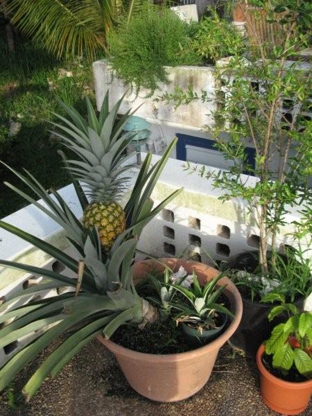
- HOW TROPICAL IS IT? Our first pineapple!Emailing: IMG_0094
|
- From: "Jane Higgins" <jhigginswear at islands.vi>
- Date: Wed, 1 Jul 2009 14:32:29 -0400
|
|
It's hot hot hot and the garden is cranking up. We've had some
really good rain in the last few days helping to
push out the Sahara dust. It seems
hotter than usual this early in the summer, have the fans cranked on "3" so not
sure what
we'll do when it comes to August and
September. The pool is at 92 degrees so looking forward to it becoming a
hot tub soon.
We are moving the tomatoes and peppers to
cooler spots on the east side now, the deck is baking them! This picture
shows
pomegranate, and herbs in the background
are tarragon and thyme. We have had nice cucumbers
and onions
are coming along ,everyone in the Caribbean should
be able to grow some food and have enough to give away.
Here is our first pineapple!!!! We
harvested it last night, it has 2 more babies coming on....took forever but
absolutely the best we've ever tasted!
Looks like we'll have a few days of blue
sky before the dust comes back and some moisture should be coming
up
from the South. Stay in touch and let
us know how you are doing. Being prepared is the best stress reliever for
later on in the season.
|
Attachment:
IMG_0094.jpg
Description: JPEG image
|
|
- BARKED THE DOGS!!!!
|
- From: "Jane Higgins" <jhigginswear at islands.vi>
- Date: Tue, 23 Jun 2009 15:53:37 -0400
|
|
Realizing that June 1 has come and gone and
that storm preparation season is here , it is the barking
dogs
that wake up the reality of storm season
every year around this little jungle hut on the west end of St Thomas. A
few weeks ago
just past midnight the thunder boomers
came, re-instilled total fear into our dogs Audrey and Ella (dumpster found
coconut retrievers) and put
Max the shepard on full alert. Audrey
and Ella born and raised in the islands have experienced loud blustery storms
for years , always forgetting
from quiet season to rumbling season that
those thunder boomers are BACK.
Again last Tuesday all day long the thunder
was huge and the crackling seemed so close. The dogs literally
ran out on the deck when the storm
was at a distance and tried to
bark it away. As the temperature dropped, their brave barking
turned to drooling whimpering as they
hid in the kitchen, below the desk or any
other place the human feet are. Audrey, Ella and Max are the lucky
pups. They hear the neighbor
dogs out in the tempest crying so loud at
the end of their chains, in the rain. Understanding abit about the science
of weather saves modern humans;
listening to the sound of confused fearful
whining and barking of those unprotected dogs is a sound hard to describe.
Reality has kicked in looking at today's
stormcarib map and we are in for some more rumbling, rain and panic among our
canine friends. If you can't
secure your dog in a dry safe place so fear
doesn't drive him to wander, if you think that it is decent to leave any animal
on a chain without shelter
in a storm then I wonder again, why have
dogs? They are the most social of our domesticated animals and just need to be
with us , with each other,
or safe and
secure.
Let us know how it is for you down island
with this wave coming thru, and excuse my rant about dogs. The cats
seem to be oblivious to all of it whether
inside or out in the rain. Maybe the
lucky dogs will come back as cats in the their next life!
|
|
|
- Getting started
|
- From: ronusvi at aol.com
- Date: Sun, 17 May 2009 08:58:31 -0400
|
Weather has been icky these last two weeks. Cleared up yesterday and looks good so far today. I hear there may be another passing through this week. Season starts soon! Will get more regular with my reports.
Ronnie
|
|


![[JustNorthOfRolloverPassBridge___After-ike11.jpg]](http://3.bp.blogspot.com/_Q16GN8b2AzE/SNfmV9M2JjI/AAAAAAAAAxM/W9vQoAqPQ8A/s1600/JustNorthOfRolloverPassBridge___After-ike11.jpg)

