
|
- - - 2009 Hurricane Season - - -
|
- Earthquake sinkhole
|
- By Tara Thompson <cheekytaz at candw.ky>
- Date: Tue, 19 Jan 2010 13:16:56 -0500
|
I believe the Cayman Compass also reported on this. Please check their
website for detailed info.
Sent from my iPhone

|
|
- Cayman Quake
|
- By Jason Swaby <narcedat220 at hotmail.com>
- Date: Tue, 19 Jan 2010 19:04:06 +0000
|
http://www.compasscayman.com/caycompass/2010/01/19/Earthquake-strikes-near-Cayman/
The only damage so far was a sink hole at Pirates Lair Lodge. Building shuck pretty good but that was it. Hope that's it, been almost five years since the last one we could feel here.
Windows Live Hotmail: Your friends can get your Facebook updates, right from Hotmail®.
|
|
|
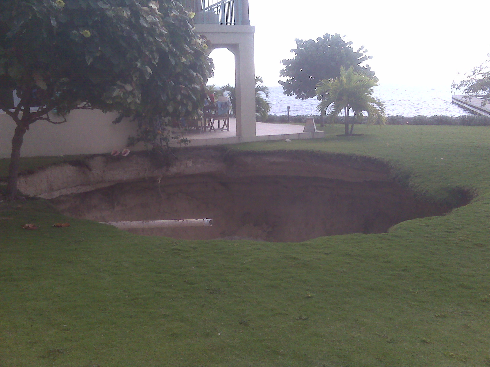
- FW: [Everyone] Effects from Earthquake - Check the pic
|
- By Simon Dodkins <simondodkins at hotmail.com>
- Date: Tue, 19 Jan 2010 18:16:42 +0000
|
Sink
hole from the Earthquake. This is a complex called Pirates Lair I believe.
Windows Live: Keep your friends up to date with what you do online.
|
Attachment:
IMG00009.jpg
Description: JPEG image
Visit our website at http://www.ubs.com

This message contains confidential information and is intended only
for the individual named.  If you are not the named addressee you
should not disseminate, distribute or copy this e-mail.  Please
notify the sender immediately by e-mail if you have received this
e-mail by mistake and delete this e-mail from your system.

E-mails are not encrypted and cannot be guaranteed to be secure or
error-free as information could be intercepted, corrupted, lost,
destroyed, arrive late or incomplete, or contain viruses.  The sender
therefore does not accept liability for any errors or omissions in the
contents of this message which arise as a result of e-mail transmission.
If verification is required please request a hard-copy version.  This
message is provided for informational purposes and should not be
construed as a solicitation or offer to buy or sell any securities
or related financial instruments.


UBS reserves the right to retain all messages. Messages are protected
and accessed only in legally justified cases.
|
|
- FW: Earthquake Release from HMCI
|
- By Simon Dodkins <simondodkins at hotmail.com>
- Date: Tue, 19 Jan 2010 18:11:22 +0000
|
January 19, 2009
Earthquake
At 9.23 am local time on Tuesday January
19, 2010 an earthquake measuring 5.8 on the Richter scale occurred 32 miles
south of Bodden Town,
Grand Cayman at coordinates 19.021 N, 80 deg
50.77 min W. The earthquake occurred at a depth of 6.2 miles.
911 has received no reports of injuries or
damage to structures.
No tsunami warning was issued from this
event.
At 10 am, the Director of Hazard
Management Cayman Islands, Mr. McCleary Frederick stated that residents can
return to offices and homes.
“Obviously in light of what has
happened in Haiti,
our residents are very sensitive to this type of occurrence. We are fortunate
that the Cayman Islands appears to have come
through unscathed, but it is reminder for everyone that they need to know how
to respond during an earthquake. In particular it is important to duck under a
strong piece of furniture, or at least protect the head with arms. If any
business organisations, schools or other entities would like to have HMCI
perform an earthquake education session or drill to better prepare for this
type of impact then please contact Simon Boxall or Omar Afflick at HMCI
(Telephone 526 2027)”
The Cayman Islands Government has
commissioned a seismic monitoring network, consisting of 4 state of the art
seismograph stations. Two seismographs will be located in Grand Cayman, one in
Little Cayman and another on the Island
of Cayman Brac. One of
these seismographs in Frank
Sound is already fully
functional and the earthquake was detected locally and the information relayed
through to HMCI as expected.
Earthquakes do occur from time to time in
the vicinity of the Cayman Islands as we are located near to the boundary of
the North American plate, with the Caribbean
plate sliding past to the south.
In December 2004 a 6.8 magnitude
earthquake occurred 20 miles to the south of Grand Cayman.
Since the formation of HMCI in 2006 the agency has embarked on a proactive
public education campaign to raise awareness of the earthquake threat in the Cayman Islands. Earthquake drills have been conducted involving
both private and public sector entities and the program has also been
instituted in Government schools.
For further information:
Contact
Simon Boxall
Public
Awareness and Information Officer
Hazard
Management Cayman Islands
Telephone:
916-3766
Email: Simon.Boxall at gov.ky;
List address: Prepared at gis.gov.ky Subscribe: Prepared-subscribe at gis.gov.ky Unsubscribe: Prepared-unsubscribe at gis.gov.ky
Windows Live Hotmail: Your friends can get your Facebook updates, right from Hotmail®.
|
|
|
- Earthquake damage
|
- By Tara Thompson <cheekytaz at candw.ky>
- Date: Tue, 19 Jan 2010 12:45:28 -0500
|
Sent from my iPhone
|
|
- Earthquake occurs close to the Cayman Islands
|
- By Kate Bates <kjcayman at gmail.com>
- Date: Tue, 19 Jan 2010 11:39:14 -0500
|
At 9.23 am the USGS reported a moderate earthquake of magnitude 5.8
occurred 32 miles ESE of Bodden Town, 40 miles ESE of George Town, 45
ESE of West Bay.
The earthquake occurred at a depth of 6.2 miles.
There have been no reports of damage or injuries received by 911.
There is no threat of a tsunami from this event.
|
|
- Note from our BVI office
|
- By Simon Dodkins <simondodkins at hotmail.com>
- Date: Mon, 16 Nov 2009 16:52:41 +0000
|
Not strictly an update for Cayman, but our BVI office has been in touch to advise as follows:
Due to severe weather, heavy rain, flooding, thunderstorms storms, heavy lighting, the Government has advised all non-essential Government workers to stay at home - here in the BVI, that also applies to local business staff.
I have managed to come into town, although it took one hour from our house to town (normally a 7 to 12 minute drive). There are no staff and most offices I can see are a) closed or b) without power.
For anyone needing to get in touch with the BVI, please note it appears most of Road Town is currently without power.
Best regards,
Simon
Windows Live: Keep your friends up to date with what you do online.
|
|
|
- Sunday Evening Update
|
- By "Chris McTaggart" <cmctagga at candw.ky>
- Date: Sun, 8 Nov 2009 19:01:21 -0500
|

Well we continued the Drizzle conditions through the day and
the mid-afternoon downpour was a reality, quite heavy rains. The night may
bring some occasional short bursts of heavy rain showers but the cloudy conditions
will disappear more throughout the early morning. Tomorrow we can expect a fairly
good day with some sunshine, but due to the saturated land, some convective rain
showers may occur in the Central and Western areas of the island.
Hurricane Ida continues her northbound track but I am still
betting on a North Easterly trend as it gets over the central portion of the
Gulf of Mexico. Persons in Upper Western Florida, the Panhandle, and
Alabama Louisiana coastline should watch updates on Ida closely, she has not
given up her strengthening yet and will not diminish in the Gulf as forecasted.
Current conditions:
Wind: ESE 5 MPH / Vis 10 NM / Clouds: 800 Few 1800
Scattered 7000 Broken 20000 Overcast / Temp: 75F / Dewpoint: 73F /
Humidity: 95% / Barometer 1010 Mb / Rain: Day 1.70 in Month 20.5 in Year 37.5
in (More than half total year rainfall occurred in November)
Have a good evening.
Chris

|
Attachment:
Captain Chris McTaggart.vcf
Description: Binary data
|
|
- Update
|
- By "mike barcroft" <mbar-cyb at candw.ky>
- Date: Sun, 8 Nov 2009 13:55:48 -0500
|
We can all breathe easier now in the Cayman
Islands as Hurricane IDA trundles Northwards – a “Strike”
would have been especially ironic and hard given events of last year on Cayman
Brac with Paloma.
Remember though – the Hurricane Season is not yet over
so still be prepared.
In the meantime, spare a thought for those still in the path
of Hurricane IDA be they on land or at sea and, for the crews of the Hurricane
Hunter Aircraft who clinically carry out their duties in “testing” and
often, “yet to be discovered” conditions.
ALL MESSAGES FROM THIS
SENDER HAVE BEEN SUBJECT TO FULL NORTON ANTI-VIRUS PROTOCOLS
|
|
|
- Sunday Mid-Day Update
|
- By "Chris McTaggart" <cmctagga at candw.ky>
- Date: Sun, 8 Nov 2009 12:07:50 -0500
|

Hello Storm Carib Watchers,
Well just as most posted for yesterday we had pretty much a
continuous drizzle with bands of rain for short periods. The heaviest of the
windy conditions occurred yesterday into the early evening. Drizzle with
occasional rain continued throughout the night and into this morning. Extremely
heavy downpour occurred around 10:30 and continued on for about an hour or so,
but has now stopped and back to a drizzle. As the afternoon moves on we can
expect a few more rain showers in bands which will diminish as evening moves
in.
Current Conditions:
Wind: SE at 15 MPH Occasional 25 MPH / Vis: 7 NM Drizzle /
Clouds 600 Scattered 1500 Broken 5000 Overcast / Temp: 75F / Dewpoint 72F /
Humidity: 92% / Barometer: 1010.5 Mb (Falling) / Days Rain: 1.04 in (Highest
Rate 6.0 in / Min)
Update later this evening.
Chris

|
Attachment:
Captain Chris McTaggart.vcf
Description: Binary data
|
|
- All Clear Issued
|
- By John Ferguson <caribblue at gmail.com>
- Date: Sun, 8 Nov 2009 10:32:45 -0500
|
Although the "ALL CLEAR" has been issued for the Cayman Islands, West Bay is experiencing a driving rain as I type this. Gusty winds blowing the trees, rain pelting the windows. A friend called from Georgetown and the same is happening at that location. Time to brew up some coffee and get inside chores done.
--
Aurabest,
John Ferguson
West Bay, Cayman Islands
ALPCA #10599
|
|
- IDA
|
- By Donna Sjostrom <cireba at mac.com>
- Date: Sun, 08 Nov 2009 10:20:52 -0500
|
I see no one has posted since yesterday morning. All day Saturday it
rained - in squalls it was a lot of rain and wind. By evening time
yesterday the rain had sort of stopped and the wind picked up. During
the nite not sure what happened, as I did not hear anything. Now this
morning I did see a break in the clouds and it seems calm, but as I
write this a strong squall is here with wind and rain. But all in all
I believe we are fine. Not sure what the seas will be like on the west
side of the Island now or later today. I know most boats moved to safe
harbours. Lets hope Ida gets tired when she gets to the Gulf. Good day
for football - GO Steelers!
Donna
|
|
- IDA remnants
|
- By michosch at gmail.com
- Date: Sun, 08 Nov 2009 15:22:16 +0000
|
IDA may have passed us by, but some parts of her are here this morning. Since about 15 minutes its been raining very heavily in George Town. Sky is dark and I think its going to rain for a while. Wind has picked up also.
Micho
http://cayman.micho.org
|
|
- Here comes the backlash of Ida....
|
- By Tara Thompson <cheekytaz at candw.ky>
- Date: Sat, 7 Nov 2009 16:03:23 -0500
|
I'm in Newlands, and from my patio I can hear strong gusts in the
distance.....
Suspect we will start to see some of the bad weather Ida is forecast
to bring Grand Cayman. Was going to the supermarket, but think I'll
hold off for a little while!!
I imagine the Tropical Storm warning may still be in effect taking
into consideration Ida has almost reached hurricane strength.
Sent from my iPhone
|
|
- Afternoon Update 2.00 pm
|
- By "Chris McTaggart" <cmctagga at candw.ky>
- Date: Sat, 7 Nov 2009 14:12:33 -0500
|

Hello All,
Teal 70...HURRICANE HUNTER AIRCRAFT FIND IDA STRONGER...
REPORTS FROM AN AIR FORCE RESERVE AIRCRAFT INDICATE THAT THE
MAXIMUM
SUSTAINED WINDS HAVE INCREASED TO NEAR 70 MPH...110
KM/HR...WITH
HIGHER GUSTS. IDA COULD BECOME A HURRICANE LATER TODAY
OR
TONIGHT BUT WEAKENING IS EXPECTED AFTER IDA ENTERS THE GULF
OF
MEXICO.
IDA IS MOVING TOWARD THE NORTH NEAR 9 MPH...15 KM/HR.
A TURN TOWARD
THE NORTH-NORTHWEST WITH A GRADUAL INCREASE IN FORWARD SPEED
IS
EXPECTED OVER THE NEXT COUPLE OF DAYS. ON THE FORECAST
TRACK...IDA
IS EXPECTED TO MOVE OVER OR JUST EAST OF THE NORTHEASTERN
PORTION OF
THE YUCATAN PENINSULA ON SUNDAY. IDA IS EXPECTED TO
MOVE INTO THE
SOUTHEASTERN GULF OF MEXICO SUNDAY NIGHT.
Current conditions:
Wind: SSE (160) at 15 Gusting 25-30 MPH / Vis: 7 NM Drizzle
/ Clouds: 800 Scattered 1500 Broken 6000 ft Overcast (Est) / Temp: 74F /
Dewpoint: 71F / Humidity: 90% / Barometer 1008 (Falling) / Rain: 1.25 inches
(Today)
Update later
Chris

|
Attachment:
Captain Chris McTaggart.vcf
Description: Binary data
|
|
- TS IDA
|
- By Micho <michosch at gmail.com>
- Date: Sat, 7 Nov 2009 13:27:15 -0500
|
|
Hello all,
Looks like this system will pass us by to the west! Great news! Its been raining so far pretty much all day. Nothing major, but a constant drizzle. Lots of dark clouds around so I would expect this to continue for the rest of the day. Officially, we are under a Tropical storm warning.
I was out scuba diving this morning. Water is still a lovely 85 degrees (down +-2 degrees in the last few weeks) and even in the rain, although not an optimal time to dive, it was still lovely. The sea was quite rough with some current ; good thing no one on the boat was sea sick! :-)
Cheers
Micho
More on Cayman on my blog at:
|
|
- Saturday Morning Nov 7, 2009
|
- By "Chris McTaggart" <cmctagga at candw.ky>
- Date: Sat, 7 Nov 2009 07:12:06 -0500
|

Good morning,
Overcast conditions continue to dominate the skies over the
Cayman Islands this morning a continuous moderate drizzle. A few short downfalls
of rain were noticed through the night and this morning so far.
Ida has emerged into the open water and has regained
Tropical Storm status with winds sustained around 45 MPH. Ida is moving toward
the north at 8 MPH. My unofficial forecast is still for Ida to continue
generally in a northerly track with a slow movement NNE as it crosses west and
abeam Cayman, then over the western tip of Cuba near Pinar Del Rio and into the
Gulf of Mexico and continue a NE track into upper western Florida.
Due to the large outflow east of IDA, the Cayman Islands can
expect increased rainfall amounts today starting from mid-morning and carrying
on throughout the day. Generally continuous drizzle with periods of moderate
rain.
Current conditions are:
Wind: ESE 10-15 Occasional Gusts 20 MPH / Vis: 7 NM in
Moderate Drizzle / Clouds: 500 ft Scattered, 1400 ft Broken, 5000 ft Overcast /
Temp: 75F / Dewpoint: 73F / Humidity: 94% / Barometer: 1009 mb / Rainfall: .5
inch
Hurricane Hunter Teal 70 was dispatched to Ida’s
location this morning, so we should have a detailed update on the storms status
on the 11 pm update.
Have a good day.
Chris

|
Attachment:
Captain Chris McTaggart.vcf
Description: Binary data
|
|
- Hunters Tomorrow
|
- By "Chris McTaggart" <cmctagga at candw.ky>
- Date: Fri, 6 Nov 2009 16:04:14 -0500
|

Hey HB,
Just letting you know that the Hunters are scheduled for
tomorrow “Teal 70 and Teal 71” both for Ida at 0600 and 1600.
Chris

__________ Information from ESET Smart Security, version of virus signature database 4580 (20091106) __________
The message was checked by ESET Smart Security.
http://www.eset.com
|
Attachment:
Captain Chris McTaggart.vcf
Description: Binary data
|
|
- Update
|
- By "mike barcroft" <mbar-cyb at candw.ky>
- Date: Fri, 6 Nov 2009 12:20:39 -0500
|
Chris,
I am also closely watching Ida for any “Paloma-esque”
turns/hooks – ironic considering the date!
Think that things will get more clear once she emerges into
NW Caribbean but still most info/prognoses will be from Satellite passes &
Buoy data as I do not think that any HH sorties are planned today or tomorrow
as yet.
Will be flying Cal
to NYC on 3 or 4 Dec when I get ticker sorted – if u are Capt will send
an “hallo” to u.
MB
ALL MESSAGES FROM THIS
SENDER HAVE BEEN SUBJECT TO FULL NORTON ANTI-VIRUS PROTOCOLS
|
|
|
- Hello Storm Carib
|
- By "Chris McTaggart" <cmctagga at candw.ky>
- Date: Fri, 6 Nov 2009 09:05:14 -0500
|

Good Morning Storm Carib Fans,
It certainly has been a longtime since I last posted, in
fact a whole year has gone by and it seems like yesterday that I was constantly
posting during Paloma. It sure seems like the old saying “Time Flies”
is more a reality now a days.
Well as I expected earlier this year, the first Caribbean
Storm would emerge from the SW corner of our waters. Ida got organized momentarily
over the past 48 hours but contended with landfall shortly thereafter near Bluefields
and is now a depression again. But needless to say I don’t think she is finished
yet, Ida will enter the warm waters off Honduras today as she progresses
northward and will start to reorganize and gain strength. As she moves
northward toward the Yucatan Peninsula passing just off the coast I expect a
more Northeasterly trend which is due to the higher lever flow that is very
prominent from the west over central Mexico. That along with the cold flow now
finding its way over the U.S. and south will also play a part in as much as
steering Ida over the southern tip of Cuba in a NE direction toward Florida.
This is just my observation remember and not official, I will even add that we
must pay close attention to Ida as depending on the strength of the factors
affecting, and also Ida strength, could even cause an easterly track jog as it moves
further north. Anyway those in the area should continue to monitor updates on
this storm movement regularly.
Further to the East, over Grand Cayman, we are seeing
increased cloudy conditions which no doubt is partly associated with Ida. Winds
are easterly with an occasional burst from the SE at around 30-35 MPH with
light drizzle. Here is the full scope:
Wind: E-SE 30-35 MPH / Visibility: 8 NM Moderate Drizzle / 1000
Ft Broken Cloud Bases / Temp: 75.6F / Dew Point: 69.8F
Humidity: 80% / Heat Index: 76H/74L / Windchill: 75F J / Barometer 1012.5 Mb / Rain: Today: .006
in Annual: 34.09 in
Well that it for now, back to my busy schedule. Oh by the
way, I still am a Captain with Cayman Airways but not flying as much recently
as I have taken on a higher management position, but as Christmas approaches
the flying will get more and more with the busy season. Hope to see some of you
on board, and if it is cold up north jump on our Washington, Chicago, or New
York flights and have a sunny and warm winter with us down here.
Have a great day and a lovely weekend!
Chris

__________ Information from ESET Smart Security, version of virus signature database 4578 (20091106) __________
The message was checked by ESET Smart Security.
http://www.eset.com
|
Attachment:
Captain Chris McTaggart.vcf
Description: Binary data
|
|
- Tropial storm Ida
|
- By Simon Dodkins <simondodkins at hotmail.com>
- Date: Wed, 4 Nov 2009 21:56:06 +0000
|
Tropical storm Ida has just formed off the coast of Honduras. It looks to be a similar late season storm to Paloma we had last year. So far:
The approximate Closest Point of Approach (CPA) is located near 18.5N, 86.1W or about 315.6 miles (507.8 km) from your location. The estimated time of when the center of the storm will be at that location is in about 100.6 hours (Sunday, November 8 at 8:36PM). This is an early estimate and subject to change.
Intensity wise it is supposed to go over land shortly which will damage the storm greatly, but then it is expected back over warm water where it might regroup. Forecasts have it back to a tropical storm status when it gets level with Cayman late weekend.
These are all early forecasts and subject to much change, so don't take your eye off this one in case it moves closer to Cayman.
And on a bank holiday weekend too!
Windows Live: Friends get your Flickr, Yelp, and Digg updates when they e-mail you.
|
|
|
- Reminds me of Paloma
|
- By Micho <michosch at gmail.com>
- Date: Wed, 4 Nov 2009 07:56:13 -0500
|
|
Hi everyone,
Long time no post! Its been a very welcome slow hurricane season.
However, the system near Panama reminds me a lot of how Paloma started. It went towards Cancun/Cozumel and then turned North-east towards Cayman.
Lets hope its not a repeat!
Lots of stuff about life in Cayman at
M.
|
|
- Rain gone.
|
- By "Jarrett Nicholson" <jaroo at weststartv.com>
- Date: Tue, 27 Oct 2009 23:06:51 -0500
|
|
I read in the paper awhile ago that this is one of
the driest years on record since they started keeping records, keep in mind that
was sometime in the 60's.
Well let me tell you Mother Nature tried to make up
for it yesterday. It rained ALL day. My thoughts..... just wonderful. No more
rain back to sun.
Come on December!
|
|
|
- Sunday.
|
- By "Jarrett Nicholson" <jaroo at weststartv.com>
- Date: Sun, 25 Oct 2009 12:05:18 -0500
|
|
Weather is nice, hot though. Been raining here and
there for the last few days, nothing out of the ordinary for this time of the
year.
Kaibo bound for a mudslide I think..... enjoy the
snow.
|
|
|
- Nice weather
|
- By William Mc Taggart <wmctagga at candw.ky>
- Date: Thu, 22 Oct 2009 13:03:38 -0500
|
|
|
|
- Rain at last
|
- By William Mc Taggart <wmctagga at candw.ky>
- Date: Mon, 19 Oct 2009 13:41:49 -0500
|
Location: Crewe Road, George
Town. Near Owen Roberts Int'l Airport
The rains began at about 10pm last night and when it stopped raining
this morning my station had recorded 6" rainfall. Cloudy conditions
persist and the forecast is for more rain, thanks to the stalled cold
front in the area.
The rain is welcome as we have not had much rainfall this year, in fact
we are about 15" below normal. Unfortunately when so much rain falls in
a short period time, flooding occurs in low lying areas.
Most days have been in the low to mid 90°'s since summer rolled around
and the break in the heat is welcomed. I look forward to the cooler
temperatures of the 'winter' months.
Current Conditions.
Cloudy.
Winds E at 5-10 knots
Temperature 78°F
Barometer 1013 hPa. 29.91 in
Humidity 92%
Rainfall last 24 hrs: 6"
October Rainfall; 9"
Total annual rainfall: 35 "
Official Forecast: Cloudy to overcast skies with
scattered showers and some thunder.
Showers will be locally heavy at times leading to additional flooding
of low lying areas. All residents should take necessary precautions.Winds
over open sea Northeast 10 to 15 knots with higher gusts
expected in and around showers
Have a wonderful day.
--
Local Weather Information
http://www.wunderground.com/weatherstation/WXDailyHistory.asp?ID=I90580545  My Station
http://www.weatherincayman.com/  Several Local Weather Stations
http://www.gov.ky/portal/page?_pageid=1142,1481932&_dad=portal&_schema=PORTAL  Official Weather Forecast
|
|
|
- Ummmmm
|
- By "Jarrett Nicholson" <jaroo at weststartv.com>
- Date: Sun, 18 Oct 2009 16:15:39 -0500
|
|
Worked on the water today, calm this morning but
the clouds are coming in, looks like lots of rain tomorrow. Just glad I don't
leave on the Mexican Baja....
Come on December.
|
|
|
- Blob
|
- By "Jarrett Nicholson" <jaroo at weststartv.com>
- Date: Sat, 17 Oct 2009 14:08:14 -0500
|
|
What is that blob way down south, worst time of the
year to see 'tings' as such.
Lots of lighting and thunder today in West Bay,
looking forward to some winter wind for the windsurfing habit!
|
|
|
- ERIKA
|
- From: helen chawe <helenchawe at yahoo.com>
- Date: Tue, 1 Sep 2009 15:25:15 -0700 (PDT)
|
Dear All
Looks like weve got lucky again! Its going away and now been named. Bahamas I hope you are prepared.....
Stay safe......
Chat again soon,
Helen |
|
|
- Look East
|
- From: helen chawe <helenchawe at yahoo.com>
- Date: Sun, 30 Aug 2009 11:56:55 -0700 (PDT)
|
Dear All,
Well first post of the season for me, was hoping not to do one! However, we need to keep an eye on the Invest! It dropped again last night so is even lower. Estimates are that it will be Miss Erika by lunchtime. It is in the same position as our uninvited guest in 2004. Lets pray it does take a turn north before coming into the Caribbean sea!
WATCH AND PREPARE!!!!!!
Chat again soon,
Helen |
|
|
- Cartagena
|
- From: Simon Dodkins <simondodkins at hotmail.com>
- Date: Sun, 30 Aug 2009 18:49:19 +0000
|
Just watching with interest that large ball of thunderstorms off the Colombian coast due south of us..so far nothing organised but storms have a habit of sneaking up on Cayman from this area.
Prospect is breezy today, sunny, high clouds and 32 degrees C (90f).
SMB might be a tad too breezy this afternoon - hate getting sand in my Corona!
Simon
Share your memories online with anyone you want anyone you want.
|
|
|
- Easy to drop your guard
|
- From: Simon Dodkins <simondodkins at hotmail.com>
- Date: Mon, 24 Aug 2009 16:47:34 +0000
|
Hello from George Town, Grand Cayman!
Your newest correspondent checking in and saying hello. George Town today is just beautiful, little wind, virtually cloud-free and just one cruise ship in port as of 11.30am.
It has been a very, very quiet hurricane season so far and it seems so easy to drop your guard and forget to check the weather. But coming into the height of the season this is the worst thing to do. Hurricanes can form anytime, but the next six weeks are the highest risk. Being under the "belly" of Cuba, wether systems need to come in low to effect the Caymans - typically those that skirt the Netherlands Antillies on their way west are the troubling ones, but also systems can form virtually on our doorstep off the coast of Colombia and go due noth like Paloma did last year. And that was November.
So get your hurricane supplies now, before the threat is on our doorstep and the shelves are empty. Be vigilent and check the weather often.
I'm still hoping not to have to put my storm shutters up this year - but I'm ready if I have to.
Simon
See all the ways you can stay connected to friends and family
|
|
|
- The seal is broken.....
|
- From: Tara Thompson <cheekytaz at candw.ky>
- Date: Thu, 13 Aug 2009 11:02:56 -0500
|
I suspect things will get interesting very soon. TD2 seems to have set
the hurricane season wheels in motion.
90L - it's probably too early to say, but I'm gonna stick my neck out
and say this will most likely be our first hurricane this year. At
the very least a strong tropical storm. I also suspect this will be
heading westward. I hope I'm wrong.
Sent from my iPhone
|
|
- More rain
|
- From: Micho <michosch at gmail.com>
- Date: Fri, 26 Jun 2009 23:09:55 -0500
|
|
Good evening,
Some heavy yet intermittent showers tonight. Lots of thunder, just like last night. The frogs are making all kinds of sounds.
Must be that "Invest 93L" system to the south of us.
Micho
|
|
- Calm before the REAL storm
|
- From: Tara Thompson <cheekytaz at candw.ky>
- Date: Thu, 25 Jun 2009 22:03:44 -0500
|
All calm in Prospect too. No wind, no rain. However distant thunder &
lightening still present. Judging by the sat maps, my opinion is this
"blob" has potential for development. We just got the outerbands of
the small but agressive looking "blob". Hopefully the upper winds will
restrict development further or at least send this storm on it's way
quick time!.
Sent from my iPhone
|
|
- Boom!
|
- From: Micho <michosch at gmail.com>
- Date: Thu, 25 Jun 2009 21:03:46 -0500
|
|
Massive thunder & rain in Savannah in Grand Cayman. Has stopped now, but can still hear thunder and seems to be getting closer. No power lost, but flickered a bit.
Micho
|
|
- Blob coming
|
- From: "Jarrett Nicholson" <jaroo at weststartv.com>
- Date: Thu, 25 Jun 2009 20:31:42 -0500
|
|
I'm in West Bay and no rain here yet. Looks
promising though.
J Nicholson.
|
|
|
- Thunderbolts & lightening very very frightening......
|
- From: Tara Thompson <cheekytaz at candw.ky>
- Date: Thu, 25 Jun 2009 19:53:28 -0500
|
The big blob approaching Cayman is giving us a taste of things to come
this evening. Hopefully power will remain on but we are getting our
generator ready just in case.
It's pouring down HARD! I'm in Prospect but my guess is that this will
be island wide soon, if not already.
Sent from my iPhone
|
|
- Rain!
|
- From: Micho <michosch at gmail.com>
- Date: Mon, 15 Jun 2009 15:10:23 -0500
|
|
Hi everyone,
Today we had a "monsoon" so to speak. Its been raining like mad for a few hours now. We also lost power for about 2h. I think most locals will be happy ; the grass & plants will grow and those with cisterns will get those filled up to the brim.
Generally weather has been quite nice recently. The water is a fantastic +-82 degrees. Went scuba diving on the North Wall yesterday. I highly recommend diving if you are looking for a great activity. There were people of all ages on the boat that took us out, so no excuses! :-)
Check out some of pictures I took while down there; we say eagle rays, barracuda, a moral eel & turtles. Amazing!
Cheers
Micho
|
|
- FROM THE BRAC
|
- From: "Carol Busby" <cbusby at candw.ky>
- Date: Wed, 20 May 2009 09:01:58 -0700
|
GOOD MORNING ALL, WE HAVE BEEN GETTING SOME MUCH NEEDED RAIN  OVER 6 INCHES
IN MY YARD IN THE CREEK . WE ARE STILL RECOVERING FROM PALOMA, AND SOME
ROOFS ARE NOT ON OR COMPLETED YET, AND SOME ARE FINDING THAT THEIR NEW ROOF
IS LEAKING. HURRICANE OFFICIALLY STARTS JUNE 1ST BUT I CAN SEE THE BRACKERS
HAVE THEIR EYE ON THE SKY STARTING NOW. I WILL KEEP IN TOUCH AS THE SEASON
PROGRESS'S.
REGARDS
CAROL BUSBY
|
|
