
|
- - - 2008 Hurricane Season - - -
|
- sad situation in martinica
|
- From: "Jean-Claude HUC" <jean-claude.huc2 at wanadoo.fr>
- Date: Tue, 5 May 2009 20:13:08 -0400
|
|
Very very heavy rain felt last night in
Martinica,and totals of 200,to 320mm ( 8 to 12 inches ) were recorded in 12
hours....
2 people confirmed dead,several
injured,mudslides,numerous houses destroyed,also roads!!!
A very sad situation,really. Don't know if
there are people on this board living in this island,but their testimony should
be appreciated...
|
|
|
- PROBLEM TO ACCESS TO STORM2K FORUM
|
- From: "Jean-Claude HUC" <jean-claude.huc2 at wanadoo.fr>
- Date: Tue, 24 Mar 2009 18:53:48 -0400
|
|
Hello,everyone.I cannot, like many others
access to the interesting weather forum storm2k,and cannot send any message to
the administrators.Does someone had a solution,or the moderators e -mail of this
forum???
Her in Guadeloupe,cloudy sky to day,but vrsy
little in rain.In fact since the begining of march this is 'le carème",as we
said here.
|
|
|
- FW: We are coming!
|
- From: "John Burnie" <john at yachtindaba.com>
- Date: Thu, 12 Mar 2009 10:50:31 -0400
|
Round Grenada
Race is this Saturday! We are coming to do battle in the 18kts wind promised!!
![20090223_caribbean600_start_wright_3[1].jpg](jpg3baanmNmSS.jpg)

With Kind Regards
JOHN BURNIE
|
|
|
- STRIKE IN GUADELOUPE
|
- From: "John Burnie" <john at yachtindaba.com>
- Date: Wed, 18 Feb 2009 16:40:47 -0400
|
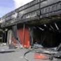
I imagine everyone has seen the
bad news about the riots, shootings and death in Guadeloupe. Our respected marine
chandlery Cap’n Nautique has been destroyed by fire. This is a bad moment
in the history of the island.
Guadeloupe
strike turns violent, one dead
POINTE-A-PITRE,
Guadeloupe (AFP) — France mobilised police reinforcements Wednesday after
an activist was killed in Guadeloupe as the month-long strike on the French
Caribbean island descended into rioting.Jacques Bino, aged in his 50s, was shot
dead while driving his car near a roadblock manned by armed youths who opened
fire at police with buckshot in Pointe-a-Pitre, the island's main city,
officials said.It was not immediately clear who shot him, but he was the first
victim of the escalating violence on an ordinarily tourist-friendly island
crippled since January 20 by a general strike over the high cost of living.There
were no police nearby," said local prosecutor Jean-Michel Pretre.Bino's
car was hit three times by 12-gauge solid shotgun slugs. Two rounds hit the
rear of the vehicle and the third was fired through a side passenger window and
fatally wounded Bino in the chest.These were not stray rounds," Pretre
said, adding that he was looking into the possibility that, given their age,
Bino and a passenger had been mistaken for plain-clothes police officers by the
youths.Six members of the security forces were slightly injured during clashes
with armed youths, police said.Prime Minister Francois Fillon condemned the
"extremely serious violence" and the interior minister dispatched
some 260 more police reinforcements to the island to help hard-pressed local
officers quell the unrest.Bino, a tax official, was returning from a labour
meeting, said Elie Domota, leader of the Collective Against Exploitation (LKP),
the coalition of unions and leftist groups that launched the strike.Gangs of
youths looted shops, smashed storefront windows and threw up burning roadblocks
overnight along the main streets of Pointe-a-Pitre and in at least two other
towns. Fourteen people were detained.The government's message is first of all
to appeal for calm, that is the most important thing," said spokesman Luc
Chatel in Paris.Everyone is better off finding a place at the negotiating table
than on the barricades," he told Europe 1 radio.Ary Chalus, mayor of the
town of Baie-Mahault where three police were hurt, described the scene as
"chaos."We have 15-year-old children who are clashing with police. We
may well have families in mourning," he warned.The LKP had said it planned
to step up protests this week after the government refused to bow to demands
for a monthly 200-euro (260-dollar) pay increase for low-wage earners.Domota
appealed for calm but also accused French authorities of treating the island,
one of its four overseas department, like a "colony."Guadeloupe is a
colony because they would never have allowed the situation to fester for so
long in a French department before taking action," Domota said on RTL
radio.The conflict has exposed race and class divisions on the island, where
the local white elite wields power over the black majority.The economy is
largely in the hands of the "Bekes," the local name for whites who
are mostly descendants of colonial landlords and sugar plantation slave owners
of the 17th and 18th centuries.A Socialist opposition leader, Malikh Boutih,
said it was "shocking" to watch a police force "almost 100
percent white, confront a black population" and drew a parallel with the
2005 suburban riots in France.There are no concrete buildings, there are palm
trees, but it's the same dead-end, the same 'no future' for young people, with
joblessness and a feeling of isolation," Boutih said.President Nicolas
Sarkozy plans to meet elected officials from Guadeloupe and other overseas
departments in Paris on Thursday to take stock.
With Kind Regards
JOHN BURNIE
|
|
|
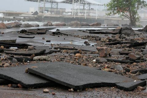
- Omar a Basse terre Guadeloupe
|
- From: Philippe de Lacaze <philippe.delacaze at videotron.ca>
- Date: Thu, 16 Oct 2008 21:19:10 -0400
|
|
Big tropical storm...a lot of dammaga along the
coast...very sad 1 photo vous a été
envoyée.
omar4.JPG
Ces photos ont été envoyées avec Picasa, un
logiciel de Google.
Pour l'essayer, rendez-vous sur : http://picasa.google.com/
|
Attachment:
omar4.JPG
Description: JPEG image
|
|
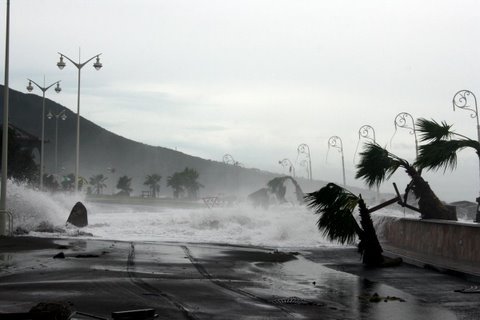
- Omar in Guadeloupe...
|
- From: Philippe de Lacaze <philippe.delacaze at videotron.ca>
- Date: Thu, 16 Oct 2008 21:15:28 -0400
|
|
1 photo vous a été envoyée.
omar3.JPG
Ces photos
ont été envoyées avec Picasa, un logiciel de Google.
Pour l'essayer,
rendez-vous sur : http://picasa.google.com/
|
Attachment:
omar3.JPG
Description: JPEG image
|
|
- Stay safe for all of you in the path of dangerous IKE ,stay safe please
|
- From: "Jean-Claude HUC" <jean-claude.huc2 at wanadoo.fr>
- Date: Sat, 6 Sep 2008 18:20:17 -0400
|
|
|
|
- Dark Clouds over our neighbours
|
- From: "John Burnie" <john at yachtindaba.com>
- Date: Tue, 29 Jul 2008 20:46:34 -0400
|

In Guadeloupe the weather is very fair – humid, no
rain and blue skies.
I rarely mention issues other than the weather but the “Dark
Clouds” gathered over our two neighbouring islands Montserrat and Antigua
at the same time are exceptional.
In Montserrat Soufriere collapsed on its inner core over the
weekend and clouds of ash reached heights of over 40,000 ft - easily visible from
Guadeloupe. I trust our friendly neighbours are spared any further worry after
the earthquakes and pyroclastic flows.
In Antigua there has been a terrible and tragic shooting of
a British honeymoon couple in a well known local hotel. The new bride died and
the young husband is not expected to survive. Antigua is an island I know well
and visit often as it is so close to Guadeloupe. The tragic incident that
happened there is unprecedented and I know all Antiguan people are shocked and
dismayed by the tragedy – many may have already read some of the adverse
publicity is has, and will, bring to the island. I have a great affinity for
the island and people of Antigua - I feel deeply sorry for the victims and
their family as well as for the good people and fine country in despair. In
parallel a dark cloud has been cruelly cast on their land as well.
With Kind Regards
JOHN BURNIE
General Manager
----------------------
NAUTOR'S SWAN CARIBBEAN
s.a.r.l
|
|
|
- C'mon NOAA!!
|
- From: "John Burnie" <john at yachtindaba.com>
- Date: Thu, 24 Jul 2008 15:48:09 -0400
|

C’mon NOAA and all the experts!! This lot off Africa
is a good deal more impressive than 97L - still no comment from the official
sources!
![2008_7_24_1800_MSG2_4_S2_grid[1].jpg](jpgTszKgtsalI.jpg)
With Kind Regards
JOHN BURNIE
General Manager
----------------------
NAUTOR'S SWAN CARIBBEAN
s.a.r.l
|
|
|
- Latest off AFRICA
|
- From: "John Burnie" <john at yachtindaba.com>
- Date: Thu, 24 Jul 2008 15:01:33 -0400
|

98L ????
With Kind Regards
JOHN BURNIE
General Manager
----------------------
NAUTOR'S SWAN CARIBBEAN
s.a.r.l
|
|
|
- 97 and 98?
|
- From: "John Burnie" <john at yachtindaba.com>
- Date: Thu, 24 Jul 2008 10:05:43 -0400
|

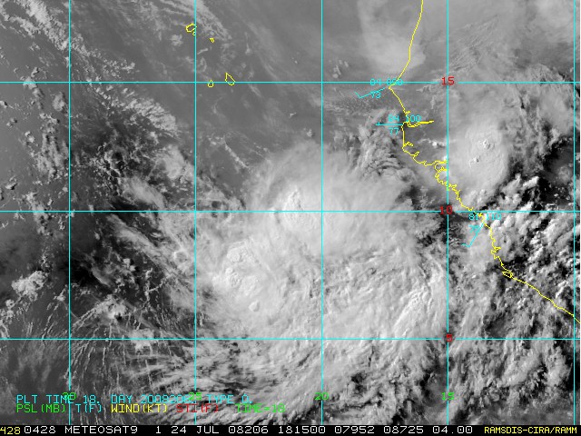
A good photo of 97L - not looking to be a problem for the
Caribbean at this time. A big wave with lots of convection has just exited
Africa and may be the birth o 98L(?)
![2008_7_24_1200_MSG2_16_S2_grid[1].jpg](jpgGEeLFYWyDm.jpg)
With Kind Regards
JOHN BURNIE
General Manager
----------------------
NAUTOR'S SWAN CARIBBEAN
s.a.r.l
|
|
|
- Fair Weather still in Guadeloupe
|
- From: "John Burnie" <john at yachtindaba.com>
- Date: Mon, 21 Jul 2008 09:54:29 -0400
|

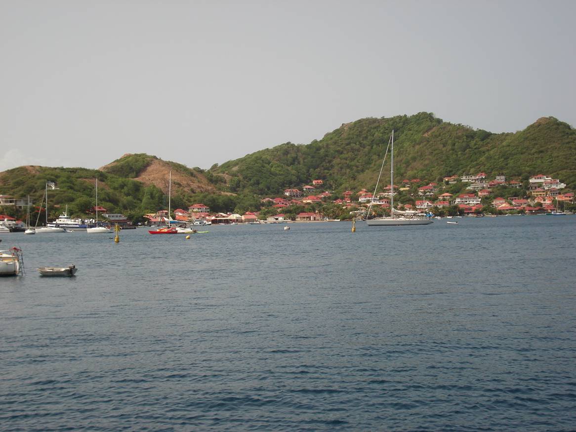
Despite the threats of TS all around us we are as ever unscathed
in Guadeloupe and weather is great. A little bit of rain recently did nothing
to dampen the spirits at the FISHING COMPETITION. The fish caught were large –
a HUGE TUNA nearly 65 kilo (served up on the beach in GOSIER) and a LAND ROVER
won for the RECORD MARLIN 497 lbs caught! See the weather here in LES SAINTES today
– TS? What TS? None round here thank goodness!
With Kind Regards
JOHN BURNIE
General Manager
----------------------
NAUTOR'S SWAN CARIBBEAN
s.a.r.l
|
|
|
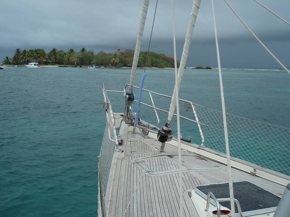
- The weather is FICKLE!
|
- From: "John Burnie" <john at yachtindaba.com>
- Date: Tue, 15 Jul 2008 15:46:23 -0400
|

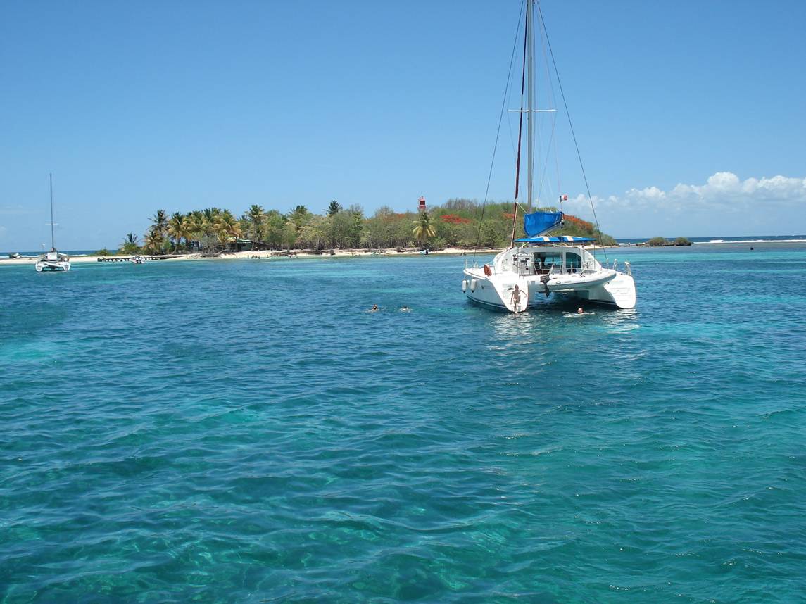
The weather IS fickle. 94 L MAY or MAY NOT upset our
cruising plans as it arrives on Wed night/Thursday – nobody knows.
See the contrasting photos of GOSIER just off the entrance
to the main harbour in Guadeloupe - taken on Bastille Day 14th, just
two hours apart!!
Just kidding, they are in fact same day but 12mths apart!
Guess which one is this year’s picture!
With Kind Regards
JOHN BURNIE
General Manager
----------------------
NAUTOR'S SWAN CARIBBEAN
s.a.r.l
|
|
|
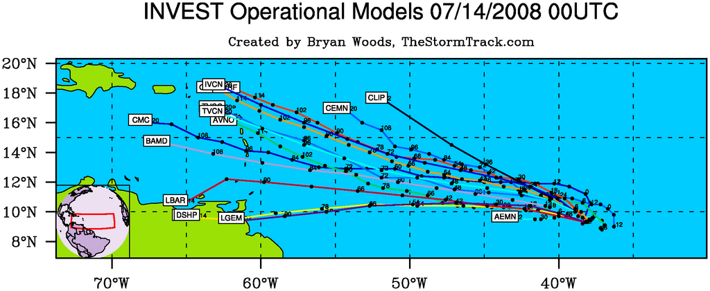
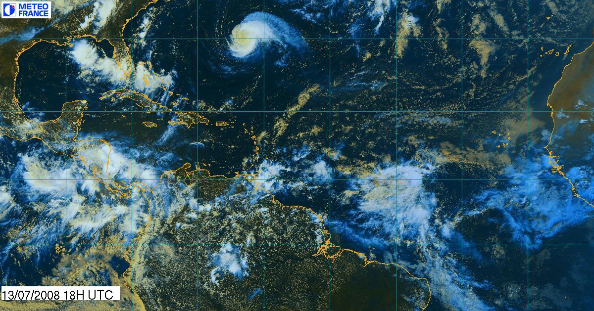
- 94 L is really spinning
|
- From: "John Burnie" <john at yachtindaba.com>
- Date: Mon, 14 Jul 2008 15:24:03 -0400
|
|
|
|
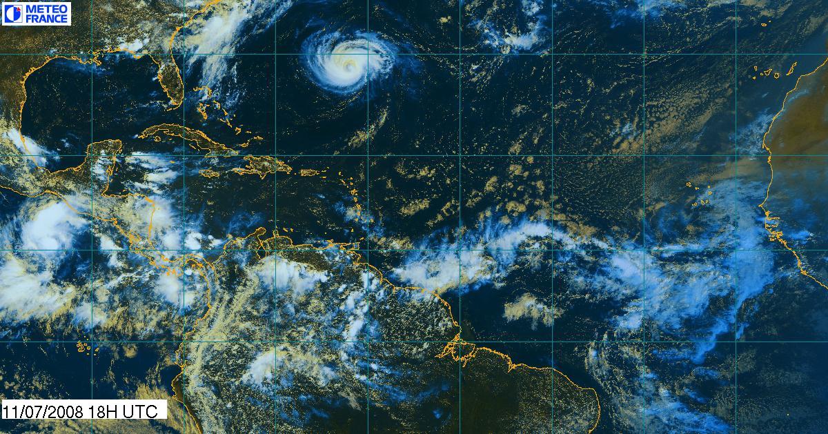
- CRISTOBAL on the way?
|
- From: "John Burnie" <john at yachtindaba.com>
- Date: Mon, 14 Jul 2008 11:13:41 -0400
|

Very early yet to say how 94L will develop or where it will
go. Every storm track here is a possibility. You can see the area of cloud
where the low is developing in the sat. picture. In Guadeloupe we will monitor
this new low very closely as it is pointing too close for comfort(again!) Lots
of action may happen in the next month and this is probably a good time for
everyone to look at their Hurricane Plan closely. The Caribbean has been free
of a really devastating Hurricane since IVAN in 2004. In EMILY DEAN and FELIX we
were in many ways very lucky - they were past us by the time they really got
going. 94L has all the characteristics and opportunity to get going as a strong
tropical storm before it crosses the Caribbean chain.
With Kind Regards
JOHN BURNIE
General Manager
----------------------
NAUTOR'S SWAN CARIBBEAN
s.a.r.l
|
|
|
- Latest Picture of BERTHA
|
- From: "John Burnie" <john at yachtindaba.com>
- Date: Fri, 11 Jul 2008 17:30:39 -0400
|

BERTHA still looking big and ugly – rather near
Bermuda now and predicted to possibly go back to Cat 2/3. A record Hurricane
for July in several respects. Guadeloupe weather is very good but we are
keeping our eye on the predicted development off Africa on Mon/Tues. BASTILLE
DAY and a holiday here on Monday by the way – watch out for fireworks and
GUILLOTINES!! Sacre Bleu!!
With Kind Regards
JOHN BURNIE
General Manager
----------------------
NAUTOR'S SWAN CARIBBEAN
s.a.r.l
|
|
|
- BERTHA
|
- From: "John Burnie" <john at yachtindaba.com>
- Date: Thu, 10 Jul 2008 11:49:42 -0400
|

Good hi res image of BERTHA (at 1500 UTC today) now heading
closer toward BERMUDA. Also check my earlier posting below to see link to forecast
of potential TS formation off Africa Tues next week.
![2008_7_10_1500_GOES12_6_S2_grid[1].jpg](jpglvE7VxCuut.jpg)
With Kind Regards
JOHN BURNIE
General Manager
----------------------
NAUTOR'S SWAN CARIBBEAN
s.a.r.l
|
|
|
- FW: Next Storm
|
- From: "John Burnie" <john at yachtindaba.com>
- Date: Thu, 10 Jul 2008 08:24:50 -0400
|

Hurricane Bertha was well forecast by the GFS model. Here is
their latest prediction.
http://www.txtornado.net/GFS/wna_slp_gfs_00z.htm#
Click the link and then select loop. This is the forecast
next low pressure coming.
There is a possibility of a hurricane forming off Africa
/ Cape Verde early next week which may affect the Leeward Islands in the
next 8-10 days.
With Kind Regards
JOHN BURNIE
General Manager
----------------------
NAUTOR'S SWAN CARIBBEAN
s.a.r.l
GUADELOUPE
French West Indies
|
|
|
- Which Way BERTHA?
|
- From: "John Burnie" <john at yachtindaba.com>
- Date: Sat, 5 Jul 2008 10:58:35 -0400
|

Historically a very slow build up (as exhibited by BERTHA)has
resulted in an impressive storm. I have been unnerved by the inconsistency by
the forecasters who have constantly altered the tracking to the west. I want to
believe that the wind shear and strengthening will cause a right turn. Then the
UK Met suddenly threw a spanner in that teory. Look at their predicted track –
straight at Antigua, Barbuda and Guadeloupe!! This is only a model but it still
is unnerving to see the islands are now actually lie in one predicted track.
With Kind Regards
JOHN BURNIE
General Manager
----------------------
NAUTOR'S SWAN CARIBBEAN
s.a.r.l
|
|
|
- Some statistics
|
- From: "John Burnie" <john at yachtindaba.com>
- Date: Fri, 4 Jul 2008 16:19:24 -0400
|
Here is some info regarding Guadeloupe’s history with
tropical systems and storms.

Guadeloupe's
History with Tropical Systems
br)=brush
(ts)=Tropical Storm (bd)=Back Door, meaning coming from over land from opposite
coast. Not all names are noted, also storms before 1950 were not named.
Years within 60 miles
1871,1872br,1879ts,1883br,1889-3ts,1889br,1891br,1893,1898ts,1899,1899br,1901tsbr,1915br
1916ts,1916br,1924tsbr,1928,1930-32ts,1950br,1953ts,1956,1958tsbr,1959ts
1961ts,1963tsbr,1964,1966,1981tsbr,1989,1995ts,1995br,1995,1996ts,
1998br,1999br,1999tsbr
Hit 40 times in 137yrs to
End of 2007
Names from list above
Baker,Edna,Betsy,Ella,Edith,Frances,Helena,Cleo,Inez,Gert,Hugo,Iris,
Luis,Marilyn,Hortense,Georges,Jose,Lenny
How often this area gets affected?
Brushed
or hit every 3.49 years
Average years between direct Hurricane hits.
Once
every 15.11 years
Statistically when this area should be affected next
3
years overdue
Last affected by
1999
Nov 19th T-Storm Lenny brushes just N.E by 40 miles with 70mph winds causes
very heavy wave damage on west coast as Lenny was pulling away.5 killed here.
2007
Damages to coasts from large North swell from storm in North Atlantic. 1 Death.
Guadeloupe Area / Hurricane past
1871
Aug
21st 115mph moving WNW passing just north
1893
Aug
16th 85mph from the SE
1899
Aug
8th 105mph from the ESE
1928
A
Cat 3 caused great damage to the area Sept 12th press 27.76 with
120mph winds.1,500 killed here,11 ft storm surge .Eye passes directly overhead.
In neighbouring Montserrat 42 dead & 5,000 homeless.
1956 Hurricane Betsy
Aug
11th devastates the area with 110mph winds, kills 6 here
1964 Hurricane Cleo
kills
14 people here. At Raizet Airport 15m north of eye min press 29.62 44mph gusts
to 81mph. 1,000 homes destroyed.
1966 Hurricane Inez
Sept
27th 120mph winds(air force recon) 27 killed 600 injured
1989 Hurricane Hugo
Sept
17th slams the area with 140mph winds killing 5 & injuring 80
leaving 11,000 homeless. Major damage in Marina, separate report to follow
1995 Hurricane Luis
brushes
well to the North. Guadeloupe got 80mph winds killing 3 & causing moderate
damage
1995 Hurricane Marilyn
Sept
15th just SW with 80mph winds bar 29.03 Minimal damage.
1998 Hurricane Georges
Brushes
well to the North moderate damage on north coast
1999 T-Storm Lenny
Nov
19th brushes just N.E by 40 miles with 70mph winds causes very heavy
wave damage on west coast as Lenny was pulling away. 5 killed here
With Kind Regards
JOHN BURNIE
General Manager
----------------------
NAUTOR'S SWAN CARIBBEAN
s.a.r.l
79 Residence Pieds Dans L' Eau
Marina Bas Du Fort
97110 Pointe a Pitre
GUADELOUPE
French West Indies
Tel: +590 590 933312
Fax: +590 590 936330
CELL: +590 690 723028
www.nautorgroup.com
www.nautorswancharter.com
|
|
|
- FW: Good Picture of BERTHA
|
- From: "John Burnie" <john at yachtindaba.com>
- Date: Fri, 4 Jul 2008 09:40:02 -0400
|

Good picture of BERTHA spinning away. I note the forecasters
keep adjusting the track “left”!!
![2008_7_4_1200_MSG2_16_S2_grid[1].jpg](jpgT2GHNg6b3r.jpg)
With Kind Regards
JOHN BURNIE
General Manager
----------------------
NAUTOR'S SWAN CARIBBEAN
s.a.r.l
|
|
|
- Good Picture of BERTHA
|
- From: "John Burnie" <john at yachtindaba.com>
- Date: Fri, 4 Jul 2008 09:31:13 -0400
|

Good picture of BERTHA spinning away. I note the forecasters
keep adjusting the track “left”!!
![2008_7_4_1200_MSG2_16_S2_grid[1].jpg](jpgYWRAn52D94.jpg)
With Kind Regards
JOHN BURNIE
General Manager
----------------------
NAUTOR'S SWAN CARIBBEAN
s.a.r.l
|
|
|
- FW: Invest 92 is East at this time
|
- From: "John Burnie" <john at yachtindaba.com>
- Date: Wed, 2 Jul 2008 00:52:39 -0400
|

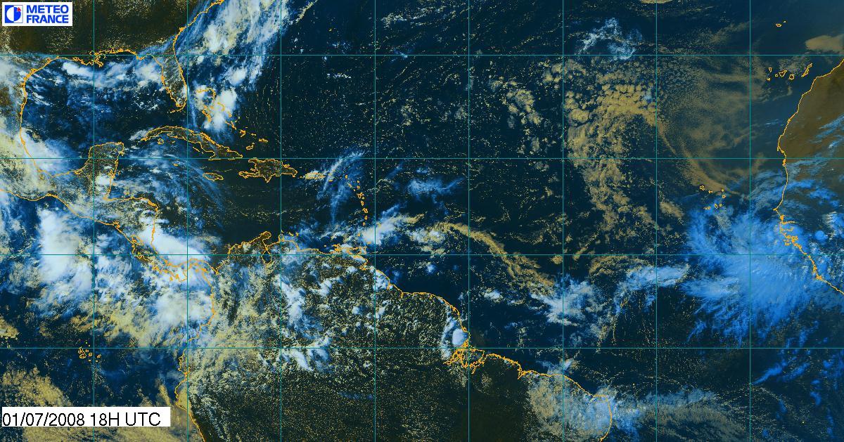
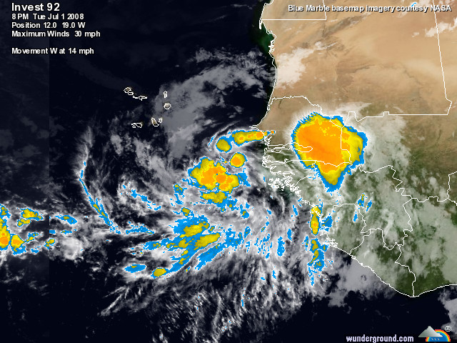
Posting again as the “prophets” are all starting to look
even harder at what is now Invest 92. Probability of TS formation looking 50%
and over now. Big picture below shows a big system off Africa!

With Kind Regards
JOHN BURNIE
General Manager
----------------------
NAUTOR'S SWAN CARIBBEAN
s.a.r.l
|
|
|
- FW: Invest 92 is East at this time
|
- From: "John Burnie" <john at yachtindaba.com>
- Date: Wed, 2 Jul 2008 00:48:59 -0400
|

Posting again as the “prophets” are all starting to look even
harder at what is now Invest 92. Probability of TS formation looking 50% and
over now.

With Kind Regards
JOHN BURNIE
General Manager
----------------------
NAUTOR'S SWAN CARIBBEAN
s.a.r.l
|
|
|
- FW: There's something out there 3......
|
- From: "John Burnie" <john at yachtindaba.com>
- Date: Mon, 30 Jun 2008 19:15:31 -0400
|

Here is the ECMWF prediction for 4th July.

NoGaps T + 132 hours
![slp23[1].png](pngoOrtcYLg9m.png)
Have not posted for a while now but Guadeloupe is green and
beautiful as ever.
The GFS model has been predicting TS formation for some days
now and slowly all the other models are starting to agree. The current thinking
is that a low pressure system will form off Africa in the next 48-60 hrs and
track eastwards. With elevated sea temperature it is considered that a TS will
form.
Click on this link and then select LOOP to see a model of
the storm forming. As ever my Captains and Crews are now considering the
integrity and safety of our yachts. Nothing changes!! http://www.txtornado.net/GFS/wna_slp_gfs_00z.htm
I also enclose this sat photo showing clearly the weather
developing on Africa which is the focus of the potential development. If you go
to the relevant websites you will see all the animations. It is not that
convincing but it is there nonetheless.

With Kind Regards
JOHN BURNIE
General Manager
----------------------
NAUTOR'S SWAN CARIBBEAN
s.a.r.l
|
|
|
- FW: There's something out there 3......
|
- From: "John Burnie" <john at yachtindaba.com>
- Date: Mon, 30 Jun 2008 19:07:05 -0400
|

Here is the ECMWF prediction for 4th July.

Have not posted for a while now but Guadeloupe is green and
beautiful as ever.
The GFS model has been predicting TS formation for some days
now and slowly all the other models are starting to agree. The current thinking
is that a low pressure system will form off Africa in the next 48-60 hrs and
track eastwards. With elevated sea temperature it is considered that a TS will
form.
Click on this link and then select LOOP to see a model of
the storm forming. As ever my Captains and Crews are now considering the integrity
and safety of our yachts. Nothing changes!! http://www.txtornado.net/GFS/wna_slp_gfs_00z.htm
I also enclose this photo showing clearly the weather
developing of Africa which is the focus of the potential development.

With Kind Regards
JOHN BURNIE
General Manager
----------------------
NAUTOR'S SWAN CARIBBEAN
s.a.r.l
|
|
|
- FW: There's something out there......
|
- From: "John Burnie" <john at yachtindaba.com>
- Date: Mon, 30 Jun 2008 09:30:12 -0400
|

Have not posted for a while now but Guadeloupe is green and
beautiful as ever.
The GFS model has been predicting TS formation for some days
now and slowly all the other models are starting to agree. The current thinking
is that a low pressure system will form off Africa in the next 48-60 hrs and
track eastwards. With elevated sea temperature it is considered that a TS will
form.
Click on this link and then select LOOP to see a model of
the storm forming. As ever my Captains and Crews are now considering the
integrity and safety of our yachts. Nothing changes!! http://www.txtornado.net/GFS/wna_slp_gfs_00z.htm
I also enclose this photo showing clearly the weather
developing of Africa which is the focus of the potential development.

With Kind Regards
JOHN BURNIE
General Manager
----------------------
NAUTOR'S SWAN CARIBBEAN
s.a.r.l
|
|
|
- There's something out there......
|
- From: "John Burnie" <john at yachtindaba.com>
- Date: Mon, 30 Jun 2008 07:26:02 -0400
|

Have not posted for a while now but Guadeloupe is green and
beautiful as ever.
The GFS model has been predicting TS formation for some days
now and slowly all the other models are starting to agree. The current thinking
is that a low pressure system will form off Africa in the next 48-60 hrs and
track eastwards. With elevated sea temperature it is considered that a TS will
form.
Click on this link and then select LOOP to see a model of
the storm forming. As ever my Captains and Crews are now considering the
integrity and safety of our yachts. Nothing changes!! http://www.txtornado.net/GFS/wna_slp_gfs_00z.htm
With Kind Regards
JOHN BURNIE
General Manager
----------------------
NAUTOR'S SWAN CARIBBEAN
s.a.r.l
|
|
|
