
|
|
- Updates from the Islands -- - Aruba - - |
|
|
| - trying again |
|
Good morning-
I tried to send this earlier but it got sent back (don't know why)
We recovered from the rain- but when I went to the Red Cross on Thursday- I should have had waders! We got 5inches in most parts of the island and some got 7 inches- that is 2 inches less than Ivan- Yikes. Good news is that no one got injured- just wet and alot of mud in their homes. Streets were rivers and rooi (the "drainage" we have here) were rapids. Here is a link to pictures taken around the island: http://www.diario-aruba.com/gallery/thumbnails.php?album=204&page=1 Take care! PS- Is anyone watching that blob to the west that is moving to the east? _________________________________________________________________Express yourself instantly with MSN Messenger! Download today it's FREE! http://messenger.msn.click-url.com/go/onm00200471ave/direct/01/ |
| - OMG! |
|
Oh my god, it has rained like hell here in Aruba! and the Weather
Service predicts eve more to come.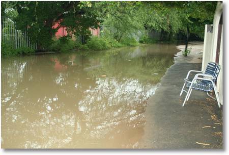 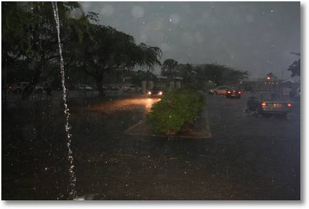
|
| - Wow- |
|
It started with a lightning show last night about 8. The rain started at
about 10- and it is still raining. As I write this inbetween flashes of
lightning and peals of thunder- I look into my backyard, LOTS of water. I
will check in later-as Aruba can't really handle alot of rain. Time to grab
my boots and check in at the Red Cross. I will update later. Take care and
stay dry!
_________________________________________________________________Express yourself instantly with MSN Messenger! Download today it's FREE! http://messenger.msn.click-url.com/go/onm00200471ave/direct/01/ |
| - Clouds |
|
|
Finlay my Internet Connection is restored, after the heavy rains on Monday. Rain clouds approaching on Wednesday, right now the radar image looks bad, more rain to come I'll post more pictures tomorrow! 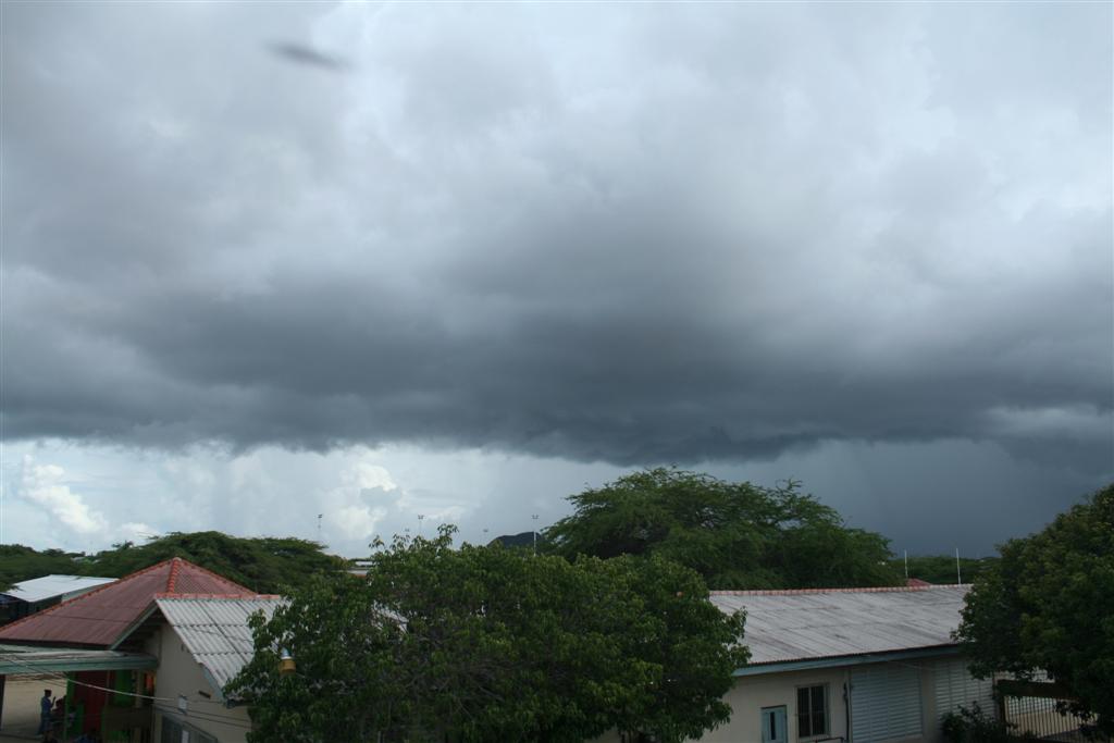
|
| - wow |
|
Last night we had RAIN like I haven't seen in a while. The thunder rattled
you teeth and the rain had it's own drum section playing on every roof.
Didn't think it was sooo bad until I tried to drive home from class- talk
about a shot of adrenaline- you couldn't see where the road or the puddles
started or ended. Wound up having a white knuckle ride home as you couldn't
get over 30kpm. I drove thru some streets that looked like the water was
knee deep and passing cars sprayed waterfalls onto my windsheild. They have
reports here of the usual spots going from roads to rivers. Our "dushi"
island is not used to so much rain so fast. Things look muddy, but better
today. It is a dead calm, but hopefully the breeze will pick up this
weekend. Hope everyone stays dry and the rest of the season is very boring.
_________________________________________________________________Express yourself instantly with MSN Messenger! Download today it's FREE! http://messenger.msn.click-url.com/go/onm00200471ave/direct/01/ |
| - No wind |
|
Our famous trade winds have taken a vacation- and it looks like they won't
be back until this weekend. The ocean is as calm as a pond with barely a
breath of air to ripple the surface. You can see straight down to the
individual blades of sea grass and the fish swimming in it. I was planning
to paint my kitchen- but it is just too hot. I'll take this as a sign that
i should be at the beach snorkeling today- the kitchen can wait. My kitties
have also given into the heat- they are now sleeping in the sink with water
dripping on them- who said cats don't like the water- and my dog is happily
licking the ice cubes in his water bowl. Miss Mermaid- hope the fin is on
the mend! Take care to all!
_________________________________________________________________Express yourself instantly with MSN Messenger! Download today it's FREE! http://messenger.msn.click-url.com/go/onm00200471ave/direct/01/ |
| - Where's the wind |
|
Whew- woke up and there is NO wind. This early and it is warm enough that
my Siamese is languishing in the sink with the water dripping on his furry
head. Our island is so used to being fanned by the famous trade winds.
Anything under 15mph and we start to ask "Where did they go?". I personally
think that the wind took the day off for Labor Day, as they only time we are
usually windless is when there is a storm close to us. Thankfully, the year
has been quiet, though Ernesto did give us a nice prep drill- my Mom and Dad
in NJ got more effect of him than we did here. I think they are still
manning the pumps ;-) Let's hope the rest of the season stays this quiet.
Take care to all on the islands- time for me to grab an iced coffee

_________________________________________________________________
FREE pop-up blocking with the new MSN Toolbar - get it now! http://toolbar.msn.click-url.com/go/onm00200415ave/direct/01/ |
| - Note from Aruba | |
| |
|
| - Official Report from MDNA&A | ||||||||||||||||
| ||||||||||||||||
|
CYCLONE MESSAGE NO. 4 INFORMATION ADVISORY NO. 4 Date: August 25, 2006 Time:12:00 P.M. (NOON). .....Tropical Depression Five Continues over Southeastern Caribbean..... SYSTEM IDENTIFICATION: Tropical Depression. INTENSITY CATEGORY: Close to Tropical Storm Strength. CENTER LOCATION: Within 80 km of 13.5N 66.4W or 250 km
Northeast of
Bonaire. LOCATION TIME: 11:00 A.M. MAX WINDS NEAR CENTER: 35 MPH / 55 KMH PRESENT MOVEMENT: West or 280 degrees at 15 MPH or 24 KM/HR. DISCUSSION: Tropical depression Five has changed little in strength and continues to move westward. The depression is expected to strengthen somewhat and forecasted to become a minimal tropical storm named Ernesto, later today. With the present forecast track the center of the system will pass well North of our islands late this evening.The area with tropical storm winds is not expected to affect the ABC islands, but rain bands associated with the system may cause showers and thundershowers. Although the system does not pose a direct threat to our islands, all interests should monitor the progress of this tropical cyclone closely. EFFECT ON LOCAL CONDITIONS: Weather conditions associated with this system will affect the ABC islands today, causing local rainshowers during the afternoon with increasing shower activity starting this evening and continuing through the night. Winds are generally expected to be light, but may reach gale force in gusts during heavy showers and blow temporarily from southerly directions. Seas may become temporarily rough during heavy showers and gusty winds. WATCHES/WARNINGS IN EFFECT: Owners of small craft are advised not to venture out of port this evening and tonight, and remain informed on the progress and development of the tropical depression. Local authorities and residents are advised to continue
monitoring
the further progress of this weather system. FORECAST CENTER POSITIONS:
END |
| - The calm before the storm |
|
The calm before the storm has started right now and satellite images
concur with this, the skies are clear I can even point out various
constellations right now. The depression seems to be organizing, but we will have to wait for the
next advisory around 5am.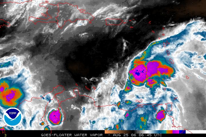 |
| - Oficial Report fron MDNA&A |
|
|
Telephone (+5999)
839-3360 839-3361 Telefax (+5999)
868-3999
869-2699 Web site: http://www.meteo.an,
E-mail: cur-met at meteo.an
INFORMATION ADVISORY NO. 2 Date: August 24, 2006 Time: 6:00 P.M. .....Tropical Depression #5 forms over Southeast Caribbean..... SYSTEM IDENTIFICATION: Tropical Depression. INTENSITY CATEGORY: Moderate CENTER LOCATION: 12.9 N 62.4 W or 640 km East Northeast of
Bonaire. LOCATION TIME: 5:00 P.M. MAX WINDS NEAR CENTER: 35 mph......55 km/hr with higher
gusts PRESENT MOVEMENT: Towards the West at 22 mph....35 km/hr DISCUSSION: The fifth tropical depression of the season has developed out of the strong tropical wave that entered the southeastern Caribbean this morning. The depression is expected to strengthen and become a minimal Tropical Storm named Ernesto by 2 a.m. early Friday morning. With the present forecast track this system is expected to pass well North of our islands during the course of Friday afternoon and evening.The area with tropical storm winds is not expected to affect the ABC islands, but rainbands associated with the system may cause showers and thundershowers. Although the system does not pose a direct threat to our islands, all interests should monitor the progress of the tropical depression closely. EFFECT ON LOCAL CONDITIONS: The weather associated with this system may affect the ABC islands tomorrow, Friday, causing showers and thundershowers mainly during the afternoon and evening hours . Winds are expected to become light during the passage of the wave, but may reach near gale force in gusts during heavy showers and may blow temporarily from southerly directions. Seas may become temporarily rough during heavy showers and gusts. WATCHES/WARNINGS IN EFFECT: Owners of small craft are advised to be cautious when venturing out of part and to remain informed on the progress and development of the tropical wave. Local authorities and residents are advised to continue monitoring the further progress of this weather system NEXT ADVISORY: Friday, 25 August 2006, 8:00 A.M.Forecast positions. Friday, 25/8 2 a.m. at 13.2 N 65.5W Weak Tropical Storm, center 325 km East Northeast of Bonaire Friday, 25/8 2 p.m. at 13.8 N 68.0 W Weak Tropical Storm, center 185 km North of Bonaire Saturday, 26/8 2 a.m. at 14.6 N 70.2 W Moderate Tropical Storm, center 225 km North Northwest of Bonaire END |
| - Signs of Ernesto??? |
|
It hasn't rained for quite some time till yesterday, Wednesday when
around 11:30am thunder began to rattle Aruba again for the first time
since December last year. Harmless rain fell on Aruba, but it did
remind us of that we are now in the Hurricane Season's busiest period,
today in a press conference organized by the Emergency Coordinator, he
made clear that Aruba is well prepared for moderate rainfall now, but
has concerns what the wind can do to the island in case of a hurricane.
Aruba has always had 3 scenarios the one that a storm will pass north
of us which is the most common one and most time it's harmless, the
other two are meanwhile less common but possible. These two are the
possible passage of a storm south of the island between Aruba and
Venezuela and a "wrong way Lenny" event, an eastward moving cyclone.
these two will bring the more severe winds closer to the island with
devastating effects. Our whole island infrastructure is localized on
the southern part of the island, here we have the water and electrical
stations and the oil refinery which are designed to whit stand a
category 3 hit, the airport and ports and last but certainty not least
the capital city of Oranjestad. Now which a possible formation of a
depression well south of the Caribbean sea, this is starting to worry
me again, although I don't think it will be a hurricane it could be a
tropical storm passing close to the ABC Islands the rain can spell
trouble for us, it has always do, but as always the forecast can
change, as I always say "Who are we??, to put rules on mother nature" - Marko Espinoza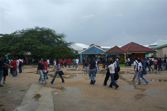 After the dark clouds in Colegio Arubano at Vondellaan in Oranjestad. 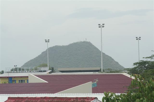 "Hooiberg" view from Vondellaan in Oranjestad, little bit hazy. |
| - Always on my day off!!! |
|
Greetings from Aruba. Well months of dry and dusty have passed. Yesterday
a nice spritz to settle the dust, but just because it is my day off this
week, it looks like we might get some real rain. It has been calmer
windwise today that is has been in a while and big grey clouds are looming
in the south east. Hopefully it will pass so I can be like Miss Mermaid and
spend a day at the beach when I don't have to be the lifeguard. I will keep
updating as our new season progresses- as we all hope, let it be a boring
and uneventful one!!
Regards,
Amy

_________________________________________________________________
Express yourself instantly with MSN Messenger! Download today - it's FREE! http://messenger.msn.click-url.com/go/onm00200471ave/direct/01/ |
| - Rainnnnnnnnn!!!!!!!!!!!!!!!!! |
|
Finally after weeks maybe months without rain, it's raining again
thanks to the Tropical Wave passing north of Aruba.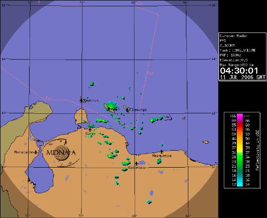
|
| - Rainfall Outlook 2006 |
|
|
From the MDNA&A 2005 Climatological Report: The outlook for the global sea surface temperature indicates, warm condition (0.5-1.0°<C above normal) in the Caribbean Sea and the North Tropical Atlantic for 2006. On the other hand in the equatorial Pacific Ocean the sea surface temperature will continue its cooling trend, which will reflect a near neutral to a weak La Niña conditions for first six months of 2006. As a result of a warm Caribbean Sea and the North Tropical Atlantic Ocean, the moisture in the atmosphere will be abundant in the Caribbean Area. The upper level westerly winds in the Caribbean that go along with a La Niña Event will be weak, hence enhancing the vertical development of deep convection. Therefore the rainfall for 2006 will be normal to above normal for the Netherlands Antilles and Aruba. |
| - High Winds |
|
|
Just like Bonaire here the roof is starting to rumble.... very windy.... according to MDNA&A It's going to be like this till Monday. Windsurfers ENJOY! |
| Back to top |